
2011 Annual Report Strategic Habitat Plan Accomplishments · PDF file2011 Annual Report...
28
2011 Annual Report Strategic Habitat Plan Accomplishments Aquatic Habitat, Terrestrial Habitat, Habitat and Access Maintenance, Lands Administration, Information, Education and Publication Branches, Wyoming Landscape Conservation Initiative Wyoming Game & Fish Department April 2012 Conserving Wildlife Serving People
Transcript of 2011 Annual Report Strategic Habitat Plan Accomplishments · PDF file2011 Annual Report...

2011 Annual ReportStrategic Habitat Plan
Accomplishments
Aquatic Habitat, Terrestrial Habitat, Habitat and Access Maintenance, Lands Administration, Information, Education and Publication
Branches, Wyoming Landscape Conservation Initiative
Wyoming Game & Fish DepartmentApril 2012
Conserving WildlifeServing People
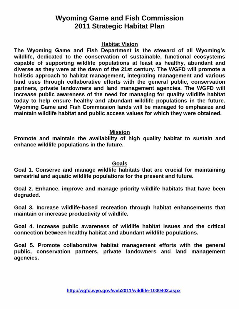
Wyoming Game and Fish Commission 2011 Strategic Habitat Plan
Habitat Vision The Wyoming Game and Fish Department is the steward of all Wyoming’s wildlife, dedicated to the conservation of sustainable, functional ecosystems capable of supporting wildlife populations at least as healthy, abundant and diverse as they were at the dawn of the 21st century. The WGFD will promote a holistic approach to habitat management, integrating management and various land uses through collaborative efforts with the general public, conservation partners, private landowners and land management agencies. The WGFD will increase public awareness of the need for managing for quality wildlife habitat today to help ensure healthy and abundant wildlife populations in the future. Wyoming Game and Fish Commission lands will be managed to emphasize and maintain wildlife habitat and public access values for which they were obtained.
Mission Promote and maintain the availability of high quality habitat to sustain and enhance wildlife populations in the future.
Goals Goal 1. Conserve and manage wildlife habitats that are crucial for maintaining terrestrial and aquatic wildlife populations for the present and future. Goal 2. Enhance, improve and manage priority wildlife habitats that have been degraded. Goal 3. Increase wildlife-based recreation through habitat enhancements that maintain or increase productivity of wildlife. Goal 4. Increase public awareness of wildlife habitat issues and the critical connection between healthy habitat and abundant wildlife populations. Goal 5. Promote collaborative habitat management efforts with the general public, conservation partners, private landowners and land management agencies. http://wgfd.wyo.gov/web2011/wildlife-1000402.aspx

i
TABLE OF CONTENTS
LIST OF ACRONYMS ....................................................................................................................................... ii
PERSONNEL DIRECTLY IMPLEMENTING THE STRATEGIC HABITAT PLAN IN 2011 .................................iv
INTRODUCTION ............................................................................................................................................... 1
PROJECT EXPENDITURES AND ACCOMPLISHMENTS ................................................................................ 2
STRATEGIC HABITAT PLAN – PROGRESS THROUGH 2011 ........................................................................ 6
CASPER REGION........................................................................................................................................... 21
CODY REGION ............................................................................................................................................... 29
GREEN RIVER REGION ................................................................................................................................. 43
JACKSON REGION ........................................................................................................................................ 53
LANDER REGION ........................................................................................................................................... 70
LARAMIE REGION.......................................................................................................................................... 78
PINEDALE REGION ........................................................................................................................................ 90
SHERIDAN REGION ..................................................................................................................................... 107

ii
LIST OF ACRONYMS
AHAB – Aquatic Habitat Biologist AIPA – Area Improvement Project Agreement AMA – Agricultural Management Assistance ARS – Agricultural Research Station AWEC – At-Will Employment Contract BEHI – Bank Erosion Hazard Index BLM – Bureau of Land Management BNF – Bighorn National Forest BOR – Bureau of Reclamation BTNF – Bridger-Teton National Forest CAP – Conservation Action Plan CCRP – Continuous Conservation Reserve Program CE – Conservation Easement CMR – Cokeville Meadows Refuge CRM – Coordinated Resource Management DU – Ducks Unlimited EC – Executive Committee EIS – Environmental Impact Statement EQIP – Environmental Quality Incentive Program FNAWS – Foundation for North American Wild Sheep FRPP – Farm and Ranch Lands Protection Program FSA – Farm Services Agency GRP – Grassland Reserve Program GVID – Greybull Valley Irrigation District HAEP – Habitat and Access Evaluation Process HEB – Habitat Extension Biologist HTAG – Habitat Technical Advisory Group JIO – Jonah Interagency Office L-D – Live-Dead LPDT – Local Project Development Team LSRCD – Little Snake River Conservation District MBCD – Medicine Bow Conservation District MBNF – Medicine Bow National Forest MDF – Mule Deer Foundation MIM – Multiple Indicator Monitoring NBS – Near-Bank Stress NEPA – National Environmental Policy Act NGO – Non-governmental Organization NPS – National Park Service NRCS – Natural Resources Conservation Service NWR – National Wildlife Refuge NWTF – National Wild Turkey Federation PAA – Public Access Area PAPO – Pinedale Anticline Project Office RMEF – Rocky Mountain Elk Foundation RMP – Resource Management Plan ROD – Record of Decision SAFE – State Acres for Wildlife Enhancement
iii
SCWPD – Sublette County Weed and Pest District SDI – Strength Deployment Inventory SEO – State Engineers Office SERCD – Saratoga-Encampment-Rawlins Conservation District SGI – Sage Grouse Initiative SHP – Strategic Habitat Plan SNWR – Seedskadee National Wildlife Refuge SWAP – State Wildlife Action Plan TCF – The Conservation Fund THB – Terrestrial Habitat Biologist TNC – The Nature Conservancy TSS – Teton Science School TSS-CRC – Teton Science School – Conservation Research Center TU – Trout Unlimited USDA – US Department of Agriculture USFS – US Forest Service USFWS – US Fish and Wildlife Service USGS – US Geological Survey WFARP – Wyoming Front Aspen Restoration Project WGBGLC – Wyoming Governor‟s Big Game License Coalition WGFC – Wyoming Game & Fish Commission WGFD – Wyoming Game & Fish Department WHAM – Watershed Habitat Assessment Methodology WHMA - Wildlife Habitat Management Area WIA – Walk-in Area WID – Watershed Improvement District WLCI – Wyoming Landscape Conservation Initiative WMA – Weed Management Area WSGALT – Wyoming Stock Growers Agricultural Land Trust WWDC – Wyoming Water Development Commission WWNRT – Wyoming Wildlife Natural Resource Trust WWSF – Wyoming Wild Sheep Foundation WYDEQ – Wyoming Department of Environmental Quality WYDOT – Wyoming Department of Transportation YNP – Yellowstone National Park

iv
PERSONNEL DIRECTLY IMPLEMENTING THE STRATEGIC HABITAT PLAN IN 2011
Administration or Statewide
Aquatic Habitat Paul Dey, Aquatic Habitat Program Manager, Cheyenne (307) 777-4505 Dennis Oberlie, Aquatic Habitat Supervisor, Lander (307) 332-7723, ext. 235 Tom Annear, Water Management Supervisor, Cheyenne (307) 777-4559 Mike Robertson, Instream Flow Biologist, Cheyenne (307) 777-4559
Habitat and Access Maintenance Bill Cowling, Branch Chief, Cheyenne (307) 777-4682 Scot Kofron, Assistant Branch Chief, Casper (307) 473-3430
Lands Administration Butch Parks, Supervisor, Cheyenne (307) 777-4596 Kerry Olson, Lands Resource Biologist, Cheyenne (307) 777-4563
Terrestrial Habitat Gary Butler, Terrestrial Habitat Program Manager, Cheyenne (retired) Bill Gerhart, Assistant Terrestrial Habitat Program Manager, Cheyenne (307) 777-4576 KaAnn Tray, Administrative Assistant, Cheyenne (307) 777-4518
Information and Publications Branch Mark Konishi, Information and Publications Branch Supervisor (307) 777-4547 Chris Madson, Wyoming Wildlife Magazine Editor (307) 777-4544 Judith Hosafros, Wyoming Wildlife Magazine Editorial Assistant (307) 777-4537 Al Langston, Information Specialist (307) 777-4540 Jeff Obrecht, Information Specialist (307) 777-4532 Ray Hageman, Audio Visual Production Specialist (307) 777-4533 Lindsay Simpson, Videographer (307) 777-4630 Jaimel Blajszczak, Graphic Designer (307) 777-4629
Wyoming Landscape Conservation Initiative Jim Wasseen, Coordinator (307) 352-0313
Casper Region - 3030 Energy Lane, Casper, WY 82601 Aquatic Habitat
Vacant, Aquatic Habitat Biologist Colin Tierney, Aquatic Habitat Project Biologist (307) 233-6414
Habitat and Access Maintenance Matt Pollock, Coordinator (307) 473-3426
Terrestrial Habitat Keith Schoup, Terrestrial Habitat Biologist (307) 473-3424 Willow Hibbs, Terrestrial Habitat Extension Biologist (307) 358-3050, ext. 116
Information Branch Robin Kepple, Senior Public Relations Specialist (307) 473-3409

v
Cody Region - 2820 St Hwy 120, Cody, WY 82414 Aquatic Habitat
Lewis Stahl, Fish Passage Coordinator (307) 527-7322, ext. *829
Habitat and Access Maintenance Steve Ronne, Supervisor (307) 527-7322, ext. *818 Craig Swanson, Crew Leader (307) 527-7322, ext. *834 Eric Shorma, Technician (307) 527-7125, ext. *834
Terrestrial Habitat Jerry Altermatt, Terrestrial Habitat Biologist (307) 527-7322, ext. *813 Amy Anderson, Habitat Extension Biologist, Worland (307) 347-2456, ext. 108
Information Branch Dennie Hammer, Public Relations Specialist (retired) (307) 527-7125, ext. *817
Green River Region - 351 Astle, Green River, WY 82935 Aquatic Habitat
Kevin Spence, Aquatic Habitat Biologist (307) 875-3225, ext. 253 Terrestrial Habitat
Ben Wise, Terrestrial Habitat Biologist (307) 875-3225, ext. 237 Information Branch
Lucy Diggins, Senior Public Relations Specialist (307) 875-3225, ext. 224
Jackson Region - Box 67, Jackson, WY 83001 Aquatic Habitat
Lara Sweeney, Aquatic Habitat Biologist (307) 733-2383, ext. 235
Habitat and Access Maintenance Matt Miller, Coordinator (307) 733-2383, ext. 239 Kade Clark, Specialist (307) 733-2383, ext. 232
Terrestrial Habitat Steve Kilpatrick, Terrestrial Habitat Biologist (retired) Alyson Courtemanch, Terrestrial Habitat Biologist (307) 733-2383, ext. 227
Information Branch
Mark Gocke, Senior Public Relations Specialist (307) 733-2321, ext. 231
Lander Region - 260 Buena Vista, Lander, WY 82520 Aquatic Habitat
Nick Scribner, Aquatic Habitat Biologist (307) 332-7723 Habitat and Access Maintenance
Brian Parker, Supervisor (307) 332-7723, ext. 231 Silas Deselms, Crew Leader (307) 332-7723, ext. 245 Skye Shaw, Specialist (307) 455-2421 Derek Lemon, Crew Leader (307) 332-7723, ext. 275

vi
Statewide Habitat Access and Maintenance Crew Amy Adams, Development Supervisor (307) 332-7723, ext. 270 Rick Harmelink, Crew Leader (307) 332-7723, ext. 251 Jerry Cowles, Specialist (307) 332-7723, ext. 245
Terrestrial Habitat Ron Lockwood, Terrestrial Habitat Biologist (307) 332-7723, ext. 223
Laramie Region - 528 S Adams, Laramie, WY 82070
Aquatic Habitat Christina Barrineau, Aquatic Habitat Biologist (307) 745-5180, ext. 240
Habitat and Access Maintenance Dave Lewis, Supervisor (307) 745-5180, ext. 248 Josh DeBerard, Crew Leader (307) 745-5180, ext. 246 Nick Kafcas, Coordinator (307) 532-2387 Steve Page, Specialist (307) 745-4046, ext. 248
Terrestrial Habitat Grant Frost, Terrestrial Habitat Biologist (307) 745-5180, ext. 230 Ryan Amundson, Habitat Extension Biologist, Wheatland (307) 331-0787
Pinedale Region - 117 S Sublette Ave, Pinedale, WY 82941 Aquatic Habitat
Floyd Roadifer, Aquatic Habitat Biologist (307) 367-4347, ext. 243
Habitat and Access Maintenance Ray Bredehoft, Supervisor (307) 367-4347, ext. 225
Terrestrial Habitat Jill Randall, Terrestrial Habitat Biologist (307) 367-4347, ext. 242
Brucellosis-Feedground-Habitat
Eric Maichak, Brucellosis Biologist (307) 367-4347, ext. 241 Habitat Mitigation
Dan Stroud, Habitat Mitigation Biologist, Jonah Interagency office (307) 367-3991 http://www.wy.blm.gov/jio-papo/index.htm
Sheridan Region - 700 Valley View, PO Box 6249, Sheridan, WY 82801
Aquatic Habitat Travis Cundy, Aquatic Habitat Biologist (307) 672-8003, ext. 230
Habitat and Access Maintenance
Seth Roseberry, Coordinator (307) 672-8003, ext. 240 Terrestrial Habitat
Bert Jellison, Terrestrial Habitat Biologist (307) 672-8003, ext. 229 Erika Peckham, Wildlife Biologist, Gillette (307) 670-8164
Information Branch
Warren Mischke, Senior Public Relations Specialist (307) 672-7418, ext. 235
1
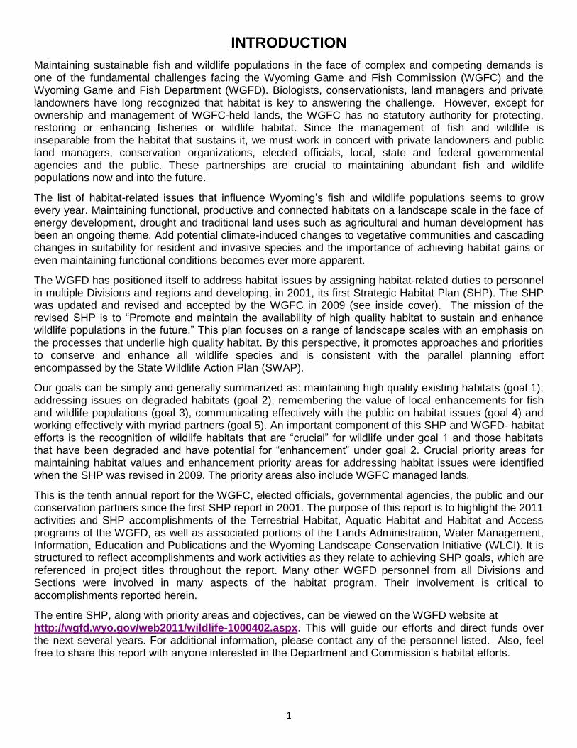
INTRODUCTION
Maintaining sustainable fish and wildlife populations in the face of complex and competing demands is one of the fundamental challenges facing the Wyoming Game and Fish Commission (WGFC) and the Wyoming Game and Fish Department (WGFD). Biologists, conservationists, land managers and private landowners have long recognized that habitat is key to answering the challenge. However, except for ownership and management of WGFC-held lands, the WGFC has no statutory authority for protecting, restoring or enhancing fisheries or wildlife habitat. Since the management of fish and wildlife is inseparable from the habitat that sustains it, we must work in concert with private landowners and public land managers, conservation organizations, elected officials, local, state and federal governmental agencies and the public. These partnerships are crucial to maintaining abundant fish and wildlife populations now and into the future. The list of habitat-related issues that influence Wyoming‟s fish and wildlife populations seems to grow every year. Maintaining functional, productive and connected habitats on a landscape scale in the face of energy development, drought and traditional land uses such as agricultural and human development has been an ongoing theme. Add potential climate-induced changes to vegetative communities and cascading changes in suitability for resident and invasive species and the importance of achieving habitat gains or even maintaining functional conditions becomes ever more apparent. The WGFD has positioned itself to address habitat issues by assigning habitat-related duties to personnel in multiple Divisions and regions and developing, in 2001, its first Strategic Habitat Plan (SHP). The SHP was updated and revised and accepted by the WGFC in 2009 (see inside cover). The mission of the revised SHP is to “Promote and maintain the availability of high quality habitat to sustain and enhance wildlife populations in the future.” This plan focuses on a range of landscape scales with an emphasis on the processes that underlie high quality habitat. By this perspective, it promotes approaches and priorities to conserve and enhance all wildlife species and is consistent with the parallel planning effort encompassed by the State Wildlife Action Plan (SWAP). Our goals can be simply and generally summarized as: maintaining high quality existing habitats (goal 1), addressing issues on degraded habitats (goal 2), remembering the value of local enhancements for fish and wildlife populations (goal 3), communicating effectively with the public on habitat issues (goal 4) and working effectively with myriad partners (goal 5). An important component of this SHP and WGFD- habitat efforts is the recognition of wildlife habitats that are “crucial” for wildlife under goal 1 and those habitats that have been degraded and have potential for “enhancement” under goal 2. Crucial priority areas for maintaining habitat values and enhancement priority areas for addressing habitat issues were identified when the SHP was revised in 2009. The priority areas also include WGFC managed lands. This is the tenth annual report for the WGFC, elected officials, governmental agencies, the public and our conservation partners since the first SHP report in 2001. The purpose of this report is to highlight the 2011 activities and SHP accomplishments of the Terrestrial Habitat, Aquatic Habitat and Habitat and Access programs of the WGFD, as well as associated portions of the Lands Administration, Water Management, Information, Education and Publications and the Wyoming Landscape Conservation Initiative (WLCI). It is structured to reflect accomplishments and work activities as they relate to achieving SHP goals, which are referenced in project titles throughout the report. Many other WGFD personnel from all Divisions and Sections were involved in many aspects of the habitat program. Their involvement is critical to accomplishments reported herein. The entire SHP, along with priority areas and objectives, can be viewed on the WGFD website at http://wgfd.wyo.gov/web2011/wildlife-1000402.aspx. This will guide our efforts and direct funds over the next several years. For additional information, please contact any of the personnel listed. Also, feel free to share this report with anyone interested in the Department and Commission‟s habitat efforts.

2
PROJECT EXPENDITURES AND ACCOMPLISHMENTS
Habitat program performance in terms of approximate statewide expenditures and on-the-ground accomplishments for calendar year 2011 are summarized in the following sections.
A. Habitat Program Expenditures
I. Approximate WGFD trust, fish passage and non-recurring funds (figures rounded to the nearest $1,000) expended for on-the-ground projects primarily for implementation of SHP goals and management of WGFC managed lands during calendar year 2011. (These figures do not include personnel salaries, supplies, materials, equipment used for routine WGFD maintenance and operation functions and WGFC property tax and lease payments). Department Funds Expended on SHP Goals: $3,231,000
II. Non-department funds expended for implementing SHP goals for calendar year 2011 from or in collaboration with various sources including: a) Wyoming Wildlife and Natural Resources Trust Fund (WWNRT); b) USDA Farm Bill federal government funds; c) other federal government funding programs; d) other state and local government funding sources; e) nongovernmental organizations; f) Wildlife Heritage Foundation of Wyoming (WHFW), including funds through the Wyoming Governors Big Game License Coalition (WGBGLC); g) private landowner contributions (including in-kind); h) corporations and businesses; and i) private donors. Non-Department Funds Expended on SHP Goals: $7,692,000 (See table below for a partial list of major funding partners and approximate amounts contributed by each source wherein WGFD personnel were heavily involved with planning, on-the-ground implementation and/or oversight or verification of expenditures on the ground during 2011). III. GRAND TOTAL FOR SHP GOALS: $10,923,000 (These figures do not include personnel salaries, supplies, materials, and equipment used for routine WGFD maintenance and operation functions and WGFC property taxes or lease payment expenditures). In other words, the WGFD was able to utilize and/or oversee funding from outside sources amounting to approximately $2.40 for each WGFD dollar expended for on-the-ground fish and wildlife habitat activities. This outside funding is a critical element for implementing the SHP and conserving our wildlife resources in collaboration with the many dedicated partners throughout the state. Overall, personnel directly involved in implementing SHP goals oversaw spending of approximately $8,084,000 of WGFD regular maintenance and operating funds, State Wildlife Grants from US Fish and Wildlife Service (USFWS) and Department Trust Fund monies. This figure includes wages, benefits, equipment operation expenses, supplies and on-the-ground improvement material expenses allocated as follows: approximately 55% for personnel, which includes habitat inventories, monitoring, project contact oversight, project design and implementation and promoting collaborative habitat management efforts with the general public, conservation partners, private landowners and land management agencies. Without the dedication and passion of field personnel, none of these habitat projects would happen. The remainder of the funding was allocated as follows: 5% for vehicles and heavy equipment and 40% for materials and supplies.

3
Personnel overseeing the WGFD Education, Information and Publications Program efforts relative to directly implementing SHP goal 4 during 2011 spent approximately 12.5% of their time on these activities totaling approximately $108,000 of regular WGFD maintenance and operating funds. Information and education are critical for maintaining current and long-term future, social, political and financial support for wildlife habitat program related efforts. Lastly, personnel within the Lands Administration Branch conduct annual WGFC property rights monitoring, oversee payment of WGFC property taxes in each county and lease payments to State Office of Lands Investment and others.
B. On-the Ground Accomplishments
It is extremely challenging to trace the links between proven habitat enhancements and fisheries and wildlife population responses. However, the following table summarizes some of the more quantifiable aspects of 2011 on-the-ground accomplishments. Activity Accomplishment
Detailed stream assessments 6 streams totaling 4,633 ft
Riparian habitat assessments 1 assessment on 6 miles of a stream
Watershed stream assessments 18 assessments on 69 miles
Stream bank enhancements 7 projects totaling 7,225 ft
Instream structures 125 installed
Instream flow segments 5 filed at 21 miles
Fish screens installed 2
Fish passage structures installed 5
Fish passage upstream miles 315 miles connected
Fish passage structures monitored and maintained 5 monitored, 2 maintained
Project monitoring - detailed stream channel 5 monitored totaling 20,600 ft
Management monitoring - detailed riparian 35 monitored totaling 24,528 ft
Project monitoring - photo, other 22 streams totaling 8 miles
Aspen/cottonwood browse monitoring 26 sites
Stream habitat monitoring 19 sites
Fish tracking or entrainment investigations 3
Beaver transplanted 12
Riparian habitat protection, enhancement, management 30 projects on 700 acres
Private landowner contacts 278 contacts yielding 115 projects
Technical assistance requests 211
Conservation easements being worked on and coordinated with partners
36 easements totaling 94,916 acres
WGFC conservation easements 2 easements totaling 1,539 acres
Public Fishing Access Projects 3 projects totaling 3 miles
Public Hunting Access Projects 1 projects totaling 70 acres
BLM RMP or USFS Cooperator Status 6 projects
Trees or shrubs planted 10,765
Herbicide vegetation treatments to control noxious or invasive weeds primarily including cheatgrass, prickly pear, Russian olive and salt cedar
17,462 acres
Upland grass, forb and food plot seeding 1,565 acres
Mechanical tree removal mainly conifer removal from aspen stands, juniper, Russian olive and salt cedar removal
5,530 acres
Mowing, chopping, and Lawson aerator treatments mainly in sagebrush and grassland communities and on meadows
454 acres
Water wells drilled 9
4
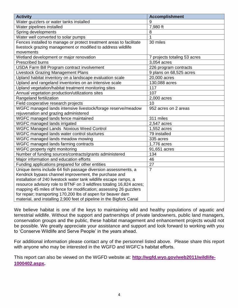
Activity Accomplishment
Water guzzlers or water tanks installed 9
Water pipelines installed 7,980 ft
Spring developments 8
Water well converted to solar pumps 1
Fences installed to manage or protect treatment areas to facilitate livestock grazing management or modified to address wildlife movements
30 miles
Wetland development or major renovation 7 projects totaling 53 acres
Prescribed burns 3,054 acres
USDA Farm Bill Program contract involvement 226 program contracts
Livestock Grazing Management Plans 9 plans on 68,525 acres
Upland habitat inventory on a landscape evaluation scale 20,000 acres
Upland and rangeland inventories on an intensive scale 130,088 acres
Upland vegetation/habitat treatment monitoring sites 117
Annual vegetation production/utilizations sites 107
Rangeland fertilization 2,000 acres
Field cooperative research projects 10
WGFC managed lands intensive livestock/forage reserve/meadow rejuvenation and grazing administered
952 acres on 2 areas
WGFC managed lands fence maintained 311 miles
WGFC managed lands irrigated 2,547 acres
WGFC Managed Lands Noxious Weed Control 1,552 acres
WGFC managed lands water control stuctures 79 installed
WGFC managed lands meadow mowing 335 acres
WGFC managed lands farming contracts 1,776 acres
WGFC property right monitoring 91,651 acres
Number of funding sources/contracts/grants administered 134
Major information and education efforts 46
Funding applications prepared for other entities 27
Unique items include 64 fish passage diversion assessments, a Kendrick bypass channel improvement, the purchase and installation of 240 livestock water tank wildlife escape ramps, a resource advisory role to BTNF on 3 wildfires totaling 16,824 acres; mapping 45 miles of fence for modification; assessing 26 guzzlers for repair; transporting 170,200 lbs of aspen for beaver dam material, and installing 2,900 feet of pipeline in the Bigfork Canal
7
We believe habitat is one of the keys to maintaining wild and healthy populations of aquatic and terrestrial wildlife. Without the support and partnerships of private landowners, public land managers, conservation groups and the public, these habitat management and enhancement projects would not be possible. We greatly appreciate your assistance and support and look forward to working with you to „Conserve Wildlife and Serve People‟ in the years ahead.
For additional information please contact any of the personnel listed above. Please share this report with anyone who may be interested in the WGFD and WGFC‟s habitat efforts.
This report can also be viewed on the WGFD website at: http://wgfd.wyo.gov/web2011/wildlife-
1000402.aspx.
5
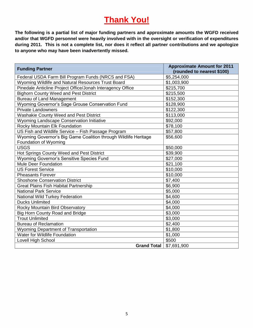
Thank You!
The following is a partial list of major funding partners and approximate amounts the WGFD received
and/or that WGFD personnel were heavily involved with in the oversight or verification of expenditures
during 2011. This is not a complete list, nor does it reflect all partner contributions and we apologize
to anyone who may have been inadvertently missed.
Funding Partner Approximate Amount for 2011
(rounded to nearest $100)
Federal USDA Farm Bill Program Funds (NRCS and FSA) $5,254,000
Wyoming Wildlife and Natural Resources Trust Board $1,003,900
Pinedale Anticline Project Office/Jonah Interagency Office $215,700
Bighorn County Weed and Pest District $215,500
Bureau of Land Management $152,300
Wyoming Governor‟s Sage Grouse Conservation Fund $128,900
Private Landowners $122,300
Washakie County Weed and Pest District $113,000
Wyoming Landscape Conservation Initiative $92,000
Rocky Mountain Elk Foundation $78,100
US Fish and Wildlife Service – Fish Passage Program $57,800
Wyoming Governor‟s Big Game Coalition through Wildlife Heritage Foundation of Wyoming
$56,600
USGS $50,000
Hot Springs County Weed and Pest District $39,900
Wyoming Governor‟s Sensitive Species Fund $27,000
Mule Deer Foundation $21,100
US Forest Service $10,000
Pheasants Forever $10,000
Shoshone Conservation District $7,400
Great Plains Fish Habitat Partnership $6,900
National Park Service $5,000
National Wild Turkey Federation $4,600
Ducks Unlimited $4,000
Rocky Mountain Bird Observatory $4,000
Big Horn County Road and Bridge $3,000
Trout Unlimited $3,000
Bureau of Reclamation $2,400
Wyoming Department of Transportation $1,800
Water for Wildlife Foundation $1,000
Lovell High School $500
Grand Total $7,691,900

6
STRATEGIC HABITAT PLAN – PROGRESS THROUGH 2011
Plans have little value unless consulted, followed and frequently updated to reflect values and new issues. The SHP was updated in 2009 and included 111 actions to meet the five goals listed on the inside cover. This mid-term analysis attempts to address the following questions: 1) Are these actions being pursued or completed? 2) Have some been forgotten? and 3) Most importantly, what should we focus upon in the future? To ensure the SHP remains a directing force toward wildlife habitat gains, a department working group, the Habitat Technical Advisory Group (HTAG), reviewed the status of department efforts toward the various SHP actions. In fact, this status review is called for under SHP action 1.A.vi.b. The HTAG review was a straightforward and simple assessment that asked whether there was no, some, or complete progress on each of the SHP actions over the three-year period 2009-2011. It also asked whether there was likely to be progress, based on current work loads, emerging values and issues relative to these actions through 2013. Twelve managers and individuals representing programs for terrestrial habitat, aquatic habitat, habitat and access, lands, habitat protection, biological services, GIS and information & education were polled. While the perspectives of a dozen individuals certainly do not represent a comprehensive assessment, it provides a touchstone to identify areas we need to address as we begin preparing an updated SHP for 2014. It is obvious that several of the 111 actions are redundant. That is, the same action is repeated under multiple goals. This was intentional as the SHP was developed to ensure actions proposed under one goal would be pursued under other goals. Another insight found during the assessment was that many of the actions are meant to be continuously pursued and would not ever be considered totally completed or “done.” Accounting for the redundant ones, there are 105 actions. Of these, 40 actions were judged to have been completed or have had substantial progress. An additional 14 actions, for a total of 54, are anticipated to be fully implemented by the end of 2013. Therefore, with the current level of attention to the actions identified in the SHP, we are on track to fully address about half of them. Most of the remaining actions are receiving attention. There were five actions identified as having no progress to date. Three of these involve supplying information to help private landowners improve habitat (“Produce and distribute a Wyoming specific guide to improving wildlife habitat on private land,” “Review all habitat technical bulletins produced by the WGFD for current relevancy and purpose” and “Develop new habitat technical bulletins that will benefit land managers”). In the upcoming year, the WGFD will renew the focus on these actions, starting with a review of the bulletins to identify which may be most relevant to update. The other two actions not being pursued to date are: 1) “Develop a means for the public to provide input into the MLAs (Managed Land and Access Summaries prepared for WGFC held properties),” and 2) “Use MLAs to teach and educate the public about good habitat stewardship and wildlife-oriented land management practices.” The WGFD, through the Habitat and Access Branch, will actively work on a process in 2012 for the public to become more involved in the long-term direction of the management of the WHMAs by providing input into the MLAs. Part of this process will include educating the public on habitat management and wildlife-oriented land management practices. As a result of this review, a few actions were flagged as perhaps receiving inadequate attention and include: 1) “Use the enhancement and crucial areas that have remote sensing applications to help focus annual inventories;” 2) “Inform landowners, land managers, and conservation organizations about relationships between pond development, introduced species and water quality impacts;” 3) “Provide information to pond developers to incorporate natural and sustainable designs that benefit
7
the broad community of native species;” and 4) “Continue to inform and educate land managers, landowners and the public about the benefits of fire for managing certain vegetation communities.” The department will re-evaluate these actions given current work loads, funding and how we may address these important items over the next two years. For example, with limited funding and ability to expand the work force, it behooves us to use remote sensing to help focus annual inventories. In addition, one of the greatest needs for pond development public outreach information was identified in the Jackson Region as ponds were rapidly being developed in the Snake and Salt River floodplain during the 2000s in conjunction with housing development. The immediate need has subsided as development has slowed during the recent economic recession. However, the need still exists over the longer term to provide guidance to developers, realtors and landowners over options for pond development to minimize wildlife habitat risks and maximize benefits. Options for developing a habitat extension bulletin or other means of public outreach will be examined.
AQUATIC HABITAT PROGRAM
The aquatic habitat program in 2011 consisted of six regional aquatic habitat biologists (AHABs), a statewide fish passage coordinator, an aquatic habitat supervisor, an aquatic habitat program manager, a water management supervisor and a water management instream flow biologist for a total of 11 permanent full time employees. Two At-Will Contract Employees (AWECs) worked for the section: one in Cody, assisting the fish passage coordinator primarily collecting and compiling information about passage obstructions across the state; and one in Casper determining monitoring needs for Bates Creek watershed vegetation treatments and developing projects to remedy channel head cuts in the Bates Hole area southwest of Casper. Finally, three seasonal biologist technicians assisted the Laramie and Jackson regions and the statewide water management crew. The flexibility and work assistance provided by hiring seasonal and AWEC employees continues to be a tremendous help in getting habitat benefits on the ground. During calendar year 2011, the aquatic habitat section was involved in 40 projects involving funding from the Game and Fish trust fund, dedicated WGFD fish passage funds, WWNRT, USFWS, or Landowner Incentive Program funding. These projects entailed more than $6.7 million in estimated total project cost and more than $1.6 million in WGFD funding. The WWNRT are partners on 20 of those projects and many are highlighted in the regional sections of this report. WGFD aquatic habitat dollars spent on contracts or grants in calendar year 2011 totaled more than $500,000. Regional AHABs and statewide personnel also worked on SHP actions not directly related to funded projects. These actions included habitat protection, inventory and assessment work, monitoring project function and habitat response and habitat education efforts and training. Personnel spent tremendous time planning, coordinating and developing habitat project funding applications throughout the year. These projects and the funding oversight may be led by the WGFD or the partner. A new development in Wyoming is the establishment of wetland mitigation banks allowed under a 2008 Clean Water Act rule. The program manager participated as a member of a US Army Corp of Engineers (USACE) interagency review team (IRT) charged with reviewing wetland mitigation bank proposals. A public notice was issued in June 2011 for a mitigation bank proposed in the upper North Platte River watershed. The bank sponsor proposed to generate credits through stream enhancement and restoration work and market them throughout the North Platte watershed. A draft mitigation banking instrument is expected in early 2012. Several aquatic projects highlighted in this report owe their genesis to department “planning” funds. Starting with fiscal year 2010, the department emphasized identifying and reducing obstacles to

8
getting projects on the shelf and implemented. In this spirit, funds were allocated to the Fish Division for developing two projects in FY10: Encampment River below Riverside channel restoration and Green River corridor Russian olive mapping and project development. Encampment River habitat inventory, assessment and channel restoration design work was conducted in 2010 and channel restoration work began in 2011. The Teton Science Center conducted Green River Russian olive mapping in 2010 and implemented control projects in 2011. In FY11, funds were targeted toward two new planning efforts to develop habitat projects on the Middle Popo Agie River through Lander and the Green River at Seedskadee National Wildlife Refuge (SNWR). Designs for stream restoration and enhancements are being developed for both these projects, with construction planned in 2012 or 2013. In FY12, funds were applied toward development of a fish passage solution on the Encampment River at the private WYCO club. Several alternative approaches were developed and a final design is anticipated in 2012. In addition to the fish passage efforts highlighted in the statewide section of this report, other cooperative projects continued. Trout Unlimited (TU) received grant payments for projects involving the Twin Creek BQ diversion and the Smiths Fork Whites Water Diversion. Assistance was provided during development and presentations of the USDA Secure Rural Schools Title II proposals for a Frank‟s Fork Diversion fish screen on the Greybull River and a Bighorn Forest culvert replacement on Soldier Creek. Photos and developmental ideas were provided for a new fish screening manual designed for small diversions. Agencies involved included the Bureau of Reclamation (BOR), Fish and Wildlife Service (FWS), Natural Resources Conservation Service (NRCS), and the National Oceanic and Atmospheric Administration (NOAA). The Aquatic Habitat Section used its annual meeting in July 2011 in the Green River Region as an opportunity to review riparian greenline methodology (Figure 1). The section reviewed the locations and methodology behind live-dead index measurements conducted at aspen monitoring plots on Little Mountain. The section also received training in the Strength Deployment Inventory (SDI), a “tool for managing conflict and improving relationships.” It is based on identifying and understanding motivations behind behavior and individuals learned different approaches for communicating depending on individual tendencies. Finally, the section reviewed work conducted in-channel stream sill construction maintenance efforts on the Green River at SNWR. A chief challenge for the Aquatic Habitat Section is lack of personnel capacity in the Casper and Cody regions. The Casper AHAB position was lost to the agency during the state government hiring freeze of 2009-10. The Cody AHAB position was reclassified into a fish passage coordinator in recognition of the importance of this work statewide. While the establishment of an annual contract employee in Casper has provided some project help, the ability to establish long-term relationships with landowners and managers and develop long-range projects is hampered without a permanent aquatic position. There are numerous opportunities and needs to benefit the fishery resources of the Casper and Cody regions that we remain unable to achieve due to lack of permanent biologists.
Figure 1. Noted riparian vegetation expert Dr. Alma Winward leads the aquatic habitat section and guests in a field review of
greenline methodology on Trout Creek, Green River Region.

9
ater Management (Goal 1) - Tom Annear Two important precedent-setting actions
occurred in the Pinedale Region that will affect future instream flow and stream management efforts. The WGFC purchased an irrigation water right in Fremont Lake and converted it to instream flow in Pine Creek (Figure 2). Final actions were taken to acquire a direct flow irrigation right in Pine Creek near Pinedale and convert it to instream flow. The WGFC also moved to purchase 25 shares and lease 80 shares of storage water in Bump Sullivan Reservoir near Yoder.
nstream Flow Water Rights (Goal 1) - Mike Robertson and Tom Annear Five new filings for instream flow water rights were made in early 2011 on four streams in the Snake
River drainage. Applications were prepared using data collected from study sites on North Fork Fisherman Creek (4.7 stream miles), Shoal Creek (6.4 miles), Cliff Creek (2 segments; 2.3 and 6.2 miles) and the
upper Hoback River (1.8 miles) (Figure 3). Three new instream flow studies were initiated that focused on native Yellowstone cutthroat trout habitat in the Bighorn River drainage, including North and South Beaver Creeks and the Dry Fork Medicine Lodge Creek (Figure 4).
W
I
Figure 3. Instream flow studies were conducted on four streams in the Hoback River drainage as shown here. Field studies require collecting flow
data at several different flow levels. Figure 4. Instream flow studies were conducted on three streams in the Bighorn River drainage as shown here.
Figure 2. The WGFC purchased water rights in Fremont Lake for instream flow in Pine Creek and New Fork River instream flow segments.

10
Figure 5. The Encampment/Platte Valley irrigation diversion dam prevents upstream migration of North Platte River fish to Encampment River
spawning sites.
tatewide Fish Passage Habitat Program 2011 In 2011, several projects were initiated and developed for the Fish Passage program as depicted
on the map. Individual projects are described below.
ncampment/Platte Valley Irrigation Diversion Fish Passage (Goal 2) – Lewis Stahl The Encampment/Platte Valley Diversion is located on the Encampment River, approximately 1/2
mile upstream of its confluence with the North Platte River, in the Laramie Region (Figure 5). Studies show large numbers of brown and rainbow trout are prevented from accessing diverse headwater habitats. Large numbers of fish are also entrained into the irrigation canal. An engineering survey was completed in 2010 and consultants were hired in 2011 to provide passage alternatives and initiate final designs. Goals and constraints were discussed during onsite meetings with consultants, who provided five preliminary design options, costs estimates and recommendations in December. Final
S
E

11
Figure 6. The Clear Creek watershed in northwest Wyoming. The red dots represent diversions where on-site data was collected in 2011, and the green dots are diversion locations targeted for spring 2012.
designs are scheduled for 2012 after coordinating with landowners and irrigators to select the preferred option. Funds for the survey and design were provided by the WGFD.
lear Creek Fish Passage Inventory (Goal 2) – Tim Paul and Lewis Stahl The Clear Creek watershed, located in northwest Johnson County and extending into southeast
Sheridan County, is approximately 738,312 acres and includes federal, state and private land ownership. This watershed was prioritized for fish passage inventory because it is home to a diverse
community of cool and cold water fish species and there is much potential to expand connectivity over many stream miles given the many irrigation diversions. The stream was identified as both a crucial and enhancement priority area in the WGFD SHP and over the last several years block grants have been provided to the NRCS and landowners for multiple cooperative fish passage projects in the Clear Creek watershed. The Kendrick Dam fish bypass channel was completed in 2010, reconnecting 36 miles of Clear Creek. A total of 64 structures diverting water for irrigation were inventoried, including 43 of the 56 known diversions already identified in the fish passage database and 21 previously
unknown structures (Figure 6). Structures were precisely located with GPS, photographed and pertinent data was
recorded. One previously listed diversion, obtained from an outside source, was removed from the database because the site was actually a side channel, not a diversion. Seventeen of the 21 new structures were added to the fish passage database. Four of the new sites were not added to the database because they are secondary diversions taking water from another canal instead of directly from streams. The existing database is designed to document and evaluate structures removing water directly from a stream, so these sites are recorded in another format until a database modification can accommodate this type of structure. These sites were inventoried because regional personnel thought fish spawning was occurring in the manmade canal habitat. Contact was made with all but two landowners who have the remaining 12 known diversions, but access could not be coordinated this year for various reasons, e.g., out-of-town or out-of-state ownership, hunting use conflicts and US Forest Service (USFS) road closures. These sites are on the schedule for 2012. Although 76 structures have been documented in the Clear Creek watershed, a few diversion structures undocumented in the fish passage database, may still exist. To identify additional structures, diversions taking water directly from streams must be distinguished from irrigation headgates taking water from canals. Local State Engineers Office (SEO) personnel were contacted concerning diversion locations and designations, since some SEO sites list very general locations and many sites are known by multiple names. To further help identify any missing structures, canals and ditches were extracted from the National Hydrography Dataset (NHD) and a GIS shape file was made to overlay on aerial photography.
pper Sunshine Diversion Fish Passage (Goal 2) – Lewis Stahl The Upper Sunshine Diversion is a major irrigation diversion on the Greybull River in the Cody
Region and was a barrier to Yellowstone cutthroat trout migration. The Greybull Valley Irrigation
C
U

12
Figure 7. Demolition of the Upper Sunshine Diversion began in 2011 with replacement scheduled for May 1, 2012.
Figure 8. Walls of the new fish passage structure. The photo shows the upstream end of the fishway from which fish will re-enter the Greybull River.
Figure 9. Two instream drop structures with associated low flow channels, pools and riffles. The new irrigation water control structure is in the foreground.
District (GVID), with assistance from the Wyoming Water Development Commission, initiated designs for a replacement structure in 2010. TU and the WGFD requested a fish ladder be added to the new structure. In 2011, ladder designs were developed and finalized cooperatively with GVID, States West Engineering, TU and civil contractors. Primary design issues included ladder cell length, width and depth, water turbulence, entrance and exit locations and elevations, additional attractance flows provided by adding a water bypass pipe, gate systems and how water depth would be managed above the new diversion relative to the canal and fishway. Demolition of the old diversion was initiated in September 2011 (Figures 7 and 8) and ladder designs were adjusted again in October when bedrock was found beneath the section that would support the fishway.
Passage at this site will provide habitat connectivity important to the Greybull River‟s core conservation metapopulation of Yellowstone cutthroat trout and is extremely important to the long term management of this species of greatest conservation need. GVID is the lead organization for construction of the new irrigation diversion, TU is raising funds for the fish ladder and, along with the WGFD, is coordinating ladder design with consultants. Nearly a dozen funding partners are involved including the WWNRT, WGFD, TU, USFWS, Jackson Hole One Fly, TNC and private sources.
ear Creek Fish Passage (Goal 2) – Lewis Stahl
Bear Creek is a tributary to the East Fork Wind River located on the Spence and Moriarity WHMA in the Lander Region. Phase 1 of this project, accomplished in 2010, included an upstream current deflector and two fish-friendly, grouted boulder drop structures to back up diversion water. Both structures included low flow channels, pools and riffles and the upstream structure included an 18-inch sluice bypass pipe. Phase 2, completed in November 2011, included a new concrete irrigation control structure with trash rack, a 2-foot tall by 4-foot wide rectangular screw type irrigation headgate and an 18-inch round sluice screw gate. The sluice gate and pipe return bedload entering the water control structure to the creek below the instream diversion structure (Figure 9).
B

13
Figure 10. Irrigation water flows to the fish screen structure from the bottom of the photo, through the screen to the right and continues downs the canal. Entrained fish stopped by the screen pass out the opening at the far end of the concrete into the bypass pipe back to the creek. The slide gate controlling the bypass was not installed at the time of this photo.
Figure 11. Dedication of the Darrell Mumm Fishway was attended by family, friends, partners and press.
A second concrete water control structure was installed in the irrigation canal with a 60-inch long, 22-inch diameter overshot rotating drum screen and a 12-inch slide gate with associated 12-inch bypass
pipe. The fish screen prevents entrained fish from continuing down the canal with the irrigation water and the slide gate sends fish through the bypass pipe and back to the creek below the second drop structure. The slide gate has three separate gate inserts, one solid insert to shut the bypass off if needed and two with either a 4-inch or 6-inch circular orifice to control how much water is bypassed, thus accommodating irrigation needs and stream flow conditions while still passing fish. When high spring flows provide ample water, all inserts can be left out, allowing the entire 12-inch pipe to flow full (Figure 10).
Although this project was initiated primarily to benefit Yellowstone cutthroat trout, all fish species present will benefit from improved upstream passage, prevention of entrainment loss and improved water quality resulting from less streambed disturbance during instream
diversion maintenance. Terrestrial wildlife will also benefit through improved water supply to the irrigated meadows on the Spence Moriarity WMA. Cooperators include the WWNRT, USFWS Fish Passage Program, Wyoming State Land Board, TU and the WGFD.
arrel Mumm Fishway (Goal 2) – Lewis Stahl The Darrell Mumm Fishway is located on Bitter Creek, approximately one mile upstream of its
confluence with the lower Shoshone River northeast of Cody. Extreme cold weather hampered construction in 2010, but construction reinitiated in the spring after weather warmed and ice floes retreated. Completed on April 8, 2011, this structure reconnects 14 miles of upstream habitat for spawning brown trout and other fish species. Bitter Creek is also the primary spawning tributary for 24 miles of the Shoshone River below Penrose Dam and could have an impact on the Bighorn Reservoir fisheries as well. The fishway was dedicated to Mr. Darrell Mumm during a public dedication on June 14, 2011 and a plaque was installed listing all project partners (Figure 11). The fishway provides upstream passage of fish previously blocked by a large concrete, box culvert carrying Sidon Canal irrigation water across Bitter Creek. Fish moving upstream are now attracted to the fishway below the
barrier and enter the fishway. The fishway slopes upward into the adjacent uplands, curves back around to the stream and releases fish on the upstream side of the barrier (Figure 12).
D

14
The fishway has a roughened five-foot wide grouted rock channel that carries a minimum of 5 cfs. The bottom and sloping sides are covered with large rock projecting upward between 6 and 10 inches out of grouted concrete. The upstream end of the fishway is the top of the irrigation canal box culvert with walls added to guide water into the fishway and guide fish upstream of the fishway prior to reentry into Bitter Creek. A sampling net set at the upstream end (fish exit) of the fishway showed successful passage of brown trout, flathead chub, lake chub and longnose dace. Fish sampled varied from 11.3 inch brown trout to a 2.3 inch longnose dace, demonstrating that all fish in the system should be able to move upstream regardless of size and swimming capability. Cooperators include the Mumm family, Sidon Canal Irrigation District, WWNRT, USFWS Fish Passage Program and the WGFD.
nstream Flow Fishing Articles (Goal 4) - Tom Annear Four educational articles were written and appeared in the department‟s Wildlife News publication.
These articles direct readers to instream flow segments, make them aware of department actions in the instream flow program and encourage support for instream flow water rights in general. Articles focused on Pine Creek (conversion of irrigation right to instream flow), Medicine Lodge Creek, Upper Shell Creek and Fish Creek near Wilson.
HABITAT AND ACCESS MAINTENANCE BRANCH The habitat and access maintenance program in 2011 consisted of four regional supervisors, four coordinators, one statewide supervisor, five crew leaders, four specialists, the branch manager, the assistant branch manager and seven temporary positions stationed across the state. The branch is responsible for the management of WGFD managed lands that include 36 Wildlife Habitat Management Areas, 184 Public Access areas and 22 feedgrounds. In addition, there is a statewide crew that assists with habitat development projects. The WHMAs are managed for specific wildlife habitat purposes and are included within the SHP. The branch incorporates specific objectives and strategies from the SHP into regional work schedules. As part of the SHP, the branch manages and maintains approximately 413,000 acres, 95 wetlands, 140 miles of ditches/drains, 3,500 acres of irrigated meadows, 2,000 acres of farmland, 250 acres of food plots and more than 1,000 miles of fence for wildlife habitat purposes. To assist hunters and fisherman, another 1,100 miles of road, 388 parking areas, 45 boat ramps, 25 docks, 196 outhouses and more than 6,000 signs are maintained. During 2011, the branch also worked on other habitat development projects, including sagebrush rejuvenation, guzzler developments, meadow improvements, wetland developments and riparian projects. Included in this were the involvement and administration of four projects involving the WGFD
I
Figure 12. The Darrell Mumm Fishway provides access to Bitter Creek habitats upstream of the barrier for fish migrating to spawning sites from the lower Shoshone River.
15
Trust Fund and nine projects involving the WWNRT. These projects will provide almost $184,373 in on-the-ground project expenditures. The habitat development projects are highlighted in the regional sections of this report.
INFORMATION, EDUCATION AND PUBLICATIONS BRANCHES
Goal 4 – The Information and Publications Branch consists of one magazine editor, two associate editors, two videographers, one graphic designer and six regional information and education specialists. Many of the contributions from the Information and Publications Branch are through the department‟s magazine, Wyoming Wildlife. The contributions from the regional information and education specialists are listed in this report under their respective regions. The mission and purpose of Wyoming Wildlife magazine is the same today as it was in 1937 when Governor Leslie Miller offered this definition: “It was deemed advisable to issue from the department each month a bulletin containing material relating to department activities and wildlife and correlated activities of interest to the people of the state.” Over the years, variations of the same mission and purpose were modified or expanded in the department‟s annual reports. Today, the mission of the magazine remains what it was for more than seventy-five years: to increase support for wildlife conservation in Wyoming. Wyoming Wildlife News replaced a number of newsletters that covered various topics relating to wildlife and conservation. The mission of the News is to provide news and related articles about hunting, fishing, trapping, and also increase support for wildlife conservation in Wyoming. Eight statewide news releases and 22 print articles in Wyoming Wildlife and Wyoming Wildlife News
including:
January Wyoming Wildlife: Story on “Landowners of the Year” and their habitat contributions.
“Under the Bark” highlighted changing forest habitat and the connection to pine beetles.
February Wyoming Wildlife: “The New Forest” forecasted the future forest habitat after pine
beetle infestation. “The Case of the Canvasback” connected canvasback population numbers
to habitat conditions.
March Wyoming Wildlife: “Rest Stops” editorial on waterfowl habitat. “Gift From the Gas Fields”
highlighted the Sommers-Grindstone conservation easements.
May Wyoming Wildlife: “Preserving the Conservation Title” informed of the need for habitat
protection. “The Failing Forest” pointed out the stress on coniferous forests in North America
and the effect on Wyoming‟s migratory birds. May Wyoming Wildlife News included an article
on moose migration and habitat use, an article on habitat improvements on Bolton Creek and
an X-Stream Angling article on upper Shell Creek instream flow filing.
June Wyoming Wildlife: “Holding the Line” addressed habitat changes and loss for mule deer;
“Bad Luck Ducks” illustrated the effects of drought and deterioration of wetland complexes
along the Gulf Coast on pintail populations.
July Wyoming Wildlife: “Home of the Blues” editorial on quality habitat for blue grouse.
August Wyoming Wildlife: “The Ties That Bind” editorial on fragmentation of grasslands and
the connectivity of grasslands in two hemispheres; article on Lew Stahl and his work on fish
passages.

16
September Wyoming Wildlife News: X-Stream Fishing article on Medicine Lodge Creek
instream flow filing.
October Wyoming Wildlife: “Once in a Blue Moon” editorial on pothole habitat and connection
to duck population numbers.
November Wyoming Wildlife News: X-Stream Fishing article on Fish creek instream flow filing.
December Wyoming Wildlife: “Landowners of the Year” article highlighting habitat
enhancement and preservation on select ranches; “The Conservation Title” addressed habitat
loss from elimination of the Federal Farm Bill; “Loss of American Wetlands” informed of the
USFWS‟s report on wetlands loss.
LANDS ADMINISTRATION BRANCH
The Lands Administration Branch functions within the WGFD‟s Property Rights Management program. The mission of the Property Rights Management Program is to: 1) administer and monitor currently owned WGFC property rights; 2) acquire property rights to restore and conserve habitat to enhance and sustain wildlife populations now and in the future; and 3) acquire property rights and provide public access and public recreation, such as hunting and fishing access on private and landlocked public land. The primary functions of the Lands Administration Branch are to:
Administer WGFC property rights by providing support and technical expertise to staff and WGFC members on all real property rights management issues and address requests for assistance and information.
Ensure all real property rights issues follow state and federal laws, rules, guidelines and policies.
Monitor WGFC property rights by annual physical inspections to evaluate possible encroachments and provide recommendations for WGFC action.
Acquire property rights that restore and conserve habitat consistent with the SHP.
Preserve wildlife habitats and acquire public access and public recreation rights through fee title acquisitions, conservation easements, leases and agreements.
Seek funding partners to assist in the habitat protection and access functions. During 2011, Lands Administration personnel worked primarily on addressing WGFC objectives involving property rights functions for habitat conservation, public access and property rights monitoring. Branch personnel worked on a variety of habitat related projects around the state pursuant to the goals and objectives of WGFD regulations, WGFC policies, the SHP and other administrative directives.
adwater Ranch (Goal 1) – Kerry Olson, Butch Parks Lands Administration combined efforts with The Conservation Fund (TCF) for the possible
acquisition of a conservation easement and public access on the Badwater Ranch. Primary objectives of the project will include a conservation easement on approximately 20,000 acres of private lands west of Casper and public access to about 17,000 acres. Access to approximately 45,000 acres of adjacent public lands will also be enhanced. The conservation easement will likely be held by the Wyoming Stock Growers Agricultural Land Trust (WSGALT) and the WGFC will hold the public access easement. Local personnel welcome the opportunity to improve pronghorn, mule deer and elk hunting, as well as fishing in Badwater Creek.
arnes Ranch (Goal 1) – Kerry Olson, Butch Parks Primarily due to conservation efforts on nearby lands and to landowner relationships fostered by
B
B
17
local personnel, the Barnes Ranch conservation easement was initiated. While still in its early stages, the project should conserve approximately 2,000 acres of private lands along Fontenelle Creek. Portions of the property are within sage-grouse core areas and riparian areas are considered to support crucial moose and elk habitat. The NRCS, through their Farm and Ranch Lands Protection Program (FRPP), have committed funds to the project. Other potential partners include WWNRT, WLCI and the WGBGLC.
ish Creek Flying W Ranches (Goal 1) – Kerry Olson, Butch Parks In another cooperative venture, TCF and the WGFD partnered on the acquisition of two
conservation easements near Big Piney and a public fishing easement along the Green River. The Fish Creek Place (949 acres) and the Johnson Place (581 acres) conservation easements will conserve quality moose, deer, elk and pronghorn habitat in areas under extreme development pressure. The public fishing easement will enhance fishing opportunities on the Green River and will connect existing WGFC-owned public access areas. TCF raised all acquisition funds and worked with WGFD personnel on terms and conditions of all agreements.
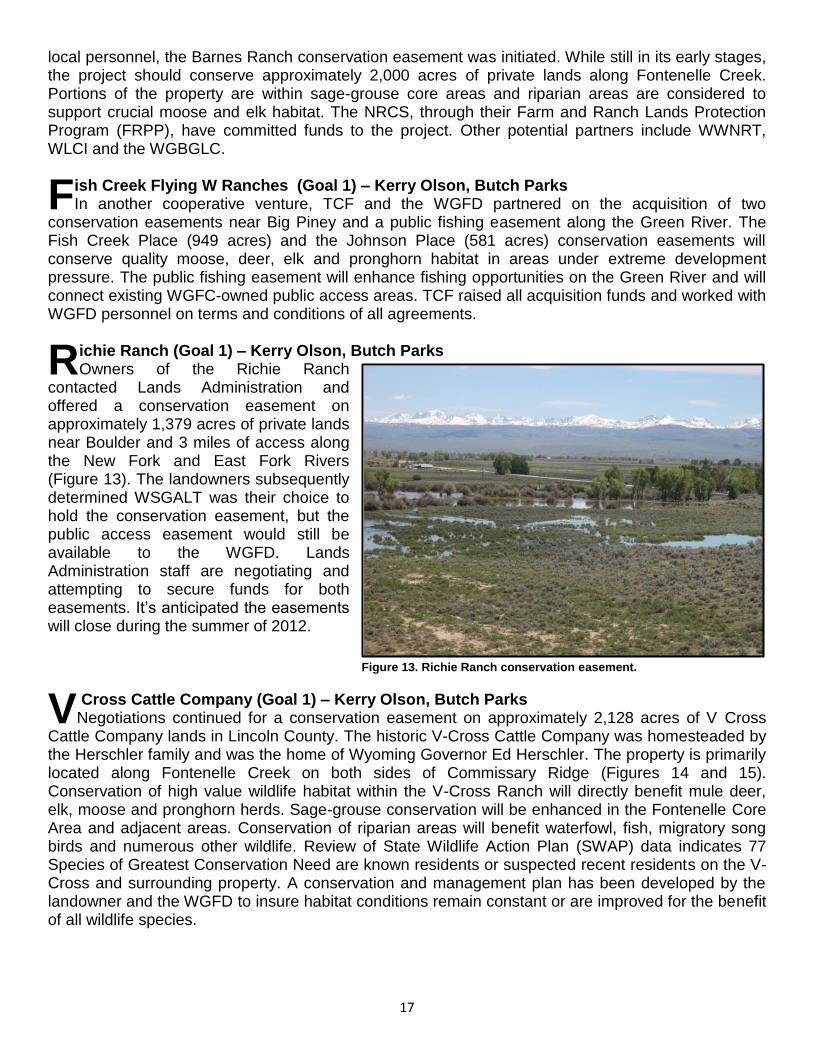
ichie Ranch (Goal 1) – Kerry Olson, Butch Parks Owners of the Richie Ranch
contacted Lands Administration and offered a conservation easement on approximately 1,379 acres of private lands near Boulder and 3 miles of access along the New Fork and East Fork Rivers (Figure 13). The landowners subsequently determined WSGALT was their choice to hold the conservation easement, but the public access easement would still be available to the WGFD. Lands Administration staff are negotiating and attempting to secure funds for both easements. It‟s anticipated the easements will close during the summer of 2012.
Cross Cattle Company (Goal 1) – Kerry Olson, Butch Parks Negotiations continued for a conservation easement on approximately 2,128 acres of V Cross
Cattle Company lands in Lincoln County. The historic V-Cross Cattle Company was homesteaded by the Herschler family and was the home of Wyoming Governor Ed Herschler. The property is primarily located along Fontenelle Creek on both sides of Commissary Ridge (Figures 14 and 15). Conservation of high value wildlife habitat within the V-Cross Ranch will directly benefit mule deer, elk, moose and pronghorn herds. Sage-grouse conservation will be enhanced in the Fontenelle Core Area and adjacent areas. Conservation of riparian areas will benefit waterfowl, fish, migratory song birds and numerous other wildlife. Review of State Wildlife Action Plan (SWAP) data indicates 77 Species of Greatest Conservation Need are known residents or suspected recent residents on the V-Cross and surrounding property. A conservation and management plan has been developed by the landowner and the WGFD to insure habitat conditions remain constant or are improved for the benefit of all wildlife species.
F
R
V
Figure 13. Richie Ranch conservation easement.

18
The project also includes public vehicular access through a portion of the V-Cross that connects with two USFS roads. The landowners have also agreed to allow a parking area on V-Cross lands and foot or horseback access through another portion of their property.
ther Lands Projects (Goal 5) - Kerry Olson and Butch Parks
Developed procedures for organizations to seek WGFD funds for conservation easement projects.
Assisted in the development of the permanent easement for the Darrell Mumm Fishway along Bitter Creek in Park County. The easement allowed construction of permanent fish passage structures on private lands for brown trout, flathead chub, lake chub and longnose dace. See the statewide fish passage section for more information on the fishway.
Evaluated and advanced conservation easement projects on the Boston-Davis Ranch near Casper and the Brigham property near Dubois. Both projects were subsequently cancelled.
Acquired water rights at Bump Sullivan Reservoir and Fremont Lake.
The Angle N Ranch and Pedulla Ranch conservation easement projects were terminated by landowners.
Lands Administration also provided information and met with landowners for several conservation easement projects throughout the state. Property rights and conservation easement discussions were conducted at Regional Leadership Teams in most regions around the state. Meetings with the NRCS, WWNRT, Rocky Mountain Elk Foundation (RMEF), Wyoming Land Trust, WSGALT, Jackson Hole Land Trust, TCF, The Nature Conservancy (TNC), USFS, Bureau of Land Management (BLM), Office of State Lands and Investments (OSLI) and others were attended during the year. Lands personnel remain committed to communicating conservation easement topics and opportunities with landowners, local personnel and others. Once again, Lands Administration received tremendous support and assistance from local personnel, the WGFD‟s Property Rights Team and administration. The WGFC continues to support conservation easements and other property rights projects.
O
Figure 14. V Cross Conservation Easement – Eastern Parcels. Figure 15. V Cross Conservation Easement – Upper Parcels.

19
TERRESTRIAL HABITAT PROGRAM
During 2011, the terrestrial habitat program consisted of eight regional terrestrial habitat biologists (THBs) and four habitat extension biologist (HEBs) working in NRCS District Offices, the terrestrial habitat program manager, the terrestrial habitat assistant program manager and the terrestrial habitat program administrative assistant for a total of 15 permanent FTEs. One temporary position, approximately six months total time, assisted THBs with projects in NW Wyoming. Following retirements, vacating positions to work with other agencies and one position move in 2011, three positions were filled with new employees. The Terrestrial Habitat Section was reconfigured in November 2011 with THB supervision transferred to Regional Wildlife Management Coordinators. The HEBs will remain with the Statewide Habitat Program. Finally, the terrestrial program manager retired and his position will be filled in 2012 and the program administrative assistant opted for a promotion to another WGFD Division in November 2011 and her position is currently vacant. During calendar year 2011, Terrestrial Habitat Section personnel were heavily involved with planning, on-the-ground implementation, oversight or verification of expenditures on 87 projects involving WGFD trust funds. These included WWNRT, USDA Farm Bill Programs and other partners including local, county, state and federal agencies, various NGOs, conservation districts, weed and pest districts and private landowners, among others. These projects amounted to more than $7.6 million in total on-the-ground project expenditures. The various partners and their contributions toward these projects are highlighted in the regional sections of this report. In addition, regional THBs and HEBs worked on other SHP actions that are not directly related to funded projects or are funded through the standard maintenance and operational budget. These actions included habitat protection, inventory and assessment work, monitoring project function and habitat response, habitat related education efforts, training and addressing habitat related opportunities that arise during the year. Lastly, and most importantly, personnel spent a tremendous amount of time planning, coordinating and developing projects with a multitude of partners and preparing funding applications throughout the year. Statewide, THB personnel coordinated with Wildlife Division personnel to address habitat portions of the season setting meetings. They also conducted, coordinated with and collated information collected by Wildlife Division personnel from 87 established annual vegetation production and utilization transects. Another important ongoing task is collecting vegetation and habitat monitoring data on 116 transects associated with past habitat enhancements. HEBs attended area Conservation District and NRCS meetings to promote wildlife habitat management and enhancement projects and USDA Farm Bill programs. Section personnel are also responsible for coordinating annual meetings with federal land management agencies relative to wildlife habitat enhancement projects and larger federal projects that may affect wildlife habitat. They provided assistance at hunter check stations to collect tissues for chronic wasting disease analysis and other biological information from harvested animals and participated in sage-grouse and sharp-tailed grouse lek surveys. Most section personnel also serve on one or more WGFD species working groups (moose, bighorn sheep, sage-grouse, pronghorn and mule deer) and routinely serve on various committees to address an issue or need with habitat implications.

20
WYOMING LANDSCAPE CONSERVATION INITIATIVE
The Wyoming Landscape Conservation Initiative (WLCI) is a long-term science-based effort to assess and enhance aquatic and terrestrial habitats at a landscape scale in southwest Wyoming, while facilitating responsible development through local collaboration and partnerships. In 2011 numerous coordination meetings, field trips and work sessions occurred (more than 16 Local Project Development Team (LPDT) and Executive Committee (EC) meetings alone) to help develop projects and identify LPDT priorities. The WLCI coordination team members met with conservation partners, permittees, landowners and other agencies and entities to coordinate WLCI activities. The WLCI continues to complete the Conservation Action Plan (CAP) begun in late 2009 and has met with most of the partners to address issues identified within the CAP. The US
Geological Survey (USGS) has begun the writing process and USFWS and WGFD personnel have begun the GIS process of narrowing the focus areas using information provided by the LPDTs. The WCLI has had input from the EC as far as the proportion of funding that will be applied to the CAP. The CAP should serve as a guide to all involved with WLCI to address ecological functions throughout the WLCI area; it is anticipated that the CAP will be completed by the summer of 2012. The WLCI helped fund 35 projects in 2011; a number of these projects are multi-year projects that began prior to 2011. Projects within a specific WGFD region are described in the regional sections of this report.
spen Effectiveness Monitoring (Goal 2) - WLCI Aspen communities in the WLCI area are widely disbursed across numerous mountains and
ranges that connect the vast shrub-steppe system separating the northern and southern Rocky Mountains. Because of their wide distribution, the influence and response to change agents to aspen communities is inconsistent. In addition, consistently applied indicators to address change agents and monitor the effectiveness of treatments are lacking. To address the lack or inconsistent application of indicators, we propose to establish ecological indicators associated with aspen communities that are sensitive to change caused by invasive species, altered wildland fire cycles, climate change, energy development and other stressors that can be applied across ecoregions. To accomplish this, some indicators will be used in an assessment that evaluates how the ecological and hydrological settings of aspen communities are affected by different change agents. Other indicators will be selected to be used in an assessment that addresses trends associated with aspen resilience and regeneration potential at treated and untreated aspen stands. Results from each of these assessments will be synthesized and rescaled to inform decisions at local to landscape scales. Application of these indicators and the results of these assessments will be used to prioritize aspen stands for future treatments and evaluate their effectiveness and resilience to stressors and other change agents. Partners include BLM, BTNF, MBNF, WGFD and USGS.
yoming Native Seed Collection (Goal 2) - WLCI This project is intended to provide a source of native seed and plant material and develop and
maintain a supply of native plants seed, vegetative propagules and native seed reserves to assist in providing native plant material and seed for restoration projects. The Chicago Botanical Gardens provides interns to the BLM for the Seeds of Success program. Thirty-two different collections were made during FY2011 collection season.
A
W


