2011-07-20 Planning & Development Committee Meeting Minutes · P23/07/11 Moved: Cr G.L. Engeman...
96
MINUTES of the PLANNING & DEVELOPMENT COMMITTEE MEETING CHAIRMAN: Cr Ian Petersen Held in the Boardroom Town Hall 2 Caledonian Hill, Gympie Qld 4570 On Wednesday 20 July 2011 at 9.00 a.m. Recommendation to be considered for adoption at the General Meeting to be held on 27 July 2011 at 9.00 a.m.
Transcript of 2011-07-20 Planning & Development Committee Meeting Minutes · P23/07/11 Moved: Cr G.L. Engeman...

MINUTES
of the
PLANNING & DEVELOPMENT COMMITTEE MEETING
CHAIRMAN: Cr Ian Petersen
Held in the Boardroom Town Hall
2 Caledonian Hill, Gympie Qld 4570
On Wednesday 20 July 2011 at 9.00 a.m.
Recommendation to be considered for adoption at the General Meeting to be held on 27 July 2011 at 9.00 a.m.

Planning & Development Committee Meeting – 20 July 2011 - 1 -
Gympie Regional Council
PLANNING & DEVELOPMENT Cr I.T. Petersen (Chairman), Crs R.J. Dyne, G.L. Engeman, L.J. Friske, R.A. Gâté,
D.R. Neilson, A.J. Perrett, J.A. Walker & J. Watt.
APPOINTMENTS etc. 9.00 a.m. “In-Committee” 10.00 a.m. Paul McDonald (DERM) Re: Wide Bay Burnett NRM Framework
CONTENTS LEAVE OF ABSENCE......................................................................................................................................... 3
NIL ...................................................................................................................................................................... 3 APOLOGIES ......................................................................................................................................................... 3
NIL ...................................................................................................................................................................... 3 DECLARATION OF INTERESTS BY COUNCILLORS ................................................................................ 3
NIL ...................................................................................................................................................................... 3 CONFIRMATION OF PREVIOUS MINUTES................................................................................................. 3 SECTION 1: STRATEGIC PLANNING MATTERS ....................................................................................... 5
1/1 THEN (OLD LAND OFFICE) AND NOW (AICM) POWER-POINT PRESENTATION THAT ACCOMPANIED THE NOMINATION OF NATIONAL TRUST OF QUEENSLAND HERITAGE AWARD ...................................... 5
SECTION 2: PLANNING APPLICATIONS ..................................................................................................... 7
2/1 DA07355 & DA16601 – REQUEST TO EXTEND CURRENCY PERIOD – MATERIAL CHANGE OF USE – COMMUNITY FACILITY (PLACE OF WORSHIP) AND OPERATIONAL WORK – SITEWORKS, WATER AND SEWER CONNECTION, KERB AND ROADWORKS, CARPARKING AND LANDSCAPING ASSOCIATED WITH DEVELOPMENT OF CHURCH AND SCHOOL – CNR RAMSEY & COPP ROAD, SOUTHSIDE – COPP ROAD GYMPIE GOSPEL TRUST..................................................................................................... 7
SECTION 3: RECONFIGURING A LOT APPLICATIONS......................................................................... 13
3/1 2010–1566 – RECONFIGURING A LOT – SUBDIVISION TO CREATE ONE (1) ADDITIONAL LOT – LOT 38 RP903723 (16 CHARLES PLACE) – M & B MARTIN................................................................ 13 3/2 2011-0884 – RECONFIGURING A LOT – SUBDIVISION TO CREATE ONE (1) ADDITIONAL LOTS OVER LOT 3 RP850472, 159 TAMAREE ROAD, TAMAREE – DEGEN.............................................................. 24 3/3 2010-0539 – RECONFIGURING A LOT – SUBDIVISION TO CREATE 30 LOTS AT 95 MOOLOO ROAD, PIE CREEK - KEELDALE PTY LTD ........................................................................................................ 33
LATE ITEMS ...................................................................................................................................................... 44
1. 2010-0539 – RECONFIGURING A LOT – SUBDIVISION TO CREATE 30 LOTS AT 95 MOOLOO ROAD, PIE CREEK - KEELDALE PTY LTD (SUPPLEMENTARY REPORT) ................................................................ 44

Planning & Development Committee Meeting – 20 July 2011 - 2 -
Gympie Regional Council
SECTION 3: RECONFIGURING A LOT APPLICATIONS......................................................................... 47 3/4 DA16505 – REQUEST TO CHANGE AN EXISTING APPROVAL FOR RECONFIGURING A LOT – SUBDIVISION TO CREATE SEVEN (7) ADDITIONAL LOTS – 61 ELJAYS ROAD, THE PALMS – G. & G. CROCKETT ............................................................................................................................. 47
SECTION 4: PLANNING APPLICATIONS PENDING ................................................................................ 59
4/1 PLANNING APPLICATIONS PENDING .................................................................................................... 59 4/2 DEVELOPMENT APPLICATIONS APPROVED.......................................................................................... 69
SECTION 5: GENERAL MATTERS ............................................................................................................... 72
5/1 BUILDING SUMMARY AND REPORT FOR THE MONTH OF JUNE 2011.................................................... 72 SECTION 6: MATTERS FOR COUNCIL’S INFORMATION..................................................................... 72
NIL .................................................................................................................................................................... 72 LATE ITEMS ...................................................................................................................................................... 73
2. 2010-0860 – MATERIAL CHANGE OF USE SEEKING A PRELIMINARY APPROVAL TO VARY THE EFFECT OF THE LOCAL PLANNING SCHEME FOR INDUSTRIAL AND COMMERCIAL DEVELOPMENT AND RECONFIGURING A LOT – SUBDIVISION TO CREATE FOURTEEN (14) ADDITIONAL LOTS – 168 OLD MARYBOROUGH ROAD, GYMPIE – TIM DEVELOPMENTS PTY. LTD. .......................................... 73
SECTION 7: “IN COMMITTEE” ITEMS...................................................................................................... 94
7/1 COMPLIANCE TEAM AGENDA APPENDIX ............................................................................................ 94 7/2 ALLEGED UNLAWFUL BUSINESSES AT COOLOOLA COVE AND TIN CAN BAY ..................................... 94
SECTION 8: GENERAL BUSINESS................................................................................................................ 94
NIL .................................................................................................................................................................... 94 SECTION 9: ATTACHMENTS......................................................................................................................... 95

Planning & Development Committee Meeting – 20 July 2011 - 3 -
Gympie Regional Council
The meeting opened at 9.00 a.m. PRESENT: Crs I.T. Petersen (Chairman), R.J. Dyne, G.L. Engeman, L.J. Friske, R.A. Gâté,
D.R. Neilson, A.J. Perrett, J.A. Walker & J. Watt. Also in attendance were Mr M. Hartley (Director of Planning & Development),
Ms T.M. Stenholm (Manager Development and Compliance) and Ms K. Sullivan (Minutes Secretary).
Cr J. Watt and Ms T.M. Stenholm were not present when the meeting commenced.
LEAVE OF ABSENCE
Nil
APOLOGIES
Nil
DECLARATION OF INTERESTS BY COUNCILLORS
Nil
CONFIRMATION OF PREVIOUS MINUTES
P23/07/11 Moved: Cr G.L. Engeman Seconded: Cr R.A. Gâté That the Minutes of the Planning & Development Committee Meeting held on 6 July 2011 be taken as read and confirmed.
Carried.

Planning & Development Committee Meeting – 20 July 2011 - 4 -
Gympie Regional Council
COUNCIL IN COMMITTEE
The Chairman advised the meeting that Council was going “Into Committee” to discuss
1. Appointment P24/07/11 Moved: Cr A.J. Perrett Seconded: Cr J.A. Walker That pursuant to the provisions of Section 72 of the Local Government
(Operations) Regulation 2010, Council resolves to close the meeting to the public and move “into committee” to consider the following matter/s:-
1. Appointment Further, that in relation to the provisions of Section 171 of the Local
Government Act 2009, Council resolves that following the closing of the meeting to the public and the moving ‘into committee’ that all matters and all documents (whether in hard copy, electronic, optical, visual or magnetic form) discussed, raised, tabled and/or considered whilst the meeting is closed and ‘in committee’, are confidential to the Council and the Council wishes to keep them confidential.
Carried.
“In-Committee” Appointment attendee entered the meeting at 9.01 a.m. Cr J. Watt entered the meeting at 9.06 a.m. Appointment attendee left the meeting at 9.11 a.m.
COUNCIL OUT OF COMMITTEE P25/07/11 Moved: Cr A.J. Perrett Seconded: Cr J. Watt That proceedings be resumed in Open Council.
Carried. Mr R. Halse (Strategic Planning Officer) entered the meeting at 9.22 a.m.

Planning & Development Committee Meeting – 20 July 2011 - 5 -
Gympie Regional Council
SECTION 1: STRATEGIC PLANNING MATTERS
1/1 Then (Old Land Office) and Now (AICM) power-point presentation that accompanied the nomination of National Trust of Queensland Heritage Award
Re: Minute: P26/07/11 Then and Now power-point presentation of
the Old Land Office From: Planning and Development Directorate File: 6-6-10-0011-07 Date: 13 July 2011 Reference: Nil EXECUTIVE SUMMARY This report is for Council information only. It was suggested at the Heritage Advisory Committee on the 12 July that Council be shown the power-point presentation that accompanied the recent nomination of the Old Land Office, now the AICM building, for a National Trust of Queensland Heritage Award under the category of the Governor’s Heritage Awards. PREVIOUS COUNCIL CONSIDERATIONS
Nil Report: (Strategic Planning Officer – R. N. Halse) 1. INTRODUCTION On the 8 July 2011, Council submitted a nomination to the National Trust of Queensland for the Governor’s Heritage Award for the conservation and adaptive reuse project performed on the Old Land Office. The attached power-point presentation is a Then & Now depiction of the conservation and adaptive reuse project. 2. CONCLUSION In conclusion, the information contained in this report is for Council’s information only.

Planning & Development Committee Meeting – 20 July 2011 - 6 -
Gympie Regional Council
3. STRATEGIC IMPLICATIONS Corporate Plan Outcome 3.5 -‘Recognise and promote the history and heritage of the Gympie Region’.
Operational Plan 3.3 (ii) ‘Community Complexes’
Budget No budget required. The nomination is to be completed in-house. Legal/Statutory Nil Risks No corporate risks identified. 4. CONSULTATION Heritage Advisory Committee 5. ATTACHMENTS Nil
P26/07/11 Moved: Cr J.A. Walker Seconded: Cr D.R. Neilson Recommend that Council acknowledge receipt of this information.
Carried. Mr R. Halse left the meeting at 9.29 a.m. Ms T.M. Stenholm entered the meeting at 9.29 a.m. Cr G.L. Engeman left the meeting at 9.29 a.m.

Planning & Development Committee Meeting – 20 July 2011 - 7 -
Gympie Regional Council
SECTION 2: PLANNING APPLICATIONS
2/1 DA07355 & DA16601 – Request to Extend Currency Period – Material Change of Use – Community Facility (Place of Worship) and Operational Work – Siteworks, Water and Sewer Connection, Kerb and Roadworks, Carparking and Landscaping associated with Development of Church and School – Cnr Ramsey & Copp Road, Southside – Copp Road Gympie Gospel Trust
Re: Minute: P27/07/11 Request to Extend Currency Period for (1)
Material Change of Use – Community Facility (Place of Public Worship) and (2) Operational Work – Siteworks, Water & Sewer Connection, Kerb and Roadworks, Carparking and Landscaping associated with Development of Church and School at Cnr Ramsey & Copp Road, Southside
From: Copp Road Gympie Gospel Trust File/s: DA07355 and DA16601 Date: 28 June 2011

Planning & Development Committee Meeting – 20 July 2011 - 8 -
Gympie Regional Council
Report: (Planning Assistant – K.M. Fuller) 1.0 INTRODUCTION Council is in receipt of two (2) requests to extend the currency period for development located on the corner of Copp and Ramsey Road, Southside, specifically: Material Change of Use – Community Facility (Place of Worship) for a
further period of four years. Operational Work - Siteworks, Water & Sewer Connection, Kerb and
Roadworks, Carparking and Landscaping associated with Development of Church and School for a further period of two years.
2.0 DEVELOPMENT PERMIT HISTORY DA07355 – Material Change Of Use A decision notice was issued by Council on 18 November 2003 (four
year currency period). A request to extend the currency period was lodged on 13 November
2007 requesting a four year extension. This request was reported to Council and approved giving a four year
extension until 18 November 2011. Current request to extend the currency period was lodged on 28 June
2011 requesting a further four year extension.

Planning & Development Committee Meeting – 20 July 2011 - 9 -
Gympie Regional Council
Approved Plans (DA07355 – MCU)

Planning & Development Committee Meeting – 20 July 2011 - 10 -
Gympie Regional Council
DA16601 – Operational Work Decision Notice issued by Council 2 December 2008. A request to extend the currency period was lodged on 17 November
2010 requesting a two year extension.

Planning & Development Committee Meeting – 20 July 2011 - 11 -
Gympie Regional Council
This request was approved, however it was agreed to only extend the
currency period by a further one year until 2 December 2011 given that adjoining land to the north could potentially be developed and their design may have impacted on this development.
Current request to extend the currency period was lodged on 28 June 2011 requesting a further two year extension.
3.0 ASSESSMENT REPORT (a) Applicant’s request:
“We wish to make formal application to extend change of use approval DA07355 by a further 4 years. The reasons for this are as follows: 1. Still raising funds for 1.8mil project GFC has restricted this 2. We hope to build Groundwater rd Church first
(Construction to commence shortly)
We also need to extend Operational Works approval DA16601.” (c) Assessment In reviewing the approval granted and the conditions of development imposed, the proposed development is consistent with current planning scheme and policies within the Rural Zone. Current conditions remain relevant and allow for increased payment of contributions in accordance with rate applicable at time of payment. In addition the grounds submitted by the owner for extension of the approval are considered reasonable. Further, the adjoining land to the north east of the site has now received Operational Work approval and it is considered appropriate for a further extension. It is noted that the Operational Work approval also relates to another Material Change of Use approval over this site for Education or Health Premises (Private School). This permit was issued on 19 June 2007 and has received one extension to the currency period until 19 June 2013.

Planning & Development Committee Meeting – 20 July 2011 - 12 -
Gympie Regional Council
4.0 CONCLUSION A request has been received to extend the currency period for the Material Change of Use and associated Operational Work permits for a further four years and two years respectively. Both permits have previously been granted extensions to the currency period. The grounds provided by the applicant for the extension relate to the global financial crisis and their intention to construct the Groundwater Road church first. Given that the site is located within the Rural zone under Council’s 2005 Planning Scheme and Urban Footprint under the 2010 Draft Wide Bay Burnett Regional Plan it is considered that the use is consistent with the intentions for the area and an extension to the relevant currency periods is reasonable in this instance.
P27/07/11 Moved: Cr D.R. Neilson Seconded: Cr J.A. Walker
Recommend that in relation to the request to change a development application for DA07355 for the purpose of Material Change of Use – Community Facility (Place of Worship) and DA16601 Operational Work - Siteworks, Water and Sewer Connection, Kerb and Roadworks, Carparking and Landscaping associated with Development of Church and School over Lot 1 MPH23344 located at Copp Road Southside, Council: (i) Extend the currency period of DA07355 for a further four (4) years
i.e. lapsing date extended to 18 November 2015). (ii) Extend the currency period of DA16601 for a further two (2) years
i.e. lapsing date extended to 2 December 2013).
Carried. Cr G.L. Engeman returned to the meeting at 9.32 a.m.

Planning & Development Committee Meeting – 20 July 2011 - 13 -
Gympie Regional Council
SECTION 3: RECONFIGURING A LOT APPLICATIONS
3/1 2010–1566 – Reconfiguring a Lot – Subdivision to Create One (1) Additional Lot – Lot 38 RP903723 (16 Charles Place) – M & B Martin
FILE: Minute: P28/07/11 2010-1566 APPLICANT: M & B Martin LANDOWNER: T. M & B. E Martin RPD: Lot 38 RP903723 SITE: 16 Charles Place, Curra PROPOSAL: Reconfiguring a Lot – Subdivision
to Create One (1) Additional Lot EXISTING ZONE: Rural Residential PLANNING AREA: Tiaro LEVEL OF ASSESSMENT: Code SITE AREA: 1 hectare

Planning & Development Committee Meeting – 20 July 2011 - 14 -
Gympie Regional Council
KEY POINT SUMMARY
Reconfiguring a Lot application to create one (1) additional lot. Site zoned Rural Residential, adjoining other Rural Residential blocks. No referral agencies. Site currently has one (1) dwelling house and one (1) domestic
outbuilding. Proposal does not comply with the minimum Rural Residential Lot size
of 6000m2 specified by the Tiaro Shire Council Planning Scheme. Proposed area for Lot 1 - 5500m2 and Lot 2 - 4500m2. Application considered contrary to current planning intentions for Curra. Insufficient planning grounds exist to support the proposal. Reconfiguring a Lot application is in conflict with the provisions of Tiaro
Shire Council’s Planning Scheme and therefore recommended for Refusal.
Reported to the 2 March 2011 Planning & Development Committee Meeting for Refusal.
Withdrawn for further consideration on the request of the applicant see Minute G07/03/11.
No further information in support of the application has been submitted by the applicant.
Original report and recommendation still valid and re-presented to Council for further consideration.
1.0 INTRODUCTION This application was previously reported to Council’s Planning and Development Committee Meeting on 2 March 2011 where it was resolved to: P09/03/11 Moved: Cr R.J. Dyne Seconded: Cr J. Watt
Recommend that Council as Assessment Manger, REFUSE, development application 2010-1566 for Reconfiguring a Lot – Subdivision to Create One (1) Additional Lot over Lot 38 RP903723 at 16 Charles Place, Curra for the following reasons: (i) The proposal conflicts with the Tiaro Shire Council Planning Scheme
2005. (ii) The proposed lots are below the minimum lot size for subdivision within
the Rural Residential Zone. (iii) Approval would likely establish an undesirable precedent for the area. (iv) Approval would impact upon the amenity for the area. (v) The proposal cannot meet the Overall Outcomes For Reconfiguring a Lot
Code.

Planning & Development Committee Meeting – 20 July 2011 - 15 -
Gympie Regional Council
(vi) The required road width of Gleneagles Drive did not take into consideration any further development of the lots on the southern side.
Carried. WITHDRAWN REFER MINUTE G07/03/11
Minute G07/03/11 Refers. G07/03/11 Moved: Cr I. T. Petersen Seconded: Cr J. Watt ‘That the Recommendations of the Planning & Development Committee Meeting held on the 2 March 2011 as presented, be received with the exception of Minute P13/03/11 to be withdrawn and dealt with later in this meeting. Further that Minute P09/03/11 be withdrawn for further consideration at the request of the applicant.’ The application was withdrawn at the request of the applicant and subsequently several extensions to the Decision Making Stage time periods were requested and granted to allow the applicant to hold meetings with Council and to submit further information. 2.0 PREVIOUS REPORT A copy of the previous report is reproduced below Report: (Cadet Planning Officer – P. Meredith)
1.0 The Proposal The application seeks to create one (1) additional Rural Residential lot from an existing 1 hectare lot. The proposed lot sizes are Lot 1 - 5,500m2 and Lot 2 - 4,500m2. Proposed Lot 1 road frontage is 25 metres and will retain existing access to Charles Place. Proposed Lot 1 will retain existing dwelling and domestic outbuilding and the existing septic trenches will be relocated to be contained within the proposed lot. Proposed Lot 2 to gain access to newly constructed road Gleneagles Drive (part of the road network for the St Andrews development) with a road frontage of 44 metres.

Planning & Development Committee Meeting – 20 July 2011 - 16 -
Gympie Regional Council
1.1 Site Description The site has an area of 1 hectare and is generally flat land cleared of major vegetation. The access to the site is within the cul-de-sac of Charles Place and the site currently contains one existing dwelling house and a domestic outbuilding. The site is burdened by electricity easement (EMT K) 10 metres wide and 123 metres in length along the western boundary of the site.

Planning & Development Committee Meeting – 20 July 2011 - 17 -
Gympie Regional Council
Remnant Vegetation mapping exists over the subject site, but given that the site has been cleared of vegetation and the size of the development site is less than 2 ha, the application was not required to be referred to the Department of Environment and Resource Management 1.2 Surrounding Land Uses Allotments along both sides of Charles Place are zoned Rural Residential, as are the properties along Curra Estate Road and Clarkson Drive to the south. 2.0 STATE PLANNING REQUIREMENTS No State Planning Policies were applicable. 3.0 PLANNING SCHEME REQUIREMENTS The application for Reconfiguring a Lot in the Rural Residential Zone was lodged under the Tiaro Shire Council Planning Scheme 2005. Reconfiguring a Lot in the Rural Residential Zone is ‘Code Assessable’ development. The following codes apply to the assessment: Reconfiguring a Lot Code Rural Residential Zone Code Landscape & Buffer Code . 3.1 Reconfiguring a Lot Code The proposal can generally comply with ‘6.81 Specific Outcomes and Probable Solutions for Reconfiguring a Lot Code – Probable Solutions’. However the proposal cannot comply with the following. Column 2 - Probable Solutions (a) (i) Allotments comply with the minimum dimensions for the particular zone listed below: (Rural Residential Min Size 6000m2) (Min Ratio Frontage/Depth 1:4) The proposed development complies with the minimum road frontage required however the proposed lot sizes are well below the minimum required size for Rural Residential Lots and the proposed lots do not meet the minimum requirement for Frontage/Depth of 1:4. Under ‘6.80 Overall Outcomes For Reconfiguring a Lot Code (2) The overall outcomes sought for the Reconfiguring a Lot code’ are:

Planning & Development Committee Meeting – 20 July 2011 - 18 -
Gympie Regional Council
(a) Lots are of a size and dimension suitable for their intended use.
The Tiaro Shire Council Planning Scheme 2005 has deemed the minimum lot size suitable for the Rural Residential Zone is 6000m2. The proposal cannot meet the outcomes as proposed Lot 1 and Lot 2 are well below the minimum lot size. (b) Reconfiguring a lot creates a high level of amenity. The proposal intends to create one (1) additional lot (Lot 2) with an area of 4500m2 with the remaining lot (Lot 1) 5500m2. This significant decrease in lot size will impact upon the developments ability to provide sufficient area for a dwelling and other structures associated with rural residential development, without impacting on the locality’s amenity. Over the proposal site there is an electrical easement (EMT K) that will further restrict the potential building area for a dwelling. Approval of a lot size less than the minimum required would likely establish an undesirable precedent for the area and compromise the ability of the area to meet the desired outcomes for the Rural Residential Zone. (c) Creation of lots which provide a high level of access and transport, a full
range of services, where applicable, provisions of means to maintain and improve the amenity of the locality, and to avoid creating situations which may impact on the efficient functioning of the locality.
The proposal generally meets the outcome for access however in regards to public transport the nearest school bus route is approximately 745 metres from proposed Lot 2. It is noted during the assessment of the required road widths for the St. Andrews development, that the existing lots to the south of Gleneagles Drive were not considered in the assessment as the area of these lots, (10,000m2 approx.) were not considered as having potential for subdivision. An increase in allotments for the area would likely cause an accumulative impact upon the road network and an overall degrading of the locality’s amenity.
The proposal generally meets the outcomes for (d) (e) (f) & (g) of ‘6.80 Overall Outcomes For Reconfiguring a Lot Code - (2) The overall outcomes sought for the Reconfiguring a Lot code’. 3.2 Rural Residential Zone Code The proposal generally meets the overall outcomes for ‘4.13 Overall outcomes for Rural Residential Zone’, however for outcome;

Planning & Development Committee Meeting – 20 July 2011 - 19 -
Gympie Regional Council
‘(a) A residential precinct with high amenity and semi rural atmosphere in which the natural features are maintained’; the proposed non-compliance with the required minimum lot size and minimum frontage to depth ratio added with the further constraint of an electrical easement over the site will impact upon the proposal’s ability to meet this outcome.
3.3 Landscape And Buffer Code Proposal generally complies. Martoo Consulting on behalf of the applicant Michael & Barbara Martin submitted the following information in support of the proposal on 19 January 2011. “Specific Outcome (a)(i) in the Reconfiguring a Lot Code in the 2005 Tiaro Planning Scheme is reproduced in italics below with our assessment following in bold: (a)(i) Allotments are of size dimensions to meet the outcomes for development in the zones in respect of: • sustainability of the productive capacity of rural land - Not applicable; • maintaining the ecological quality of an area - Complies. The existing lot is a rural residential lot currently used for rural residential purposes and there are no significant environmental features known to be located on the site or affecting this development application. The proposed development is expected to maintain the ecological quality of the site and the surrounding area and is not expected to have any adverse environmental impacts; • preserving GQAL for agriculture and animal production - Not applicable; • achieving a safe and pleasant residential environment with green space for the well being of residents. - Complies on the following grounds;- 1. The site benefits from two road frontages and each proposed lot has a
different road frontage with safe access therefore the development will not generate any additional traffic along Charles Place and each proposed lot will have an independent sense of place.

Planning & Development Committee Meeting – 20 July 2011 - 20 -
Gympie Regional Council
2. The site is primarily clear of vegetation and is not subject to any
significant physical constraints therefore the lots contain fully usable area so there is ample area on proposed Lot 2 for the construction of a dwelling house and associated infrastructure in a location that is suitably setback from Curra Estate Road, the boundaries of the lot, and from the existing dwelling houses on adjoining lots including proposed Lot 1. The provision of significant separation distances between the rural residential infrastructure on the proposed lots and adjoining lots will achieve a safe and pleasant rural residential environment and retain sufficient areas of green space for the well being of the residents of the area.
providing a variety of lot sizes for industry (aI/ impacts) and commerce. It is widely acknowledged that where a rural residential lot can be fully utilised a lot area of 4000 square metres is sufficient for the lots to be used for rural residential purposes and to maintain a high level of rural residential amenity. Council has demonstrated its support for the development of rural residential lots below 6000 square metres where appropriate in various localities by approving such subdivision development. In the Curra locality in particular we note that examples of approved lots between 4000 and 6000 square metres include: • 4 Jamie Avenue (Lot 2 on SP207677) - 5000m2 • 8 Jamie Avenue (Lot 1 on SP207677) - 5000m2 • 240 Rodney Road (Lot 2 on SP194656) - 5992m2 • Rodney Road (Lot 2 on SP213094) - 4260m2 • 60 Cliff Jones Road (Lot 1 on SP219583) - 5222m2 • 80 Clarkson Drive (Lot 1 on SP196681) - 5000m2 • 100 Clarkson Drive (Lot 1 on SP208255) - 5000m2 • Atkinson Road (Lot 2 on SP144366) - 5006m2 • 17 to 35 O'Dea Road (Lots 1 to 5 on C4911) - 4047m2 The applicants submit that the site is suitable for subdivision development into a 4500m2 lot and a 5500m lot because it is capable of being fully utilised and benefits from two road frontages (unlike many of the approved lots above) which enables the creation of two regular shaped lots with adequate road frontage and a suitable house site.” The applicant submitted that Council has demonstrated its support for the development of rural residential lots below 6000 square metres in the Curra locality and has provided examples of approved lots between 4000m2 and 6000m2. In response to this information it is noted: 4 & 8 Jamie Avenue, Lot 1 & 2 on SP207677 (each lot 5000m2)
approved on the 6th March 2008 by the Tiaro Shire Council.

Planning & Development Committee Meeting – 20 July 2011 - 21 -
Gympie Regional Council
240 Rodney Road, Lot 2 SP194656 (5992m2) approved on the 26th July
2006 by the Tiaro Shire Council. Not relevant as subdivision resulted in a lot size 8m2 less than minimum required due to site constraints.
Rodney Road, Lot 2 SP213094 approved on the 18th January 2007 by
the Tiaro Shire Council. The original lot was 2 ha in size and was restricted by Remnant Vegetation and a large dam on the site. The Tiaro Shire Council recognised these issues and made allowances for this and approved lot 2 at 4260m2. The non-compliance with the minimum lot size required was a result of the effort to minimize the potential clearing of remnant vegetation and to contain the large dam within the boundaries of proposed lot 1.
60 Cliff Jones Road, Lot 1 SP219583 approved on the 15th October
2008 (5222m2). Applicant originally applied for approval for a lot size of 6100m2. However due to the presence of Remnant Vegetation over proposed lot 2 the Department of Natural Resources and Water (now DERM) as a concurrence agency put a condition for approval that all Remnant Vegetation must be included within proposed lot 2 with a 10mt buffer to the lot boundary. Council approved the subdivision and therefore the non-compliance with the minimum lots size requirements to allow the subdivision to accommodate and comply with the concurrence agency conditions.
80 Clarkson Drive, Lot 1 SP196681. No file found.
100 Clarkson Drive, Lot 1 SP208255 approved on the 20th September
2007 by the Tiaro Shire Council (5804m2). Incorrectly submitted as having a lot area of 5000m2 by Martoo Consulting as part of the supporting information. The Tiaro Shire Council made allowances for site constraints and approved a lot size 196m2 less than the minimum required for the zone. Council made these allowances as the proposed lot shape was considered highly amenable and with dual road frontages exceeding the minimum required, the lot size was deemed acceptable.
Atkinson Road Lot 2 SP144366. No file found.
17 to 35 O’Dea Road Lots 1 to 5 on C4911 (4047m2). These lots were
surveyed in 1899 so are not applicable as supporting information.

Planning & Development Committee Meeting – 20 July 2011 - 22 -
Gympie Regional Council
4.0 CONSULTATION 4.1 Internal (a) Design Department Comments Report: (Design Services Technical Officer – A.C. Walsh) These engineering comments are based on the information submitted by Martoo Consulting to subdivide Lot 38 RP903723, 16 Charles Place Curra, into two (2) lots. FRONTAGE ROADS The proposal plan shows lot 1 using the existing access from Charles Place with lot 2 fronting and gaining access from the newly constructed Gleneagles Drive, which forms part of the road network for the St. Andrews development to the north. When assessing the required road widths for the St. Andrews development, the existing lots to the south of Gleneagles Drive were not considered in the assessment as the area of these lots, (10,000m2 approx.) fell well short of the 12,000m2 required by the Tiaro Shire Planning Scheme to create lots with a minimum area of 6,000m2. This being the case, no lots on the southern side of Gleneagles Drive should be allowed to subdivide with access from the said road. 5.0 CONCLUSION The proposal site is situated within the Rural Residential Zone with the majority of lots in the nearby vicinity being 1 hectare or more in size. An approval for lots that do not meet the required minimum lot size for the zone would likely establish an undesirable precedent for the area and would compromise the ability of the area to meet the desired outcomes for the Rural Residential Zone. The applicant has not provided sufficient planning grounds for non compliance with the planning scheme. There are no physical constraints, infrastructure or environmental issues over the proposal site that would support a reason for not meeting the minimum lot size requirements for the Rural Residential Zone other than the fact that the proposal site is 1 ha in area. The locality’s subdivision was established as a rural residential subdivision with the majority of lots within the locality 1ha or above in size, which assures that wholesale subdivision does not occur. If the minimum lot size for the Rural Residential Zone is relaxed without sound planning reasons it would result in the majority of 1 ha lots within this locality having the potential for
Planning & Development Committee Meeting – 20 July 2011 - 23 -
Gympie Regional Council
subdivision. This potential for subdivision would be at the expense of the surrounding community who thought the town plan guaranteed their amenity and privacy afforded when electing to reside in a Rural Residential Zoned area. With due consideration for the above mentioned information and the non-compliance with the Tiaro Shire Council’s Planning Scheme provisions, the application is recommended for refusal. Further Comments The second extension to the Decision Making Stage ends on the 29 July 2011 and as such the application needs to be considered at this meeting. To date one meeting has been held between the applicant and Council, and a further submission from the applicants Consultants was provided immediately before the Agenda was produced (Refer Attachment 1). The original recommendation is re-presented to Council for further consideration.
P28/07/11 Moved: Cr J. Watt Seconded: Cr R.A. Gâté Recommend that Council as Assessment Manager, REFUSE, development application 2010-1566 for Reconfiguring a Lot – Subdivision to Create One (1) Additional Lot over Lot 38 RP903723 at 16 Charles Place, Curra for the following reasons: (i) The proposal conflicts with the Tiaro Shire Council Planning Scheme
2005.
(ii) The proposed lots are below the minimum lot size for subdivision within the Rural Residential Zone.
(iii) Approval would likely establish an undesirable precedent for the area.
(iv) Approval would impact upon the amenity for the area.
(v) The proposal is contrary to the future planning intentions for the area.
(vi) The proposal cannot meet the Overall Outcomes for the Reconfiguring a Lot Code.
(vii) The required road width of Gleneagles Drive did not take into consideration any further development of the lots on the southern side.
Carried.

Planning & Development Committee Meeting – 20 July 2011 - 24 -
Gympie Regional Council
3/2 2011-0884 – Reconfiguring a Lot – Subdivision to Create One (1) Additional Lots over Lot 3 RP850472, 159 Tamaree Road, Tamaree – Degen
FILE: Minute: P29/07/11 2011-0884 APPLICANT: Degen RPD: Lot 3 RP850472 SITE: 159 Tamaree Road, Tamaree PROPOSAL: Reconfiguring a Lot – Subdivision
to Create One (1) Additional Lot EXISTING ZONE: Rural Residential PLANNING SCHEME: Cooloola LEVEL OF ASSESSMENT: Code SITE AREA: 2.314 Ha

Planning & Development Committee Meeting – 20 July 2011 - 25 -
Gympie Regional Council
KEY POINT SUMMARY Reconfiguring a Lot application to create one (1) additional lot; Proposed Lot 1 is 5352m2 and proposed Lot 2 is 1.77 Ha; Site zoned Rural Residential, adjoining other rural residential blocks (to
the south, east and west) and rural blocks (to the north, However this is within the Forest Ridge Estate) along Tamaree Road and Forest Ridge Drive;
The application is the subject of two prior applications, one (1) which was approved under DA14827 which consequently lapsed, and one (1) which did not make decision making stage under 2010-0248 due to lapsing under statutory timeframes;
The site has remnant vegetation to the rear, however the proposed house site is to be located at a distance exceeding 70 metres from this vegetation, therefore referral to Department of Resource and Environmental Management is not required;
Proposed Lot 1 is below 6000m2 but accommodates all necessary infrastructure for the existing house on this lot;
The proposal is recommended to be approved subject to conditions.
Subject Site
Planning & Development Committee Meeting – 20 July 2011 - 26 -
Gympie Regional Council
Report: (Planning Officer – M. K. Matthews) 1.0 INTRODUCTION 1.1 The Proposal This application seeks to create one (1) additional lot from one (1) existing parcel of land. Existing Lot 3 RP850472 is 2.314 Ha in area. The land is currently zoned Rural Residential within the former Cooloola Shire Council area. Proposed Lot 1 is 5352m2 and proposed Lot 2 is 1.77 Ha. 1.2 Site Description The site is flatter towards the front of the site where the current dwelling and outbuilding are located. Towards the rear of the site, the land starts sloping at approximately 7% before coming to a natural watercourse on adjoining Lot 50 SP223763. Existing site improvements include a dwelling located towards the front of the site, and two outbuildings, one of which is located adjacent to the house, the other is located behind the existing dam in the central portion of the site and will service proposed Lot 2. 1.3 Surrounding Land Uses The subject site is currently zoned Rural Residential and, adjoins other rural residential blocks (to the south, east and west) and rural blocks (to the north, However this is within the Forest Ridge Estate) along Tamaree Road and Forest Ridge Drive. The site is within proximity to the North Coast Railway line and Tamaree Limeworks to the east of the site. 1.4 Previous Approval/Application A Development Approval was granted by Council over the site in February 2007 under DA14287 for one (1) additional lot. This approval lapsed in February 2009 and new landowners lodged an application under 2010-0248 for one (1) additional lot, however this application lapsed due to the applicant not referring the proposal to Department of Environment and Resource Management (DERM) within statutory timeframes. This application lodged under 2011-0884 aims to revive the application process and does not require referral to DERM as the proposed building envelope is more than 70 metres from remnant vegetation. There has been correspondence between the applicant, Council and DERM to confirm this.

Planning & Development Committee Meeting – 20 July 2011 - 27 -
Gympie Regional Council

Planning & Development Committee Meeting – 20 July 2011 - 28 -
Gympie Regional Council
Remnant Vegetation 2.0 PLANNING SCHEME REQUIREMENTS The application was lodged under the Cooloola Shire Planning Scheme 2005. The application is Code Assessable development, and subject to assessment against the relevant provisions of this Planning Scheme including the Gympie Planning Area Code, Reconfiguring a Lot Code, Infrastructure Works Code, Landscaping Code, Conservation Significant Areas Code and Resource Areas Code. The application generally complies with Council’s Planning Scheme provisions in relation to Rural Residential subdivisions. The site has sealed road frontage; is within 500 metres of an existing school bus route, does not have direct access to a Major Arterial or Arterial Road and is within 15 kilometres by road of the Gympie Post Office. The zoning of the site as Rural Residential also addresses the identification of the site as containing Good Quality Agricultural Land. Given the allocated zoning, this issue is considered to have already been addressed by Council. There are, however some items of non-compliance that need to be addressed in relation to the Reconfiguring a Lot Code, notably: Specific Outcome SO-1 requires that all new lots for rural residential purposes are not on a current or potential heavy vehicle route. The site is identified as being a heavy vehicle route.

Planning & Development Committee Meeting – 20 July 2011 - 29 -
Gympie Regional Council
In addressing non-compliance with this Specific Outcome regard is had to the Overall Outcomes in relation to: creating safe communities; providing appropriate levels of access. The access location is at a location whereby there is a wide road reserve area and sight visibility is ample in both directions along Tamaree Road. The recommendation incorporates conditions relating to access and sight visibility requirements to allay any safety concerns brought about by the heavy vehicle route. In regards to noise impacts from the heavy vehicle route, the proposed house site is positioned some 80 metres from Tamaree Road, more removed than many houses along this road. Probably Solution PS-12 identifies a minimum lot size of 6000m2 for new lots in the Rural Residential zone. Proposed Lot 1 is only 5352m2, however contains an existing dwelling, domestic outbuilding and effluent disposal area to service this allotment. Proposed Lot 2 proposes a building envelope in front of an existing dam and domestic outbuilding. The building envelope was changed from that originally proposed in 2010-0248 as a measure of avoiding referral of the application to Department of Environment and Resource Management. A lot size under 6 000m2 was proposed to achieve this, and also acknowledged existing site improvements (ie dam) and the topography of the site. Enforcing compliance with the minimum lot size in this instance is not considered to improve the outcome of the proposal and approval of the development as proposed will not result in a higher possible lot yield for the site. Proposed lot 2 is considered to have low re-subdivision potential given its topography, remnant vegetation and existing and proposed site improvements. The proposal has not been accompanied by a geotechnical report for effluent disposal on lot 2, however sufficient area is considered available to accommodate such. A condition is incorporated into the recommendation requiring submission of this report, to give future purchasers and indication of possible suitable areas for disposal of effluent. 3.0 CONSULTATION 3.1 Internal (a) Design Services Division This department’s requirements have been incorporated into the recommendation.

Planning & Development Committee Meeting – 20 July 2011 - 30 -
Gympie Regional Council
4.0 CONCLUSION The proposal does not comply with Council’s Planning Scheme requirement for minimum lot sizes or that sites for rural residential purposes are not on heavy vehicle routes. The site has been the subject of previous development applications which have lapsed, and the proposal in its current form aims to create an acceptable lot layout to satisfy the requirements of Council and external agencies. It is considered that the proposal is an acceptable lot layout to create one (1) additional rural residential allotment, and that conditions of approval can sufficiently address any concerns in regards to areas of non-compliance.
P29/07/11 Moved: Cr R.A. Gâté Seconded: Cr J. Watt Recommend that Council, as Assessment Manager, APPROVE development application (2011-0884) for Reconfiguring a Lot – Subdivision to Create One (1) Additional Lots over Lot 3 CP850472 located at 159 Tamaree Road, Tamaree subject to the following conditions: Conditions to be Satisfied Prior to Council Signing the Plan of Survey
1. The development shall be generally in accordance with the plan
submitted with the application (Drawing No. DEG080603-301110 drawn by Kim McCarthy Surveys and undated).
2. All outstanding rates or charges levied by Council or expenses that
are a charge over the subject land under any act are to be paid. 3. Infrastructure charges are payable as follows:
Infrastructure Item Equivalent Units Current Amount Rural Residential Roads 10 vte $11 757Parks 1 lot $1 960TOTAL $13 717
but will be subject to indexation annually on 1 July. 4. Access to the proposed lots are to be constructed in accordance with
the requirements of Council’s Infrastructure Works Code – Drawing No. R-15.
5. Access to each lot shall have a minimum visibility of 115 metres in
each direction to the satisfaction of Council’s Chief Executive Officer.

Planning & Development Committee Meeting – 20 July 2011 - 31 -
Gympie Regional Council
6. The whole of the subject land including all approved lots is to be
treated for declared plants and cleared of scrap to the satisfaction of Council’s Chief Executive Officer. On completion of the treatment and clearing the enclosed Notification of Compliance Form is to be completed and lodged with Council.
7. Lot boundaries are to be approved by Council’s Chief Executive
Officer prior to cadastral survey. 8. An agreement is to be entered into with the relevant distribution
entity to provide electricity to all approved vacant lots without any financial encumbrance on future owners of these lots.
9. The applicant shall make suitable arrangements for the provision of
an underground telephone service to the proposed new vacant allotments within the subdivision. Documentary evidence shall be submitted that an agreement has been reached with an authorised supplier for telephone services, prior to the Plan of Survey being sealed by Council.
10. Undertake at no cost to Council, the alteration of any public utility
mains (eg. Electricity, water, sewerage, gas etc.) or other facilities necessitated by the development of the land or associated construction works external to the site.
11. All lots are to be permanently numbered with reflective numbers on
posts to the satisfaction of Council’s Chief Executive Officer. 12. The entrance and driveway for Lot 2 is to be constructed to a 3.0
metre wide 2 coat bitumen 25mm asphaltic concrete or reinforced concrete sealed standard from the gravel shoulder of Tamaree Road to the full extent of the access strip.
13. Any future dwelling house is not to be erected within the access
handle of a hatchet shaped allotment. 14. Prior to commencement of the work, an application for compliance
assessment is to be submitted for the proposed access and driveway for the proposed lot, demonstrating compliance with conditions 5, 6 and 13.
15. Erosion and sediment control measures are to be designed and
provided in accordance with the International Erosion Control Association (Australasia) 2008’s “Best Practice Erosion and Sediment Control for Building and Construction Sites”. The design shall be submitted to Council for approval with condition 15.

Planning & Development Committee Meeting – 20 July 2011 - 32 -
Gympie Regional Council
16. Any plans for operational works, water supply and sewerage works, drainage works and street lighting required by this development permit, are to be surveyed, designed and constructed in accordance with Council’s Infrastructure Works Code.
17. All cleared vegetation is to be suitably processed or removed from the
site at no cost to Council. Prior to the commencement of clearing works on site the preferred means of disposal of cleared vegetation is to be approved by Council’s Chief Executive Officer. The following means of disposal are acceptable, but are not limited to: (i) Processing through a woodchipper. (ii) Disposal for firewood. (iii) Disposal for landscaping. (iv) Transport to alternative site for breaking down materials.
Burning off is not an acceptable means of disposal and will not be approved.
Note: Bulk green waste is no longer accepted at any Council landfill site.
18. Identification markers are to be placed within 1 metre of survey pegs
at corner posts of the property. Markers are to be painted white and be at least 100 millimetres in diameter, 1.2 m high above ground and set at least 450 millimetres into the ground. On completion of placement the enclosed Notification of Compliance Form is to be completed and lodged with Council.
19. (i) A geotechnical report is to be submitted to Council assessing the
adequacy and performance of the existing effluent disposal system on the development site and its location in relation to the proposed lot 1.
(ii) The report is to include recommendations for any upgrading works of the existing system considered necessary or preliminary design for a full replacement.
(iii) Such works recommended by the report are to be carried out by the applicant in accordance with the Plumbing and Drainage Act.
20. A geotechnical report is to be submitted to Council to assess and
confirm the suitability of proposed lot 2 to receive effluent in accordance with the Plumbing and Drainage Act.
21. No clearing of mapped remnant vegetation is to occur on approved
Lot 2 and Council’s rates records will be noted accordingly.
Carried. Cr G.L. Engeman left the meeting at 9.37 a.m.

Planning & Development Committee Meeting – 20 July 2011 - 33 -
Gympie Regional Council
3/3 2010-0539 – Reconfiguring A Lot – Subdivision to Create 30 Lots at 95 Mooloo Road, Pie Creek - Keeldale Pty Ltd
FILE NO: Minute: P30/07/11 2010-0539 APPLICANT: Keeldale Pty Ltd as Trustee RPD: Lot 99 L3733 SITE ADDRESS: 95 Mooloo Road, Pie Creek CURRENT USE OF LAND: Vacant / Grazing PROPOSAL: Reconfiguring a Lot – Subdivision to
Create 30 Lots PLANNING SCHEME: Cooloola Planning Scheme EXISTING ZONE: Rural 2010 Draft WBBSPRP: Rural Living OVERLAYS/NATURAL HAZARDS: Regional Ecosystem Value Area
Natural Waterway & Wetland Areas Good Quality Agricultural Land
APPLICABLE CODES: Rural Planning Area Code Reconfiguring a Lot Code
Infrastructure Works Code Landscaping Code
PUBLIC NOTIFICATION: No (Code Assessable) REFERRAL AGENCIES: DERM (Remnant Vegetation and
Referrable Wetland)

Planning & Development Committee Meeting – 20 July 2011 - 34 -
Gympie Regional Council
KEY POINT SUMMARY Reconfiguring a Lot application to create thirty (30) new rural residential
lots; Site zoned Rural, but designated Rural Living in the DWBBSPRP and is
adjacent to approved rural residential development; Application referred to DERM for remnant vegetation and referrable
wetland matters, and this agency has issued conditional approval; Proposal does not comply with the minimum Rural Residential Lot size
of 6000m2 however is consistent with other development in the area and is subject to higher development standards than those nominated in the planning scheme;
Application recommended for approval subject to conditions to be formulated by the Director of Planning and Development.
Report: (Manager Development and Compliance – T.M. Stenholm) 1.0 INTRODUCTION This application seeks Council’s approval for Reconfiguring a Lot – Subdivision to Create 30 Lots over Lot 99 on L3733 at Mooloo Road, Pie Creek. The proposal indicates this to be the seventh stage of the approved Greendale Downs Estate to the west. 1.1 Site Description The site is located at Mooloo Road, Pie Creek, approximately 9.5 kilometres from the Gympie CBD by road.

Planning & Development Committee Meeting – 20 July 2011 - 35 -
Gympie Regional Council
The site has a frontage to the northern side of Mooloo Road. It is bounded by Pie Creek on the eastern side and Zachariah Creek on the western side and contains vegetation along these creeks. The remainder of the site is unimproved and largely cleared. 1.2 The Proposal The application proposes to reconfigure one lot into 30 lots and new road. Upon lodgement a proposal for only 11 lots was made, however the application was amended in response to Council’s information request and the findings of a more recent finalised flood study. Lot sizes range from 4 000m2 to 6.12 hectares with one (1) hatchet shaped block proposed. New road B allows for a possible future connection of the development with the existing Greendale Downs Estate across Zachariah Creek to the east. The proposed layout is reproduced below.

Planning & Development Committee Meeting – 20 July 2011 - 36 -
Gympie Regional Council
1.3 Surrounding Land Uses Land immediately to the west has been previously developed for rural residential purposes. Surrounding the site to the south and east is generally rural in nature with some small pockets of rural residential development interspersed throughout the area, but centering generally on Pie Creek itself.

Planning & Development Committee Meeting – 20 July 2011 - 37 -
Gympie Regional Council
2.0 STATUTORY REQUIREMENTS 2.1 2010 Draft Wide Bay Burnett State Planning Regulatory Provisions The subject site, and land adjoining to the east, north and west, is included in the Rural Living classification in the DWBBSPRP as shown on the map below.
Rural Living Area of Draft WBBSPRP 2.2 Overall Outcomes / Desired Environmental Outcomes The intent of the rural zone is primarily for rural uses, but it also logically allocates land for future urban, rural residential or other purposes designated in the Strategic Plan or a Development Control Plan. The proposal seeks an expansion of an approved rural residential subdivision over land to the west. The proposed rural residential subdivision seeks to create 30 lots, ranging in size between 4 000m2 and 6.12Ha. Two (2) new roads are proposed to provide access to all of the allotments. Leaving aside that the site is not in the designated Rural Residential Area on the Gympie Zoning Map, the proposal is considered to represent a reasonable and logical extension of approved rural residential development.

Planning & Development Committee Meeting – 20 July 2011 - 38 -
Gympie Regional Council
Zoning Plan Although not explicitly stated in the Scheme, this area is considered suitable for rural residential expansion, as it is on the fringe of Gympie’s existing urban and rural residential area and its large lot sizes are conducive to subdivision into rural residential sized lots. In this sense, the proposal provides a satisfactory and logical use of the land and this approach is now reinforced by the introduction of the Wide Bay Burnett SPRP. 2.3 Overlays / Natural Hazards / State Planning Policies 2.3.1 Conservation Significant Areas
The site is mapped as containing a Natural Waterway and Regional Ecosystem Value Area. The two (2) overlays are limited to the creek area, which bound the development site. These areas are well removed from proposed building envelopes and clearing of vegetation within this area has been prohibited by the Department of Environment and Resource Management in their conditions of approval for the development. 2.3.2 Good Quality Agricultural Land The site is identified on Overlay Map OM8 (Sheet 1) as comprising both Class A and Class B Good Quality Agricultural Land (GQAL). In contemplating the need for expansion of the Gympie Urban Area, Council has to rationalise the need to permit expansion against the knowledge that this would compromise the preservation of some existing conditions, overriding the need to preserve GQAL.

Planning & Development Committee Meeting – 20 July 2011 - 39 -
Gympie Regional Council
As the land immediately adjoining the site to the west has been approved for rural residential activities and the subject site has since been designated as ‘Rural Living’ in the Draft Wide Bay Burnett State Planning Regulatory Provisions expansion of rural residential development in this area is considered appropriate. 2.3.3 Erosion Hazard Different parts of the site are identified in the Very Low to Very High Erosion Hazard Areas as per Natural Hazard Map NHM2 (Sheet 2). This issue has not been formally addressed by the applicant. A standard approval condition requiring the preparation of an Erosion and Sediment Control Plan is to be imposed to reduce potential risk associated with erosion. 2.4 Assessment Against Codes
The applicable Codes include the following: - Reconfiguring a Lot Code - Rural Planning Area Code - Infrastructure Works Code - Landscaping Code
2.4.1 Reconfiguring a Lot Code The proposal has been assessed against the following: 2.4.1.1 Road Design / Network The proposal includes new roads which provide opportunities to link with adjoining land to the east and west of the site. Such linkages will require approval from DERM for operational work within a waterway. 2.4.1.2 Services The site is not currently serviced by reticulated water supply or sewerage. The proposed lot sizes however, are considered of sufficient size and dimension to support on-site water collection and effluent treatment facilities and this is consistent with the Council’s expectations for development of this nature. A Geotechnical Report has not been submitted with the application, however would be included in the conditions of approval. 2.4.1.3 Open Space No open space is proposed as part of this subdivision. It is recommended that a condition be included to require a monetary contribution be paid in lieu of parkland contribution.

Planning & Development Committee Meeting – 20 July 2011 - 40 -
Gympie Regional Council
2.4.1.4 Lot Sizes The provisions for rural allotments include: - Minimum 100 hectares lot size; and - Minimum road frontage of 100m per allotment. The proposal does not meet the minimum lot size of 100 hectares, which aims to preserve rural lands in viable parcel sizes. The smallest of the proposed lots is 4 000m2 and the largest is 6.12Ha. It is nevertheless noted that the existing lot itself does not meet the lot size criteria under the Planning Scheme. The earlier development of Greendale Downs was approved based on the following additional works being proposed and then conditioned as part of the approval: - roads designed in accordance with standards for urban residential
subdivision; - kerb and channel through the entire estate; - underground drainage pipe systems; - traffic calming devices to provide 50km/h speed environment; - underground power; - street trees; - entrance statement; - street lighting. Council previously advised that it supported the reduced lot sizes vide minute P56/08/06. …that the applicant be advised that Council agrees in principle to reduced lot sizes as part of the proposal, based on the works nominated in the application and subject to detailed assessment when the above items have been supplied. Similar lot sizes are proposed for this extension to the development based on the continuation of these development standards and it is again recommended that any approval be conditioned accordingly.
2.4.1.5 Natural Features The site is adjacent to a natural waterway and regional ecosystem area on Council’s overlay mapping. Regional Ecosystem mapping identifies an area of significance adjoining the bordering creeks and conditions issued by DERM require this vegetation to be preserved.

Planning & Development Committee Meeting – 20 July 2011 - 41 -
Gympie Regional Council
2.4.1.6 Impact on Amenity Accepting that the site is suited to rural residential development, the proposed lot sizes allow for sufficient setbacks from adjoining properties and so permit standards of amenity consistent with a rural residential locality. The proposal involves a 30 lot subdivision in a rural area. Given the level of development proposed, it is reasonable to concede that some amenity impacts are inevitable, though they are likely to be of a nature and intensity commonly associated with rural residential development. In effect, the proposed subdivision is likely to extend the impacts already contemplated by the approved subdivision to the west.

Planning & Development Committee Meeting – 20 July 2011 - 42 -
Gympie Regional Council
2.4.1.7 Energy Efficiency Solar access and access to sunlight and breezes is achieved with all of the lots of sufficient size and dimensions to allow most future dwellings a north-facing orientation. 2.4.1.8 Flood / Landslide / Bushfire The site falls to the north towards Zachariah and Pie Creeks, however a flood study submitted with the application identifies suitable building envelopes are available on each proposed lot in accordance with planning scheme requirements. The site is not identified as being subject to bushfire hazard. 2.4.1.9 Site Contamination The site is has not been identified as being on the Environmental Management Register or Contaminated Land Register. 2.5.1 Rural Planning Area Code While the site is in the Rural Planning Area and triggers assessment against the Rural Planning Area Code, it is not relevant to this proposal as the Code does not incorporate any provisions for reconfiguration. 2.6.1 Infrastructure Works Code
The applicant has not provided an assessment against this Code. An
Operational Works application must be submitted prior to the construction of any works. Standard approval conditions should apply.
2.7.1 Landscaping Code The applicant has not provided an assessment against this Code however as the previous approval was granted based on the incorporation of particular design features, including street trees, a landscaping plan for such will need to be assessed at operational work stage. 3.0 OTHER PLANNING CONSIDERATIONS 3.1 Road Contribution Under the new Infrastructure Charges Regime a contribution can be levied by Council equivalent to the previously charged through Planning Scheme Policy 13.

Planning & Development Committee Meeting – 20 July 2011 - 43 -
Gympie Regional Council
4.0 PUBLIC NOTIFICATION The application is code assessable and did not require public notification. 5.0 CONSULTATION 5.1 Internal (a) Design Services Design Services are supportive of the proposal, with the exception of the proposed creek crossings and appropriate conditions will be provided prior to the issue of a decision notice. 5.2 External 5.2.1 Department of Environment and Resource Management The application required referral to this State Agency as a Concurrence (remnant vegetation) and an Advice (referrable wetlands) Agency. DERM have issued conditional approval for the proposal, subject to no clearing of vegetation buffering both Zachariah and Pie Creeks. 6.0 CONCLUSION The application proposes a subdivision of 1 lot into 30 lots and is consistent with the recently documented SPRP and existing approved development in the locality. The application is recommended for approval, however due to SPA time deadlines it is requested the formulation of conditions be delegated to the Director of Planning and Development.
P30/07/11 Moved: Cr J.A. Walker Seconded: Cr L.J. Friske Recommend that this matter be dealt with as part of Late Item 1.
Carried.
Planning & Development Committee Meeting – 20 July 2011 - 44 -
Gympie Regional Council
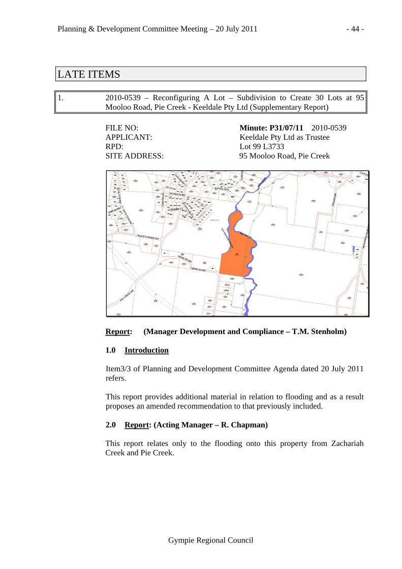
LATE ITEMS
1. 2010-0539 – Reconfiguring A Lot – Subdivision to Create 30 Lots at 95 Mooloo Road, Pie Creek - Keeldale Pty Ltd (Supplementary Report)
FILE NO: Minute: P31/07/11 2010-0539 APPLICANT: Keeldale Pty Ltd as Trustee RPD: Lot 99 L3733 SITE ADDRESS: 95 Mooloo Road, Pie Creek
Report: (Manager Development and Compliance – T.M. Stenholm) 1.0 Introduction Item3/3 of Planning and Development Committee Agenda dated 20 July 2011 refers. This report provides additional material in relation to flooding and as a result proposes an amended recommendation to that previously included. 2.0 Report: (Acting Manager – R. Chapman) This report relates only to the flooding onto this property from Zachariah Creek and Pie Creek.

Planning & Development Committee Meeting – 20 July 2011 - 45 -
Gympie Regional Council
The original Keeldale Development (ie Greendale Downs) was the subject of a Flood Study by consultants, Gilbert and Sutherland, submitted in May 2005. This study very closely mirrored actual flood levels in this area taken from surveyed flood levels taken in Pie Creek immediately after the 1999 flood. As such the flood study was accepted and has been the basis for all works so far approved for this development. The original proposal plan by Martoo Consulting Drawing No. D-01186-01-B for this current application was also based on a more localised flood study in Zachariah Creek by GHD that closely matched the original study. The revised plan now submitted by Martoo Consulting Drawing No. D-01186-01-F that is based on a revised Flood Study undertaken by consulting engineers, Cardno. This study indicates Q100 flood levels that are well below actual levels measured from the 1999 surveyed flood levels thus proposing 19 lots below the 1999 flood. The actual depths of each proposed lot vary with the gradients in the creeks. A review of the Cardno study indicates some assumptions that require further significant justification. For example, Cardno appears to assume bed levels at the bottom of water holes and not sand/rock bars that control creek flow profiles as well as other more technical matters. Council is currently in the process of finalising its own Flood Study for the new Town Plan which includes this area and the investigations into the recorded 1999 flood levels. Whist it is acknowledged the 1999 flood in the Mary River was the third highest recorded, it was calculated as being 3.27 metres below a Q100 flood at Kidd Bridge. There is no known anecdotal evidence regarding Pie Creek flooding to suggest the 1999 flood in Pie Creek was any different. 3.0 Conclusion Given concerns raised with the flooding constraint of the development site it is recommended that only part of the application be approved, being those lots that can provide complying building envelopes above the accepted flood level for this area as identified in the flood study previously prepared by Gilbert and Sutherland. The appropriate alternate resolution is therefore presented to Council.
P31/07/11 Moved: Cr L.J. Friske Seconded: Cr A.J. Perrett Recommend that Council, as Assessment Manager, APPROVE IN PART development application 2010-0539 for Reconfiguring a Lot –Subdivision to Create 30 Lots over Lot 99 on L3733 located at 95 Mooloo Road, Pie Creek, subject to conditions to be determined by the Director of Planning and Development but including the following:

Planning & Development Committee Meeting – 20 July 2011 - 46 -
Gympie Regional Council
1. (i) The plan submitted with the application (Drawing No. D-
01186-01-F drawn by Martoo Consulting and dated 16/08/2010) is approved in part only and is subject to an amended layout that proposes lots with a minimum 1 000m2 building envelope above the accepted flood level in this area as nominated in the Gilbert and Sutherland Flood Study dated May 2005;
(ii) Prior to submission of a development application for operational work amended development plans showing the modification referred to above shall be submitted to Council for consideration and approval. The approved plans, once endorsed by Council’s Chief Executive Officer, shall become part of this Development Permit.
Carried.

Planning & Development Committee Meeting – 20 July 2011 - 47 -
Gympie Regional Council
SECTION 3: RECONFIGURING A LOT APPLICATIONS
3/4 DA16505 – Request to Change an Existing Approval for Reconfiguring a Lot – Subdivision to Create Seven (7) Additional Lots – 61 Eljays Road, The Palms – G. & G. Crockett
RE: Minute: P32/07/11 Request to Change an Existing
Approval for Reconfiguring a Lot – Subdivision to Create Seven (7) Additional Lots – 61 Eljays Road, The Palms – Crockett (Lot 9 RP207511)
FROM: Martoo Consulting for G & G Crockett RPD: Lot 9 RP207511 ADDRESS: 61 Eljays Road, The Palms File: DA16505

Planning & Development Committee Meeting – 20 July 2011 - 48 -
Gympie Regional Council
Report: (Planning Officer – M. K. Matthews) 1.0 INTRODUCTION Development approval for Reconfiguring a Lot – Subdivision to Create Seven (7) Additional Lots was issued on 13 August 2008 as a Preliminary Approval. The applicant then suspended their appeal period and lodged representations in relation to some of the resolutions on 10 September 2008. The applicant provided the information required as part of the Preliminary Approval, namely a geotechnical report addressing the requirements of the Queensland Plumbing and Wastewater Code, clearly demonstrating that all allotments are able to accommodate acceptable effluent disposal areas including details of proposed house sites, proposed effluent disposal areas and exclusion zones; an environmental report detailing the likely impact of the development on the environmental significance of the site and details of any measures proposed to be undertaken to minimise and/or mitigate and adverse impacts; and a bushfire hazard assessment and management plan clearly demonstrating that the development does not result in an unacceptable risk to people or property including details of any measures proposed to be undertaken to minimise and/or mitigate any adverse impacts in the event of a fire. A Negotiated Decision Notice was then issued 22 September 2010 after consideration. The applicant has lodged a Request to Change an Existing Approval to incorporate another three (3) lots, making the proposal for ten (10) additional lots overall.
2.0 REQUEST TO CHANGE
The Request to Change was lodged seeking: (i) endorsement of a new approved plan that incorporates an additional three
(3) lots into the proposal, and four (4) lots below 6 000m2 in area; (ii) staging of the approval; (iii) temporary access arrangements to the balance area created by stage 1;
and (iv) deletion of condition 3.2 relating to potential bushfire hazard risk.

Planning & Development Committee Meeting – 20 July 2011 - 49 -
Gympie Regional Council
Current Approved Plan:

Planning & Development Committee Meeting – 20 July 2011 - 50 -
Gympie Regional Council
Proposed Plan:

Planning & Development Committee Meeting – 20 July 2011 - 51 -
Gympie Regional Council

Planning & Development Committee Meeting – 20 July 2011 - 52 -
Gympie Regional Council
2.1 Applicant’s Supporting Submission ‘The applicant wishes to change the approved plan and submits the enclosed amended Proposal Plan numbered D-C01283-01-C and Staging Plan numbered D-C01283-02-C for Council's consideration. The applicant seeks Council's approval to amend the approved proposal plan to better maintain a wider vegetated corridor between two existing animal habitats and in so doing create a further three (3) additional lots resulting in ten (10) additional lots in total in four (4) stages as shown on the enclosed Proposal Plan numbered D-C01283-01-C and Staging Plan numbered D-C01283-02-C. In addition to the additional lots, Proposal Plan numbered D-C01283-01-C and Staging Plan numbered D-C01283-02-C shows the following variations from approved Proposal Plan numbered D-00774-04-N:
- Proposed lot sizes are between 4227m2 and 1.948ha which reflects the range of lot sizes of rural residential lots in the immediate locality;
- The amended design better utilises the area of non-remnant vegetation on the site by such means as:- o providing a wider corridor between essential habitat areas on
nearby lands to the north and south; o positioning smaller lots on that part of the site which is less
constrained by topography, assessable vegetation, etc. and therefore the majority of the smaller lots can be utilised for rural residential purposes;
o limiting new lot boundaries in those parts of the site that are constrained by topography and required to provide habitat connectivity;
- The New Road has been extended by approximately 40 metres to allow access to the additional lots;
- Proposed Lot 6 is accessed via 11 metre wide, 30 metre long access, handle;
- Truncations to the corners of proposed Lots 1 and 11 and the New Road as required by condition 1.1 (i)(a) of the development permit. Note both truncations are 10 metres in length however a single chord truncation is proposed to the corner of proposed Lot 1 and a three chord truncation is proposed to the corner of proposed Lot 11;
- Building envelopes have been repositioned closer to the New Road frontage of the lots to reduce the overlap of the asset protection zone relative to each building envelope and mapped remnant vegetation on Regional Ecosystem mapping (with the exception of the building envelope for proposed Lot 10 which does not impact on mapped remnant vegetation);

Planning & Development Committee Meeting – 20 July 2011 - 53 -
Gympie Regional Council
- One rear allotment (proposed Lot 6) which better utilises the area of mapped nonremnant vegetation for the building envelope and the asset protection zone within that lot, and also removes the approved allotment boundary between approved Lots 5 and 6, thereby reducing the impact on mapped remnant vegetation and providing an enhanced habitat corridor;
- Four stages of the subdivision: Stage 1: Subdivision of site to create proposed Lots 1, 11 and the balance area; Stage 2: Subdivision of balance area to create proposed Lots 8 to 10 and the balance area; Stage 3: Subdivision of balance area to create proposed Lots 2 to 4 and the balance area; Stage 4: Subdivision of balance land to create proposed Lots 5 to 7.
The following matters are considered relevant to the amended design:
- The boundaries of the new lots have been positioned with due regard for the existing development on the site, the vegetation on the site and that shown on Regional Ecosystem mapping, the need for suitable building sites within each lot, and the need for suitable access to each lot;
- Pre-application meetings were held between Greg Martoo of Martoo Consulting, the applicant and representative, and each of Council and DERM in separate meetings where design preferences were discussed and afterwards incorporated into the amended subdivision layout and staging;
- The applicant has sought to reduce the impact of the proposed development, in comparison to the approved subdivision, on mapped remnant vegetation where possible. Clearing of remnant vegetation will be confined to vegetation located within the building envelopes/asset protection zones and no clearing of remnant vegetation beyond these areas is proposed. Furthermore, the applicant proposes to landscape that area of nonremnant vegetation on proposed Lot 6 beyond the asset protection zone with similar species to the adjoining regional ecosystem;
- The staging of the development is intended to facilitate the staged extension of power supply to the proposed lots as the existing power supply to the existing house on-site currently traverses Lots 8 to 11 from Eljays Road. Also, the applicant may wish to sell proposed Lot 1 after the completion of Stage 1;
- Power supply is presently available for Stage 1. SPECIFIC CHANGES TO EXISTING APPROVAL The applicant requests the following specific changes to the existing development permit:

Planning & Development Committee Meeting – 20 July 2011 - 54 -
Gympie Regional Council
1. Council approve Proposal Plan numbered D-C01283-01-C and Staging Plan numbered DC01283-02-C as the new approved plans and amends the development permit to refer to the new plans;
2. Council amends the development permit to reflect the independent staging of the subdivision;
3. Council allows direct temporary access to Eljays Road from the proposed lots in Stage 1 of the development only. It is proposed that access to the lot comprising the balance area in Stage 1 will utilise a driveway over the access handle of this lot which will be opened as new road in the following stage of the development. It is proposed that the temporary driveway in the access handle (Le. future new road) will be constructed to a gravel standard as any sealed driveway will become redundant works when the new road is opened and roadway constructed in accordance with Council's applicable development codes;
4. Council allows the completion of Stage 1 prior to the lodgment of a development application for Operational Works as required in the current development permit;
5. Council deletes condition 3.2 relating to potential bushfire hazard risk as currently worded and instead amends the Advisory Note (iii) of the development permit to state – Council's rates records for the approved lots will be noted that the lot is included within a bushfire prone area and any buildings on the property should be constructed in accordance with the relevant provisions of the Building Code of Australia that relate to designated bushfire prone areas.
The applicant submits that the Australian Standard AS3959-2009 Construction of buildings in bushfire prone areas is effectively incorporated into the Building Code of Australia and that specific reference to the Australian Standard AS3959-2009 and a minimum construction standard in the development permit is not necessary at this reconfiguring a lot stage of the development. The applicant considers that building construction requirements would be better addressed by building designers/certifiers in the assessment of each Development Application for Building Work at the building stage of the development. With respect specifically to 3.2(ii) to (iv) the applicant submits that the relevant provisions of the Building Code of Australia and the establishment of a 30 metre asset protection zone around each building envelope provides effective management of the potential bushfire hazard risk for each lot and considers that such management requirements in 3.2(ii) to (iv) should not be imposed as a condition of approval as currently worded. STATUTORY REQUIREMENTS In accordance with section 367 of the Sustainable Planning Act 2009, a change to development approval is defined as:

Planning & Development Committee Meeting – 20 July 2011 - 55 -
Gympie Regional Council
(1) A permissible change, for a development approval, is a change to the approval that would not- (a) result in a substantially different development; or (b) if the application for the approval were remade including the
change- (i) require referral to additional concurrence agencies; or (ii) for an approval for assessable development that
previously did not require impact assessment-require impact assessment; or
(c) for an approval for assessable development that previously required impact assessment-be likely, in the responsible entity's opinion, to cause a person to make a properly made submission objecting to the proposed change, if the circumstances allowed; or
(d) cause development to which the approval relates to include any prohibited development.
The proposed change to the approved subdivision is considered to be consistent with the approved subdivision and to comply with the definition for permissible change because the proposed changes to the approval would not: require referral to additional concurrence agencies; change the level of assessment; cause a person to make a properly made submission; or cause the development to include any prohibited development. THE DEVELOPMENT ASSESSMENT Relevant comments in support of the proposed subdivision include:
a) The resulting subdivision of existing Lot 9 on RP207511 into ten (10) additional lots is consistent with the approved subdivision and the applicant does not consider that the amended proposal raises any significant additional issues than those already addressed during assessment of the original development application and at recent pre-application meetings;
b) Notwithstanding that proposed Lots 8 to 11 are below the preferred minimum lot size in the Rural Residential Zone in the 2005 Cooloola Shire Planning Scheme, the size and proportions of these lots are capable of complying with SO-12 for the following reasons: - These lots are of sufficient size and suitable proportions to be
capable of being used for rural residential purposes; - These lots are comprised almost entirely of useable area which
comprises suitable natural surface slopes and is clear of mapped remnant vegetation with the exception only of an area of mapped remnant vegetation along the southern boundary of proposed Lots 8 and 9 which is minor only;

Planning & Development Committee Meeting – 20 July 2011 - 56 -
Gympie Regional Council
- These lots are rectangular in shape and achieve the minimum road frontage of 50 metres, with the exception of proposed Lot 8 which has a road frontage of approximately 43 metres but widens at the rear of the lot to approximately 59 metres and also contains the existing dwelling house, shed and associated infrastructure therefore a 43 metre road frontage for this lot is justified;
- Proposed Lots 9 to 11 each contain a suitable building area which allows suitable separation between house sites, and the existing dwelling house, shed and associated infrastructure on proposed Lot 8 is centrally located within that lot to provide suitably boundary setbacks from such infrastructure;
- These lots sit above Eljays Road and the topography of these lots slopes at a constant gradient uphill to the rear of the site which provides an easterly outlook from each building site.
(c) Council has approved subdivision development of rural residential lots between 4000m2 and 6000m2 in The Palms locality such as: - 140 to 180 Benian Road (6 lots}; - 362 to 408 Jimbour Road (6 lots); - 46, 63 and 64 Kurrajong Drive, 4 and 7 Tea Tree Court, 7
Lillypilly Place (6 lots). d) The proposal is considered to comply, or be capable of complying,
with the specific outcomes and requirements stated in the Gympie Planning Area Code, Reconfiguring a Lot Code, Infrastructure Works Code and Landscaping Code in the current 2005 Cooloola Shire Planning Scheme;
e) The proposed development is not considered to result in additional clearing of mapped remnant vegetation on Regional Ecosystem mapping than that resulting from the approved development, and in fact additional landscaping of a similar regional ecosystem is proposed over an area mapped as non-remnant vegetation;
f) Despite that the site is identified as within a Bushfire Hazard Area, the proposed development is not considered to increase the threat of bushfire to people and/or property in comparison with the approved subdivision.
CONCLUSION The proposed change to the approved development represents suitable development of the site and allows for the staged development of the subdivision and we recommend that Council give this application favourable consideration.’
Planning & Development Committee Meeting – 20 July 2011 - 57 -
Gympie Regional Council
2.2 Assessment Amended Plan The proposal has been approved as a seven (7) lot subdivision with compliant lot sizes and an appropriate internal road layout. The application was approved by the Department of Environment and Resource Management (DERM) under the provision of their governing legislation to the presence of remnant vegetation on site. The applicant has since re-referred this new proposal to DERM and obtained a favourable response from them with conditional approval. The applicant argues that the overall site achieves new lots with an average lot size of greater than 6000m2, however the individual merits of each new allotment under 6000m2 must also be assessed. The applicant also argues support for the proposal on the basis of existing lots within the nearby vicinity that do not comply with the minimum lot size. These are on Benian Road, Jimbour Road and Kurrajong Drive and according to the associated survey plans were registered in 1990, 1993 and 1997 respectively. It is not considered relevant to rely on these existing lots as justification for this development given the date of their creation and the planning scheme changes since. Council has in the past supported the creation of some rural residential lots down to 4 000m2. These proposals have largely been for either planned new estates on large Greenfield sites or the development site has had particular topographical and existing improvement features that warrant the lot sizes proposed. Neither of these arguments are considered to apply to this development. The sub-regional narratives of the 2010 Draft WBBSPRP indicate that “areas of rural residential development that are inappropriately located or subject to unacceptable risks from natural hazards, such as Curra, Widgee and The Palms, are to be restricted from allowing additional rural residential development or the further subdivision of existing allotments”. Further intensification of the existing approved development is contrary to this intent and the future policy direction for the Palms. For the reasons outlined above, the creation of lots below 6 000m2 proposed by the request to change this approval cannot be recommended for approval. Staging and Temporary Access Arrangements The applicant also seeks approval to stage the development and install temporary access to the balance area created by stage 1.

Planning & Development Committee Meeting – 20 July 2011 - 58 -
Gympie Regional Council
Condition 3.1 of the existing approval prohibits direct permanent access being established from lots 1 and 8 onto Eljays Road, with the engineering intention to establish all accesses to the lots from the new internal road. For this reason, part construction of the new road, relative to the frontage of lots 1 and 8 is considered appropriate. Bushfire Requirements Condition 3.2 of the approval states: ‘3.2 The approved lots are located within an identified bushfire prone area
and as such to reduce the potential bushfire hazard risk should be managed as follows:
(i) construction of a Class 1 building must be in accordance with the Australian Standard AS3959-2009 Construction of buildings in bushfire prone areas, with a minimum construction standard of 12.5;
(ii) a minimum 5 000L water supply should be available at all times for the exclusive use of fire fighting. Where stored in a tank, access by emergency services should be facilitated by the installation of a 50mm ball valve and female camlock coupling (or other fitting acceptable to the local fire brigade);
(iii) the dedicated firefighting water supply shall be supported by a petrol or diesel powered firepump (or electric pump powered by an adequate generator); and
(iv) landowners should prepare an Emergency Management Plan for the property including actions to be taken when fire is in the area, as fire arrives at the property, and after the fire passes.’
This condition was formulated following independent advice from a bushfire expert, given Council concerns with the site’s location adjoining State Forest and the bushfire hazard classification allocated to the area. The site’s location at the end of a cul-de-sac with only one (1) possible escape route from the area was also a concern. The requirements conditioned would not normally be considered in an application for building work and are considered more relevant considerations at the subdivision stage. They relate to management of the entire site and are enforceable conditions for the lots’ ongoing use. The bushfire expert also indicated that the construction standard applied by building certifiers can vary under the Australian Standard, hence the desire to specify an appropriate classification through part (i) of the condition. It is recommended that this condition not be deleted.

Planning & Development Committee Meeting – 20 July 2011 - 59 -
Gympie Regional Council
P32/07/11 Moved: Cr A.J. Perrett Seconded: Cr D.R. Neilson
Recommend that Council note that this item has been withdrawn from the Agenda at the request of the applicant.
Carried. Cr G.L. Engeman returned to the meeting at. 9.45 a.m.
SECTION 4: PLANNING APPLICATIONS PENDING
4/1 Planning Applications Pending
NOTE: New Applications are in BOLD AND ITALICS
Abbreviations: AN Acknowledgment Notice AL Acknowledgement Letter RFI Request for Further Information DMS Decision Making Stage DN Decision Notice ADN Amended Decision Notice NDN Negotiated Decision Notice ALOD Adjoining Land Owners Details PN Public Notification PNS Public Notification Stage SP Survey Plan
File Number &
Applicant Location Nature of Application Status
MATERIAL CHANGE OF USE – IMPACT ASSESSMENT DA17897 Morris (MKM)
7-9 Power Road, Southside
Education or Health Premises (School Age Facility)
RFI sent 03/03/08. Awaiting applicant’s response. Proposal plan received 13/10/08. (In conjunction with DA13664)
DA253 Allen & Dray (MKM)
Dray Road, Widgee
Extractive Industry (Rock Quarry) & ERA # 20
DMS. Application on hold pending applicant’s advice.
2009-1859 Christensen (MKM)
14 Glastonbury Road, Southside
2 x Two (2) Storey Town Houses & 2 x Two (2) Unit Apartments
DMS. Report to P&D Committee Meeting. (1) Submission.
2010-0827 Gear Family Investments Pty Ltd (MKM)
6A Parsons Road, Gympie
Multi-Residential (Nine (9) Units)
DMS. DN due.

Planning & Development Committee Meeting – 20 July 2011 - 60 -
Gympie Regional Council
File Number & Applicant
Location Nature of Application Status
2010-0860 Tim Developments Pty Ltd (MKM)
168 Old Maryborough Road, Gympie
COMBINED Preliminary Approval (Industrial & Commercial Development) & Subdivision to Create 18 Additional Lots
DMS. DN due.
2010-0891 Roberts Bros Pty Ltd (TMS)
600 Bruce Highway, Chatsworth
Preliminary Approval to Effect the Local Planning Scheme
Application on hold till 30/12/11. DTMR rfi issued 15/07/10 & DIP rfi issued 05/07/10.
2010-1030 White (LF)
28 Smyth Street, Gympie
Multi-Residential Four (4) Units
RFI sent 09/08/10. Applicant’s response time extended until 09/08/11. Concurrence Agency DTMR rfi issued 27/07/10.
2010-1348 Newman (TMS)
149 Tagigan Road, Goomboorian
Food or Entertainment Venue (Function Venue)
DMS. Report to P&D Committee Meeting. (11) Submissions. One (1) Petition. Further supporting information received 26/05/11.
2010-1351 Medialoco (LF)
29A Shields Street, Gympie
Multi-Residential - Three (3) Dwelling Units
PNS. ALOD sent 07/07/11.
2010-1870 Canty (TMS)
Bella Creek Road, Bella Creek
Accommodation Premises (Camping & Cabins) Food or Entertainment Venue (Multi Sports Park & Kiosk) and ERA #63 Sewage Treatment (2) (a) 21ep to 100ep Premises)
ALOD sent 12/07/11. Concurrence Agencies DERM rfi issued 10/05/11, DTMR response received 16/03/11 & DIP rfi issued 19/01/11. Advice Agency DERM rfi period extended until 12/05/11.
2010-1921 Nargoon Cattle Co (LF)
Old Boonara Road, Cinnabar
MCU - Intensive Animal Husbandry (Increasing Existing 100 to 499 SCU Feedlot) & ERA #2(1)(b) Intense Animal Feed Lotting Cattle 150-1000scu
PNS ALOD to be issued.
2010-2019 G & G Securities (TMS)
Cootharaba Road, Gympie
Seeking a Preliminary Approval Varying the Effect of the Local Planning Instrument
DMS on hold till 31/12/11.
2010-2055 Anderleigh Enterprises Pty Ltd (MKM)
270 Sorensen Road, Gunalda
Extractive Industry & ERA # 16 Extractive and Screening Activities, 2 (c) 100,000 to 1,000,000 Tonnes Per Annum
PNS. Submissions due 03/08/11. DERM ext rfi period 10/08/11.
2010-2014 Monkira Dev P/L AFT Tilt Family Trust (LF)
3 & 7 Flynn Road, Gympie
COMBINED MCU - Multi-Residential (23 Dwelling Units) & RAL – Boundary Realignment.
Reported to P&D Committee Meeting 06/07/11. Ten (10) Submissions.

Planning & Development Committee Meeting – 20 July 2011 - 61 -
Gympie Regional Council
File Number & Applicant
Location Nature of Application Status
2011-0154 Tamaree Developments Pty Ltd (TMS)
Tamaree, Garowme & Cloey Roads, Tamaree
Preliminary Approval to Vary the Effect of the Planning Scheme for an Industrial Development
PNS. Submissions due 22/07/11. Concurrence Agency DIP rfi issued 05/05/11. DLGP response received 09/06/11.
2011-0193 Pakrat Pty Ltd (LF)
31 Scrub Road, Gunalda
Commercial Facility (Showroom - Hardware Store)
PNS. Submissions due 28/07/11.
2011-0657 Singtel Optus Pty Ltd C/- Daly International (SAC)
Western Creek Road, Imbil
Public Utility (Telecommunications Facility)
AN issued 03/06/11. RFI issued 01/07/11. Awaiting applicant’s response. Concurrence Agency DERM response received 27/06/11.
2011-0673 Boyce (KMF)
185 Spencer Road, Kilkivan
Animal Keeping (Dog Kennels)
AN issued 06/06/11. RFI issued 05/07/11. Awaiting applicant’s response.
2011-0745 Delgos (LF)
8 Crown Road, Gympie
COMBINED - Multi-Residential (4 Units) & Preliminary Approval for Building Work Assessable against the Planning Scheme (Removal of Character Building)
AN to be issued. RFI due.
2011-0744 Victory Church (LF)
173-175 Old Maryborough Road, Araluen
Multi-purpose Hall AN to be issued. RFI due.
2011-0878 Curra Country Sandstone Supplies (LF)
Gardners Lane, Curra
Extractive Industry (Sandstone Quarry) & ERA #20 (Extracting rock, sand, clay, gravel, loan or other material <5000t per annum)
AN issued 07/07/11. RFI due.
MATERIAL CHANGE OF USE – CODE ASSESSMENT DA16074 Go West Gympie Pty Ltd (MKM)
27 Louisa Street, Gympie
General Industry (Motor Vehicle Workshop & Environmentally Relevant Activity ERA #28 – Motor Vehicle Workshop)
Part RFI response received 16/12/10.
DA17123 Wilson (MKM)
26 Burns Road, Ross Creek
Accommodation Premises (Farm Cabins)
Letter sent 08/10/10 requesting intentions to finalise.
2009-0893 The Clayton Family Superannuation Fund (TMS)
Chapple Street, Gympie
Display Yard (Construction Equipment for Sale, Hire and Lease)
DMS. DN due. Additional information received 08/11/10.

Planning & Development Committee Meeting – 20 July 2011 - 62 -
Gympie Regional Council
File Number & Applicant
Location Nature of Application Status
2009-1648 Reyloh (KMT)
17,19,21, & 23 Oak Street and 22 Chatsworth Road, Gympie
Accommodation Premises (84 Motel Units and Caretaker’s Residence) and Food or Entertainment Venue (Restaurant and Function Room)
Applicant negotiating with DTMR.
2009-2130 CJ Black Medical Pty Ltd aft CJ Black Investment Trust (LF)
63 King Street, Gympie
COMBINED – MCU - Multi-Residential Six (6) Units & RAL - Subdivision to Create One (1) Additional Lot
Reported to P&D Committee Meeting 20/04/11. Additional information received 19/05/11.
2010-1209 Gympie Regional Council (TMS)
Bayside Road, Tin Can Bay
Public Utility (Waste Transfer Station) & ERA # 62 (Waste transfer station operation)
RFI response received 14/06/11. Concurrence Agency DERM (ERA).
2010-1553 I3 Consulting (MKM) (eDA)
3 Langton Road, Monkland
General Industry (Commercial showroom for the sale of building and hardware products)
Reported to P&D committee Meeting 06/07/11.
2010-1520 Building Suncoast Green (LF)
18 Brisbane Road, Gympie
COMBINED MCU - General Industry (Tyre Fitting Workshop) & OW - (Stormwater, Earthworks, Landscaping & Driveway)
RFI response due 18/11/11. Part response received 05/01/11. Concurrence Agency DTMR rfi issued 05/11/10.
2010-1649 AJ & DA Corbet ATF AJ & DA Corbet Family Trust (MKM)
20 Barter Street, Gympie
Commercial Premises (Professional Offices)
DMS. DN due. Letter sent 06/07/11. Response due 15/07/11.
2010-1752 Morrison (MKM)
2 Stanley Street, Gympie
Multi-Residential (Seven (7) Units in Two (2) Stages
RFI issued 15/12/10. Awaiting applicant’s response. Concurrence Agency DTMR response received 09/12/10.
2010-1765 Gympie Regional Council (TMS)
Bonnick Road, Gympie
Public Utility – (Expansion of Waste Management Facility)
RFI response received 13/05/11. Concurrence Agency DERM rfi sent 27/01/11.
2010-2026 AHC Ltd (TMS)
5 Woolgar Road, Southside
Commercial Premises (Service Station & Shop)
RFI sent 17/02/11. Awaiting applicant’s response. Concurrence Agency DTMR response received 01/03/11.
2011-0124 Peskops (TMS)
355 Sterling Road, Kandanga Creek
Intensive Animal Husbandry - Piggery (Free Range Pig Farm) and ERA#3 (1) Pig Keeping - Keeping 20 - 400 standard pig units
DMS. Report to P&D Committee Meeting.
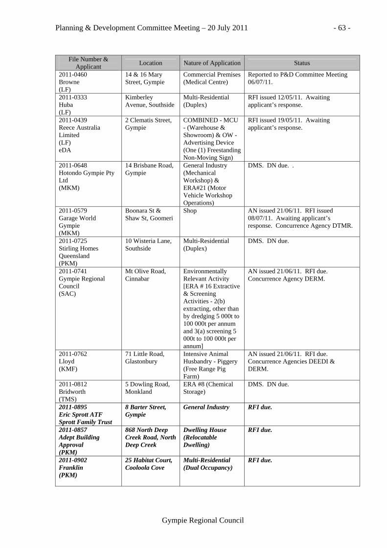
Planning & Development Committee Meeting – 20 July 2011 - 63 -
Gympie Regional Council
File Number & Applicant
Location Nature of Application Status
2011-0460 Browne (LF)
14 & 16 Mary Street, Gympie
Commercial Premises (Medical Centre)
Reported to P&D Committee Meeting 06/07/11.
2011-0333 Huba (LF)
Kimberley Avenue, Southside
Multi-Residential (Duplex)
RFI issued 12/05/11. Awaiting applicant’s response.
2011-0439 Reece Australia Limited (LF) eDA
2 Clematis Street, Gympie
COMBINED - MCU - (Warehouse & Showroom) & OW - Advertising Device (One (1) Freestanding Non-Moving Sign)
RFI issued 19/05/11. Awaiting applicant’s response.
2011-0648 Hotondo Gympie Pty Ltd (MKM)
14 Brisbane Road, Gympie
General Industry (Mechanical Workshop) & ERA#21 (Motor Vehicle Workshop Operations)
DMS. DN due. .
2011-0579 Garage World Gympie (MKM)
Boonara St & Shaw St, Goomeri
Shop AN issued 21/06/11. RFI issued 08/07/11. Awaiting applicant’s response. Concurrence Agency DTMR.
2011-0725 Stirling Homes Queensland (PKM)
10 Wisteria Lane, Southside
Multi-Residential (Duplex)
DMS. DN due.
2011-0741 Gympie Regional Council (SAC)
Mt Olive Road, Cinnabar
Environmentally Relevant Activity [ERA # 16 Extractive & Screening Activities - 2(b) extracting, other than by dredging 5 000t to 100 000t per annum and 3(a) screening 5 000t to 100 000t per annum]
AN issued 21/06/11. RFI due. Concurrence Agency DERM.
2011-0762 Lloyd (KMF)
71 Little Road, Glastonbury
Intensive Animal Husbandry - Piggery (Free Range Pig Farm)
AN issued 21/06/11. RFI due. Concurrence Agencies DEEDI & DERM.
2011-0812 Bridworth (TMS)
5 Dowling Road, Monkland
ERA #8 (Chemical Storage)
DMS. DN due.
2011-0895 Eric Sprott ATF Sprott Family Trust
8 Barter Street, Gympie
General Industry RFI due.
2011-0857 Adept Building Approval (PKM)
868 North Deep Creek Road, North Deep Creek
Dwelling House (Relocatable Dwelling)
RFI due.
2011-0902 Franklin (PKM)
25 Habitat Court, Cooloola Cove
Multi-Residential (Dual Occupancy)
RFI due.

Planning & Development Committee Meeting – 20 July 2011 - 64 -
Gympie Regional Council
File Number & Applicant
Location Nature of Application Status
2011-0892 Oakvale Homes Building Group P/L (PKM)
504 Curra Estate Road, Curra
Dwelling RFI due.
2011-0908 Cooloola Building Approvals (PKM)
51 Investigator Avenue, Cooloola Cove
Multi-Residential (Second Dwelling)
RFI due.
2011-0916 Poinciana Grove Pty Ltd (KMF)
Ranson 7 Andrew Street, Gympie
Dwelling houses over 12 approved lots
RFI due.
RECONFIGURING A LOT – IMPACT ASSESSMENT 2008-1098 Allen-Co Holdings Pty Ltd (SAC)
2110 Gympie Woolooga Road, Widgee
Subdivision to Create 67 Lots in Two (2) Stages
RFI sent 11/11/09. Awaiting applicant’s response. Concurrence Agencies DTMR rfi issued 20/08/10. DERM (VMA) rfi issued 06/09/10 & DERM (EPA-clu) rfi issued 06/09/10.
2011-0534 Ahern James Naismith Pty Ltd (LF)
Upper Widgee Road, Widgee
Subdivision to Create One (1) Additional Lot
DMS. Report to P&D Committee Meeting. One (1) Submission.
2011-0697 Parsons (KMF)
Rossmore Road, Kilkivan
Boundary Realignment
PNS. Submissions due 22/07/11.
RECONFIGURING A LOT DA03663 Andreassen (TMS)
Ballard Road, Imbil
Development Permit – Stage 6 (3 Lots) and Stage 7 (18 and Balance)
DMS. Report to P&D Committee Meeting.
DA14342 Christensen (MKM)
16-18 Glastonbury Road, Southside
Subdivision to Create One (1) Additional Lot
DMS. Report to P&D Committee Meeting. Letter sent to DTMR 14/04/10. Awaiting response.
SD518 Hawkins (LF)
Hawkins Road Widgee
Boundary Realignment
Letter sent requesting intentions to finalise by 19/05/11.
2008-1187 Gympie Regional Council (MKM)
Scullett Drive, Tin Can Bay
Subdivision to Create 14 Additional Industrial Lots
Response to RFI received 24/06/09. Referral Agency DMR rfi issued 23/03/09. Advice Agency Energex response received 20/03/09.
2009-2002 O’Leary & Pearman (SAC)
Glastonbury Road, The Palms
Subdivision to Create Twenty Four (24) Additional Lots
DERM & DTMR responses received. RFI sent 19/07/10. Awaiting applicant’s response.
2010-0428 Bay Survey Consultants (KMF)
Langton Road, Monkland
Subdivision to Create Eleven Additional Lots
Amended AN & RFI issued 26/08/10. Awaiting applicant’s response (due 28/07/11). Concurrence Agency DTMR response received 01/10/10. Concurrence & Advice Agency DERM (CLU & Heritage) response received 04/11/10.
2010-0539 Keeldale Pty Ltd (TMS)
95 Mooloo Road, Pie Creek
Subdivision to Create 29 Additional Lots
DMS. Report to P&D Committee Meeting. Refer to Item 3/3 in Today’s Agenda.

Planning & Development Committee Meeting – 20 July 2011 - 65 -
Gympie Regional Council
File Number & Applicant
Location Nature of Application Status
2010-1566 Martin (PKM)
16 Charles Place, Curra
Subdivision to Create One (1) Additional Lot
DMS. Report to P&D Committee Meeting. Refer to Item 3/1 in Today’s Agenda.
2010-1730 Murray & Associates (QLD) Pty Ltd (TMS) (eDA)
600 Bruce Highway, Chatsworth
Subdivision to Create Nineteen (19) Additional Lots
RFI response received 07/07/11. Concurrence Agency DTMR. (related file DA15764)
2010-1977 Hess (TMS)
Briere Road, The Palms
Subdivision to Create (1) One Additional Lot
Reported to P&D Committee Meeting 15/06/11.
2010-2058 Dickinson (TMS)
308 Carlo Road, Rainbow Beach
Subdivision to Create (45) Additional Lots
RFI issued 14/02/11. Concurrence & Advice Agency DERM rfi issued 14/02/11.
2011-0032 Moore (LF)
208 Brisbane Road, Monkland
Subdivision to Create Three (3) Additional Lots
DMS. DN due.
2011-0152 Dunn (MKM)
25 Samantha Drive, Pie Creek
Subdivision to Create One (1) Additional Lot
RFI issued 16/03/11. Awaiting applicant’s response.
2011-0169 Burke (LF)
590 Noosa Road, Mothar Mountain
Subdivision to Create Seven (7) Additional Lots
DMS. Report to P&D Committee Meeting.
2011-0198 Snow (SAC)
383 Nash Road, Tamaree
Subdivision to Create Six (6) Additional Lots
DMS. DN due.
2011-0230 MacKay (LF)
343 Hyland Road, East Deep Creek
Subdivision to Create (2) Additional Lots in Two (2) Stages
RFI issued 17/03/11. Awaiting applicant’s response.
2011-0259 Smillie (LF)
38 Trout Road, The Dawn
Subdivision to Create Two (2) Additional Lots and Access Easement
AN issued 24/03/11. RFI issued 28/04/11. Concurrence Agency DTMR. DTMR rfi issued 12/04/11.
2011-0379 Partington (SAC)
81 Donald Drive, Curra
Subdivision to Create Two (2) Additional Lots
RFI issued 17/05/11. Awaiting applicant’s response.
2011-0331 Resland Management (Aust) Pty Ltd (KMF)
Ranson Road, Gympie
Subdivision to Create (3) Three Additional Lots
RFI issued 20/04/11. Awaiting applicant’s response.
2011-0274 DTS Group (KMF)
80 Howe Road, Traveston
Access Easement AN issued 07/04/11. RFI not required. Concurrence Agency DTMR rfi issued 11/05/11, Advice Agency Energex response received 09/05/11.
2011-0450 Greenco Developments Pty Ltd (SAC)
1 Pinewood Avenue, Gympie
Boundary Realignment
RFI issued 28/04/11.
2011-0552 Bryers (PKM)
10 Billabong Court, Pie Creek
Subdivision to Create Two (2) Additional Lots
RFI sent 01/06/11. Awaiting applicant’s response.
2011-0578 Moir (SAC)
11 Kauri Court, Chatsworth
Subdivision to Create Three (3) Additional Lots
RFI issued 31/05/11. Awaiting applicant’s response.

Planning & Development Committee Meeting – 20 July 2011 - 66 -
Gympie Regional Council
File Number & Applicant
Location Nature of Application Status
2011-0577 Kaye (MKM)
103 Donald Drive, Curra
Subdivision to Create Two (2) Additional Lots
DMS. DN due.
2011-0590 Jones, Condon & Mallon (LF)
62 Noosa Road, Monkland
Subdivision to Create 21 Additional Lots
RFI issued 09/06/11. Awaiting applicant’s response. Advice Agency Energex response received 17/06/11.
2011-0611 Ahern James Naismith (Gympie) (KMF)
287 Marys Creek Road, Marys Creek
Subdivision to Create Two New Lots from Two Existing Lots
RFI sent 03/06/11. Awaiting applicant’s response.
2011-0654 Drollinger (LF)
126 Tamaree Road, Tamaree
Subdivision to Create One (1) Additional Lot
AN issued 02/06/11. RFI not required. Concurrence Agency DERM.
2011-0635 Chandler (PKM)
Glen Echo Road, Glen Echo
Subdivision to Create One (1) Additional Lot
DMS. DN due.
2011-0670 Downunder Properties Pty Ltd (LF)
Tin Can Bay Road, Tin Can Bay
Subdivision to Create (10) Additional Lots
AN issued 20/06/11. Concurrence Agency DERM & DTMR. Advices Agency DERM & Energex.
2011-0746 Treloar (MKM)
26 Holding Road, The Dawn
Subdivision to Create One (1) Additional Lot
DMS. DN due.
2011-0778 Walker (MKM)
27 Pine Street, Gympie
Subdivision to Create Two (2) Additional Lots
RFI issued 23/06/11. Awaiting applicant’s response.
2011-0856 Alexander (SAC)
72 Old Veteran Road, Veteran
Subdivision to Create (1) Additional Lot
RFI issued 30/06/11. Awaiting applicant’s response.
2011-0835 Watson (PKM)
65 Quinlan Road, Tamaree
Subdivision to Create (1) Additional Lot
RFI issued 01/07/11. Awaiting applicant’s response.
2011-0863 Pagerose Pty Ltd (PKM)
Carnoustie Court, Curra
Boundary Realignment
RFI sent 06/07/11. Awaiting applicant’s response.
2011-0876 Aspinall (SAC)
Jimbour Road, The Palms
Subdivision to Create Four (4) Additional Lots
AN to be issued. RFI due. Advice Agency DERM.
2011-0884 Degen (MKM/TMS)
159 Tamaree Rd, Tamaree
Subdivision to Create One (1) Additional Lot
RFI due. Refer to Item 3/2 in Today’s Agenda.
2011-0901 Penn (PKM)
North Deep Creek Road, North Deep Creek
Boundary Realignment
RFI due.
2011-0967 Kelly (LF)
108 Robert Road, Chatsworth
Subdivision to Create One (1) Additional Lot
RFI due.
OPERATIONAL WORK (Including Combined Building/Plumbing and Operational Work) DA13337 Wagner (TMS)
391 Bruce Highway North, Two Mile
Earthworks Part response to RFI received 07/08/09.

Planning & Development Committee Meeting – 20 July 2011 - 67 -
Gympie Regional Council
File Number & Applicant
Location Nature of Application Status
DA13568 Crampton (TMS)
10 Mitchell Street, Tin Can Bay
Site Works, Driveway Access, Carparking & Landscaping
DMS. DN due.
DA15865 Zerner (MKM)
8 Wadell Road, Two Mile
Driveways, Stormwater Drainage, Retaining Wall, Carparking & Earthworks)
DMS. DN due.
2008-1400 Millers (TMS)
2 Tucker Street & 20 Chapple Street, Gympie
Roadworks, Stormwater, Landscaping & Earthworks
Letter sent requesting intentions. Response due 30/06/11.
2008-1682 Lohage (LF)
Ian Drive, Curra Dam RFI sent 10/12/08. Awaiting applicant’s response.
2009-1438 Opus Qantec McWilliam (TMS)
Old Imbil Road, Monkland
Roadworks, Stormwater Drainage, Water and Sewerage Infrastructure
DMS. DN due.
2010-1259 AECOM (TMS)
Queen Elizabeth Drive, Cooloola Cove
Landscaping for Approved Subdivision.
DMS. DN due.
2010-2060 Ken Hudson & Associates (LF)
Valley Vista Road, The Dawn
Roadworks, Drainage Works, Stormwater & Earthworks
RFI sent 14/03/11. Awaiting applicant’s response. Third party advice SEQ water response received 17/03/11.
2011-0286 Pegasus Biz Pty Ltd (TMS)
Wisteria Lane, Southside
Roadworks, Stormwater, Water Infrastructure, Clearing Vegetation under the Planning Scheme, Drainage works, Earthworks, Sewerage Infrastructure & Landscaping
DMS. DN due. Request for additional information sent 18/05/11.
2011-0127 Ken Hudson & Associates (PKM)
378 Eel Creek Road Pie Creek
Earthworks Roadworks Stormwater & Drainage Works
DMS. DN due.
2011-0631 DMC Enterprises Pty Ltd (TMS)
121 Hoopers Road, Curra
Roadworks, Stormwater & Earthworks
RFI issued 15/06/11. Awaiting applicant’s response.
2011-0584 Callaghan & Toth Consulting Engineers (TMS)
Bruce Highway (North) Chatsworth
Roadworks & Stormwater Drainage for Rural Residential Subdivision (Stage 2)
RFI sent 06/07/11. Awaiting applicant’s response.
2011-0731 Ken Hudson & Associates (MKM)
136 Green Trees Road, Pie Creek
Roadworks, Stormwater Drainage & Access Construction
RFI issued 15/06/11. Awaiting applicant’s response.

Planning & Development Committee Meeting – 20 July 2011 - 68 -
Gympie Regional Council
File Number & Applicant
Location Nature of Application Status
2011-0513 Ken Hudson & Associates (SAC)
53 Horseshoe Bend, Gympie
Water & Sewerage Infrastructure
RFI issued 22/06/11. Awaiting applicant’s response.
2011-0766 Delgos (LF)
Old Goomboorian Road, Veteran
Roadworks, Earthworks, Stormwater Drainage & Signage
RFI issued 22/06/11. Awaiting applicant’s response.
2011-0861 Wrightbros New & Used Homes (SAC)
70 Tucker Street, Gympie
Sewer, Driveway Access, Car Parking, Stormwater Drainage & Landscaping
RFI issued 04/07/11. Awaiting applicant’s response.
2011-0839 Opus International Consultants (MKM)
Spring Road, Victory Heights
Roadworks, Stormwater, Drainage Works, Earthworks, Signage, Water & Sewerage Infrastructure
RFI issued 08/07/11. Awaiting applicant’s response.
2011-0948 Urlich (SAC)
25 Nicholls Road, Monkland
Water & Sewerage Infrastructure, Roadworks, Stormwater, Earthworks, and Stormwater Drainage
RFI due.
2011-0874 DMC Enterprises P/L (TMS)
10 Woodland Drive, Southside
Roadworks, Stormwater, Drainage Works, Earthworks, Signage, Water & Sewerage Infrastructure
RFI due.
2011-0797 Gympie Earthmoving (SAC)
2A Sorensen Road, Southside
Earthworks RFI due.
OPERATIONAL WORK – ADVERTISING DEVICES 2011-0085 Mieron (PKM)
10 Bonnick Road, Gympie
Advertising Device (One freestanding non-moving sign) & Building Work Class 10b Sign
DMS. DN due.
2011-0505 Bishopp Outdoor Advertising Pty Ltd (PKM)
2005 Bruce Highway, Kybong
Advertising Device One (1) Freestanding Non-Moving Sign
DMS. DN due.
2011-0862 Cantrell Consultancy Services (PKM)
17 Hall Road, Glanmire
Advertising Device (One freestanding non-moving sign) & Building Work Class 10b Sign
DMS. DN due.

Planning & Development Committee Meeting – 20 July 2011 - 69 -
Gympie Regional Council
File Number & Applicant
Location Nature of Application Status
SIGNS TO BE ASSESSED UNDER LOCAL LAW
BUILDING WORK ASSESSABLE AGAINST THE PLANNING SCHEME 2008-1904 Lawless (TMS)
Booubyjan Road, Booubyjan
(Additions to Building on a Cultural Heritage Site)
DMS. DN due. Assessed (State Act) refer 2009-0353 (building application).
COMPLIANCE ASSESSMENT 2010-1404 Drewniak (PKM)
42 Tamaree Road Tamaree
RAL - Subdivision to Create Two (2) Additional Lots
Compliance Assessment received 27/06/11.
P33/07/11 Moved: Cr R.A. Gâté Seconded: Cr J. Watt
Recommend that the information be noted.
Carried.
4/2 Development Applications Approved
File Number and Applicant
Location Date of Approval
Development Nature of Approval
2011-0713 McClintocks Transport Pty Ltd (JM) EHO
116 Noosa Road, East Deep Creek
30/06/11 Development Application for Material Change of Use for an Environmentally Relevant Activity ERA #8 Chemical Storage (Threshold (3)(a) – storing 10m3 to 500m3 of chemicals of class C1 or C2 combustible liquids under AS1940 or dangerous goods class 3)
Decision Notice
2011-0655 Cooloola Building Approvals (PKM)
83 Blue Gum Road, Pie Creek
01/01/11 Material Change of Use - Dwelling Shed
Decision Notice

Planning & Development Committee Meeting – 20 July 2011 - 70 -
Gympie Regional Council
File Number and Applicant
Location Date of Approval
Development Nature of Approval
2008-1282 Custodian Project Services Pty Ltd (TMS)
Heights Drive, Gympie
01/07/11 Material Change of Use - Multi-Residential (142 Townhouses and Community Centre) & RAL – Subdivision to Create Nine (9) Lots
Negotiated Decision Notice
2011-0740 Garage World Gympie (SAC)
2 Elsom Court, Curra
06/07/11 Building Work Assessable Against the Planning Scheme (Extension to Existing Class 1a Dwelling)
Decision Notice
2011-0802 Hotondo Gympie Pty Ltd (SAC)
2 Elsom Court, Curra
06/07/11 Building Work Assessable Against the Planning Scheme (Extension to Existing Class 10a Dwelling)
Decision Notice
DA15064 Gasmith Investments Pty Ltd (TMS)
Park Terrace, Gympie
06/07/11 Material Change of Use - Showroom
Approval letter to Extend Currency Period to 22/06/13
2008-0199 Gasmith Investments Pty Ltd (TMS)
18 Park Terrace & Queens Park Drive, Gympie
06/07/11 Operational Work – Earthworks, Roadworks, Stormwater, Sewerage Reticulation & Landscaping
Approval letter to Extend Currency Period to 22/05/13
2011-0747 EA & PJ Bell Pty Ltd (TMS)
Cnr Nash & Monkland Street, Gympie
07/07/11 Operational Work - Carpark & Access Construction
Decision Notice
2010-1910 Ken Hudson & Associates (TMS)
5 Rose Road, Southside
08/07/11 Operational Work – Roadworks, Associated Drainage, Access, Earthworks, Landscaping, Water Supply & Sewerage for Approved Multi-Res Development
Negotiated Decision Notice

Planning & Development Committee Meeting – 20 July 2011 - 71 -
Gympie Regional Council
File Number and Applicant
Location Date of Approval
Development Nature of Approval
2008-0629 Pagerose (SAC)
12 Koumala Road, Southside
11/07/11 Reconfiguring a Lot – Subdivision to Create 21 Additional Lots
Amended Decision Notice
2011-0659 DMC QLD Enterprises Pty ATF (SAC)
12 Koumala Road, Southside
11/07/11 Operational Work - Water & Sewerage Infrastructure, Roadworks, Drainage Works, Stormwater, Earthworks & Signage
Decision Notice
2011-0204 Ahern Naismith Pty (LF)
78-79 Greenoak Road, Kandanga
11/07/11 Reconfiguring a Lot - Boundary Realignment
Decision Notice
2011-0799 MJP Holdings Qld Pty Ltd (JM) EHO
3 Power Road, Southside
11/07/11 Material Change of Use for an Environmentally Relevant Activity (ERA#21 - Motor Vehicle Workshop)
Decision Notice
P34/07/11 Moved: Cr A.J. Perrett Seconded: Cr R.J. Dyne
Recommend that the information be noted.
Carried.

Planning & Development Committee Meeting – 20 July 2011 - 72 -
Gympie Regional Council
SECTION 5: GENERAL MATTERS
5/1 Building Summary and Report for the Month of June 2011
Re: Building Summary and Report for the Month of June 2011 From: Director of Planning and Development – M. Hartley File: 6-2-09-0001 Date: June 2011 Report: (Director of Planning and Development - M. Hartley) The Building Summary and Report for the Month of June 2011 is included as Attachment 2.
P35/07/11 Moved: Cr G.L. Engeman Seconded: Cr J.A. Walker Recommend that the Building Summary and Report for the month of June 2011 as presented, be received.
Carried.
SECTION 6: MATTERS FOR COUNCIL’S INFORMATION
Nil

Planning & Development Committee Meeting – 20 July 2011 - 73 -
Gympie Regional Council
LATE ITEMS
2. 2010-0860 – Material Change of Use Seeking a Preliminary Approval to Vary the Effect of the Local Planning Scheme for Industrial and Commercial Development and Reconfiguring a Lot – Subdivision to Create Fourteen (14) Additional Lots – 168 Old Maryborough Road, Gympie – Tim Developments Pty. Ltd.
FILE: Minute: P36/07/11 2010-0860 APPLICANT: Tim Developments Pty. Ltd. RPD: Lot 1 on MPH23959 SITE: 168 Old Maryborough Road,
Gympie CURRENT USE OF LAND: Vacant PROPOSAL: Material Change of Use Seeking a
Preliminary Approval to Vary the Effect of the Local Planning Scheme for Industrial and Commercial Development and Reconfiguring a Lot – Subdivision to Create Fourteen (14) Additional Lots
PLANNING AREA Gympie EXISTING ZONE: Rural (2005 Scheme) OVERLAYS: Good Quality Agricultural Land /
Local Connectivity Value LEVEL OF ASSESSMENT: Impact

Planning & Development Committee Meeting – 20 July 2011 - 74 -
Gympie Regional Council
KEY POINT SUMMARY Application for material change of use seeking a preliminary approval to
vary the effect of the planning scheme to facilitate industrial and commercial development;
Application also for Reconfiguring a Lot application to create fourteen (14) lots;
Site zoned Rural, adjoined by a mix of land uses (housing blocks to the west, community zoned allotments to the south for Council’s waste management facility, rural to the west and opposite Victory College to the north);
Proposal considered a suitable use of the land; Queensland Department of Local Government and Planning as
Concurrence Agency who have no requirements; Four (4) submissions received objecting to the proposal, and one (1)
submission supporting the proposal; Recommended for approval.

Planning & Development Committee Meeting – 20 July 2011 - 75 -
Gympie Regional Council
Report: (Planning Officer – M. K. Matthews and Manager Development and Compliance – T.M. Stenholm)
1.0 INTRODUCTION 1.1 The Proposal
This proposal consists of two (2) components as follows: (1) Material change of use seeking a preliminary approval to vary the effect
of the local planning scheme for industrial and commercial development; and
(2) Development Permit for Reconfiguring a Lot to Create fourteen (14)
additional lots. Material Change of Use The proposal seeks to apply land use entitlements largely of the Industry Zone under the 2005 Cooloola Planning Scheme to the site in two (2) separate areas. Industrial Precinct Area A: for Showrooms and Low Impact Industries; and Industrial Precinct Area B: for General Industries, Low Impact Industries, Warehouses and Showrooms. A local shopping precinct is also proposed to facilitate some commercial development fronting Old Maryborough Road.

Planning & Development Committee Meeting – 20 July 2011 - 76 -
Gympie Regional Council
To facilitate these uses the following amendment to the Planning Scheme’s existing Assessment Table for the Industry Zone is proposed for the Industrial Precinct. It effectively discourages General Industries from establishing in the precinct fronting Bonnick Road.

Planning & Development Committee Meeting – 20 July 2011 - 77 -
Gympie Regional Council
The following amendments are proposed for the existing Commercial Zone Assessment Tables for the proposed Commercial / Local Shopping Precinct.

Planning & Development Committee Meeting – 20 July 2011 - 78 -
Gympie Regional Council
This amendment discourages the establishment of display yards, service stations, low impact industries and warehouses within the precinct to front Old Maryborough Road. The table also restricts the maximum gross floor area in this precinct to 2 000m2.
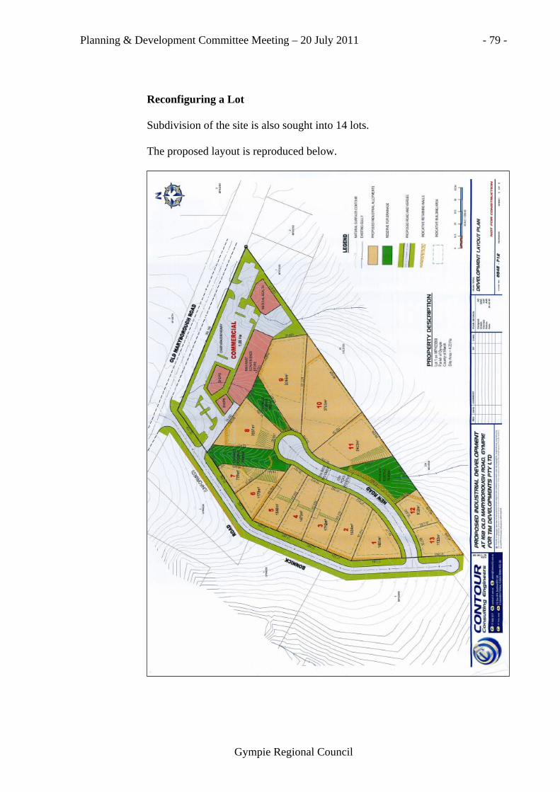
Planning & Development Committee Meeting – 20 July 2011 - 79 -
Gympie Regional Council
Reconfiguring a Lot Subdivision of the site is also sought into 14 lots. The proposed layout is reproduced below.
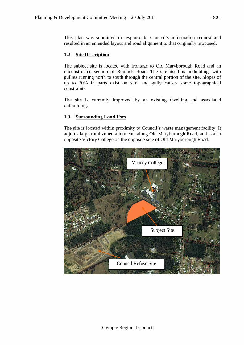
Planning & Development Committee Meeting – 20 July 2011 - 80 -
Gympie Regional Council
This plan was submitted in response to Council’s information request and resulted in an amended layout and road alignment to that originally proposed. 1.2 Site Description The subject site is located with frontage to Old Maryborough Road and an unconstructed section of Bonnick Road. The site itself is undulating, with gullies running north to south through the central portion of the site. Slopes of up to 20% in parts exist on site, and gully causes some topographical constraints.
The site is currently improved by an existing dwelling and associated outbuilding. 1.3 Surrounding Land Uses The site is located within proximity to Council’s waste management facility. It adjoins large rural zoned allotments along Old Maryborough Road, and is also opposite Victory College on the opposite side of Old Maryborough Road.
Victory College
Subject Site
Council Refuse Site

Planning & Development Committee Meeting – 20 July 2011 - 81 -
Gympie Regional Council
2.0 STATUTORY REQUIREMENTS 2.1 Intent of the Zone The intent of the Rural Zone is for sustainable rural uses to predominate; and for valuable economic resources to be sustainably managed. It also provides for industrial uses that create a demonstrated community benefit and economic opportunity, are of a nature and scale precluding a location in other zones, must be located in proximity to economic resources and are sensitively located in accordance with community expectations. It is considered that the proposal meets these requirements as it has been established that there is an Industrial shortage of land within Gympie. This portion of land is zoned Rural, however is on the fringes of town in an expanding area. It is considered a logical extension of the land use given the existing and future proposed uses of land along Bonnick Road. 2.2 State Planning Policies State Planning Policy Healthy Waters is applicable to the development and discussed in the design services assessment following. 2.3 Planning Scheme Provisions The application was lodged under the Cooloola Shire Planning Scheme 2005. The assessment of the proposal is two-fold, by means of Council’s assessment of the Preliminary Approval to have the land assessed under the provisions of Industrial and Commercial development, and the subsequent subdivision of the portion of land to create thirteen (13) industrial and a balance area in the northern portion of the site to be utilised as a Commercial precinct. Material Change of Use The Material Change of Use section of the application is Impact Assessable and is assessable against the entire scheme. The main issue for consideration for this part of the proposal is the need for this kind of development on a Rural portion of land. The applicant originally made application for the site to be subdivided for Housing purposes, however the proposal was later amended to reflect an Industrial and Commercial subdivision as is reflected in this Development Application. The proposal is considered to be a relevant land use for this location, given the existing industrial development on Bonnick Road and Council’s waste landfill site. The small scale commercial development proposed to front Old Maryborough Road is also considered appropriate given the growth in this area and limited facilities currently available.

Planning & Development Committee Meeting – 20 July 2011 - 82 -
Gympie Regional Council
Following amendment to the subdivision component of the proposal, the proposed lot boundaries no longer correlate with the two (2) proposed industrial precincts. In this regard, however, it is considered appropriate to retain the low impact industries on the lots fronting Bonnick Road by requesting an amended material change of use plan that allocates ‘Industrial Area A’ over lots 1-7. Through the proposed amendments to Council’s existing Assessment Tables general industries will be prevented from locating on lots fronting Bonnick Road and Old Maryborough Road, and land immediately to the south of the development site is not freehold (ie State Land). A noise report was requested to support the application and was provided. The Study, prepared by David Moore and Associates, provides analysis of a variety of light and medium industrial uses over the site. All of the assessed noise sources were considered acceptable to comply with recommended daytime noise limits. The report, however, indicates that evening noise limits will be exceeded by up to 6 dB(A) with the number of sources exceeding the maximum noise limit being seven (7). It is therefore recommended that without further noise assessment of individual uses and probably noise control measures, evening operations should not be permitted relative to the closest industrial lots to the closest residence to the north-west. This would apply to proposed lots 1-8 and is consistent with the ‘Industrial Area A’ proposed for these lots. Uses intended for the commercial precinct are all considered to effectively comply with maximum noise limits for the complete 24-hour day. The development of all proposed allotments will require further Development Permits for Material Changes of Use to be obtained and the assessment of noise can be further considered at this stage. The commercial precinct is intended to attract the establishment of a corner store and some other local catchment shops and/or offices. Reconfiguring a Lot The Reconfiguring a Lot section of the application is Code Assessable development under the provisions of the scheme, and is assessable against the following codes: Gympie Planning Area Code The development is consistent with the outcomes sought for the Gympie Planning Area.

Planning & Development Committee Meeting – 20 July 2011 - 83 -
Gympie Regional Council
Reconfiguring a Lot Code This subdivision proposes a logical consolidation of the area along Old Maryborough Road and Bonnick Road. The land is zoned Rural however the development site is positioned within an emerging area of Gympie and is considered appropriate for this area. Provisions for industrial allotments include: - minimum 600m2 lot size; - minimum lot rectangle of 30 metres x 20 metres; - minimum road frontage of 25 metres per allotment. Provisions for commercial allotments include: - minimum 400m2 lot size; - minimum road frontage of 6 metres per allotment.
All proposed lots are able to meet the requirements for subdivision within the Industrial and Commercial Zones, however, some lots will require earthworks to be able to accommodate an appropriate flattened area suitable for future development. SO-2: this relates to the structured road network. The applicant proposes to construct Bonnick Road and an internal road network throughout the site servicing the industrial lots. The extent of this development application has Bonnick Road terminating via cul-de-sac at the extent of the property frontage to the south-west of the site. It is recommended that Bonnick Road be designed to allow for through traffic. The road alignment will allow for natural drainage paths to be followed and proposes drainage reserves throughout the development also. Design Department comments refer further in relation to this matter.
SO-12: refers to the size and proportions of lots, incorporating gradients. The proposed lot sizes generally comply with Council’s minimum requirements. Some earthworks will need to be undertaken to achieve suitable areas for future development over the new allotments and a condition has been prepared in this regard. SO-14: has regard to the compatibility of the proposal with adjoining development. This relates most specifically to the anticipated future land uses along Bonnick Road. It is anticipated that this proposed land use is compatible with Council’s future plans for this area. The proposal complies with relevant aspects of the Reconfiguring a Lot Code and has given due consideration to connectivity with adjacent sites able to be developed in the future.

Planning & Development Committee Meeting – 20 July 2011 - 84 -
Gympie Regional Council
2.3.3 Landscaping Code Council would require the provision of landscaping when Material Change of Use applications are lodged on the individual allotments in the future. The same is required for Commercial developments. 2.3.4 Infrastructure Works Code
Design Department comments refer. 2.3.5 Conservation Significant Areas Code The site is crossed in the south-west corner by ‘Local Connectivity Value’. It appears this corridor was allocated as it was undeveloped land connecting existing stands of locally significant vegetation. With this area now included in the Urban Footprint and the expected demand for expansion of Gympie, it would seem difficult to be able to maintain this corridor.

Planning & Development Committee Meeting – 20 July 2011 - 85 -
Gympie Regional Council
The corridor has already been compromised by the approval of the Heights Drive unit development and residential subdivision on Old Maryborough Road. 2.3.6 Resource Areas Code The site is classified as Good Quality Agricultural Land. In addressing the Code, consideration can be given to the site’s inclusion in the Urban Footprint designation under the DWBBSPRP. Additionally, under the 2005 Planning Scheme the rural zone allocated within proximity to Gympie was not intended to be preserved for agricultural purposes, but was used more to prevent out of sequence urban expansion. 3.0 PLANNING CONSIDERATIONS 3.1 Draft Wide Bay Burnett Regional Plan The subject site is located within the Urban Footprint under Draft Wide Bay Burnett Regional Plan. Old Maryborough Road acts as the boundary between the Urban Footprint and the Rural Living Area. The proposed development is consistent with this Plan.

Planning & Development Committee Meeting – 20 July 2011 - 86 -
Gympie Regional Council
Draft WBBSPRP 2010 3.2 Land Use The proposal is considered appropriate, even though the site is zoned Rural. The practicality of the proposal has been given due consideration throughout the assessment process, and the site is consolidating the Urban Area on the fringes of Gympie with due consideration being given to possible future nearby uses. The Regional Plan reflects the view that the site is within an area appropriate for urban uses including those of which are proposed. 3.3 Site Access and Traffic The developer will be required to construct Bonnick Road for the full extent of the property frontage plus the new internal road to service all of the lots, including the associated infrastructure such as street lighting, kerb and channel etc. Design Department report refers below.
3.4 Park Park contributions are not normally levied on industrial or commercial developments.

Planning & Development Committee Meeting – 20 July 2011 - 87 -
Gympie Regional Council
4.0 CONSULTATION 4.1 Internal (a) Design Department
Report: (Manager, Major Projects – N. Weller) This Engineering report is based on information submitted to support the application as follows: Proposal Report – Martoo Consulting – May 2010 Letter – Tim Developments – 6 December 2010 Traffic Impact Assessment – Hayes Traffic Engineering - November 2010 Letter – Tim Developments – 21 December 2010 Contour Consulting Engineers Drawing No’s 0345-P12 Rev 0, 0345-E01 Rev 0, 0345-E02 Rev 0. TRAFFIC The Hayes report addresses the traffic impact of 18 industrial lots plus commercial precinct. The proposal is for 13 industrial lots plus a commercial precinct. This difference will not impact on the report conclusions. The report assesses the traffic impact of all the industrial and commercial traffic using Old Maryborough Road. At full development it is expected that this proposal would add approximately 359 vehicles to Old Maryborough Road traffic at a peak hour which would roughly coincide with peak traffic from Victory College. When the industrial precinct of this proposal has been developed, it is intended to make Bonnick Road a through road and this will change traffic patterns. The full development conclusions of the Hayes report are generally acceptable. SUBMISSIONS Of the four (4) submitters, one (1) is supporting the development, one (1) does not raise any concern with traffic, and two (2) have concerns with the additional (heavy) traffic.
CONCERN RESPONSE Traffic queues across the Bonnick Road intersection at times
Cannot be addressed in this development because external to this development.
Cars parking opposite the Bonnick Road intersection
No Standing Zone will be installed around the intersection.
Traffic exiting the school and entering the commercial precinct will disrupt traffic flow.
The carriageway will be widened to accommodate movements.

Planning & Development Committee Meeting – 20 July 2011 - 88 -
Gympie Regional Council
The addition of heavy traffic to the B-Double Route, quarry traffic and flood-diverted traffic.
The road is currently a sub-arterial road and proposed as a sub-arterial road. The additional heavy traffic comes with the development of the Region.
Another 486 vehicles per hour through the Bonnick Road intersection
The intersection analysis takes all this into account, to establish the geometry of the intersection. The opening of Bonnick Road through to Corella Road may reduce the amount of traffic using this intersection.
Traffic from the development will inevitably clash with school peak times causing congestion and safety issues.
The road is a sub-arterial road and will have a continual increase in traffic. The traffic report has addressed the proposed intersection and accesses to the commercial precinct. No Standing Zones will be introduced on both sides of the road to attempt to prevent parents exposing their children to excessive risk.
Council ensure that provision is made for the safe access to the Victory College complex at no cost to the Victory College conglomerate.
The conclusion of the traffic report combined with the additional requirements of the proposed conditions are aimed at providing safe solutions to the impact of traffic generated by this development.
As an urban sub-arterial road, Old Maryborough Road should be widened to 12 metres including turn lanes for the frontage of the development plus the extent of the intersection with Bonnick Road. The intersection with Bonnick Road should be constructed to basic left turn and channelized right turn treatments. A school speed zone covers the frontage of the school. No Standing areas should be established for full frontage of the school and the Old Maryborough Road frontage of the development. Council’s pathway system crosses Old Maryborough Road at the extreme south eastern corner of the school, just beyond the frontage of this development. This is the obvious place to locate any proposed pedestrian facilities. Discussion with the school confirms this. The type of facility will be determined by warrants, established after Council receives a request for a School Crossing from the School. Pedestrian (disabled) access should be provided from this crossing to the pedestrian ways of the commercial development.

Planning & Development Committee Meeting – 20 July 2011 - 89 -
Gympie Regional Council
The Old Maryborough Road access to the commercial facility will be approximately 60 metres from the proposed facility. This access should be constructed to basic left and right turn standards with provision for passing. FRONTAGE ROADS Old Maryborough Road is classified as a sub-arterial road. The existing carriageway is approximately 8 metres wide with kerb and channel on the school side. The development frontage and the extent of the intersection works should be widened to urban sub-arterial standard. The far north western access to the school should be provided with BAR treatment. No standing zones should be established for the intersection, frontage of the development and frontage of the school. These zones could be time and day limited. Bonnick Road is currently unconstructed but when constructed will be urban sub-arterial. As such it requires a 22 metre road reserve and 12 metre carriageway. Considering that there will be only two (2) intersections / accesses and that there should be no demand for on-street parking in front of this development as proposed; it is recommended that the frontage of the development be constructed to a 9 metre carriageway with no standing on the development side. This arrangement should fit into the existing 20 metre road reserve with some minor road reserve widening at lots 6 & 7. CAR PARKING 185 car parks are nominated for the commercial precinct. This complies with the Planning Scheme requirements. Disabled bays have not been nominated and provision of these to current standards will necessitate adjustments to the conceptual layout. EARTHWORKS Substantial earthworks including 5 metre high retaining walls are proposed. STORMWATER DRAINAGE In the main, existing gullies are to be retained in drainage reserves. It is suggested that the proposed reserves be converted to easements and incorporated in a lot. Retention will be required for the commercial precinct and the industrial precinct (SPP Healthy Waters). There appears to be sufficient treatment of stormwater between the site and Gympie Creek to not require treatment at the site. FLOODING The site is not subject to major stream flooding. WATER SUPPLY The proposed development can be serviced from Old Maryborough Road.

Planning & Development Committee Meeting – 20 July 2011 - 90 -
Gympie Regional Council
SEWERAGE Sewer mains will have to be extended from Bonnick Road Waste Management Facility to connect the development to sewer. TELECOM AND POWER These services should be able to be provided from Old Maryborough Road or by extension of Bonnick Road services. INFRASTRUCTURE CHARGES AND INFRASTRUCTURE CONDITIONS The subject site is outside the PIA. Council can therefore impose, by condition, charges for existing / proposed infrastructure and provision of infrastructure used / required for this development. It is recommended that Council apply infrastructure charges calculated in accordance with its existing policies. It is recommended that the cost of connection to the water and sewerage networks be met by the development. Council could give consideration to reducing the Roadworks Infrastructure charge to 50% of that calculated by PSP13 in consideration for providing the frontage roadworks. 4.2 External (a) Department of Local Government and Planning This application was referred to the Queensland Department of Local Government and Planning (known at the time as Department of Infrastructure and Planning) as a Concurrence Agency. They advise that they have no requirements in regards to the proposal. 5.0 PUBLIC NOTIFICATION The proposal was required to be publicly notified due to the nature of the Preliminary Approval for Industrial and Commercial Development. There were five (5) submissions (nb 2 received from 1 submitter) received objecting to the proposal. Included in these was one (1) submission in support for the proposal. The issues are outlined below and a consequent planning comment in regards to each of the issues raised in the submission. SUBMISSION 1
Issue Comment 1. Traffic issues arising from the presence of Victory College and the proposed new commercial precinct directly opposite. There is also a proposed new intersection where parent vehicle queue at peak periods at the start and end of the school day.
1. Design comments relate. A satisfactory traffic study has been submitted and assessed by Council. The detailed design of roadworks and intersections will be dealt with at Operational Works Stage.

Planning & Development Committee Meeting – 20 July 2011 - 91 -
Gympie Regional Council
2. Noise issues arising from the proposed new industrial development to the south of the subject site.
2. There is an acknowledged shortage of industrial land in Gympie, and the rural land allows for industrial developments if the need exists. The development is considered to offer suitable transition between general industries and the surrounding residential development by the precincts proposed (ie low impact industries and commercial development positioned as buffers) and land immediately adjoining to the south is not freehold. The development of each lot will still require a Material Change of Use approval so specific noise impacts can be assessed in more detail at that stage.
SUBMISSION 2
Issue Comment 1. Devaluation of property arising from the proposed development adjacent.
1. Devaluation of property is not a town planning issue.
SUBMISSION 3
Issue Comment 1. Traffic issues arising from the presence of Victory College and the proposed new commercial precinct directly opposite. There is also a proposed new intersection where parent vehicle queue at peak periods at the start and end of the school day.
1. Design comments relate. A satisfactory traffic study has been submitted and assessed by Council. The detailed design of roadworks and intersections will be dealt with at Operational Works Stage.
2. Safety issues regarding the nature of vehicles to service the proposed development, specifically within the industrial area.
2. A satisfactory traffic report has been submitted with the application incorporating recommended safety measures, and Design comments further relate.

Planning & Development Committee Meeting – 20 July 2011 - 92 -
Gympie Regional Council
SUBMISSION 4
Issue Comment 1. The proposed new intersection will be directly opposite the entrance point for Victory College, causing conflict.
1. Bonnick Road is already gazetted as road reserve. Council can not change its location, this proposal aims only to construct road that already exists.
2. Any cost of alteration to Victory College access/egress points is to not be borne by the school.
2. This is a separate issue to this proposal.
6.0 CONCLUSION The application proposes logical consolidation of the existing Old Maryborough Road locality and the uses proposed are considered well positioned and needed. It is recommended that the application be approved subject to conditions to be determined by the Director of Planning and Development.
P36/07/11 Moved: Cr L.J. Friske Seconded: Cr R.A. Gâté Recommend that Council, as Assessment Manager, APPROVE development application 2010-0860 for Material Change of Use Seeking a Preliminary Approval to Vary the Effect of the Local Planning Scheme for Industrial and Commercial Development and Reconfiguring a Lot – Subdivision to Create Fourteen (14) Additional Lots over Lot 1 on MPH23959, located at 168 Old Maryborough Road, Gympie, subject to conditions to be determined by the Director of Planning and Development but including: (i) The submission of an amended plan for the material change of use
component that allocates ‘Industrial Area A’ over lots 1-7; and (ii) Levying 50% of the road contribution nominated by Planning
Scheme Policy 13: Urban Road Contributions for all subsequent developments on the approved lots.
Carried.

Planning & Development Committee Meeting – 20 July 2011 - 93 -
Gympie Regional Council
COUNCIL IN COMMITTEE
The Chairman advised the meeting that Council was going “Into Committee” to discuss
1. Compliance Team Agenda Appendix 2. Alleged Unlawful Businesses at Cooloola Cove and Tin Can Bay P37/07/11 Moved: Cr J.A. Walker Seconded: Cr D.R. Neilson That pursuant to the provisions of Section 72 of the Local Government
(Operations) Regulation 2010, Council resolves to close the meeting to the public and move “into committee” to consider the following matter/s:-
1. Compliance Team Agenda Appendix 2. Alleged Unlawful Businesses at Cooloola Cove and Tin Can Bay Further, that in relation to the provisions of Section 171 of the Local
Government Act 2009, Council resolves that following the closing of the meeting to the public and the moving ‘into committee’ that all matters and all documents (whether in hard copy, electronic, optical, visual or magnetic form) discussed, raised, tabled and/or considered whilst the meeting is closed and ‘in committee’, are confidential to the Council and the Council wishes to keep them confidential.
Carried.
COUNCIL OUT OF COMMITTEE P38/07/11 Moved: Cr R.A. Gâté Seconded: Cr J.A. Walker That proceedings be resumed in Open Council.
Carried.

Planning & Development Committee Meeting – 20 July 2011 - 94 -
Gympie Regional Council
SECTION 7: “IN COMMITTEE” ITEMS
7/1 Compliance Team Agenda Appendix
P39/07/11 Moved: Cr A.J. Perrett Seconded: Cr J.A. Walker
Recommend that the information be noted.
Carried.
7/2 Alleged Unlawful Businesses at Cooloola Cove and Tin Can Bay
P40/07/11 Moved: Cr R.J. Dyne Seconded: Cr G.L. Engeman
Recommend that Council prioritises the complaints.
Carried.
SECTION 8: GENERAL BUSINESS
Nil
ADJOURNMENT OF MEETING The meeting adjourned for morning tea at 10.13 a.m. RESUMPTION OF MEETING The meeting resumed at 10.35 a.m. Appointment attendees Paul McDonald & Warren Raddatz from DERM
entered the meeting at 10.35 a.m. and provided a powerpoint presentation. Cr R.J. Dyne was not present when the meeting recommenced. Cr R.A. Gâté left the meeting at 10.37 a.m. and returned to the meeting at
10.42 a.m. Cr R. J. Dyne returned to the meeting at 10.50 a.m.

Planning & Development Committee Meeting – 20 July 2011 - 95 -
Gympie Regional Council
Cr R.J. Dyne and Cr I.T. Petersen left the meeting to attend a media appointment at 10.55 a.m.
Cr I.T. Petersen vacated the Chair and Cr J. Watt (Proxy Chairman) assumed the role of Chairman of the meeting. Cr R.J. Dyne returned to the meeting at 11.02 a.m. Cr I.T. Petersen returned to the meeting at 11.06 a.m. Cr J. Watt vacated the Chair and Cr I.T. Petersen resumed the role of Chairman of the meeting. Cr G.J. Engeman left the meeting at 11.13 a.m. and returned to the meeting at 11.17 a.m. Appointment attendees Paul McDonald & Warren Raddatz left the meeting at 11.25 a.m.
SECTION 9: ATTACHMENTS Attachment 1: Correspondence from Martoo Consulting (3/1) Attachment 2: Building Statistics (See Item 5/1)
There being no further business the meeting closed at 11.25 a.m.
CONFIRMED THIS THE THIRD DAY OF AUGUST 2011.
_____________________________________________ Cr I.T. Petersen
Chairman