20101117 legible london_pt_101117_for_kidp_aig김경모
49
Applied Information Group 어플라이드 인포메이션 그룹
Transcript of 20101117 legible london_pt_101117_for_kidp_aig김경모

Applied Information Group어플라이드 인포메이션 그룹
© 2010 applied information group legible london
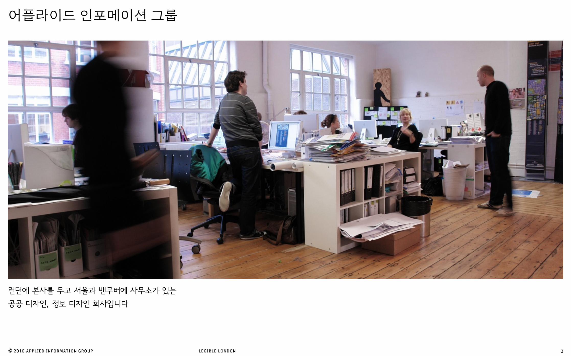
런던에 본사를 두고 서울과 밴쿠버에 사무소가 있는
공공 디자인, 정보 디자인 회사입니다
어플라이드 인포메이션 그룹
2

© 2010 applied information group legible london
영국 Local Town Planning 상 수상영국 DBA Design Effectiveness Award for Environments 상 수상
“heads-up” 지도 표시 체계
브리스톨 레지블 시티, 영국
3
© 2010 applied information group legible london
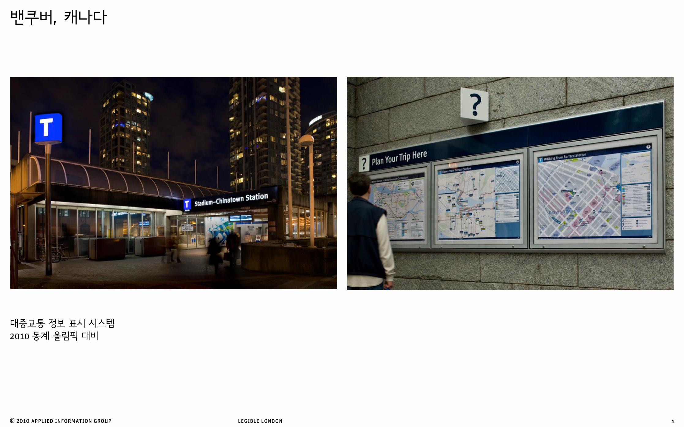
대중교통 정보 표시 시스템2010 동계 올림픽 대비
밴쿠버, 캐나다
4
© 2010 applied information group legible london
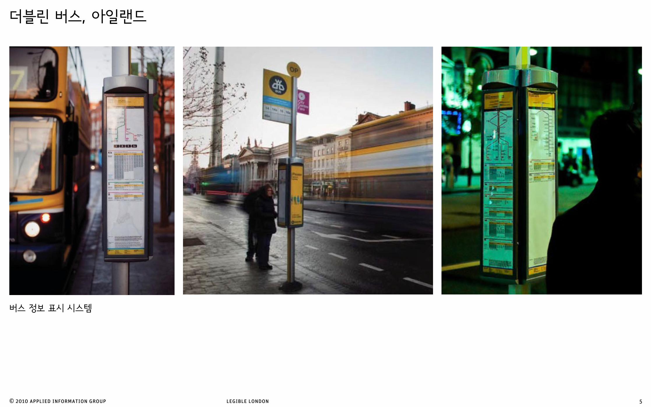
버스 정보 표시 시스템
더블린 버스, 아일랜드
5

© 2010 applied information group legible london
보행자용 정보 표시 시스템
글래스고, 영국
6

© 2010 applied information group legible london
보행자용 정보 표시 시스템
브라이튼, 영국
7
BR
ILLS
LA
NE
POOLPSG
B A R T H O L OM E W S
E A S T S T R E E T A R C A D E
D U KE S L A N E
C L A R E N C E Y D
S H I P ST CT
U N I O N S T R E E T MEE
T IN
G H
OU
SE LN
B L A C K L I O N L A N E
S H I P S T R E E T G A R D E N S
AIR S T R E E T
I M P E R I A L A R C A D E
REGENCY ROAD
S T E I N E L A N E
PALACE P
L
PAV
I LI O
NB
UI L
DIN
GS
PRIN
CES
P LA
CE
B O N D S T L A N E
B O N D S T R O W
MA
RLB
. PL
J U N C T I O NR O A D
BR
IGH
TON
PL
S
P O W I S G R O V E
CA
NN
ON
PL A
CE
RE
GE
NT
HI L
L
C L I F T O N T E R R A C E
U P P E R N O R T H S T R E E T
GR
EN
VI L
L E S
T
D U K E ’ S P A S S A G E
JE
W S
TR
EE
T
KI N
G S
TR
EE
T
ZIO
N G
AR
DE
NS
F RE
DE
RI C
K S
TR
EE
T
F RE
DE
RI C
K G
AR
DE
NS
OR
AN
GE
RO
WTI C
HB
OR
NE
ST
SP
RI N
G G
AR
DE
NS
C H U R C H S T R E E T
S T NI C
H O L A S RO A D
CE
NT
UR
I ON
RO
AD
NE
W D
OR
SE
T S
TR
EE
T
NO
RT
H G
AR
DE
NS
KE
W S
TR
EE
T
F OU
ND
RY
ST
RE
ET
QU
EE
N‘ S
GA
RD
EN
S
UP
PE
R G
AR
DN
ER
ST
RE
ET
KE
NS
I NG
TO
N S
TR
EE
T
RO
BE
RT
ST
RE
ET
PE
LHA
M S
TR
EE
T
ST
GE
OR
GE
‘ S M
EW
S
ST
GE
OR
GE
‘S P
LAC
E
TI D
Y S
TR
EE
T
G L O U C E S T E R S T R E E T
G L O U C E S T E R R O A D
KE
NS
I NG
TO
N P
L AC
E
TR
AFA
L GA
R L
AN
E
KE
MP
ST
RE
ET
OV
ER
ST
RE
ET
F RE
DE
RI C
K P
L AC
E
WH
I TE
CR
OS
S S
TR
EE
T
BL A
CK
MA
N S
TR
EE
T
STA
TI O
N S
TR
EE
T
W E S T H I L L R O A D
ALE
XA
ND
RA
VI L L A
S
A L B E R T R O A D
U P P E R G L O U C E S T E R R O A D
SU
RR
EY
ST
RE
ET
BU
CK
I NG
HA
M S
TR
EE
T
GU
I LD
F OR
D S
TR
EE
T
A L F R E D R O A D
L E O P O L D R O A D
B U C K I N G H A M R
O A D
G U I L D F O R D R O A D
T E R M I N U S S T R E E T
CIR
CU
S S
TR
EE
T
B L E N H E I M P L A C E
CH
ELT
EN
HA
M P
L AC
E
VI N
E S
TR
EE
T
NO
RT
H P
L AC
E
JU
BI L
EE
ST
RE
ET
RE
GE
NT
ST
RE
ET
S O U T H S T R E E T
MID
DL E
ST R
E ET
BLA
CK
LI O
N S
TR
EE
T
PO
RT
L AN
D S
TR
EE
T
PA
VI L
I ON
PA
RA
DE
C A S T L E S Q U A R E
P O O L V A L L E Y
LIT
TL E
EA
ST
ST
P R I NC E A L B
E RT S
T R E E T
K I N G ’ S R O A D
SH
I P S
T RE E
T
MID
DL E
ST
RE
ET
R U S S E L L R O A D
R U S S E L L R O A D
RU
SS
EL L
PL A
CE
QU
EE
N S
QU
AR
E
W E S T E R N R O A D
B O Y C E S S T R E E T
WIN
DS
OR
ST
RE
ET
KI N
G P
L AC
E
E D W A R D S T R E E T
ST
EIN
E S
TR
EE
T
CH
AR
L ES
ST
RE
ET
MA
NC
HE
ST
ER
ST
RE
ET
PR
I NC
E S S
T RE E
T
ST
EI N
E G
AR
DE
NS
GR
AN
D
PAR A D E M E W S
MA
RK
ET
ST R E E TN I L E S T R E E T
OLD
ST
EI N
E
OL D
ST E I N
E
OLD
ST
EI N
E
OL D
ST E I N
E
O L D S T E I N E
G L O U C E S T E R R O A D
SH
I P S
TR
EE
T
CA
NN
ON
PL A
CE
D U K E ’ SC O U R T
KE
NS
I NG
TO
N G
DN
S
SY
DN
EY
ST
RE
ET
GA
RD
NE
R S
TR
EE
T
D U K E S T R E E T
BO
ND
ST
RE
ET
YO
RK
PL
AC
E
S T J A M E S ‘ S S T
N O R T H R O A D
MA
RL B
OR
OU
GH
PL A
C E
GR
AN
D P
AR
AD
E
DY
KE
RO
AD
WE
ST
ST
RE
ET
G R A N D J U N C T I O N R O A D
N O R T H S T R E E T
EA
ST
ST
RE
ET
NO R T H S T R E E T
QU
EE
NS
RO
AD
C H U R C H S T R E E T
M A R I N E P A R A D E
EA
ST
ST
RE
ET
K I N G ’ S R O A D
K I N G ’ S R O A D
GLO
UC
ES
TE
R P
L AC
E
NE
W R
OA
D
T R A F A L G A R S T R E E T
QU
EE
NS
RO
AD
Pavilion Gardens
BrightonSquare
ClarenceSquare
RussellSquare
St. NicholasRest Garden
VictoriaGardens
SteineGardens
Artists’Quarter
PelhamSquare
Steps
Steps
Steps
StepsSteps
Steps
Steps
Steps
Steps
Steps
Underpass
Steps
BrightonMagistrates’Court
IndiaGate
VictoriaFountain
WarMemorial
NorthGate
VictoriaStatue
MazdaFountain
PavilionTheatre
CornExchange
TheLanes
ChurchStreet
NorthRoad
Churchill SquareCar Park 1Shopmobility
Churchill SquareCar Park 2
RussellRoad
CoachStation
TrafalgarStreet
BlackmanStreet
BrightonStation
Universityof BrightonGrand ParadeBuilding
BrightonPier
FriendsMeetingHouse
TheatreRoyal
JubileeLibrary
BrightonBuddhist
Centre
St. NicholasChurch
St. Peter’sChurch
City CollegeBrighton& Hove
ClockTower
Churchill SquareShopping Centre
Sea LifeCentre
The Grand BrightonCentre
The SeafrontO!ce
BeachVolleyball
St Paul’sChurch
Middle StreetSynagogue
FishingMuseum
BrightonTown Hall
TrinityChurch
Prince RegentSwimmingComplex
OldCourtroom
BrightonMuseum &Art Gallery
BrightonDome
Brighton Toy &Model Museum
VisitorInformation
RoyalPavilion
NORTHLAINE
THE LANES
CULTUR ALQUARTER
SEAFRONT
MONTPELIER & CLIFTON HILLR
egen
cy "
min
"#m
in H
ove
Brighton M
arina #$min
#min K
emptow
n
#min London Road
N
About $min walk
Central Brighton
Copyright © 2009 Brighton & Hove City Council, using map design and source data supplied under licence. All rights reserved. Designed by Applied Information Group.
This free map is part of a new public scheme for Brighton that includes information points ( on map) in the street, downloadable maps from visitbrighton.com and an iPhone app – all designed to help you find your way around
This map is printed on Cyclus Print paper100% recycled from post-consumer waste andaccredited by the Forestry Stewardship Council
walking map
© 2010 applied information group legible london
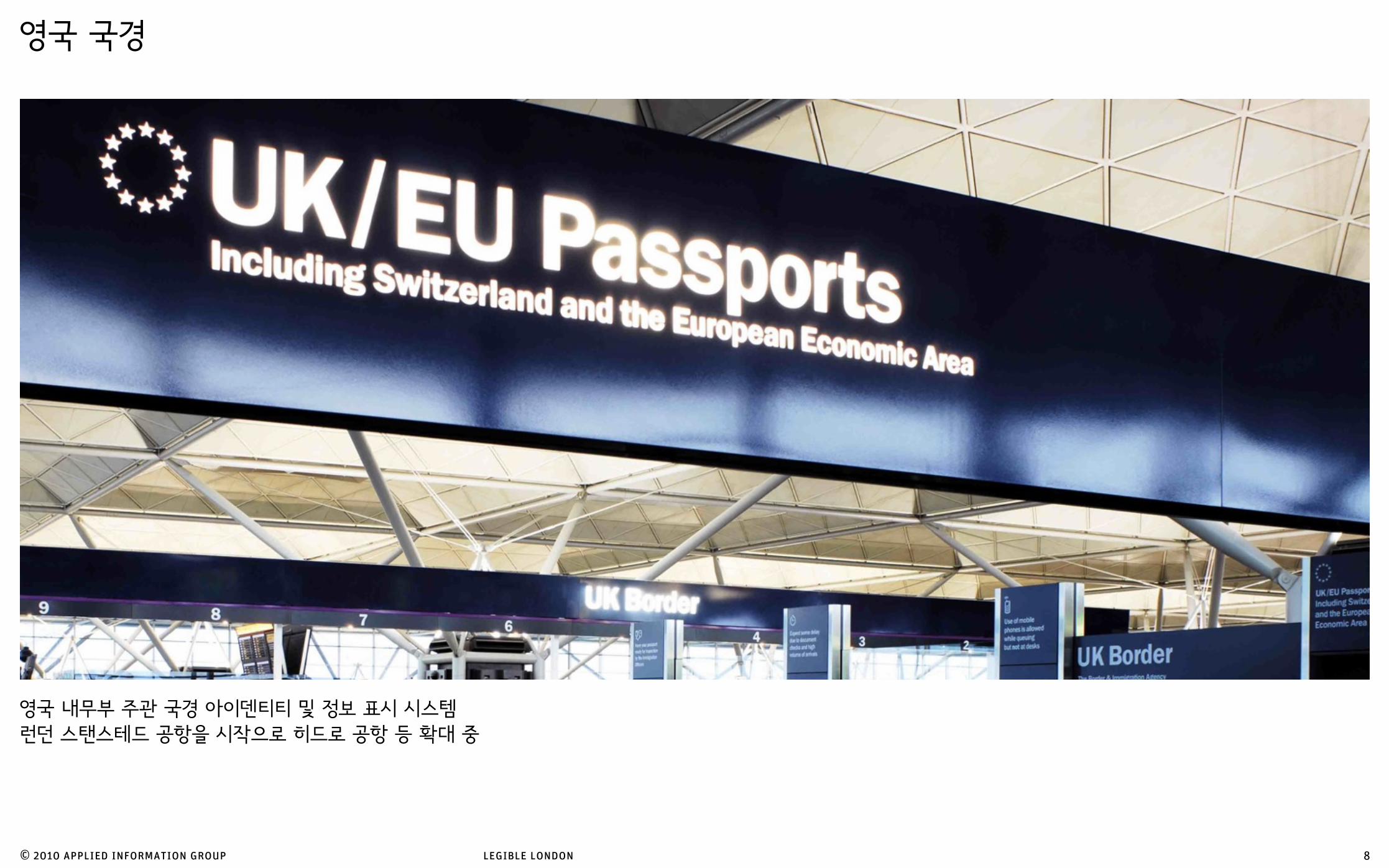
영국 내무부 주관 국경 아이덴티티 및 정보 표시 시스템런던 스탠스테드 공항을 시작으로 히드로 공항 등 확대 중
영국 국경
8

© 2010 applied information group legible london
런던의 보행자용 정보 표시 체계
미국 Society for Environmental Graphic Design (SEGD) 상 수상
영국 DBA Design Effectiveness Gold 수상
영국 Ordinance Survey MasterMap Award for Better Mapping 수상
레지블 런던, 영국
9

Legible London읽기쉬운 런던

© 2010 applied information group legible london
읽기쉬운 도시의 개념 (간단하게)
11
시민과 관광객에게 도시에 대한 각종 정보를 언제 어떻게 효과적으로 제공할것인가

© 2010 applied information group legible london
읽기쉬운 런던의 목표
2015년 까지 걷기 쉬운 런던을 만들자는 켄 리빙스턴 시장의 선언 (2004)
12

© 2010 applied information group legible london
읽기쉬운 런던의 목표
걷기의 좋은점 1
공공 건강 증진
13

© 2010 applied information group legible london
읽기쉬운 런던의 목표
14
걷기의 좋은점 2
골목 및 지역 상권의 활성화

© 2010 applied information group legible london
읽기쉬운 런던의 목표
15
걷기의 좋은점 3
런던의 대중교통 부담 감소

© 2010 applied information group legible london
읽기쉬운 런던의 목표
16
걷기의 좋은점 4
길거리 치안 상태 및 안전성 향상

© 2010 applied information group legible london
32개의 각기 다른 정보 표시 시스템이 존재
Londons problems읽기쉬운 런던의 과제
17

© 2010 applied information group legible london
각기 다른 정보 표기법
읽기쉬운 런던의 과제
18

© 2010 applied information group legible london
읽기쉬운 런던의 목표
19
런던의 보행자용 정보 표시체계를 개선하여 기대할 수 있었던 변화:
걷기의 활성화 및
길을 잃지 않을 것이라는 여행객 및 시민들의 심리적 안정감2012 올림픽 관광객 대비

© 2010 applied information group legible london
지하철 교통 체계 지하철 정보 노선 / 시설
버스 교통 체계 버스 정보 도로 (길)
보행 교통 체계 - 정보 도로 (길)
읽기쉬운 도시보행을 교통의 개념으로 접근하기
20
어떻게 하면 보행 정보도 버스나 지하철만큼 체계적으로 제공할 수 있을까

© 2010 applied information group legible london
선구적인 지하철 노선도
하지만 40%이상이 보행을 위해서도 사용하고
노선도만 보아서는 지하철을 타고 가야만할 것 같음
읽기쉬운 런던의 과제
4
4
4
3
3
3
456
5
5
6
3
7
1
1
2
2
4
2
2
889
Transport for London
:
:
:
: Waterloo & City line Mondays - Fridays 0615 - 2148 Saturdays 0800 - 1830 Closed Sundays
: No Hammersmith & City line service Whitechapel - Barking early morning or late evening Mondays to Saturdays or all day Sundays
:
:
:
:
:
No entry from the street on Sundays 1300-1730 (exit and interchange only)
: Replacement bus services ELP:
Canada Water - Rotherhithe and ELC: Canada Water - New Cross Gate
: Step free interchange at street level between Tube and DLR
:
Open Mondays to Fridays until 2100 only. Saturdays 0730-1930. Closed Sundays
:
:
Open Mondays-Fridays only from 14 January 2008 until early 2009
:
: Change at Chalfont & Latimer on most trains
The service between Woodford - Hainault operates until approximately 2400
:
:
This station gets very busy at weekends and evenings. Avoid the crowds by taking a short walk there from Holborn (9 minutes), Leicester Square (6 minutes) or Charing Cross (11 minutes)
:
:
:
:
Earl’s Court - Kensington (Olympia) Mondays to Saturdays 0700-2345, 0800-2345 Sundays
:
:
:
:
:
:
:
: The service between Woodford - Hainault operates until approximately 2400
:
:
: The service between Woodford - Hainault operates until approximately 2400
:
:
:
: Open Mondays to Saturdays until 2345 only. Sundays open until 2315
:
Step free interchange at street level between Tube and DLR
:
:
:
Station is step-free for wheelchair users only
:
At off-peak times on Mondays to Fridays and all day at weekends, all trains to/from Morden run via the Bank branch. To travel to/from the Charing Cross branch please change at Kennington
: Earl’s Court - Kensington (Olympia) Mondays to Saturdays 0700-2345, 0800-2345 Sundays
:
:
:
:
:
:
:
:
:
:
At off-peak times on Mondays to Fridays and all day at weekends, please change at Finchley Central for trains to/from central London
:
:
:
:
Replacement bus service: ELC Canada Water - New Cross Gate
Replacement bus service: ELC Canada Water - New Cross Gate
:
:
:
:
:
:
:
:
:
: Earl’s Court - Kensington (Olympia) Mondays to Saturdays 0700-2345, 0800-2345 Sundays
:
:
:
:
:
:
:
:
:
: No Piccadilly line service Uxbridge - Rayners Lane in the early mornings
:
:
:
The service between Woodford - Hainault operates until approximately 2400
Replacement bus service ELP:
Rotherhithe - Canada Water
:
:
:
:
:
Replacement bus service ELW: Whitechapel - Wapping
Station closed. Replacement bus service ELS: Shoreditch - Whitechapel will operate at the following times: Monday-Friday 0700-1030 and 1530-2030. Saturday - no replacement bus service. Sunday 0700-1500
:
:
:
:
:
:
:
Replacement bus service ELC: Canada Water - New Cross Gate
:
:
:
Closed from June 2008 to
spring 2009 for upgrade works
Also served by Piccadilly line trains early mornings and late evenings
:
:
No Piccadilly line service Uxbridge - Rayners Lane in the early mornings
:
Replacement bus service: ELW Whitechapel - Wapping
: Waterloo & City line
Mondays - Fridays 0615 - 2148 Saturdays 0800 - 1830 Closed Sundays
:
:
:
:
:
:
:
:
: No Hammersmith & City line service Whitechapel - Barking early morning or late evening Mondays to Saturdays or all day Sundays. Replacement bus services ELS: Shoreditch - Whitechapel and ELW: Whitechapel - Wapping
:
:
:
:
: The service between Woodford - Hainault operates until approximately 2400
:
1
3456
2
7 78 8
9 9100m
100m
200m
150m
100m
200m
200m
(no weekend service) 150m
Poster 03.08
100m
340m
( no weekendservice)
( no weekendservice)
( no Sunday service)
International rail servicesnow depart from
King’s Cross St. Pancras
150m
100m
22
22MAYOR OF LONDON
2
21

© 2010 applied information group legible london
걷기가 가능한 거리에 있는 지하철 역들
지리 정보를 반영하지 못하는 노선도의 한계
런던 도심의 지하철 역간의 이동 중 109 종류의 이동은 지하철보다 걷는것이 더 빠름109 journeys between Tube Stations in Central London are quicker to walk above-ground than to travel by Tube.
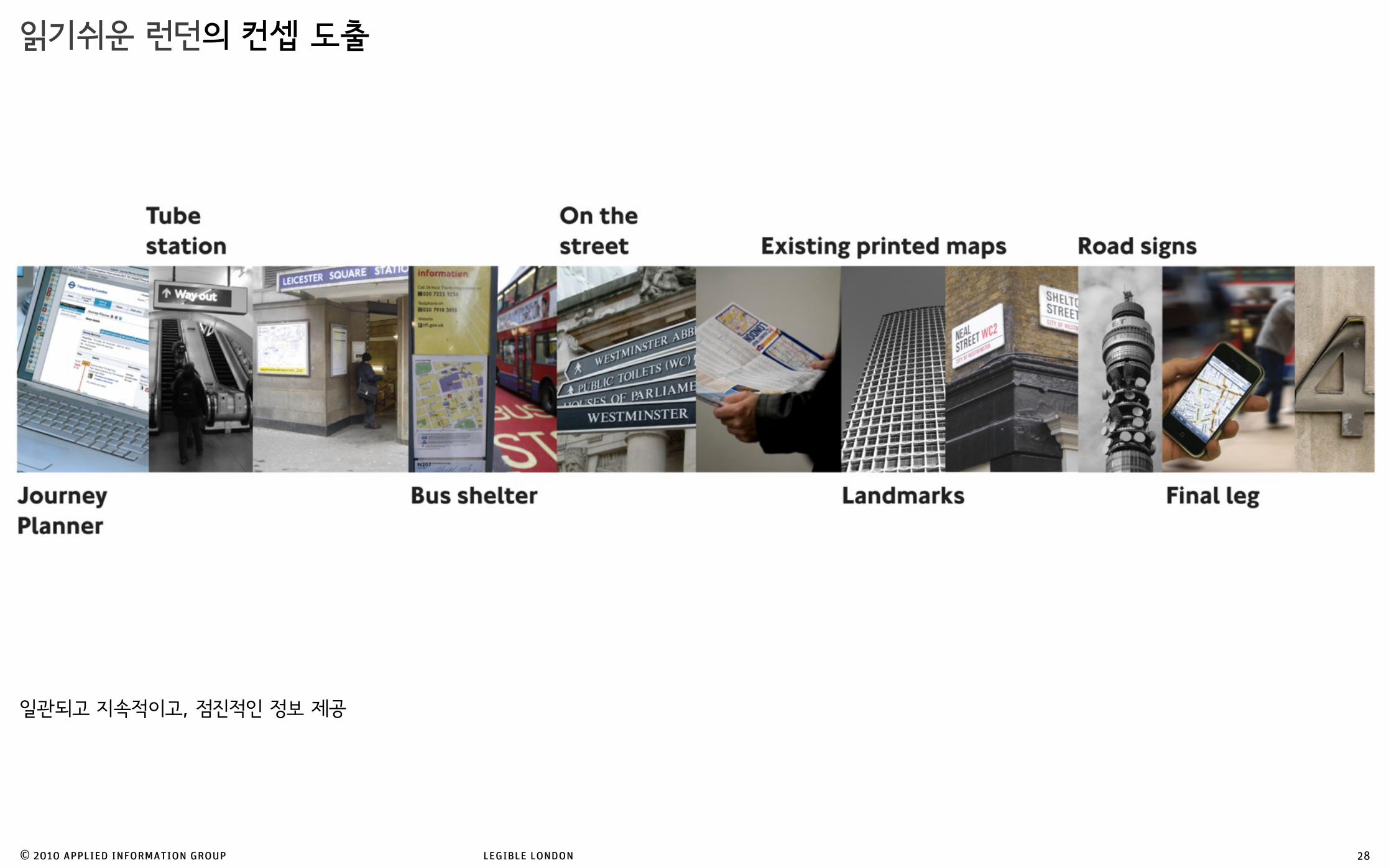
읽기쉬운 런던의 컨셉 도출
22

© 2010 applied information group legible london
코벤트가든 역의 심각한 혼잡성코벤트가든의 인접한 10곳 중 9곳의 지하철 역은 걸어가는 것이 더 빠릅니다.
읽기쉬운 런던의 컨셉 도출
Walkable stations
Covent GardenBank
23

© 2010 applied information group legible london
런던 도심 각 지하철 역의 걸어서 5분 거리에 있는 역들
읽기쉬운 런던의 컨셉 도출
Five-minute walks
24

© 2010 applied information group legible london
지하철 역 주변의 지리 정보만 습득 실제 지리에 맞게 놓은것 읽기쉬운 런던의 목표는
독립적으로 알고 있던 기존의 지리 정보를
서로 연결해주는 것
읽기쉬운 런던의 컨셉 도출
25
© 2010 applied information group legible london
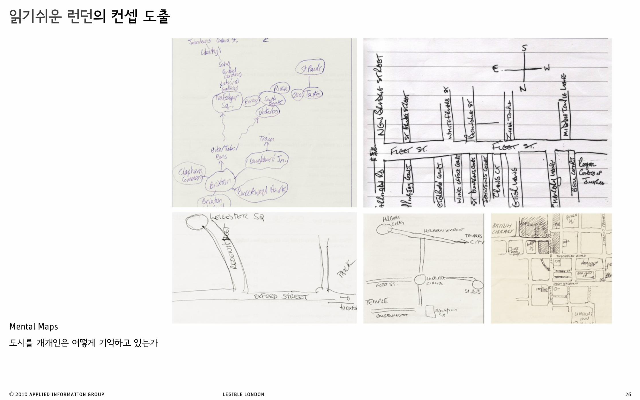
읽기쉬운 런던의 컨셉 도출
26
Mental Maps
도시를 개개인은 어떻게 기억하고 있는가
© 2010 applied information group legible london
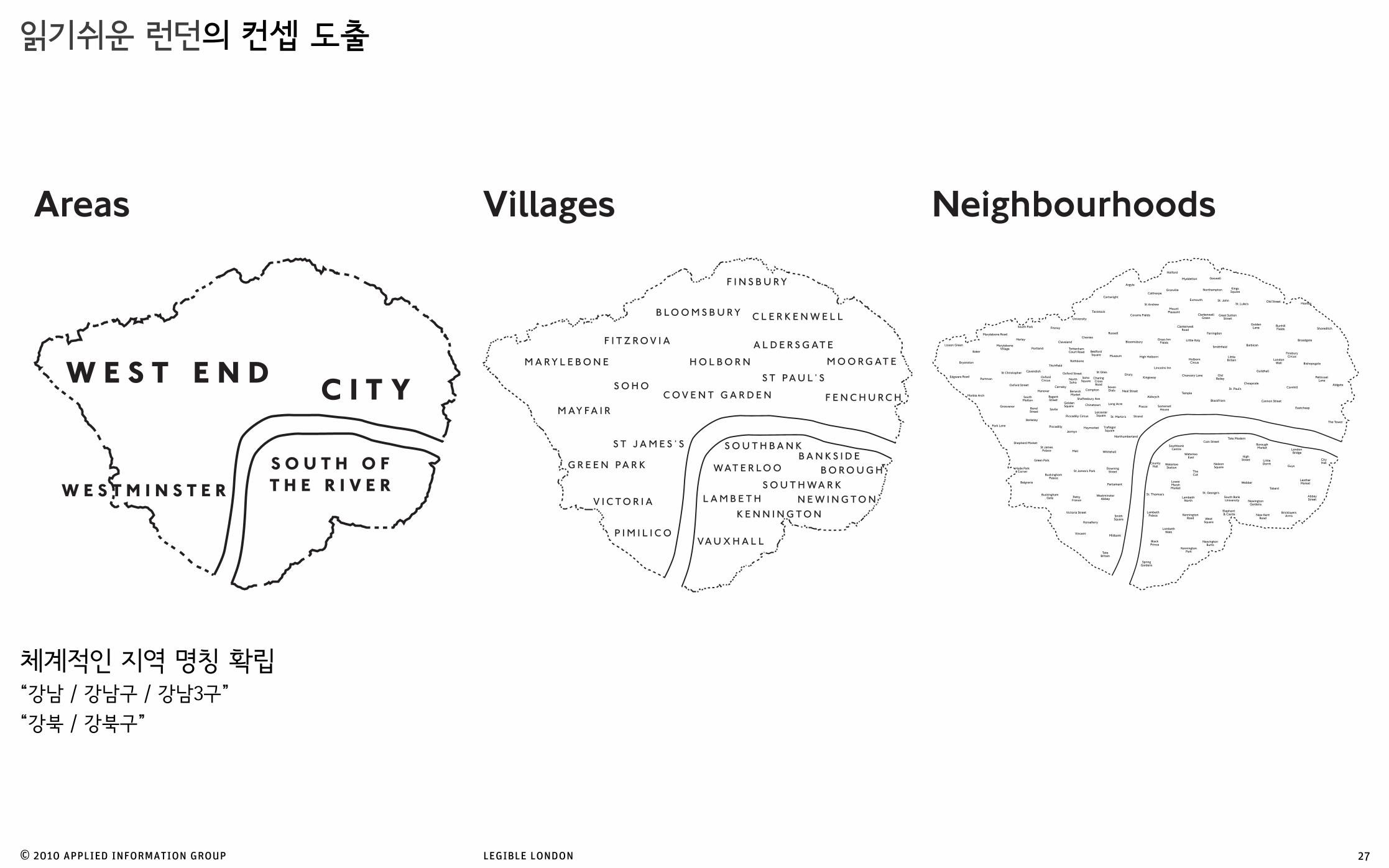
체계적인 지역 명칭 확립“강남 / 강남구 / 강남3구”
“강북 / 강북구”
읽기쉬운 런던의 컨셉 도출
27
Areas Villages Neighbourhoods
© 2010 applied information group legible london
읽기쉬운 런던의 컨셉 도출
28
일관되고 지속적이고, 점진적인 정보 제공

CavendishSquare
BrookStreet
OxfordStreet
WigmoreStreet
Selfridges
HenriettaPlace
SouthMoltonStreet
BondStreet
New BondStreet
LancashireCourt
AveryRow
DaviesStreet
HanoverSquare
John Lewis
Bond Street 프로토타잎 위치 선정의 이유

© 2010 applied information group legible london
다양한 디자인 개발 방식
시민들의 의견 청취 및 반영
장애인 협회와 직접적인 의견교환
읽기쉬운 런던의 디자인 개발Getting feedback
Testing
Mixing media
Options
ExploringListening
30

© 2010 applied information group legible london
표지판의 위치 선정에 있어서 가상 현실에서의 선적용
읽기쉬운 런던의 디자인 개발Rapid prototyping
31

© 2010 applied information group legible london
디자인 발전 과정
읽기쉬운 런던의 디자인 개발
3
8
36
138
293
SOHOMAYFAIR
ST JAMES ’
O X F O R D S T R E E T
TE
ER
TS
T
NE
GE
R
P I C C A D I L L Y
Old
Bo
nd
St r e
et
Ne
w B
on
d S
t r ee
t
G r e a t M a r l b o r o u g h S t r e e t
C o n d u i t S t r e e t
Sa
vi l e
Ro
w
Co
r k S
t r ee
t
St J
am
es
St r e
et
S h a f t e s b u r y Av e n u e
Ha
ym
ar k
et
So
u
LeicesterSquare
The GreenPark
BerkeleySquare
GoldenSquare
SohoSquare
Chinatown
SouthWardour
Carnaby
NorthWardour
Savile Row
SouthMolton
Piccadilly
Rathbone
Haymarket
You are here
PiccadillyCircus
GreenPark
5 minute walk
RoyalAcademy
Liberty
Eros
R I V E R T H A M E S
HYDE PARK
MAYFAIR
PADDINGTON
ST JAMES
VICTORIA
SOHO
COVENT GARDEN
HOLBORN
BLOOMSBURYF ITZROVIA
MARYLEBONE
Euston
Piccadilly Circus
COVENT GARDEN
BLOOMSBURY
Baker
Regent’s Park
Euston Square
Great Portland Street
Goodge Street
Tottenham Court Road
Oxford Circus
Bond Street
Marble Arch
Charing Cross
Embankment
Leicester Square
Covent Garden
Holborn
Hyde Park Corner
Green Park
Warren Street
15 minute walk
You are here
R I V E R T HA
ME
S
B I R D C A G E W A L K
T H E M A L L
S T R A N D
WA
TE
RLO
O B
RID
GE
SO
UT
HA
MP
TO
N R
OW
EV
ER
SH
O BA
KE
R S
TR
EE
TG
LOU
CE
ST
ER
RO
AD
B U C K I N G H A M PA L A C E R
O A D
K I N G ’ S R O A D
P I C C A D I L L Y
PA
RK
LAN
E
BO
ND
ST
RE
ET
PO
RT
LAN
D P
LAC
E
O X F O R D S T R E E T
B A Y S W A T E R R O A D
ED
GW
AR
E R
OA
D
V I C T O R I A E M B A N K M E N T
S H A F T E S B U R Y A V E N U EH I G H H O L B O R N
N E W O X F O R D S T R E E T
E U S T O N R O A D
AD
RO
AD
M A R Y L E B O N
RE
GE
NT
ST
RE
ET
GR
OS
VE
NO
R P
LAC
E
TO
TT
EN
HA
M C
OU
RT
RO
AD
WH
I TEH
AL L
GO
WE
R S
TR
EE
T
BuckinghamPalace
Wellington Arch
Speaker’s Corner
British Museum
Royal National Theatre &National Film Theatre
Westminster Abbey
Cabinet War Rooms
Dr. Johnson’s House
ICALondon Transport Museum
Royal Opera House
National & Portrait Galleries
Royal Festival Hall
Royal Academy
Handel House Museum
Wigmore Hall
Trocadero
Selfridges
Somerset House
Wallace Collection
15 minutes walk
EustonKing’s CrossSt Pancras
HYDE PARK
Piccadilly Circus
MAYFAIR
ST JAMES
VICTORIA
SOUTHBANK
SOHO
COVENT GARDEN
HOLBORN
BLOOMSBURY
F ITZROVIA
MARYLEBONE
Regent’s Park
Euston Square
Great Portland
Street
Goodge StreetRussell
Square
Tottenham Court Road
Oxford Circus
Bond Street
Marble Arch
St. James’s Park
St James’s Park
Westminster
Horse Guards
Charing Cross
EmbankmentTemple
Leicester Square
Covent Garden
Holborn
Knightsbridge
Victoria
Waterloo
London Eye
Hyde Park Corner
WESTMINSTER
Green Park
Trafalgar Square
Seven Dials
Market
Carnaby
Warren Street
You are here
WESTMINSTER
ST JAMES
VICTORIA
COVENTGARDEN
HOLBON SOHO MAYFAIRHYDEPARK
R I V E R T H A M E S
You are here
15 minute walk
P I C C A D I L L YCO
NS
T I T UT I O
N H
I L L
MA R Y L E B O N E R O A D
B A Y S WA T E R R O A D
TO
TT
EN
HA
M C
OU
RT
RO
AD
GR
OS
VE
NO
R P
LA
CE
K N I G H T SB
R I D G E
PA
RK
LA
NE
O X F O R D S T R E E T
RE
GE
NT
ST
RE
ET
N E W O X F O R D S T R E
O X F O R D S T R E E T
ED
GW
AR
E R
OA
D
HA
RI N
G C
RO
S S RDP I C C A D I L L Y
RoyalAcademyof Arts
Buckingham
BritishMuseum
SelfridgesWigmoreHall
MadameTussauds
WellingtonArch
MarbleArch Wallace
Collection
Green Park
The Serpentine
REGENT’SPARK
HYDEPARK
MARYLEBONE
SOHO
FITZROVIA
MAYFAIR
BELGRAVIA
You are here
15 minute walk
GreenPark
BondStreet
OxfordCircus
TottenhamCourt Road
GoodgeStreet
EustonSquare
WarrenStreet
GreatPortland
Street
Regent’sPark
BakerStreet
MaryleboneLancasterGate
MarbleArch
Leicester
PiccadillyCircus
Hyde ParkCorner
PADDINGTON
Posts
Posts
Posts
Posts
Posts
Conduit Street
Foubert’s Place
Ram
illie
s St
reet
Lowndes Court
Carnaby Street
Maddox Street
Mill Street
St G
eorg
e St
reet
Mas
on’s
Ar m
s M
s
Foubert’s Place
RE
GE
NT
S
TR
EE
T
M
Little Marlborough St
New
burg
h S
Great Marlborough Street
Liberty
You are here
Liberty
MAYFAIRC O N D U I T S T R E E T
AR
GY
LL
ST
RE
ET
KI N
GLY
ST
RE
ET
M A D D O X S T R E E T
MIL L S
TREET
ST
GEO
RG
E S
TREE
T
N E W B U R L I N G T O N P L
MA
RS
HA
LL S
TR
E
NE
WB
UR
GH
ST
G R E AT M A R L B O R O U G H S T R E E T
M A D D O X S T R E E T
T
E T
T R E E T
PO
LAN
D S
T
L O W N D E S C T
M A R L B O R O C T
MA
SO
N’ S
AR
MS
MS
F O U B E R T ’ S P L A C E
G A N T O N S T R E E T
L I T T L E M A R L B O R O U G H S T
ST
221
208
39
14 to 18
1
60
1 to 3
50
16
SohoCar Park
CarnabyNorthSoho
1
9475
13
55
36
17
35
22
64
17
43
22
39
64
34
40
481
110
321
4
293
OX
F OR
D S
TR
EE
T
HOLLES ST
D AV I E S M E W S
M O U N T R O W
CARLOS PLACE
DAV I ES S
TREET
SO
UT
H M
OLT
ON
ST
RE
ET
T E N T E R D E N S T R E E T
WO
OD
STO
CK
ST
NEW
BO
ND
STR
EET
P R I N C E S S T
B R O O K S T R E E T
HAREWOOD P
LACE
B L E N H E I M S TT H R E E K I N G S Y D
G R O S V E N O R S T R E E T
B R O O K ’ S M S
DER
ING
STR
EET
D E R I N G S T
AV
ER
Y R
OWB ROADBEN
T ST
CARPENTER S
T
SO
UT
H M
OLT
ON
LAN
E
HA
UN
CH
OF
VEN
I SO
N Y
D
HandelHouseMuseum
Fenwick
Embassyof Italy
CanadianHighCommission
Next
HanoverLancashire
SouthMolton
You are here
Oxford C
ircus
M AY F A I R WATERLOOBOROUGH
SHOREDITCH
SOUTHWARK
SOUTHBANK
G R E E N P A R K
ST JAMES’S
MAYFAIR
MARYLEBONEFITZROVIA
BLOOMSBURY
S T J A M E S ’ SP A R K
P A R K
SOHO
WESTMINSTER
CLERKENWELL
C I T YW E S T E N D
LondonEye
TateBritain
SomersetHouse
ParliamentSquareBuckingham
Palace
MilleniumBridge
LondonBridge
BritishMuseum
OxfordCircus
TRAFALGARSQUARE
FARRINGDON
FINSBURY
PiccadillyCircus
CARNABY
WHITEHALL
HOLBORN
ST PAUL’S
BLACKFRIARS
CHANCERYLANE
LIVERPOOL
BANK
BARBICAN
MOORGATE
STRAND
THEATRELAND
COVENTGARDEN
LE ICESTER SQUARE
RI
VE
R T H A M E S
32

© 2010 applied information group legible london
읽기쉬운 런던의 정보 표시 시스템
33
Directional information Directional information is used in two main ways: to show the way towards villages and neighbourhoods, and act as a homing beacon for attractions. These have an important role in London, where major destinations are often obscured from view.
The ‘walker’ All the signs are clearly identified by a yellow strip at the top and a ‘walker’ – the universal symbol for travelling by foot. They stand above head height so that they are clearly visible from a distance.
Finder mapThe Finder or 5-minute map is used to find a destination – the end point of the journey. It is littered with useful landmarks – effectively a map of landmarks – so the user can be memorably guided towards specific streets and attractions.
Street finder This fills in the gaps. Most people are familiar with the convention of using alphabetically ordered street names and reference points to find individual streets on a map – it’s a means of quickly realising what’s just around the corner.
Addressing The typography, colour coding and naming conventions are consistent with those on the Legible London printed walking maps and other elements of the system, so that they link up and work together as a coherent whole.
Planner mapThe planner or 15-minute map is used to orientate the user and show how close the villages are to each other. It provides the user with the information needed to link areas of London and the confidence to attempt longer-distance walking journeys.
Legible London in the West EndA family of sign types for walkers
Because of the density of destinations in London, a map-based system is the most appropriate and practical solution. It does away for the need to use many, many ‘!ngerposts’ and in this context can alert the user to over "## destinations. $e Legible London
prototype uses two main types of sign, the ‘monolith’ and the ‘minilith’ – they act as both area identi!ers and route supports, helping people to build their personal mental maps.
Walking from here
25 min26 min27 min39 min
Oxford CircusGreen ParkBaker StreetPiccadilly CircusTottenham Court RoadKnightsbridge
6 min13 min16 min16 min16 min25 min
British MuseumTrafalgar SquareBritish LibraryLondon Eye
21 min23 min34 min37 min
King’s Cross St Pancras
PaddingtonCharing CrossEuston
Avery Row
Lancashire Court
OX
F OR
D S
TR
EE
T
24hr
Bond Street
Claridge’s
Mariott,GrosvenorSquare
ArgentineEmbassy
DurrantsHotel
HandelHouse
Museum
Embassyof Italy
Canadian HighCommission
Houseof Fraser
RoyalSociety ofMedicine
RoyalCollege of
Nursing
WigmoreHall
British DentalAssociation
The MandevilleHotel
WallaceCollection
JurysCliftonFordHotel
ChurchillHyattRegency
RadissonSASPortmanHotel
SussexHotel
Marks &Spencer
BerkshireHotel
St Peter’s
Claridge’s
Reiss
Gap
HMV
West OneShopping
Centre
Boots
Debenhams
Next
H&M
John Lewis
Selfridges
GrosvenorSquare Cavendish
Square
PortmanSquare
ManchesterSquare
AdmiralCourt
CavendishSquareSouth
MoltonStreet
St Christopher’sPlace
PaddingtonStreet
Gardens
St Christopher
Cavendish
MaryleboneVillage
Portman
Grosvenor
SouthMolton
Oxford Circus
Baker Street
Mar
ble
Arc
h
Marylebone Road
M AY F A I R
M A R Y L E B O N E
REGENT’SPARK
PADDINGTON
BELGRAVIA
HYDEPARK
MARYLEBONE
SOHO
FITZROVIA
MAYFAIR
ST JAMES’S
GreenPark
BondStreet
OxfordCircus
TottenhamCourt Road
GoodgeStreet
EustonSquare
WarrenStreet
GreatPortland
Street
Regent’sPark
BakerStreet
MaryleboneEdgwareRoad
LancasterGate
MarbleArch
Holborn
CoventGarden
LeicesterSquare
PiccadillyCircus
Victoria
Hyde ParkCorner
COVENTGARDEN
Street finder
B1B3C1C1B1A4B3C3C3A1A4B3B1B5B3B1B5A5A4C2C2C4C4C1C1C2B5A5B5B3B3A4
C3B2B4B1A4A4A1A2A4A5C5B5C4B2C5C2B3B3B1A4C2B2C1B3C2C3A1C1B5C2A3B4
B3A1A2A2C3B2B5B2B5B5B2A4B3C2B4C5C2A5A1C4A4C3C3C4B3C3B5
Admiral CourtAldburgh MewsAshland PlaceAybrook StreetBaker StreetBalderton StreetBarrett StreetBentinck MewsBentinck StreetBerkeley MewsBinney StreetBird StreetBlandford StreetBlenheim StreetBourne MewsBroadstone PlaceBrook StreetBrook’s MewsBrown Hart GardensBulstrode PlaceBulstrode StreetCavendish SquareChapel PlaceChiltern StreetCramer StreetCross Keys CloseDavies MewsDavies StreetDering StreetDuke StreetDuke’s MewsDuke’s Yard
Easley’s MewsFitzhardinge StreetGees CourtGeorge StreetGeorge YardGilbert StreetGloucester PlaceGranville PlaceGrosvenor SquareGrosvenor StreetHarewood PlaceHaunch of Venison YardHenrietta PlaceHinde StreetHolles StreetJacob’s Well MewsJames StreetJason CourtKendall PlaceLumley StreetManchester MewsManchester SquareManchester StreetMandeville PlaceMarylebone High StreetMarylebone LaneMontagu StreetMoxon StreetNew Bond StreetNew Cavendish StreetNorth RowOxford Street
Picton PlacePortman ClosePortman Mews SouthPortman SquareQueen Anne StreetRobert Adam StreetSedley PlaceSeymour MewsSouth Molton LaneSouth Molton StreetSpanish PlaceSt Anselm’s PlaceSt Christopher’s PlaceSt Vincent StreetStratford PlaceTenterden StreetThayer StreetThree Kings YardUpper Berkeley StreetVere StreetWeighhouse StreetWelbeck StreetWelbeck WayWigmore PlaceWigmore StreetWimpole StreetWoodstock Street
’
1
2
3
4
5

© 2010 applied information group legible london
읽기쉬운 런던의 정보 표시 시스템
Legible London Yellow book
54 Legible London Yellow book
55
Prototype in the West EndFitness for purpose
In preparing of a clear picture of the city, a set of formats emerge that be applied to a range of situations. !e visual appearance of these formats, outlined below, is de"ned by the questions they answer along a journey, and the constraints of the media they
are connected by the consistent naming of places and the visual representation of content. !is speeds up the reading and understanding of information across di#erent types of media, it provides a common linking thread that supports the way people learn.
inhabit – on signs, in-print, spoken or on-screen. Evident below are the di#erent visual interpretations of the same geographic location. !e result of the de"nition of these formats is a coherent array of maps, signs, indexes, lists and diagrams that
London travel information
020 7222 1234
Feedbacklegiblelondon.info
Local services informationRubbish collected, street cleaning, noise complaints, street lighting,recycling
020 7641 2000
Listen to LondonTo hear about where you are call:
Location 220
0870240 6094
Above: Directional information, maps for Underground stations, bus stops and shelters all make use of coherent terminology and destinations.Right: Additional connections for mobile phone users.Far right: Use of an index and printed maps.
Above: Scales represented on signs in the street, diagrams of villages, shopping maps and Tube exit signs.Left: Walking connections in short-hand.Right: Future availability on mobile devices and online is possible.
Exit
Way out
MARYLEBONESt Christopher
MAYFAIRSouth Molton
Exit MAYFAIRSouth Molton Oxford Street
New Bond StreetGrosvenor SquareSouth Molton Street
Buses Taxis Public Toilets
1
2
Exit MAYFAIRSouth Molton3
Exit MAYFAIRSouth Molton4
Exit MARYLEBONE, St Christopher, MAYFAIR, South MoltonFor Oxford Street, New Bond Street1 2 &
Exit MAYFAIR, South Molton, GrosvenorFor South Molton Street, Grosvenor Square3 4 5 &
ExitMARYLEBONESt Christopher
Oxford StreetDebenhamsWalace CollectionWigmore HallRoyal College of NursingSchool of Economic Science
Buses Taxis
Exit
34
Legible London Yellow book
54 Legible London Yellow book
55
Prototype in the West EndFitness for purpose
In preparing of a clear picture of the city, a set of formats emerge that be applied to a range of situations. !e visual appearance of these formats, outlined below, is de"ned by the questions they answer along a journey, and the constraints of the media they
are connected by the consistent naming of places and the visual representation of content. !is speeds up the reading and understanding of information across di#erent types of media, it provides a common linking thread that supports the way people learn.
inhabit – on signs, in-print, spoken or on-screen. Evident below are the di#erent visual interpretations of the same geographic location. !e result of the de"nition of these formats is a coherent array of maps, signs, indexes, lists and diagrams that
London travel information
020 7222 1234
Feedbacklegiblelondon.info
Local services informationRubbish collected, street cleaning, noise complaints, street lighting,recycling
020 7641 2000
Listen to LondonTo hear about where you are call:
Location 220
0870240 6094
Above: Directional information, maps for Underground stations, bus stops and shelters all make use of coherent terminology and destinations.Right: Additional connections for mobile phone users.Far right: Use of an index and printed maps.
Above: Scales represented on signs in the street, diagrams of villages, shopping maps and Tube exit signs.Left: Walking connections in short-hand.Right: Future availability on mobile devices and online is possible.
Exit
Way out
MARYLEBONESt Christopher
MAYFAIRSouth Molton
Exit MAYFAIRSouth Molton Oxford Street
New Bond StreetGrosvenor SquareSouth Molton Street
Buses Taxis Public Toilets
1
2
Exit MAYFAIRSouth Molton3
Exit MAYFAIRSouth Molton4
Exit MARYLEBONE, St Christopher, MAYFAIR, South MoltonFor Oxford Street, New Bond Street1 2 &
Exit MAYFAIR, South Molton, GrosvenorFor South Molton Street, Grosvenor Square3 4 5 &
ExitMARYLEBONESt Christopher
Oxford StreetDebenhamsWalace CollectionWigmore HallRoyal College of NursingSchool of Economic Science
Buses Taxis
Exit


The prototype
Oxford StreetMARYLEBONE
CavendishSt Christopher
Wallace CollectionWigmore Hall
British Music CentreRoyal College of Nursing
Way out
Tottenham Court Road and EustonPiccadilly Circus and Trafalgar Square BB
BC
Buses towards Stop
Exit 2

© 2010 applied information group legible london
읽기쉬운 런던의 영향
제3의 기관 (Accent, Colin Buchanan 외) 에서 프로토타입에 대한 평가 조사 실행
행동 관찰기능 테스트 포용성 테스트
85% 만족도16% 의 시간 단축 - Bond Street 지역
길을 잃었다는 응답자가 6% 에서 4%로 줄었음
자기 위치 확인 가능 응답자가 9% 에서 15% 로 증가
49% 새 정보 시스템을 인지
62% 더 걷고 싶게끔 만들어졌다고 응답91% 도시 전역에 확대 찬성
38

현재 Mayfair 와 West End 지역 (첫 프로토타입 설치 지역에서 확대 설치)Covent Garden / Holborn / South Bank / Richmond / Twickenham대략 현재까지 300개의 설치물
© 2010 applied information group legible london
읽기쉬운 런던 현황과 미래
39
향후 2012년까지 런던 중심지와 올림픽 지역으로 확장 그 후 런던의 각각 분산된 외곽 중심지로 확장 계획

kidp 와 읽기 쉬운 한국 브레인스토밍

© 2010 applied information group legible cities for kidp
읽기쉬운 한국의 과제
자동차 중심의 도시 문화
41

© 2010 applied information group legible cities for kidp
신/구 주소 체계신구 주소 체계가 혼용되고 있으며
효과적인 정보 표기 시스템 구축에 걸림돌
큰 그림에서 시각/정보/커뮤니케이션 디자인적인 접근이 필요함
읽기쉬운 한국의 과제
42

© 2010 applied information group legible cities for kidp
읽기쉬운 한국의 과제
주소 전달 체계
“사당역 6번 출구로 내려서 쭉 오시다 우리은행 지점과 TGI Friday 레스토랑 중간, 왼편에 위치해 있습니다”
주소 전달 체계에 있어서 실생활에서 비효율을 초래
각 웹사이트 마다 약도가 그 증거
일상 생활에서 대로변에서 한 골목만 들어가면 자기 위치가 어디인지 20단어 이하로 설명하는것이 힘듦
43
© 2010 applied information group legible cities for kidp
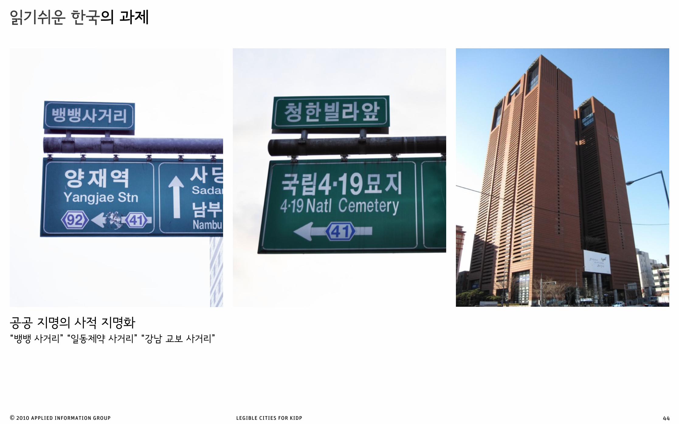
공공 지명의 사적 지명화“뱅뱅 사거리” “일동제약 사거리” “강남 교보 사거리”
읽기쉬운 한국의 과제
44

© 2010 applied information group legible cities for kidp
세계 어느 도시보다 빠르게 변하고 있는 한국에서 어떻게 효과적으로 정보 표시 시스템을 관리할 것인가
읽기쉬운 한국의 과제
45
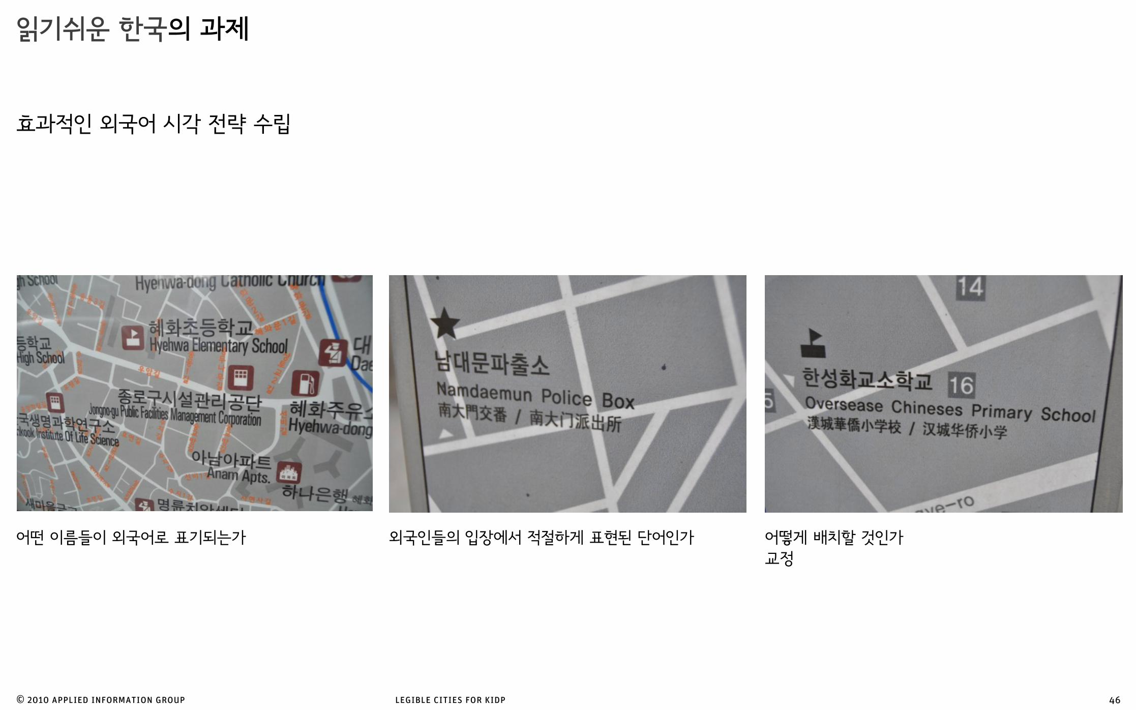
효과적인 외국어 시각 전략 수립
© 2010 applied information group legible cities for kidp
읽기쉬운 한국의 과제
46
어떻게 배치할 것인가 교정
어떤 이름들이 외국어로 표기되는가 외국인들의 입장에서 적절하게 표현된 단어인가

고층 상권은 효과적인 지도 표기를 어렵게 함
© 2010 applied information group legible cities for kidp
2층 3층에도 상권이 형성되어 있고 따라서 2층 3층에도 지리 정보가 쌓여있는 한국의 특성상 이에 걸맞는 정보 표시 형식 방안 고민
읽기쉬운 한국의 과제
47

© 2010 applied information group legible cities for kidp
읽기쉬운 한국의 과제
48
정보 표시 시스템의 컨트롤 타워
설치하는 표시판 만큼 제거하는 표지판도 있어야
레지블 런던 19개 설치하면서 40개 제거
브리스톨에서는 200개 제거
8/8