2010 Census - Census Tract Reference Map · Round Lk Elizabeth Lk Joslin Lk B a r t o ... Unadilla...
1
1 2 Sand Lk R a isin R iv Clarks Lk U n i on Lk Grass Lk Goose Lk West Lk Sa l i n e R i v Raisin R i v Walled Lk Devils Lk Round Lk Elizabeth Lk Joslin Lk Ba r t o n L k H u ro n Riv H uro n R iv Pine Lk Portage Riv Center Lk G r a n d R i v Gr a n d R i v Cass Lk R i v e r Ra is i n R i v e r R a i s i n Lk Erie R iv e r Ra i s i n G r a n d R i v Ore Lk H u r o n R iv Orchard Lk Wamplers Lk Silve r L k Portage Lk Ri v e r R a i s i n K e nt L k P l u m C r k Salin e R i v Big Wolf Lk H ur o n R iv Ford Lk Dexter twp 22180 Lyndon twp 49780 Manchester twp 50680 Northfield twp 58280 Superior ctwp 77560 York ctwp 89100 Saline twp 71160 Sharon twp 72760 Sylvan twp 77800 Ypsilanti ctwp 89160 Augusta ctwp 04180 Webster twp 85100 Salem twp 71130 Bridgewater twp 10560 Freedom twp 30520 Lima twp 47460 Lodi twp 49120 Pittsfield ctwp 64560 Ann Arbor ctwp 03020 Scio twp 71940 Southfield twp Summerfield twp Bedford twp Erie twp Exeter twp Frenchtown twp Ida twp London twp Milan twp Green Oak twp Hamburg twp Norvell twp Rives twp Summit twp Waterloo twp Pittsford twp Somerset twp Wheatland twp Leslie twp Locke twp Alaiedon twp Vevay twp Williamstown twp Northville twp Sumpter twp Madison ctwp Blackman ctwp Grass Lake ctwp Blissfield twp Cambridge twp Clinton twp Deerfield twp Dover twp Palmyra twp Liberty twp Meridian ctwp Brownstown ctwp Canton ctwp Plymouth ctwp Van Buren ctwp Highland ctwp Lyon ctwp Waterford ctwp White Lake ctwp Bloomfield ctwp Berlin ctwp Handy twp Hartland twp Howell twp Oceola twp Putnam twp Unadilla twp Adrian twp Columbia twp Henrietta twp Leoni twp Napoleon twp Huron ctwp Redford ctwp Commerce ctwp Milford ctwp West Bloomfield ctwp Monroe ctwp Raisin twp Ridgeway twp Rollin twp Rome twp Tecumseh twp Woodstock twp Iosco twp Marion twp Novi twp Raisinville twp Ash twp Dundee twp La Salle twp Brighton twp Genoa twp Bunker Hill twp Ingham twp Leroy twp Stockbridge twp Wheatfield twp White Oak twp Franklin twp Hudson twp Macon twp WASHTEN AW 1 61 OAKLAND 125 LENAWEE 091 WASHTENAW 161 LIVINGSTON 093 WASHTENAW 161 WASHTENAW 161 WAYNE 163 JACKSON 075 LENAWEE 091 WASHTENAW 161 MONROE 1 1 5 JACKSON 075 WASHTENAW 161 INGHAM 065 LIVINGSTON 093 INGHAM 065 J ACKSON 075 OAKLAND 125 L I V I N GS T O N 0 9 3 LENAWEE 091 MO N R O E 1 1 5 LENAWEE 091 HILLSDALE 059 WAYNE 163 OAKLAND 125 MONROE 115 WAYNE 163 JACKSON 075 HILLSDALE 059 Whitmore Lake 87060 Vineyard Lake Napoleon Manitou Beach-Devils Lake Michigan Center Woodland Beach Detroit Beach West Monroe South Monroe Okemos Vandercook Lake Whitmore Lake Dexter 22160 Barton Hills 05660 Manchester 50660 Milan° 53920 Ypsilanti° 89140 Saline° 71140 Chelsea° 15020 Ann Arbor° 03000 Flat Rock° Detroit° Dearborn Heights° Dearborn° Taylor° Williamston° Jackson° South Lyon° Southfield° Pontiac° Novi° Bloomfield Hills° Auburn Hills° Milan° Tecumseh° Hudson° Garden City° Belleville° Northville° Westland° Wayne° Romulus° Plymouth° Livonia° Inkster° Wixom° Walled Lake° Sylvan Lake° Orchard Lake Village° Keego Harbor° Farmington Hills° Farmington° Adrian° Howell° Brighton° Petersburg° Monroe° Blissfield Clinton Beverly Hills South Rockwood Bingham Farms Clayton Britton Addison Pinckney Fowlerville Onsted Deerfield Cement City Webberville Stockbridge Dansville Grass Lake Brooklyn Maybee Dundee Carleton Wolverine Lake Milford Franklin 94 94 75 75 696 696 96 96 96 96 94 75 75 94 94 275 275 96 59 59 52 5 5 5 5 36 36 36 36 36 14 153 14 14 14 14 23 23 23 23 23 23 12 12 127 127 12 12 12 12 127 127 23 23 223 223 LEGEND SYMBOL DESCRIPTION SYMBOL LABEL STYLE Federal American Indian Reservation L'ANSE RES 1880 Off-Reservation Trust Land, Hawaiian Home Land T1880 Oklahoma Tribal Statistical Area, Alaska Native Village Statistical Area, Tribal Designated Statistical Area KAW OTSA 5340 State American Indian Reservation Tama Res 4125 State Designated Tribal Statistical Area Lumbee STSA 9815 Alaska Native Regional Corporation NANA ANRC 52120 State (or statistically equivalent entity) NEW YORK 36 County (or statistically equivalent entity) ERIE 029 Minor Civil Division (MCD) 1,2 Bristol town 07485 Consolidated City MILFORD 47500 Incorporated Place 1,3 Davis 18100 Census Designated Place (CDP) 3 Incline Village 35100 Census Tract 33.07 DESCRIPTION SYMBOL DESCRIPTION SYMBOL Interstate 3 U.S. Highway 2 State Highway 4 Other Road Marsh Ln 4WD Trail, Stairway, Alley, Walkway, or Ferry Raiload Southern RR Pipeline or Power Line Ridge or Fence Property Line Nonvisible Boundary or Feature Not Elsewhere Classified Water Body Pleasant Lake Swamp or Marsh Okefenokee Swamp Glacier Bering Glacier Military Fort Belvoir National or State Park, Forest, or Recreation Area Yosemite NP Inset Area A Outside Subject Area Where state, county, and/or MCD boundaries coincide, the map shows the boundary symbol for only the highest-ranking of these boundaries. 1 A ' ° ' following an MCD name denotes a false MCD. A ' ° ' following a place name indicates that a false MCD exists with the same name and FIPS code as the place; the false MCD label is not shown. 2 MCD boundaries are shown in the following states in which MCDs have functioning governments: Connecticut, Maine, Massachusetts, Michigan, Minnesota, New Hampshire, New Jersey, New York, Pennsylvania, Rhode Island, Vermont, and Wisconsin. 3 Place label color correlates to the place fill color. USCENSUSBUREAU Location of County within State 2010 CENSUS TRACT REF MAP (INDEX) 205426161000 INDEX SHEET 42.691185N 84.394737W 42.665393N 83.239831W 41.812969N 83.282388W 41.838419N 84.42109W All legal boundaries and names are as of January 1, 2010. The boundaries shown on this map are for Census Bureau statistical data collection and tabulation purposes only; their depiction and designation for statistical purposes does not constitute a determination of jurisdictional authority or rights of ownership or entitlement. U.S. DEPARTMENT OF COMMERCE Economics and Statistics Administration U.S. Census Bureau Geographic Vintage: 2010 Census (reference date: January 1, 2010) Data Source: U.S. Census Bureau's MAF/TIGER database (TAB10ST26) Map Created by Geography Division: December 14, 2010 ENTITY TYPE: County or statistically equivalent entity NAME: Washtenaw County (161) Projection: Albers Equal Area Conic Datum: NAD 83 Spheroid: GRS 80 1st Standard Parallel: 42 47 51 2nd Standard Parallel: 47 12 16 Central Meridian: -86 16 13 Latitude of Projection's Origin: 41 41 45 False Easting: 0 False Northing: 0 Total Sheets: 3 - Index Sheets: 1 - Parent Sheets: 2 - Inset Sheets: 0 ST: Michigan (26) 0 3 6 9 12 15 Kilometers 15 Kilometers 0 2 4 6 8 10 Miles 10 Miles The plotted map scale is 1:129698 2010 CENSUS - CENSUS TRACT REFERENCE MAP: Washtenaw County, MI
Transcript of 2010 Census - Census Tract Reference Map · Round Lk Elizabeth Lk Joslin Lk B a r t o ... Unadilla...
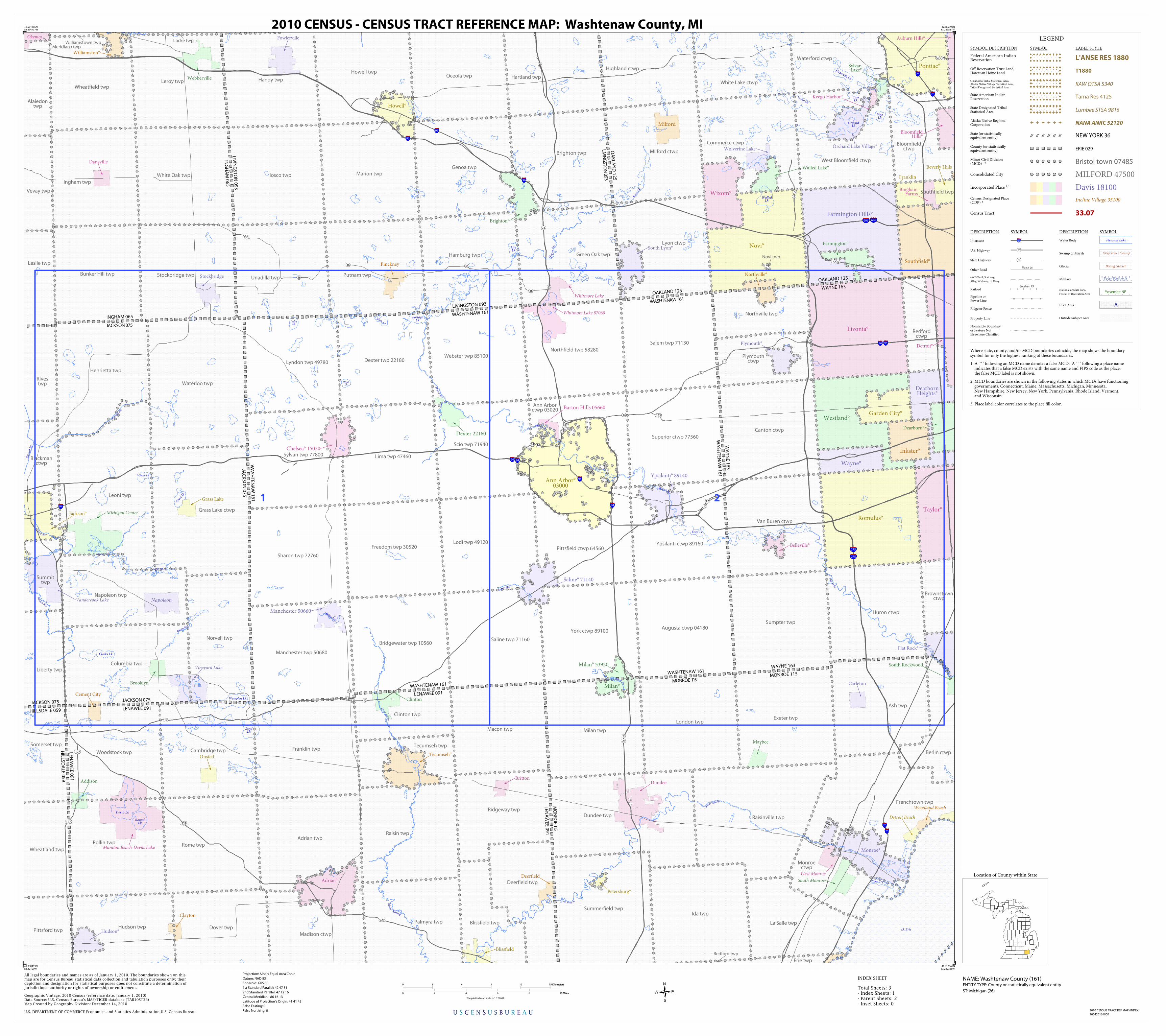
1 2
SandLk
Raisin Riv
Clarks Lk
Union Lk
Gra
ss L
k
Goose Lk
WestLk
Saline Riv
Raisin Riv
WalledLk
Devils Lk
RoundLk
Elizabeth Lk
JoslinLk
Barton Lk
Huron
Riv
Huron Riv
PineLk
Porta
ge R
iv
Center Lk
Gra
n d Riv
Gran
d R iv
CassLk
Ri ver R
aisin
R
iv
er Raisin
Lk Erie
River
Raisin
Gra
nd R
iv
OreLk
Hu
ron Riv
OrchardLk
Wamplers Lk
Silver Lk
PortageLk
River Rai s in
K
ent L
k
P lum Crk
Saline Riv
Big Wolf Lk
Hur
on R
iv
Ford Lk
Dexter twp 22180Lyndon twp 49780
Manchester twp 50680
Northfield twp 58280
Superior ctwp 77560
York ctwp 89100
Saline twp 71160
Sharon twp 72760
Sylvan twp 77800
Ypsilanti ctwp 89160
Augusta ctwp 04180
Webster twp 85100
Salem twp 71130
Bridgewater twp 10560
Freedom twp 30520
Lima twp 47460
Lodi twp 49120Pittsfield ctwp 64560
Ann Arborctwp 03020
Scio twp 71940
Southfield twp
Summerfield twp
Bedford twp
Erie twp
Exeter twp
Frenchtown twp
Ida twp
London twp
Milan twp
Green Oak twpHamburg twp
Norvell twp
Rivestwp
Summittwp
Waterloo twp
Pittsford twp
Somerset twp
Wheatland twp
Leslie twp
Locke twp
Alaiedontwp
Vevay twp
Williamstown twp
Northville twp
Sumpter twp
Madison ctwp
Blackmanctwp
Grass Lake ctwp
Blissfield twp
Cambridge twp
Clinton twp
Deerfield twp
Dover twpPalmyra twp
Liberty twp
Meridian ctwp
Brownstownctwp
Canton ctwp
Plymouthctwp
Van Buren ctwp
Highland ctwp
Lyon ctwp
Waterford ctwp
White Lake ctwp
Bloomfieldctwp
Berlin ctwp
Handy twpHartland twp
Howell twpOceola twp
Putnam twpUnadilla twp
Adrian twp
Columbia twp
Henrietta twp
Leoni twp
Napoleon twp
Huron ctwp
Redfordctwp
Commerce ctwp
Milford ctwp
West Bloomfield ctwp
Monroectwp
Raisin twp
Ridgeway twp
Rollin twp Rome twp
Tecumseh twp
Woodstock twp
Iosco twp Marion twp
Novi twp
Raisinville twp
Ash twp
Dundee twp
La Salle twp
Brighton twp
Genoa twp
Bunker Hill twp
Ingham twp
Leroy twp
Stockbridge twp
Wheatfield twp
White Oak twp
Franklin twp
Hudson twp
Macon twp
WASHTENAW 161
OAKLAND 125
LENAWEE 091
WASHTENAW 161
LIVINGSTON 093
WASHTENAW 161
WA
SH
TE
NA
W 1
61
WA
YN
E 1
63
JACKSON 075
LENAWEE 091
WASHTENAW 161
MONROE 115
JAC
KS
ON
07
5
WA
SH
TE
NA
W 1
61
ING
HA
M 0
65
LIVIN
GS
TO
N 0
93
INGHAM 065
JACKSON 075
OA
KLA
ND
12
5
LIVIN
GST
ON
093
LEN
AW
EE
09
1
MO
NR
OE 115
LEN
AW
EE
09
1
HILLS
DA
LE 0
59
WAYNE 163
OAKLAND 125
MONROE 115
WAYNE 163
JACKSON 075
HILLSDALE 059
Whitmore Lake 87060
Vineyard Lake
Napoleon
Manitou Beach-Devils Lake
Michigan Center
Woodland Beach
Detroit Beach
West Monroe
South Monroe
Okemos
Vandercook Lake
Whitmore Lake
Dexter 22160
Barton Hills 05660
Manchester 50660
Milan° 53920
Ypsilanti° 89140
Saline° 71140
Chelsea° 15020
Ann Arbor°03000
Flat Rock°
Detroit°
DearbornHeights°
Dearborn°
Taylor°
Williamston°
Jackson°
South Lyon°
Southfield°
Pontiac°
Novi°
BloomfieldHills°
Auburn Hills°
Milan°
Tecumseh°
Hudson°
Garden City°
Belleville°
Northville°
Westland°
Wayne°
Romulus°
Plymouth°
Livonia°
Inkster°
Wixom°
Walled Lake°
SylvanLake°
Orchard Lake Village°
Keego Harbor°
Farmington Hills°
Farmington°
Adrian°
Howell°
Brighton°
Petersburg°
Monroe°
Blissfield
Clinton
Beverly Hills
South Rockwood
BinghamFarms
Clayton
BrittonAddison
Pinckney
Fowlerville
Onsted
Deerfield
Cement City
Webberville
Stockbridge
Dansville
Grass Lake
Brooklyn
Maybee
Dundee
Carleton
Wolverine Lake
Milford
Franklin
94 94
75
75
696696
96
96
96 96
94
75
75
94
94
275
275
96
5959
52
5
5
55
36
36
3636
36
14
15314
14
14 14
23
23
23
23
23
23
12
12
127
127
121212
12
127
127
23
23
223
223
LEGEND
SYMBOL DESCRIPTION SYMBOL LABEL STYLE
Federal American IndianReservation L'ANSE RES 1880
Off-Reservation Trust Land,Hawaiian Home Land T1880
Oklahoma Tribal Statistical Area,Alaska Native Village Statistical Area,Tribal Designated Statistical Area
KAW OTSA 5340
State American IndianReservation Tama Res 4125
State Designated TribalStatistical Area Lumbee STSA 9815
Alaska Native RegionalCorporation NANA ANRC 52120
State (or statisticallyequivalent entity) NEW YORK 36
County (or statisticallyequivalent entity) ERIE 029
Minor Civil Division(MCD)1,2 Bristol town 07485
Consolidated City MILFORD 47500
Incorporated Place 1,3 Davis 18100Census Designated Place(CDP) 3 Incline Village 35100
Census Tract 33.07
DESCRIPTION SYMBOL DESCRIPTION SYMBOL
Interstate 3
U.S. Highway 2
State Highway 4
Other RoadMarsh Ln
4WD Trail, Stairway,
Alley, Walkway, or Ferry
RailoadSouthern RR
Pipeline orPower Line
Ridge or Fence
Property Line
Nonvisible Boundaryor Feature NotElsewhere Classified
Water Body Pleasant Lake
Swamp or Marsh Okefenokee Swamp
Glacier Bering Glacier
Military Fort Belvoir
National or State Park,
Forest, or Recreation AreaYosemite NP
Inset Area A
Outside Subject Area
Where state, county, and/or MCD boundaries coincide, the map shows the boundarysymbol for only the highest-ranking of these boundaries.
1 A ' ° ' following an MCD name denotes a false MCD. A ' ° ' following a place name indicates that a false MCD exists with the same name and FIPS code as the place; the false MCD label is not shown.
2 MCD boundaries are shown in the following states in which MCDs have functioning governments: Connecticut, Maine, Massachusetts, Michigan, Minnesota, New Hampshire, New Jersey, New York, Pennsylvania, Rhode Island, Vermont, and Wisconsin.
3 Place label color correlates to the place fill color.
U S C E N S U S B U R E A U
Location of County within State
2010 CENSUS TRACT REF MAP (INDEX)
205426161000
INDEX SHEET
42.691185N84.394737W
42.665393N83.239831W
41.812969N83.282388W
41.838419N84.42109W
All legal boundaries and names are as of January 1, 2010. The boundaries shown on thismap are for Census Bureau statistical data collection and tabulation purposes only; theirdepiction and designation for statistical purposes does not constitute a determination ofjurisdictional authority or rights of ownership or entitlement.
U.S. DEPARTMENT OF COMMERCE Economics and Statistics Administration U.S. Census Bureau
Geographic Vintage: 2010 Census (reference date: January 1, 2010)Data Source: U.S. Census Bureau's MAF/TIGER database (TAB10ST26)Map Created by Geography Division: December 14, 2010
ENTITY TYPE: County or statistically equivalent entity
NAME: Washtenaw County (161) Projection: Albers Equal Area Conic
Datum: NAD 83
Spheroid: GRS 80
1st Standard Parallel: 42 47 51
2nd Standard Parallel: 47 12 16
Central Meridian: -86 16 13
Latitude of Projection's Origin: 41 41 45
False Easting: 0
False Northing: 0
Total Sheets: 3- Index Sheets: 1- Parent Sheets: 2- Inset Sheets: 0
ST: Michigan (26)
0 3 6 9 12 15 Kilometers15 Kilometers
0 2 4 6 8 10 Miles10 Miles
The plotted map scale is 1:129698
2010 CENSUS - CENSUS TRACT REFERENCE MAP: Washtenaw County, MI