201 McMurray Formation Geology - CCG · A Review of McMurray Formation Geology in Athabasca Oil...
8
Paper 201, CCG Annual Report 11, 2009 (© 2009) 201-1 A Review of McMurray Formation Geology in Athabasca Oil Sands Rahman M. Hassanpour The Northern Alberta oil sands, containing the Athabasca, Peace River and Cold Lakes areas, are the largest oil sands deposits in the world that cover a surface area of more than 140,200 km2 with an estimated initial oil in place of 1.7 trillion barrels (Government of Alberta, 2007). Athabasca oil sands deposit is considered the single largest hydrocarbon reservoir in the world (DeMaison, 1977). McMurray formation, which is the oil bearing formation in Athabasca oil sands area, is known for its complex geological heterogeneity. The majority of the heavy oil deposits in the Athabasca oil sands are exist within fluvial-estuarine channel point bar deposits of the Lower Cretaceous McMurray Formation. The McMurray Formation belongs to Mannville Group of northern Alberta. The lower part of the Mannville Group contains the McMurray Formation and the upper part contains the Wabiskaw member, Clearwater Formation and the Grand Rapids Formations (see Figure 2). The overburden thickness in Athabasca deposits varies from 0m in outcrops along the Athabasca River up to more than 450m at the southwest of the deposit and the thickness of the lower Mannville Group (McMurray Formation) varies from 0m up to more than 110m (Ranger and Gingras, 2003). McMurray Formation was deposited directly on top of the Devonian evaporates and carbonates with a sharp contact of an unconformity surface. Before the deposition of McMurray Formation, the Devonian carbonate was eroded and a broad north-westerly trending valley known as McMurray sub- basin was created. It was surrounded by Precambrian Shield on the east and the carbonate of Grosmont Formation on the west (Stewart and MacCallum, 1987). The deposition of the McMurray Formation was happened in this valley as a response to the rise of the Cretaceous Boreal Sea to the north in very early Albian (Flach, 1984). Figure 3 shows the Isopach map of the McMurray Formation and the northwesterly axis of McMurray Valley system. The variety of deposition environments in the McMurray Formation leads to development of a highly complex heterogeneous oil reservoir. Prior to describing the stratigraphy and sedimentologic interpretations of McMurray Formation, a brief review of the estuarine environment, the dominant environment in deposition of McMurray Formation, will be discussed. Estuarine Environment An estuary is defined as the seaward portion of a drowned valley system which receives sediment from both fluvial and marine sources and which contains facies influenced by tide, wave and fluvial process (Dalrymple et al., 1992). If the sediment is supplied mostly from the fluvial part the site called as a delta and if the sediment is delivered to the area only by marine process the environment is known as a prograding coast. Dalrymple et al. (1992) divided the estuaries into two major groups of wave-dominated and tide-dominated estuaries based on the relative influence of waves and tides. In the wave-dominated estuaries, tidal influence is small and the mouth of the system is dominated by relatively high wave energy which pushes sediments to move alongshore or onshore into the mouth of the estuary and develop a sub-aerial barrier. This distribution of energy generates a three- fold lithofacies within a wave-dominated estuary. A marine sand body deposits at the estuary mouth. It mainly contains transgressive sub-tidal washover deposits. Coarse grain sand is also deposited at the head of estuary by the river. The middle part of wave-dominated estuaries contains extensive salt marshes and is crossed by tidal channels (Dorjes and Howard, 1975). Tide-dominated estuaries are generated if the wave action is limited and/or the tidal prism is large (Hayes, 1979). In this case the tidal current energy is dominated at the mouth of estuary and elongate sand bars are typically developed. Moving upstream from these sand bars, the main channel typically narrows and a straight-meandering-straight progression of channel sinuosity is appeared. In the meandering part of tide-dominated estuaries, the finest channel sands are deposited. The muddy sediments are also accumulated in tidal flats and marshes along the sides of the estuary (Dalrymple et al., 1992). Figure 4 shows the plan view and cross sectional view of wave and tide dominated estuaries.
-
Upload
trinhkhuong -
Category
Documents
-
view
221 -
download
0
Transcript of 201 McMurray Formation Geology - CCG · A Review of McMurray Formation Geology in Athabasca Oil...

Paper 201, CCG Annual Report 11, 2009 (© 2009)
201-1
A Review of McMurray Formation Geology in Athabasca Oil Sands
Rahman M. Hassanpour
The Northern Alberta oil sands, containing the Athabasca, Peace River and Cold Lakes areas, are the
largest oil sands deposits in the world that cover a surface area of more than 140,200 km2 with an
estimated initial oil in place of 1.7 trillion barrels (Government of Alberta, 2007). Athabasca oil sands
deposit is considered the single largest hydrocarbon reservoir in the world (DeMaison, 1977). McMurray
formation, which is the oil bearing formation in Athabasca oil sands area, is known for its complex
geological heterogeneity.
The majority of the heavy oil deposits in the Athabasca oil sands are exist within fluvial-estuarine
channel point bar deposits of the Lower Cretaceous McMurray Formation. The McMurray Formation
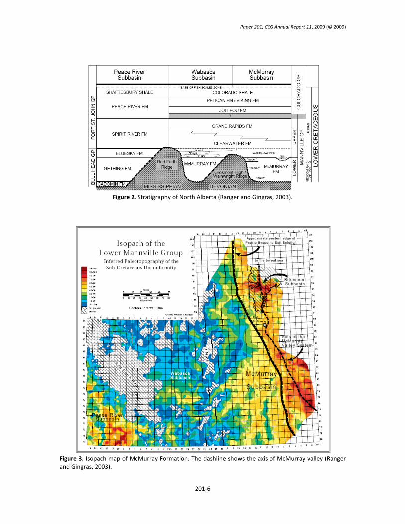
belongs to Mannville Group of northern Alberta. The lower part of the Mannville Group contains the
McMurray Formation and the upper part contains the Wabiskaw member, Clearwater Formation and the
Grand Rapids Formations (see Figure 2). The overburden thickness in Athabasca deposits varies from 0m
in outcrops along the Athabasca River up to more than 450m at the southwest of the deposit and the
thickness of the lower Mannville Group (McMurray Formation) varies from 0m up to more than 110m
(Ranger and Gingras, 2003).
McMurray Formation was deposited directly on top of the Devonian evaporates and carbonates
with a sharp contact of an unconformity surface. Before the deposition of McMurray Formation, the
Devonian carbonate was eroded and a broad north-westerly trending valley known as McMurray sub-
basin was created. It was surrounded by Precambrian Shield on the east and the carbonate of Grosmont
Formation on the west (Stewart and MacCallum, 1987). The deposition of the McMurray Formation was
happened in this valley as a response to the rise of the Cretaceous Boreal Sea to the north in very early
Albian (Flach, 1984). Figure 3 shows the Isopach map of the McMurray Formation and the northwesterly
axis of McMurray Valley system. The variety of deposition environments in the McMurray Formation
leads to development of a highly complex heterogeneous oil reservoir.
Prior to describing the stratigraphy and sedimentologic interpretations of McMurray Formation,
a brief review of the estuarine environment, the dominant environment in deposition of McMurray
Formation, will be discussed.
Estuarine Environment
An estuary is defined as the seaward portion of a drowned valley system which receives sediment from
both fluvial and marine sources and which contains facies influenced by tide, wave and fluvial process
(Dalrymple et al., 1992). If the sediment is supplied mostly from the fluvial part the site called as a delta
and if the sediment is delivered to the area only by marine process the environment is known as a
prograding coast. Dalrymple et al. (1992) divided the estuaries into two major groups of wave-dominated
and tide-dominated estuaries based on the relative influence of waves and tides.
In the wave-dominated estuaries, tidal influence is small and the mouth of the system is
dominated by relatively high wave energy which pushes sediments to move alongshore or onshore into
the mouth of the estuary and develop a sub-aerial barrier. This distribution of energy generates a three-
fold lithofacies within a wave-dominated estuary. A marine sand body deposits at the estuary mouth. It
mainly contains transgressive sub-tidal washover deposits. Coarse grain sand is also deposited at the head
of estuary by the river. The middle part of wave-dominated estuaries contains extensive salt marshes and
is crossed by tidal channels (Dorjes and Howard, 1975).
Tide-dominated estuaries are generated if the wave action is limited and/or the tidal prism is
large (Hayes, 1979). In this case the tidal current energy is dominated at the mouth of estuary and
elongate sand bars are typically developed. Moving upstream from these sand bars, the main channel
typically narrows and a straight-meandering-straight progression of channel sinuosity is appeared. In the
meandering part of tide-dominated estuaries, the finest channel sands are deposited. The muddy
sediments are also accumulated in tidal flats and marshes along the sides of the estuary (Dalrymple et al.,
1992). Figure 4 shows the plan view and cross sectional view of wave and tide dominated estuaries.

Paper 201, CCG Annual Report 11, 2009 (© 2009)
201-2
Stratigraphy and Sedimentology of McMurray Formation
Carrigy (1959) believed that the McMurray Formation can be better interpreted with three stratigraphy
subdivisions consisting of lower fluvial succession, middle estuarine and point bar succession and upper
coastal plain units. This idea developed more with other studies of outcrops and cores in the McMurray
Formation (Stewart and MacCallum, 1978; Flach, 1984; Ranger and Gingras, 2003). However, some
researchers (Hein et al., 2000; Hein and Dolby, 2001) prefer to use two fold McMurray Formation
description because they believe that the distinctions between the middle and upper McMurray are not
possible on a regional scale and the observed differences in outcrops may reflect a predictable change
upsection from estuarine to more marine conditions.
Lower McMurray
The Lower McMurray unit mainly contains massive or high angle fine to coarse pebbly sands and
considered to be deposited within the fluvial environment. There are some indicators (rare bioturbation,
presence of rooted and coal horizons) that the fluvial systems of the lower McMurray unit have been the
upper part of a greater estuarine system (Ranger and Gingras, 2003). The lower McMurray is dominated
with sandy IHS which becomes muddier upwards.
Upper McMurray
The Upper Unit of the McMurray Formation is known by horizontal strata which are often in sharp
contrast to Inclined Heterolithic Strata (IHS) beds of the middle McMurray. There are two coarsening-
upward units (Red and Blue cycle) in the upper McMurray formation which are separated by a thin unit
referred to as the Green unit (Ranger and Gingras, 2003). Within each coarsening-upward cycle, three
lithofacies are present. The vertical arrangement of lithofacies represents the superposition of proximal
through distal shoreface environments. An erosion surface, that separates the McMurray Formation from
the overlying Wabiskaw member, has likely removed the coastal plain succession in the northern region
of Athabasca oil sand deposits (Hein et al., 2000).
Middle McMurray
Middle unit of the McMurray Formation is the thickest part and contains the best reservoir sands.
Regionally the McMurray Formation contains fluvial, open estuarine and estuarine channel complex
deposit. The deposit of the middle McMurray member can be described as a depositional environment
within a tidally influenced middle to outer estuarine system. Beside the abandoned channel-fill facies
which are predominated by mud and considered as permeability barriers, there are two distinct reservoir
facies associations available in the middle McMurray unit.
Large-scale Cross-stratified Sand
The first facies association is the large scale cross-stratified coarse sand which is characterized by
excellent porosity and permeability and high bitumen saturation. This facies association consists of
bedsets up to 0.5 m or more in thickness with strong tidal indicators (reverse flow ripples, reactivation
surfaces,…) (Ranger and Gingras, 2003). Top of this facies association is normally truncated and may be
capped by a thin shale lamina. At the first glance it seems to be part of a high flow regime fluvial channel
deposit however the iconology of outcrops and cores shows that it was originated in marine environment.
Ranger and Gingras (2003) suggested considering this facies in the lower (outer) estuary proximal to the
estuary mouth. The clean sand of this facies association is the most desirable reservoir facies.
Inclined Heterolithic Stratification
Thomas et al. (1987) described the heterogeneous deposits with notable primary dip as the term Inclined
Heterolithic Stratification (IHS). They proposed that IHS form as a result of the lateral growth of active,
large-scale bedsets such as point bars or Gilbert-type deltas but according to their extensive study of
several ancient and modern IHS deposits they concluded that the majority of IHS deposits are products of
point bar lateral accretion within meandering channel of freshwater rivers, tidally influenced rivers and
creeks draining intertidal mudflats.
IHS packages consist of inclined repetitive sets of decimeter to meter thick couplets of sand and
mud. IHS varies in contents from those dominated by clean sand to those composed almost of mud.
Individual sand and shale are known from outcrop to be laterally continuous from top of a facies unit to

Paper 201, CCG Annual Report 11, 2009 (© 2009)
201-3
near the base. The mud clast breccia can also be found at the bottom of a channel succession as a result
of erosion of previously deposited muddy point bars and overbank collapse. Figure 4 shows a schematic of
IHS deposit in a meandering channel.
The second facies association of the middle McMurray Formation consists of complex sets of
Inclined Heterolithic Stratification (IHS). It is always appears on top of the massive cross-stratified sand of
first facies association (Ranger and Gingras, 2003). A detailed understanding of IHS deposits of the middle
McMurray Formation has been of particular interest of many researchers because these heterogeneous
elements play an important role in development of in-situ processes. Several researches have been
undertaken on this area.
Carrigy (1971) interpreted IHS within the McMurray Formation as foreset deposits of small,
Gilbert-type deltas prograding northward into a standing lacustrine or lagoonal body. Mossop and Flach
(1983) proposed deposition of IHS under the deep meandering fluvial channels environment. Based on
the study on the core and outcrops, they proposed the incised valley fills model for two facies associations
of middle McMurray Formation. They believed that both the massive cross-stratified sand and the IHS
complex are sub-environment of the same system tract. The megaripple bedded sands that typically
underlie the IHS in outcrop have been interpreted as large scale bedforms that migrated on the channel
bed.
However, there are some indicators (fining-upward succession and indicators of brackish water
conditions) that support the idea of deposition within a channelized central estuarine environment which
was first introduced by Stewart and MacCallum (1978). They believe that under the transgressive system,
the sea level was repeatedly raised and fallen and changed the environment from fluvial to estuarine.
This idea was later supported by work of Pemberton et al. (1982), Smith (1987), and Rangers and Gingras
(2003). Based on this idea, the architectural relationship between large scale cross-stratified sand and the
IHS bedsets is explained by linking them as depositional elements of a tide-dominated delta that
originated in the valley low and prograded basinward. Thus the cross-stratified sand represents strongly
tidal-influenced outer estuarine sediments, and IHS bedsets middle estuarine distributary channels.
Stacking of two or more IHS sets is common in the McMurray Formation. The normal thickness of a single
IHS set in the McMurray Formation has been reported to vary between 8 to 25m within the channels with
20 to 45 m thick. Dip angle of IHS beds in McMurray Formation are seen to vary from 4 to 22 (Smith,
1988; Rahmani, 1988; Mossop and Flach, 1983).
The sedimentologic and ichnologic character of IHS packages vary considerably within the
estuarine system of McMurray Formation. Lettley (2004) characterized and classified the IHS packages
within the estuarine system of McMurray Formation based on Sedimentology and ichnology character of
IHS. According to this study there is a tripartite distribution of IHS, with a sand-dominated seaward flux in
the upper reach, a fine-grained zone of convergent flux in the middle reach, and sand-dominated
landward flux in the lower reach. The sand dominated IHS deposits from each end of the system contrast
strongly in terms of texture, structure, biogenic signature, and stratal organization. Similarly, fine
members from the central portion of the system exhibit a progression of character from dense mud to
finely interlaminated silt/sand and mud in a landward direction.
The sand bars in the tidally influences meandering channel of middle McMurray estuary are the
most important oil sand reservoir in the Athabasca oil sand deposit. Tidal effects insert complexity in the
sand bars in the estuary system. A study (Dalrymple and Rhodes, 1995) on the morphology of estuarine
point bar shows that there are different sand bars in the estuarine system; repetitive barforms which
occur in tidal channel and creeks of estuary, elongate tidal bars which are features characteristic of the
outer part of macrotidal estuaries but are also observed at the mouth of estuaries with smaller tidal
ranges, and delta like bodies which are isolated features typically forming where a channel widens
considerably.
There are intrinsic differences between the morphology and sedimentary of tide-dominated
channels and completely fluvial channels. The deposits in tidal channels are finer grained than in a fluvial
channel. The stability of tidal channels subject to tidal flow dynamics is more than the fluvial channels and
occurrence of channel abandonment by chute cut-off and avulsion is lower in tidal channels because of
higher water elevation and lower velocity. Channels in fluvial setting are much deeper than the tidal
channels. Development of levee and crevasse in the tidal channels are rare or absent (Barwis, 1978).

Paper 201, CCG Annual Report 11, 2009 (© 2009)
201-4
Analysis of new field observations on the geometry of meandering tidal channels reveals that the
values of meander wavelengths as well as curvatures, conveniently scaled by local channel width, fall
within a fairly restricted range, suggesting the existence of some mechanistic process controlling meander
formation (Solari et al., 2002).
Summary
Majority of the heavy oil deposits in the Athabasca oil sands are exist within fluvial-estuarine channel
point bar deposits of the Lower Cretaceous McMurray Formation. There is an informal threefold
stratigraphy subdivision in the McMurray Formation; a lower fluvial succession, middle estuarine and
point bar succession and upper coastal plain units. Middle unit of the McMurray Formation is the thickest
part and contains the best reservoir sands. There are two distinct reservoir facies associations available in
the middle McMurray unit; the large scale cross-stratified coarse sand which is characterized by excellent
porosity and permeability and high bitumen saturation, and complex sets of Inclined Heterolithic
Stratification (IHS). There are two different interpretation of the middle McMurray succession. The deep
channel model implies that the entire succession from the base of the cross-stratified sands to the top of
the IHS (locally 40 m thick) was deposited by the action of a single, deep meandering channel. Cross-
stratified sand deposition would have taken place at the base of the channel, while IHS was deposited on
a contemporaneous point bar. The incised valley fill model implies that deposition of the succession took
place in stages, as base level rose. The locally present cross-stratified mega-rippled sands would have
been deposited in an outer estuarine sand wave complex after initial inundation of the valley. Subsequent
progradation and aggradation of the estuarine system would lead to deposition of stacked channel
deposits for the remainder of the valley fill.
References
Alberta’s Oil Sands 2006. Alberta Department of Energy, Government of Alberta 2007.
Barwis, J.H., 1978. Sedimentology of some South Carolina tidal creek point bars, and a comparison with their fluvial
counterparts: in Miall, A.D. (ed.), Fluvial sedimentology, Canadian Society of Petroleum Geologists, Memoir #5, 129-
160.
Carrigy, M.A. 1959. Geology of the McMurray Formation, Part III, General Geology of the McMurray area, Alberta
Research Council, Memoir I, 130 p.
Dalrymple, R.W., B.A. Zaitlin and R. Boyd, 1992. Estuarine facies models – Conceptual basis and stratigraphic
implications: Journal of Sedimentary Petrology, v. 62, p. 1130-1146.
Dalrymple, R. W. & Rhodes, R. M. 1995. Estuarine dunes and bars. In Geomorphology and Sedimentology of Estuaries
(ed. G. M. E. Percillo). Developments in Sedimentology, vol. 53, pp. 359-422. Elsevier.
DeMaison, G.J., 1977. Tar sands and supergiant oil fields, American Association of Petroleum Geologist Bulletin, v.61,
no.11, p. 1950-1961.
Dorjes, J. and Howard, J.D., 1975. Estuaries of the Georgia coast, USA: Sedimentology and Biology IV, Fluvial-marine
transition indicators in an estuarine environment, Ogeechee River-Ossabaw Sound: Senckenbergiana Maritima, v. 7,
p. 137-179.
Flach, P.D., 1984. Oil Sands Geology – Athabasca Deposit North, Alberta Research Council Bulletin 46, 31 p.
Hayes, M.O., 1979. Barrier island morphology, in Leatherman, S.P., ed., Barrier Islands from the Gulf of Mexico to the
Gulf of St. Lawrence: New York, Academic Press, p. 1-28.
Hein, F.J., Cotterill, D.K. and Berhane, H., 2000. An Atlas of Lithofacies of the McMurray Formation Athabasca Oil
Sands Deposit, North Alberta: Surface and Subsurface, Alberta Geological Survey, Earth Sciences Report.
Hein, F.J., and Dolby, G., 2001. Regional lithostratigraphy, biostratigraphy and facies models, Athabsca oil sand
deposit, northeast Alberta. Canadian Society of Petroleum Geologists, Program with Abstracts, Rock the Foundation
Convention, Abstract 25, June 18-22.
Mossop, G.D. and P.D. Flach, 1983. Deep channel sedimentation in the Lower Cretaceous McMurray Formation,
Athabasca Oil Sands, Alberta. Sedimentology, 110 v. 30, p. 493-509.
Pemberton, S.G., Flach, P.D. and Mossop, G.D. 1982. Trace fossils from the Athabasca Oil Sands, Alberta, Canada.
Science, v. 217, pp. 825-827.
Rahmani, R.A., 1988. Estuarine tidal channel and nearshore sedimentation of the Late Cretaceous epicontinental sea,
Drumheller, Alberta, Canada: in de Boer, P.L., A. van Gelder and S.D. Nio (eds.), Tide-influenced sedimentary
environments and facies. Reidel Publishing Company, p. 433-471.
Ranger, M.J., and Gingras, M.K., 2003. Geology of the Athabasca Oil Sands – field guide and overview: Canadian
Society of Petroleum Geologists, Calgary, 123 p.

Paper 201, CCG Annual Report 11, 2009 (© 2009)
201-5
Smith, D.G. 1987. Meandering river point bar lithofacies models: modern and ancient examples compared. In:
Ethridge, F.G., Flores, R.M. and Harvey, M.D. (eds), Recent developments in fluvial sedimentology. Society of
Economic Paleontologists and Mineralogists, Special Publication Number 39, pp. 83-91.
Smith, D.G., 1988. Modern point bar deposits analogous to the Athabasca Oil Sands, Alberta, Canada: in de Boer, P.L.,
A. van Gelder and S.D. Nio (eds.), Tide-influenced sedimentary environments and facies. Reidel Publishing Company,
p. 417-432.
Solari, L., Seminara, G., Lanzoni, S., Marani, M., and Rinaldo, A., 2002. Sand bars in tidal channels: Part 2. Tidal
meanders, Journal of Fluid Mechanics, vol. 451, p. 203-238.
Stewart, G.A. and MacCallum, G.T. 1978. Athabasca Oil Sands guide book. C.S.P.G. international conference, facts and
principles of world oil occurrence, Canadian Society of Petroleum Geologists, Calgary, Alberta, 33 p.
Thomas, R.G., Smith, D.G., Wood, J.M., Visser, J., Calverley-Range, E.A. and Koster, E.H. 1987. Inclined heterolithic
stratification - terminology, description, interpretation and significance. Sedimentary Geology, v. 53, pp. 123-179.
Zaitlin, B.A., Dalrymple, R.W., Boyd, R., Leckie, D., 1994. The Stratigraphic Organization of Incised Valley Systems:
Implications to Hydrocarbon Exploration and Production. Canadian Society of Petroleum Geologists, 189 p.
Figure 1. Location map of main oilsand deposits in Alberta, Canada (Hein et al., 2007).
Paper 201, CCG Annual Report 11, 2009 (© 2009)
201-6
Figure 2. Stratigraphy of North Alberta (Ranger and Gingras, 2003).
Figure 3. Isopach map of McMurray Formation. The dashline shows the axis of McMurray valley (Ranger
and Gingras, 2003).

Paper 201, CCG Annual Report 11, 2009 (© 2009)
201-7
Figure 4. Distribution of morphological elements and sedimentary facies in plan view (top) and cross
sectional view (bottom) for A) Wave-dominated estuary and B) Tide-dominated estuary (modified after
Dalrymple, 1992).
Figure 5. Conceptual Geological Model for McMurray Formation (modified after Ranger and Gingras,
2003).

Paper 201, CCG Annual Report 11, 2009 (© 2009)
201-8
Figure 6. Schematic representation of Inclined Heterolithic Stratification (IHS) deposits in a tidally
influenced channel. a) Plan view of a channel meandering. b) Cross sectional view of IHS and distribution
of sand, mud, and mud clast breccia in the channel (Redrawn from Thomas et al., 1987).
Figure 7. Distribution of point bars in Estuarine environment of middle McMurray Formation (modified
after Lettley, 2004).