2008 Landscape and Visual Impact Assessment
20
-
Upload
scolty-redevelopment -
Category
Documents
-
view
218 -
download
1
description
Detailed report into the impact of future development on the now Sandlaw Farming site, completed by an independent group in 2008.
Transcript of 2008 Landscape and Visual Impact Assessment
PROJECTED DEVELOPMENT AT AUCHATTIE, BANCHORY Landscape and Visual Impact Assessment On behalf of Bancon Developments August 2008
DAVID WILSON ASSOCIATES
la n d s c ap e ar c h i te ct s
121 Cadzow Street, Hamilton ML3 6JA Tel: 01698 200035 Fax: 01698 200036
CONTENTS
1. Introduction................................................................... 1 2. Methodology ................................................................. 2 3. Location and Context .................................................... 3 4. Landscape Character .................................................... 5 5. Description of the Search Area...................................... 8 6. Planning Context .......................................................... 9 7. Visual Analysis............................................................ 10 8. Landscape and Visual Impacts.................................... 13 9. Conclusion.................................................................. 15 References......................................................................... 16 Practice Information............................................................ 17
DAVID WILSON ASSOCIATES landscape architects Aros House, 121 Cadzow Street, Hamilton ML3 6JA
1
1. INTRODUCTION
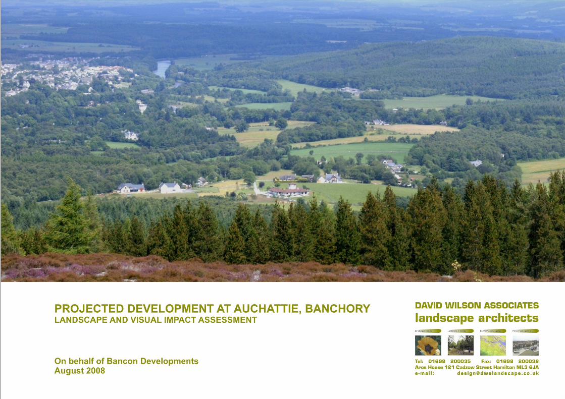
1.1 The area known as Auchattie is on the south bank of the River Dee opposite the town of Banchory. It is within an Area of Landscape Significance and has, over recent years, been the subject of a limited number of small developments.
1.2 It has often been considered as the site for the future expansion of Banchory
but has always been rejected by Aberdeenshire Council, most recently at the conclusion of the Aberdeenshire Local Plan of 2006, in view of the precedent that would be set in this particularly attractive part of the Aberdeenshire countryside.
1.3 Many developers have looked at this area in the past with a view to
establishing a large new residential development and The Prince’s Foundation for the Built Environment, in association with Scotia Homes, is currently seeking approval for such a development.
1.4 Bancon Homes have commissioned David Wilson Associates to take a
realistic view of the landscape and visual impact of such a major development. 1.5 Since a detailed proposal is not available, the assessment is based on the
general assumption that a complex urban development project will be carried out, resulting in the establishment of a new mixed use district in the usual historic (Victorian) style characteristic of previous projects undertaken by the Foundation. The area concerned may range approximately between 50,000 to 250,000sqm (12 to 62 acres).
DAVID WILSON ASSOCIATES landscape architects Aros House, 121 Cadzow Street, Hamilton ML3 6JA
2
2. METHODOLOGY
2.1. Although an exact site boundary has not yet been specified, a reasonable assumption can be made of the search area. The report starts with a description of the location and context of this area. Elements such as transport links, landscape designations and archaeological features are examined in this section and relevant conclusions drawn.
2.2. In order to establish the setting into which the new development should blend,
the Landscape Character of the area and surroundings are then examined in relation to the "South and Central Aberdeenshire: landscape character assessment", prepared by the Environmental Resources Management in 1998. This document sets out the officially accepted description of the character of the area. Its guidelines for development within this landscape character type are taken into consideration.
2.3. Following this, the physical conditions of the site itself are addressed through
study of the topography, vegetation and built forms. 2.4. The use of the site is governed primarily by the policies of the Structure Plan
and the Local Plan. These are considered in detail, and the appropriate policies listed and their relationship to the proposed site discussed.
2.5. The visual impact of any development of the site is then looked at through a
detailed photographic analysis and determination of the Visual Envelope of the site. The Visual Envelope (envelope of landscape from which any development on the site will be seen) is established using the KeyTERRA-FIRMA modelling programme. An assessment of the more sensitive visual receptors within the area is then undertaken and any issues highlighted.
2.6. Knowing all the relevant information, the potential landscape and visual
impacts are then assessed in detail both during the construction period, as a result of its finished form and during its operation. Possible mitigation of the impacts is also taken into consideration. From these, conclusions are drawn to highlight the most important aspects that can assist judgement of the impacts of the projected development.
2.7. The overall methodology has been undertaken in accordance with the
recommendations of “Guidelines for Landscape and Visual Impact Assessment” published by the Landscape Institute in conjunction with the Institute of Environmental Management and Assessment. In addition to the various printed and electronic sources of information, the study was based on site visits in June and July 2008.
2.8. Although there has not been a separate ecological or tree survey prepared, the character of the vegetation and limiting ecological features have been identified during the site survey.
DAVID WILSON ASSOCIATES landscape architects Aros House, 121 Cadzow Street, Hamilton ML3 6JA
3
3. LOCATION AND CONTEXT
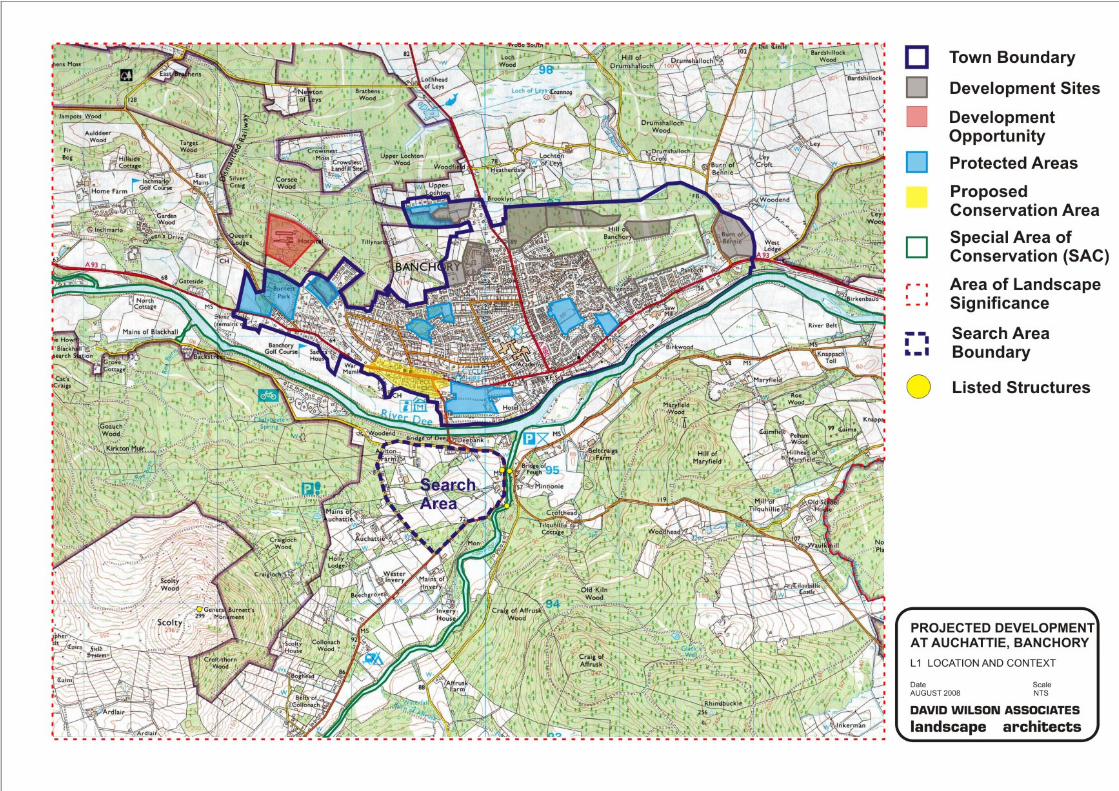
3.1 The search area for the proposed site Auchattie sits in the Dee Valley at Banchory, on the south side of the river (see drawing number L1). This area is situated within the jurisdiction of Aberdeenshire Council and falls within the Feughdee West Community Council area.
3.2 The search area stretches from Deebank, at the head of the Bridge of Dee, to
Auchattie to the southwest, surrounded by the B974 road and two additional country roads. The site is therefore relatively accessible from the centre of Banchory but only across a low capacity bridge.
3.3 This section of the River Dee Valley is enclosed by the Grampian Foothills and
the upland mass of the Mounth. The River Dee provides the southern boundary to much of the developed part of Aberdeenshire west of the City. Banchory also sits upon the northern bank of the river. According to the local plan, the settlement had a population of 6,359 in 2004. Although Banchory is the main service and employment centre for the east part of Marr and also a popular commuter town, development opportunities for expansion are limited due to physical and natural characteristics of the area. The local plan designates new development opportunity sites at the northern and western edges of the town.
3.4 The land on the southern bank of the river has been occupied and cultivated
over a long period. The farmsteads of Braehead date back to 1560. Listed buildings nearby include the Bridge of Feugh and the former toll-house at its western bridge-head (both late 18th century, category ‘B’) and a suspension bridge at Feugh Lodge (circa 1900, category ‘C’). The category ‘B’ General Burnett’s Monument on the top of Scolty Hill is also worth mentioning due to its visual connection to the site (www.pastmap.org.uk).
3.5 Owing to the presence of the Atlantic salmon (Salmo salar), Freshwater pearl
mussel (Margaritifera margaritifera) and Otter (Lutra lutra) as qualifying features, the River Dee is a Special Area of Conservation (SAC). The designated SAC boundary is near to the search area to the north, and just at the other side of the road to the east. According to the Scottish Natural Heritage's Information service database there are no other designated areas nearby. (www.snh.org.uk/snhi)
3.6 Large areas of this part of the County have local designation as Areas of
Landscape Significance. The development site is included within such an area.
3.7 The landscape provides varied opportunities for tourism activities. The Bridge of Feugh is a popular tourism destination with a nearby car park and picnic site. The Scolty Woodland to the west provides four waymarked walks for visitors, while the country road leading to Blackhall Research Station is a designated cycle trail. Preparation of the Core Paths Plan is currently underway.
Conclusions 3.8 The potential development area sits upon the southern bank of the River Dee.
The bridge across the river provides a limited access from the centre of Banchory.
3.9 The River Dee and the River Feugh are included in a Special Area of
Conservation (SAC). The area is part of an Area of Great Landscape Value, with a couple of listed buildings, and its surroundings are a popular tourism destination.
DAVID WILSON ASSOCIATES landscape architects Aros House, 121 Cadzow Street, Hamilton ML3 6JA
4
DAVID WILSON ASSOCIATES landscape architects Aros House, 121 Cadzow Street, Hamilton ML3 6JA
5
4. LANDSCAPE CHARACTER
4.1 Scottish Natural Heritage has commissioned a range of Landscape Character Assessments that cover Scotland. The search area sits within the "South and Central Aberdeenshire: landscape character assessment", prepared by the Environmental Resources Management in 1998.
4.2 These studies cover a wide area and much of the information, by its nature,
has to be generalised. It is not only possible but also necessary to consider these generalisations and establish how the site being assessed relates to the points raised. The description hereafter is based primarily on the study, completed with further additions from the site visit.
4.3 The study area sits between the River Dee and the Water of Feugh, near the
influx. Above the narrow floodplain, the valley floors are relatively wide, gradually ascending towards the enclosing hills: the Grampian Foothills to the north and the upland mass of the Mounth to the south. The highest point within the study area is the 296 m top of Scolty Hill (see L2).
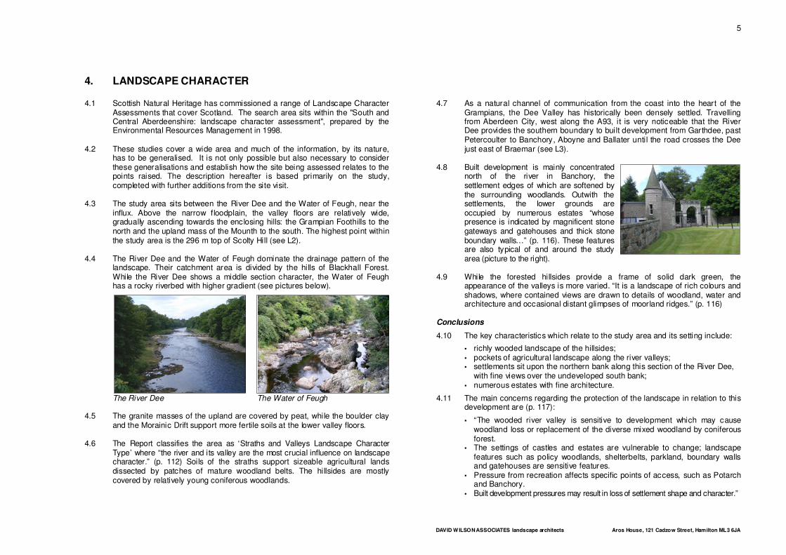
4.4 The River Dee and the Water of Feugh dominate the drainage pattern of the
landscape. Their catchment area is divided by the hills of Blackhall Forest. While the River Dee shows a middle section character, the Water of Feugh has a rocky riverbed with higher gradient (see pictures below).
The River Dee The Water of Feugh 4.5 The granite masses of the upland are covered by peat, while the boulder clay
and the Morainic Drift support more fertile soils at the lower valley floors. 4.6 The Report classifies the area as ‘Straths and Valleys Landscape Character
Type’ where “the river and its valley are the most crucial influence on landscape character.” (p. 112) Soils of the straths support sizeable agricultural lands dissected by patches of mature woodland belts. The hillsides are mostly covered by relatively young coniferous woodlands.
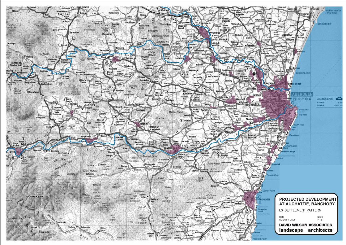
4.7 As a natural channel of communication from the coast into the heart of the Grampians, the Dee Valley has historically been densely settled. Travelling from Aberdeen City, west along the A93, it is very noticeable that the River Dee provides the southern boundary to built development from Garthdee, past Petercoulter to Banchory, Aboyne and Ballater until the road crosses the Dee just east of Braemar (see L3).
4.8 Built development is mainly concentrated
north of the river in Banchory, the settlement edges of which are softened by the surrounding woodlands. Outwith the settlements, the lower grounds are occupied by numerous estates “whose presence is indicated by magnificent stone gateways and gatehouses and thick stone boundary walls…” (p. 116). These features are also typical of and around the study area (picture to the right).
4.9 While the forested hillsides provide a frame of solid dark green, the
appearance of the valleys is more varied. “It is a landscape of rich colours and shadows, where contained views are drawn to details of woodland, water and architecture and occasional distant glimpses of moorland ridges.” (p. 116)
Conclusions
4.10 The key characteristics which relate to the study area and its setting include:
▪ richly wooded landscape of the hillsides; ▪ pockets of agricultural landscape along the river valleys; ▪ settlements sit upon the northern bank along this section of the River Dee,
with fine views over the undeveloped south bank; ▪ numerous estates with fine architecture.
4.11 The main concerns regarding the protection of the landscape in relation to this development are (p. 117):
▪ “The wooded river valley is sensitive to development which may cause woodland loss or replacement of the diverse mixed woodland by coniferous forest.
▪ The settings of castles and estates are vulnerable to change; landscape features such as policy woodlands, shelterbelts, parkland, boundary walls and gatehouses are sensitive features.
▪ Pressure from recreation affects specific points of access, such as Potarch and Banchory.
▪ Built development pressures may result in loss of settlement shape and character.”

DAVID WILSON ASSOCIATES landscape architects Aros House, 121 Cadzow Street, Hamilton ML3 6JA
6
DAVID WILSON ASSOCIATES landscape architects Aros House, 121 Cadzow Street, Hamilton ML3 6JA
7
DAVID WILSON ASSOCIATES landscape architects Aros House, 121 Cadzow Street, Hamilton ML3 6JA
8
5. DESCRIPTION OF THE SEARCH AREA
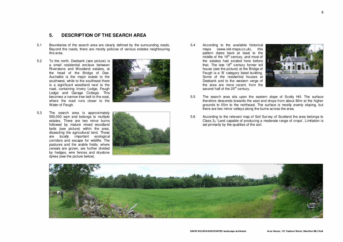
5.1 Boundaries of the search area are clearly defined by the surrounding roads. Beyond the roads, there are mostly policies of various estates neighbouring this area.
5.2 To the north, Deebank (see picture) is
a small residential enclave between Riverstone and Woodend estates, at the head of the Bridge of Dee. Auchattie is the major estate to the southwest, while to the southeast there is a significant woodland next to the road, containing Invery Lodge, Feugh Lodge and Garage Cottage. This becomes a narrow tree belt to the east, where the road runs closer to the Water of Feugh.
5.3 The search area is approximately
500,000 sqm and belongs to multiple estates. There are two minor burns followed by mature mixed woodland belts (see picture) within the area, dissecting the agricultural land. These are locally important ecological corridors and escape for wildlife. The pastures and the arable fields, where cereals are grown, are further divided by hedges, wire fences and drystone dykes (see the picture below).
5.4 According to the available historical maps (www.old-maps.co.uk), this pattern dates back at least to the middle of the 19th century, and most of the estates had existed here before that. The late 18th century former toll house (see the picture) at the Bridge of Feugh is a ‘B’ category listed building. Some of the residential houses at Deebank and to the western verge of the area are more recent, from the second half of the 20th century.
5.5 The search area sits upon the eastern slope of Scolty Hill. The surface
therefore descends towards the east and drops from about 80m at the higher grounds to 55m to the northeast. The surface is mostly evenly sloping, but there are two minor valleys along the burns across the area.
5.6 According to the relevant map of Soil Survey of Scotland the area belongs to
Class 32 ‘Land capable of producing a moderate range of crops’. Limitation is set primarily by the qualities of the soil.
DAVID WILSON ASSOCIATES landscape architects Aros House, 121 Cadzow Street, Hamilton ML3 6JA
9
6. PLANNING CONTEXT
6.1 In this chapter, the polices of the Approved Aberdeen & Aberdeenshire Structure Plan and The Aberdeenshire Local Plan, which have a relevance to this Landscape & Visual Impact Assessment are highlighted.
6.2 The search area sits outwith the urban envelope designated in the Local Plan,
and zoned as countryside. According to the housing policies new development will only be allowed on land allocated for housing. Since exceptional approvals do not seem to be relevant here, the development would only be possible in case of modification of the Local Plan.
6.3 If the development were to be considered, Local Plan Policies Gen1 and 2 are
important regarding landscape and visual impacts:
“Development will be assessed against sustainability indicators that relate to the local environment, community and economy, demonstrated by whether the proposal:
a) is concerned with the long term sustainable use and management of land; b) is well related to existing settlements and avoids dispersed patterns of development; … d) protects or enhances any valuable natural resources, including landscapes and wildlife habitats or species; e) does not damage built or cultural heritage resources; f) does not impact negatively on the character, including landscape character, environment or amenity of the surrounding area; … h) does not prejudice future development opportunities nor create a precedent for inappropriate future development patterns; …” (Policy Gen1, ‘Sustainability Principles’, p. 88)
“New development will be approved, in principle, if: a) it can be laid out to fit successfully into the site itself and respect the character and amenity of the surrounding area; b) its scale, massing, height and density are appropriate, whilst displaying a high standard of design, materials, textures and colours that are sensitive to the surrounding area; c) it respects existing natural and built features on or about the site which are worthy of retention; d) it respects the characteristics of the landscape in which it will be situated; … f) it respects important public views; … i) it conforms to Appendix 1.”
(Policy Gen2, ‘The Layout, Siting & Design of New Development’, p. 90) Appendix 1 mentioned above provides detailed requirements on the character of the development. These should also be taken into consideration.
6.4 Local Plan Policy Env1, ‘International Nature Conservation Sites’, requires that
development “likely to have a significant impact on a site designated or proposed under the habitats or birds directives (Special Area of Conservation and Special Protection Area) or on a Ramsar Site and not directly connected with or necessary to the conservation management of the site, must be the subject of an appropriate assessment for the implications for the site’s conservation objectives. …” (p. 10) It should be established therefore whether the projected development is likely to have significant impact on the nearby River Dee SAC.”
6.5 Similarly, according to Local Plan Policy Env5B, ‘Areas of Landscape
Significance’, development “within or adjacent to an Area of Landscape Significance will not be permitted where its scale, location or design will detract from the quality or character of the landscape, either in part or as a whole. … ” (p. 16) The assessment should therefore also establish how much the Area of Landscape Significance, containing the search area, will be affected.
6.6 Regarding present use of the area, Local Plan Policy Env11 ‘Agricultural Land’
is also important to mention: “Development that would cause the permanent loss of productive agricultural land will be refused unless it has been allocated for development in the Plan or the developer demonstrates: a) its social or economic benefit clearly outweighs the agricultural value of the site; AND b) there is no suitable alternative site for the development. Where the agricultural classification of the land is in question the developer must demonstrate its quality.” (p. 23)
Conclusions 6.7 As the site is designated as countryside, outwith the lands allocated for
housing, relevant policies of the extant local plan practically exclude the projected development.
6.8 More importantly, the search area is part of a designated Area of Landscape
Significance and is near to the River Dee SAC. The assessment should therefore establish whether and how these important areas would be affected.
DAVID WILSON ASSOCIATES landscape architects Aros House, 121 Cadzow Street, Hamilton ML3 6JA
10
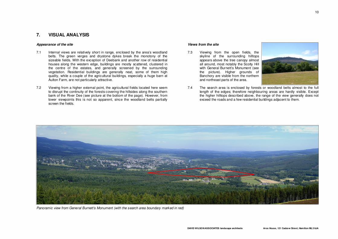
7. VISUAL ANALYSIS
Appearance of the site 7.1 Internal views are relatively short in range, enclosed by the area’s woodland
belts. The green verges and drystone dykes break the monotony of the sizeable fields. With the exception of Deebank and another row of residential houses along the western edge, buildings are mostly scattered, clustered in the centre of the estates, and generally screened by the surrounding vegetation. Residential buildings are generally neat, some of them high quality, while a couple of the agricultural buildings, especially a huge barn at Aulton Farm, are not particularly attractive.
7.2 Viewing from a higher external point, the agricultural fields located here seem
to disrupt the continuity of the forests covering the hillsides along the southern bank of the River Dee (see picture at the bottom of the page). However, from lower viewpoints this is not so apparent, since the woodland belts partially screen the fields.
Views from the site 7.3 Viewing from the open fields, the
skyline of the surrounding hilltops appears above the tree canopy almost all around, most notably the Scolty Hill with General Burnett’s Monument (see the picture). Higher grounds of Banchory are visible from the northern and northeast parts of the area.
7.4 The search area is enclosed by forests or woodland belts almost to the full
length of the edges; therefore neighbouring areas are hardly visible. Except the higher hilltops described above, the range of the view generally does not exceed the roads and a few residential buildings adjacent to them.
Panoramic view from General Burnett’s Monument (with the search area boundary marked in red)
DAVID WILSON ASSOCIATES landscape architects Aros House, 121 Cadzow Street, Hamilton ML3 6JA
11
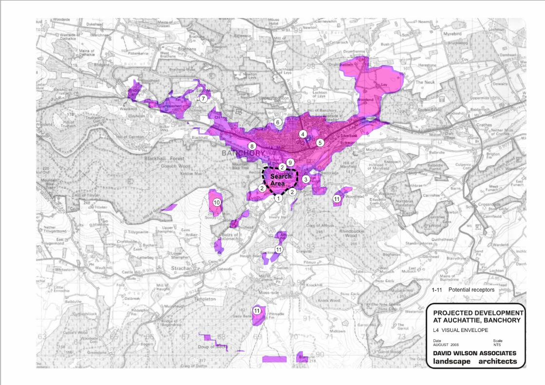
Visual receptors 7.5 The following is a study of the visual envelope that the developed site would
be anticipated to create (without mitigation). That is to say, the parcel of land from which the development would be seen if located anywhere within the search area.
7.6 This has been established through ground model analysis using KTF 6.7 software produced by Key TERRA-FIRMA Ltd and topographical Land-Form PROFILE data supplied by Ordnance Survey. The ‘Zones of Visual Influence’ output data (drawing no. L4) show the areas from which at least some part of the development could be seen based on the topography of the landscape with the larger areas of woodland superimposed as visual barriers at a generic height of 15m. The supposed height of development is taken to be 8m from ground level. It takes no account of physical visual barriers such as individual houses or buildings and smaller tree cover. These can be added to the analysis but are too numerous and varied to be included accurately. Within this envelope, there are areas, which will have a higher degree of visual sensitivity than others. Elements from which the site can be seen from are referred to in “Guidelines for Landscape and Visual Assessment” as visual receptors. These visual receptors have been looked at further, firstly by a desktop study, and then with a physical on-site analysis. At this point the impact of various physical barriers can be assessed.
7.7 Sitting on a hillside exposed to the north and northeast (towards Banchory), the
site has a visually relatively sensitive location. Views from the area described above, also determine the scope of potential visual receptors to consider.
1. Surrounding roads – Being directly adjacent to the site, and without knowing the exact character and form of the projected development, the roads marking the search area boundary have to be considered as sensitive receptors. Out of these the B974 is also a popular tourist road as the drive to the Bridge of Feugh and to the Cairn o’Mount.
2. Neighbouring residential buildings – For the same reasons described above, these also need further assessment.
3. Bridge of Feugh – As a popular tourism destination, this location is also important to mention. Nevertheless, the dense vegetation along the river provides sufficient screening in the long term.
4. Banchory – Sitting on a southern slope, most of the area of the settlement has a visual connection to the search area. Many residential houses have a view towards the area, while, due to the screening provided by the buildings and the vegetation, it can be hardly seen from public spaces.
5. A 93 road – The road is the main transport corridor along the River Dee Valley. The views towards the search area are mostly screened. There is a short open section at Banchory Ternan East Church. Views are possible
whilst walking, but not obvious when driving past. Other similar views are possible along this route.
6. Sunset Seat – The hilltop provides some pleasant walks for the residents of the nearby areas and a viewpoint to the south, from where the search area is possible to see.
7. Inchmarlo Golf Course – Sitting on a higher ground at the western outskirts of the settlement, the course is exposed to the search area, though the view is relatively distant and well screened.
8. Banchory Golf Course – The grounds of the golf course are at the lower terrace of the valley floor, thus the search area is almost completely screened by the woodland belts.
9. Banchory Lodge Caravan site – Although very close, the view is completely screened by the riverside woodland.
10. General Burnett’s Monument – As a listed building and a frequented tourism destination with a 360 degree panorama, the view tower and the surrounding hilltop is visually highly sensitive.
11. Surrounding hilltops – The area can be seen from several additional hilltops and ridges. However, these are covered by forest and mostly difficult to access.
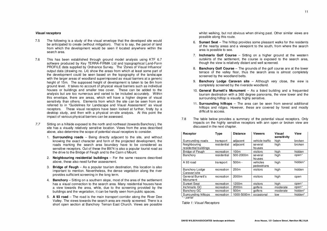
7.8 The table below provides a summary of the potential visual receptors. Only
impacts on the highly sensitive receptors with ann open or broken view are discussed in the next chapter.
Receptor Type Distance Viewers Visual sensitivity
View
Surrounding roads transport adjacent vehicle traffic high broken
Neighbouring residential bui ldings
residential adjacent several houses
high broken
Bridge of Feugh recreation 100m visitors high hidden Banchory residential 500-2000m several
houses high open*
A 93 road transport 500m - vehicles pedestrians
high hidden*
Banchory Lodge Caravan site
recreation 250m visitors high hidden
General Burnett’s Monument
recreation 2000m visitors high open
Sunset Seat recreation 1200m visitors high open*
Inchmarlo GC recreation 2000m golfers moderate open*
Banchory GC recreation 500m golfers moderate hidden*
Surrounding hi lltops recreation 1000-5000m occasional low hidden* * – partial
Table 1: Visual Receptors
DAVID WILSON ASSOCIATES landscape architects Aros House, 121 Cadzow Street, Hamilton ML3 6JA
12
DAVID WILSON ASSOCIATES landscape architects Aros House, 121 Cadzow Street, Hamilton ML3 6JA
13
8. LANDSCAPE AND VISUAL IMPACTS
8.1 The potential landscape and visual impacts that should be assessed in detail both during the construction period, as a result of its finished form and during its operation are established as follows:
▪ Loss of existing landscape features
▪ The visual impact of new elements on the sensitive receptors
▪ The overall change of landscape character anticipated, including possible generation of further development
Quality and loss of existing features 8.2 Topsoil and subsoil of the area will be significantly affected during the
construction works and landscaping. However, impact is less significant, since land capability for agriculture is moderate, and the soil can be stored and re-used in the course of landscaping.
8.3 Even although it has been disturbed by cultivation, the open agricultural land
provides an important contribution to the ecological corridors along and between the River Dee and the Water of Feugh. Any kind of development would inevitably affect this. Therefore, in case the development project progresses, an “appropriate assessment for the implications for the site’s conservation objectives” would be required as specified in the Local Plan Policy Env1.
8.4 The mature woodland belts along the two burns running across the area are
also locally important elements of the ecological network. Development would only be acceptable if these are neither broken nor reduced in extent.
8.5 Existing valuable buildings are not expected to be threatened. Other
structures, especially the drystone dykes, are also possible to preserve and integrate into the projected development.
Visual character of the new development 8.6 Although details of the projected development are not available, the projects
previously undertaken by the Prince’s Foundation for the Built Environment are recognised for their careful preparation and traditional architectural quality. The historical style characteristic of the Foundation’s developments could be in sympathy with the Victorian and Edwardian architectural heritage of the region.
Impact on the sensitive receptors 8.7 The impact on the surrounding roads and the neighbouring residential
buildings could be discussed together. Views from the roads and the buildings are relatively well screened. Retention of the important green verges and additional extension where necessary would mitigate any possible negative impact on these adjacent receptors.
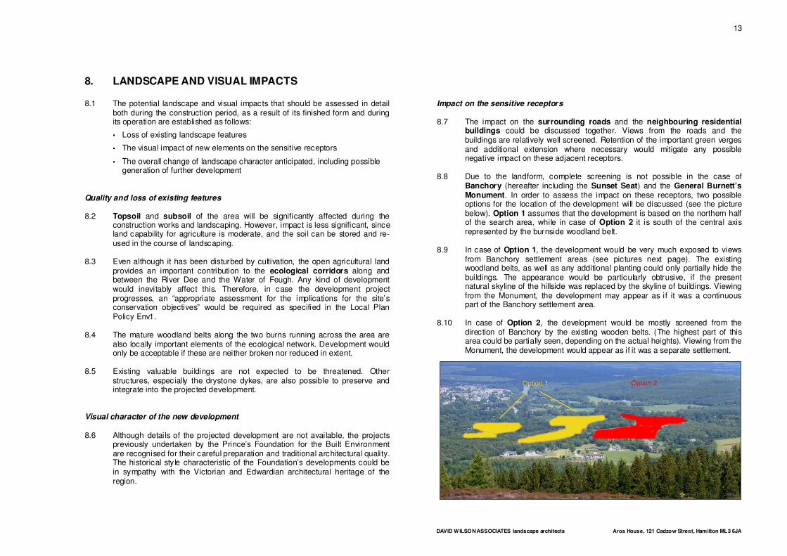
8.8 Due to the landform, complete screening is not possible in the case of
Banchory (hereafter including the Sunset Seat) and the General Burnett’s Monument. In order to assess the impact on these receptors, two possible options for the location of the development will be discussed (see the picture below). Option 1 assumes that the development is based on the northern half of the search area, while in case of Option 2 it is south of the central axis represented by the burnside woodland belt.
8.9 In case of Option 1, the development would be very much exposed to views
from Banchory settlement areas (see pictures next page). The existing woodland belts, as well as any additional planting could only partially hide the buildings. The appearance would be particularly obtrusive, if the present natural skyline of the hillside was replaced by the skyline of buildings. Viewing from the Monument, the development may appear as if it was a continuous part of the Banchory settlement area.
8.10 In case of Option 2, the development would be mostly screened from the
direction of Banchory by the existing wooden belts. (The highest part of this area could be partially seen, depending on the actual heights). Viewing from the Monument, the development would appear as if it was a separate settlement.
DAVID WILSON ASSOCIATES landscape architects Aros House, 121 Cadzow Street, Hamilton ML3 6JA
14
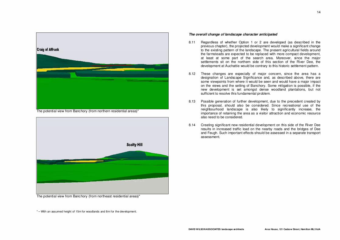
The potential view from Banchory (from northern residential areas)*
The potential view from Banchory (from northeast residential areas)* * – With an assumed height of 15m for woodlands and 8m for the development.
The overall change of landscape character anticipated 8.11 Regardless of whether Option 1 or 2 are developed (as described in the
previous chapter), the projected development would make a significant change to the existing pattern of the landscape. The present agricultural fields around the farmsteads are expected to be replaced with more compact development, at least at some part of the search area. Moreover, since the major settlements sit on the northern side of this section of the River Dee, the development at Auchattie would be contrary to this historic settlement pattern.
8.12 These changes are especially of major concern, since the area has a
designation of Landscape Significance and, as described above, there are some viewpoints from where it would be seen and would have a major impact on the views and the setting of Banchory. Some mitigation is possible, if the new development is set amongst dense woodland plantations, but not sufficient to resolve this fundamental problem.
8.13 Possible generation of further development, due to the precedent created by
this proposal, should also be considered. Since recreational use of the neighbourhood landscape is also likely to significantly increase, the importance of retaining the area as a visitor attraction and economic resource also need to be considered.
8.14 Creating significant new residential development on this side of the River Dee
results in increased traffic load on the nearby roads and the bridges of Dee and Feugh. Such important effects should be assessed in a separate transport assessment.
DAVID WILSON ASSOCIATES landscape architects Aros House, 121 Cadzow Street, Hamilton ML3 6JA
15
9. CONCLUSION
9.1 It is questionable whether any proposed development in this location will relate well to existing development, protect or enhance natural resources and also it will impact negatively on the landscape character, environment and amenity of the surrounding area.
9.2 Most of the existing valuable features could be preserved and integrated into
the projected development. However, potential impacts on the riverside ecological corridors and their link should be assessed according to the Local Plan Policy Env1.
9.3 The potential visual character of the buildings is expected to be in sympathy
with the traditional architectural style of the location. However, this factor alone does not justify a departure from policy.
9.4 The most significant visual receptors are the Banchory settlement area and
the General Burnett’s Monument. In their case, a complete mitigation is not possible due to the landform. From Banchory the view from many private houses, currently of open countryside, would be replaced with an extension of the town. This might be limited if development was kept to Option 2 but it would nevertheless have a significant impact. The view from the monument could become one of consistent development across the river, if it is located according to Option 1 (see above).
9.5 Although development could be undertaken in a sensitive manner, it would
have a significant effect on the setting of Banchory and how the town is perceived from both within and outwith the area. The most serious impact would be the development of the settlement southwards beyond the Dee. This would not only change the setting of Banchory but also affect its overall public image.
9.6 The present pattern of the landscape character would change by the
appearance of a new compact settlement unit on the southern bank of the River Dee, replacing the present agricultural fields. This departure from the historic pattern of development on Deeside is foreign to the area and indeed a significant departure from the principles normally advocated by the Prince’s Foundation. Though mitigation is possible, to a certain extent, this is the major concern, since the area has a designation of Landscape Significance.
9.7 Realisation of such a development would also set important precedent
implications for any future development of other Deeside communities such as Aboyne and Ballater.
DAVID WILSON ASSOCIATES landscape architects Aros House, 121 Cadzow Street, Hamilton ML3 6JA
16
REFERENCES
Plans and Research Studies
1. Guidelines for Landscape and Visual Impact Assessment (2002) The Landscape Institute and the Institute of Environmental Management and Assessment, London and New York
2. South and Central Aberdeenshire: landscape character assessment. Scottish National Heritage Review No 102 (1998) Environmental Resources Management, Edinburgh
3. North East Scotland Together. Approved Aberdeen & Aberdeenshire Structure Plan (2001–2016) Source: www.nest-uk.net
4. Aberdeenshire Local Plan (2006) Source: www.aberdeenshire.gov.uk/planning/finalised/index.asp
Maps
5. Landmark Information Group Limited’s Historical Map Archive website Source: www.old-maps.co.uk
6. Ordnance Survey, Explorer 406: Aberdeen & Banchory (2002)
7. Soil Survey of Scotland. Sheet 38: Aberdeen (1984) The Macaulay Institute for Soil Research, Aberdeen
Websites
8. Aberdeenshire Council website www.aberdeenshire.gov.uk
9. Scottish National and Regional Archaeological and Architectural Datasets www.pastmap.org.uk
10. Scottish Natural Heritage's Information service www.snh.org.uk/snhi
11. The Prince’s Foundation website www.princes-foundation.org
DAVID WILSON ASSOCIATES landscape architects Aros House, 121 Cadzow Street, Hamilton ML3 6JA
17
PRACTICE INFORMATION
David Wilson Associates
1. The landscape architectural practice of David Wilson Associates was
established in 1992 and now works from a busy design studio in Hamilton town centre. The staff consists of five qualified Landscape Architects including David Wilson, who has now over twenty five years professional experience. This is reinforced by two qualified and experienced garden designers and administrative back up.
2. The company use computer-based design and communication systems to
provide a professional landscape design and planning service to public agencies, commercial clients and private individuals throughout Scotland, Northern Ireland and the North of England.
3. The workload includes commercial housing layout design, industrial,
residential developments, road corridor improvement projects, community parks, play areas, private garden design and ecological and woodland habitat the full range of landscape initiatives.
4. In addition, the practice has provided a specialist service in preparation of
landscape and visual impact studies and, over recent years, has undertaken them for many developers including Bancon, Gladedale, Dawn, Manor Kingdom, Miller, Persimmon, Scotia, Stewart Milne and Wimpey Homes. This has often been followed by David Wilson acting as a professional expert witness at a subsequent public inquiry.