2. IWRM Thematic Paper 2.6/3: Conjunctive Use of ...
24
Integrated Water Resources Management Documents TP2.6/3 1. WRA China – UK, WRDMAP Integrated Water Resources Management Document Series 2. IWRM 3. Demand Manage- ment Thematic Paper 2.6/3: Conjunctive Use of Groundwater and Surface Water May 2010 4. Permitting 5. Economic Tools 6. Water Saving Society 7. Conflict Resolution 8. Inform- ation Exchange
Transcript of 2. IWRM Thematic Paper 2.6/3: Conjunctive Use of ...

Integrated Water Resources Management Documents TP2.6/3
1.
WR
A China – UK, WRDMAP
Integrated Water Resources Management Document Series
2.
IWR
M
3.
Dem
and
Man
age-
men
t
Thematic Paper 2.6/3: Conjunctive Use of Groundwater and Surface Water
May 2010
4.
Per
mitt
ing
5.
Eco
nom
ic
Tool
s
6.
Wat
er
Sav
ing
Soc
iety
7.
Con
flict
R
esol
utio
n
8.
Info
rm-
atio
n E
xcha
nge

Integrated Water Resources Management Documents TP2.6/3
Integrated Water Resources Management (IWRM)
(Basics after Global Water Partnership)
Enabling environment
• Allocation• Regulations• Economic Tools• ….
…..
Manag
ement in
strumen
tsInstitutional Roles
Ecological sustainability
Economic efficiency Social Equity
• Policies• Legislation• Fora and
mechanisms for participation
• International / inter-provincial co-operation
• …..….
• Level of action• Management
boundaries• Capacity building• …..
…..
Enabling environment
• Allocation• Regulations• Economic Tools• ….
…..
Manag
ement in
strumen
tsInstitutional Roles
Ecological sustainabilityEcological sustainability
Economic efficiencyEconomic efficiency Social EquitySocial Equity
• Policies• Legislation• Fora and
mechanisms for participation
• International / inter-provincial co-operation
• …..….
• Level of action• Management
boundaries• Capacity building• …..
…..
Driving Elements of Integrated Water Resources Management
Water ResourcesManagement
Resource Chargesand
Water Tariffs
Water Permits
Regulation and Control
Water UseNorms
WaterDemands
ResourceAssessments
Financial Resources
WaterResources
EnvironmentalConsiderat ions
SocialConsiderat ions
EconomicConsiderat ions
Inst itut ionalConsiderat ions
(Second figure after WRDMAP)

Integrated Water Resources Management Documents TP2.6/3
Page 1 of 20
Summary: This thematic paper describes the principles of conjunctive use of groundwater and surface water. It also highlights some of the misconceptions related to conjunctive use, which can result in unsustainable use of water resources.
The paper provides examples from international as well as from Chinese experience, and concepts are elaborated o using a variety of illustrations.
The Paper covers the following topics:
• Introduction
• Rationale for using conjunctive use
o Surface water schemes
o Groundwater schemes
o Conjunctive use schemes
• Managing conjunctive use schemes
o Establishment of scheme
o Overview of risk
o Policy and issues
• Both international and Chinese examples
This document is one of a series covering topics on sustainable water resources planning, allocation and management. Details are given in the bibliography.
The Ministry of Water Resources have supported the Water Resources Demand Management Assistance Project (WRDMAP) to develop this series to support WRD/WAB at provincial, municipal and county levels in their efforts to achieve sustainable water use.
1 Introduction Conjunctive use of water is the coordinated management of both surface water and groundwater for water supply.
The proceedings of a workshop led by the Food and Agricultural Organization of the United Nations (FAO), entitled ‘Land and water integration and river basin management,’ provide the following description on conjunctive use:
Conjunctive use of surface and groundwater consists of harmoniously combining the use of both sources of water in order to minimize the undesirable physical, environmental and economical effects of each solution and to optimize the water demand/supply balance.
The proceedings also say that: Usually conjunctive use of surface and groundwater is considered within a river basin management programme - i.e. both the river and the aquifer belong to the same basin.
This is an important statement. Failure to fully understand its meaning leads to misconception about water resource availability within a conjunctive use system.
The FAO workshop findings also highlight the challenges associated with conjunctive use of groundwater and surface water.
In summary these challenges include:
• The availability of aquifer storage and sufficient ability of the groundwater system to transmit and to release water
• The replenishment of the groundwater resource

Integrated Water Resources Management Documents TP2.6/3
Page 2 of 20
• A comparison of economic and environmental costs and benefits with alternative options for water use
This thematic paper describes the basic concepts of conjunctive use, its applications and advantages over alternative water resource use options, and the potential disadvantages and risks. The paper also attempts to address the misconceptions that are known to exist in many parts of the world.
Conjunctive use needs to be considered from the river basin perspective, but can also be applied to local situations where one can have, for example, an area of land that can be irrigated from either surface water or groundwater resources.
In the context of this paper, the groundwater component of a conjunctive use scheme is assumed to have a good enough water quality for use in water supply and/or irrigation. Thus there is no discussion on situations where surface water is used for irrigation and groundwater extracted for drainage purposes and exported via a surface drainage network.
The Agricultural & Rural Development Notes, Issue 6 entitled “Conjunctive Use of Groundwater and Surface Water, February 2006” provides valuable reading on conjunctive use. Material from this reference is used within this paper.
Box 1 Benefits of Conjunctive Management in Madhya Ganga Canal project, Uttar Pradesh, India River diversion systems often use lined canals to remove excess floodwaters during the monsoon. However, simple modifications in infrastructure and operating system can transform this waste into wealth. Uttar Pradesh had a network of disused earthen surface drains constructed in the 1950s to control water logging and floods. After the 1950s, intensification of groundwater use created new opportunities for conjunctive management by building check structures at suitable intervals to promote groundwater recharge with monsoon floodwaters. In the course of a 10-year collaborative study, scientists from the International Water Management Institute (IWMI), Roorkee University, the Water and Land Management Institute, and the Uttar Pradesh Irrigation Department found that using these modified drains for monsoon flood irrigation produced the following benefits:
• A 26 percent increase in net farmer income
• A decrease in average depth of groundwater from 12 metres in 1988 to 6.5 metres in 1998
• Annual energy savings of 75.6 million kilowatt hours and pumping cost savings of Rs. 180 million
• An increase in canal irrigation from 1.251 hectares in 1988 to 37,108 hectares in 1998
• A 15-fold increase in rice area
• A 50 percent reduction in conveyance losses in canals
Source: IWMI 2002

Integrated Water Resources Management Documents TP2.6/3
Page 3 of 20
Box 2 Conjunctive Use with Poor Quality Water: Irrigation with Mine Water in South Africa
River Disposal of mine water is a problem wherever there are coal and gold mines, as in South Africa. High concentrations of salt make the wastewater unsuitable for direct discharge into rivers except in periods of high rainfall. The potential for irrigating with mine water in suitable soils is increasingly viewed favourable as a way of solving the twin problems of wastewater disposal and shortage of irrigation water. How big the opportunity is depends on the availability of suitable soils nearby, the resultant soil water and salt balance for different cropping systems, the choice of irrigation management strategies, and the impact of the irrigation drainage on local and regional water resources. The approach is inherently conjunctive, because polluted mine water is used to complement inputs from rainfall and stream flows. In a field trial in South Africa during 1997-2000, three center pivots were set up for irrigation with coal mine wastewater – one in virgin soil (unmined) and two in mine-rehabilitated land. Several crops were successfully irrigated with gypsiferous mine water on a commercial scale. Excellent yields were obtained for wheat on both virgin and rehabilitated land, and also short-season maize grown on virgin land. The yields of sugar beans were reasonable and higher than with dry land cropping. Problems that caused yield reductions were not related to irrigation with gypsiferous mine water and were recognized as surmountable with experience in the management of the systems. Research is continuing, using catchment-scale computer modelling to assess the impact of scaling-up on the volume and quality of surface water and groundwater. Source: Olufemi Idowu and Simon Lorentz, University of Kwa Zulu Natal, with inputs from IWMI, Africa
2 Rationale for Using Conjunctive Use Schemes
2.1 Introduction
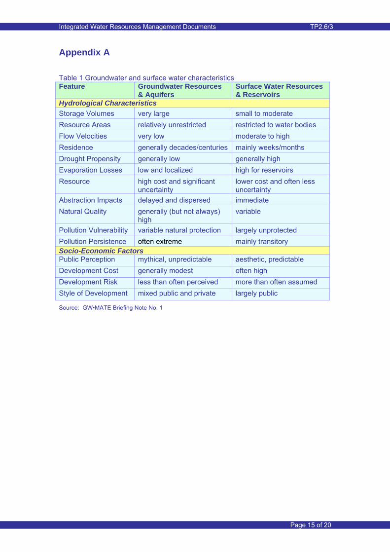
The hydrological characteristics and socio-economic implications of ground-water and surface water supply are certainly varied. Table 1 in Appendix A highlights the distinct differences in the characteristics of groundwater and surface water reservoirs. It has been reproduced from GW•MATE Briefing Note 1: Groundwater Resource Management.
2.2 Surface water schemes
Surface water as a source for urban/industrial and, more importantly, for irrigation use suffers from inherent mismatches between supply and demand, and also the mismatch between competing uses of the water. A number of international examples shown below illustrate these mismatches.
Example 1: Bangladesh
In Bangladesh the climate exhibits a very wet monsoon season from June through to September and an extended dry period from October to May. Traditionally extensive cropping would occur during the monsoon season without the need for irrigation water. During the dry season limited surface water was available, only for localised irrigation. Insufficient rainfall could not secure the success of a rain fed crop, except in areas where soil conditions were favourable to release sufficient soil moisture stored during the monsoon season.
The past 20 years has seen a vast expansion in irrigated agriculture during

Integrated Water Resources Management Documents TP2.6/3
Page 4 of 20
the dry season using groundwater. It can be considered as one of the largest conjunctive use scheme in the world and has contributed significantly to food self-sufficiency.
Example 2: Central Asia
River water is extensively used for both irrigation and for power generation. Large surface water reservoirs have been built for water storage and controlled releases. There is a clear demand conflict, with releases required for power generation during the cold winter period and release for irrigation during the summer period.
The example illustrates the potential conflicts between water users and points to the need for strong integrated water resources management.
Matching the surface water availability with water demands is difficult when large scale retention and storage facilities (reservoirs) are not available. And even if reservoirs were available, hydropower demands can dominate. The risks of not matching demand with supply can thus be high, while surplus resource can easily be lost to unproductive downstream areas.
One of the major challenges of surface water only systems that are used for irrigation is the control of rising groundwater levels and subsequent water logging and salinity problems. Water logging and salinity problems are very common in semi-arid and arid regions throughout the world. These situations inevitably need drainage systems installed; either surface, sub-surface or groundwater (well drainage), or a combination of those. Use of resulting drainage water should always be considered and ecological impacts are important and need to be considered. Examples given below are
just a snapshot of the widespread problem.
Example 3: United Kingdom
European legislation emphasises the water needs of the environment. Where river water is used for drinking water supply, the requirements of minimum river flows pose significant challenges to water companies to satisfy demand during drought periods. This challenge is exacerbated by the restrictions on groundwater availability during such droughts.
The need to balance human and environmental water needs is becoming ever more important and requires commitment from all involved with water supply, water use and the environmental wellbeing.
Example 4: Egypt
Expansion of surface water irrigation into desert areas fringing the Nile Valley and the Nile Delta has resulted in rapid rise in groundwater levels. In the West Nubaria area, located to the south west of Alexandria, groundwater levels rose by about 2 to 3 m per year in the 1970’s when irrigation expansion started. The rapid rise was attributed to lack of natural groundwater drainage and the use of inefficient irrigation techniques on permeable soil. Groundwater levels rapidly rose to close to ground surface and caused significant water logging and salinity problems. The latter was exacerbated by the high salinity of the resident groundwater.
The problem has eventually been resolved by installation of drainage systems. Not dealing with the drainage problem in advance has led to high cost rehabilitation of the irrigation system.

Integrated Water Resources Management Documents TP2.6/3
Page 5 of 20
Example 5: Kazakhstan
Irrigation using surface water in the Karshi steppes caused rapid groundwater level rise and subsequent water logging and salinity problems. The irrigated area was large and despite the good water transmitting properties of the underlying aquifer, natural drainage could not cope with the influx of recharge from irrigation application. This example illustrates that surface water irrigation, particularly when this is inefficient, will lead to problems even when aquifer conditions appear to be favourable.
2.3 Groundwater schemes
Using only groundwater can be an alternative to using surface water. Groundwater is extensively used when productive aquifers are present and when sufficient natural recharge is available to replenish the quantities of groundwater abstracted for different uses.
In arid and semi-arid areas, natural recharge is limited and the use of groundwater can easily lead to over-use and consequently to groundwater level decline and deterioration of groundwater quality. An unsustainable water resource situation results as a consequence.
The following examples of groundwater use illustrate the opportunities and challenges.
Example 6: United Kingdom
Major aquifers in England support large scale groundwater abstraction for public water supply and, to a lesser extent, for irrigation and industrial use. European legislation has placed emphasis on water requirements for the environment. This includes satisfying in-river flow requirements and maintaining high groundwater table conditions in groundwater dependent ecosystems (GWDTE), even during drought periods. The environmental needs thus place a constraint on the allowable quantity of groundwater that can be abstracted.
Restrictions also apply to coastal and inland areas where there is a threat of saline intrusion and thus contamination of water supply sources.
Example 7: China
Over the past 40 years or so, over-use of groundwater for irrigation in the Minqin oasis of the Shiyang River Basin has led to significant decline in groundwater levels (more than 30m in places) and a gradual deterioration of groundwater quality due to increased salinity. Such a situation, which has resulted from a large imbalance between groundwater abstraction and recharge, is unsustainable and has major impacts on human livelihoods and leads to environmental degradation.
2.4 Conjunctive use schemes
Conjunctive use of groundwater and surface water can overcome some of the challenges described for surface water and groundwater schemes. Significant challenges remain and these are discussed in Section 3.
There are a number of different reasons for adopting conjunctive use of groundwater and surface water as listed

Integrated Water Resources Management Documents TP2.6/3
Page 6 of 20
below. Sometimes such reasons can be combined so that the scheme reaps multiple benefits.
Control of high groundwater table situations
Shallow groundwater conditions develop in areas irrigated with surface water and where natural drainage is insufficient to keep groundwater levels at sufficient depth below ground surface. Shallow groundwater table conditions are the cause of water logging and salinity in the root zone of crops and can render irrigated areas unsuitable for further cultivation. Evaporation from the soil surface comprises a significant non-beneficial loss to the total water resource in high groundwater table situations. An example is shown in Appendix B1.
Examples of water logging and salinity problems are available from many parts of the world and even go back to historical times. In the past, planners of large scale surface water irrigation schemes have generally given insufficient attention to the longer-term need for drainage to avoid shallow groundwater table conditions. Groundwater levels may have been deep originally and insufficient groundwater assessment/ monitoring was undertaken to recognise the problem. Groundwater abstraction can be used for groundwater level control. If groundwater is of poor quality, then drainage canal systems need to be in place to export water from the area. Such a system is, for example, in place on the left bank of the River Indus in Pakistan, where the groundwater system conditions favour the use of vertical drainage. If the groundwater is of good quality, it can be used in combination with surface water for irrigation and possible other uses. Examples of this type of conjunctive use
can be found in the Tarim Basin in Xinjiang Autonomous Region and in the Nile Valley in Egypt.
Control of declining groundwater levels
A second reason for using conjunctive use of groundwater and surface water is the control of declining groundwater levels in areas where groundwater abstraction has historically exceeded groundwater recharge. This situation is very common in many parts of Northern China. The use of surface water needs to be sufficient to ensure that recharge to the aquifer at least balances the net groundwater discharge.
Aquifer Storage and Recovery Schemes - ASR
Aquifer Storage and Recovery (ASR) is a method of enhancing water recharge to aquifers by gravity feeding or pumping excess surface water into the aquifers for later use in times of peak demand. Where the aquifers are suitable it offers a comparatively low cost method of storing water as an alternative to surface storage.
Three methods are commonly used for ASR:
1. Injection and recovery wells, which is the most difficult and expensive method of ASR because if the source water is not adequately treated, clogging can quickly render the well(s) inoperable.
2. Infiltration basins, in which water (which could include treated sewage effluent and storm water runoff) is collected and allowed to infiltrate through the base of the ponds into the underlying aquifer
3. Bank filtration, whereby abstraction wells adjacent to a

Integrated Water Resources Management Documents TP2.6/3
Page 7 of 20
river are used to encourage water movement to the groundwater store via the bed and banks of the river. This method can be used even for ephemeral rivers. Recharge would in this case occur during the flood season.
Figure 1 Methods for ASR
Artificial recharge using injection wells
Artificial recharge using infiltration basins
Artificial recharge using bank infiltration
However, a key factor is often the impact on river base flows and the ecological consequences.
Bank infiltration can be enhanced by retaining surface water and building of the surface water level. In Chaoyang in Liaoning province, rubber dams are used for retention of surface water, which is allowed to infiltrate and flow towards river bank abstraction wells.
The key constraints on the development of ASR using injection and recovery wells, which have been identified by research in the United Kingdom, include:
• Recovery efficiency, a measure of how much water can be recovered against how much is put in. Low efficiency is less significant where both recharged and native waters are potable and of similar quality
• Clogging issues, including air entrainment, suspended sediment, bacterial growth, chemical reactions, gas production and compaction of clogging layer
• Water quality changes, chemical components of the recharged water reacting with groundwater and aquifer, particularly the organochlorine compounds in the treated recharge water
• Hydraulic properties of aquifers
• Operational issues, including variability in volume and quality of water available for recharge but less significant when treated effluent is used, variation in daily and weekly demand in relation to average monthly or annual demand and site selection
• Regulatory issues

Integrated Water Resources Management Documents TP2.6/3
Page 8 of 20
Box 3 below provides an example of a large and established ASR scheme in London (United Kingdom), operated and managed by Thames Water.
Box 3: ASR - The North London Artificial Recharge Scheme
The North London Artificial Recharge Scheme (NLARS) was established during the 1990’s. Thames Water Utilities Ltd operates two artificial recharge schemes in North London. These are designed to exploit storage in the underlying, partially dewatered, aquifer system and are based upon dual purpose abstraction/recharge wells. Surplus surface water is treated to drinking water standard and then injected into the aquifer. Abstraction and release from storage takes place during drought periods when surface supply is inadequate.
NLARS is one of the largest artificial recharge schemes in the world and advantage has been made of available aquifer storage developed during extensive groundwater for industrial used during the first half of the 20th century.
Around 100,000 m3/d can be abstracted, enough to supply 500,000 people. That figure could double as more of the 41 boreholes come on line.
Source: Thames Water
Recharge dams could also be considered as being an ASR scheme. Recharge dams are used for temporary storage of flash floods and gradual release in subsequent days. Releases are allowed to recharge the
groundwater downstream of the dam and avoid surface water losses during significant floods. Such dams have been constructed in the Batinah coastal plain in Oman. Wadi flows are retained for up to a few weeks to avoid losses of

Integrated Water Resources Management Documents TP2.6/3
Page 9 of 20
flash floods to the sea. Such configurations can either be in-stream or off-stream storage.
Check dams such as the rubber dams used in Chaoyang in Liaoning Province are used to raise the river water level behind the dam. The established lake behind the dams serves to enhance river bank infiltration and also has an amenity value.
Optimisation of water use
Examples 6 (UK) and 7 (China) above shown above stem from the need to alleviate or rectify problems. Optimisation of water use through conjunctive use of groundwater and surface water should be seen as the main aim of conjunctive use schemes. Such optimisation will have ‘problem solution’ as an inherent component of the scheme.
The aquifer system should be considered as a reservoir in which water can be stored and from which water can be extracted, this depending on availability of surface water for intended uses. Since aquifers are often of regional extent, their storage capacity can be very significant. Box 4 illustrates an example for putting the groundwater reservoir size into context.
The example in Box 4 shows that groundwater can serve a very important role in reducing risk associated with surface water availability constraints during droughts. Conjunctive schemes can also overcome the timing constraints related to supply and demand, particularly when there is limited scope for surface water storage. For example surface water supply may be high in winter/spring, but low in summer. In such a situation surface water could be used to replenish the groundwater reservoir in winter, and groundwater used for irrigation during
the irrigation demand period in the summer.
Box 4 Groundwater reservoir storage - Minqin oasis, Gansu County, Shiyang River Basin
The approximate area where groundwater is and can be abstracted is ~ 500 km2 (~ 750,000 mu). The aquifer has good storage properties and a storage coefficient of about 10% has been used in recent modelling studies. This implies that, over the aforementioned area, a one metre drop in groundwater level would yield 50 million m3 of groundwater. In reality the contribution area would be larger and thus more water could be released. Given the future planned allocation of surface water to the Minqin oasis of about 300 million m3/year, such potential release from groundwater is very significant. It indicates that the groundwater reservoir capacity is very large and dwarfs the Hongyashan surface water reservoir, which has a live storage of 54 million m3.
Optimisation schemes can also be used at a more local scale. The example shown in Appendix B2 illustrates the use of river water to replenish groundwater extracted for local drinking water supply.
Total resource availability needs to be known and also the variability in the availability of surface water, both over medium time periods with respect to natural variability, and in terms of the longer term with respect to the possible impacts of climate change. Conjunctive use schemes of this type help buffer the effects of surface water drought and/or reduced natural recharge because groundwater abstraction can be increased during such drought years. During years of surplus surface water and/or enhanced natural recharge, groundwater use can be decreased and the groundwater resource be allowed to replenish through enhanced recharge.
Integrated Water Resources Management Documents TP2.6/3
Page 10 of 20
Concepts such as intra- and inter-annual regulation are sometimes referred to in the literature. The first relates to overcoming the problems with lack of surface water availability during the crop season. Inter-annual regulation covers a number of years. In this case one would use more groundwater during years when surface water supply is below average, while less groundwater would be used during periods of above average surface water availability. For the latter period the groundwater reservoir is replenished. Appendix B3 illustrates intra- and inter-annual regulation concepts.
It is important that clear guidance is available on the limits imposed on the minimum and maximum allowable (or possibly desirable) groundwater levels. Such guidance should be combined with strategic monitoring of groundwater levels and several locations within the conjunctive use area.
3 Establishment and Management of Conjunctive Use Schemes
3.1 Establishment of the scheme
It is not uncommon that both surface water and groundwater are used to satisfy water demands. However, the sources are often considered in isolation and not as a combined (integrated) source. The establishment of conjunctive use schemes requires consideration of the following aspects, which are of both a technical and non-technical nature:
• There is need for adopting the concept of a single and fully integrated resource. It is not unusual for water resources
planners (possible due to pressure from politicians) to double count resource availability. An example of this is presented in Box 5 below. There are resource gains to be made and these relate to reduction in non-beneficial losses from the groundwater system. This is illustrated in Appendix B1.
• It is thus imperative that clarity is provided on what a conjunctive scheme entails and that misconceptions about resource availability are avoided.
• There needs to be a sound understanding of the integrated groundwater and surface water system and its responses to natural and anthropogenic influences. Such understanding needs to be established for conditions that prevailed historically and those that are planned for the future. The use of appropriate resource assessment methodologies and the use of simulation models (integrated surface water and groundwater models) allow for enhancement of understanding and quantification of resource responses to the above mentioned influences. Reference is made to Thematic Paper 1.1 ‘Groundwater Flow Modelling’, and Thematic Paper 1.2 ‘Groundwater Resource Quantity Assessment’.
• Effective and focused monitoring of surface water and groundwater behaviour as a consequence of known influences such as climate and groundwater use (which also need to be monitored) is indispensable for establishing understanding of the integrated system. The concepts and requirements for comprehensive monitoring of an integrated surface water and groundwater system are described in Thematic Paper 2.6/2

Integrated Water Resources Management Documents TP2.6/3
Page 11 of 20
‘Groundwater Monitoring and its Importance to IWRM’.
• One of the biggest issues of conjunctive use systems is that of spatial coincidence of the resource and the existence of a transfer or distribution system that facilitates/enables the use of either resource to meet a particular demand.
• The groundwater reservoir needs to be capable of being rapidly recharge and have hydrogeological characteristics that enable easy extraction of groundwater at affordable cost.
• Understanding is required of the capacity of the groundwater system to receive water (through recharge), convey water (lateral groundwater movement) and release water (for example through groundwater abstraction from wells). There is also a need to understand the efficiency of the groundwater reservoir. The efficiency may be defined as the ratio of possible net groundwater use and the total replenishment from precipitation, net groundwater inflow (if relevant) and return flow from surface water irrigation. This ratio is less than or equal to 1 and depends on how much sub-surface outflow from the groundwater reservoir occurs. This ratio would not be fixed, but would likely be dependent on the level of storage within the groundwater reservoir. Integrated groundwater and surface water models are ideal tools to determine the efficiency of a groundwater reservoir from the dynamic analysis of the groundwater balance. An illustration of the concept of groundwater reservoir efficiency is given in Appendix B4.
Box 5 Double counting of resources in Egypt
The long term average release from the Aswan High Dam in Egypt is about 50 billion m3/year. This volume of water is used to satisfy all water demands in the Nile Valley and Nile Delta. A major part of this water is used for irrigation.
Rapid population increase in the 1970’s called for increase in food production and thus for expansion of agricultural areas. This required additional water resources and there was political pressure to find those. The Nile Valley is underlain by highly productive aquifers and its potential for using this groundwater was considered. Incorrectly, it was considered as an additional resource. The intention was to use this groundwater and use ‘saved’ surface water for irrigation expansion. However, this was a false premise, because the groundwater originates from surface water used for irrigation. Groundwater abstracted from the Nile Valley aquifer would thus have to be replenished from surface water to avoid continued groundwater level decline and therefore no resource gains are achieved.
The above situation applies to areas where surface water irrigated areas and the associated groundwater reservoir coincide.
• Clear rules on water use practices and water use priorities need to be prepared and such rules need to be enforced. For example the use of groundwater may be preferred by farmers for reasons of cost or reliability of supply. The risk is that surface water, although available, would not be used, and this would compromise the replenishment of the groundwater reservoir. Equally, in an urban setting, groundwater may be preferred for water quality reasons, because this would limit the cost of treatment.
• There is thus a need for the preparation and implementation of comprehensive water allocation

Integrated Water Resources Management Documents TP2.6/3
Page 12 of 20
and use plans. Comprehensive implies that special plans, such as for example those related to drought, are sub-components of the comprehensive plan. The planning would need to be flexible and adaptable because of the uncertainties inherent in forecasting the availability of surface water. Longer-term water allocation is normally derived from statistical analysis of historical water availability, particularly surface water. On a shorter term basis the actual surface water availability would need to be taken into account and this would determine the amount of groundwater that can be taken. It should be noted that groundwater resource availability is primarily limited by recharge.
• The natural variability in surface water availability is thus compensated for by the use of variable quantities of groundwater, with the total being constrained by the average annual quantity set out in the comprehensive plan. It is important to realise the significance of using more surface water (and thus enhancing recharge) during periods of surface water surplus so that depleted groundwater reserves can be replenished.
• It should be appreciated that comprehensive plans may have been based on limited data/understanding of the behaviour of the integrated surface water and groundwater system. Lack of data and understanding results in uncertainty and it should be a clear aim of the comprehensive plan to address such uncertainty and reduce it over time. This requires continuous monitoring of all aspects of
resource behaviour, water allocation and actual use. Reference is again made to the aforementioned thematic paper on monitoring.
• It is essential that an integrated approach is also used in the management of the water allocation plans and in the overall management of water resources, including planning, assessment, monitoring, etc. This requires strong institutions where compartmentalisation into separate surface water and groundwater sections is avoided.
• Comprehensive planning requires good communication, participation and knowledge management strategies. Communication and participation strategies are required, which set out in detail the requirements and procedures for communication and participation, both within the planning organisation and between the organisation and stakeholders. Knowledge management is required to ensure the successful implementation and maintenance of the conjunctive use scheme. It involves the process of data management and the sharing of data/information within the organisation and with stakeholders.
• There is thus a need for building technical capacity, for adapting the organisational and institutional setup, and improving information and communication systems
Integrated Water Resources Management Documents TP2.6/3
Page 13 of 20
3.2 Overview of risks
Risks to the success of conjunctive use schemes are summarised and, if relevant, illustrated with examples of international and national practice. Suggestions on overcoming and/or reducing risk are also included.
Double counting
The double counting was already referred to before and illustrated in Appendix B2. It is all too tempting to double count, particularly when there is political pressure to enhance agricultural production through utilisation of ‘new’ water resources. Double counting can also result from insufficient understanding of integrated water resource behaviour and/or lack of communication between compartmentalised departments (dealing separately with surface water and groundwater issues) within a river basin organisation, or even different organisations or different departments within ministries.
Uncertainty in estimates of total resource availability
If estimates of resource availability are too high, then the risk of unsustainable development and possible over-investment will result. Such risk arises when uncertainty underlies the assessment of available surface water and groundwater resources and is ignored by the organisation responsible for the conjunctive use scheme. When uncertainty is recognised, then a phased development would be prudent. A sufficient safety margin should thus be adopted in the initial development of the scheme, while at the same time appropriate monitoring systems are put into place so that new data can be used to reduce uncertainty. This approach is
referred to in the literature as ‘adaptive’ management.
Resource degradation
The benefits resulting from implementation of conjunctive use schemes are often reasonably well recognised. Assessing the consequences of conjunctive use schemes on the longer-term changes in groundwater quality is more difficult, yet requires appropriate attention. The salinity issue is often ignored because of its slow change over time, but may eventually become a serious problem. Assessing groundwater and soil salinity and its changes over time, requires both effective monitoring and the use of salt balance models. Integrated groundwater flow and water quality models could also be considered for addressing the longer term salinity changes.
Environmental degradation
The use of groundwater can result in groundwater level decline, which can have a negative impact on established wetlands or groundwater dependent terrestrial ecosystems (GWDTE). Equally, lowering of the groundwater level could impact on the base flow to rivers, which could compromise the ecological status of the river. Groundwater level lowering can also cause intrusion of saline groundwater, particularly in coastal areas.
It is important that the risks of falling groundwater levels on the eco-environment are addressed. Ecological standards need to be set so that minimum allowable groundwater level conditions can be set. It is particularly important to take account of the impact of drought periods. Minimum allowable groundwater levels depend on soil and sub-soil characteristics and on vegetation type. For example a silty

Integrated Water Resources Management Documents TP2.6/3
Page 14 of 20
soil/sub-soil would allow for a deeper groundwater table than a sandy soil. Trees root deeper than other vegetation and would therefore also be able to tolerate a deeper groundwater table.
It is possible to consider mitigation measures to alleviate the negative impact of groundwater level lowering. For example some groundwater could be used for augmentation of river flows or for provision of water to wetlands, particularly during drought periods. In the United Kingdom, river augmentation schemes were developed and implemented during the prolonged droughts of the early 1990’s. An illustration of one of those schemes is presented in Appendix B5.
3.3 Policy and institutional issues
The following has largely been based on the reference given in Section 1.
• Conjunctive use requires a river basin level perspective and therefore effective river basin scale organisations.
• The water resources management institutions must move away from their fragmented structure, which inhibits communication and the coordinated approach to water management required for successful implementation and management of conjunctive use schemes.
• Improved monitoring systems, data management and information dissemination strategies need to be in place to ensure successful conjunctive use schemes. GIS and associated database systems are valuable aids in enhancing understanding of system behaviour and therefore contribute to effectiveness and efficiency.
• Where both public and private groundwater development occurs, opportunities arise for mutually gainful public-private partnerships with better coordination and an appropriate policy framework. In the China context a partnership between WUAs and the management bureaux would reap significant benefits.
• There may be a need for rehabilitation of surface water distribution systems and change in operation schedules. (Refer back to Box 1 for an example of the role surface water can play in enhancing groundwater availability.)
Integrated Water Resources Management Documents TP2.6/3
Page 15 of 20
Appendix A
Table 1 Groundwater and surface water characteristics Feature Groundwater Resources
& Aquifers Surface Water Resources & Reservoirs
Hydrological Characteristics Storage Volumes very large small to moderate Resource Areas relatively unrestricted restricted to water bodies Flow Velocities very low moderate to high Residence generally decades/centuries mainly weeks/months Drought Propensity generally low generally high Evaporation Losses low and localized high for reservoirs Resource high cost and significant
uncertainty lower cost and often less uncertainty
Abstraction Impacts delayed and dispersed immediate Natural Quality generally (but not always)
high variable
Pollution Vulnerability variable natural protection largely unprotected Pollution Persistence often extreme mainly transitory Socio-Economic Factors Public Perception mythical, unpredictable aesthetic, predictable Development Cost generally modest often high Development Risk less than often perceived more than often assumed Style of Development mixed public and private largely public
Source: GW•MATE Briefing Note No. 1

Integrated Water Resources Management Documents TP2.6/3
Page 16 of 20
Appendix B1
Water saving with conjunctive use of surface water and groundwater Shallow groundwater table situation with surface water irrigation only
Deep groundwater table with conjunctive use of surface water and groundwater
Assumptions: • The conclusions drawn from the analysis is based on a hypothetical situation that is
representative for irrigated arid areas in the northern hemisphere • No rainfall • No lateral groundwater inflow and outflow
High Groundwater Table
SW = 846 mm/year
ETc = 592 mm/year
NBE = 846 – 592 = 254 mm/year
The total net resource required is equal to the gross resource supplied by surface water (SW) 846 mm. The total crop consumptive use (Etc) is 592 mm, while non-beneficial evaporation (NBE) from the soil surface is 254 mm. The derived value assumes an application efficiency of 0.7.
Evaporation from the soil surface occurs during periods when a bare soil surface occurs (outside the crop season) and during the early and late stages of crop development. The evaporation is balanced by upward capillary flow from the shallow groundwater table, which is maintained by recharge from irrigation application.
Low Groundwater Table
SW = 592 mm/year
ETc = 592 mm/year
GW = 254 mm/year
The gross allocation of surface water is 592 mm of which 178 mm (70% of 254) will recharge to groundwater.
The gross groundwater abstraction (GW) is 254 mm of which 76 mm returns to groundwater (assuming the same irrigation efficiency of 0.7). Thus the net abstraction is 178 mm.
Because the groundwater table is deep, there is no capillary upward flow and thus no evaporation from the land surface.
The total net resource is now 592 mm and the saving equates to the non-beneficial loss for the shallow groundwater table (254 mm).
SW ETc
NBE SWETc
GW
Water table
Water table

Integrated Water Resources Management Documents TP2.6/3
Page 17 of 20
Appendix B2
Small scale groundwater storage schemes
Without abstraction, recharge through the river bed occurs until the aquifer is refilled and further infiltration becomes limited. With abstraction, extra storage is created during the dry season, when the river is dry. During river floods, infiltration is for a longer period until the groundwater reservoir is refilled. Abstracted water can be used for irrigation or directed to surface storage elsewhere. Such systems are often of small scale and secure water supply, either for village water supply (for example in Botswana) or for small scale irrigated agriculture (for example in northeast Brazil). Careful management and monitoring is required to secure the groundwater supply during drought periods.
Groundwater level at end of dry season (no abstraction)
Groundwater level at end of dry season (with abstraction)
Additional groundwater storage
Groundwater level at end of flood season (with abstraction)
Wells
Ephemeral river
Integrated Water Resources Management Documents TP2.6/3
Page 18 of 20
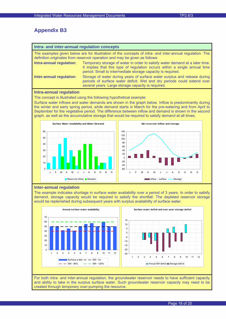
Appendix B3
Intra- and inter-annual regulation concepts The examples given below are for illustration of the concepts of intra- and inter-annual regulation. The definition originates from reservoir operation and may be given as follows: Intra-annual regulation: Temporary storage of water in order to satisfy water demand at a later time.
It implies that this type of regulation occurs within a single annual time period. Small to intermediate storage capacity is required.
Inter-annual regulation: Storage of water during years of surface water surplus and release during periods of surface water deficit. Wet and dry periods could extend over several years. Large storage capacity is required.
Intra-annual regulation The concept is illustrated using the following hypothetical example: Surface water inflows and water demands are shown in the graph below. Inflow is predominantly during the winter and early spring period, while demand starts in March for the pre-watering and from April to September for the vegetative period. The difference between inflow and demand is shown in the second graph, as well as the accumulative storage that would be required to satisfy demand at all times.
Inter-annual regulation The example indicates shortage in surface water availability over a period of 3 years. In order to satisfy demand, storage capacity would be required to satisfy the shortfall. The depleted reservoir storage would be replenished during subsequent years with surplus availability of surface water.
For both intra- and inter-annual regulation, the groundwater reservoir needs to have sufficient capacity and ability to take in the surplus surface water. Such groundwater reservoir capacity may need to be created through temporary over-pumping the resource.
Surface Water Availability and Water Demand
0
10
20
30
40
50
60
J F M A M J J A S O N D
Reservoir inflow Demand
Net reservoir inflow and storage
-60-40-20
020406080
100120140
J F M A M J J A S O N D
Inflow - outf low Storage
Annual surface water availability
0
10
20
30
40
50
60
70
1 2 3 4 5 6 7 8 9 10 11 12
Surface w ater SW - Av
SW - 80% SW - 120%
Surface water deficit and over-year storage deficit
-25
-20
-15
-10
-5
0
5
10
15
1 2 3 4 5 6 7 8 9 10 11 12
Annual SW deficit Storage deficit

Integrated Water Resources Management Documents TP2.6/3
Page 19 of 20
Appendix B4
Concept of groundwater reservoir efficiency
The ground water balance for the assessment area can be expressed as follows: ΔS = SWrech – GWnet + GWin – GWout (1) where ΔS - change in groundwater storage SWrech - recharge from surface water allocation GWnet - net groundwater abstraction (gross abstraction minus return flow to groundwater) GWin - groundwater inflow GWout - groundwater outflow For steady state conditions (ΔS = 0) the net groundwater withdrawal follows from GWnet = SWrech + GWin – GWout (2) The groundwater reservoir efficiency follows from GWeff = GWnet / (SWrech + GWin) (3) or GWeff = GWnet / (Esw * SWrech + GWin) (4) where GWeff - groundwater reservoir efficiency Esw - surface water irrigation efficiency SWin - surface water inflow SWout - surface water outflow When the groundwater reservoir is depleted, the difference between lateral groundwater inflow and outflow will be larger than when the reservoir is replenished. In this illustration, the recoverable quantity of groundwater is thus reduced when groundwater levels are high. A numerical example below is used for illustration. Low Groundwater reservoir storage High groundwater reservoir storage SWrech = 200 SWrech = 200 GWin = 50 GWin = 30 GWout = 20 GWout = 40 GWnet = 230 GWnet = 190 GWeff = 92% GWeff = 83%
Impermeable rockFault
Sand and Gravel
Rainfall
Runoff
SandGroundwater storage capacity
Reservoir
Extent of conjunctive use
Extent of water balance assessment
SWin
SWrech
GWout
GWin
GWnet
SWout

Integrated Water Resources Management Documents TP2.6/3
Page 20 of 20
Appendix B5
The River Darent compensation scheme The River Darent, located to the east of London, is fed by springs from the Lower Greensand and the Chalk aquifers of the North Downs. Groundwater was developed progressively during the last century reaching some 113 Ml/d (half the recharge rate) of which 50 Ml/d were exported from the catchment to supply parts of London. The abstractions reduced spring flow and the river dried up on several occasions during the early 1970s and from 1989 onwards. In 1992 Thames Water, which is the main abstractor in the catchment are of the River Darent, formed a joint project team with the NRA (now the Environment Agency) to find a solution. The objective was to restore the basic amenity value of the river by returning flow to the channel in sufficient quantities for brown trout to return. By 1994 a two-phase scheme was under way to deliver an environmentally acceptable flow regime (EAFR) of 50% of the natural flow — a figure which had been established through ecological study and modelling. To achieve this Thames Water significantly reduced abstraction from sensitive boreholes and extended the flexibility of its distribution network. The figure below illustrates the scheme by a comparison of actual and target flow accretion profiles for August, representing a late summer drought condition. The Environment Agency also commissioned three shallow bank-side augmentation boreholes (effectively ‘artificial springs’) designed to come into operation at times when the flow in the river falls below target rates and these are capable of delivering an additional 15 Ml/d.
Pumps support near-drought river (BBC News, 21 June 2005) Water is being pumped into a Kent river after the second driest winter in 100 years caused its water levels to drop. The River Darent, which extends from Westerham to Dartford, has a history of low flows, which can impact on birds and wildlife living in the area. Three boreholes were drilled into the underlying chalk bedrock in the local villages of Lullingstone, Eynsford and Farningham more than 10 years ago. Pumps bringing water into the river via the holes were activated on Tuesday. 'Save water' The Environment Agency said the action was taken earlier than expected to give the river "a helping hand" and to prevent fish and other wildlife from dying. But spokesman Rob Harding stressed: "We must all act now to save water so we can reduce the demand and pressure on the environment and rivers like the Darent." The River Darent Augmentation Scheme enables a total of 4.8 million litres of water per day to be pumped from the boreholes into the river. The boreholes can be monitored remotely, enabling officials to see how successful the scheme is and determining when the pumps can be switched off. The Environment Agency said it was expecting to operate the scheme continuously over the summer months.

Integrated Water Resources Management Documents TP2.6/3
Document Reference Sheet
Glossary:
Conjunctive Use Coordinated management of both surface water and groundwater for water supply
FAO Food and Agricultural Organization
ASR Aquifer storage and recovery
GWDTE Groundwater dependent terrestrial ecosystems
Bibliography:
‘Land and water integration and river basin management’ Informal Workshop. Food and Agricultural Organization of the United Nations. Rome, Italy: 1993.
The Agricultural & Rural Development Notes, Issue 6 entitled Conjunctive Use of Groundwater and Surface Water, February 2006
GW•MATE Briefing Note No. 1 - Groundwater Resource Management
International Water Management Institute (IWMI)
Thames Water
Related materials from the MWR IWRM Document Series:
Thematic Paper 1.1 Groundwater Flow Modelling
Thematic Paper 1.2 Groundwater Resource Quantity Assessment
Thematic Paper 2.6/2 Groundwater Monitoring and its Importance to IWRM
Where to find more information on IWRM – recommended websites:
Ministry of Water Resources: www.mwr.gov.cn
Global Water Partnership: www.gwpforum.org
WRDMAP Project Website: www.wrdmap.com

Integrated Water Resources Management Documents TP2.6/3
1.
W
RA
2.
IW
RM
3.
D
eman
d M
anag
e-m
ent
4.
P
erm
ittin
g
5.
E
cono
mic
To
ols
6.
W
ater
S
avin
g S
ocie
ty
7.
C
onfli
ct
Res
olut
ion
8.
Info
rm-
atio
n E
xcha
nge
China – UK, WRDMAP
Integrated Water Resource Management Documents Produced under the Central Case Study Documentation
Programme of the GoC, DFID funded, Water Resources Demand Management Assistance Project, 2005-2010.
IWRM Document Series materials, English and Chinese versions, are available on the following project website WRDMAP Project Website: www.wrdmap.com
Documents will comprise of: Thematic Papers Advisory Notes Manuals Examples Training Materials
Advisory Services by : Mott MacDonald (UK) leading a consultancy team comprising DHI (Water and Environment), HTSPE (UK), IWHR, IECCO (Comprehensive Bureau), CIAD (China Agricultural University), Tsinghua University, CAAS-IEDA, CAS-CWRR, Gansu WRHB and Liaoning WRHB.


![[Slide] Containment Conjunctive Queries](https://static.fdocuments.net/doc/165x107/5695d2de1a28ab9b029c044a/slide-containment-conjunctive-queries.jpg)