2. DEOGHAR-NABARD-2/2015-16 - jswm.nic.injswm.nic.in/File/Top_Box/PPR/NABARD PPR...
38
PRELIMINARY PROJECT REPORT (PPR) PRELIMINARY PROJECT REPORT (PPR) PRELIMINARY PROJECT REPORT (PPR) PRELIMINARY PROJECT REPORT (PPR) NATIONAL BANK FOR AGRICULTURE AND RURAL NATIONAL BANK FOR AGRICULTURE AND RURAL NATIONAL BANK FOR AGRICULTURE AND RURAL NATIONAL BANK FOR AGRICULTURE AND RURAL DEVELOPMENT DEVELOPMENT DEVELOPMENT DEVELOPMENT (NABARD) (NABARD) (NABARD) (NABARD) BLOCK: BLOCK: BLOCK: BLOCK: MOHANPUR MOHANPUR MOHANPUR MOHANPUR DISTRICT: DISTRICT: DISTRICT: DISTRICT: DEOGHAR DEOGHAR DEOGHAR DEOGHAR PIA PIA PIA PIA SOIL CONSERVATION SOIL CONSERVATION SOIL CONSERVATION SOIL CONSERVATION OFFICER OFFICER OFFICER OFFICER DEOGHAR DEOGHAR DEOGHAR DEOGHAR, JHARKHAND , JHARKHAND , JHARKHAND , JHARKHAND NAME OF THE PROJECT: NAME OF THE PROJECT: NAME OF THE PROJECT: NAME OF THE PROJECT: DEOGHAR DEOGHAR DEOGHAR DEOGHAR- - -NABARD NABARD NABARD NABARD- - -2 2 2/ / /20 20 20 201 1 15 5 5- - -1 1 16 6 6 SUBMITTED TO SUBMITTED TO SUBMITTED TO SUBMITTED TO NATIONAL BANK FOR AGRICULTURE AND RURAL DEVELOPMENT RANCHI RANCHI RANCHI RANCHI STATE LEVEL NODAL AGENCY STATE LEVEL NODAL AGENCY STATE LEVEL NODAL AGENCY STATE LEVEL NODAL AGENCY- - - JHARKHAND STATE WATERSHED MISSION JHARKHAND STATE WATERSHED MISSION JHARKHAND STATE WATERSHED MISSION JHARKHAND STATE WATERSHED MISSION DEPARTMENT OF RURAL DEVELOPMENT DEPARTMENT OF RURAL DEVELOPMENT DEPARTMENT OF RURAL DEVELOPMENT DEPARTMENT OF RURAL DEVELOPMENT 4 4 4 TH TH TH TH F F FLOOR, FFP BUILDING, DHURWA, RANCHI LOOR, FFP BUILDING, DHURWA, RANCHI LOOR, FFP BUILDING, DHURWA, RANCHI LOOR, FFP BUILDING, DHURWA, RANCHI- - - 834004 834004 834004 834004 TELEPHONE/ FAX: 91 TELEPHONE/ FAX: 91 TELEPHONE/ FAX: 91 TELEPHONE/ FAX: 91 - - - 651 651 651 651- - -2401974 2401974 2401974 2401974, 2403017 , 2403017 , 2403017 , 2403017 E E E- - -MAIL : MAIL : MAIL : MAIL : [email protected], Website: www.jswm.nic.in
Transcript of 2. DEOGHAR-NABARD-2/2015-16 - jswm.nic.injswm.nic.in/File/Top_Box/PPR/NABARD PPR...

PRELIMINARY PROJECT REPORT (PPR)PRELIMINARY PROJECT REPORT (PPR)PRELIMINARY PROJECT REPORT (PPR)PRELIMINARY PROJECT REPORT (PPR)
NATIONAL BANK FOR AGRICULTURE AND RURAL NATIONAL BANK FOR AGRICULTURE AND RURAL NATIONAL BANK FOR AGRICULTURE AND RURAL NATIONAL BANK FOR AGRICULTURE AND RURAL
DEVELOPMENTDEVELOPMENTDEVELOPMENTDEVELOPMENT (NABARD)(NABARD)(NABARD)(NABARD)
BLOCK: BLOCK: BLOCK: BLOCK: MOHANPURMOHANPURMOHANPURMOHANPUR
DISTRICT: DISTRICT: DISTRICT: DISTRICT: DEOGHARDEOGHARDEOGHARDEOGHAR
PIAPIAPIAPIA
SOIL CONSERVATION SOIL CONSERVATION SOIL CONSERVATION SOIL CONSERVATION OFFICEROFFICEROFFICEROFFICER
DEOGHARDEOGHARDEOGHARDEOGHAR, JHARKHAND, JHARKHAND, JHARKHAND, JHARKHAND
NAME OF THE PROJECT: NAME OF THE PROJECT: NAME OF THE PROJECT: NAME OF THE PROJECT: DEOGHARDEOGHARDEOGHARDEOGHAR----NABARDNABARDNABARDNABARD----2222////2020202011115555----11116666
SUBMITTED TOSUBMITTED TOSUBMITTED TOSUBMITTED TO
NATIONAL BANK FOR AGRICULTURE AND RURAL DEVELOPMENT
RANCHIRANCHIRANCHIRANCHI
STATE LEVEL NODAL AGENCYSTATE LEVEL NODAL AGENCYSTATE LEVEL NODAL AGENCYSTATE LEVEL NODAL AGENCY---- JHARKHAND STATE WATERSHED MISSIONJHARKHAND STATE WATERSHED MISSIONJHARKHAND STATE WATERSHED MISSIONJHARKHAND STATE WATERSHED MISSION
DEPARTMENT OF RURAL DEVELOPMENTDEPARTMENT OF RURAL DEVELOPMENTDEPARTMENT OF RURAL DEVELOPMENTDEPARTMENT OF RURAL DEVELOPMENT
4444THTHTHTH FFFFLOOR, FFP BUILDING, DHURWA, RANCHILOOR, FFP BUILDING, DHURWA, RANCHILOOR, FFP BUILDING, DHURWA, RANCHILOOR, FFP BUILDING, DHURWA, RANCHI---- 834004834004834004834004
TELEPHONE/ FAX: 91 TELEPHONE/ FAX: 91 TELEPHONE/ FAX: 91 TELEPHONE/ FAX: 91 ---- 651651651651----2401974240197424019742401974, 2403017, 2403017, 2403017, 2403017
EEEE----MAIL : MAIL : MAIL : MAIL : [email protected], Website: www.jswm.nic.in
1
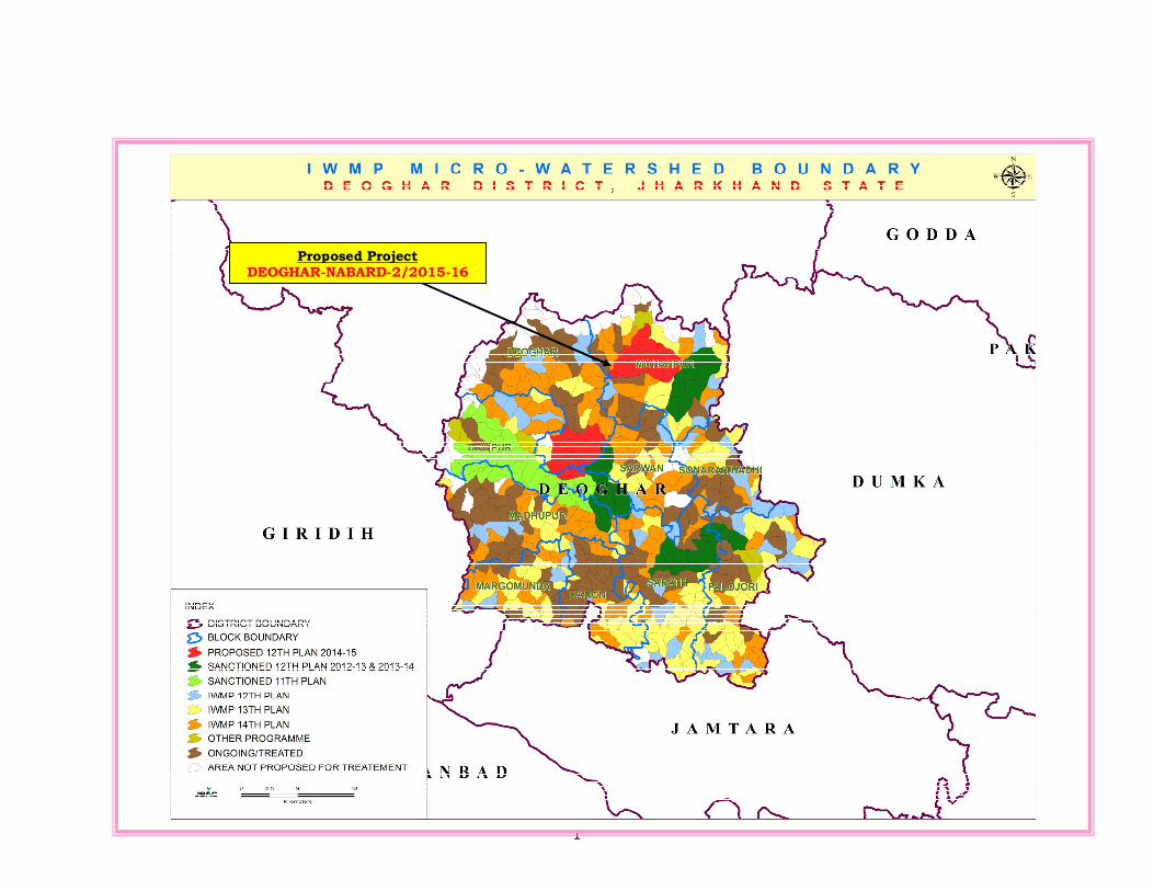
Proposed Project DEOGHAR-NABARD-2/2015-16
2
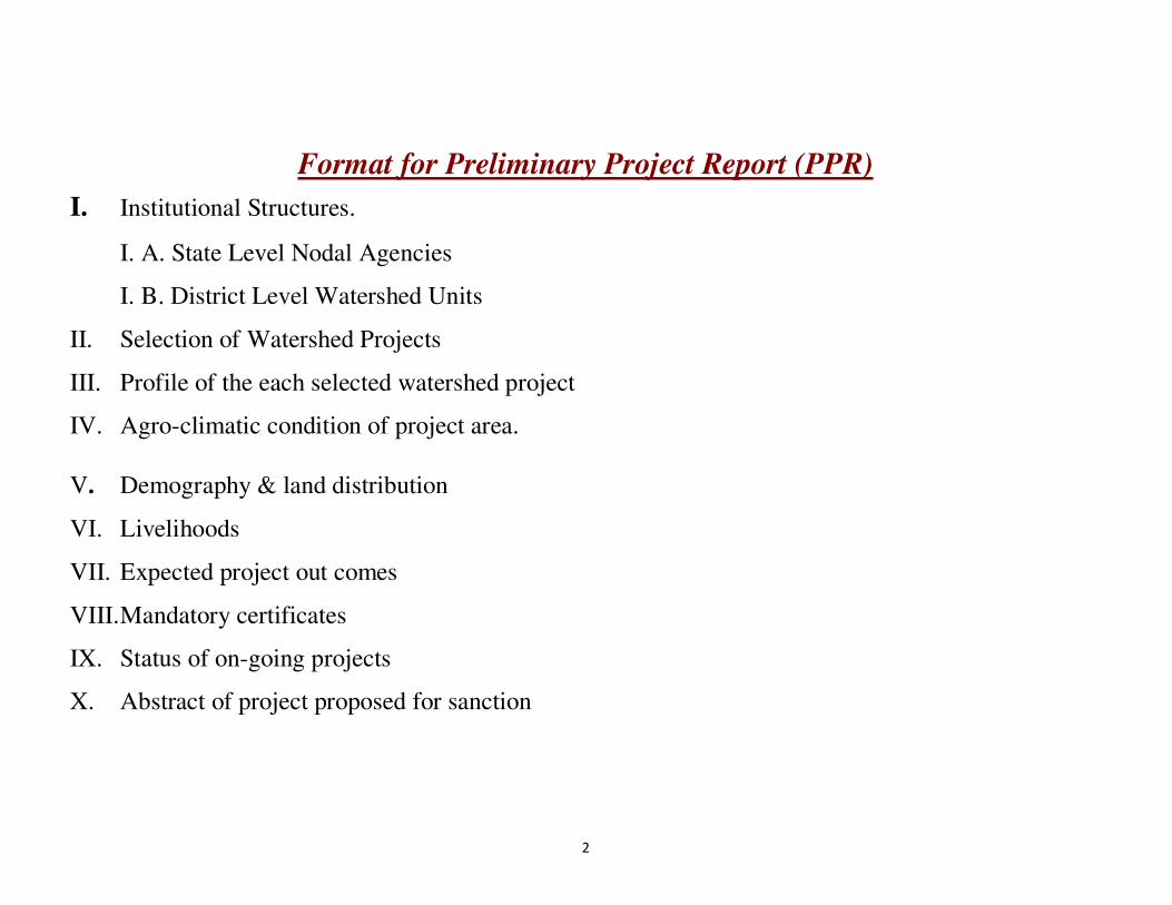
Format for Preliminary Project Report (PPR)
I. Institutional Structures.
I. A. State Level Nodal Agencies
I. B. District Level Watershed Units
II. Selection of Watershed Projects
III. Profile of the each selected watershed project
IV. Agro-climatic condition of project area.
V. Demography & land distribution
VI. Livelihoods
VII. Expected project out comes
VIII. Mandatory certificates
IX. Status of on-going projects
X. Abstract of project proposed for sanction

3
I. Institutional Structures
I. A. State Level Nodal Agencies (SLNAs):
Table-PPR 1: Details of SLNA
1 2 3 4 5 6
Sl.No. State Type of SLNA# Date of Notification Date of MoU with
DoLR Total no. of members of SLNA
1 Jharkhand
Jharkhand state Watershed Mission (No.
103/2009-10 dated 17/7/2009, Registered
Under society registration Act 21 of 1860, )
4673 Dated 20-06-09
Under Process 19 including (CEO)
Whether it is a Department /Mission/ Society/Authority/Others (pl. specify) Society (contd.)
Table-PPR 1: Details of SLNA (Contd.)
7 8
Chairperson CEO
Name Designation Name Designation Date of
Appointment Nature of
appointment Tenure (No.
of Years) Contact Ph. No./Fax/E-
Governing Body: Mr. Sudhir Prasad,
IAS
Development Commissioner
Mr B Nijalingappa, IFS
Chief Executive Officer State Level Nodal
Agency-Jharkhand State Watershed Mission Rural Development
Department Govt. of Jharkhand
Vide notification
no. 887 dated 22-02-2010
On deputation 3 Years
0651-2401974
Executive Committee-
Mr. Arun, IAS
Secretary, Rural
Development # APC/ ACS/ Dev. Commissioner/ Others (pl. specify) $ Deputation/ Contract

4
Table - PPR 2: Details of functionaries in the JSWM-SLNA
Details of the persons engaged in the SLNA- Jharkhand State Watershed Mission funded by DoLR
Sl.No Name &
Designation
Monthly
remuneration
Date of
Appointment
Nature of
appointment
Tenure
(No. of years)
Contract Ph. No. /
Subject of
Expertise
Qualification Experience Role
1.
Shri Madan
Sengupta
Administrative Officer
40,000 26-05-2010 On Contract 1 Yr. 9431114862
Law &
Administration
M.Sc. (Geology),
LLB.
About 32 Years
experience.
Administration, Supervision, EC
/GB Meetings organisations etc.
2.
Shri. Narayan
Kumar Mishra Technical Expert
(Agriculture /Agril. Engineering)
50,000 29
th May,
2010 On contract 1 Yr.
9431574367,
Watershed Management, Soil
and Water
Conservation, GIS & Remote
Sensing
Master of
Engineering (Ag), B Tech
(Agril.
Engineering). PGDRD, NET,
GATE
12years of
relevant experiences in
watershed mgt. and
development, agriculture dev., rural and social
dev.,
To give the
technical assistance &
Monitoring & evaluation of the
projects.
3.
Shri. Anupam
Bharti Technical Expert
(Livelihood)
50,000 29.05.10 On Contract 1 Yr.
9308351370
Horticulture, Rural development
M Sc (horticulture)
10 years of
relevant
experience in agriculture, rural dev.,
horticulture,
marketing, retail
To give the
technical
assistance & Monitoring &
evaluation of the projects.
4.
Shri. Kaushlendra
Kumar
Techninical Expert in Capacity Building
(Water Management)
50,000 29.05.2010 On contract 1 Yr. 9431071292
Soil & Water Conservation and
Watershed managemrnt
B Tech (Agricultural
Engineering ), M Tech in
Agricultural
Engineering (Soil and
Water Conservation)
and PGDRD
12 years of working
experiences in watershed
management,
soil and water conservation,
rural development
and GIS
To give the
technical assistance &
Monitoring & evaluation of the
projects
5.
Shri. Lakhan Lal
Mahato GIS Expert
40,000 29-05-2010 On Contract 1 Yr. 9470335956
[email protected] GIS & Remote
Sensing
M.Tech (Remote
Sensing)
14 years In the field of
GIS and
Remote Sensing
GIS, RS and Geodatabase
management
6. Smt. Jyoti Pushpa
Finance Officer 40,000 24.08.2010 On Contract 1 Yr.
9905582591 [email protected]
Accountancy CA 13 Years Finance Management
7.
Smt. Pratibha
Kumari
Accounts Officer
35,000 15.09.2010 On Contract 1 Yr. [email protected]
m Finance
M Com, MBA in Finance
5 Yrs 6 Months
Accounts Management
8. Smt. Shyama,
Account Assistant 25,000 1
st June 2010 On Contract 1 Yr. 9472018349 Finance
M Com, MBA in Finance
8 years Accounting
9. Shri. Ajeet Kumar
Ravi 25,000
26th May,
2010 On Contract 1 Yr.
9471764888/ [email protected]
Accounts M.com
(Finance), 7 years
Accounting, Auditing,
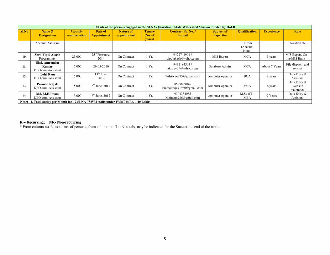
5
Details of the persons engaged in the SLNA- Jharkhand State Watershed Mission funded by DoLR
Sl.No Name &
Designation
Monthly
remuneration
Date of
Appointment
Nature of
appointment
Tenure
(No. of years)
Contract Ph. No. /
Subject of
Expertise
Qualification Experience Role
Account Assistant B Com (Account
Hons)
Taxation etc
10. Shri. Vipul Akash
Programmer 25,000
25th February,
2014 On Contract 1 Yr.
9472741901 /
[email protected] MIS Expert MCA 5 years
MIS Expert, On
line MIS Entry
11.
Shri. Amrendra
Kumar DEO-cum-Assistant
15,000 29-05-2010 On Contract 1 Yr. 9431184303 /
[email protected] Database Admin. MCA About 7 Years
File dispatch and
receipt
12. Tulsi Ram
DEO-cum-Assistant 15,000
13th June,
2012 On Contract 1 Yr. [email protected] computer operator BCA 8 years
Data Entry & Assistant
13. Promod Rajak
DEO-cum-Assistant 15,000 8
th June, 2012 On Contract 1 Yr.
8539809046 [email protected]
computer operator MCA 6 years Data Entry &
Website
maintance
14. Md. M.H.Imam
DEO-cum-Assistant 15,000 6
th June, 2012 On Contract 1 Yr.
9304334055
[email protected] computer operator
M.Sc (IT),
MBA 9 Years
Data Entry &
Assistant
Note: 1. Total outlay per Month for 12 SLNA-JSWM staffs under IWMP is Rs. 4.40 Lakhs
R – Recurring; NR- Non-recurring
* From column no. 3, totals no. of persons, from column no. 7 to 9, totals, may be indicated for the State at the end of the table.

6
Table PPR-3: Details of State Level Data Cell (SLDC) functionaries
1 2 3 4 5 6 7 8 9
S.
No
Total no. of
the persons
working in
the SLNA for
IWMP
Name &
Designation
Qualification Experience Work allocation Monthly
remuner
ation
(Rs.)
Total budget of
SLDC
(Rs. In Lakh)
Funding expected
from DoLR
(Rs. In Lakh)
R NR R NR
1
1
Shri. Vinod Kumar. V. H, Project Co-ordinator
M Tech (Water Resources)
6 years Creation and updation of Geodatabase under IWMP Project using satellite data
30,000.00
2
1
Shri. Anuj Shankar, MIS State Coordinator
MCA 4 years Updation of all the thematic layer using MIS Software development
15000.00
3
3
Shri. Abdul Saqoor, Field Supervisor
M Sc (IT) 5 years Updation of data using GIS & Remote Sensing software and collection of field level data under watershed project
10000.00
4 Vishal Kumar Assistant
B Sc (Fisheries), MBA, Rural Management
5 years Updation of data using GIS & Remote Sensing software and collection of field level data under watershed project
10000.00
5 Ratnesh Kumar Sharma Field Supervisor
M Sc (Math), Advance Diploma in Computer Application
6 years Updation of data using GIS & Remote Sensing software and collection of field level data under watershed project
10000.00
Total 5 65,000.00
Note: 1. Payment of above experts / staffs is being paid by state budget of JSAC 2. SLDC has been established at JSAC. However it is planning to establish SLDC in the office of JSWM. R – Recurring; NR- Non-recurring
* From column no. 3, totals no. of persons, from column no. 7 to 9, totals, may be indicated for the State at the end of the table.
7
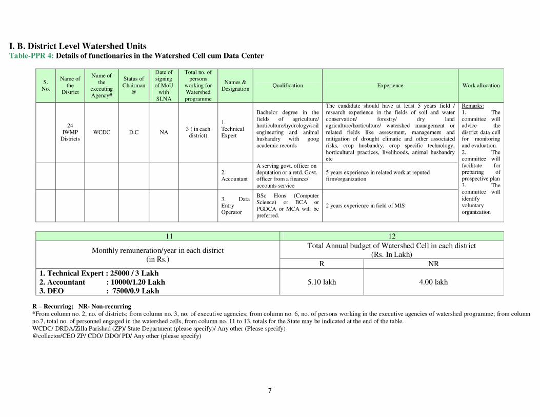
I. B. District Level Watershed Units Table-PPR 4: Details of functionaries in the Watershed Cell cum Data Center
S. No.
Name of the
District
Name of the
executing Agency#
Status of Chairman
@
Date of signing of MoU
with SLNA
Total no. of persons
working for Watershed programme
Names & Designation
Qualification Experience Work allocation
24
IWMP Districts
WCDC D.C NA 3 ( in each
district)
1. Technical Expert
Bachelor degree in the fields of agriculture/ horticulture/hydrology/soil engineering and animal husbandry with goog academic records
The candidate should have at least 5 years field / research experience in the fields of soil and water conservation/ forestry/ dry land agriculture/horticulture/ watershed management or related fields like assessment, management and mitigation of drought climatic and other associated risks, crop husbandry, crop specific technology, horticultural practices, livelihoods, animal husbandry etc
Remarks: 1. The committee will advice the district data cell for monitoring and evaluation. 2. The committee will facilitate for preparing of prospective plan 3. The committee will identify voluntary organization
2. Accountant
A serving govt. officer on deputation or a retd. Govt. officer from a finance/ accounts service
5 years experience in related work at reputed firm/organization
3. Data Entry Operator
BSc Hons (Computer Science) or BCA or PGDCA or MCA will be preferred.
2 years experience in field of MIS
11 12
Monthly remuneration/year in each district (in Rs.)
Total Annual budget of Watershed Cell in each district (Rs. In Lakh)
R NR
1. Technical Expert : 25000 / 3 Lakh
2. Accountant : 10000/1.20 Lakh
3. DEO : 7500/0.9 Lakh 5.10 lakh 4.00 lakh
R – Recurring; NR- Non-recurring
*From column no. 2, no. of districts; from column no. 3, no. of executive agencies; from column no. 6, no. of persons working in the executive agencies of watershed programme; from column no.7, total no. of personnel engaged in the watershed cells, from column no. 11 to 13, totals for the State may be indicated at the end of the table. WCDC/ DRDA/Zilla Parishad (ZP)/ State Department (please specify)/ Any other (Please specify) @collector/CEO ZP/ CDO/ DDO/ PD/ Any other (please specify)

8
II. SELECTION OF WATERSHED PROJECTS
Table-PPR 5: Status of District-wise area covered under the watershed programme* (MIS Table-M (SP) 2)
S. No. Names of Districts
Total micro-watersheds in the District
Micro-watersheds covered so far Net watersheds to be covered
Dept. of Land Resources Other Ministries/ Depts. Total watersheds covered
Pre-IWMP projects (DPAP +
DDP + IWDP) Any other watershed project
No. Area (Ha.) No. Area (Ha.) No. Area (Ha.) No. Area (Ha.) No. Area (Ha.)
1 DEOGHAR 455 2,48,150 38 30,400 33 18,375 71 48,775 335 1,62,863
Note: As per State Specific Perspective Plan (SPSP) 49 Micro-Watersheds ( Area: 36,512.00 Ha) is not available for treatment due to Urban areas,
Habitations, Mining areas, Water bodies etc.
STATUS OF IWMP PROJECTS SANCTIONED OF DEOGHAR DISTRICT
S.No District Block Name of Project No. of Cluster
No. of MWS
Treatable Area ( in Ha)
1.
DEOGHAR
DEVIPUR DEOGHAR-IWMP-1/2009-10 1 12 6819.30
2. DEVIPUR DEOGHAR-IWMP-2/2011-12 1 14 5091.36
3. MOHANPUR DEOGHAR-IWMP-3/2012-13 1 8 4857.21
4. DEVIPUR,
MADHUPUR, SARATH & SARWAN
DEOGHAR-IWMP-4/2012-13 1 9 4712.42
5. PALAJORI & SARATH
DEOGHAR-IWMP-5/2013-14 1 12
5178.53
TOTAL 5 55 26,658.82

9
Table-PPR 6: Prioritized list of projects proposed for sanction during the financial year 2015-16
S. No.
District Name of
the project
No. of micro-watersheds proposed to
covered
Proposed project area
(ha)
Type of project
(Hilly/Desert/Others)
Proposed cost (Rs. In
lakh)
Weight age under the criteria
i ii iii iv v vi vii viii ix x xi xii xiii Total
1 DEOGHAR NABARD 9 5111.5361 OTHERS 1022.3072 7.5 5 5 10 10 5 10 7.5 15 10 5 15 - 105
# Criteria and weight age for selection of watershed
S
No. Criteria Maximum
score Ranges & scores
i Poverty index(%of poor to population)
10 Above 80% (10) 80 to 50 % (7.5) 50 to 20 % (5) Below 20% (2.5)
ii % of SC/ST population 10 More than 40% (10) 20 to 40 % (5) Less than 20% (3)
iii Actual wages 5 Actual wages are significantly lower than minimum wages (5)
Actual wages are equal to or higher than minimum wages (0)
iv % of small and marginal farmers 10 More than 80% (10) 50 to 80% (5) Less than 50 (3)
v Ground water status 15 Over exploited (15) Critical (10) Sub critical (5) Safe (0)
vi Moisture index/ DPAP/DDP Block
10 -66.7 & below (10) DDP Block -33.3 to -66.6 (5) DPAP Block 0 to -33.2 (0) Non DPAP/DDP Block
vii Area under assured irrigation 15 Less than 10% (15) 10 to 20% (10) 20 to 30% (5) Above 30% (Reject)
viii Drinking water 10 No source (10) Problematic village (7.5) Partially covered (5) Fully covered (0)
ix Degraded land 15 High – above 20% (15) Medium – 10 to 20 % (10) Low – less than 10 % of TGA (5)
x Productivity potential of the land
10 Lands with low production & where productivity can be significantly enhanced with reasonable efforts (10)
Land with moderate production & where productivity can be enhanced with reasonable efforts (5)
Lands with high production & where productivity can be marginally enhanced with reasonable efforts (0)
xi Contiguity to another watershed that has already been developed/treated
10 Contiguous to previously treated watershed & contiguity within the micro watersheds in the project (10)
Contiguity with in the micro watersheds in the project but non contiguous to previously treated watershed (5)
Neither contiguous to previously treated watershed nor contiguity within the micro watersheds in the project (0)
xii Cluster approach in the plains (more than one contiguous micro-watersheds in the project)
15 Above 6 micro-watersheds in cluster (15)
4 to 6 micro watersheds in cluster (10)
2 to 4 micro watersheds in cluster (5)
xiii Cluster approach in the hills (More than one contiguous micro- watersheds in the project)
15 Above 5 micro-watersheds in cluster (15)
3 to 5 micro watersheds in cluster (10)
2 to 3 micro watersheds in cluster (5)
Total 150 150 90 41 2.5
10
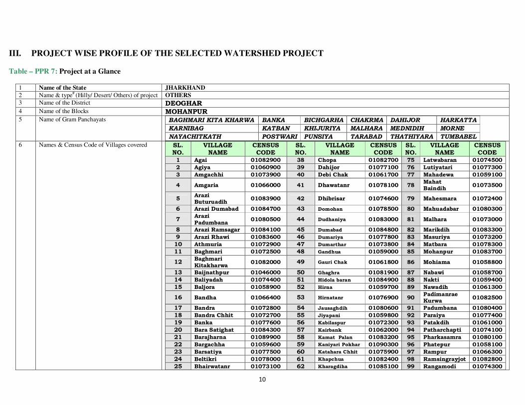
III. PROJECT WISE PROFILE OF THE SELECTED WATERSHED PROJECT Table – PPR 7: Project at a Glance
1 Name of the State JHARKHAND
2 Name & type# (Hilly/ Desert/ Others) of project OTHERS
3 Name of the District DEOGHAR
4 Name of the Blocks MOHANPUR 5 Name of Gram Panchayats BAGHMARI KITA KHARWA BANKA BICHGARHA CHAKRMA DAHIJOR HARKATTA
KARNIBAG KATBAN KHIJURIYA MALHARA MEDNIDIH MORNE
NAYACHITKATH POSTWARI PUNSIYA TARABAD THATHIYARA TUMBABEL
6 Names & Census Code of Villages covered SL. NO.
VILLAGE NAME
CENSUS CODE
SL. NO.
VILLAGE NAME
CENSUS CODE
SL. NO.
VILLAGE NAME
CENSUS CODE
1 Agai 01082900 38 Chopa 01082700 75 Latwabaran 01074500
2 Agiya 01060900 39 Dahijor 01077100 76 Lutiyatari 01077300
3 Amgachhi 01073900 40 Debi Chak 01061700 77 Mahadewa 01059100
4 Amgaria 01066000 41 Dhawatanr 01078100 78 Mahat Baindih
01073500
5 Arazi Buturuadih
01083900 42 Dhibrisar 01074600 79 Mahesmara 01072400
6 Arazi Dumabad 01084700 43 Domohan 01078500 80 Mahuadabar 01080300
7 Arazi Padumbana
01080500 44 Dudhaniya 01083000 81 Malhara 01073000
8 Arazi Ramsagar 01084100 45 Dumabad 01084800 82 Marikdih 01083300
9 Arazi Rhawi 01083600 46 Dumariya 01077800 83 Masuriya 01073200
10 Athmuria 01072900 47 Dumarthar 01073800 84 Matbara 01078300
11 Baghmari 01072500 48 Gandhua 01059000 85 Mohanpur 01083700
12 Baghmari Kitakharwa
01082000 49 Gauri Chak 01061800 86 Mohiama 01058800
13 Baijnathpur 01046000 50 Ghaghra 01081900 87 Nabawi 01058700
14 Baliyadah 01074400 51 Hidola baran 01084900 88 Nakti 01059400
15 Baljora 01058900 52 Hirna 01059700 89 Nawadih 01061300
16 Bandha 01066400 53 Hirnatanr 01076900 90 Padimanrae Kurwa
01082500
17 Bandra 01072800 54 Jausaghdih 01080600 91 Padumbana 01080400
18 Bandra Chhit 01072700 55 Jiyapani 01059800 92 Paraiya 01077400
19 Banka 01077600 56 Kabilaspur 01072300 93 Patakdih 01061000
20 Bara Satighat 01084300 57 Kairbank 01062000 94 Patharchapti 01074100
21 Barajharna 01089900 58 Kamat Palan 01083200 95 Pharkasamra 01080100
22 Bargachha 01059600 59 Kaniyari Pokhar 01090300 96 Phatepur 01058100
23 Barsatiya 01077500 60 Katahara Chhit 01075900 97 Rampur 01066300
24 Beltikri 01078000 61 Khapchua 01082400 98 Ramsingrayjot 01082800
25 Bhairwatanr 01073100 62 Kharagdiha 01085100 99 Rangamodi 01074300

11
Chak
26 Biarajpur 01072200 63 Kharaiadih 01083500 100 Ratanpur 01059900
27 Bichgarha 01056600 64 Khaspalag 01082300 101 Raturaydih 01077900
28 Birhabaran 01074200 65 Khaspalag Chhit 01082100 102 Rhabi 01083400
29 Bisnotar satighat
01084500 66 Kindua Nawadih 01065900 103 Singardih 01074000
30 Butatari 01082600 67 Kita Ramsagar 01084000 104 Singhraydih 01084200
31 Buturuadih 01083800 68 Kitapalag 01082200 105 Suthaniya 01073400
32 Chakarman 01083100 69 Kolhani Pathar 01077200 106 Tarabad 01073300
33 Chandayan 01084400 70 Kolhariya 01085200 107 Tasariya 01084600
34 Chauphal 01073600 71 Kulhariya 01078200 108 Teliya Chak 01073700
35 Chhata Kurum 01085000 72 Kulhariya 01080200 109 Tharhi 01072600
36 Chiguraydih 01078600 73 Kulhariya Chhit 01078400 110 Tilauna 01077700
37 Chihutia 01090400 74 Kurmakol 01059500 111 Tiurpahar 01090000
7 Names & Census Code of micro- watersheds Sl. No.
Micro-Watershed Code
Geographical Area of the Micro Watershed
Proposed Area to be treated
Budget (Proposed Area X 0.20) (Rs.in Lakh)
Remarks
1. 2A4A3b2f 689.0121 594.7617 118.9523
Proposed Area to be treated = RF + PF/Other +Rainfed +Permanent Pasture +Cultivable Wasteland
2. 2A4A3c2a 423.7360 368.1110 73.6222
3. 2A4A3c2b 749.3742 679.6449 135.9290
4. 2A4A3c2c 485.5196 454.7068 90.9414
5. 2A4A3c2d 534.4080 484.4533 96.8907
6. 2A4A3c3a 623.5816 575.0446 115.0089
7. 2A4A3c3b 646.2164 576.1833 115.2367
8. 2A4A3c3c 804.7837 691.0786 138.2157
9. 2A4A3c3d 785.3094 687.5519 137.5104
Grand Total 5741.9409 5111.5361 1022.3072
8 Four major reasons for selection of watershed � Lack of irrigation facilities
� Rain Fed area
� The area is mostly populated with S.C & S.T
� Productivity potential of the land. 9 Area of the Project (ha.) 5741.9409 10 Area proposed to be treated (ha.) 5111.5361 11 Project cost (Rs. In Lakhs) 1022.3072 12 Name & Address of proposed PIA SOIL CONSERVATION OFFICER, DEOGHAR 13 Any other (please specify)

12
Table – PPR 8: Details of previously identified DPAP /DDP areas proposed under IWMP (ha.) during the financial year 2015-16
Data Source: Jharkhand Space Application Center, Department of IT, Govt. of Jharkhand
1 2 3 4 5 6 7 8 9 10 11 12
S. No.
Names of Districts
Name of the project
proposed
Name of Block(s)
Type of Block
(DPAP/ DDP
/IWDP)
Area of District (ha.)
No. of IWMP projects
sanctioned in the District
Area of sanctioned
Projects
Net area to be covered
Area of the proposed project
Area proposed to be covered by schemes other
than DoLR
Net balance area
1. DEOGHAR NABARD MOHANPUR DPAP 2,84,662 5 26,658.82 1,31,200.37 5111.5361 NA 1,26,088.83
13
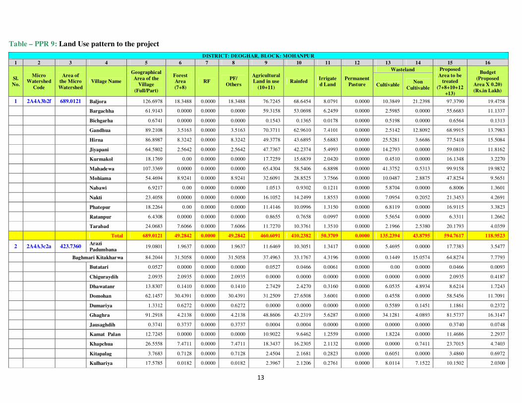
Table – PPR 9: Land Use pattern to the project
DISTRICT: DEOGHAR, BLOCK: MOHANPUR
1 2 3 4 5 6 7 8 9 10 11 12 13 14 15 16
Sl.
No.
Micro Watershed
Code
Area of the Micro
Watershed
Village Name
Geographical
Area of the
Village
(Full/Part)
Forest Area
(7+8)
RF PF/
Others
Agricultural Land in use
(10+11)
Rainfed Irrigate
d Land
Permanent
Pasture
Wasteland Proposed
Area to be treated
(7+8+10+12
+13)
Budget
(Proposed
Area X 0.20)
(Rs.in Lakh) Cultivable
Non
Cultivable
1 2A4A3b2f 689.0121 Baljora 126.6978 18.3488 0.0000 18.3488 76.7245 68.6454 8.0791 0.0000 10.3849 21.2398 97.3790 19.4758
Bargachha 61.9143 0.0000 0.0000 0.0000 59.3158 53.0698 6.2459 0.0000 2.5985 0.0000 55.6683 11.1337
Bichgarha 0.6741 0.0000 0.0000 0.0000 0.1543 0.1365 0.0178 0.0000 0.5198 0.0000 0.6564 0.1313
Gandhua 89.2108 3.5163 0.0000 3.5163 70.3711 62.9610 7.4101 0.0000 2.5142 12.8092 68.9915 13.7983
Hirna 86.8987 8.3242 0.0000 8.3242 49.3778 43.6895 5.6883 0.0000 25.5281 3.6686 77.5418 15.5084
Jiyapani 64.5802 2.5642 0.0000 2.5642 47.7367 42.2374 5.4993 0.0000 14.2793 0.0000 59.0810 11.8162
Kurmakol 18.1769 0.00 0.0000 0.0000 17.7259 15.6839 2.0420 0.0000 0.4510 0.0000 16.1348 3.2270
Mahadewa 107.3369 0.0000 0.0000 0.0000 65.4304 58.5406 6.8898 0.0000 41.3752 0.5313 99.9158 19.9832
Mohiama 54.4694 8.9241 0.0000 8.9241 32.6091 28.8525 3.7566 0.0000 10.0487 2.8875 47.8254 9.5651
Nabawi 6.9217 0.00 0.0000 0.0000 1.0513 0.9302 0.1211 0.0000 5.8704 0.0000 6.8006 1.3601
Nakti 23.4058 0.0000 0.0000 0.0000 16.1052 14.2499 1.8553 0.0000 7.0954 0.2052 21.3453 4.2691
Phatepur 18.2264 0.00 0.0000 0.0000 11.4146 10.0996 1.3150 0.0000 6.8119 0.0000 16.9115 3.3823
Ratanpur 6.4308 0.0000 0.0000 0.0000 0.8655 0.7658 0.0997 0.0000 5.5654 0.0000 6.3311 1.2662
Tarabad 24.0683 7.6066 0.0000 7.6066 11.7270 10.3761 1.3510 0.0000 2.1966 2.5380 20.1793 4.0359
Total 689.0121 49.2842 0.0000 49.2842 460.6091 410.2382 50.3709 0.0000 135.2394 43.8795 594.7617 118.9523
2 2A4A3c2a 423.7360 Arazi
Padumbana 19.0801 1.9637 0.0000 1.9637 11.6469 10.3051 1.3417 0.0000 5.4695 0.0000 17.7383 3.5477
Baghmari Kitakharwa 84.2044 31.5058 0.0000 31.5058 37.4963 33.1767 4.3196 0.0000 0.1449 15.0574 64.8274 7.7793
Butatari 0.0527 0.0000 0.0000 0.0000 0.0527 0.0466 0.0061 0.0000 0.00 0.0000 0.0466 0.0093
Chiguraydih 2.0935 2.0935 0.0000 2.0935 0.0000 0.0000 0.0000 0.0000 0.0000 0.0000 2.0935 0.4187
Dhawatanr 13.8307 0.1410 0.0000 0.1410 2.7429 2.4270 0.3160 0.0000 6.0535 4.8934 8.6214 1.7243
Domohan 62.1457 30.4391 0.0000 30.4391 31.2509 27.6508 3.6001 0.0000 0.4558 0.0000 58.5456 11.7091
Dumariya 1.3312 0.6272 0.0000 0.6272 0.0000 0.0000 0.0000 0.0000 0.5589 0.1451 1.1861 0.2372
Ghaghra 91.2918 4.2138 0.0000 4.2138 48.8606 43.2319 5.6287 0.0000 34.1281 4.0893 81.5737 16.3147
Jausaghdih 0.3741 0.3737 0.0000 0.3737 0.0004 0.0004 0.0000 0.0000 0.0000 0.0000 0.3740 0.0748
Kamat Palan 12.7245 0.0000 0.0000 0.0000 10.9022 9.6462 1.2559 0.0000 1.8224 0.0000 11.4686 2.2937
Khapchua 26.5558 7.4711 0.0000 7.4711 18.3437 16.2305 2.1132 0.0000 0.0000 0.7411 23.7015 4.7403
Kitapalag 3.7683 0.7128 0.0000 0.7128 2.4504 2.1681 0.2823 0.0000 0.6051 0.0000 3.4860 0.6972
Kulhariya 17.5785 0.0182 0.0000 0.0182 2.3967 2.1206 0.2761 0.0000 8.0114 7.1522 10.1502 2.0300

14
DISTRICT: DEOGHAR, BLOCK: MOHANPUR
1 2 3 4 5 6 7 8 9 10 11 12 13 14 15 16
Sl.
No.
Micro
Watershed
Code
Area of
the Micro
Watershed
Village Name
Geographical
Area of the
Village
(Full/Part)
Forest
Area
(7+8)
RF PF/
Others
Agricultural
Land in use
(10+11)
Rainfed Irrigate
d Land
Permanent
Pasture
Wasteland Proposed
Area to be
treated
(7+8+10+12
+13)
Budget
(Proposed
Area X 0.20)
(Rs.in Lakh) Cultivable
Non
Cultivable
Kulhariya Chhit 0.6509 0.1361 0.0000 0.1361 0.0000 0.0000 0.0000 0.0000 0.5149 0.0000 0.6509 0.0781
Mahuadabar 16.3039 10.0864 0.0000 10.0864 4.5354 4.0129 0.5225 0.0000 1.6821 0.0000 15.7814 3.1563
Matbara 29.0886 8.4282 0.0000 8.4282 0.0000 0.0000 0.0000 0.0000 18.9187 1.7417 27.3469 5.4694
Padumbana 33.2036 11.8153 0.0000 11.8153 14.3051 12.6571 1.6479 0.0000 7.0832 0.0000 31.5557 6.3111
Pharkasamra 9.4575 7.9680 0.0000 7.9680 1.1245 0.9949 0.1295 0.0000 0.0000 0.3650 8.9630 1.7926
Total 423.7360 117.9937 0.0000 117.9937 186.1086 164.6689 21.4397 0.0000 85.4485 34.1852 368.1110 73.6222
3 2A4A3c2b 749.3742 Agai 103.5773 22.9072 0.0000 22.9072 68.4999 61.2868 7.2130 0.0000 12.1702 0.0000 96.3642 19.2728
Arazi Dumabad 1.1288 0.0000 0.0000 0.0000 0.0000 0.0000 0.0000 0.0000 1.1288 0.0000 1.1288 0.1355
Beltikri 40.1931 9.2058 0.0000 9.2058 27.1204 23.9961 3.1243 0.0000 3.8670 0.0000 37.0689 7.4138
Butatari 19.8474 6.3169 0.0000 6.3169 11.6575 10.3145 1.3429 0.0000 1.8730 0.0000 18.5045 3.7009
Chakarman 59.2129 12.1697 0.0000 12.1697 3.7826 3.3469 0.4358 0.0000 35.4925 7.7681 51.0091 10.2018
Chhata Kurum
0.1860 0.0000 0.0000 0.0000 0.1860 0.1645 0.0214 0.0000 0.0000 0.0000 0.1645 0.0329
Chopa 224.0234 1.2732 0.0000 1.2732 110.4808 99.9409 10.5399 1.1111 101.6399 9.5184 203.9651 40.7930
Dahijor 6.3677 0.0000 0.0000 0.0000 3.0887 2.7329 0.3558 0.0000 0.0000 3.2790 2.7329 0.5466
Dhawatanr 21.5248 0.7558 0.0000 0.7558 1.4195 1.2559 0.1635 0.0000 19.3496 0.0000 21.3613 4.2723
Dudhaniya 69.3901 3.8174 0.0000 3.8174 14.1880 12.5536 1.6345 0.0000 36.7633 14.6213 53.1343 10.6269
Dumabad 45.1253 8.5132 0.0000 8.5132 1.8540 1.6405 0.2136 0.0000 34.7581 0.0000 44.9117 8.9823
Dumariya 28.5642 3.7477 0.0000 3.7477 3.8881 3.4402 0.4479 0.0000 20.8612 0.0672 28.0491 5.6098
Hidola baran 27.8578 0.0000 0.0000 0.0000 9.5083 8.4129 1.0954 0.0000 18.3495 0.0000 26.7624 5.3525
Hirnatanr 9.9407 0.0000 0.0000 0.0000 9.9407 8.7956 1.1452 0.0000 0.0000 0.0000 8.7956 1.7591
Kamat Palan 15.2973 5.8185 0.0000 5.8185 2.5908 2.2924 0.2985 0.0000 5.1799 1.7082 13.2907 2.6581
Khapchua 10.5076 4.6857 0.0000 4.6857 5.8219 5.1512 0.6707 0.0000 0.0000 0.0000 9.8369 1.9674
Kitapalag 2.4479 0.0663 0.0000 0.0663 1.6106 1.4251 0.1855 0.0000 0.7709 0.0000 2.2624 0.4525
Padimanrae Kurwa 24.7688 13.2684 0.0000 13.2684 5.1456 4.5528 0.5928 0.0000 6.3548 0.0000 24.1760 2.9011
Ramsingrayjot 8.2321 0.0000 0.0000 0.0000 8.2321 7.2838 0.9483 0.0000 0.0000 0.0000 7.2838 1.4568
Raturaydih 28.9690 0.0000 0.0000 0.0000 20.2972 17.9590 2.3382 0.0000 8.6717 0.0000 26.6307 5.3261
Tasariya 2.2120 0.0000 0.0000 0.0000 0.0000 0.0000 0.0000 0.0000 2.2120 0.0000 2.2120 0.4424
Total 749.3742 92.5458 0.0000 92.5458 309.3128 276.5456 32.7672 1.1111 309.4423 36.9621 679.6449 135.9290
4 2A4A3c2c 485.5196 Arazi
Buturuadih 13.9937 12.8919 0.0000 12.8919 0.0009 0.0008 0.0001 0.0000 1.1009 0.0000 13.9936 2.7987
15
DISTRICT: DEOGHAR, BLOCK: MOHANPUR
1 2 3 4 5 6 7 8 9 10 11 12 13 14 15 16
Sl.
No.
Micro
Watershed
Code
Area of
the Micro
Watershed
Village Name
Geographical
Area of the
Village
(Full/Part)
Forest
Area
(7+8)
RF PF/
Others
Agricultural
Land in use
(10+11)
Rainfed Irrigate
d Land
Permanent
Pasture
Wasteland Proposed
Area to be
treated
(7+8+10+12
+13)
Budget
(Proposed
Area X 0.20)
(Rs.in Lakh) Cultivable
Non
Cultivable
Arazi Dumabad 35.0490 11.2541 0.0000 11.2541 10.6430 9.4169 1.2261 0.0000 13.1519 0.0000 33.8229 4.0588
Arazi Ramsagar 9.5041 5.4513 0.0000 5.4513 4.0528 3.5859 0.4669 0.0000 0.00 0.0000 9.0372 1.0845
Arazi Rhawi 0.9771 0.00 0.0000 0.0000 0.0000 0.0000 0.0000 0.0000 0.9771 0.0000 0.9771 0.1954
Bara Satighat 28.1892 12.7142 0.0000 12.7142 15.4750 13.6922 1.7827 0.0000 0.0000 0.0000 26.4065 5.2813
Barajharna 36.6888 0.00 0.0000 0.0000 36.6888 32.4622 4.2265 0.0000 0.0000 0.00 32.4622 6.4924
Bisnotar satighat 11.0351 5.4450 0.0000 5.4450 5.5902 4.9462 0.6440 0.0000 0.00 0.00 10.3912 1.2469
Buturuadih 13.3349 0.0000 0.0000 0.0000 0.1447 0.1280 0.0167 0.0000 13.1901 0.0000 13.3182 2.6636
Chakarman 1.2187 0.0000 0.0000 0.0000 0.0000 0.0000 0.0000 0.0000 0.8816 0.3371 0.8816 0.1763
Chandayan 59.9100 24.2999 0.0000 24.2999 32.2102 28.4996 3.7106 0.0000 0.0000 3.3999 52.7995 10.5599
Chhata Kurum 24.6761 1.9655 0.0000 1.9655 17.4274 15.4198 2.0076 0.0000 5.2832 0.0000 22.6685 2.7202
Dumabad 4.4184 2.2216 0.0000 2.2216 0.0000 0.0000 0.0000 0.0000 2.1969 0.0000 4.4184 0.8837
Hidola baran 6.1449 0.0000 0.0000 0.0000 1.2431 1.0999 0.1432 0.0000 4.9018 0.0000 6.0017 1.2003
Kamat Palan 3.2075 0.0000 0.0000 0.0000 0.0000 0.0000 0.0000 0.0000 1.8097 1.3978 1.8097 0.3619
Kharagdiha 10.5398 0.0000 0.0000 0.0000 10.5398 9.3256 1.2142 0.0000 0.0000 0.0000 9.3256 1.8651
Kita Ramsagar 10.3438 0.5721 0.0000 0.5721 4.7741 4.2241 0.5500 0.0000 4.9976 0.0000 9.7939 1.1753
Kolhariya 7.1422 0.0000 0.0000 0.0000 7.1422 6.3194 0.8228 0.0000 0.0000 0.0000 6.3194 1.2639
Marikdih 0.0359 0.0000 0.0000 0.0000 0.0000 0.0000 0.0000 0.0000 0.0359 0.0000 0.0359 0.0072
Mohanpur 15.4516 0.0000 0.0000 0.0000 0.5534 0.4896 0.0638 0.0000 12.3740 2.5242 12.8636 2.5727
Singhraydih 38.8279 20.1561 0.0000 20.1561 18.6718 16.5208 2.1510 0.0000 0.0000 0.0000 36.6769 7.3354
Tasariya 44.7078 3.7685 0.0000 3.7685 26.5725 23.5113 3.0612 0.0000 14.3668 0.0000 41.6467 8.3293
Tiurpahar 110.1229 107.5690 0.0000 107.5690 1.6811 1.4875 0.1937 0.0000 0.0000 0.8727 109.0565 21.8113
Total 485.5196 208.3092 0.0000 208.3092 193.4110 171.1300 22.2809 0.0000 75.2676 8.5319 454.7068 90.9414
5 2A4A3c2d 534.4080 Arazi
Buturuadih 19.5467 4.8817 0.0000 4.8817 0.0000 0.0000 0.0000 0.0000 14.6650 0.0000 19.5467 3.9093
Arazi Rhawi 30.1425 0.0083 0.0000 0.0083 15.1688 13.4213 1.7474 0.0000 14.9653 0.0000 28.3950 5.6790
Baghmari Kitakharwa 38.2908 1.6167 0.0000 1.6167 21.2801 18.8286 2.4515 0.0000 9.0557 6.3383 29.5011 3.5401
Buturuadih 46.0491 3.7168 0.0000 3.7168 8.7799 7.7685 1.0114 0.0000 33.5524 0.0000 45.0377 9.0075
Chihutia 31.4384 13.2372 0.0000 13.2372 16.6782 14.7569 1.9213 0.0000 1.5230 0.0000 29.5171 5.9034
Ghaghra 74.8222 8.8649 0.0000 8.8649 38.1758 33.7780 4.3979 0.0000 25.0005 2.7810 67.6434 13.5287
Kamat Palan 16.6290 2.5511 0.0000 2.5511 6.2822 5.5585 0.7237 0.0000 7.6086 0.1871 15.7182 3.1436

16
DISTRICT: DEOGHAR, BLOCK: MOHANPUR
1 2 3 4 5 6 7 8 9 10 11 12 13 14 15 16
Sl.
No.
Micro
Watershed
Code
Area of
the Micro
Watershed
Village Name
Geographical
Area of the
Village
(Full/Part)
Forest
Area
(7+8)
RF PF/
Others
Agricultural
Land in use
(10+11)
Rainfed Irrigate
d Land
Permanent
Pasture
Wasteland Proposed
Area to be
treated
(7+8+10+12
+13)
Budget
(Proposed
Area X 0.20)
(Rs.in Lakh) Cultivable
Non
Cultivable
Kaniyari Pokhar 46.4533 6.6031 0.0000 6.6031 15.5934 13.7970 1.7964 0.0000 24.2568 0.0000 44.6570 5.3588
Khapchua 9.4140 0.7958 0.0000 0.7958 5.6978 5.0414 0.6564 0.0000 0.0000 2.9204 5.8372 1.1674
Kharaiadih 59.4739 4.2062 0.0000 4.2062 32.2902 28.5704 3.7198 0.0000 17.8538 5.1237 50.6303 10.1261
Khaspalag 15.0135 0.5467 0.0000 0.5467 12.5801 11.1308 1.4492 0.0000 1.8867 0.0000 13.5643 2.7129
Khaspalag Chhit 10.2851 0.0000 0.0000 0.0000 3.9929 3.5329 0.4600 0.0000 6.2922 0.0000 9.8252 1.1790
Kitapalag 20.8075 0.0000 0.0000 0.0000 7.7622 6.8680 0.8942 0.0000 13.0452 0.0000 19.9133 3.9827
Kulhariya 2.5177 0.0000 0.0000 0.0000 0.4720 0.4176 0.0544 0.0000 2.0457 0.0000 2.4634 0.4927
Marikdih 40.6022 17.7517 0.0000 17.7517 6.6568 5.8899 0.7669 0.0000 8.3854 7.8083 32.0270 6.4054
Matbara 0.2438 0.0000 0.0000 0.0000 0.0000 0.0000 0.0000 0.0000 0.2438 0.0000 0.2438 0.0488
Mohanpur 0.0377 0.0000 0.0000 0.0000 0.0000 0.0000 0.0000 0.0000 0.0377 0.0000 0.0377 0.0075
Rhabi 18.4334 0.0000 0.0000 0.0000 17.5700 15.5459 2.0241 0.0000 0.1420 0.7214 15.6879 3.1376
Tiurpahar 54.2070 54.0444 0.0000 54.0444 0.0000 0.0000 0.0000 0.0000 0.1627 0.0000 54.2070 10.8414
Total 534.4080 118.8246 0.0000 118.8246 208.9805 184.9060 24.0746 0.0000 180.7228 25.8801 484.4533 96.8907
6 2A4A3c3a 623.5816 Baljora 2.4265 1.5024 0.0000 1.5024 0.9241 0.8176 0.1065 0.0000 0.0000 0.0000 2.3201 0.4640
Banka 268.1884 78.4618 0.0000 78.4618 129.4878 117.1347 12.3531 1.1302 55.2261 3.8824 251.9528 50.3906
Barsatiya 25.8259 5.5062 0.0000 5.5062 16.6788 14.7574 1.9214 0.0000 3.6409 0.0000 23.9045 4.7809
Chiguraydih 41.8977 17.2140 0.0000 17.2140 24.6837 21.8401 2.8436 0.0000 0.0000 0.0000 39.0542 7.8108
Dhawatanr 0.0068 0.0000 0.0000 0.0000 0.0000 0.0000 0.0000 0.0000 0.0000 0.0068 0.0000 0.0000
Domohan 15.0907 6.1710 0.0000 6.1710 6.7666 5.9871 0.7795 0.0000 2.1531 0.0000 14.3112 2.8622
Dumariya 101.0546 54.3512 0.0000 54.3512 7.3593 6.5115 0.8478 0.0000 24.0733 15.2708 84.9360 16.9872
Gandhua 1.6435 1.6435 0.0000 1.6435 0.0000 0.0000 0.0000 0.0000 0.0000 0.0000 1.6435 0.3287
Hirna 26.7719 13.2887 0.0000 13.2887 8.7196 7.7151 1.0045 0.0000 4.7636 0.0000 25.7674 5.1535
Jiyapani 8.9442 0.2942 0.0000 0.2942 2.6702 2.3625 0.3076 0.0000 5.9798 0.0000 8.6366 1.7273
Kolhani Pathar 36.1300 16.0912 0.0000 16.0912 11.5134 10.1870 1.3263 0.0000 5.5693 2.9561 31.8476 3.8217
Kulhariya 0.6345 0.0062 0.0000 0.0062 0.0000 0.0000 0.0000 0.0000 0.5516 0.0767 0.5578 0.1116
Kulhariya Chhit 14.4049 2.2955 0.0000 2.2955 5.4840 4.8523 0.6318 0.0000 6.6254 0.0000 13.7731 1.6528
Lutiyatari 29.1635 1.3089 0.0000 1.3089 10.8967 9.6414 1.2553 0.0000 16.9579 0.0000 27.9082 5.5816
Matbara 0.2985 0.2868 0.0000 0.2868 0.0000 0.0000 0.0000 0.0000 0.0117 0.0000 0.2985 0.0597
Tarabad 4.9498 2.7631 0.0000 2.7631 1.0526 0.9313 0.1213 0.0000 0.1839 0.9503 3.8782 0.7756
Tilauna 46.1501 28.7934 0.0000 28.7934 16.4524 14.5570 1.8953 0.0000 0.9043 0.0000 44.2548 8.8510
17
DISTRICT: DEOGHAR, BLOCK: MOHANPUR
1 2 3 4 5 6 7 8 9 10 11 12 13 14 15 16
Sl.
No.
Micro
Watershed
Code
Area of
the Micro
Watershed
Village Name
Geographical
Area of the
Village
(Full/Part)
Forest
Area
(7+8)
RF PF/
Others
Agricultural
Land in use
(10+11)
Rainfed Irrigate
d Land
Permanent
Pasture
Wasteland Proposed
Area to be
treated
(7+8+10+12
+13)
Budget
(Proposed
Area X 0.20)
(Rs.in Lakh) Cultivable
Non
Cultivable
Total 623.5816 229.9783 0.0000 229.9783 242.6891 217.2952 25.3939 1.1302 126.6409 23.1431 575.0446 115.0089
7 2A4A3c3b 646.2164 Agiya 17.2221 0.00 0.0000 0.0000 14.5298 12.8560 1.6738 0.0000 2.6922 0.0000 15.5482 3.1096
Barsatiya 16.9200 3.6284 0.0000 3.6284 6.5296 5.7774 0.7522 0.0000 6.7620 0.0000 16.1678 3.2336
Bhairwatanr 56.3424 0.0000 0.0000 0.0000 50.4835 45.1676 5.3159 0.0000 4.4147 1.4442 49.5823 9.9165
Debi Chak 16.6241 0.3623 0.0000 0.3623 13.0156 11.5162 1.4994 0.0000 3.2461 0.0000 15.1247 3.0249
Gauri Chak 18.6940 0.0000 0.0000 0.0000 17.3170 15.3221 1.9949 0.0000 1.3770 0.0000 16.6991 3.3398
Kairbank 0.6434 0.00 0.0000 0.0000 0.6407 0.5669 0.0738 0.0000 0.0026 0.0000 0.5696 0.1139
Lutiyatari 33.6097 1.6077 0.0000 1.6077 13.8578 12.2614 1.5964 0.0000 13.9801 4.1641 27.8492 5.5698
Mahat Baindih 22.8833 0.00 0.0000 0.0000 8.6351 7.6403 0.9948 0.0000 14.2482 0.0000 21.8885 2.6266
Malhara 10.1385 0.00 0.0000 0.0000 2.9505 2.6106 0.3399 0.0000 6.6139 0.5742 9.2245 1.8449
Masuriya 11.7624 0.00 0.0000 0.0000 4.0373 3.5722 0.4651 0.0000 4.5416 3.1835 8.1138 1.6228
Nawadih 5.8975 1.1178 0.0000 1.1178 4.7796 4.2290 0.5506 0.0000 0.00 0.0000 5.3468 1.0694
Paraiya 31.7019 6.5921 0.0000 6.5921 25.1098 22.2172 2.8926 0.0000 0.00 0.0000 28.8093 5.7619
Patakdih 6.6647 0.00 0.0000 0.0000 3.5165 3.1114 0.4051 0.0000 3.1482 0.0000 6.2596 1.2519
Suthaniya 98.3811 6.3903 0.0000 6.3903 60.7343 54.3390 6.3953 0.0000 28.9871 2.2694 89.7164 17.9433
Tarabad 298.7314 7.6611 0.0000 7.6611 230.6467 210.9264 19.7203 2.2325 44.4636 13.7275 265.2836 53.0567
Total 646.2164 27.3599 0.0000 27.3599 456.7839 412.1136 44.6702 2.2325 134.4773 25.3629 576.1833 115.2367
8 2A4A3c3c 804.7837 Amgachhi 25.7722 0.1365 0.0000 0.1365 21.4437 18.9734 2.4703 0.0000 4.1921 0.0000 23.3019 4.6604
Amgaria 23.0405 2.3859 0.0000 2.3859 16.6634 14.7437 1.9196 0.0000 3.9912 0.0000 21.1209 4.2242
Athmuria 42.2371 0.0000 0.0000 0.0000 31.7492 28.0917 3.6575 0.0000 10.4879 0.0000 38.5796 7.7159
Baghmari 23.4597 0.0000 0.0000 0.0000 12.9429 11.4519 1.4910 0.0000 10.4966 0.0202 21.9484 4.3897
Baijnathpur 1.2896 0.0000 0.0000 0.0000 0.1170 0.1036 0.0135 0.0000 0.0000 1.1725 0.1036 0.0207
Baliyadah 78.3159 7.8124 0.0000 7.8124 49.7333 44.0040 5.7293 0.0000 18.4895 2.2807 70.3059 14.0612
Bandha 2.8373 0.0000 0.0000 0.0000 1.8067 1.5985 0.2081 0.0000 0.0000 1.0306 1.5985 0.3197
Bandra 36.5901 2.4156 0.0000 2.4156 27.6386 24.4546 3.1840 0.0000 3.2899 3.2461 30.1600 6.0320
Bandra Chhit 2.4802 1.4173 0.0000 1.4173 1.0629 0.9404 0.1224 0.0000 0.0000 0.0000 2.3578 0.4716
Bhairwatanr 22.5054 0.0000 0.0000 0.0000 15.8206 13.9980 1.8225 0.0000 5.5901 1.0947 19.5882 3.9176
Biarajpur 2.6311 0.0000 0.0000 0.0000 2.6304 2.3274 0.3030 0.0000 0.0007 0.0000 2.3281 0.4656
Birhabaran 14.9362 0.0000 0.0000 0.0000 8.2974 7.3415 0.9559 0.0000 6.6388 0.0000 13.9803 2.7961
Chauphal 10.3950 0.0000 0.0000 0.0000 8.9358 7.9064 1.0294 0.0000 1.4593 0.0000 9.3656 1.8731

18
DISTRICT: DEOGHAR, BLOCK: MOHANPUR
1 2 3 4 5 6 7 8 9 10 11 12 13 14 15 16
Sl.
No.
Micro
Watershed
Code
Area of
the Micro
Watershed
Village Name
Geographical
Area of the
Village
(Full/Part)
Forest
Area
(7+8)
RF PF/
Others
Agricultural
Land in use
(10+11)
Rainfed Irrigate
d Land
Permanent
Pasture
Wasteland Proposed
Area to be
treated
(7+8+10+12
+13)
Budget
(Proposed
Area X 0.20)
(Rs.in Lakh) Cultivable
Non
Cultivable
Dumarthar 0.0775 0.0000 0.0000 0.0000 0.0000 0.0000 0.0000 0.0000 0.0775 0.0000 0.0775 0.0155
Gauri Chak 6.3801 0.0000 0.0000 0.0000 4.7451 4.1985 0.5466 0.0000 1.6350 0.0000 5.8335 1.1667
Kabilaspur 38.4181 0.0000 0.0000 0.0000 31.4707 27.8453 3.6254 0.0000 6.9474 0.0000 34.7927 6.9585
Kindua Nawadih 9.4765 0.0320 0.0000 0.0320 4.9395 4.3705 0.5690 0.0000 4.5051 0.0000 8.9075 1.0689
Latwabaran 15.4981 6.1254 0.0000 6.1254 8.0948 7.1623 0.9325 0.0000 0.9117 0.3662 14.1994 2.8399
Mahat Baindih 34.3085 0.0000 0.0000 0.0000 22.2938 19.7256 2.5683 0.0000 8.6603 3.3543 28.3859 3.4063
Mahesmara 47.7038 2.1902 0.0000 2.1902 42.5083 37.6113 4.8970 0.0000 2.6172 0.3882 42.4186 8.4837
Malhara 166.7264 11.0837 0.0000 11.0837 108.5081 98.1564 10.3517 1.1097 11.6031 34.4218 121.9529 24.3906
Patharchapti 18.5339 3.9708 0.0000 3.9708 9.6900 8.5737 1.1163 0.0000 2.1540 2.7191 14.6985 2.9397
Rampur 12.4613 0.0000 0.0000 0.0000 7.2886 6.4490 0.8396 0.0000 2.8668 2.3059 9.3158 1.8632
Rangamodi Chak 15.3577 6.3174 0.0000 6.3174 5.5186 4.8829 0.6357 0.0000 2.9112 0.6104 14.1116 1.6934
Singardih 61.7959 21.5895 0.0000 21.5895 38.8713 34.3933 4.4780 0.0000 0.1024 1.2328 56.0852 11.2170
Tharhi 91.5557 27.9566 0.0000 27.9566 50.9931 45.6235 5.3696 0.0000 11.9806 0.6254 85.5608 17.1122
Total 804.7837 93.4333 0.0000 93.4333 533.7636 474.9273 58.8363 1.1097 121.6083 54.8688 691.0786 138.2157
9 2A4A3c3d 785.3094 Amgachhi 2.7208 0.0000 0.0000 0.0000 2.7208 2.4074 0.3134 0.0000 0.0000 0.0000 2.4074 0.4815
Baliyadah 9.7413 3.9278 0.0000 3.9278 3.9706 3.5132 0.4574 0.0000 1.8429 0.0000 9.2839 1.8568
Chauphal 56.5162 0.0000 0.0000 0.0000 43.5576 38.5397 5.0178 0.0000 12.9587 0.0000 51.4984 10.2997
Chopa 1.7316 0.0000 0.0000 0.0000 0.7612 0.6735 0.0877 0.0000 0.9705 0.0000 1.6439 0.3288
Dahijor 256.1878 4.5523 0.0000 4.5523 171.7364 155.3527 16.3836 1.1724 36.5405 42.1863 197.6179 39.5236
Dhibrisar 12.1788 1.3155 0.0000 1.3155 0.6788 0.6006 0.0782 0.0000 10.1845 0.0000 12.1006 2.4201
Dumariya 74.1674 16.6274 0.0000 16.6274 47.6511 42.1617 5.4894 0.0000 9.8888 0.0000 68.6780 13.7356
Dumarthar 107.4551 19.6336 0.0000 19.6336 51.8020 46.3472 5.4547 0.0000 36.0195 0.0000 102.0003 20.4001
Katahara
Chhit 3.0219 0.0000 0.0000 0.0000 2.4946 2.2072 0.2874 0.0000 0.5273 0.0000 2.7345 0.5469
Kolhani Pathar 42.9111 14.1905 0.0000 14.1905 27.7537 24.5565 3.1972 0.0000 0.9669 0.0000 39.7139 4.7657
Latwabaran 23.0320 14.8318 0.0000 14.8318 1.2749 1.1281 0.1469 0.0000 6.9253 0.0000 22.8852 4.5770
Lutiyatari 48.8232 0.0000 0.0000 0.0000 31.5667 27.9302 3.6365 0.0000 13.6578 3.5987 41.5880 8.3176
Mahat Baindih 79.0929 0.0000 0.0000 0.0000 43.4217 38.4195 5.0022 0.0000 35.6712 0.0000 74.0907 8.8909
Suthaniya 24.6602 0.0743 0.0000 0.0743 21.0960 18.6657 2.4303 0.0000 3.4899 0.0000 22.2300 4.4460
Teliya Chak 43.0691 0.0000 0.0000 0.0000 34.6338 30.6440 3.9898 0.0000 8.4353 0.0000 39.0793 7.8159
19
DISTRICT: DEOGHAR, BLOCK: MOHANPUR
1 2 3 4 5 6 7 8 9 10 11 12 13 14 15 16
Sl.
No.
Micro
Watershed
Code
Area of
the Micro
Watershed
Village Name
Geographical
Area of the
Village
(Full/Part)
Forest
Area
(7+8)
RF PF/
Others
Agricultural
Land in use
(10+11)
Rainfed Irrigate
d Land
Permanent
Pasture
Wasteland Proposed
Area to be
treated
(7+8+10+12
+13)
Budget
(Proposed
Area X 0.20)
(Rs.in Lakh) Cultivable
Non
Cultivable
Total 785.3094 75.1531 0.0000 75.1531 485.1198 433.1472 51.9726 1.1724 178.0791 45.7850 687.5519 137.5104
Grand Total 5741.9409 1012.8821 0.0000 1012.8821 3076.7783 2744.9720 331.8063 6.7559 1346.9261 298.5985 5111.5361 1022.3072
Data Source: Jharkhand Space Application Center, Department of IT, Govt. of Jharkhand
20
IV. AGRO–CLIMATIC CONDITION Briefly describe the agro- climatic condition of project area including the Agro-climatic zone of project area, soil types, rainfall, major crops, etc.
Table – PPR 10: Details of Agro – climatic condition
1 2 3 4 5 6 7 8 9
S. No.
Name of the Project
Name of the Agro-climatic zone
covers project area Area in ha
Names of the villages
Major soil types Topography
Average rainfall in mm (preceding 5
years average)
Major crops
a) Type b) Area in ha a) Name b) Area in
ha
1 NABARD
Zone IV Central and
North Eastern Plateau
5741.9409 Detailed
enclosed in
Table-PPR-7
Sandy, Sandy loam
Red laterite soil
5741.9409 Undulating
moderate to steep
Slope
1162 mm
Paddy 2400
Wheat 275
Pulses 165
Vegetables 130
TOTAL 2970
Table-PPR 11: Details of flood and drought in the project area
1 2 3 4 5
Sl. No. Particulars Villages Periodicity
Not affected Annual Any other (please specify)
1 Flood No. of villages NA NA NA
Name(s) of villages
2 Drought
No. of villages 111
Name(s) of villages Detailed enclosed in
Table-PPR 7
Drought prone Area affected by severe scarcity in rain fall annually
Rain shadow area

21
Table-PPR 12: Details of soil erosion in the project area
1 2 3 4 5
Cause Type of erosion Area affected (ha) Run off
(mm/ year) Average soil loss (Tones/ ha/ year)
Water erosion a Sheet 825
950 49.80 b Rill 150 c Gully 45
Sub-Total 1020
Wind erosion -
Total 1020 950
22
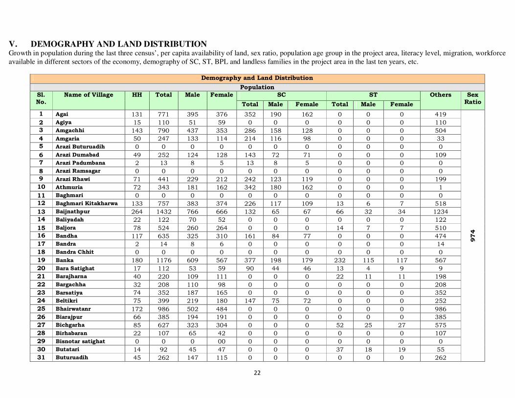
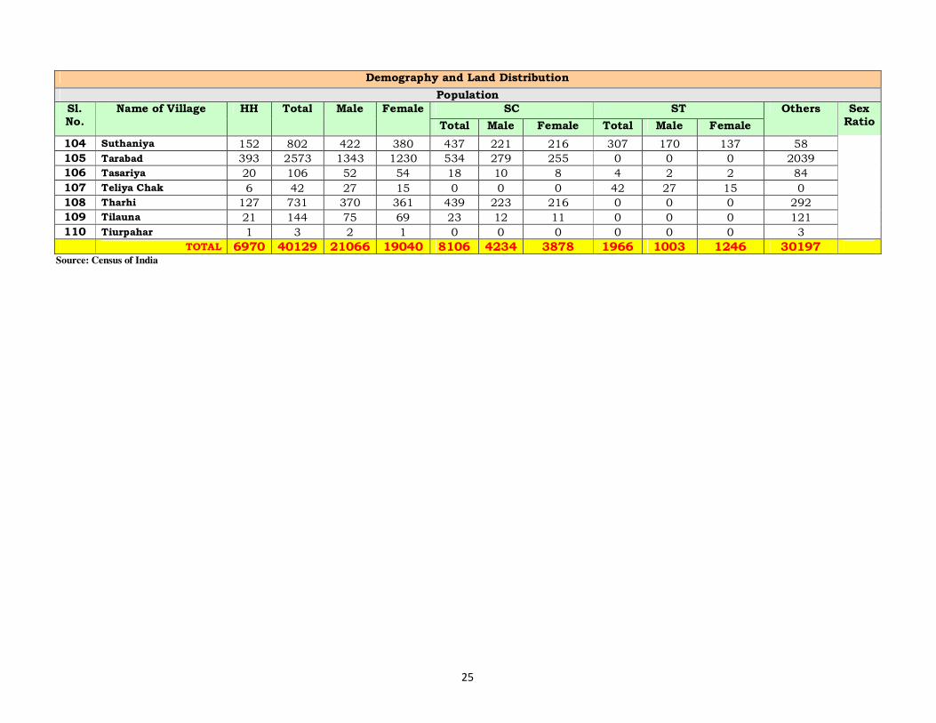
V. DEMOGRAPHY AND LAND DISTRIBUTION
Growth in population during the last three census’, per capita availability of land, sex ratio, population age group in the project area, literacy level, migration, workforce available in different sectors of the economy, demography of SC, ST, BPL and landless families in the project area in the last ten years, etc.
Demography and Land Distribution
Population
Sl. No.
Name of Village HH Total Male Female SC ST Others Sex Ratio Total Male Female Total Male Female
1 Agai 131 771 395 376 352 190 162 0 0 0 419
974
2 Agiya 15 110 51 59 0 0 0 0 0 0 110
3 Amgachhi 143 790 437 353 286 158 128 0 0 0 504
4 Amgaria 50 247 133 114 214 116 98 0 0 0 33
5 Arazi Buturuadih 0 0 0 0 0 0 0 0 0 0 0
6 Arazi Dumabad 49 252 124 128 143 72 71 0 0 0 109
7 Arazi Padumbana 2 13 8 5 13 8 5 0 0 0 0
8 Arazi Ramsagar 0 0 0 0 0 0 0 0 0 0 0
9 Arazi Rhawi 71 441 229 212 242 123 119 0 0 0 199
10 Athmuria 72 343 181 162 342 180 162 0 0 0 1
11 Baghmari 0 0 0 0 0 0 0 0 0 0 0
12 Baghmari Kitakharwa 133 757 383 374 226 117 109 13 6 7 518
13 Baijnathpur 264 1432 766 666 132 65 67 66 32 34 1234
14 Baliyadah 22 122 70 52 0 0 0 0 0 0 122
15 Baljora 78 524 260 264 0 0 0 14 7 7 510
16 Bandha 117 635 325 310 161 84 77 0 0 0 474
17 Bandra 2 14 8 6 0 0 0 0 0 0 14
18 Bandra Chhit 0 0 0 0 0 0 0 0 0 0 0
19 Banka 180 1176 609 567 377 198 179 232 115 117 567
20 Bara Satighat 17 112 53 59 90 44 46 13 4 9 9
21 Barajharna 40 220 109 111 0 0 0 22 11 11 198
22 Bargachha 32 208 110 98 0 0 0 0 0 0 208
23 Barsatiya 74 352 187 165 0 0 0 0 0 0 352
24 Beltikri 75 399 219 180 147 75 72 0 0 0 252
25 Bhairwatanr 172 986 502 484 0 0 0 0 0 0 986
26 Biarajpur 66 385 194 191 0 0 0 0 0 0 385
27 Bichgarha 85 627 323 304 0 0 0 52 25 27 575
28 Birhabaran 22 107 65 42 0 0 0 0 0 0 107
29 Bisnotar satighat 0 0 0 00 0 0 0 0 0 0 0
30 Butatari 14 92 45 47 0 0 0 37 18 19 55
31 Buturuadih 45 262 147 115 0 0 0 0 0 0 262

23
Demography and Land Distribution
Population
Sl. No.
Name of Village HH Total Male Female SC ST Others Sex Ratio Total Male Female Total Male Female
32 Chakarman 188 1136 578 558 210 90 120 6 2 4 920
974
33 Chandayan 3 7 3 4 0 0 0 0 0 0 7
34 Chauphal 71 445 229 216 0 0 0 0 0 0 445
35 Chhata Kurum 11 62 27 35 0 0 0 0 0 0 62
36 Chiguraydih 2 12 5 7 0 0 0 0 0 0 12
37 Chihutia 27 190 106 84 0 0 0 0 0 0 190
38 Chopa 58 353 191 162 0 0 0 0 0 0 353
39 Dahijor 309 1975 1135 840 192 114 78 77 43 34 1706
40 Debi Chak 52 247 127 120 120 60 60 0 0 0 127
41 Dhawatanr 20 129 67 62 0 0 0 0 0 0 129
42 Dhibrisar 1 4 4 0 0 0 0 0 0 0 4
43 Domohan 45 281 137 144 0 0 0 0 0 0 281
44 Dudhaniya 65 420 229 191 209 113 96 6 2 4 205
45 Dumabad 91 51 40 0 0 0 0 0 0 91 91
46 Dumariya 92 634 338 296 125 69 56 0 0 0 509
47 Dumarthar 95 629 335 294 342 177 165 0 0 0 287
48 Gandhua 25 166 92 74 0 0 0 0 0 0 166
49 Gauri Chak 39 272 144 128 0 0 0 0 0 0 272
50 Ghaghra 106 639 329 310 148 77 71 24 12 12 467
51 Hidola baran 95 639 329 310 0 0 0 122 61 61 517
52 Hirna 29 220 121 99 29 20 9 0 0 0 191
53 Hirnatanr 50 309 161 148 61 32 29 0 0 0 248
54 Jausaghdih 28 165 85 80 105 56 49 0 0 0 60
55 Jiyapani 83 494 255 239 0 0 0 0 0 0 494
56 Kabilaspur 3 45 24 21 0 0 0 0 0 0 45
57 Kairbank 44 260 136 124 53 28 25 0 0 0 207
58 Kamat Palan 21 127 66 61 5 4 1 0 0 0 122
59 Kaniyari Pokhar 17 87 47 40 78 42 36 0 0 0 9
60 Katahara Chhit 0 0 0 0 0 0 0 0 0 0 0
61 Khapchua 25 120 64 56 0 0 0 0 0 0 120
62 Kharagdiha 23 131 66 65 0 0 0 0 0 0 131
63 Kharaiadih 22 128 56 72 0 0 0 119 49 70 9
64 Khaspalag 54 308 153 155 0 0 0 0 0 0 308
65 Khaspalag Chhit 20 131 75 56 0 0 0 0 0 0 131
66 Kindua Nawadih 85 405 210 195 405 210 195 0 0 0 0
67 Kita Ramsagar 0 0 0 0 0 0 0 0 0 0 0
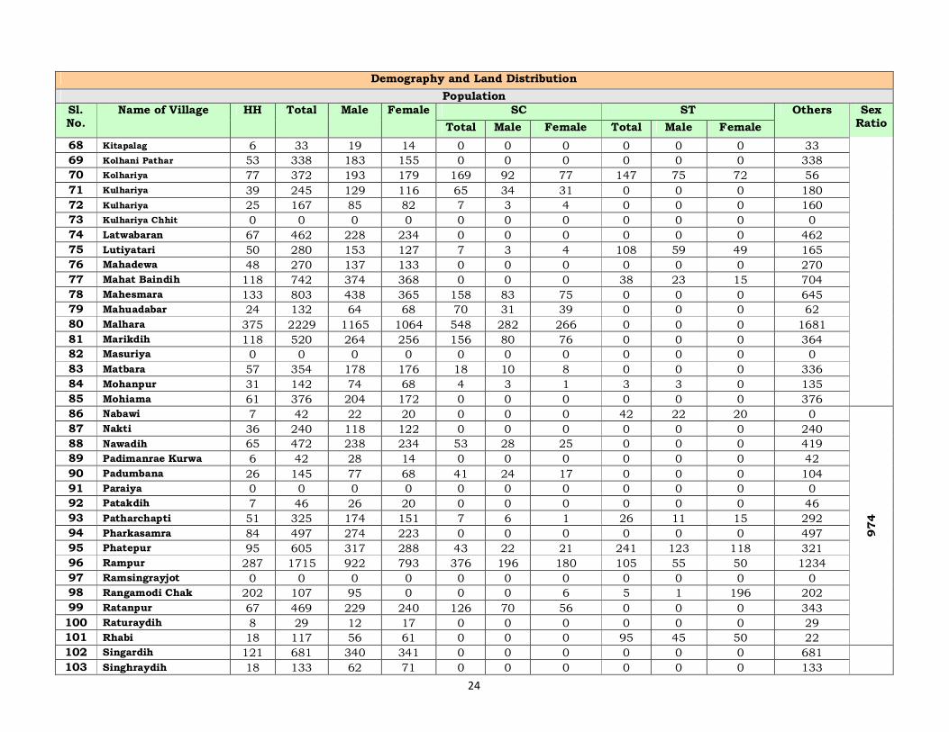
24
Demography and Land Distribution
Population
Sl. No.
Name of Village HH Total Male Female SC ST Others Sex Ratio Total Male Female Total Male Female
68 Kitapalag 6 33 19 14 0 0 0 0 0 0 33
69 Kolhani Pathar 53 338 183 155 0 0 0 0 0 0 338
70 Kolhariya 77 372 193 179 169 92 77 147 75 72 56
71 Kulhariya 39 245 129 116 65 34 31 0 0 0 180
72 Kulhariya 25 167 85 82 7 3 4 0 0 0 160
73 Kulhariya Chhit 0 0 0 0 0 0 0 0 0 0 0
74 Latwabaran 67 462 228 234 0 0 0 0 0 0 462
75 Lutiyatari 50 280 153 127 7 3 4 108 59 49 165
76 Mahadewa 48 270 137 133 0 0 0 0 0 0 270
77 Mahat Baindih 118 742 374 368 0 0 0 38 23 15 704
78 Mahesmara 133 803 438 365 158 83 75 0 0 0 645
79 Mahuadabar 24 132 64 68 70 31 39 0 0 0 62
80 Malhara 375 2229 1165 1064 548 282 266 0 0 0 1681
81 Marikdih 118 520 264 256 156 80 76 0 0 0 364
82 Masuriya 0 0 0 0 0 0 0 0 0 0 0
83 Matbara 57 354 178 176 18 10 8 0 0 0 336
84 Mohanpur 31 142 74 68 4 3 1 3 3 0 135
85 Mohiama 61 376 204 172 0 0 0 0 0 0 376
86 Nabawi 7 42 22 20 0 0 0 42 22 20 0
974
87 Nakti 36 240 118 122 0 0 0 0 0 0 240
88 Nawadih 65 472 238 234 53 28 25 0 0 0 419
89 Padimanrae Kurwa 6 42 28 14 0 0 0 0 0 0 42
90 Padumbana 26 145 77 68 41 24 17 0 0 0 104
91 Paraiya 0 0 0 0 0 0 0 0 0 0 0
92 Patakdih 7 46 26 20 0 0 0 0 0 0 46
93 Patharchapti 51 325 174 151 7 6 1 26 11 15 292
94 Pharkasamra 84 497 274 223 0 0 0 0 0 0 497
95 Phatepur 95 605 317 288 43 22 21 241 123 118 321
96 Rampur 287 1715 922 793 376 196 180 105 55 50 1234
97 Ramsingrayjot 0 0 0 0 0 0 0 0 0 0 0
98 Rangamodi Chak 202 107 95 0 0 0 6 5 1 196 202
99 Ratanpur 67 469 229 240 126 70 56 0 0 0 343
100 Raturaydih 8 29 12 17 0 0 0 0 0 0 29
101 Rhabi 18 117 56 61 0 0 0 95 45 50 22
102 Singardih 121 681 340 341 0 0 0 0 0 0 681
103 Singhraydih 18 133 62 71 0 0 0 0 0 0 133
25
Demography and Land Distribution
Population
Sl. No.
Name of Village HH Total Male Female SC ST Others Sex Ratio Total Male Female Total Male Female
104 Suthaniya 152 802 422 380 437 221 216 307 170 137 58
105 Tarabad 393 2573 1343 1230 534 279 255 0 0 0 2039
106 Tasariya 20 106 52 54 18 10 8 4 2 2 84
107 Teliya Chak 6 42 27 15 0 0 0 42 27 15 0
108 Tharhi 127 731 370 361 439 223 216 0 0 0 292
109 Tilauna 21 144 75 69 23 12 11 0 0 0 121
110 Tiurpahar 1 3 2 1 0 0 0 0 0 0 3
TOTAL 6970 40129 21066 19040 8106 4234 3878 1966 1003 1246 30197 Source: Census of India
26
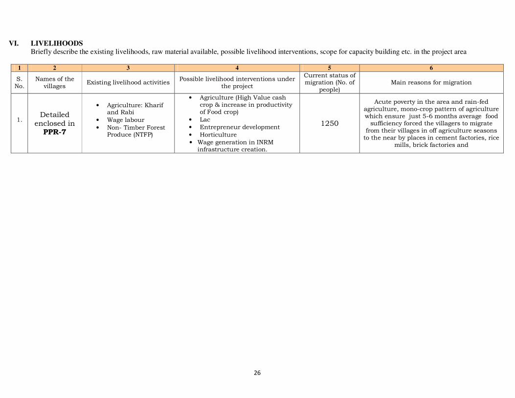
VI. LIVELIHOODS Briefly describe the existing livelihoods, raw material available, possible livelihood interventions, scope for capacity building etc. in the project area
1 2 3 4 5 6
S. No.
Names of the villages
Existing livelihood activities Possible livelihood interventions under
the project
Current status of migration (No. of
people) Main reasons for migration
1. Detailed
enclosed in PPR-7
• Agriculture: Kharif and Rabi
• Wage labour
• Non- Timber Forest Produce (NTFP)
• Agriculture (High Value cash crop & increase in productivity of Food crop)
• Lac
• Entrepreneur development
• Horticulture
• Wage generation in INRM infrastructure creation.
1250
Acute poverty in the area and rain-fed agriculture, mono-crop pattern of agriculture which ensure just 5-6 months average food sufficiency forced the villagers to migrate from their villages in off agriculture seasons to the near by places in cement factories, rice
mills, brick factories and
27
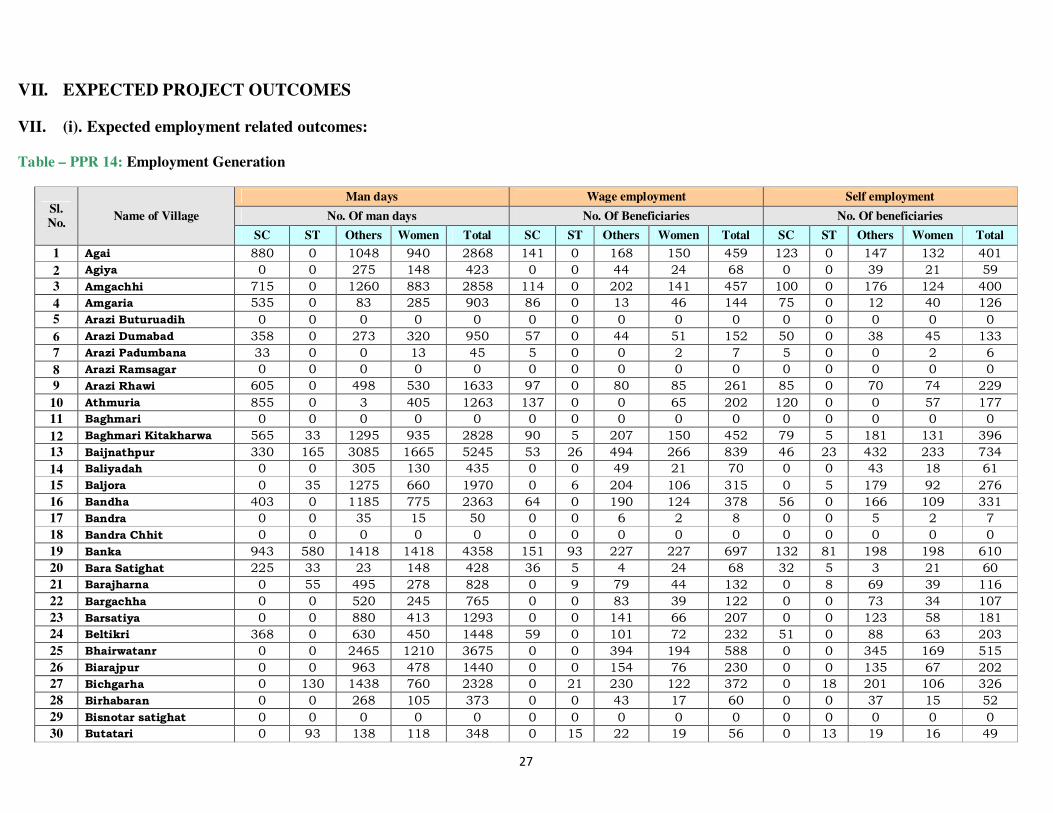
VII. EXPECTED PROJECT OUTCOMES
VII. (i). Expected employment related outcomes:
Table – PPR 14: Employment Generation
Sl.
No. Name of Village
Man days Wage employment Self employment
No. Of man days No. Of Beneficiaries No. Of beneficiaries
SC ST Others Women Total SC ST Others Women Total SC ST Others Women Total
1 Agai 880 0 1048 940 2868 141 0 168 150 459 123 0 147 132 401
2 Agiya 0 0 275 148 423 0 0 44 24 68 0 0 39 21 59
3 Amgachhi 715 0 1260 883 2858 114 0 202 141 457 100 0 176 124 400
4 Amgaria 535 0 83 285 903 86 0 13 46 144 75 0 12 40 126
5 Arazi Buturuadih 0 0 0 0 0 0 0 0 0 0 0 0 0 0 0
6 Arazi Dumabad 358 0 273 320 950 57 0 44 51 152 50 0 38 45 133
7 Arazi Padumbana 33 0 0 13 45 5 0 0 2 7 5 0 0 2 6
8 Arazi Ramsagar 0 0 0 0 0 0 0 0 0 0 0 0 0 0 0
9 Arazi Rhawi 605 0 498 530 1633 97 0 80 85 261 85 0 70 74 229
10 Athmuria 855 0 3 405 1263 137 0 0 65 202 120 0 0 57 177
11 Baghmari 0 0 0 0 0 0 0 0 0 0 0 0 0 0 0
12 Baghmari Kitakharwa 565 33 1295 935 2828 90 5 207 150 452 79 5 181 131 396
13 Baijnathpur 330 165 3085 1665 5245 53 26 494 266 839 46 23 432 233 734
14 Baliyadah 0 0 305 130 435 0 0 49 21 70 0 0 43 18 61
15 Baljora 0 35 1275 660 1970 0 6 204 106 315 0 5 179 92 276
16 Bandha 403 0 1185 775 2363 64 0 190 124 378 56 0 166 109 331
17 Bandra 0 0 35 15 50 0 0 6 2 8 0 0 5 2 7
18 Bandra Chhit 0 0 0 0 0 0 0 0 0 0 0 0 0 0 0
19 Banka 943 580 1418 1418 4358 151 93 227 227 697 132 81 198 198 610
20 Bara Satighat 225 33 23 148 428 36 5 4 24 68 32 5 3 21 60
21 Barajharna 0 55 495 278 828 0 9 79 44 132 0 8 69 39 116
22 Bargachha 0 0 520 245 765 0 0 83 39 122 0 0 73 34 107
23 Barsatiya 0 0 880 413 1293 0 0 141 66 207 0 0 123 58 181
24 Beltikri 368 0 630 450 1448 59 0 101 72 232 51 0 88 63 203
25 Bhairwatanr 0 0 2465 1210 3675 0 0 394 194 588 0 0 345 169 515
26 Biarajpur 0 0 963 478 1440 0 0 154 76 230 0 0 135 67 202
27 Bichgarha 0 130 1438 760 2328 0 21 230 122 372 0 18 201 106 326
28 Birhabaran 0 0 268 105 373 0 0 43 17 60 0 0 37 15 52
29 Bisnotar satighat 0 0 0 0 0 0 0 0 0 0 0 0 0 0 0
30 Butatari 0 93 138 118 348 0 15 22 19 56 0 13 19 16 49

28
Sl.
No. Name of Village
Man days Wage employment Self employment
No. Of man days No. Of Beneficiaries No. Of beneficiaries
SC ST Others Women Total SC ST Others Women Total SC ST Others Women Total
31 Buturuadih 0 0 655 288 943 0 0 105 46 151 0 0 92 40 132
32 Chakarman 525 15 2300 1395 4235 84 2 368 223 678 74 2 322 195 593
33 Chandayan 0 0 18 10 28 0 0 3 2 4 0 0 2 1 4
34 Chauphal 0 0 1113 540 1653 0 0 178 86 264 0 0 156 76 231
35 Chhata Kurum 0 0 155 88 243 0 0 25 14 39 0 0 22 12 34
36 Chiguraydih 0 0 30 18 48 0 0 5 3 8 0 0 4 2 7
37 Chihutia 0 0 475 210 685 0 0 76 34 110 0 0 67 29 96
38 Chopa 0 0 883 405 1288 0 0 141 65 206 0 0 124 57 180
39 Dahijor 480 193 4265 2100 7038 77 31 682 336 1126 67 27 597 294 985
40 Debi Chak 300 0 318 300 918 48 0 51 48 147 42 0 44 42 128
41 Dhawatanr 0 0 323 155 478 0 0 52 25 76 0 0 45 22 67
42 Dhibrisar 0 0 10 0 10 0 0 2 0 2 0 0 1 0 1
43 Domohan 0 0 703 360 1063 0 0 112 58 170 0 0 98 50 149
44 Dudhaniya 523 15 513 478 1528 84 2 82 76 244 73 2 72 67 214
45 Dumabad 0 0 228 0 228 0 0 36 0 36 0 0 32 0 32
46 Dumariya 313 0 1273 740 2325 50 0 204 118 372 44 0 178 104 326
47 Dumarthar 855 0 718 735 2308 137 0 115 118 369 120 0 100 103 323
48 Gandhua 0 0 415 185 600 0 0 66 30 96 0 0 58 26 84
49 Gauri Chak 0 0 680 320 1000 0 0 109 51 160 0 0 95 45 140
50 Ghaghra 370 60 1168 775 2373 59 10 187 124 380 52 8 163 109 332
51 Hidola baran 0 305 1293 775 2373 0 49 207 124 380 0 43 181 109 332
52 Hirna 73 0 478 248 798 12 0 76 40 128 10 0 67 35 112
53 Hirnatanr 153 0 620 370 1143 24 0 99 59 183 21 0 87 52 160
54 Jausaghdih 263 0 150 200 613 42 0 24 32 98 37 0 21 28 86
55 Jiyapani 0 0 1235 598 1833 0 0 198 96 293 0 0 173 84 257
56 Kabilaspur 0 0 113 53 165 0 0 18 8 26 0 0 16 7 23
57 Kairbank 133 0 518 310 960 21 0 83 50 154 19 0 72 43 134
58 Kamat Palan 13 0 305 153 470 2 0 49 24 75 2 0 43 21 66
59 Kaniyari Pokhar 195 0 23 100 318 31 0 4 16 51 27 0 3 14 44
60 Katahara Chhit 0 0 0 0 0 0 0 0 0 0 0 0 0 0 0
61 Khapchua 0 0 300 140 440 0 0 48 22 70 0 0 42 20 62
62 Kharagdiha 0 0 328 163 490 0 0 52 26 78 0 0 46 23 69
63 Kharaiadih 0 298 23 180 500 0 48 4 29 80 0 42 3 25 70
64 Khaspalag 0 0 770 388 1158 0 0 123 62 185 0 0 108 54 162
65 Khaspalag Chhit 0 0 328 140 468 0 0 52 22 75 0 0 46 20 65
66 Kindua Nawadih 1013 0 0 488 1500 162 0 0 78 240 142 0 0 68 210
67 Kita Ramsagar 0 0 0 0 0 0 0 0 0 0 0 0 0 0 0

29
Sl.
No. Name of Village
Man days Wage employment Self employment
No. Of man days No. Of Beneficiaries No. Of beneficiaries
SC ST Others Women Total SC ST Others Women Total SC ST Others Women Total
68 Kitapalag 0 0 83 35 118 0 0 13 6 19 0 0 12 5 16
69 Kolhani Pathar 0 0 845 388 1233 0 0 135 62 197 0 0 118 54 173
70 Kolhariya 423 368 140 448 1378 68 59 22 72 220 59 51 20 63 193
71 Kulhariya 163 0 450 290 903 26 0 72 46 144 23 0 63 41 126
72 Kulhariya 18 0 400 205 623 3 0 64 33 100 2 0 56 29 87
73 Kulhariya Chhit 0 0 0 0 0 0 0 0 0 0 0 0 0 0 0
74 Latwabaran 0 0 1155 585 1740 0 0 185 94 278 0 0 162 82 244
75 Lutiyatari 18 270 413 318 1018 3 43 66 51 163 2 38 58 44 142
76 Mahadewa 0 0 675 333 1008 0 0 108 53 161 0 0 95 47 141
77 Mahat Baindih 0 95 1760 920 2775 0 15 282 147 444 0 13 246 129 389
78 Mahesmara 395 0 1613 913 2920 63 0 258 146 467 55 0 226 128 409
79 Mahuadabar 175 0 155 170 500 28 0 25 27 80 25 0 22 24 70
80 Malhara 1370 0 4203 2660 8233 219 0 672 426 1317 192 0 588 372 1153
81 Marikdih 390 0 910 640 1940 62 0 146 102 310 55 0 127 90 272
82 Masuriya 0 0 0 0 0 0 0 0 0 0 0 0 0 0 0
83 Matbara 45 0 840 440 1325 7 0 134 70 212 6 0 118 62 186
84 Mohanpur 10 8 338 170 525 2 1 54 27 84 1 1 47 24 74
85 Mohiama 0 0 940 430 1370 0 0 150 69 219 0 0 132 60 192
86 Nabawi 0 105 0 50 155 0 17 0 8 25 0 15 0 7 22
87 Nakti 0 0 600 305 905 0 0 96 49 145 0 0 84 43 127
88 Nawadih 133 0 1048 585 1765 21 0 168 94 282 19 0 147 82 247
89 Padimanrae Kurwa 0 0 105 35 140 0 0 17 6 22 0 0 15 5 20
90 Padumbana 103 0 260 170 533 16 0 42 27 85 14 0 36 24 75
91 Paraiya 0 0 0 0 0 0 0 0 0 0 0 0 0 0 0
92 Patakdih 0 0 115 50 165 0 0 18 8 26 0 0 16 7 23
93 Patharchapti 18 65 730 378 1190 3 10 117 60 190 2 9 102 53 167
94 Pharkasamra 0 0 1243 558 1800 0 0 199 89 288 0 0 174 78 252
95 Phatepur 108 603 803 720 2233 17 96 128 115 357 15 84 112 101 313
96 Rampur 940 263 3085 1983 6270 150 42 494 317 1003 132 37 432 278 878
97 Ramsingrayjot 0 0 0 0 0 0 0 0 0 0 0 0 0 0 0
98 Rangamodi Chak 0 13 505 0 518 0 2 81 0 83 0 2 71 0 72
99 Ratanpur 315 0 858 600 1773 50 0 137 96 284 44 0 120 84 248
100 Raturaydih 0 0 73 43 115 0 0 12 7 18 0 0 10 6 16
101 Rhabi 0 238 55 153 445 0 38 9 24 71 0 33 8 21 62
102 Singardih 0 0 1703 853 2555 0 0 272 136 409 0 0 238 119 358
103 Singhraydih 0 0 333 178 510 0 0 53 28 82 0 0 47 25 71
104 Suthaniya 1093 768 145 950 2955 175 123 23 152 473 153 107 20 133 414

30
Sl.
No. Name of Village
Man days Wage employment Self employment
No. Of man days No. Of Beneficiaries No. Of beneficiaries
SC ST Others Women Total SC ST Others Women Total SC ST Others Women Total
105 Tarabad 1335 0 5098 3075 9508 214 0 816 492 1521 187 0 714 431 1331
106 Tasariya 45 10 210 135 400 7 2 34 22 64 6 1 29 19 56
107 Teliya Chak 0 105 0 38 143 0 17 0 6 23 0 15 0 5 20
108 Tharhi 1098 0 730 903 2730 176 0 117 144 437 154 0 102 126 382
109 Tilauna 58 0 303 173 533 9 0 48 28 85 8 0 42 24 75
110 Tiurpahar 0 0 8 3 10 0 0 1 0 2 0 0 1 0 1
TOTAL 20277 4921 75515 47618 148299 3242 787 12083 7617 23720 2838 688 10569 6668 20764

31
Table – PPR 15: Details of migration from project area
SI.
No Name of Village No of persons migrating
No of days per year of
Migration Major reason(s) for Migrating
Expected reduction no of
person in Migration
1 2 3 4 5
6
1 Detailed enclosed in
PPR-7 1250 75 days -135 days
Acute poverty in the area and rain-fed agriculture, mono-crop pattern of agriculture which
ensure just 5-6 months average food sufficiency forced the
villagers to migrate from their villages in off agriculture
seasons to the near by places in cement factories, rice mills,
brick factories and
850
32
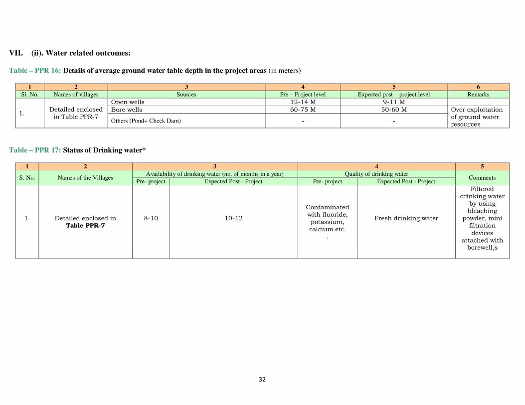
VII. (ii). Water related outcomes: Table – PPR 16: Details of average ground water table depth in the project areas (in meters)
1 2 3 4 5 6
Sl. No. Names of villages Sources Pre – Project level Expected post – project level Remarks
1. Detailed enclosed in Table PPR-7
Open wells 12-14 M 9-11 M
Bore wells 60-75 M 50-60 M Over exploitation of ground water resources
Others (Pond+ Check Dam) - -
Table – PPR 17: Status of Drinking water*
1 2 3 4 5
S. No. Names of the Villages Availability of drinking water (no. of months in a year) Quality of drinking water
Comments Pre- project Expected Post - Project Pre- project Expected Post - Project
1. Detailed enclosed in Table PPR-7
8-10 10-12
Contaminated with fluoride, potassium, calcium etc.
.
Fresh drinking water
Filtered drinking water by using bleaching
powder, mini filtration
devices attached with borewell,s

33
VII. (i). Expected employment related outcomes:
Table-PPR 18: Major crops grown and their productivity in the project area
1 2 3 4
S. No. Name of the Crop Current status Expected post project status
Area (ha.) Productivity (kg/ ha.) Area (ha.) Productivity (kg/ ha.)
Kharif Paddy
2400
2600
2700
3000
Rabi
Wheat Pulses
Vegetables
275 165
130
1400 900
250
310 185
150
1800 1050
300
Zaid / other season
Potato
150
275 200 320
34
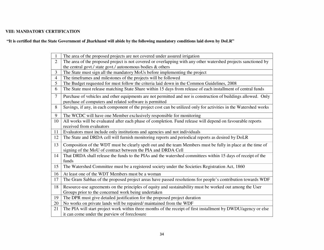
VIII: MANDATORY CERTIFICATION “It is certified that the State Government of Jharkhand will abide by the following mandatory conditions laid down by DoLR”
1 The area of the proposed projects are not covered under assured irrigation
2 The area of the proposed project is not covered or overlapping with any other watershed projects sanctioned by the central govt./ state govt./ autonomous bodies & others
3 The State must sign all the mandatory MoUs before implementing the project
4 The timeframes and milestones of the projects will be followed
5 The Budget requested for must follow the criteria laid down in the Common Guidelines, 2008
6 The State must release matching State Share within 15 days from release of each installment of central funds
7 Purchase of vehicles and other equipments are not permitted and nor is construction of buildings allowed. Only purchase of computers and related software is permitted
8 Savings, if any, in each component of the project cost can be utilized only for activities in the Watershed works
9 The WCDC will have one Member exclusively responsible for monitoring
10 All works will be evaluated after each phase of completion. Fund release will depend on favourable reports received from evaluators
11 Evaluators must include only institutions and agencies and not individuals
12 The State and DRDA cell will furnish monitoring reports and periodical reports as desired by DoLR
13 Composition of the WDT must be clearly spelt out and the team Members must be fully in place at the time of signing of the MoU of contract between the PIA and DRDA Cell
14 That DRDA shall release the funds to the PIAs and the watershed committees within 15 days of receipt of the funds
15 The Watershed Committee must be a registered society under the Societies Registration Act, 1860
16 At least one of the WDT Members must be a woman
17 The Gram Sabhas of the proposed project areas have passed resolutions for people’s contribution towards WDF
18 Resource-use agreements on the principles of equity and sustainability must be worked out among the User Groups prior to the concerned work being undertaken
19 The DPR must give detailed justification for the proposed project duration
20 No works on private lands will be repaired/ maintained from the WDF 21 The PIA will start project work within three months of the receipt of first installment by DWDU/agency or else
it can come under the purview of foreclosure

35
22 The State will not undertake unnecessary foreclosure of the projects. In the event of foreclosure, the State will refund the amount and furnish all necessary documents as desired by DoLR. The State shall also take administrative and legal action against any defalcation, misappropriation, mis-utilization, deliberate negligence and laxity which has caused foreclosure of the project.
Date:
Signature of officer authorized by State Govt.* NAME OF OFFICER (IN CAPITAL LETTERS)
DESIGNATION
36
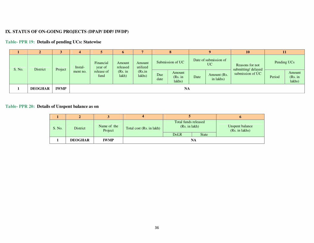
IX. STATUS OF ON-GOING PROJECTS (DPAP/ DDP/ IWDP) Table- PPR 19: Details of pending UCs: Statewise
1 2 3 4 5 6 7 8 9 10 11
S. No. District Project Instal-
ment no.
Financial year of
release of fund
Amount released (Rs. in lakh)
Amount utilized (Rs.in lakhs)
Submission of UC Date of submission of
UC Reasons for not submitting/ delayed submission of UC
Pending UCs
Due date
Amount (Rs. in lakhs)
Date Amount (Rs.
in lakhs) Period
Amount (Rs. in lakhs)
1 DEOGHAR IWMP NA
Table- PPR 20: Details of Unspent balance as on
1 2 3 4 5 6
S. No. District Name of the
Project Total cost (Rs. in lakh)
Total funds released (Rs. in lakh) Unspent balance
(Rs. in lakhs) DoLR State
1 DEOGHAR IWMP NA

37
X. ABSTRACT OF PROJECTS PROPOSED FOR SANCTION DURING FINANCIAL YEAR 2015-16
1 Number of districts to be covered under the present proposal
1
2 No. of Watersheds projects proposed to be taken up under NABARD
Hilly/Desert Others 2
3 Total area to be covered under proposed projects (in ha) (a) Hilly & Desert areas# (b) Others
Total
5741.9409
4 Area to be treated (in ha) 5111.5361
5 Total cost of the proposed Watershed projects (Rs. in lakhs)
(a) Hilly & Desert areas# (c) Others
Total
1022.3072 Lakhs
6 First installment required from central funds for the proposed watershed projects
204.4614 Lakhs