2 1. TOPIC2. Problem Statement3. OBJECTIVES4. METHDOLOGY5. WORK PLAN6. REFERENCES.
16
Transcript of 2 1. TOPIC2. Problem Statement3. OBJECTIVES4. METHDOLOGY5. WORK PLAN6. REFERENCES.


2

3

4

5
ZAIN
ZAIN

6
Remote sensing is a powerful technique for surveying, mapping and monitoring earth resources
The physico chemicals are the indicator of water quality, it is necessary to monitor quality with help of analytical tools
The quality of surface water is largely affected by anthropogenic inputs such as (municipal and industrial wastewater discharge).
,
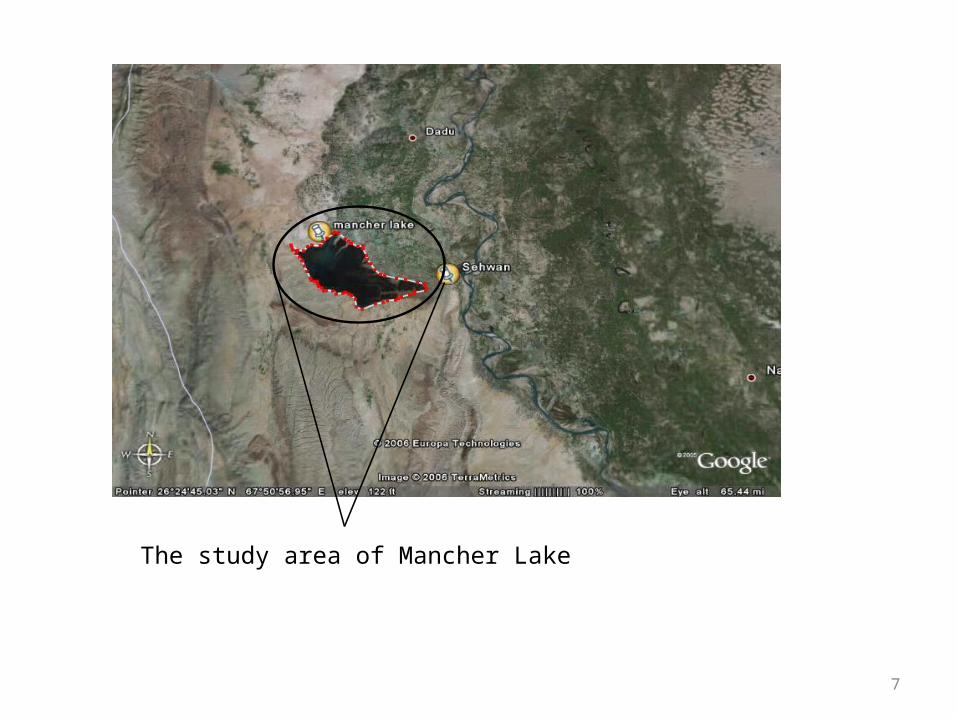
7
The study area of Mancher Lake

Topographic features of the lake
BoundaryNorth: agriculture land (Dadu) South: hills, dry land East: agriculture land Sehwan)West: hills, dry land

9

10
11
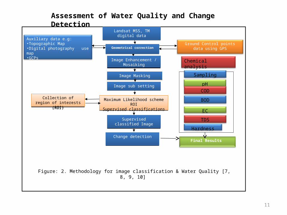
Landsat MSS, TM digital dataLandsat MSS, TM digital data
Ground Control points data using GPSGeometrical correctionGeometrical correction
Image Enhancement / Mosaiking
Image Enhancement / Mosaiking
Maximum Likelihood scheme ROISupervised classifications
Maximum Likelihood scheme ROISupervised classifications
Auxiliary data e.g:•Topographic Map•Digital photography use map•GCPs
Figure: 2. Methodology for image classification & Water Quality [7, 8, 9, 10]
Image sub settingImage sub setting
Image MaskingImage Masking
Collection of region of interests (ROI)
Collection of region of interests (ROI)
Supervised classified ImageSupervised classified Image
Change detectionChange detectionFinal Results
Chemical analysis
Sampling
pH
COD
BOD
EC
TDS
Hardness
Assessment of Water Quality and Change Detection

12
S NO. Activities Approximately 6 Months plan
1 2 3 4 5 6
1. Literature review Literature review
2. Survey of Mancher Lake
Survey of Mancher Lake
3. Results & Comparison
Results, Comparison, seminars
4. Thesis write up & Composition
Thesis write up, Composition & Final Seminar
13
[1] S. M. Enterprise Developed Authority, “Profile of District Dadu” Dec- 2002, PP. 24
[2]H.U. Abbasi., “Impact Assessment on Mancher Lake of Water Scarcity through Remote Sensing and Geographical Information System Based Study” M.Phil. Thesis, Centre for Environmental Sciences University of Sindh, Jamshoro, July 2007, PP. 54-56.
[3]Singh, A., Digital change detection techniques using remotely sensed data. International Journal of Remote Sensing, Volume 10(6), 1989, PP. 989–1003
[4]Mc Dermid, G.J. Franklin, S.E., and LeDrew, E.F. Remote sensing for large-area habitat mapping. Progress in Physical Geography 29 (4), 2005 PP. 449 – 474. 72.
[5]Richards J.A. and Jia Xiuping. “Remote Sensing Digital Image Analysis” Third edition, Springer Publishing, 1999 PP.189.
[6]
Abbasi, H., Baloch M.A., Memon. A.G., “deforestation analysis of riverine forest of Sindh using remote sensing techniques” Mehran university research journal of engineering & technology, Mehran university research journal of engineering & technology, volume 30, no. 3, July, 2011, PP. 477- 482 [ISSN 0254-7821].

14
[7]Mengxi Xu., “Assessment meth of lake water quality based on Remote sensed image and support vector machine” Second IEEE Conference on Industrial Electronics and Applications, 2007, PP. 2565-2570. UNESCO- IHE
[8]Lee, K.S., Joung, M.R, “determination of Land Use Change Categories Using Classification of Multitemporal Satellite Image Data”, GIS development, poster section 3, PP. 1-2, 1998 Korea,
[9]Xiwang Zhang, Fen Qin, Jianfeng Liu “Method of monitoring surface water quality based on remote sensing in Miyun reservoir” IEEE, PP 1-4, Jul 14, 2009
[10]Arain. M. B, Kazi. T. G, Jamali. M. K, Afridi. H. I, Baig. J. A, Jalbani. N, Shah. A. Q., “Evaluation of Physico-chemical Parameters of Manchar Lake Water and Their Comparison with Other Global Published Values” Pak. J. Anal. Environ. Chem. Vol. 9, No. 2 (2008) PP. 101 – 109, [ISSN-1996-918X]
[11]T. Wang., 2007. Monitoring of water quality for inland waters by remotesensing data. Xi’an University of Science and Technology.
[12]
S.J. Li., Q. Wu., X.J. Wang., X.Y. Piao., Y.N. Dai., 2002. CorrelationsBetween Reflectance Spectra and Contents of Chlorophyll-a in ChaohuLake. Journal of lake science. 14(3): 228-234.

15
[13]B. Zhang., B., Zhang., M. Hong., H.T. Duan., K.S. Song., Z.M. Wang.,2007. Advance in remote sensing of lake water quality. Advances in water science. 18(2),PP301-310.
[14]Y.P. Wang., Y.S. Min., J.M. Fu., G.Y. Sheng., 2001. Remote sensing Method of Water Pollution and Application on Water Pollution Monitoring in Guangzhou Section of Pearl River. Journal of remote sensing. 5(6):460-465.
[15]X.Q. Wang., Q.M. Wang., G.H. Liu., H.G. Li., 2002. Water pollution monitoring using remote sensing. Remote sensing technology and application. 17(2):74-78.
[16]S. Tassan., 1993. An improved in-water algorithm for the determination of chlorophyll and suspended sediment concentration from thematic mapper data in coastal waters. In J Remote Sensing. 14(6):1221-1229.
[17]C.Q. Chen., P. Shi., 2001. Study on modeling chlorophyll concentration of surface coastal water using TM data. Remote sensing of environment China. 11(3):168-176.

16

![ส่วนที่ 2file.siam2web.com/khumngern/files[document]/plan6/... · Web viewบทท 3 การว เคราะห ศ กยภาพของท องถ น 1.](https://static.fdocuments.net/doc/165x107/5e3f71170f63877e6b1882d9/aaaaaaa-2file-documentplan6-web-view-aaa-3-aaaa.jpg)


![2Aula plan6 ddd Geraldine.ppt [Modo de Compatibilidade] · Nome genérico do antimicrobiano Apresentação nº unidades Total (g) ... Cálculo do consumo de antimicrobiano • DDD](https://static.fdocuments.net/doc/165x107/5bfceb9d09d3f2bc6e8be720/2aula-plan6-ddd-modo-de-compatibilidade-nome-generico-do-antimicrobiano-apresentacao.jpg)