19 Environmental assessment of other issues
54
CBD Metro Environmental Assessment 413 CBD METRO ENVIRONMENTAL ASSESSMENT.DOC 19 Environmental assessment of other issues This chapter presents an assessment of the potential impacts of other non-key environmental issues during construction and operation of the project, and measures to mitigate these impacts. 19.1 Visual and urban design 19.1.1 Overview The design and appearance of the CBD Metro is of critical importance to Sydney Metro. Therefore, there would be stringent controls on the architectural and built form components of the project. The visual impact of the CBD Metro and how it integrates with existing (or future) land uses is an important social matter. The integration of the stations, their entry and exit points with the local built environment, would have an important influence on the character and social identity of areas surrounding the stations. This section provides a brief description of the main operational built elements, the particular visual sensitivities at each project site and the design principles that are being applied. The future end-state appearance of the above-ground and over-site elements of the CBD Metro is also considered in the master planning process, undertaken concurrently with the Environmental Assessment. The master planning strategy and principles are described in Chapter 17. As detailed within Chapter 13 and Technical Paper 5 Non-archaeological heritage, many of the station sites are characterised by historic streetscapes and buildings in view of the proposed station site locations. In all station sites other than Rozelle and Pyrmont, the loss of buildings as a result of demolition required for the station structures would generally be a neutral to slight positive impact due to the unsympathetic design of those buildings that make a negative contribution to the surrounding streetscape. However, at Rozelle and Pyrmont there would be loss of buildings that collectively contribute to the local heritage conservation areas. The loss of these buildings would result in moderately significant adverse impacts on the character of the local townscape and conservation area at these locations. The extent of this impact would be reduced by ensuring station entrance and ventilation structures of the replacement buildings are designed in context and consideration of the surrounding architecture, and the designs adhere to principles that enable integration, as far as practicable, with the relevant urban context. 19.1.2 Potential impacts Central Station The Central Station precinct is located at the southern end of the Sydney CBD. The visual character of this area is characterised by RailCorp’s heritage-listed Central Station terminal building, Belmore Park (particularly the large fig trees within the park), main traffic corridors such as George Street, Pitt Street and Broadway, and the mix of low- and medium-rise buildings.
Transcript of 19 Environmental assessment of other issues

CBD Metro Environmental Assessment
413
CBD METRO ENVIRONMENTAL ASSESSMENT.DOC
19 Environmental assessment of other issues
This chapter presents an assessment of the potential impacts of other non-key environmental issues during construction and operation of the project, and measures to mitigate these impacts.
19.1 Visual and urban design
19.1.1 Overview
The design and appearance of the CBD Metro is of critical importance to Sydney Metro. Therefore, there would be stringent controls on the architectural and built form components of the project.
The visual impact of the CBD Metro and how it integrates with existing (or future) land uses is an important social matter. The integration of the stations, their entry and exit points with the local built environment, would have an important influence on the character and social identity of areas surrounding the stations.
This section provides a brief description of the main operational built elements, the particular visual sensitivities at each project site and the design principles that are being applied.
The future end-state appearance of the above-ground and over-site elements of the CBD Metro is also considered in the master planning process, undertaken concurrently with the Environmental Assessment. The master planning strategy and principles are described in Chapter 17.
As detailed within Chapter 13 and Technical Paper 5 Non-archaeological heritage, many of the station sites are characterised by historic streetscapes and buildings in view of the proposed station site locations. In all station sites other than Rozelle and Pyrmont, the loss of buildings as a result of demolition required for the station structures would generally be a neutral to slight positive impact due to the unsympathetic design of those buildings that make a negative contribution to the surrounding streetscape.
However, at Rozelle and Pyrmont there would be loss of buildings that collectively contribute to the local heritage conservation areas. The loss of these buildings would result in moderately significant adverse impacts on the character of the local townscape and conservation area at these locations. The extent of this impact would be reduced by ensuring station entrance and ventilation structures of the replacement buildings are designed in context and consideration of the surrounding architecture, and the designs adhere to principles that enable integration, as far as practicable, with the relevant urban context.
19.1.2 Potential impacts
Central Station The Central Station precinct is located at the southern end of the Sydney CBD. The visual character of this area is characterised by RailCorp’s heritage-listed Central Station terminal building, Belmore Park (particularly the large fig trees within the park), main traffic corridors such as George Street, Pitt Street and Broadway, and the mix of low- and medium-rise buildings.

414 CBD Metro Environmental Assessment
CBD METRO ENVIRONMENTAL ASSESSMENT.DOC
The majority of streets within this location are identified as heritage streetscapes by the Sydney Local Environment Plan 2005 (Sydney LEP 2005). Important views include north/north-east views along George and Pitt streets towards the high-rise buildings at the CBD centre, and north-easterly views from Broadway of the Central Station terminal building, with its visually prominent clock tower.
The main proposed above-ground components at Central Station are outlined in Table 19.1.
Table 19.1 Central Station – main above-ground metro components
Component Description
Main entrance Railway Square
• The main entrance would be located below the existing western forecourt garden and would include lifts, escalators and ticketing. The core access to/from CityRail platforms (including the country platforms) would be via a new east-west tunnel below the existing Central Station terminal (subject to consultation with RailCorp).
Secondary entrances (staged)
• The secondary entrance would be located with access from Quay Street, corner of Pitt Street/Eddy Avenue and the Devonshire Street Tunnel and Henry Dean Place from Eddy and Pitt streets.
Services • Station services, such as ventilation and emergency egress, which would be integrated with the existing built form.
The design of the metro structures at this precinct considered the following factors:
• The main station entrance would be constructed adjacent to and within RailCorp’s heritage-listed Central Station terminal building and Central Railway Station group, and within clear view of a number of heritage-listed buildings along Pitt and George streets and Broadway.
• The majority of streetscapes within this precinct are heritage-listed (Sydney LEP 2005).
• The area is characterised by a mix of low- and medium-rise commercial buildings.
Accordingly, the following design principles have been used and would continue to guide future detailed design:
• Maintaining vistas towards Central Station from Railway Square and across Belmore Park.
• Reinforcing the edges of Railway Square by orienting entry to align with Lee Street.
• Minimising the impact of station services.
• Improving pedestrian amenity in Eddy Avenue and the Central Station western forecourt.
• Using materials and details that reflect the relationship to the heritage-listed Central Station.
• Creating a new station entrance within the existing station building on the corner of Pitt Street and Eddy Avenue.
Figure 19.1 shows an artist’s impression of the main Central Station entrance.

CBD Metro Environmental Assessment
415
CBD METRO ENVIRONMENTAL ASSESSMENT.DOC
Town Hall Square Station The Town Hall Square Station precinct is located within the midtown precinct of the Sydney CBD. The area is characterised by retail, commercial and residential buildings, heavily trafficked roads and footpaths, and key heritage buildings and prominent landmarks, including Sydney Town Hall, the Queen Victoria Building and St Andrews Cathedral. Building types range from low-rise buildings comprising only a few storeys, to a small number of towers taller than 100 metres.
Significant views include eastward views along Park and Bathurst streets towards Hyde Park and views towards or along George Street that include the prominent heritage buildings listed above, and northward views along Pitt Street to Centrepoint Tower.
Though densely developed, the midtown CBD precinct is undergoing redevelopment. Of particular significance is the City of Sydney proposal to develop a new civic square known as Town Hall Square, on the block bound by George, Pitt and Park streets. The main above-ground components of Town Hall Square Station are outlined in Table 19.2.

416 CBD Metro Environmental Assessment
CBD METRO ENVIRONMENTAL ASSESSMENT.DOC
Table 19.2 Town Hall Square Station – main above-ground metro components
Component Description
Main entrance South-west corner of Pitt and Park streets
• The main entrance would be housed in a station building that would include lifts, escalators, ticketing and station services such as ventilation shafts and emergency exits.
• Provision would be made for future development above the station (to be agreed with the City of Sydney Council).
• The station building would occupy less than half of the Park Street construction site; the remainder of the site is required to construct the station and would be temporarily leased from the City of Sydney Council. This site is earmarked for development by the City of Sydney Council into a civic square, known as Town Hall Square.
Secondary entrance Pitt Street, north-west corner of Pitt and Park streets
• The secondary entrance would be located within the Pitt Street footpath beneath the monorail station.
• The entrance would comprise only stairs and a lift.
Services building Bathurst Street
• The services building would house services such as an emergency exit and ventilation shafts.
• The services building would be designed to allow for future development above the building, in accordance with the City of Sydney Council controls.
The design of the metro structures considered the following factors:
• The number of heritage-listed buildings along Pitt Street in the vicinity of both entrances and the services building.
• The number of prominent landmarks surrounding the main entrance.
• The City of Sydney plan for Town Hall Square, once the main construction site is no longer required.
• The range of building heights within the area (ranging from about 20 metres to over 100 metres).
Accordingly, the following design principles have guided station design:
• Designing station buildings to reinforce the predominant street edges and building alignments.
• Providing active uses (such as retail) at the ground floor to enhance the attractiveness of street frontages.
• Minimising the impact of station services by locating services to the rear of the site.
• Using materials and details on the frontage to the square that reflect the relationship to Town Hall and the Queen Victoria Building.
• Ensuring transparency of the northern side of the main station entrance building to allow sightline to Town Hall from Hyde Park.
• Protecting the sightline from the new square to the Uniting Church on Pitt Street.
• Including public domain works, public art and landscaping to reinforce the Park Street alignment.
• Complying with relevant development controls.
Figure 19.2 is an artist’s impression of how Town Hall Square may look following implementation of the City of Sydney Council precinct vision, in addition to the metro station plans.

CBD Metro Environmental Assessment
417
CBD METRO ENVIRONMENTAL ASSESSMENT.DOC
Figure 19.3 shows an artist’s impression of the main entrance building, which reflects the design development to date. Consultation would continue with the City of Sydney Council to ensure that the metro station complex would be fully integrated into any future scheme for the proposed Town Hall Square. Realisation of Council’s vision for Town Hall Square would be a significant ancillary benefit of the project.

418 CBD Metro Environmental Assessment
CBD METRO ENVIRONMENTAL ASSESSMENT.DOC
Martin Place Station Martin Place is an open pedestrian plaza that slopes in an east-west direction from Macquarie Street down to George Street. Martin Place is lined by a number of heritage-listed buildings and the entire length of Martin Place is classified as a heritage streetscape (Sydney LEP 2005). The buildings are moderate in size, with a small number exceeding 100 metres in height.
Important visual elements within Martin Place include the Cenotaph and multiple entrances to CityRail’s Martin Place station. Other visual elements include trees along the plaza edges, small vendor facilities (e.g. florists), and street furniture such as scrolling advertisement boards, telephone boxes, some seating and information boards.
Between Hunter and Martin Place, Castlereagh Street is partially lined on both sides by trees and characterised by mostly tall commercial buildings. Between Martin Place and King Street the trees are predominantly on the western side of the street and the buildings are less dense and more varied in height. King Street, near Martin Place, is known as one of Sydney’s finest shopping streets and is regarded to be a streetscape of notably high visual quality.
The main above-ground components of Martin Place Station are outlined in Table 19.3.
Table 19.3 Martin Place Station – main above-ground metro components
Component Description
Main entrance Martin Place, west of Castlereagh Street
• The entrances would not be constructed within a building, but would comprise stairs down to the concourse, similar to the existing CityRail entrances.
• A lift would be provided within Martin Place near the entrance.
Services building Between Castlereagh and Elizabeth streets
• The services building would contain ventilation shafts, emergency exits and other station services.
• The services building would be designed to allow for future development above the building, in accordance with the City of Sydney’s Council controls.
Service facilities Castlereagh Street
• To allow for ventilation of the station, ventilation facilities would be required within the footpath or road reserve of Castlereagh Street.
The design of the metro structures considered the following factors:
• The unique open pedestrian plaza ‘style’ of Martin Place and the virtually uninterrupted views between Macquarie Street and George Street.
• The heritage values of Martin Place and surrounding heritage-listed buildings.
• The high visual quality of Castlereagh Street near Martin Place.
• The predominant building height.
Figure 19.4 provides a conceptual illustration of the entrance within Martin Place. The design of entrances and lift structures has sought to avoid the use of canopies over entrances, minimise bulk, cluttering and impacts to sightlines in Martin Place.

CBD Metro Environmental Assessment
419
CBD METRO ENVIRONMENTAL ASSESSMENT.DOC
The following design principles have been used and will continue to guide future detailed design:
• Minimising the number (where possible) of lifts within Martin Place while meeting accessibility objectives (only one lift at street level has been proposed).
• Designing and arranging the structures within Martin Place to reduce the visual impact.
• Designing services buildings to reinforce the predominant street edges and building alignments.
• Designing new buildings with regard to the setting of the adjoining buildings (e.g. by adopting a similar podium height.
• Providing active uses (such as retail) at the ground floor.
• Incorporating public art and/or advertising as part of ventilation structures.
• Complying with existing development controls.
Figure 19.5 provides a conceptual illustration of the vents on Castlereagh Street.

420 CBD Metro Environmental Assessment
CBD METRO ENVIRONMENTAL ASSESSMENT.DOC
Barangaroo-Wynyard Station The Barangaroo site is located between Darling Harbour and Sussex Street, at the north-western end of the Sydney CBD, and consists of over one kilometre of concrete wharves. There are relatively few structures on the site as most of the site is used for container storage. Prominent visual features surrounding the southern end of the Barangaroo site (the location proposed for the eastern station entrance) include the heritage-listed Moreton’s Hotel and the surrounding street trees, commercial office towers, and the Western Distributor overpass.
The visual character of the Wynyard area is characterised by medium-rise commercial buildings, including some heritage-listed buildings, surrounding Wynyard Park. Important views are available from the ridge at York Street towards Australia Square to the east and Darling Harbour and Barangaroo to the west.
The main above-ground components of the Barangaroo-Wynyard Station are outlined in Table 19.4.

CBD Metro Environmental Assessment
421
CBD METRO ENVIRONMENTAL ASSESSMENT.DOC
Table 19.4 Barangaroo-Wynyard Station – main above-ground metro components
Component Description
Western entrance Intersection of Sussex and Shelley streets, Barangaroo
• The eastern entrance building would be on the northern side of Shelley Street, comprising escalators and lifts. This entrance would be within the proposed Barangaroo development site.
• A services building would be provided south of Shelly Street to be incorporated within the future Barangaroo development.
Eastern entrance South-western corner of Clarence and Margaret streets
• The entrance building would include the main entrance on Clarence Street, lifts, escalators and station services.
• Provision would be made for future development to occur above the station building in accordance with City of Sydney’s development controls.
Barangaroo Pedestrian Link
• The pedestrian link would provide access between the Barangaroo waterfront (including the future ferry terminal) and the Barangaroo-Wynyard metro entrance, and then progress as a bridge (accessed via escalators and lifts) over Sussex Street into an extension of the adjacent Westpac Plaza.
• The bridge would be about 30 metres long, three metres wide and up to five metres high.
• The remainder of the Barangaroo Pedestrian Link would be contained within a subsurface tunnel.
The design of the metro structures considered the following factors:
• The proposed future development of the Barangaroo site.
• The character of the Wynyard area surrounding the eastern station entrance (such as heritage buildings, mostly medium rise buildings, and Wynyard Park).
An artist’s impression of the station entrance building at the corner of Clarence and Margaret streets is provided in Chapter 6 – Figure 6.45. The eastern entrance creates the opportunity to support ‘The City of Sydney Policy for the Management of Laneways in Central Sydney’ (City of Sydney 1999). It would create a renewed interest and vibrancy in York Lane by introducing increased activity and enhancing the diversity, vitality and economic vibrancy of this area.

422 CBD Metro Environmental Assessment
CBD METRO ENVIRONMENTAL ASSESSMENT.DOC
The following design principles have been used and would continue to guide future detailed design:
• Designing the services building at Barangaroo to reinforce the predominant street edges and building alignments and to address both street frontages.
• Designing the station entry building at Barangaroo with consideration of the existing development (such as Moreton’s Hotel) and the new development proposed at Barangaroo.
• Designing the station entry buildings at both sites to create a memorable and legible presence.
• Providing retail uses within the station buildings to enhance the attractiveness of street frontages.
• Minimising the impact of station services by locating services to the rear of the sites.
• Complying with relevant development controls.
• Designing the bridge associated with the Barangaroo Pedestrian Link to fit into the existing and future character of the area, with particular focus on the interface with Moreton’s Hotel and consistency with other planned bridges across Sussex Street and Hickson Road.

CBD Metro Environmental Assessment
423
CBD METRO ENVIRONMENTAL ASSESSMENT.DOC
Pyrmont Station The area of Pyrmont surrounding Union Square is characterised by low-rise development, public space and heritage buildings. Union Square is a paved and tree-lined public space, defined by a series of one- and two-storey sandstone heritage-listed buildings and containing an historic war memorial. Union Square is located within a heritage conservation area.
Significant views include the east-west view through Union Square and views from the eastern end of Union Square towards the CBD. Other prominent visual elements include the tree-lined Union Street, which connects Union Square to Pyrmont Street, north-south views along the tree-lined Harris Street, and the heritage buildings along Miller Street, at the intersection with Harris Street.
The main above-ground components of Pyrmont Station are outlined in Table 19.5.
Table 19.5 Pyrmont Station – main above-ground metro components
Component Description
Eastern entrance Corner of Union and Pyrmont streets
• The station building would have an eastern entrance onto Union Street, with escalators, a lift and station services.
• Provision would be made for retail uses to occupy the area of the site fronting Pyrmont Street.
• No further development above the station building is proposed.
Western entrance Corner of Miller and Mount streets
• The station building would have a western entrance onto Miller Street, with escalators, lifts and station services.
• Provision would be made for retail uses to occupy the area of the site fronting Mount and/or Miller streets.
• No further development above the station building is proposed.
The design of the metro structures considered the following factors:
• The values of the heritage conservation area and contributing heritage buildings adjacent to both station entrances.
• The vibrant nature of Union Square as a prominent public space within Pyrmont.
• The existing low-rise buildings.
The following design principles have been used and will continue to guide future detailed design:
• Considering retaining the existing buildings or building facades.
• Designing station buildings to actively contribute to the streetscape of Union Square.
• Designing station buildings to reinforce the predominant street edges and building alignments.
• Applying appropriate heritage guidelines to the design in the context of the conservation zone.
• Providing retail uses within the station buildings to enhance the attractiveness of street frontages.
• Minimising the impact of station services by locating services to the rear of the sites.
• Maintaining the sightline through Union Square.
• Repaving Union Street to be consistent with Union Square.

424 CBD Metro Environmental Assessment
CBD METRO ENVIRONMENTAL ASSESSMENT.DOC
• Selecting materials and detailing to respond to the masonry character of Union Street and Union Square.
• Complying with existing development controls.
Figure 19.7 is an artist’s impression of the western station entrance building at the corner of Mount and Miller streets. Artist’s impressions of the eastern station entrance building at the corner of Union and Pyrmont streets are shown in Chapter 6 Figure 6.46 (Alternative 1) and Figure 6.47 (Alternative 2).
Rozelle Station The inner west suburb of Rozelle is bisected by Victoria Road, a major arterial road and retail strip. The street is characterised by up to eight lanes of traffic (including turning lanes) and two-storey retail and mixed-use buildings, and is located within a heritage conservation area. Heritage-listed church buildings are located on either side of Darling Street near the intersection with Victoria Road, but views to these buildings from Victoria Road are currently blocked from view by retail buildings at the corner of the intersection.
The intersection of Darling Street and Victoria Road is located at the top of a ridge, providing significant views to the north-west towards Drummoyne and to the south-east towards the CBD. The main above-ground components of Rozelle Station are outlined in Table 19.6.

CBD Metro Environmental Assessment
425
CBD METRO ENVIRONMENTAL ASSESSMENT.DOC
Table 19.6 Rozelle Station – main above-ground metro components
Component Description
Main entrance Western corner of the Victoria Road and Darling Street intersection
• The station building would include entrances from Victoria Road and Darling Street, lifts, escalators and services.
• Two levels of retail space with frontage onto Darling Street would be provided within the station building.
Secondary entrances Northern and eastern corners of the intersection
• The station entrance buildings would include lifts and escalators. • Retail kiosks would be incorporated in each station entrance.
Bus facilities • Bus stops would be located on Victoria Road inbound (to the CBD). • Bus bays would be located on Victoria Road outbound (from the CBD).
Artist’s impressions of the Rozelle Station entrances are shown in Figure 19.8 and Figure 19.9.

426 CBD Metro Environmental Assessment
CBD METRO ENVIRONMENTAL ASSESSMENT.DOC
The design of the metro structures considered the following factors:
• The proximity of heritage buildings and the values of the heritage conservation area.
• Existing visual limitations, such as restricted views to the heritage-listed church buildings.
• The ‘high street’ appearance of Rozelle (that is two-storey retail and mixed-use buildings).
Accordingly, the following design principles have been used and will continue to guide future detailed design:
• Designing the station entrance buildings to relate to the scale and consistency of adjacent buildings.
• Designing the main station entrance building to reinforce the predominant street edges.
• Designing pavilion-style entries with small station plazas on the eastern side of Victoria Road to open up views to the church and school buildings, but with adequate enclosure to provide visual (and noise) buffering from Victoria Road.
• Providing a small retail/café space at the northern entries to activate the forecourt spaces.
• Minimising the impact of station services by locating services to the rear of the sites.
• Complying with existing development controls.
Rozelle stabling and maintenance depot The Rozelle stabling and maintenance depot site is situated adjacent to major transport infrastructure, foreshore, public open spaces, housing and light industry. The visual character of the site is characterised by the existing rail infrastructure of the former Rozelle Marshalling Yard, commercial and industrial warehouses, and low-rise and densely spaced residential development. There are important local views to the CBD and Rozelle Bay from some elevated locations to the north-west of the site. Residential views to the former Rozelle Marshalling Yard are fully or partially screened at most locations by vegetation and/or commercial buildings on the edge of the site.

CBD Metro Environmental Assessment
427
CBD METRO ENVIRONMENTAL ASSESSMENT.DOC
The main above-ground components of the Rozelle stabling and maintenance depot are outlined in Table 19.7.
Table 19.7 Rozelle stabling and maintenance depot – main above-ground metro components
Component Description
Stabling area • New tracks, over access gantries, and tunnel portals.
Buildings • Rolling stock maintenance building. • Infrastructure maintenance facility. • Administration building. • Wheel lathe facility. • Wash plant. • The buildings would all be about 10 metres high, except for the
administration building, which would be about two-storeys high.
Pedestrian and cyclist bridge
• A pedestrian and cyclist bridge would be constructed over the depot from Lilyfield Road to White Bay.
Retaining walls • Retaining walls would be located along the boundary with Lilyfield Road and a small section of the boundary with City West Link.
Fencing • 2.4-metre painted steel palisade fencing is proposed for the majority of the site.
• A two-metre high masonry wall is proposed along the property boundary at the portal location.
Other elements • Substations. • New roads. • Landscaping.
Lighting • General lighting of access roads and paths. • Lighting of rolling stock stabling areas. • External lighting of buildings for both access and security. • Security lighting of access gates to the depot. • General lighting of the vehicle parking areas. • General area lighting of the maintenance areas to allow for traffic and
activities during maintenance hours. • General security lighting.
The design of the metro structures considered the following factors:
• Adjacent residential development
• Existing and future views
• The potential for light spill.
428 CBD Metro Environmental Assessment
CBD METRO ENVIRONMENTAL ASSESSMENT.DOC
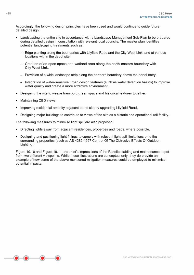
Accordingly, the following design principles have been used and would continue to guide future detailed design:
• Landscaping the entire site in accordance with a Landscape Management Sub-Plan to be prepared during detailed design in consultation with relevant local councils. The master plan identifies potential landscaping treatments such as:
− Edge planting along the boundaries with Lilyfield Road and the City West Link, and at various locations within the depot site.
− Creation of an open space and wetland area along the north-eastern boundary with City West Link.
− Provision of a wide landscape strip along the northern boundary above the portal entry.
− Integration of water-sensitive urban design features (such as water detention basins) to improve water quality and create a more attractive environment.
• Designing the site to weave transport, green space and historical features together.
• Maintaining CBD views.
• Improving residential amenity adjacent to the site by upgrading Lilyfield Road.
• Designing major buildings to contribute to views of the site as a historic and operational rail facility.
The following measures to minimise light spill are also proposed:
• Directing lights away from adjacent residences, properties and roads, where possible.
• Designing and positioning light fittings to comply with relevant light spill limitations onto the surrounding properties (such as AS 4282-1997 Control Of The Obtrusive Effects Of Outdoor Lighting).
Figure 19.10 and Figure 19.11 are artist’s impressions of the Rozelle stabling and maintenance depot from two different viewpoints. While these illustrations are conceptual only, they do provide an example of how some of the above-mentioned mitigation measures could be employed to minimise potential impacts.

CBD Metro Environmental Assessment
429
CBD METRO ENVIRONMENTAL ASSESSMENT.DOC

430 CBD Metro Environmental Assessment
CBD METRO ENVIRONMENTAL ASSESSMENT.DOC
Construction impacts During construction, the visual integrity and character of areas would be affected by the visual impact of vacant sites (as a result of demolition) and construction sites. This could negatively impact, in particular, the social identity and character of spaces such as Union Square, the Darling Street/ Victoria Road intersection at Rozelle, Rozelle Darling Street intersection, Martin Place civic space, and Central Station western forecourt.
Visual impacts would also occur from temporary road works and/or traffic diversions, acoustic sheds over sites, construction worker sheds and compounds, plant equipment and other machinery, particularly for conservation areas or locations closely connected to heritage items.
The construction works would occur at each of the sites for at least 12 months. In many instances, they would continue for the entire five-year construction period, resulting in a medium-term temporary deterioration in the visual amenity within the precincts around the construction sites.
Construction hoardings and scaffolding would be the most pronounced visual change. These are likely to range between three to six metres in height and represent the visual character for many people with views to the construction sites, be they workers or residents.
19.1.3 Mitigation and management
Operation A Design Review Panel would be established to evaluate the detailed design of stations and associated precinct works with particular focus on at-surface design. The Design Review Panel would comprise independent specialist expertise in architecture, urban design, transport, heritage and sustainability.
At all stations (and Rozelle stabling and maintenance depot), design principles to create safe, legible and attractive spaces would be applied. This would include application of Crime Prevention Through Environmental Design (CPTED) principles.
Construction Visual intrusion of construction sites on nearby residents and users of local facilities and amenities would be contained and limited as far as reasonably practicable. The contractor would ensure that, where appropriate, construction activities are screened to minimise impacts on heritage conservation areas and the amenity value of recreational/civic spaces.
Storage sites, fixed plant and machinery equipment and temporary offices would be located to limit visual impacts, as far as reasonably practicable, and would have due regard to neighbouring accommodation, as far as allowed by the constraints of each site.
The type of hoarding or fencing used would vary from location to location but would accord with council policy – namely, the Hoardings and Scaffolding (Local Approvals Policy) (City of Sydney Council 2009) for City of Sydney LGA, and the appropriate codes of Leichhardt Municipal Council.
General principles applying to hoarding or fencing would include:
• The standard hoarding would be a minimum 2.4-metre high, plywood-faced, timber-framed hoarding, suitably painted.
• The hoarding would be increased in height and possibly altered in form to enhance acoustic performance for specific locations.
• A 1.8-metre high chain-link fence may be used at more remote, less visually prominent locations.
CBD Metro Environmental Assessment
431
CBD METRO ENVIRONMENTAL ASSESSMENT.DOC
• Suitable measures would be used for tree protection.
• Where reasonably practicable, existing walls and fences would be retained.
• Notices would be displayed on all site boundaries, where appropriate, to warn of on-site hazards such as deep excavations and construction access.
• Appropriate sight lines/visibility splays would be maintained to ensure the safety of both vehicles and pedestrians.
• Temporary fences may be used in certain areas, such as for short-term occupation of sites or at more remote locations.
• Hoardings, construction fencing or other barriers would be carefully located so as to not hinder the visibility of business frontages.
A ‘good housekeeping’ policy would be promoted and enforced on all the construction sites to ensure that clean, tidy and safe sites are provided.
The construction lighting would be designed to comply with the provisions of AS 4282-1997 Control Of The Obtrusive Effects Of Outdoor Lighting, where applicable. Lighting around construction work sites would be specifically designed, positioned and directed so as not to unnecessarily intrude on adjacent buildings and to reduce light spill to nearby residents, or constitute a road, shipping or rail hazard, while still meeting public and worker safety requirements and maintaining visibility.
In addition, security cameras would be sited and directed so that they would not intrude into occupied residential properties.
19.2 Air quality
19.2.1 Overview
Existing air quality The existing air quality in the inner city CBD areas is typical of developed residential and commercial areas with the local air quality influenced by emissions from major arterial roads and other pollutants such as dust, pollen and bushfires in the Sydney basin. There are limited industrial sources that contribute to pollutant mix in the project area. Air pollutants which are potentially harmful to human health including carbon monoxide (CO), ozone (O3) nitrogen oxides (NOx), sulfur dioxide (SO2) and total suspended particles (TSP) (including PM10 – particles less than 10 micrometres in diameter) are present within the airshed. The principal source of these pollutants is road traffic, with maximum concentrations occurring near busy roads.
The Department of Environment, Climate Change and Water (DECCW) monitors air quality at various locations across NSW. There are two DECCW air monitoring stations located in the vicinity of the CBD Metro – Randwick (Randwick Barracks) and Rozelle (Rozelle Hospital). These stations are considered to be partially indicative of the air quality within the study area. The results of the air monitoring data for the key pollutants since year 2000 at Randwick and Rozelle are shown in Table 19.8. There were no recorded results for carbon monoxide at Randwick Barracks and none for sulfur dioxide at Rozelle Hospital.
Air quality assessment criteria have been obtained from Approved Methods for the Modelling and Assessment of Air Pollutants in New South Wales (DEC 2005). Generally, the results at these monitoring stations were below the DECCW air quality goals with no exceedances for NO2, SO2 or CO. There were exceedances for ozone maximum one-hour average value during three of the years at Randwick and during 2001 at Rozelle, all of which were above the 10 parts per hundred million

432 CBD Metro Environmental Assessment
CBD METRO ENVIRONMENTAL ASSESSMENT.DOC
(pphm) air quality goal. There were also three exceedances of the PM10 24-hour average value of 50 micrograms per cubic metre (µg/m³) at Rozelle and a notably high record for Randwick during 2007 (due to bushfires). Air quality at Rozelle may be impacted by the vehicular traffic flows along Victoria Road, which may have caused a consistent exceedance of the PM10 goals.
Table 19.8 Summary of Randwick and Rozelle air quality monitoring data (2000 to 2008)
SO2 (pphm) NO2 (pphm) O3 (pphm) PM10 (µg/m³) CO (ppm)
Randwick Rozelle Randwick Rozelle Randwick Rozelle Randwick Rozelle Randwick Rozelle
Year Maximum 1-hour average
Maximum 1-hour average
Maximum 1-hour average
24-hour average Maximum 8-hour average
DECCW Goal
20 12 10 50 9
2000 2.7 - 6.6 7.0 8.7 8.0 - - - 4.5
2001 3.6 - 6.5 6.6 11.4 11.5 - - - 3.2
2002 2.4 - 5.4 8.6 13.9 10.0 - - - 2.8
2003 3.5 - 5.5 5.2 7.9 8.3 - - 2.2
2004 2.4 - 5.7 6.4 11.0 9.4 - 54.1 - 2.2
2005 2.5 - 6.3 5.2 9.6 8.1 - 46.8 - 2.1
2006 4.3 - 6.0 5.7 8.3 9.3 - 50.3 - 2.0
2007 3.6 - 4.5 5.0 9.0 8.8 71.2 54.4 - 1.8
2008 2.9 - 4.1 4.0 6.1 5.6 36.3 43.1 - 1.3
Source: Department of Environment and Climate Change Data from Air Quality Index (Randwick and Rozelle) www.environment.nsw.gov.au
Sydney CBD air quality data were also sourced from the Cross City Tunnel project air quality monitoring as detailed in Table 19.9. According to this data, there have been no exceedances of the DECCW goals at the Cross City Tunnel project air quality monitoring station at Mary Ann Street Park, Ultimo since 2004 (CrossCity Motorway Ltd 2008).
Table 19.9 Local air quality at Ultimo monitoring station
Pollutant DECCW Goal 2004/05 2005/06 2006/07 2007/08
Carbon monoxide (CO average ppm)
9 ppm 1.9 1.3 1.7 1.2
Nitrogen dioxide (NO2 average pphm)
12 pphm 5.2 4.7 4.4 4.0
Total nitrogen oxides (NOx average pphm)
No standard 25.3 19.6 20.6 19.2
Particulate matter (PM10 average µg/m3)
50 µg/m3 37.1 35.4 36.6 29.1
Particulate matter (PM2.5 average µg/ m3)
25 µg/m3 5.1 14.0 15.3 11.1
Source: Ground level Ambient Air Quality Monitoring Results (Mary Ann Street Park, Ultimo). Cross City Tunnel Air Quality Monitoring Reports. 2005/06 figures based on Sep 05 to May 06 monthly averages. www.crosscity.com.au
CBD Metro Environmental Assessment
433
CBD METRO ENVIRONMENTAL ASSESSMENT.DOC
Data in Table 19.9 indicate a general improvement in air quality consistent with the DECCW’s findings reported in its Action for Air 2006 Update (DEC 2006a). The data summarised in the above tables suggest that while there are exceedances for the DECCW air quality goals within the CBD area, these are not a common occurrence and, overall, the air quality of the project areas is relatively good.
The pollutants of most concern during the construction and operation of the CBD Metro project are PM10 and deposited dust. Potential pollutants from construction vehicles include TSP, NOx and SO2.
The DECCW assessment criteria are a maximum increase in annual deposited dust of 2 g/m2 per month above the background levels, and guidelines stipulate that maximum total dust deposited from any source should be no more than 4 g/m2 per month over a 12-month period. The PM10 24-hour limit assessment criteria is 50 µg/m³ and an annual limit of 30 µg/m³ (DEC 2005).
19.2.2 Potential impacts
Construction The main potential air quality impacts during construction would be temporary impacts associated with dust. The major sources of dust during construction would be from excavation works, demolition of existing buildings and erosion of exposed surfaces and spoil piles. The amount of dust generated from excavation works would be dependent on the particle size and moisture content of the soils, the types of activities carried out during construction, prevailing weather conditions and the area of exposed surfaces. There is a risk of significant impacts of nuisance dust if dust control measures are not put in place.
As most of the CBD Metro would be constructed in tunnel, the main dust impacts would primarily be confined to the above-ground station and depot construction sites and the major tunnel access site at White Bay, as described below.
At the construction site required for the Rozelle stabling and maintenance depot at the former Rozelle Marshalling Yard, there would be significant earthworks, which would pose a high risk of potential dust impacts. A suite of mitigation measures would be undertaken at this site to ensure dust deposition resulting from construction would not result in excessive impacts.
White Bay would be a major construction site used for launching the TBM and for removing excavated material from tunnels.
Some spoil would also need to be removed from each of the station construction sites.
Removal of spoil has the potential to create significant amounts of dust. In total, about 1.27 million cubic metres (solid not bulked) of spoil would be excavated and stockpiled and/or transported from work sites, most of it via the road network. Windy conditions may increase the dispersal rates of dust from stockpiles and exposed areas. Dust may also be tracked onto footpaths and roads from the construction sites.
The demolition of buildings also has the potential to result in significant amounts of dust, including from hazardous biological material, such as bird droppings. Particulate and dust impacts from surface sites have the potential to affect the amenity for residences and businesses near construction sites.
Other air pollutants would also be emitted by:
• Construction plant and machinery. The TBMs and roadheaders use electric power and therefore do not create exhaust emissions at the locality. However, at some stages of the project, TBMs, roadheaders and other plant may operate using diesel generators.

434 CBD Metro Environmental Assessment
CBD METRO ENVIRONMENTAL ASSESSMENT.DOC
• Construction vehicles. Large amounts of construction traffic would be generated by the construction of the CBD Metro, with associated gaseous and particulate pollutants from vehicles and plant emitted into the Sydney region air shed. Although they are unlikely to be sufficient to cause significant impacts from air pollution to the region, localised impacts, particularly at construction sites, may result.
Operation Once the CBD Metro is operating, air quality impacts would include be minor, and would include:
• Minor particulate matter generated by train operations and passenger movements. Brake dust would be produced at locations where trains would be required to slow down or stop. These emissions are anticipated to be minor, as trains would use regenerative braking, which would reduce the potential for generation of particulates, and station platforms would be partitioned by platform screen doors from the main tunnels.
• Possible minor changes to local air quality near the Rozelle stabling and maintenance depot, which is already likely to be dominated by emissions from the City West Link. The stabling yard would be used for train and infrastructure maintenance. The use of diesel-powered plant, equipment and vehicles would result in minor release of exhaust emissions into the environment.
The tunnel ventilation system, which would prevent the build-up of hot air in the tunnel, would not be likely to have impacts on air quality. It would draw fresh air through the entrance of the tunnel, pass it through the tunnel, and discharge it through ventilation shafts into the surrounding outdoor air. The ventilation shafts would be used to adjust the rate of air flow through the tunnels, and ensure air from the tunnels is well dispersed and diluted into the outdoor air, so there would be only negligible impacts on local air quality. A ventilation system, consisting nominally of four ventilation fans at each station, would also be provided at each station.
This ventilation system would also respond to emergency conditions such as fire incidents where smoke-laden air would be discharged through the emergency ventilation system to prevent smoke from entering stations or recirculating through the ventilation shafts or tunnel portals.
Road network modelling indicates that there would be minimal change in vehicle kilometres travelled (vkt) attributable to the CBD Metro. However, the CBD Metro project would be consistent with protecting and improving air quality across the Sydney Basin by supporting the recognised need to curb growth in transport emissions while maximising transport choice.
19.2.3 Mitigation and management
Construction A Construction Air Quality Management Sub-Plan would be prepared in accordance with the Construction Environmental Management Plan (CEMP). This Sub-Plan would include, but not be limited to, the mitigation measures listed below.
Vehicle and plant emissions Measures to control and limit vehicle and plant emissions and avoid nuisance would include the following, as appropriate and as far as reasonably practicable:
• Ensuring that the engines of all vehicles and plant on site are not left running unnecessarily.
• Using low emission vehicles and plant fitted with catalysts, diesel particulate filters or similar devices.
• Using ultra-low sulfur fuels in plant and vehicles.

CBD Metro Environmental Assessment
435
CBD METRO ENVIRONMENTAL ASSESSMENT.DOC
• Requiring that plant would be well maintained and serviced to reduce emissions due to poor engine performance.
• Siting haul routes and operate plant (including generators) away from sensitive receivers such as dwellings and schools.
Dust control strategy The Environmental Construction Method Statements (ECMSs), prepared as part of the CEMP, would include dust management plans for each work site to limit dust emissions. The dust management plans would use a risk-based approach to identify construction sites with potential to generate significant quantities of dust near sensitive receptors and which require additional levels of control. The minimum procedure to be employed on any site with a low risk of dust emissions would include site controls to:
• Install hard surface on long-term haul routes, which are regularly damped down with fixed or mobile sprinkler systems and regularly cleaned. Hard-standing sites would contribute significantly to reducing potential dust (and also sedimentation) impacts.
• Ensure no burning of waste materials takes place on main construction sites.
• Provide and ensure the use of wheel-wash facilities near the site exit, where practical, and implement a street-cleaning regime to remove any dirt tracked onto roads.
• Ensure that unsurfaced haul routes and work areas are regularly damped down in dry and windy conditions.
• Use dust suppression measures to control the dust dispersal during windy conditions.
• Impose and signpost site speed limits on haul routes to minimise dust creation.
• Ensure all vehicles carrying loose or potentially dusty material to or from the site are fully covered.
• Ensure bulk cement and other bulk fine powder materials are stored in silos with suitable emission control systems to prevent escape of material and overfilling during delivery.
• Ensure materials with potential source of dust are enclosed or in a shielded location.
• Minimise the amount of excavated material held on site.
• Minimise areas of exposed earth by staging construction activities.
• Sheet, seal or damp down stockpiles of excavated material held on site, where required.
• Ensure water suppression is used during demolition operations.
• Use enclosed rubble chutes and conveyors where reasonably practicable, and minimise drop heights from conveyors, loading shovels, hoppers and other loading or handing equipment and/or use water to suppress dust emissions from such equipment.
• Only use cutting, grinding or sawing equipment fitted or in conjunction with suitable dust suppression techniques such as water sprays or local extraction.
• Undertake proactive monitoring to ensure that dust deposition resulting from construction does not result in excessive dust generation.
For the stockpile and spoil sites, especially those at the major construction site at White Bay, stockpiles would need to be strategically located and adequately protected from the elements.
436 CBD Metro Environmental Assessment
CBD METRO ENVIRONMENTAL ASSESSMENT.DOC
Dust generation from the transfer of spoil from skips to the storage bins would be prevented by depositing spoil within the confines of the vertical enclosures of the bin or hoppers and using water jet sprays for dry spoil. Where feasible, recycled water would be used for dust suppression in advance of potable water.
Dust extraction and filtration systems would be installed at White Bay for the tunnel excavation works and at all sites where tunnelling and deep excavation with limited surface exposure is undertaken to ensure air quality levels are below relevant operational health and safety requirements for workers.
Additional controls for specific sites or phases on construction deemed to be high-risk would include:
• Strip insides of buildings, as far as reasonably practicable, before demolition.
• Bag and remove biological debris (such as bird nests and droppings) or damp down such material prior to demolition.
• Conduct an asbestos survey in buildings to be demolished by a suitably qualified person, and manage and dispose of any asbestos found in accordance with the Code of Practice for the Safe Removal of Asbestos (National Occupational Health and Safety Committee 2002 [1988]) and Australian Standard AS-2601 1991 – Demolition of Structures.
• Screen buildings, where dust-producing activities are taking place, with debris screens or sheeting.
• Where appropriate, raise the height of hoardings to protect receptors.
• Consider full enclosure of sites or specific operations where there is a high potential for dust production and the site is active for an extensive period.
Operation During operation of the metro:
• A ventilation system would be provided in the CBD Metro tunnel and in each station to ensure air is well dispersed and diluted to the outdoor air.
• Station partitions would be provided to separate the main tunnel from the station platforms. Regenerative brakes would also be installed on the trains.
• Plant, equipment and vehicles used for maintenance activities would not be left running or idling when not in use so as to cause impairment to local air quality.
• Plant would be fitted with appropriate emission controls and would undergo periodic and regular maintenance to reduce exhaust emissions.
19.3 Ecology
19.3.1 Overview
Study area The study area for the ecology assessment comprises the proposed surface construction areas including the Rozelle stabling and maintenance depot and the White Bay and Belmore Park construction sites.
This area consists entirely of modified land previously cleared of all remnant vegetation. Some native and non-indigenous vegetation is present, particularly at Belmore Park, and there are landscaped

CBD Metro Environmental Assessment
437
CBD METRO ENVIRONMENTAL ASSESSMENT.DOC
gardens at the former Rozelle Marshalling Yard. In contrast, the White Bay site and the majority of the Rozelle stabling and maintenance depot site are colonised by exotic flora, suited to the disturbed and modified landscape. Natural top soils at both sites have been replaced by introduced fill and compacted base materials from the former industrial use, thus creating an altered micro-environment unsuitable for re-growth of indigenous vegetation.
Data review A background review was conducted to identify potential target species (refer Technical Paper 7 Ecology). It found that 53 threatened flora species, 35 threatened fauna species and a number of Endangered Ecological Communities (EECs) listed under the Threatened Species Conservation Act 1995 (TSC Act) and Environmental Protection and Biodiversity Conservation Act 1999 (EPBC Act) have been recorded in the vicinity of the study area.
Site surveys An inspection and survey of the study area was conducted during March 2009 to identify the extent and quality of any flora and fauna species present, and the potential for threatened species or EECs in the study areas of Belmore Park, White Bay and the proposed Rozelle stabling and maintenance depot site.
Belmore Park is a heavily used urban park and is landscaped with planted trees and lawn. Mature trees consist of London Plane (Platanus hispanica), Cabbage Palm (Livistona australis), Brush Box (Lophostemon confertus), Morton Bay Fig (Ficus macrophylla) and Port Jackson Fig (Ficus rubiginosa) and a number of exotic shrubs in the central and western gardens. Chewed figs observed beneath each Morton Bay Fig suggests the trees are a food source for the Grey-headed Flying-fox (Pteropus poliocephalus), listed as Vulnerable under the TSC Act and EPBC Act. This species is known to forage in the area, and maintains a seasonal roosting camp in the nearby Royal Botanic Gardens. Five mature and two juvenile Morton Bay Figs were present in Belmore Park. No other trees were considered likely to provide foraging resources. The introduced Rock Dove (Columba livia), native Silver Gull (Larus novaehollandiae) and Australian White Ibis (Threskiornis molucca) were observed in the study area. These bird species are adapted to urban environments and are recognised as pests when existing in concentrated areas such as parks.
The proposed Rozelle stabling and maintenance depot and White Bay sites contain completely modified landscapes consisting of formerly cleared land and occupied by industrial or transport infrastructure. No natural habitats or remnant vegetation is present. The flora is dominated by exotic species and a range of weed species comprising mainly Blackberry (Rubus fruticosus), Lantana (Lantana camara), Bamboo (Phyllostachys aurea) and various exotic grasses and groundcovers. Fauna habitats have been completely modified consisting of construction rubble and decommissioned rail infrastructure with some fringing exotic vegetation. The absence of surface water (ponds or creeks) suggests that there is no potential habitat for aquatic species such as the Green and Golden Bell Frog (Litoria aurea), which is listed as endangered under both the EPBC Act and TSC Act.
A partially open subterranean tunnel used for cabling at the proposed Rozelle stabling and maintenance depot revealed a large and partly flooded tunnel during observations. This could provide a potential roosting habitat for microchiropteran bat species (referred to as microbats). A number of bat species roost in caves or artificial structures that substitute for this habitat type in urban areas. The Eastern Bent-wing Bat (Miniopterus schreibersii oceanensis), listed as Vulnerable under the TSC Act, has been recorded in several local government areas in Sydney and is known to roost in drains and tunnels.
As a result, additional targeted surveys were conducted to confirm the presence or absence of this bat species. This consisted of observations of the tunnel entrance (from sunset to one hour after dark for two evenings in March) and placement of an audio bat detector (Anabat unit) at the tunnel entrance to record any calls from emerging bats. Using Anabat units enables the species of the bats to be

438 CBD Metro Environmental Assessment
CBD METRO ENVIRONMENTAL ASSESSMENT.DOC
identified through analysis of the call frequency. The records detected no bats from within the tunnel. Therefore, the tunnel is considered unlikely to be currently used as a roost site.
During these surveys a Grey-headed Flying-fox was observed foraging in the fruit trees within a residence to the north-west of the site. Other than the Grey-headed Flying-fox, no other threatened flora and fauna species were identified from the site surveys. The study area is considered highly unlikely to provide potential habitat for listed flora species due to the highly altered state of these sites. The use of the study area by threatened fauna, apart from the Grey-headed Flying-fox, would be restricted to possible foraging activities by insectivorous and urban dwelling bats such as the Eastern Bent-wing Bat (M.schreibersii), which has adapted to foraging in urban areas within Sydney.
19.3.2 Potential impacts
Construction The lack of native flora and fauna, vegetation and habitats in the study area reflects the extent of modification of these urban landscapes. In particular, the White Bay and Rozelle stabling and maintenance depot sites provide little to no habitat value for native flora and fauna having been completely modified in terms of resource availability. No listed EECs are represented in the study area and there was no evidence of listed species and communities and unique or significant conservation values for listed flora and fauna in the study area.
During construction, there would be potential for direct impacts on the terrestrial ecology of the White Bay, Belmore Park and Rozelle stabling and maintenance depot construction sites. Any minor disturbances to flora and fauna would be localised and limited to the construction period.
At Belmore Park, potential direct impacts include the removal of a few planted trees and at least one mature Morton Bay Fig tree (planted as part of the original scheme in 1900). The removal of the trees would remove potential roosting and foraging habitat for urban bird populations. The proposed removal of Morton Bay Fig trees would result in the loss of a portion of seasonal food sources for Grey-headed Flying-fox populations. However, sufficient food resources, including large numbers of fig trees, are widely available and distributed throughout the locality such that the project is not considered to be a significant impact on the population.
Construction works at the sites would also potentially impact the possible foraging activities of insectivorous and urban-dwelling listed bats such as the Eastern Bent-wing Bat. However, this species has adapted to foraging in urban areas in Sydney, and the study area does not present unique characteristics to attract the species to the locality. The project is not considered to pose a significant impact on threatened insectivorous bats, as no building structure likely to be habitable for bat would be demolished as part of the project.
Operation There would be no impacts on flora and fauna during operation of the CBD Metro as the project would largely be located underground.
19.3.3 Mitigation and management
The overall impacts on vegetation would be minimal. However, the following mitigation measures would be implemented:
• Construction site works at Belmore Park would restrict vegetation clearance wherever possible, particularly the removal of large fig trees. Lopping and direct avoidance would be used to protect trees wherever possible, and preferred over total removal of trees, where applicable.

CBD Metro Environmental Assessment
439
CBD METRO ENVIRONMENTAL ASSESSMENT.DOC
• The location of large, mature trees would be considered for equipment storage areas and worksites so that the boundary is sufficiently distanced from the drip zones of trees. The limits of clearing would be documented in the Environment Construction Method Statements (ECMS) and Environmental Control Maps and clearly marked with temporary fencing prior to clearing on site.
• Where a tree’s presence is problematic, smaller and more manoeuvrable equipment would be considered to protect trees and minimise disturbance. Smaller equipment would be available during all stages of construction and used in all areas where a minimised disturbance area is required to preserve trees adjacent to the construction site.
• Consideration would be given to planting mature fig trees as an additional food resource in any nearby landscaping proposed or in any site rehabilitation required at Belmore Park and/or Rozelle and White Bay. This would be beneficial for the Grey-headed Flying-fox.
• Weed management would be undertaken during construction in accordance with the Noxious Weeds Act 1993 to prevent re-establishment or further spread of weeds. Weeds would be removed from the construction site prior to the commencement of works. Weeds would be placed in sealed bags and disposed of at an appropriately licensed waste disposal facility.
• A Landscape Management Sub-Plan would be prepared in consultation with relevant local councils. The plan would cover such issues as tree protection measures, monitoring during construction, replanting and post-construction monitoring.
• Approval from Sydney Metro would be required by the construction contractor prior to the removal of any individual trees within or adjacent to construction sites. Consultation with the relevant local council would be undertaken where relevant.
19.4 Indigenous heritage
19.4.1 Overview
Traditional ownership and evidence of occupation The traditional owners of the project area are the Wangal and Cadigal people of the Dharug (Eora) language group. The land of the Cadigal people stretches from South Head to Petersham (City of Sydney Council 2009) and the land of the Wangal people originally extended from the suburbs of Balmain and Birchgrove in the east, to Silverwater and Auburn in the west (Leichhardt Municipal Council 2009).
As part of the project communications program, a written request to identify any indigenous heritage constraints to the project was sent to the Metropolitan Local Aboriginal Land Council (Metropolitan LALC). Site inspections of the areas affected by surface works were undertaken at the start of August accompanied by members of the Metropolitan LALC. Following this inspection notification was received by Sydney Metro that the surveyed area contained no Aboriginal cultural material, sites or relics and that the Metropolitan LALC has no objections or concerns with the CBD Metro project.
The urbanisation of the Sydney CBD areas, including the Rozelle peninsula, has ensured that the landscape and its vegetation has been significantly altered and no longer resembles the pre-European contact landscape. Typical items or evidence of indigenous occupation within the Sydney Basin and foreshore areas include isolated finds, open artefact scatters or camp sites, middens, rock shelters containing surface artefacts and/or rock art, and tool-grinding-groove sites. The project area has been heavily disturbed by intensive urban development, which would have severely impacted indigenous sites in this area.

440 CBD Metro Environmental Assessment
CBD METRO ENVIRONMENTAL ASSESSMENT.DOC
The foreshore area in the vicinity of Barangaroo-Wynyard Station, formerly known as East Darling Harbour, was formed about 6,000 years ago. There is evidence of shell middens and rock engravings close to Barangaroo-Wynyard Station, which signify extensive occupation by the indigenous people (SHFA 2007). The shell middens are characteristic of the fishing, hunting and shellfish-gathering activities of the Cadigal people. The population of the indigenous people declined after the arrival of the First Fleet, although occupation of the area continued until the 20th Century. Archaeological excavations of Millers Point in 1980 (located about 800 metres north from Barangaroo-Wynyard Station), found a campsite including a large shell midden and stone tools, which were excavated from beneath the development (SHFA 2007).
Recent heritage assessments A detailed heritage assessment of the Sydney CityGrid Project comprising substations and a tunnel network for power distribution cables in the Sydney CBD was undertaken in May 2008 (Energy Australia 2008). Parts of the proposed network are located in the vicinity of the Barangaroo-Wynyard Station and Martin Place Station. The assessment concluded that there was a low to negligible potential for indigenous sites to be present in areas impacted by the Sydney CityGrid Project.
In addition, the Archaeological Management Plan for the Rocks and Millers Point by the Department of Public Works and Services, as identified in the Barangaroo Environmental Assessment (SHFA 2007), considered the East Darling Harbour site as ‘mostly and partially disturbed’ in regard to its archaeological potential.
Data review for the CBD Metro project Due to the fact that the potential of discovering unknown indigenous sites is likely to be low, the assessment of indigenous heritage has consisted of a review of existing background documentation sources, including recent archaeological reports from the project area and heritage registers that record indigenous information.
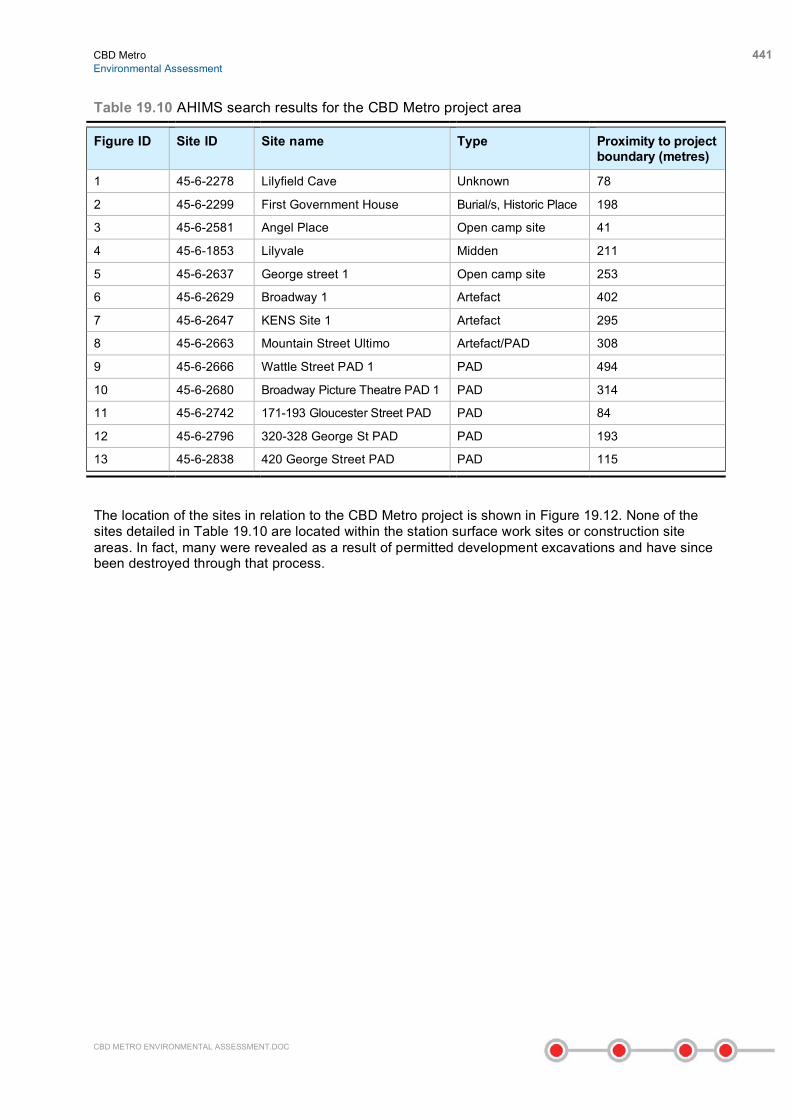
A search of the Department of Environment, Climate Change and Water (DECCW) Aboriginal Heritage Information Management System (AHIMS), the State Heritage Register and Inventory, the Register of the National Estate and the National Trust Register, was undertaken for the proposed surface work sites, the former Rozelle Marshalling Yard, each of the proposed station sites and areas potentially required for ancillary activities.
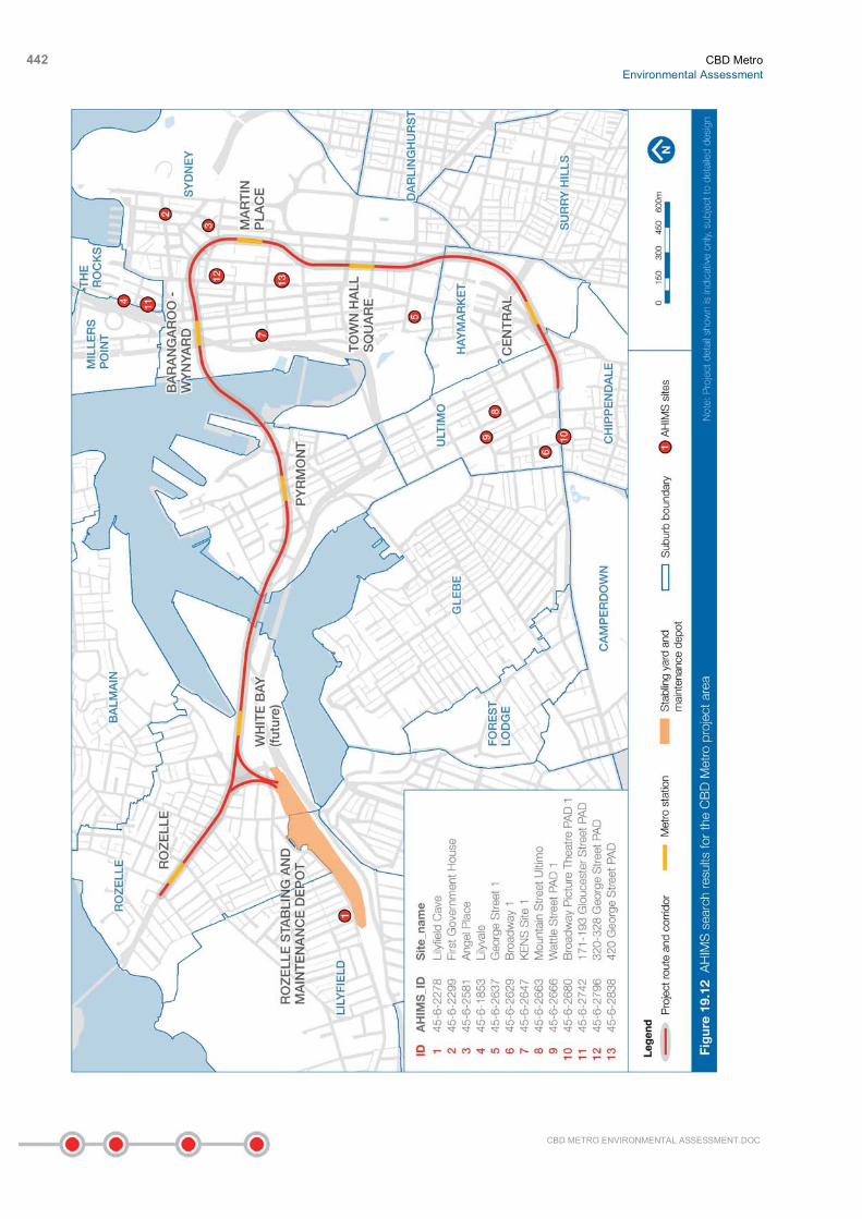
The AHIMS search (500 metres from alignment centreline) identified 13 indigenous objects and sites as occurring within this search area. The objects/sites found include middens, burials, open camp sites, potential archaeological deposits (PADs) and artefacts. The results of the search are provided in Table 19.10.
CBD Metro Environmental Assessment
441
CBD METRO ENVIRONMENTAL ASSESSMENT.DOC
Table 19.10 AHIMS search results for the CBD Metro project area
Figure ID Site ID Site name Type Proximity to project boundary (metres)
1 45-6-2278 Lilyfield Cave Unknown 78
2 45-6-2299 First Government House Burial/s, Historic Place 198
3 45-6-2581 Angel Place Open camp site 41
4 45-6-1853 Lilyvale Midden 211
5 45-6-2637 George street 1 Open camp site 253
6 45-6-2629 Broadway 1 Artefact 402
7 45-6-2647 KENS Site 1 Artefact 295
8 45-6-2663 Mountain Street Ultimo Artefact/PAD 308
9 45-6-2666 Wattle Street PAD 1 PAD 494
10 45-6-2680 Broadway Picture Theatre PAD 1 PAD 314
11 45-6-2742 171-193 Gloucester Street PAD PAD 84
12 45-6-2796 320-328 George St PAD PAD 193
13 45-6-2838 420 George Street PAD PAD 115
The location of the sites in relation to the CBD Metro project is shown in Figure 19.12. None of the sites detailed in Table 19.10 are located within the station surface work sites or construction site areas. In fact, many were revealed as a result of permitted development excavations and have since been destroyed through that process.
442 CBD Metro Environmental Assessment
CBD METRO ENVIRONMENTAL ASSESSMENT.DOC

CBD Metro Environmental Assessment
443
CBD METRO ENVIRONMENTAL ASSESSMENT.DOC
However, the detection of 13 indigenous sites demonstrates that indigenous objects and sites may still survive, even in the highly modified environment of the CBD. This is shown by the uncovering of artefacts at the following recent excavations:
• In the excavation at Angel Place in 1997, 54 indigenous artefacts were recovered from the remnant topsoils below the earliest historical levels on site. The range of artefact types suggests that the site was originally a complex site of occupation along the Tank Stream (AHMS 2007).
• The ‘Lilyvale midden’ was uncovered during building works on the corner of Cumberland and Essex Streets, The Rocks, near the historic ‘Lilyvale’ building. However, this midden was highly disturbed by the construction of terrace houses in the 1830s and was subsequently destroyed by the construction of a hotel sometime after (Comber Consultants 2008).
• An archaeological assessment was undertaken at a development site bound by Kent, Erskine, Napoleon and Sussex Streets (hence known as the KENS site). During excavations, 952 artefacts were retrieved. The occupation of the site was estimated between 2,800 before present (BP) to 1788 (Comber Consultants 2008).
• There are three known burials at First Government House (AHIMS Site No 45-6-2299), including Arabanoo, captured by Governor Phillip in late 1788, who was buried in the Government House gardens (Crook et al 2003). A number of indigenous artefacts including flaked or possibly flaked stone and glass artefacts were retrieved during excavation (Crook et al 2003).
19.4.2 Potential impacts
No known indigenous items or sites are anticipated to be directly or indirectly affected by the project. This is because:
• The majority of the CBD Metro tunnelling would be at a depth of at least 20 metres through bedrock where archaeological deposits are not expected to be found.
• The main risk to any remaining indigenous heritage would be the construction of the station sites and ground disturbance at surface work sites. The particular areas have been heavily modified on the surface and at depth, through successive construction and reconstruction activities associated with the development of the Sydney CBD. The potential for disturbance to any intact items or places of indigenous heritage significance at any station site or construction area is considered to be minor.
• As shown in Table 19.10, none of the AHIMS-listed items are located within the project boundary. These sites would not be impacted by the CBD Metro project. In addition, a number of previously identified indigenous items have been destroyed or salvaged as part of previous development works. They include Angel Place (AHIMS Site No 45-6-2581), Lilyvale (AHIMS Site No 45-6-1853) and KENS Site 1 (AHIMS Site No 45-6-2647). No information could be found with regard to the site ‘Lilyfield Cave’ (Site No 45-6-2278) and the potential for this site to still exist intact. However, the site is located north of Lilyfield Road, so would be sufficiently distant from the project area for the project to have no potential of impact.
Nevertheless, the original shoreline has been extended seaward using extensive fill in the vicinity of the Barangaroo-Wynyard Station construction site, and this area has some potential to contain evidence of indigenous occupation beneath the areas previously filled. Therefore, all excavations on the project and in the Barangaroo-Wynyard Station construction site, in particular around the area of the former shoreline and in the vicinity of lower Margaret Street for the Barangaroo-Wynyard Station, could potentially affect any associated foreshore deposits containing archaeological material. Measures would be implemented to manage the discovery of unknown or previously unidentified heritage items during the works (see below).
444 CBD Metro Environmental Assessment
CBD METRO ENVIRONMENTAL ASSESSMENT.DOC
19.4.3 Mitigation and management
Prior to the commencement of construction works, all personnel working on site would be trained about their responsibilities under the National Parks and Wildlife Act 1974 and the procedure in the event an indigenous item is discovered. The pre-construction induction would advise all employees and/or contractors engaged in the CBD Metro project construction works that it is an offence under the National Parks and Wildlife Act 1974 to knowingly disturb or destroy indigenous relics.
If previously unrecorded items or sites of indigenous heritage significance were uncovered during the construction phase, work would immediately cease in the vicinity of those sites. The uncovered site would be reported immediately to the Cultural Heritage Branch of DECCW and advice sought from an appropriately qualified indigenous heritage consultant concerning the appropriate course of action. The Metropolitan LALC would also be informed at the time of DECCW notification. Work in the affected areas would not resume until any required approvals have been received.
19.5 Geology and groundwater
19.5.1 Overview
Geotechnical investigations Information about the geotechnical conditions of the study area were derived from:
• The findings of recent projects. Many CBD buildings have basements that have been excavated deep into the ground, and numerous tunnels have been excavated under the CBD including the RailCorp tunnels, electricity and stormwater tunnels, and the Cross City and Eastern Distributor road tunnels.
• Boreholes drilled for the CBD Metro project investigations. About 60 boreholes were drilled along the seven-kilometre proposed route alignment (including the Rozelle stabling and maintenance depot), to a maximum depth of 60 metres. Five of the boreholes were made over water – two in Darling Harbour and three in Johnstons Bay from a specialised jack-up barge.
A range of geotechnical information was gathered from the boreholes, known geotechnical conditions and intended uses of the site, including:
• Rock core samples extracted and stored (all boreholes).
• Survey of borehole locations (all boreholes).
• In-situ water pressure (packer permeability) testing (all boreholes).
• In-situ stress testing (six boreholes).
• Optical imaging of the borehole wall (all boreholes).
• Groundwater level monitoring (16 boreholes).
• Contamination and/or groundwater aggressivity testing (selected locations).
• Various laboratory tests on selected rock and overburden (soil/fill) samples.
The geotechnical studies completed for basement and tunnel projects and the data obtained from the boreholes have been used to inform a model of geotechnical conditions along the project alignment.

CBD Metro Environmental Assessment
445
CBD METRO ENVIRONMENTAL ASSESSMENT.DOC
Geology The study corridor traverses two main stormwater catchments of the CBD and Rozelle areas, and a third area of White Bay and Pyrmont, which are relatively low in elevation. The highest topographical point is at Darling Street, Rozelle, at 42.1 metres Australian Height Datum (AHD), and the lowest point is at Pirrama Road, Pyrmont, at 0.5 metres AHD. In the CBD area the highest point is at York Street, Wynyard, at 26.5 metres AHD with the lowest point adjacent at Shelly Street, Barangaroo, at 2.5 metres AHD. Notable changes in topography include a gentle incline between Central and Town Hall, a more prominent slope from Wynyard down to Darling Harbour and a moderate upwards slope from White Bay to Rozelle.
The CBD Metro alignment traverses the upper sedimentary rock formations of the Sydney Basin. The bedrock stratigraphic sequence includes Hawkesbury Sandstone that is overlain by the Wianamatta Group (including Ashfield Shale and Mittagong Formation). The proposed tunnel, station caverns and associated shafts would be generally located within the Hawkesbury sandstone. At White Bay, areas of man-made fill underlay the White Bay construction site and the Rozelle stabling and maintenance depot. A thin capping of Ashfield Shale and Mittagong Formation is present within the regions of Central Station and Town Hall Station.
A schematic long-section indicating the generalised geology of the tunnel route is shown in Figure 19.13.
Other geological characteristics of the areas traversed by the CBD Metro tunnel corridor and station locations include:
• Four linear fault zones, which have been identified along the project corridor (Pells et al 2004). The fault zones and the associated rock jointing result in a reduction in rock mass strength, increased rock permeability and, at times, higher groundwater levels.
• Dykes, which exist within the vicinity of the project corridor. Studies indicate that the alignment may intersect up to seven dykes.
• Based on Geoscience Australia's Earthquake Database, Sydney’s CBD is located in a relatively benign seismic zone. As such, although earthquake loading has been considered as part of the CBD Metro design, it is not likely to be a significant determinant of the tunnel design.
• Channel features and inclusions of siltstone and shale within the Hawkesbury Sandstone.
• The Darling Harbour and Johnstons Bay crossings include paleo-channels within the Hawkesbury Sandstone that have subsequently become buried within the estuarine sediments and filling of these areas of the harbour.

446 CBD Metro Environmental Assessment
CBD METRO ENVIRONMENTAL ASSESSMENT.DOC
Groundwater A number of minor streams and tributaries historically led to the major water bodies in the study area. These drainage features, which originally contained alluvial deposits, are now substantially formalised within drainage systems and have been buried or excavated by subsequent development.
Perched water tables are commonly reported within the Ashfield Shale strata and within the surficial soils overlying the general bedrock strata. Major geological structures such as fault zones and dykes may provide conduits or partial barriers to groundwater flow.
The quality of groundwater in the Sydney basin is generally high in iron (ranging from 40–110 milligrams per litre), may contain manganese and other contaminants, with relatively high total dissolved salts (TDS) and a low pH. Ashfield Shale was deposited in a marine environment and groundwater leaching through this environment is generally of higher salinity. Closer to major tidal water bodies, saline groundwater is expected to be present within the alluvium and fill. Saline groundwater may also have permeated into groundwater bodies within the Hawkesbury Sandstone. Groundwater quality may also be affected by past development activities. Investigations undertaken as part of the Barangaroo development identified groundwater with elevated hydrocarbons and other contaminants. At the former Rozelle Marshalling Yard, hydrocarbons may be present in groundwater due to previous industrial activity at the site.
In general, these waters need treatment to reduce iron content to less than one milligram per litre prior to discharge to receiving waters. Proposed methods to manage groundwater inflows are addressed in section 19.5.3.

CBD Metro Environmental Assessment
447
CBD METRO ENVIRONMENTAL ASSESSMENT.DOC

448 CBD Metro Environmental Assessment
CBD METRO ENVIRONMENTAL ASSESSMENT.DOC

CBD Metro Environmental Assessment
449
CBD METRO ENVIRONMENTAL ASSESSMENT.DOC
19.5.2 Potential impacts
The majority of the CBD Metro corridor is underlain by Ashfield Shale of the Wianamatta Group and Hawkesbury (Sydney) Sandstone. The rock is overlain by limited thicknesses of residual soil, with some areas of alluvium near the water crossings and man-made fill. These conditions are favourable for the excavation of tunnels using conventional techniques.
A number of components of the project have the potential to cause ground settlement as a result of construction and associated activities. Ground movement may occur as a result of the process of tunnel excavation and associated dewatering of adjacent aquifers. Ground movement can result in damage to land and property.
It is anticipated that the majority of the settlement induced along the alignment due to tunnel construction would be a result of stress redistribution within the rock mass. A single-pass segmental lined tunnelling process would be used, which means that movement would be limited as much as possible. The construction of fully tanked tunnels would limit anticipated groundwater drawdown to negligible levels. While ground settlement would be small and unlikely to cause major distress to existing nearby surfaces and underground structures along the route, appropriate design requirements and safeguards, to avoid impacting on structures along the route, would still be required.
The project would be designed and constructed in a manner that would minimise the damage to land and property as a result of ground movement. Previous tunnelling projects within Hawkesbury Sandstone in the Sydney Region have demonstrated that construction can occur with minimal long-term impact on existing structures and the ground surface. Techniques for controlling settlement of buildings and protecting buildings from irreparable damage are well developed, based on other tunnelling projects within Sydney. It is anticipated that the CBD Metro permanent tunnel support would be largely designed as passive support, with the ground deflecting until the support takes up the load. Station caverns may require additional support structures such as rock anchors and rock bolting.
The project may limit, to a small extent, future land use within the metro corridor, as any future land development above the corridor would need to consider the depth and structural integrity of the sub-surface tunnels. For example, if load stresses experienced by the tunnel are likely to change as a result of a new development, that development proposal would need to consider how it would protect the integrity of the tunnel structure. The protection regime for future land use within the metro corridor and the potential for the project to limit future land use are discussed in further detail in Chapter 17.
19.5.3 Mitigation and management
Management and mitigation measures to reduce the risk of landform instability and settlement would be adopted during the design and construction phases of the project. These would include:
• A Geotechnical and Settlement Management Strategy, which would be prepared and implemented to ensure that geotechnical conditions are modelled and the likely effects of any groundwater drawdown is considered as part of the detailed design development process. This strategy would include a process for ensuring that full details of existing and approved excavations, basements, tunnels and other sub-surface structures are identified.
• A detailed geotechnical model for the route and its surroundings, which would be developed and progressively updated during design and construction. This model would identify and include significant geological structures. It would include full details of basements and other sub-surface structures that may be impacted by the project. The model would be used to:
− Assess the predicted settlement and horizontal strain profiles caused by tunnelling.
− Assess the impact of these predicted settlements and strains on buildings and basements.
450 CBD Metro Environmental Assessment
CBD METRO ENVIRONMENTAL ASSESSMENT.DOC
• Condition surveys of buildings and structures in the vicinity of the tunnel and station cavern excavations.
• Settlement criteria for individual sensitive utility structures, including RailCorp tunnels and the Cross City Tunnel, brick sewers, gas, electricity and telecommunication services. These would be determined in consultation with the relevant authorities and owners prior to the commencement of tunnelling in the vicinity of these structures.
• Incorporating reasonable and feasible management measures to minimise potential ground settlement – should the geotechnical model indicate that exceedance of the settlement criteria are likely – into design and construction instructions. These would be implemented accordingly.
• Monitoring of groundwater levels and ground settlement. Monitoring locations and durations would be determined from the detailed geotechnical model.
• All practicable measures would be implemented to ensure that operational groundwater inflows for station caverns and crossovers are limited to between 6.5 and 11 litres per day per square metre, subject to ground conditions. This water would be collected, treated and then sent into the utility system. The main tunnels would be designed to be watertight, so no water ingress is expected.
19.6 Energy use and greenhouse gas
19.6.1 Overview
Energy is an important consideration for the CBD Metro as a large amount of energy would be required to construct and operate the project. It is estimated that energy use during the construction phase would be primarily from:
• Electricity to power the TBMs, roadheaders, and tunnel ventilation.
• Fuel (diesel and petrol) to power construction plant and vehicles.
• Fuel to transport construction materials, waste and recyclables to and from sites.
Energy use during operation of the CBD Metro would be primarily from:
• Electricity to power the metro trains (traction).
• Electricity to power the metro infrastructure (tunnel ventilation, lifts, escalators and lighting).
• Electricity to power the operations of the Rozelle stabling and maintenance depot (maintenance plant, cleaning plant and lighting).
• Fuel (diesel, petrol and biodiesel) to power depot plant equipment and maintenance vehicles.
As the majority of electricity in NSW is currently produced from ‘black’ coal, electricity use would be a main contributor to greenhouse gas emissions from the project. Fuel use would also emit greenhouse gases as these produce about 2.3 to 2.7 kilograms of carbon dioxide equivalent (CO2-e) emissions per litre of fuel consumed (DEWHA 2008). In addition, indirect and third party emissions would be generated as a result of energy used to produce materials (for example steel and concrete) – which is known as ‘embodied energy’.
The increase of greenhouse gases in the atmosphere, in particular anthropogenic carbon dioxide (that is, caused by humans), has contributed to enhanced global warming and climate change.

CBD Metro Environmental Assessment
451
CBD METRO ENVIRONMENTAL ASSESSMENT.DOC
Opportunities to minimise energy use, maximise efficiency and therefore reduce the whole-of-life financial and environmental costs of the CBD Metro are identified below.
19.6.2 Potential impacts
Construction Energy consumption (including fuel and electrical power) and the associated greenhouse gas emissions predicted during the five-year construction period are presented in Table 19.11. As shown, about 50 per cent of the energy required would be used to construct the tunnels (including White Bay Station).
The estimates of greenhouse gas emissions during construction are based directly on the estimated energy requirements for the project. The greenhouse gas emissions are reported in tonnes of carbon dioxide equivalent (CO2-e). Carbon dioxide equivalent is a measure used to standardise the global warming potential of different greenhouse gases to that of carbon, the most common greenhouse gas.
The greenhouse gas emissions were also reported in two ways:
• Direct emissions refer to those emissions produced directly from the consumption of electricity and fuel at the site.
• Full fuel cycle emissions is a measurement that takes into account both the direct emissions and the indirect emissions associated with extraction, production and transportation of fuels in the energy generation lifecycle.
Table 19.11 Energy consumption and associated emissions over the construction period
Energy consumption GWh 2
Emissions ktCO2-e 3
Construction component1
Electricity Diesel Direct Full fuel cycle
Caverns – surface plant 76 0.0 60 70
Caverns – shaft plant 15 0.0 12 14
Cavern – plant 64 0.0 50 59
Cavern – lining 4 11 6 34
Tunnel – surface plant 33 0.0 26 31
Tunnel – plant 126 0.0 99 116
Total 318 11 253 324
1 Compared to the station construction sites, where significant excavations would be required, the Rozelle stabling and maintenance depot would require much less energy to construct and is therefore not considered further in this assessment. 2 GWh: Gigawatt hours. Equivalent to 1 billion watts 3 ktCO2-e: 1,000 tonnes of carbon dioxide equivalent
Based on these calculations, the construction of the project would generate about 324 kilo tonnes of carbon dioxide equivalent (CO2-e) greenhouse gas emissions (full fuel cycle). Electricity used in construction, particularly tunnelling, would comprise the main percentage of these emissions.
Greenhouse gases would also be released during the production of materials for the project, most significantly for steel and concrete. It is estimated that the project would use about 323,000 cubic metres of concrete and 32,000 tonnes of steel. In recent times there have been a number of developments to improve the environmental performance of concrete. For the concrete mix for the
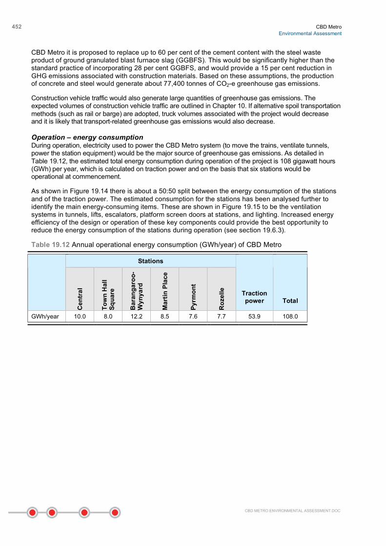
452 CBD Metro Environmental Assessment
CBD METRO ENVIRONMENTAL ASSESSMENT.DOC
CBD Metro it is proposed to replace up to 60 per cent of the cement content with the steel waste product of ground granulated blast furnace slag (GGBFS). This would be significantly higher than the standard practice of incorporating 28 per cent GGBFS, and would provide a 15 per cent reduction in GHG emissions associated with construction materials. Based on these assumptions, the production of concrete and steel would generate about 77,400 tonnes of CO2-e greenhouse gas emissions.
Construction vehicle traffic would also generate large quantities of greenhouse gas emissions. The expected volumes of construction vehicle traffic are outlined in Chapter 10. If alternative spoil transportation methods (such as rail or barge) are adopted, truck volumes associated with the project would decrease and it is likely that transport-related greenhouse gas emissions would also decrease.
Operation – energy consumption During operation, electricity used to power the CBD Metro system (to move the trains, ventilate tunnels, power the station equipment) would be the major source of greenhouse gas emissions. As detailed in Table 19.12, the estimated total energy consumption during operation of the project is 108 gigawatt hours (GWh) per year, which is calculated on traction power and on the basis that six stations would be operational at commencement.
As shown in Figure 19.14 there is about a 50:50 split between the energy consumption of the stations and of the traction power. The estimated consumption for the stations has been analysed further to identify the main energy-consuming items. These are shown in Figure 19.15 to be the ventilation systems in tunnels, lifts, escalators, platform screen doors at stations, and lighting. Increased energy efficiency of the design or operation of these key components could provide the best opportunity to reduce the energy consumption of the stations during operation (see section 19.6.3).
Table 19.12 Annual operational energy consumption (GWh/year) of CBD Metro
Stations
Cen
tral
Tow
n H
all
Squa
re
Bar
anga
roo-
Wyn
yard
Mar
tin P
lace
Pyrm
ont
Roz
elle
Traction power Total
GWh/year 10.0 8.0 12.2 8.5 7.6 7.7 53.9 108.0

CBD Metro Environmental Assessment
453
CBD METRO ENVIRONMENTAL ASSESSMENT.DOC
Operation – greenhouse gas emissions Impact of government policies As discussed in section 19.6.1, greenhouse gas emissions are often related directly to energy consumption (assuming a base case of conventional grid-supplied energy). It is expected that emissions from the metro system would decline over time as the greenhouse gas emissions from Australia’s electricity generation changes significantly with changes in the proportional mix of electricity generation technologies (as renewable energy power plants are developed). Government policies such as the Carbon Pollution Reduction Scheme (CPRS) and the Renewable Energy Target (RET) are expected to provide impetus to this change.
The CPRS is a cap and trade emission trading scheme that will cover the majority of emissions across all sectors. Under the CPRS, an emission cap will be set to achieve the Australian Government emission reduction targets to 2020 and 2050. The design of the CPRS is such that the polluters

454 CBD Metro Environmental Assessment
CBD METRO ENVIRONMENTAL ASSESSMENT.DOC
(energy generators, fuel retailers and industrial process emitters) will be required to surrender energy permits at the end of each year equal to their carbon emissions reported that year. A finite number of total permits will be available for purchase through auctions throughout the year. For the purposes of this assessment, it is assumed that the CPRS would reduce greenhouse gas emissions by 15 per cent of 2000 levels by 2020 and 60 per cent by 2050.
The Australian Government has also recognised that the CPRS requires complementary policies to incentivise renewable energy generation, otherwise renewable energy, as a carbon reduction initiative, will not represent least-cost abatement at the commencement of the CPRS. To address this, the Australian Government is proposing to increase the current mandatory Renewable Energy Target (RET) of two per cent of Australia’s electricity from renewables by 2010 with an RET of 20 per cent by 2020. The enabling legislation for the RET is currently in draft form and has yet to be passed through the Senate, but COAG agreement has been reached (COAG 2009) and the legislation will potentially be passed this year.
Based on the estimated total energy use requirements detailed in Table 19.12, actual amounts of greenhouse gas emissions resulting from the operation of the project have been calculated based on five scenarios. The first two scenarios are based on the absence or presence of the CPRS and RET and are defined as:
• Scenario 1 – no CPRS or RET in place. This scenario does acknowledge that there would be a slight reduction in the emission intensity of grid electricity even without the CPRS or RET schemes in place.
• Scenario 2 – influence of CPRS and RET. This scenario assumes that the CPRS reduces greenhouse gas emissions by 15 per cent of 2000 levels by 2020 and 60 per cent by 2050, and that the RET of 20 per cent renewables is in place by 2020.
The results of the scenarios are presented in Table 19.13 and in Figure 19.16. The comparison of these scenarios demonstrates the degree to which emissions reductions for the project would be driven by implementation of other government strategies. In 2050, the expected annual operational emissions for the project would be about 94.1 kilo tonnes of carbon dioxide equivalent (CO2-e) without any CPRS or RET, and about 27.5 kilo tonnes of CO2-e with implementation of CPRS and RET. This represents an emissions reduction of about 70 per cent. It is therefore expected that the greenhouse gas emissions from the operation of the CBD Metro would decline over time as the greenhouse gas emissions from Australia’s electricity generation and fuel use decline with the development of renewable energy sources.
Table 19.13 Annual operational emissions for Scenario 1 (no CPRS or RET) and Scenario 2 (with CPRS and RET)
Annual operational emissions (ktCO2-e full fuel cycle) Year
Scenario 1 Scenario 2 Difference
2015 99.6 84.3 15.3
2020 99.3 81.5 17.8
2030 97.8 78.0 19.8
2040 95.4 50.9 44.5
2050 94.1 27.5 66.6

CBD Metro Environmental Assessment
455
CBD METRO ENVIRONMENTAL ASSESSMENT.DOC
Implementation of emission reduction initiatives The previous section identified opportunities for reductions in greenhouse gas emissions from the project as a result of the implementation of government policies such as the CPRS and RET (Scenario 2). Sydney Metro has also investigated opportunities to incorporate emission reduction initiatives into the design of the CBD Metro project. These initiatives are known as:
• Scenario 3 – implementation of regenerative braking.
• Scenario 4 – implementation of regenerative braking and receptive substations.
• Scenario 5 – implementation of regenerative braking, receptive substations and purchasing 20 per cent of energy from renewable sources.
All of these scenarios assume that the CPRS and RET is in place.
Regenerative braking (Scenario 3) is a system that allows some of the kinetic energy generated during train braking to be captured and returned to the traction power supply and used elsewhere within the electrified metro system. Where regenerative braking is used, the available energy can only be utilised if there is demand for the energy by other accelerating trains at the same time of generation. If there is insufficient demand, the energy will be lost. To overcome this, the electricity can be sent to receptive substations that feed the electricity back to the grid.
An analysis of regenerative braking for the CBD Metro found that energy consumption associated with traction power could be reduced from about 52.1 gigawatt hours per year to 41.4 gigawatt hours per year – a reduction of about 21 per cent. With the addition of receptive substations (Scenario 4) this could be reduced by a further two per cent to about 40.6 gigawatt hours per year.
In terms of greenhouse gas emissions, these energy savings would result in a corresponding reduction in greenhouse gas emissions, as shown in Figure 19.17. By purchasing at least 20 per cent of the energy required to operate the CBD Metro from renewable resources (Scenario 5), greenhouse gas emissions would be reduced even further.

456 CBD Metro Environmental Assessment
CBD METRO ENVIRONMENTAL ASSESSMENT.DOC
The greatest emission reductions in the first year of the CBD Metro operating would be from regenerative braking, with a smaller reduction from receptive substations. As the CPRS and RET begin to take greater effect towards 2030, the emission reductions derived from these external policy mechanisms would begin to dominate.
Emissions from non-energy sources Additional operational emissions would also occur as a result of the use of sulfur hexafluoride (SF6) as an insulating material in the switchgear in the substations. Whilst the actual quantity of SF6 emissions associated with switchgear is very small, the global warming potential of the compound is 23,900 times that of carbon dioxide.
Sulfur hexafluoride would be used within the substations proposed for the CBD Metro including the high voltage substations at Wynyard, Rozelle and Central and the medium voltage substations in each station and the Rozelle stabling and maintenance depot. The high voltage substation would use gas insulated switchgear (GIS), and SF6 is the only insulating technology currently available for GIS use in the high voltage field due to the phase out of old oil or compressed air technologies. The medium voltage substations would use ring main unit switchgear (RMU) for which SF6 is the single proposed technology.
The annual emissions from the SF6 in the switchgear would be about 29 tonnes of CO2-e per year (full fuel cycle). This represents about 0.04 per cent of total emissions and is therefore insignificant when compared to the emissions from traction power. However, it is important to note that this assumes that appropriate management measures are adopted during commissioning, maintenance and at end of life such that there are no unexpected releases.
19.6.3 Mitigation and management
The estimates of greenhouse gas emissions from the construction and operation of the project are based on the reference design developed for the project. To further reduce the project’s greenhouse gas emissions, a variety of related initiatives would continue to be developed as part of the detailed design process. Some of these measures that would be considered are outlined below.

CBD Metro Environmental Assessment
457
CBD METRO ENVIRONMENTAL ASSESSMENT.DOC
Construction A Construction Carbon and Energy Management Sub-Plan would be prepared in accordance with the Construction Environmental Management Plan (CEMP) and would include, but not be limited to, the following measures.
Measures to reduce embodied energy As concrete is the biggest contributor to greenhouse gas emissions in the construction stage, policies would be considered that reduce volumes by using alternative materials where appropriate and feasible.
Sydney Metro and its contractors would work with suppliers to reduce the embodied energy of construction materials, particularly cement, aggregate, concrete and steel.
Strategies to optimise the use of recycled steel in concrete reinforcement would be investigated and implemented, where reasonable and feasible.
Spoil transportation As spoil transport would be the biggest contributor of transport related greenhouse gas emissions in the construction stage, approaches which improve the sustainability and reduce the environmental impact of spoil transport are of benefit. Potential options include reuse of spoil as part of the project (for example, as a capping layer), and alternative transportation methods to road transport such as barge or rail.
Any detailed assessment of options for spoil removal and transportation (at the next phase) would include a comparative analysis of energy use between the options of road, rail or water transportation. Energy use and greenhouse gas emissions would be one of the factors considered when selecting final options.
Energy reduction measures Site-specific management measures developed for the construction of the project would include energy reduction measures such as:
• Selection of equipment with consideration of energy efficiencies.
• Use of energy-efficient site lighting.
• Arranging a Power Purchase Agreement (PPA) with a renewable energy provider equivalent to at least 20 per cent of energy consumption.
• Incentives for construction workers to use public transport, green travel plan targets and incentives.
• Sourcing of material from the Sydney region, where possible, to avoid transport-related energy consumption.
• Modular construction, including tunnel lining and station fitout, where practicable.
• Dematerialisation of surface finishes, where practicable.
• Use of prefabricated components, where practicable.
• Energy consumption monitoring, recording and reporting to identify and address energy wastage.
• Green site office selection and fitout.
• Centralised monitoring and reporting of energy usage data.

458 CBD Metro Environmental Assessment
CBD METRO ENVIRONMENTAL ASSESSMENT.DOC
Operation An Operational Energy Management Sub-Plan would be prepared within two years of approval or as otherwise agreed. The Operational Energy Management Sub-Plan would identify methods for the ongoing monitoring and reporting of energy use and identify means to reduce energy demand on a periodic basis, where practicable. The sub-plan would also identify the compliance requirements of the National Greenhouse and Energy Reporting Act 2007 and Energy Efficiency Operations Act 2006. Other commitments that would form part of this sub-plan are outlined below.
Purchase of renewable energy or gas During operation, at least 20 per cent of the energy required to operate the CBD Metro would be sourced from accredited ‘Green Power’ (or equivalent renewable energy certificates would be purchased).
Energy reduction initiatives Measures to reduce energy demand would include:
• Using regenerative braking through timetable synchronisation (this may achieve a power saving of about 20 per cent), as well as receptive substations.
• Incorporating solar orientation, day-lighting, glazing and natural ventilation into station designs wherever practicable.
• Designing all occupied buildings on the Rozelle stabling and maintenance depot site (excluding industrial buildings) to a minimum five-star Green Star rating.
• Incorporating renewable energy technology such as photovoltaic panels, on the roofs of the Rozelle stabling and maintenance depot and the stations.
• Using glazing, natural light and ventilation in the Rozelle stabling and maintenance depot industrial buildings.
• Using energy efficient equipment (lighting, control systems, motors, platform screen doors).
• Designing optimal track alignments and grading.
• Reducing the aerodynamic resistance and the weight of rolling stock.
Other greenhouse gas reduction opportunities The insulating material in the substation switchgear would be appropriately managed during commissioning, maintenance and end of life such that there would be no unexpected releases of sulfur hexafluoride (SF6).
19.7 Climate change
19.7.1 Overview
This section presents the potential impacts of climate change on the project. Section 19.6 addresses the greenhouse gases likely to be emitted by either the operational or construction phases of the project.
In its Fourth Assessment Report 2007, the Intergovernmental Panel on Climate Change (IPCC) found that warming of the climate system is unequivocal and that levels of greenhouse gas emissions such as carbon dioxide, methane and nitrous oxide in the atmosphere have increased markedly as a result of human activities since 1750. These changes have altered the energy balance in the atmosphere, resulting in a warming effect increasing global average air and ocean temperatures, widespread

CBD Metro Environmental Assessment
459
CBD METRO ENVIRONMENTAL ASSESSMENT.DOC
melting of snow and ice and rising global sea levels (IPCC 2007). Since 1950, Sydney has experienced warming of around 0.8ºC and annual rainfall has declined at approximately 55 millimetres per decade (CSIRO 2007). These changes are likely to be at least partially due to human-induced climate change.
Given the pace of climate change, it is now important to consider the life and purpose of design features, and ensure that they continue to function under the increasing challenges of a changing climate.
Projections as to what may be expected for climatic change are given within three timeframes, the 2030s, 2050s, and the 2070s, with the climatic changes becoming more pronounced the further away from the present we move. Projections for near-term changes (up to about 2050) are strongly affected by greenhouse gases that have already been emitted. Climate changes beyond 2050 and 2070 are more dependent on the ‘greenhouse gas emissions scenario’, so variations are likely to be more significant (CSIRO 2007).
Generally, predictions are for an increased frequency of extreme climate events such as heavy rains, droughts and floods, an increase in extreme temperatures and the rise in sea levels across Australia over the next 50–100 years.
In the future, Sydney’s climate is likely to be warmer and drier than in recent times. As well, evaporation, heat waves, extreme winds and fire risk are all projected to increase. With less certainty, rainfall intensities are expected to increase, despite the overall drier climate. Sydney is likely to be affected significantly by these climate changes because of its dense population, substantial amount of infrastructure and limited undeveloped land.
A comprehensive climate change analysis and adaptation strategy has been initiated to identify the specific risks the CBD Metro project may experience during its design life. A summary of the analysis to date is provided in the following section.
The analysis and assessment methodology has been guided by the Australian Greenhouse Office publication Climate Change Impacts and Risk Assessment – A Guide for Business and Government (consistent with Australian and New Zealand Standard AS/NZS4360 Risk Management). This approach has been used in several recent risk assessments of climate change impacts on significant infrastructure, including railways, as part of the National Infrastructure Climate Change Adaptation Risk Assessment (NICCARA). Using this risk assessment approach, all likely climate change risks to the CBD Metro have been identified and an initial assessment made of their priority, as described in the following section.
19.7.2 Potential impacts
The CBD Metro will have a design life of up to 100 years. The potential impacts of climate change therefore need to be considered during all design stages of the project to ensure that the CBD Metro is designed appropriately for adaptation to the future climate. The potential risks to the CBD Metro during its operation life as a result of climate change are detailed in Table 19.14 along with a rating of the likely risk this change poses to the design and operation of the project.

460 CBD Metro Environmental Assessment
CBD METRO ENVIRONMENTAL ASSESSMENT.DOC
Table 19.14 Climate change risk priorities for design
Climate change risk Residual risk rating
Increased operating costs due to higher electricity charges caused by the Carbon Pollution Reduction Scheme.
E
More frequent interruptions to mains power supply during heat waves from blackouts caused by excessive power demand for air conditioning.
H
Stormwater flooding of the Rozelle stabling and maintenance depot from surcharge of local catchment stormwater runoff due to increased rainfall intensities.
H
Damage to overhead power lines and signals in the Rozelle stabling and maintenance depot due to more severe storms and extreme wind.
H
Increased risk of rail lines buckling (increased risk of derailment) in the Rozelle stabling and maintenance depot due to more frequent and severe heatwaves.
H
Seawater flooding of the Rozelle stabling and maintenance depot due to sea level rise and increased storm surge.6
H
Increased cost of air conditioning due to more frequent and severe heat waves. M
Cracking of tunnel walls due to soil movements caused by reduced annual rainfall and increased evaporation.
M
Stormwater flooding of underground stations and railway tunnels due to increased rainfall intensities. M
Accelerated degradation of external materials on station entrances at the surface due to increased solar radiation and more frequent and severe heatwaves.
L
Key: low (L) medium (M) high (H) extreme (E)
19.7.3 Mitigation and management
The risk of impacts on the project as a result of climate change is an ongoing consideration during the development of the project. In order to treat the risks identified in Table 19.14, a number of ‘best practice’ adaptation measures have influenced elements of the design. Relevant adaptation strategies fall within the following categories:
• Suitable material selection for infrastructure exposed to changed climatic conditions, based on the desired life expectancy of the infrastructure and maintenance regime.
• Design standards to cope with expected extreme events as well as accelerated degradation of materials and structures.
• Maintenance regimes to accommodate acceleration in the degradation of materials and structures.
• Technologies to meet required standards of performance or service under changed climatic conditions.
Based on the priorities identified through the risk analysis process (as summarised in Table 19.14), the following measures and interventions would be undertaken in the detailed design phase:
• At least 20 per cent of the energy required to operate the CBD Metro would be sourced from accredited ‘Green Power’ (or equivalent renewable energy certificates would be purchased).
6 Draft NSW DECCW sea level planning guide is to 0.9 m AHD increase by 2100. Stabling yard has a minimum design level of 2.5 m AHD.

CBD Metro Environmental Assessment
461
CBD METRO ENVIRONMENTAL ASSESSMENT.DOC
• The project would be designed to include back-up power supply to operate in the event of a power failure.
• Drainage upgrades would be designed to prevent stormwater accumulating in the Rozelle stabling and maintenance depot under projected rainfall intensities in 2100. The opportunity of raising the level of the Rozelle stabling and maintenance depot with tunnel spoil would be considered.
• The feasibility of upgrading the design of vulnerable track elements at the surface would be investigated so that rail track can cope with projected increases in the severity and duration of heat waves in 2100.
• The resilience of overhead power lines and supports to projected increases in extreme wind gusts would be assessed and, if warranted, increased in strength.
• Options would be identified to provide air conditioning capacity required to maintain acceptable temperature at the outset. Alternatively, methods to incorporate design features to facilitate increasing capacity as and when required would be investigated.
• Detailed design would model a range of plausible electricity cost increases out to 2100 to ensure that these would not make the CBD Metro's operation financially unviable.
• Consider raising the level of the Rozelle stabling and maintenance depot using tunnel excavation spoil to further delay the onset of sea water flooding, post-2100.
19.8 Resource use and waste
19.8.1 Overview
This section addresses:
• The non-energy related resources, including water, which would be required during construction and operation of the project. (Energy requirements of the project are discussed in section 19.6.)
• The likely waste streams, including wastewater, which would arise from the project.
Resource consumption and waste production are intrinsically linked. Minimising resource consumption typically results in minimised waste production and reductions in other environmental impacts. In NSW, resource and waste management is prioritised according to the principles of the resource management hierarchy as provided within the Waste Avoidance and Resource Recovery Act 2001. The hierarchy is as follows:
• Avoidance of unnecessary resource consumption.
• Resource recovery (including reuse, reprocessing, recycling and energy recovery).
• Disposal.
Avoidance Avoidance is the preferred management option as it avoids the environmental impacts associated with resource use. These impacts can include resource depletion, air pollution and greenhouse gas emissions associated with extraction and processing, transport-related emissions and traffic congestion, and waste generation. Avoidance is an integral step towards resource conservation and minimisation. A key example of where this principle is applied relates to the ongoing project design development and pursuit of smaller excavation sizes, which would minimise excavated material.

462 CBD Metro Environmental Assessment
CBD METRO ENVIRONMENTAL ASSESSMENT.DOC
Resource recovery The second priority for waste is resource recovery. Resource recovery is the term given to reusing and recycling materials. Reuse is preferable to recycling, as it does not require any processing. However, both processes avoid extracting raw materials and the associated manufacturing/processing and transport required. In this process, the energy, water and fuel used to extract/process the materials, as well as any waste/pollution produced, may also be avoided from the outset.
Disposal If the first or second options are not feasible, the third, and least favoured, option is disposal. In the accounting year 2004–05, Sydney generated about 8,901,500 tonnes of waste. This accounts for about 68 per cent of all waste generated in NSW. Of this, 50 per cent of this waste – nearly four million tonnes – was disposed of to landfill (DECC 2007b). Sydney’s landfill capacity is diminishing and the economic and environmental costs of transporting waste outside of Sydney are driving government policies to reduce the generation and disposal of waste. For example, DECC’s Waste Strategy 2007 sets a target to increase recycling of construction and demolition waste from the baseline 65 per cent to 76 per cent by 2014 (DECC 2007b).
Given these issues and the options to minimise social and environmental impacts associated with resource use and waste, Sydney Metro is committed to ensure that materials are selected considering ‘whole of life’ costs within the principles of sustainable procurement, and that where reasonable and feasible, resources are used responsibly, opportunities for reuse are maximised and waste disposal is minimised.
19.8.2 Potential impacts
Construction Resource use The construction of the project would consume a substantial number of different resources. During the most intense construction period, over 1,000 cubic metres of water would be used each day. Water would mainly be used for the tunnelling operations (particularly at White Bay, but also at each of the station construction sites), but would also be used for activities such as grout mixing, dust suppression, and wheel washing. It is currently expected that water would be derived from the potable supply. This would be confirmed during the detailed design stage when detailed estimates of water requirements would be made. Water to manufacture concrete tunnel lining and station fabric would be additional to the above requirements.
Given the restrictions on Sydney’s water supply and the need to conserve this resource, the use of water for the construction of the project would need to be carefully managed to minimise impacts on potable supply.
The project would require large quantities of concrete and steel materials, the production of both resulting in substantial greenhouse gas emissions and waste product. For example, the production of one tonne of structural steel produces 2.35 tonnes of CO2-e, 0.15 tonnes of solid waste and 0.35 tonnes of stored slag. It is estimated that about 323,000 cubic metres of concrete would be required to line the tunnels and construct the station boxes. The majority of this concrete would be delivered to the White Bay construction site from an external supplier. About 32,000 tonnes of steel would be required for the tunnel rails and concrete reinforcing.
Steel and concrete make up the major component of resources. However, given the large scale of the project, other more secondary resources, including plastics and timber, are likely to be required in relatively large quantities to construct the project structures. Accurate estimates of the quantities of materials required for construction would be made during the detailed design stage of the project.

CBD Metro Environmental Assessment
463
CBD METRO ENVIRONMENTAL ASSESSMENT.DOC
Waste The management of waste is not considered a key issue given that standard measures are available to address waste generation, disposal and reuse in order to minimise potential impacts.
The project has the potential to generate a number of different types of waste, which would require management and disposal in accordance with relevant state legislation and government policies. Spoil, the main form of waste material that would be generated, is assessed in detail in Chapter 9. The production and management of waste water is discussed in Chapter 12. Other forms of waste would include:
• Waste fuels, oils, liquids and chemicals from the operation and maintenance of machinery and vehicles.
• General construction waste, including temporary formwork.
• Demolition waste, including bricks, concrete, wiring, plastics, scrap metal and hazardous materials such as asbestos-made products.
• Green waste from clearing and grubbing of vegetation.
• Sewage from construction sites.
• Spoil that is contaminated and/or unsuitable for reuse.
• General garbage such as packaging waste and waste from site offices.
All other waste streams, including construction waste, would be removed and disposed of in accordance with the relevant guidelines, including the Environmental Protection Authority’s (now Department of Environment, Climate Change and Water) Environmental Guidelines: Assessment, Classification and Management of Liquid and Non-liquid Wastes (Environment Protection Authority 1999).
Operation Resource use Water would be one of the main resource requirements once the metro is operational. The main use of water would be for cleaning trains at the stabling and maintenance depot. It is proposed that each train would receive an external wash every three days, requiring about 3,000 litres of water per wash. The facility would therefore be expected to use about 4.7 megalitres of water per year. About 95 per cent of this water would be suitable for recycling through the on-site washwater treatment system. Water would also be used in lesser quantities at the stations’ amenities and for station cleaning.
Waste Operational waste would be relatively limited, with the main waste streams to include:
• Fuels, oils, liquids and chemicals used for maintenance from the Rozelle stabling and maintenance depot.
• Sewage and other general waste from the metro stations and the Operational Control Centre.
• General waste collected from the metro rolling stock.
19.8.3 Mitigation and management
As part of the development of the sustainability plan for the project (refer Chapter 8) a number of areas by which the construction and operation of the project could be made more sustainable in relation to the use of resources and the management of waste are identified. Where feasible and

464 CBD Metro Environmental Assessment
CBD METRO ENVIRONMENTAL ASSESSMENT.DOC
practicable, these initiatives, along with more standard waste and resource use minimisation measures, would be implemented during both construction and operation of the project.
Resource minimisation Opportunities to reduce the amount of resources required to construct and operate the CBD Metro would be sought through design innovation during the detailed design stage of the project. Initiatives to be investigated further include:
• Designing the metro stations’ internal fitout and facade structures for flexibility/adaptability and disassembly, to reduce resource use throughout the project life-cycle. The stations are expected to undergo refurbishment upgrades during the life of the metro system. The use of pre-cast concrete components rather than cast in-situ concrete would also allow for the components to be disassembled with less time and cost and with a higher likelihood of reuse.
• Using recycled products or products that contain recycled content. Initiatives proposed or currently being investigated include:
− Replacing 65 per cent of cement with ground blast furnace slag (BFS).
− Replacing sand with crushed BFS.
− Replacing aggregate with crushed BFS.
− Specifying a minimum recycled content target for supply contracts (for example 20 per cent or greater for steel).
− Using recycled timber in construction formwork.
• Reducing water demand and maximise water efficiency through rainwater harvesting, stormwater harvesting, water efficient fixtures, wastewater reuse and recycling systems and water-sensitive urban design and landscaping. These measures would be integrated within the design of the metro stations, depot and offices.
Resource recovery To ensure that the use of recycled water is maximised and waste minimised, a Water Use and Re-use Sub-Plan would be developed as part of the CEMP.
Opportunities to reuse or recycle resources during the construction and operation of the project would include:
• Identifying opportunities for reuse of the excavated material as the detailed construction planning of the project is progressed, preferably within the Sydney Region. Further measures for reduction in spoil waste are included in Chapter 9.
• Reusing construction water at the White Bay construction site.
• Reusing train wash water at the Rozelle stabling and maintenance depot.
Sustainable procurement Sustainable procurement gives consideration to the whole-of-life costs of a product (that is, financial, social and environmental costs). The aim of sustainable procurement is to enable products with the lowest detrimental social and environmental impacts to be preferably purchased over the other products without compromising amenity or functionality and without exceeding financial cost limitations. Sustainable procurement requires the consideration of:
• The quantity of the resource required.

CBD Metro Environmental Assessment
465
CBD METRO ENVIRONMENTAL ASSESSMENT.DOC
• The source of the resource and how it is transported to the site (to account for transport related fossil fuel use, traffic congestion, greenhouse gas emissions and other pollutants).
• The production of the resource (that is, water and energy used to create the resource).
• Any alternatives that may be available (such as recycled products).
• The options for reusing or recycling any waste produced.
• The method of disposing waste that cannot be reused or recycled.
• The potential for disassembling and reusing construction materials (that is, if future upgrades are required).
A Sustainable Procurement Strategy would be developed by Sydney Metro as part of the CBD Metro Sustainability Plan with the aim of ensuring that the whole life-cycle of the products used would be considered, along with value for money, during the purchase decision-making process. The strategy would include initiatives such as: producer responsibility for packaging of construction materials, a filtering process for controversial materials (such as unethical products), and sourcing local materials and products to boost the local economy and reduce transport costs.
Waste Management Sub-Plan A Construction Waste Management Sub-Plan would be prepared and implemented in accordance with the CEMP and would provide details of the requirements for handling, stockpiling and disposing of wastes for each of the proposed construction sites. The Sub-Plan would set out procedures to ensure a target for recycling of construction and demolition waste that matches the DECCW target of 76 per cent (DECC 2007b).
All construction activities would be managed in accordance with the requirements of the Protection of the Environment Operations Act 1997 and the Waste Avoidance and Resource Recovery Act 2001 and any relevant NSW DECCW guidelines such as Environmental Guidelines: Assessment, Classification and Management of Liquid and Non-liquid Wastes (EPA 1999). This would ensure that the potential effects of handling, storing, transporting and disposing of excavated materials and demolition/construction wastes are managed appropriately.
In addition, the following measures would be further investigated to minimise the impacts of resource use and waste production. Where applicable, they would be detailed within the Sub-Plan:
• A waste awareness program as part of the construction site induction.
• The beneficial reuse of construction waste.
• Waste audits throughout construction.
• Construction sites to include recycling facilities and segregate wastes for reuse or recycling.
• During operation, the opportunity for on-site material separation at the depot.
An Operational Waste Management Sub-Plan would also be developed and implemented in accordance with the NSW Government’s Waste Avoidance and Resource Recovery Strategy 2007 to minimise waste during the operation of the project.

466 CBD Metro Environmental Assessment
CBD METRO ENVIRONMENTAL ASSESSMENT.DOC