1.4. TAXI PROCEDURES 1.3. LOW VISIBILITY … · JEPPESEN 1. GENERAL Usually, the braking action at...
45
| JEPPESEN SANDERSON, INC., 2005. ALL RIGHTS RESERVED. .AIRPORT.BRIEFING. New page. and and 10-1P1 .Eff.7.Jul. 24 JUN 05 CHANGES: EHAM/AMS SCHIPHOL AMSTERDAM, NETHERLANDS JEPPESEN 1. GENERAL Usually, the braking action at Shiphol APT is good, even when the RWY is wet. The braking action will be less than good only in case of e.g. extreme rainfall or snow. 1.3. LOW VISIBILITY PROCEDURES (LVP) 1.4. TAXI PROCEDURES Weather RVR less than 550m and/or cloud base less than 200' Cross Tail Good Cross Tail Medium to good Medium Medium to poor Poor Braking action Wind component RVR 550m or more and cloud base 200' or more 20 KT 10 KT 5 KT 7 KT 0 KT 15 KT 10 KT 5 KT 7 KT 0 KT The ATC low visibility procedures are categorized in four phases (A, B, C, D), that are based on RVR values and cloud base. LVP become effective when the TDZ RVR equals or drops below 1500m and/or the cloud base is equal to or less than 300'. First, the minimum separation for arriving ACFT and the departure interval will be increased. Next, RWY use will be restricted. Ultimately (in phase C and D), only one RWY with ILS CAT III will be available for landing and one for departure. Taxi guidance based on surface movement radar (SMR) information will be provided (shared pilot/ATC responsibility for routing and avoidance of inadvertent RWY entry in phase C & D). Pilots should not request start-up permission unless the RVR values for the take-off RWY are above the take-off limits for the flight. Pilots should be informed about the RVR minimums that apply to their flights, so that they can readily respond to requests about these minimums. If the SMR and /or the RWY stop bars are out of sevice, additional restrictions apply. If the RVR values drop below 200m and the SMR is out of service, the APT will ultimately be closed for all traffic (ATIS/RTF: "Schiphol below operational limits"). During LVP all RWY exits, entries and crossings (except RWY 04/22) are safeguarded by switchable (remote controlled) or fixed stop bars. Crossing of activated stop bars is prohibited. Traffic may proceed only after ATC clearance when the stop bar lights are switched off. - Some RWY crossings are safeguarded under all visibility conditions. At these positions crossing of activated stop bars is also prohibited. Traffic may proceed only after ATC clearance when the stop bar lights are switched off. - During LVP taxi between Schiphol-Centre & Schiphol-East via RWY 18L/36R is only possible as follows: - from Schiphol-East to Schiphol-Centre taxi via twy E3 or G5. - from Schiphol-Centre to Schiphol-East taxi via twy E4 or E5. - During LVP, intersection departures are not allowed. TAXI RULES: - All ACFT give way to ACFT vacating RWYs. - All ACFT give way to ACFT on TWY A & B (except if first rule is applicable). For wing span restrictions refer to 10-9 charts. Licensed to BRITISH AIRWAYS PLC, . Printed from JeppView disc 13-05. Notice: After 21.7.2005 0901Z this chart should not be used without first checking JeppView or NOTAMs. | JEPPESEN SANDERSON, INC., 2005. ALL RIGHTS RESERVED. .AIRPORT.BRIEFING. New page. 24 JUN 05 .Eff.7.Jul. 10-1P2 CHANGES: EHAM/AMS SCHIPHOL AMSTERDAM, NETHERLANDS JEPPESEN 1. GENERAL 1.5. PARKING INFORMATION 1.5.1. GENERAL 1.5.2. VISUAL DOCKING GUIDANCE SYSTEMS System Operational on gates SAFEDOCK SAFEGATE display, in combination with SAFEDOCK laser system B9 thru B15, B17, B18, B19, D3, D4, D5, D7, D8, D10, D12, D14, D16, D18, D22, D24, D26, D28, D41A/B, D43A/B, D88, D90, D92 thru D95, E2 thru E9, E17 thru E20, E22, E24, E72, E75, E77, F3, F4, F5, F8, F9 and G2 thru G9. D19, D21, D23, D25, D27, D29, D31. SAFEGATE AGNIS/PAPA B51, B52, B53, B61, B62, B63, C4 thru C10, C12, H71 thru H76, S72, S74, S77, S79, S82, S84 and S87. For stand graphic of visual docking guidance systems refer to 10-9 charts. 1.5.3. USE OF APU Instead of using the APU it is urgently requested to use external power supplies, i.e. 400Hz or GPU. If absolutely necessary, APU may be used during the period needed to cool or heat the cabin. Where necessary, it may also be used for ACFT systems. 1.6. OTHER INFORMATION 1.6.1. GENERAL At all parking positions except B61 thru B95 , GA, GA1, J72 thru J80 and M71 thru M77 nose-in parking and push-back procedures are applicable. Push-pull for B757-200 and larger from stands E8, E18, H72, H74, on TWY A16 from stands E3, E5, E7, E9, F2, F4 and F6. On TWY A14 push-pull from stands E17 and E19. Push-pull for B757-200 and larger and MD11, but not for B747, B777, A300, A330 and A340 from stands E2, E4 and E6. Push-back on TWY A14 for ACFT up to including B737-900 from stand E3. Push-back on TWY A for B747, B777, A330, A340 and MD11 from stand F3. CAUTION: Compass deviations, caused by underground train may occur when an ACFT is parked at the stands of the E-pier, in the area between the E- and F-pier, or when following the TWYs in the vicinity of the E-pier. In order to prevent dazzling the marshaller or the push-back crew, pilots are requested when reaching or leaving the parking position on the apron, to switch- off their landing lights and, when equipped with both a conventional red anti- collision light and a sequenced white strobe light system, to switch-off the latter system as well. C18, D42, D44, D46 thru D49, D51A/B thru D57A/B, F2, F6 and F7. Birds in vicinity of airport. RVR reported for rwy in use at TDZ, MID and Rollout, identified by A, B and C. All rwys have an anti-skid layer. 1.6.2. JETBLAST HAZARD CAUTION: Jetblast hazard exists, when the following RWY combinations in use: - Departure RWY 18L with departure RWY 24. - Departure RWY 24 with landing RWY 36R. - Departure RWY 18L (E5) with landing RWY 27 or departure RWY 09. ATC will time all departures from RWY 18L, from RWY 24 and all heavy departures from RWY 24 (S6). Licensed to BRITISH AIRWAYS PLC, . Printed from JeppView disc 13-05. Notice: After 21.7.2005 0901Z this chart should not be used without first checking JeppView or NOTAMs.
Transcript of 1.4. TAXI PROCEDURES 1.3. LOW VISIBILITY … · JEPPESEN 1. GENERAL Usually, the braking action at...

| JEPPESEN
SAN
DERSO
N, IN
C., 2005. A
LL RIGHTS RESERV
ED.
.AIRPORT.BRIEFIN
G.
New
page.
and
and
10-1P1.Eff.7.Jul.
24 JUN
05
CHA
NG
ES:
EHAM/A
MS
SCHIPH
OL
AMSTERD
AM, N
ETHERLA
NDS
JEPPESEN
1. G
ENERA
L
Usually, the braking action at Shiphol A
PT is good, even when the RW
Y is w
et. The braking action w
ill be less than good only in case of e.g. extreme rainfall
or snow.
1.3
. LOW
VIS
IBILIT
Y P
RO
CEDURES (LV
P)
1.4
. TA
XI P
RO
CEDURES
Weath
er
RVR less than 550m
and/orcloud base less than 200'
Cross
Tail
Good
Cross
Tail
Medium
to good
Medium
Medium
to poor
Poor
Bra
kin
gactio
n
Win
dcom
ponent
RVR 550m
or more and
cloud base 200' or more
20 KT
10 KT
5 KT
7 KT
0 KT
15 KT
10 KT
5 KT
7 KT
0 KT
The ATC
low visibility procedures are categorized in four phases (A
, B, C
, D),
that are based on RVR values and cloud base. LV
P become effective w
hen the TD
Z RVR equals or drops below
1500m and/or the cloud base is equal to or less
than 300'. First, the minim
um separation for arriving A
CFT and the departure
interval will be increased. N
ext, RWY use w
ill be restricted. Ultim
ately (in phase C
and D), only one RW
Y w
ith ILS CA
T III will be available for landing
and one for departure. Taxi guidance based on surface m
ovement radar (SM
R) information w
ill be provided (shared pilot/A
TC responsibility for routing and avoidance of inadvertent
RWY entry in phase C
& D
). Pilots should not request start-up perm
ission unless the RVR values for the
take-off RWY are above the take-off lim
its for the flight. Pilots should be inform
ed about the RVR m
inimum
s that apply to their flights, so that they can readily respond to requests about these m
inimum
s. If the SM
R and /or the RWY stop bars are out of sevice, additional restrictions
apply. If the RVR values drop below
200m and the SM
R is out of service, the APT
will ultim
ately be closed for all traffic (ATIS/RTF: "
Schiphol below operational
limits"
). D
uring LVP all RW
Y exits, entries and crossings (except RW
Y 04/22) are
safeguarded by switchable (rem
ote controlled) or fixed stop bars. Crossing
of activated stop bars is prohibited. Traffic may proceed only after A
TC
clearance when the stop bar lights are sw
itched off. - Som
e RWY crossings are safeguarded under all visibility conditions. A
t these positions crossing of activated stop bars is also prohibited. Traffic m
ay proceed only after A
TC clearance w
hen the stop bar lights are switched off.
- During LV
P taxi between Schiphol-C
entre & Schiphol-East via RW
Y 18L/36R
is only possible as follows:
- from Schiphol-East to Schiphol-C
entre taxi via twy E3 or G
5. - from
Schiphol-Centre to Schiphol-East taxi via tw
y E4 or E5.- D
uring LVP, intersection departures are not allow
ed.
TAXI RU
LES:- A
ll ACFT give w
ay to ACFT vacating RW
Ys.
- All A
CFT give w
ay to ACFT on TW
Y A
& B
(except if first rule is applicable). For w
ing span restrictions refer to 10-9 charts.
Licensed to BR
ITISH A
IRW
AYS PLC
, . Printed from JeppView
disc 13-05.N
otice: After 21.7.2005 0901Z this chart should not be used w
ithout first checking JeppView or N
OTA
Ms.
| JEPPESEN
SAN
DERSO
N, IN
C., 2005. A
LL RIGHTS RESERV
ED.
.AIRPORT.BRIEFIN
G.
New
page.
24 JUN
05.Eff.7.Jul.
10-1P2
CHA
NG
ES:
EHAM/A
MS
SCHIPH
OL
AMSTERD
AM, N
ETHERLA
NDS
JEPPESEN
1. G
ENERA
L
1.5
. PA
RKIN
G IN
FO
RM
ATIO
N
1.5
.1. G
ENERA
L
1.5
.2. V
ISUA
L DO
CKIN
G G
UID
ANCE S
YSTEM
S
Syste
mO
pera
tional o
n g
ate
s
SAFED
OCK
SAFEG
ATE display,
in combination w
ithSA
FEDO
CK laser
system
B9 thru B
15, B17, B
18, B19, D
3, D4, D
5, D7, D
8, D
10, D12, D
14, D16, D
18, D22, D
24, D26, D
28,D
41A/B
, D43A
/B, D
88, D90, D
92 thru D95,
E2 thru E9, E17 thru E20, E22, E24, E72, E75, E77, F3, F4, F5, F8, F9 and G
2 thru G9.
D19, D
21, D23, D
25, D27, D
29, D31.
SAFEG
ATE
AG
NIS/PA
PAB51, B
52, B53, B
61, B62, B
63, C4 thru C
10, C12,
H71 thru H
76, S72, S74, S77, S79, S82, S84 and S87.
For stand graphic of visual docking guidance systems refer to 10-9 charts.
1.5
.3. U
SE O
F A
PU
Instead of using the APU
it is urgently requested to use external power supplies,
i.e. 400Hz or G
PU. If absolutely necessary, A
PU m
ay be used during the periodneeded to cool or heat the cabin. W
here necessary, it may also be used for A
CFT
systems.
1.6
. OTHER IN
FO
RM
ATIO
N
1.6
.1. G
ENERA
L
At all parking positions except B
61 thru B95 , G
A, G
A1, J72 thru J80 and
M71 thru M
77 nose-in parking and push-back procedures are applicable. Push-pull for B
757-200 and larger from stands E8, E18, H
72, H74, on TW
Y A
16 from
stands E3, E5, E7, E9, F2, F4 and F6. On TW
Y A
14 push-pull from stands E17 and E19.
Push-pull for B757-200 and larger and M
D11, but not for B
747, B777, A
300, A330
and A340 from
stands E2, E4 and E6. Push-back on TWY A
14 for ACFT up to
including B737-900 from
stand E3. Push-back on TWY A
for B747, B
777, A330,
A340 and M
D11 from
stand F3. CA
UTIO
N: C
ompass deviations, caused by underground train m
ay occur when
an ACFT is parked at the stands of the E-pier, in the area betw
een the E- and F-pier, or w
hen following the TW
Ys in the vicinity of the E-pier.
In order to prevent dazzling the marshaller or the push-back crew
, pilots arerequested w
hen reaching or leaving the parking position on the apron, to switch-
off their landing lights and, when equipped w
ith both a conventional red anti-collision light and a sequenced w
hite strobe light system, to sw
itch-off the lattersystem
as well.
C18, D
42, D44, D
46 thru D49, D
51A/B
thru D
57A/B
, F2, F6 and F7.
Birds in vicinity of airport.
RVR reported for rw
y in use at TDZ, M
ID and Rollout, identified by A
, B and C
.A
ll rwys have an anti-skid layer.
1.6
.2. JE
TBLA
ST H
AZA
RD
CA
UTIO
N: Jetblast hazard exists, w
hen the following RW
Y com
binations in use:- D
eparture RWY 18L w
ith departure RWY 24.
- Departure RW
Y 24 w
ith landing RWY 36R.
- Departure RW
Y 18L (E5) w
ith landing RWY 27 or departure RW
Y 09.
ATC
will tim
e all departures from RW
Y 18L, from
RWY 24 and all heavy
departures from RW
Y 24 (S6).
Licensed to BR
ITISH A
IRW
AYS PLC
, . Printed from JeppView
disc 13-05.N
otice: After 21.7.2005 0901Z this chart should not be used w
ithout first checking JeppView or N
OTA
Ms.

| JEPPESEN
SAN
DERSO
N, IN
C., 2005. A
LL RIGHTS RESERV
ED.
.AIRPORT.BRIEFIN
G.
New
page.
.Eff.7.Jul.24 JU
N 05
10-1P3
CHA
NG
ES:
EHAM/A
MS
SCHIPH
OL
AMSTERD
AM, N
ETHERLA
NDS
JEPPESEN
1. G
ENERA
L
1.6
.3. O
PERA
TIO
N O
F M
ODE S
TRA
NSPO
NDERS
ACFT operators should ensure that the M
ode S transponders are able to operate w
hen the ACFT is on the ground according to IC
AO
specifications. Pilots shall select the assigned M
ode A (squaw
k) code and activate the Mode S
transponder:- from
request of push-back or taxi whichever is earlier.
- after landing, continuously until the ACFT is fully parked on stand.
The transponder shall be deactivated imm
ediately after parking. A
viation of the Mode S transponder m
eans selecting AUTO
Mode, O
N, X
PND
R, or equivalent according to specific installation.Selection of the STA
ND
-BY M
ode will N
OT activate the M
ode S transponder. D
epending on the hardware configuration, selecting O
N could overrule the required
suppression of SSR replies and Mode S all-call replies w
hen the transponder is on the ground. W
henever the ACFT is capable of reporting A
CFT identification (i.e. call sign used
in flight), the ACFTs identification should be entered before the activation of the
transponder. To ensure that the performance of system
s based on SSR frequencies (including airborne TC
AS units and SSR radars) is not com
promised, TC
AS should not
be selected before receiving the clearance to line up. It should then be deselected after vacating the RW
Y. For A
CFT taxiing w
ithout flight plan, mode A
code 1000 should be selected.
Licensed to BR
ITISH A
IRW
AYS PLC
, . Printed from JeppView
disc 13-05.N
otice: After 21.7.2005 0901Z this chart should not be used w
ithout first checking JeppView or N
OTA
Ms.
| JEPPESEN
SAN
DERSO
N, IN
C., 2005. A
LL RIGHTS RESERV
ED.
.AIRPORT.BRIEFIN
G.
New
page.
24 JUN
05.Eff.7.Jul.
10-1P4
CHA
NG
ES:
EHAM/A
MS
SCHIPH
OL
AMSTERD
AM, N
ETHERLA
NDS
JEPPESEN
2. A
RRIV
AL
2.1
. APPRO
ACH P
RO
CEDURES
2.1
.1. G
ENERA
LBetw
een IAFs and interception of final approach the navigation is based on
The routes between IA
Fs ARTIP/SU
GO
L/RIVER and interception of final
durin
g N
IGHT.
RAD
AR V
ECTO
RS provided by ATC
, except in
case o
f RNA
V a
ppro
aches.
approach are used in case of com-failure,
except in
case o
f RNA
V a
ppro
aches
2.1
.2. R
NA
V P
RO
CEDURES
2.1
.2.1
. DURIN
G N
IGHT
The RNA
V transition procedures for RW
Y 06 (11-2) or 18R (11-5) m
ust be executed by all jet A
CFT at N
IGHT.
The transitions provide lateral guidance only, ATC
will issue the clearance for
further descent below FL 70 and the instruction to reduce speed below
250 KT.
The descent from transition level or from
4000' or above begins at SOKSI for
RWY 06 (11-2) and at N
IRSI for RWY 18R (11-5). A
t ATC
initiative a transitionfor RW
Y 18R via N
ARIX
(11-5) from FL 60 or above m
ay be available. Thedescent after SO
KSI/N
IRSI/NA
RIX is a low
-noise continuous descent and atpilot's discretion. A
published speed shall be reached at or before the positionw
here the speed value applies. The exam
ple of ATC
instruction "Cleared for SO
KSI A
pproach RWY 06"
implies
clearance to fly the published route and ILS approach to the relevant RWY.
In case separation from other traffic is no issue A
TC m
ay use the words
"at pilot's discretion"
in their descent or speed instructions. In this case thepilot is free to optim
ise the vertical and/or speed profile. A
CFT w
ith a cruising altitude below FL 70 and/or a cruising speed of less than
250 KT are exem
pted from the procedure. A
s a rule, these ACFT w
ill beoffered an ILS approach beginning at 3000'.Flights departing from
Rotterdam, Leiden (V
alkenburg) or Lelystad inboundSchiphol are also exem
pted from flying transitions.
2.1
.2.2
. DURIN
G D
AY
Navigation in the initial and interm
ediate approach segment is prim
arilybased on radar vectors by A
TC.
The RNA
V approaches (at A
TC discretion) from
SOKSI for RW
Y 06 (11-1/11-1A
),REG
SU for RW
Y 18C
(11-3/11-3A),
NIRSI for RW
Y 18R (11-4/11-4A
),LO
MKO
for RWY 36C
(11-8/11-8A) and
MO
NUT for RW
Y 36R (11-9/11-9A
),provide lateral guidance to intercept the ILS for the relevant RW
Y.
Altitude and speed w
ill be instructed by ATC
. The exam
ple of ATC
instruction "Cleared for M
ON
UT 1 A
pproach RWY 36R"
implies clearance to fly the published route including the ILS approach. The
ILS GS m
ust be intercepted from the last instructed altitude.
2.1
.2.3
. NO
N-R
NA
V E
QUIP
PED A
CFT
These ACFT shall react w
ith the phraseology "UN
ABLE RN
AV" if instructed
to fly RNA
V approach procedures. These A
CFT w
ill be guided by radar vectorsor rerouted via conventional navigational aids.
Licensed to BR
ITISH A
IRW
AYS PLC
, . Printed from JeppView
disc 13-05.N
otice: After 21.7.2005 0901Z this chart should not be used w
ithout first checking JeppView or N
OTA
Ms.

| JEPPESEN
SAN
DERSO
N, IN
C., 2005. A
LL RIGHTS RESERV
ED.
.AIRPORT.BRIEFIN
G.
New
page.
10-1P524 JU
N 05
.Eff.7.Jul.
CHA
NG
ES:
EHAM/A
MS
SCHIPH
OL
AMSTERD
AM, N
ETHERLA
NDS
JEPPESEN
2. A
RRIV
AL
2.3
. NO
ISE A
BA
TEM
ENT P
RO
CEDURES
2.3
.1. G
ENERA
LBetw
een 2300-0600LT for RWY 06 and RW
Y 18R RN
AV low
-noise proceduresfor jet A
CFT w
ill be used, otherwise A
CFT w
ill be radar vectored towards
interception of final leg at 3000'.Using a reduced flaps landing procedure is recom
mended. H
owever, use of this
procedure is subject to captain's decision and safety prevails at all times.
- Intercept ILS (or for non-precision approaches follow a descent path after
interception of final leg) using minim
um flap settings w
ith landing gear retracted w
hich will N
OT be low
er than 5.2% (3^).
- Select gear down after passing 2000'.
- Postpone the selection of the minim
um certified landing flap setting until
passing 1200'.A
CFT executing a visual approach shall additionally intercept the final leg
avoiding populated areas as much as possible.
2.2
. SPEED R
ESTRIC
TIO
NS
- For level and speed restrictions prior to SLPs refer to STARs.
- MA
X 250 K
T over speed limit point SPL 30 D
ME (SLP1)
- MA
X 220 K
T over speed limit point SPL 15 D
ME (SLP2).
- ACFT w
ith a cruising speed below the required speeds m
aintain cruising speed until the subsequent speed lim
it point.- A
fter holding maintain speed 220 K
T until further notice.- A
TC w
ill initiate speed reductions below 220 K
T.- W
hen established on ILS: maintain 160 K
T until OM
.- Speeds accurate w
ithin 10 KT, and below
220 KT speeds accurate w
ithin 5 KT.
Additionally, A
TC m
ay request specific speeds for accurate spacing. Com
ply with any level or speed adjustm
ent as promptly as feasible w
ithin operational constraints.If level or speed change for A
CFT perform
ance reasons or weather conditions
is necessary, advise ATC
.
2.3
.2. U
SE O
F R
WYS
The most frequently used RW
Ys are 06, 18R, 36R, 18C
, 36C &
27.O
utside peak hours and during the NIG
HT period a com
bination of 1 departure RWY
and 1 landing RWY w
ill be assigned. During outbound peak hours a com
bination of2 departure RW
Ys and 1 landing RW
Y m
ay be in use. During inbound peak hours
a combination of 1 departure RW
Y and 2 landing RW
Ys m
ay be in use.RW
Ys 18L &
36L are not available for arrivals.From
2300-0600LT RWYs 04/22, 09/27, 18C
, 24 and 36R are not available for arrivals.D
eviations from the restrictions for arrivals on RW
Ys 18C
18L/36R, 09/27 and 24shall be m
ade if no other RWY is available or usable or for rescue or relief
operations.A
ssignment of RW
Ys in use is based on the Preferential RW
Y System
.Propeller driven A
CFT m
ay be assigned a different take-off and landing RWY.
The attention of pilots on final of RWY 04 or 22 is draw
n to the size and texture of the parallel TW
Y w
hich, under certain weather conditions, is m
ore conspicious than the RW
Y.
2.3
.3. R
EVERSE T
HRUST
After landing reverse thrust above idle shall not be used betw
een 2200-0600LT on all RW
Ys, safety perm
itting.
2.4
. CA
T II/
III OPERA
TIO
NS
RWYs 06, 18C
/R, 27, 36C are approved for C
AT II/III operations, RW
Y 36R is
approved for CA
T II operations, special aircrew &
ACFT certification required.
Licensed to BR
ITISH A
IRW
AYS PLC
, . Printed from JeppView
disc 13-05.N
otice: After 21.7.2005 0901Z this chart should not be used w
ithout first checking JeppView or N
OTA
Ms.
| JEPPESEN
SAN
DERSO
N, IN
C., 2005. A
LL RIGHTS RESERV
ED.
.AIRPORT.BRIEFIN
G.
New
page.
10-1P6.Eff.7.Jul.
24 JUN
05
CHA
NG
ES:
EHAM/A
MS
SCHIPH
OL
AMSTERD
AM, N
ETHERLA
NDS
JEPPESEN
2. A
RRIV
AL
2.5
. RW
Y O
PERA
TIO
NS
2.5
.1. R
EDUCIN
G R
WY O
CCUPA
NCY T
IMES (R
OT)
The expected RWY exit point to achieve m
inimum
RWY occupancy should
be nominated during the approach briefing. It is better, in term
s of ROT, to
aim for an exit w
hich can be made, rather than to aim
for an earlier one, justto m
iss it and then to roll slowly to the next.
Upon landing pilots should exit the RW
Y w
ithout delay.Taxi speed is to be reached after having vacated the RW
Y clearance area.
High speed turn offs have been designed for vacating speeds of 30 K
T. A
vailable RWY length and indicated A
CFT types:
RW
Yavail R
WY
length
Exit
TW
Yavail R
WY
length
Exit
TW
Yavail R
WY
length
Tota
l RW
Yle
ngth
LIGHT A
CFT
HEA
VY A
CFT
MEDIU
M A
CFT
Exit
TW
Y
S34921'/1500m
S47054'/2150m
S47054'/2150m
10,663'/3250m06
S6
S7*10,171'/3100m
9022'/2750m
W4
4593'/1400mW
56398'/1950m
W6
8202'/2500m10,827'/3300m
18C
N2
3927'/1200mN
35577'/1700m
N4
7382'/2250m11,319'/3450m
27
W3*
4921'/1500mW
26562'/2000m
--
9350'/2850m36C
E14429'/1350m
E26070'/1850m
E4*8038'/2450m
9268'/2825m36R
8858'/2700mE5*
* Right angle
The available RWY length is
not e
qual to the com
mon know
n Landing
the ACFT at the end of the LD
A.
Distance A
vailable (LDA
). The LDA
is based on a complete standstill of
2.6
. TA
XI P
RO
CEDURES
Pilot of arriving ACFT vacating the landing RW
Y shall contact
SCHIPH
OL G
round imm
ediately.
Routing instructions via North: Taxi via TW
Y A
and Northside of A
PT.Routing instructions via South: Taxi via TW
Y S.
ACFT shall follow
the main taxi lines and adhere to the route-indications
for the apron and the stand. ACFT m
ay only leave the TWY centerline
after visual contact with the m
arshaller or the activated visual docking guidance system
has been established. In order to reduce the environm
ental burden, arriving ACFT equipped
with 3 or 4 engines should taxi from
the landing RWY to the gate w
ith one engine sw
itched-off. Pilots may deviate from
this restriction, if the procedure is considered an unsafe operation or w
ould hinder the normal
operation of the ACFT.
RW
Ys
Fre
quency
121.8
121.9
121.706/24
18R
04/2209/2718L/36R18C
/36C
Licensed to BR
ITISH A
IRW
AYS PLC
, . Printed from JeppView
disc 13-05.N
otice: After 21.7.2005 0901Z this chart should not be used w
ithout first checking JeppView or N
OTA
Ms.

| JEPPESEN
SAN
DERSO
N, IN
C., 2005. A
LL RIGHTS RESERV
ED.
.AIRPORT.BRIEFIN
G.
New
page.
10-1P724 JU
N 05
.Eff.7.Jul.
CHA
NG
ES:
EHAM/A
MS
SCHIPH
OL
AMSTERD
AM, N
ETHERLA
NDS
JEPPESEN
3. D
EPA
RTURE
3.1
. DE-IC
ING
3.1
.1. R
EM
OTE D
E-IC
ING
A de-icing ram
p is available:- betw
een TWYs A
and B betw
een TWYs A
12 and A13 at positions P1, P2 and P3.
- West from
holding RWY 36C
at positions P4 and P5.- on TW
Y V
S at positions P6 and P7. D
uring de-icing conditions these aprons will be used as REM
OTE D
E-ICIN
G RA
MPS.
Special comm
unication procedure will be used during de-icing procedure.
3.2
. STA
RT-U
P, P
USH-B
ACK A
ND T
AXI P
RO
CEDURES
3.2
.1. C
LEA
RA
NCE D
ELIV
ERY A
ND S
TA
RT-U
P P
RO
CEDURES
Enroute clearance shall be requested to SCHIPH
OL D
elivery max 20 m
inutes priorto estim
ated off block time (EO
BT) or 35 m
inutes prior to calculated take-offtim
e (CTO
T).In order to reduce radio telephony load on SC
HIPH
OL D
elivery, pilots are stronglyrequested, after having obtained and read back the enroute clearance, to sw
itchw
ithout ATC
instructions to SCHIPH
OL Start-up.
A request for start-up shall be m
ade to SCHIPH
OL Start-up after all preparations
for departure have been made (doors closed, enroute clearance received and if
necessary push-back truck connected etc.) and shall include:- A
CFT identification,
- stand position,- A
TIS information,
- request start-up. Perm
ission for start-up will either be issued im
mediately or at a specified tim
e.Propeller (com
muter) A
CFT m
ay be assigned an intersection take-off at start-up.The pilot shall be able to com
ply with start-up, push-back and taxi perm
ission,since A
TC planning of outbound traffic is based on the start-up tim
e. Any delay
in this departure sequence shall be reported to ATC
imm
ediately.
3.2
.2. P
USH-B
ACK A
ND T
AXI P
RO
CEDURES
Push-back and taxi instructions will be provided by SC
HIPH
OL G
round (refer to 10-9 charts for area of responsibility). Standard push-back directions from
the stands, except the M
-Apron and the G
A Term
inal, are in force. Refer to 10-9 pages. To expedite, traffic instructions can be given for an "
alternative push-back". The
ACFT w
ill be pushed in the opposite direction. Pilots should ask for push-backperm
ission only after checking that the ground crew is ready. The pilot is part in
the comm
unication chain between the ground controller and the truck driver.
Therefore the use of a ground engineer with an intercom
connection isrecom
mended. W
hen no intercom connection w
ith a ground engineer is possible,the pilot shall inform
SCHIPH
OL G
round. The push-back procedure has to startw
ithin 2 minutes after having obtained push-back clearance from
SCHIPH
OL
Ground. If push-back is not in progress by then, the push-back clearance expires
and shall be requested again. After instructions have been obtained departing
ACFT shall take the shortest w
ay to the main taxi route and adhere to the
published route-system for the assigned RW
Y.
Pilots may expect instructions to change ground control frequency w
hen crossingthe virtual division line betw
een the three areas of SCHIPH
OL G
round. Pilotsshall not change frequency w
ithout ATC
instructions. In case of short taxi tim
es and due to limited holding space (especially RW
Y 24)
pilots are requested to inform SC
HIPH
OL G
round before transfer to SCHIPH
OL
Tower if not yet ready for departure. Expect extended taxi routing (dynam
icdelays).
Licensed to BR
ITISH A
IRW
AYS PLC
, . Printed from JeppView
disc 13-05.N
otice: After 21.7.2005 0901Z this chart should not be used w
ithout first checking JeppView or N
OTA
Ms.
| JEPPESEN
SAN
DERSO
N, IN
C., 2005. A
LL RIGHTS RESERV
ED.
.AIRPORT.BRIEFIN
G.
New
page.
10-1P8.Eff.7.Jul.
24 JUN
05
22
+ 10 K
T to 20 KT (or as lim
ited by body angle)
+ 10 K
T to 20 KT
Take-off power
Speed at VFlaps - set as appropriateClim
b power
Speed at VFlaps - m
aintain previous settingRetract flaps on schedule and assum
e normal enroute clim
b.M
AX 250 K
T
CHA
NG
ES:
EHAM/A
MS
SCHIPH
OL
AMSTERD
AM, N
ETHERLA
NDS
JEPPESEN
3. D
EPA
RTURE
Due to blast problem
s:If engine ground clearance is m
ore than 16'/5m engine num
ber 2 must not be
used at breakaway pow
er at the gate and shall run idle until normal taxi speed
has been reached. Routing instructions via N
orth: Taxi via TWY B
and Northside of A
PT.Routing instructions via South: Taxi via TW
Y A
and S.
3.3
. SPEED R
ESTRIC
TIO
NS
MA
X 250 K
T below FL 100.
3.4
. NO
ISE A
BA
TEM
ENT P
RO
CEDURES
3.4
.1. G
ENERA
L
3.4
.2. U
SE O
F R
WYS
The most frequently used RW
Ys are 36L, 24, 36C
, 18L, 18C &
09.O
utside peak hours and during the NIG
HT period a com
bination of 1 departure RWY
and 1 landing RWY w
ill be assigned. During outbound peak hours a com
bination of2 departure RW
Ys and 1 landing RW
Y m
ay be in use. During inbound peak hours
a combination of 1 departure RW
Y and 2 landing RW
Ys m
ay be in use.RW
Ys 18R &
36R are not available for departures.From
2200-0500LT RWYs 04/22, 09/27, 18L &
36C are not available for departures.
Assignm
ent of RWYs in use is based on the Preferential RW
Y System
.Propeller driven A
CFT m
ay be assigned a different take-off and landing RWY.
The Standard Instrument D
eparture routes as shown on A
msterdam
SID charts
avoid residential areas as much as possible and m
ust be considered as minim
umnoise routes. Take-off and clim
b procedure:
Take-off to 1500' 1500' - 3000' 3000' - FL 100A
fter passing 3000'
Operators/A
CFT types unable to com
ply with the m
entioned take-off procedureare requested to inform
the APT authority by sending copies of the take-off
procedure in use to: Am
sterdam A
irport Schiphol, Dep. of C
apacity Managem
ent, P.O
. Box 7501, 1118 ZG
Schiphol Airport; Fax: +
31 (0)20 601 3567.
3.5
. RW
Y O
PERA
TIO
NS
3.5
.1. R
EDUCIN
G R
WY O
CCUPA
NCY T
IMES (R
OT)
ATC
expect ACFT to enter the RW
Y at a suitable angle to quickly line-up
on the centerline and if necessary continue with a rolling take-off. If unable
to comply and particulary if requiring additional tim
e pilots should advise ATC
on arrival at the holding point.A
CFT requiring to enter the RW
Y at right angles to use the full length of
a RWY pilots should advise A
TC on arrival at the holding point.
ATC
may re-order the departure sequence at the holding point or by using
intersection take-offs. Pilots unable to accept intersection take-offs shouldadvise A
TC w
hen taxiing.
Licensed to BR
ITISH A
IRW
AYS PLC
, . Printed from JeppView
disc 13-05.N
otice: After 21.7.2005 0901Z this chart should not be used w
ithout first checking JeppView or N
OTA
Ms.

| JEPPESEN
SAN
DERSO
N, IN
C., 2005. A
LL RIGHTS RESERV
ED.
.AIRPORT.BRIEFIN
G.
New
page.
10-1P924 JU
N 05
.Eff.7.Jul.
CHA
NG
ES:
EHAM/A
MS
SCHIPH
OL
AMSTERD
AM, N
ETHERLA
NDS
JEPPESEN
3. D
EPA
RTURE
3.5
.2. O
PERA
TIO
NA
L USE O
F IN
TERSECTIO
N T
AKE-O
FFS
In principle all jet ACFT m
ust use the full RWY length available for noise
abatement reasons.
ATC
may assign an intersection take-off to any A
CFT for operational reasons
(e.g. sequencing due to lack of holding area or to avoid jet blast in intersecting RW
Ys).
If an intersection take-off will take place from
an intersection with an intersection
angle of 30^ (HST), and the TW
Y centerline is follow
ed until the RWY centerline,
there is a loss of line-up distance of at least 656'/200m.
Licensed to BR
ITISH A
IRW
AYS PLC
, . Printed from JeppView
disc 13-05.N
otice: After 21.7.2005 0901Z this chart should not be used w
ithout first checking JeppView or N
OTA
Ms.
| JEPPESEN
SAN
DERSO
N, IN
C., 2005. A
LL RIGHTS RESERV
ED.
.AIRPORT.BRIEFIN
G.
New
page.
24 JUN
05.Eff.7.Jul.
10-1P
3, new operations are
3, take-off and landing
3, it is not allowed to
CHA
NG
ES:
EHAM/A
MS
SCHIPH
OL
AMSTERD
AM, N
ETHERLA
NDS
JEPPESEN
D-A
TIS Departure
D-A
TIS Arrival
108.4 132.97122.2
1. G
ENERA
L
1.1
. ATIS
1.2
. NO
ISE A
BA
TEM
ENT P
RO
CEDURES
1.2
.1. G
ENERA
LA
ll procedures have proved to be highly efficient in respect of noise abatement
and ACFT shall adhere to these, except for safety reasons or w
hen otherwise
instructed by ATC
.
1.2
.2. A
CFT C
LASSIF
IED A
CCO
RDIN
G T
O IC
AO
ANNEX 1
6Take-off and landing are not allow
ed for Chapter 2 A
CFT.
ACFT for w
hich the margin of the sum
of the three certification noise levels,relative to the sum
of the three applicable ICA
O A
nnex 16 Chapter 3 certification
noise limits, is less than 5 EPN
dB:
- For ACFT equipped w
ith engines with bypass ratio
not allowed.
- For ACFT equipped w
ith engines with bypass ratio
is not allowed betw
een 1800-0800LT.- For A
CFT equipped w
ith engines with bypass ratio
plan take-off between 2300-0600LT.
1.2
.3. P
REFERENTIA
L RW
Y S
YSTEM
1.2
.3.1
. GENERA
L
1.2
.3.2
. WIN
D C
RIT
ERIA
In selecting the RWY com
bination to be used from the preferential RW
Y system
,A
TC shall apply the w
ind speed criteria as have been stated in the table below.
In applying these wind criteria, gusts below
10 KT shall not be taken into account.
If the actual wind speed values exceed the w
ind speed criteria, ATC
may apply
higher crosswind and/or tailw
ind values in order to assign a RWY com
bination.A
ccepting a RWY is a pilot's decision. If a pilot, prom
pted by safety concerns,requests another RW
Y for landing, this request w
ill be granted when possible. In
that case, the pilot must subm
it a written report (the operator is responsible for
proper reporting procedures).
The RWYs in use w
ill be selected by ATC
according to a preferential RWY
system.
The preferential sequence is subject to noise load developments and m
ay therefore change in any given period. D
eviations from the preferential
sequence for selecting RWYs in use can be m
ade by ATC
:- W
hen approach facilities on the selected RWY are not suitable for operations
in the prevailing weather.
- When crossw
ind components do not m
eet the given limits for any RW
Y
combination.
- When braking action on RW
Ys is below
certain standards.- W
hen heavy showers are observed or w
ind shear is reported in the vicinity of the A
PT.The use of a non-preferential RW
Y for take-off and landing is not perm
itted un-less specifically requested for safety reasons by the pilot.How
ever, if a pilot decides that a different landing RWY should be used for
safety reasons, ATC
will assign that RW
Y (air traffic or other conditions
permitting).
Licensed to BR
ITISH A
IRW
AYS PLC
, . Printed from JeppView
disc 13-05.N
otice: After 21.7.2005 0901Z this chart should not be used w
ithout first checking JeppView or N
OTA
Ms.
R072^D32
D
D
D43
D
R096^
D35
D
D26.3
309^
D59.3
D34.6
EELDE A
By ATC
13
NO
RK
U B
By A
TC
By A
TCREK
KEN
B
NORKU
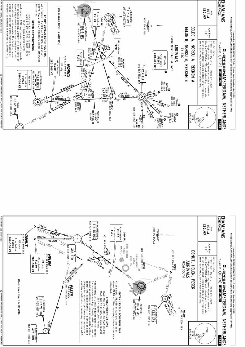
A
NORKU A, B11
| JEPPESEN
SAN
DERSO
N, IN
C., 2003. A
LL RIGHTS RESERV
ED.
Apt Elev
-11'
EHAM/A
MS
10-2.STA
R.
Tra
ns le
vel: B
y A
TC T
rans a
lt: 3000'
AMSTERD
AM, N
ETHERLA
NDS
SCHIPH
OL
ATIS
108.4
Alt S
et: h
Pa
1.Flig
hts
departin
g fro
m a
irports
situ
ate
d in
the A
MSTERDAM F
IR a
nd in
tendin
g to
opera
teat o
r belo
w 3
000' s
hould
obta
in a
n a
rrival s
lot
from S
CHIP
HOL A
PP b
efo
re d
epartu
re.
132.9
7
DSC
HIPH
OL
108.4 SPLSP
LN52 19.9 E004 45.0
D113.3 SPYSP
YN52 32.4 E004 51.2
SPIJKERBO
OR
D112.4 EELEEL
N53 09.8 E006 40.0
EELDE
D
11167^
R347^
REKKEN
116.8 RKN
RK
NN52 08.0 E006 45.8
D115.65 HMM
HM
MN51 51.4 E007 42.5
HAMM
FL100
FL70
At o
r belo
wat D
30 S
PL a
nd a
t or
above
NO
RKU STA
Rs revised.
MSA
1700'
2300' 311^
354^
SPL V
OR
D30 S
PL
242^062^
By ATC
2
252^
250 K
TFL7
0(IAF) 1
16
NO
VEN
2020
16
17
R024^R038^R050^
R083^ 204^218^230^263^
227^
39
1
1
1
11
27178^EELDE B
ARTIP
NA
RSO
N52 30.7
E005 34.2
By ATCFL200
1
43
220 KT
TMA
N53 12.8 E007 13.0
NO
T TO SC
ALE
E006 59.6N53 20.2
N52 42.6
E005 53.9
275^
1
16
310^
OSKUR
358^
REKKEN A
REKKEN BBy ATC
N52 29.4
E006 01.4
N53 23.9
E006 57.0
NO
RKU
SO
NSA
RO
BIS
N52 28.1
E006 28.0
N52 20.1
E006 44.7
TEM
LUSO
MPO
KUBA
T
DO
BA
K
2000
N53 28.5
E006 51.8
34.7
12.1CHA
NG
ES:
JEPPESEN
.Eff.20.Mar.
7 MA
R 03
ARRIV
ALS
FROM N
ORTH
EAST &
EAST
EELDE A
, NORK
U A
, REKKEN
A
EELDE B, N
ORK
U B, REK
KEN
BBY
ATC
FL1
00
At or below M
AX 2
50 K
T
At or aboveFL7
0
16.3
MAX
At or aboveFL7
0
1BEDUM
N53 20.9
E006 35.3
FL2
60
280-3
00 K
T
At or below
JET only
MAX
N52 42.9 E006 42.6
FL2
40
280-3
00 K
T
At or below
JET only
22.9
N52 12.9 E006 58.6
FL2
80
280-3
00 K
T
At or below
JET onlyC
learance lim
it is
ARTIP.
Additio
nally
ATC m
ay re
quest s
pecific
speeds
for a
ccura
te s
pacin
g. C
omply
with
any le
vel o
rspeed a
dju
stm
ent a
s s
oon a
s p
ossib
le w
ithin
opera
tional re
quire
ments
. If a le
vel o
r speed
change fo
r airc
raft p
erfo
rmance re
asons o
rweath
er c
onditio
ns is
necessary
, advis
e A
TC.
EN
TRY
LEV
ELS S
CH
IPH
OL T
MA
SPEED
REST
RIC
TIO
NS
(SLP =
Speed L
imit P
oin
t)
at T
MA b
oundary
unle
ss o
therw
ise
instru
cte
d.
MAX 2
50 K
T a
t SPL 3
0 D
ME (S
LP1)
MAX 2
20 K
T a
t SPL 1
5 D
ME (S
LP2)
Licensed to BR
ITISH A
IRW
AYS PLC
, . Printed from JeppView
disc 13-05.N
otice: After 21.7.2005 0901Z this chart should not be used w
ithout first checking JeppView or N
OTA
Ms.
D34
R224^
R107^
207^
SPY
212^D90
SPY
284^
D12.7
D17.4332^
027^
D86.5 PROHIB
ITEDA
REAEH
(P)-27 PROHIB
ITEDA
REAEH
(P)-26
HELEN
TMA
DENUT R196^
016^30
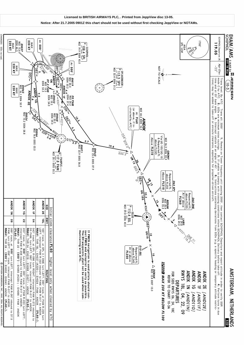
| JEPPESEN
SAN
DERSO
N, IN
C., 2003. A
LL RIGHTS RESERV
ED.
Apt Elev
-11'
EHAM/A
MS
.STAR.
Tra
ns le
vel: B
y A
TC T
rans a
lt: 3000'
AMSTERD
AM, N
ETHERLA
NDS
SCHIPH
OL
ATIS
108.4
Alt S
et: h
Pa
1.Flig
hts
departin
g fro
m a
irports
situ
ate
d in
the A
MSTERDAM F
IR a
nd in
tendin
g to
opera
teat o
r belo
w 3
000' s
hould
obta
in a
n a
rrival s
lot
from S
CHIP
HOL A
PP b
efo
re d
epartu
re.
132.9
7
D113.3 SPYSP
YN52 32.4 E004 51.2
SPIJKERBO
OR
DSC
HIPH
OL
108.4 SPLSP
LN52 19.9 E004 45.0
EINDHOVEN
397 EHN
EHN
N51 28.1 E005 23.7
DN51 26.9 E005 22.5EH
V(117.2) EH
VEIN
DHOVEN
STAD
386 STDSTD
N51 44.5 E004 14.6
HAAMSTED
E
114.15 HSD
HSD
N51 43.4 E003 51.5
NA
RIX
N52 39.2 E004 58.6
SO
KSI
N52 14.3 E004 21.9
10-2A
FL100
FL70
At o
r belo
wat D
30 S
PL a
nd a
t or
above
See other side.
MSA
1700'
2300' 311^
354^
SPL V
OR
(IAF)
RIV
ER
PESER
411
13
34
FL70
340^
308^
287^
D30 S
PL
15
044^
002^R182^
29
N51 14.1 E003 52.2HELE
N
N51 14.2 E003 39.5DENUT
NIR
SI
N52 35.0 E004 30.8
PESER
D33.3
EHV
242^062^
By ATC
NO
T TO SC
ALE
2000
CHA
NG
ES:
JEPPESEN
.Eff.20.Mar.
7 MA
R 03
ARRIV
ALS
MAX 2
50 K
T
Cle
arance lim
it is
RIV
ER.
DEN
UT, H
ELEN, PESER
FROM SO
UTH
MAX 250 KT
N51 54.8 E004 08.0
N51 36.9 E004 31.6
FL2
40
280-3
00 K
T
At or below
JET only
FL2
40
280-3
00 K
T
At or below
JET only
FL1
00
FL7
0
At or below
at or above
Additio
nally
ATC m
ay re
quest s
pecific
speeds
for a
ccura
te s
pacin
g. C
omply
with
any le
vel o
rspeed a
dju
stm
ent a
s s
oon a
s p
ossib
le w
ithin
opera
tional re
quire
ments
. If a le
vel o
r speed
change fo
r airc
raft p
erfo
rmance re
asons o
rweath
er c
onditio
ns is
necessary
, advis
e A
TC.
EN
TRY
LEV
ELS S
CH
IPH
OL T
MA
SPEED
REST
RIC
TIO
NS
(SLP =
Speed L
imit P
oin
t)
at T
MA b
oundary
unle
ss o
therw
ise
instru
cte
d.
MAX 2
50 K
T a
t SPL 3
0 D
ME (S
LP1)
MAX 2
20 K
T a
t SPL 1
5 D
ME (S
LP2)
Licensed to BR
ITISH A
IRW
AYS PLC
, . Printed from JeppView
disc 13-05.N
otice: After 21.7.2005 0901Z this chart should not be used w
ithout first checking JeppView or N
OTA
Ms.

D90.8257^
SPYD96.1
D56.3
D41.3 R24
3^
D85.9
353^NIK
117.4 NIK
D12.7
D17.4
284^
332^027^
HSD
114.15
R294^
D31
HSDR294^
D31
| JEPPESEN
SAN
DERSO
N, IN
C., 2003. A
LL RIGHTS RESERV
ED.
Apt Elev
-11'
EHAM/A
MS
.STAR.
Tra
ns le
vel: B
y A
TC T
rans a
lt: 3000'
AMSTERD
AM, N
ETHERLA
NDS
SCHIPH
OL
ATIS
108.4
Alt S
et: h
Pa
132.9
7
10-2B
VEREL
D113.3 SPYSPY
N52 32.4 E004 51.2
SPIJKERBOOR
DSCHIPHOL
108.4 SPLSPLN52 19.9 E004 45.0
NARIX
SOKSI
N52 39.2E004 58.6
DDEN HELDER
115.55 HDRHDRN52 54.4 E004 45.9
(SPL D38.5)
17
18
13
MOLIX
LAMSO
121^
121^
102^
062^
39.8
REDFA
078^
516
4
17 114^ TMA
FL100 FL70At or below at D30 SPL and at or above
1
11
N52 14.3 E004 21.9
HOLDING OVERSUGOL114^
DSCHIPHOL
108.4 SPLSPLN52 19.9 E004 45.0
Holding over SU
GO
L revised.
Flig
hts
departin
g fro
m a
irports
situ
ate
d in
the
AMSTERDAM F
IR a
nd in
tendin
g to
opera
te a
t or
belo
w 3
000' s
hould
obta
in a
n a
rrival s
lot fro
m
SCHIP
HOL A
PP b
efo
re d
epartu
re.
MSA
1700'
2300' 311^
354^
SPL V
OR
CHA
NG
ES:
JEPPESEN
ARRIV
ALS
FL70
E003 46.6
SUGOL(IAF)
D30 SPL
N52 34.3
4
N52 06.9 E002 29.3REDFA
SULUT
MOLIXN52 49.3 E003 04.1
NIRSIN52 35.0E004 30.8
242^062
^
By ATC
2000
MAX
250
KT
FL230280-300 KT
At or below
JET only
N52 31.5 E003 58.0
FL100At or below
LAMSON52 44.0 E002 59.7
PEPEL
LUTEXN52 40.9E003 28.1
3.5
FL70
At orabove
FL70At or above
FROM W
EST
N52 35.1 E003 24.9
N52 26.9 E003 25.3
Clearance limit is SUGOL.
NOT TO SCALE
LAMSO
, MOLIX
REDFA
ENTRY LEVELS SCHIPHOL TMA
SPEED RESTRICTIONS
(SLP = Speed Limit Point)
MAX 250 KT at SPL 30 DME (SLP1)MAX 220 KT at SPL 15 DME (SLP2)
Additionally ATC may request specific speeds for accurate spacing.Comply with any level or speed adjustment as soon as possible withinoperational requirements. If a level or speed change for aircraft per-formance reasons or weather conditions is necessary, advise ATC.
at TMAboundary unless otherwise instructed.
MAX 250 KT
25 APR 03
FL230At or below
JET only
280-300 KT
FL230280-300 KT
At or below
JET onlyLicensed to B
RITISH
AIR
WA
YS PLC, . Printed from
JeppView disc 13-05.
Notice: A
fter 21.7.2005 0901Z this chart should not be used without first checking JeppView
or NO
TAM
s.
D41.3
R243^
D85.9353^NIK
117.4
NIK
D12.7
D17.4
284^
332^
HSD114.15
R294^
D31
HSD
R294^
D31
027^
| JEPPESEN
SAN
DERSO
N, IN
C., 2003. A
LL RIGHTS RESERV
ED.
Apt Elev
-11'
EHAM/A
MS
.STAR.
Tra
ns le
vel: B
y A
TC T
rans a
lt: 3000'
AMSTERD
AM, N
ETHERLA
NDS
SCHIPH
OL
ATIS
108.4
Alt S
et: h
Pa
132.9
7
10-2C
FL100
FL70
At o
r belo
wat D
30 S
PL a
nd a
t or
above
D113.3 SPYSP
YN52 32.4 E004 51.2
SPIJKERBO
OR
DSC
HIPH
OL
108.4 SPLSP
LN52 19.9 E004 45.0
NA
RIX
SO
KSI
N52 39.2
E004 58.6
DDEN
HELD
ER
115.55 HDR
HD
RN52 54.4 E004 45.9
VEREL
(SPL D38.5)
(117.4 NIK
R-353/D136.4)
11
176^
172^
39
114^
TMA
1
N52 14.3
E004 21.9
Holding over SU
GO
L revised.
Flig
hts
departin
g fro
m a
irports
situ
ate
d in
the
AMSTERDAM F
IR a
nd in
tendin
g to
opera
te a
t or
belo
w 3
000' s
hould
obta
in a
n a
rrival s
lot fro
m
SCHIP
HOL A
PP b
efo
re d
epartu
re.
HO
LDIN
G O
VER
SUG
OL
114^
DSC
HIPH
OL
108.4 SPLSP
LN52 19.9 E004 45.0 M
SA
1700'
2300' 311^
354^
SPL V
OR
NO
T TO SC
ALE
CHA
NG
ES:
JEPPESEN
ARRIV
AL
Additio
nally
ATC m
ay re
quest s
pecific
speeds
for a
ccura
te s
pacin
g. C
omply
with
any le
vel o
rspeed a
dju
stm
ent a
s s
oon a
s p
ossib
le w
ithin
opera
tional re
quire
ments
. If a le
vel o
r speed
change fo
r airc
raft p
erfo
rmance re
asons o
rweath
er c
onditio
ns is
necessary
, advis
e A
TC.
EN
TRY
LEV
ELS S
CH
IPH
OL T
MA
SPEED
REST
RIC
TIO
NS
(SLP =
Speed L
imit P
oin
t)
at T
MA b
oundary
unle
ss o
therw
ise
instru
cte
d.
MAX 2
50 K
T a
t SPL 3
0 D
ME (S
LP1)
MAX 2
20 K
T a
t SPL 1
5 D
ME (S
LP2)
D30 S
PL
NIR
SI
N52 35.0
E004 30.8
242^062^
By ATC
2000
FL1
00
SUG
OL
(IAF)
N53 24.2 E003 33.7
TO
PPA4
N52 31.5 E003 58.0
MO
NIL
N52 45.7
E003 44.8
3.5
FL7
0A
t or above
Cle
arance lim
it is
SU
GO
L.
TOPPA
FROM N
ORTH
WEST
N52 34.3 E003 46.6
FL2
50
280-3
00 K
T
At or below
JET only
MAX 2
50 K
T
FL1
00
At or below
25 APR 03
FL7
0M
AX 2
50 K
T
Licensed to BR
ITISH A
IRW
AYS PLC
, . Printed from JeppView
disc 13-05.N
otice: After 21.7.2005 0901Z this chart should not be used w
ithout first checking JeppView or N
OTA
Ms.
D
054^D19.4
D55.4
R225^DHE116.3
EHD
096^
228^
223^
R273^
R267^
D25.2
500'
500'
089^ tra
ck, a
t
223^ tra
ck, a
t
RN
AV
:
RN
AV
:THR 0
9 -
RN
AV
:THR 2
2 -
- EH052 - E
H043 - A
NDIK
RN
AV
:THR 1
8L - E
H037 (K
220-) - E
H024 - P
AM - A
NDIK
(500')
- EH065 (K
220-) - E
H066 - P
AM - A
NDIK
(500')
Apt Elev
-11'
Tra
ns le
vel: B
y A
TC T
rans a
lt: 3000'
SCHIPH
OL D
eparture (R)
119.0
5
1.
2.
SID
s a
re m
inim
um n
ois
e ro
utin
gs.
3.
4.
5.
Inte
rcept ra
dia
ls a
t an a
ngle
of 4
5^.
6.
DEELD
E112.4 EELEEL
N53 09.8 E006 40.0
D113.3 SPYSP
YN52 32.4 E004 51.2
D108.4 SPLSP
LN52 19.9 E004 45.0
DPA
MPU
S117.8 PA
MP
AMN52 20.1 E005 05.5
SPIJKERBO
OR
SCHIPH
OL
223^ 043^
089^087^
185^
085^095^
EH037
N52 15.6
E004 46.5
3.1DM
E
EH024
AN
DIK 2
E
AN
DIK 1
G
N52 15.2 E004 58.8 028^
042^
R208^
R222^
EH066
N52 16.8 E005 03.0
EH071
N52 22.9 E005 06.8
EH019
N52 20.3
E004 50.2
EH043
N52 25.5 E005 07.9
EH068
N52 20.2
E004 59.0
062^
056^
EH052
N52 19.5
E004 54.0
D5 P
AM
N52 20.2
E004 57.4
N52 19.5
E004 53.3
D7.5
PA
M
4
EH065
AN
DIK
1F
AN
DIK
1N
N52 16.1 E004 50.9
017^2.9
093^
185^ tra
ck, a
t SPL 3
.1 D
ME tu
rn L
EFT, 0
95^ tra
ck, a
t PAM R
-228 tu
rnLEFT, in
terc
ept P
AM R
-222 in
bound to
PAM, P
AM R
-017 to
ANDIK
.
043^ tra
ck, a
t SPL R
-096 tu
rn R
IGHT, in
terc
ept P
AM R
-273 in
bound to
D5 P
AM, tu
rn L
EFT, 0
62^ tra
ck, in
terc
ept P
AM R
-017 to
ANDIK
.
turn
LEFT, 0
85^ tra
ck, a
t PAM R
-223 tu
rn L
EFT,
inte
rcept P
AM R
-208 in
bound to
PAM, P
AM R
-017 to
ANDIK
.
turn
LEFT, in
terc
ept P
AM R
-267 in
bound to
D7.5
PAM, tu
rn L
EFT, 0
56^ tra
ck, in
terc
ept P
AM R
-017 to
ANDIK
.
FOR SID
S RWYS 06, 24, 18C
REFER TO C
HART 10-3A
[AN
DI2
E]ANDIK 2E
ANDIK 1F
[AN
DI1
F]ANDIK 1G
[AN
DI1
G]
[AN
DI1
N]
ANDIK 1N
RWYS 18L, 04, 22, 09DEPA
RTURES
If unable
to c
omply
with
cro
ssin
g c
onditio
ns in
form
SCHIP
HOL D
eliv
ery
befo
re ta
ke-o
ff.mode C
by A
TC.
Remain
on T
ower fre
quency u
ntil p
assin
g 2
000', th
en c
onta
ct S
CHIP
HOL D
epartu
re a
nd re
port a
ltitude in
ord
er to
verify
SSR
Perfo
rm tu
rns in
due
time a
nd a
t 25^ b
ank a
ngle
.In
stru
ctio
ns c
onta
inin
g d
evia
tions fro
m S
IDs (e
.g. a
specific
headin
g o
r tempora
ry a
ltitude re
stric
-
19.6
2.7
5.5
10.5
0.4
5
3.6
6.4
2
7.57
.6
2
4.4
THR 0
4 - E
H019 - E
H068 - E
H071 - A
NDIK
(FL60+).
(FL60+).
(FL60+).
(FL60+).
1
MSA
1700'
2300' 311^
354^
SPL V
OR
CHA
NG
ES:
JEPPESEN
.Eff.18.Mar.
.SID.
EHAM/A
MS
10-3AMSTERD
AM, N
ETHERLA
NDS
SCHIPH
OL
5 MA
R 04
BEDUM
GRO
NY
N53 06.3 E006 03.3
D65 S
PY
D60 D
HE
D10 E
EL
9
3
36
R263^
083^
083^10
10
UG
10
UG
105
045^
N53 12.8 E007 13.0
N53 20.9
E006 35.3
ANDIK
N52 44.4 E005 16.2
04
NO
T TO SC
ALE
09
22
UR 1
2DO
BA
K
LABIL
N53 29.8
E006 49.0
9.6
22.4
AN
DIK
1F
AN
DIK
1N
AN
DIK
1G
RW
YSID
AN
DIK
2E
18L
FL2
50
At or above
Requested FLabove FL245
FL2
10
Requested FLabove FL255
Above
At
FL6
0(or above, if in-structed by A
TC)
FL2
10
above FL245
Above
& Requested FL
Via U
G 105/U
G 10
At
500'
220 K
TM
AX
220 K
TM
AX
At
500'
If F
MC
S n
avig
atio
n is
used p
ilots s
hould
con-
nect F
MC
S a
nd a
utopilo
t a
s e
arly
as p
ossib
le.
The E
H w
aypoin
ts s
hall n
ot b
e u
sed w
hen c
om
-m
unic
atin
g w
ith A
TC
.
Initia
l clim
b c
leara
nceFL60
| JEPPESEN
SAN
DERSO
N, IN
C., 2003, 2004. A
LL RIGHTS RESERV
ED.
SIDs revised.
MA
X 2
50 K
T B
ELO
W F
L100
hig
her le
vel o
nly
when c
leare
d b
y A
TC
tions) m
ay b
e a
dded to
take-o
ff or e
nro
ute
cle
ara
nce, e
specia
lly fo
r pro
pelle
r-driv
en a
ircra
ft.
FL2
60
At or above
Requested FLabove FL255
15
UR 1
2
220 K
TM
AX
220 K
TM
AX
RO
UTIN
G
SPEED:
Licensed to BRITISH AIRWAYS PLC, . Printed from JeppView disc 13-05.
Notice: After 21.7.2005 0901Z this chart should not be used without first checking JeppView or NOTAMs.

D55.4
R273^103^
233^
228^
D
D
R225^DHE116.3
EHD
D25.2
RN
AV
:
RN
AV
:
RN
AV
:
RN
AV
:
Apt Elev
-11'SC
HIPH
OL D
eparture (R)
119.0
5
D113.3 SPYSP
YN52 32.4 E004 51.2
SPIJKERBO
OR
1Jet a
ircra
ft only
betw
een 0
600-2
300LT.
Only
jet a
ircra
ft betw
een 2
300-0
600LT.
2
060^ tra
ck, a
t SPL R
-103 tu
rn R
IGHT, in
terc
ept P
AM R
-273 in
bound
to D
5 P
AM, tu
rn L
EFT, 0
62^ tra
ck, in
terc
ept P
AM R
-017 to
ANDIK
.
12
D108.4 SPLSP
LN52 19.9 E004 45.0
DPA
MPU
S
117.8 PAM
PAM
N52 20.1 E005 05.5
SCHIPH
OL
042^
R222^
EH071
N52 22.9 E005 06.8
EH068
N52 20.2
E004 59.0
062^
D5 P
AM
N52 20.2
E004 57.4
0172.9
EH014
093^A
ND
IK
1R
EH026
N52 10.3 E004 52.2
120^ 240^
185^
EH046
N52 13.1 E004 43.8
EH001 4
DME
25
5
ANDIK 2X
5.5DME
ANDIK
1S
060^
N52 16.5
E004 42.1
320^
064^
R244^
054^
ANDIK
1T
EH021
N52 28.6
E004 39.4
19.4
DEELD
E
112.4 EELEEL
N53 09.8 E006 40.0
ANDIK 1S
[AN
DI1
S]ANDIK 1T
[AN
DI1
T]
ANDIK 1R
[AN
DI1
R]
ANDIK 2X
[AN
DI2
X]
RWYS 06, 24, 18C
DEPA
RTURES
240^ tra
ck, a
t SPL 4
DME tu
rn L
EFT, 1
20^ tra
ck, a
t PAM R
-233 tu
rnLEFT, in
terc
ept P
AM R
-222 in
bound to
PAM, P
AM R
-017 to
ANDIK
.
060^ tra
ck, a
t SPL R
-103 tu
rn L
EFT, 3
20^ tra
ck, a
t SPY R
-228 tu
rn
RIG
HT, in
terc
ept S
PY R
-244 in
bound to
SPY, S
PY R
-054 to
ANDIK
.
185^ tra
ck, a
t SPL 5
.5 D
ME tu
rn L
EFT, 1
20^ tra
ck, a
t PAM R
-233 tu
rn
LEFT, in
terc
ept P
AM R
-222 in
bound to
PAM, P
AM R
-017 to
ANDIK
.
Tra
ns le
vel: B
y A
TC T
rans a
lt: 3000'
1.
2.
SID
s a
re m
inim
um n
ois
e ro
utin
gs.
3.
4.
5.
Inte
rcept ra
dia
ls a
t an a
ngle
of 4
5^.
6.
If unable
to c
omply
with
cro
ssin
g c
onditio
ns in
form
SCHIP
HOL D
eliv
ery
befo
re ta
ke-o
ff.mode C
by A
TC.
Remain
on T
ower fre
quency u
ntil p
assin
g 2
000', th
en c
onta
ct S
CHIP
HOL D
epartu
re a
nd re
port a
ltitude in
ord
er to
verify
SSR
Perfo
rm tu
rns in
due
time a
nd a
t 25^ b
ank a
ngle
.In
stru
ctio
ns c
onta
inin
g d
evia
tions fro
m S
IDs (e
.g. a
specific
headin
g o
r tempora
ry a
ltitude re
stric
-
22.3
12.8
4
5.9
11.3
3.4
5.5
8.2
THR 0
6 - E
H014 - E
H068 - E
H071 - A
NDIK
THR 2
4 - E
H001 - E
H026 - P
AM - A
NDIK
THR 0
6 - E
H014 (K
220-) - E
H021 - S
PY - A
NDIK
THR 1
8C - E
H046 - E
H026 - P
AM - A
NDIK
(FL60+).
(FL60+).(FL60+).
(FL60+).
1
N52 20.3 E004 51.8
MSA
1700'
2300' 311^
354^
SPL V
OR
CHA
NG
ES:
GRO
NY
N53 06.3 E006 03.3
ANDIK
N52 44.4 E005 16.2
24
06
AN
DIK
1S
AN
DIK
2X
AN
DIK
1T
AN
DIK
1R
At
FL6
0(or above, if in-structed by A
TC)
FL2
10
above FL245
Above
& Requested FL
Via U
G 105/U
G 10
06
18C
220 K
TM
AX
220 K
TM
AX
If F
MC
S n
avig
atio
n is
used p
ilots s
hould
con-
nect F
MC
S a
nd a
utopilo
t a
s e
arly
as p
ossib
le.
The E
H w
aypoin
ts s
hall n
ot b
e u
sed w
hen c
om
-m
unic
atin
g w
ith A
TC
.
BEDUM
D65 S
PY
D60 D
HE
D10 E
EL
9
3
R263^
083^
083^10
10
UG
10
UG
105
045^
N53 12.8 E007 13.0
N53 20.9
E006 35.3
UR 1
2DO
BA
K
LABIL
N53 29.8
E006 49.0
9.6
22.4
RW
YSID
FL2
50
At or above
Requested FLabove FL245
FL2
10
Requested FLabove FL255
Above
Initia
l clim
b c
leara
nce
FL60
MA
X 2
50 K
T B
ELO
W F
L100
FL2
60
At or above
Requested FLabove FL255
36
NO
T TO SC
ALE
.SID.
JEPPESEN
.Eff.18.Mar. EH
AM/A
MS
AMSTERD
AM, N
ETHERLA
NDS
SCHIPH
OL
10-3A5 M
AR 04
SIDs revised.
hig
her le
vel o
nly
when c
leare
d b
y A
TC
| JEPPESEN
SAN
DERSO
N, IN
C., 2003, 2004. A
LL RIGHTS RESERV
ED.
tions) m
ay b
e a
dded to
take-o
ff or e
nro
ute
cle
ara
nce, e
specia
lly fo
r pro
pelle
r-driv
en a
ircra
ft.
15
UR 1
2
RO
UTIN
G
220 K
TM
AX AN
DIK
1T
SPEED:
Licensed to BRITISH AIRWAYS PLC, . Printed from JeppView disc 13-05.
Notice: After 21.7.2005 0901Z this chart should not be used without first checking JeppView or NOTAMs.

D51
PROHIB
ITEDA
REAEH
(P)-25
254^
187^
213^
D19.4
108^
SPY113.3SPY
D39
113^
SO
NEB
N52 01.4 E006 45.9
TEBRO
N51 53.7 E006 35.3
DID
AM
131^
12
13N52 02.1
E006 19.6
105^13
N51 58.2 E007 06.5
SUV
OX
R287^
12
KO
MO
TN51 37.7 E007 04.5
500'
043^ tra
ck, a
t
269^ tra
ck, a
t500'
RN
AV
:THR 2
7 -
132^
107^23
31.6
FOR SID
S RWYS 06, 24, 18C
REFER TO C
HART 10-3C
500'
223^ tra
ck, a
t
RN
AV
:
RN
AV
:
RN
AV
:THR 2
2 -
RN
AV
:
(500')
Apt Elev
-11'SC
HIPH
OL D
eparture (R)
119.0
5
THR 0
4 -
(500')
(500')
[ARN
E2E]
ARN
EM 2E
[ARN
E1F]
ARN
EM 1F
ARN
EM 1G
[ARN
E1G
]ARN
EM 1N
[ARN
E1N
]
RWYS 18L, 04, 22, 09, 27
DEPA
RTURES
ARN
EM 1P
[ARN
E1P]
DHAMM
115.65 HMM
HM
MN51 51.4 E007 42.5
turn
RIG
HT, in
terc
ept S
PL R
-108 v
ia IV
LUT to
ARNEM.
185^ tra
ck, a
t SPL 3
.1 D
ME tu
rn L
EFT, 0
95^ tra
ck to
IVLUT, in
terc
ept S
PL R
-108 to
ARNEM.
turn
LEFT, 0
85^ tra
ck, in
terc
ept S
PL R
-108 v
ia IV
LUT to
ARNEM.
089^ tra
ck, a
t SPL 4
DME tu
rn R
IGHT, 1
15^ tra
ck, in
terc
ept S
PL R
-108 v
ia IV
LUT to
ARNEM.
turn
RIG
HT, 2
90^ tra
ck, a
t SPL 2
.5 D
ME tu
rn L
EFT, in
terc
ept S
PY R
-213
to D
18 S
PY, tu
rn L
EFT, in
terc
ept 1
38^ b
earin
g to
ward
s N
V, a
t SPL R
-187 tu
rn L
EFT, in
ter-
cept 0
74^ b
earin
g fro
m N
V to
IVLUT, in
terc
ept S
PL R
-108 to
ARNEM.
ARN
EM
1F
D108.4 SPLSP
LN52 19.9 E004 45.0
DPA
MPU
S117.8 PA
MP
AMN52 20.1 E005 05.5
SCHIPH
OL
NVSC
HIPH
OL
332 NV
N52 09.1 E004 45.9
EH066
N52 16.8 E005 03.0
EH037
N52 15.6 E004 46.5
EH065 E
H055
N52 19.3 E004 52.0
EH042
138^
074^
ARN
EM 1P
N52 10.6 E004 43.5
EH032
N52 15.9
E004 35.3
N52 17.1
E004 35.9
D18 S
PY
EH056
N52 19.8 E004 39.1
269^
290^
2.5 DME
19
8
N52 17.7
E004 57.7
115^089^043^
223^
3.1DM
E
185^
085^095^
EH060
N52 18.3
E004 54.4
ARN
EM
1G
ARN
EM
2E
ARN
EM
1N
4 DME
10
Tra
ns le
vel: B
y A
TC T
rans a
lt: 3000'
1.
2.
SID
s a
re m
inim
um n
ois
e ro
utin
gs.
3.
4.
5.
Inte
rcept ra
dia
ls a
t an a
ngle
of 4
5^.
6.
If unable
to c
omply
with
cro
ssin
g c
onditio
ns in
form
SCHIP
HOL D
eliv
ery
befo
re ta
ke-o
ff.mode C
by A
TC.
Remain
on T
ower fre
quency u
ntil p
assin
g 2
000', th
en c
onta
ct S
CHIP
HOL D
epartu
re a
nd re
port a
ltitude in
ord
er to
verify
SSR
Perfo
rm tu
rns in
due
time a
nd a
t 25^ b
ank a
ngle
.In
stru
ctio
ns c
onta
inin
g d
evia
tions fro
m S
IDs (e
.g. a
specific
headin
g o
r tempora
ry a
ltitude re
stric
-
THR 1
8L - E
H037 (K
220-) - IV
LUT
- EH060 (K
220-) - IV
LUT
- EH065 (K
220-) - E
H066 - IV
LUT
THR 0
9 - E
H055 - E
H042 - IV
LUT
- EH056 - E
H032 (K
220-) - N
V - IV
LUT
ARNEM.A
RNEM.
ARNEM.
ARNEM.
ARNEM.
17.8
7.5
N52 16.1 E004 50.9
2
5
3.8
3.3
3
5
4
2.1
3.3
1.2
7.3
(FL60+) -
(FL60+) -(
FL60+) -
(FL60+) -
(FL60+) -
2.1
MSA
1700'
2300' 311^
354^
SPL V
OR
ARNEM
100^26
UL 6
20
UL 603
N52 05.8
E006 04.6
27
ARN
EM
1P
CHA
NG
ES:
JEPPESEN
.Eff.18.Mar.
.SID.
EHAM/A
MS
AMSTERD
AM, N
ETHERLA
NDS
SCHIPH
OL
5 MA
R 04
04
NO
T TO SC
ALE
09
22
ARN
EM
1F
ARN
EM
1N
ARN
EM
1G
MA
X 2
50 K
T B
ELO
W F
L100
ARN
EM
2E
18L
10-3B
FL2
50
At or above
Requested FLabove FL245
Requested FLabove FL245
Above
FL2
10
FL2
50
At or above
Requested FLabove FL245
IVLU
TN52 14.7 E005 15.4
At
FL6
0(or above, if in-structed by A
TC)
At
500'
At
500'
220 K
TM
AX
220 K
TM
AX
220 K
TM
AX
If F
MC
S n
avig
atio
n is
used p
ilots s
hould
con-
nect F
MC
S a
nd a
utopilo
t a
s e
arly
as p
ossib
le.
The E
H w
aypoin
ts s
hall n
ot b
e u
sed w
hen c
om
-m
unic
atin
g w
ith A
TC
.
tions) m
ay b
e a
dded to
take-o
ff or e
nro
ute
cle
ara
nce, e
specia
lly fo
r pro
pelle
r-driv
en a
ircra
ft.
RW
YSID
Initia
l clim
b c
leara
nce
FL60
hig
her le
vel o
nly
when c
leare
d b
y A
TC
RO
UTIN
G
SIDs revised.
| JEPPESEN
SAN
DERSO
N, IN
C., 2003, 2004. A
LL RIGHTS RESERV
ED.
12 N
M a
fter T
EBRO
Requested FLabove FL245
Above
FL2
10
220 K
TM
AX
220 K
TM
AX
220 K
TM
AX
220 K
TM
AX220 K
TM
AX
SPEED:
Licensed to BRITISH AIRWAYS PLC, . Printed from JeppView disc 13-05.
Notice: After 21.7.2005 0901Z this chart should not be used without first checking JeppView or NOTAMs.
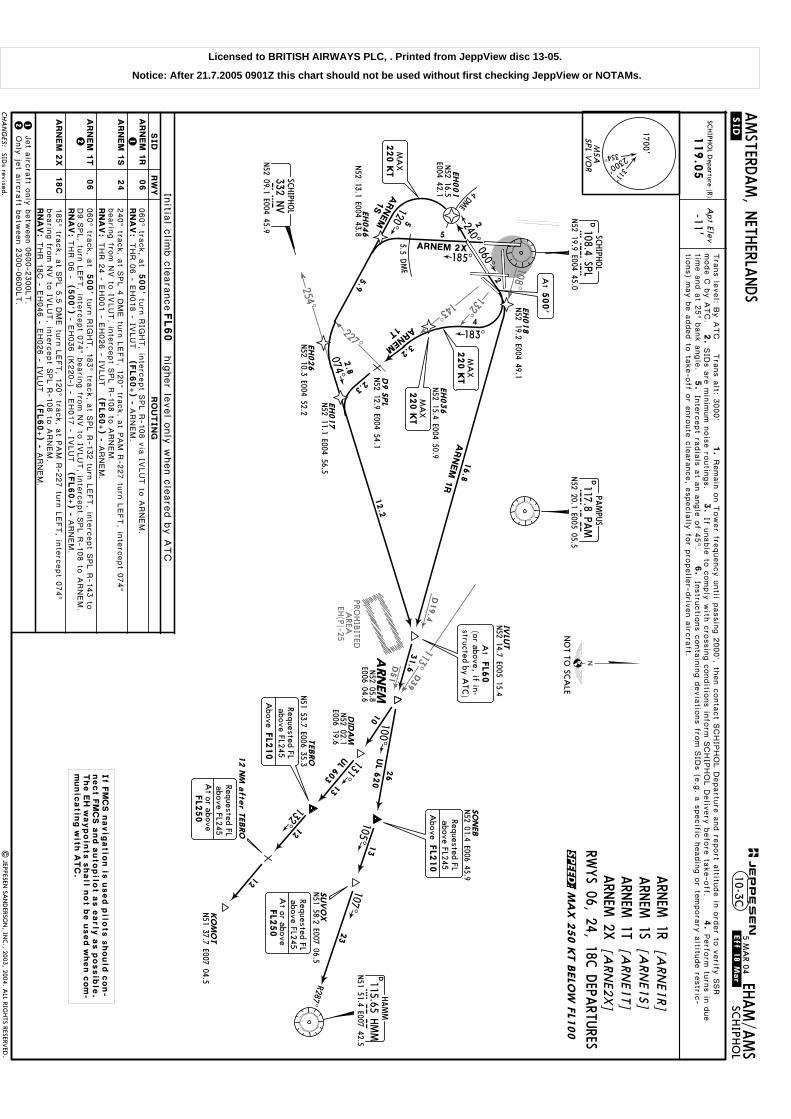
D19.4
D51
PROHIB
ITEDA
REAEH
(P)-25
D39
113^
254^
227^
108^
132^
143^
Apt Elev
-11'SC
HIPH
OL D
eparture (R)
119.0
5
RWYS 06, 24, 18C
DEPA
RTURES
ARN
EM 1R
[ARN
E1R]
ARN
EM 1S
[ARN
E1S]
ARN
EM 1T
[ARN
E1T]
ARN
EM 2X
[ARN
E2X]
500'
060^ tra
ck, a
t
RN
AV
:
THR 0
6 -
(500')
RN
AV
:
RN
AV
:
RN
AV
:tu
rn R
IGHT, in
terc
ept S
PL R
-108 v
ia IV
LUT to
ARNEM.
240^ tra
ck, a
t SPL 4
DME tu
rn L
EFT, 1
20^ tra
ck, a
t PAM R
-227 tu
rn L
EFT, in
terc
ept 0
74^
bearin
g fro
m N
V to
IVLUT, in
terc
ept S
PL R
-108 to
ARNEM.
060^ tra
ck, a
t500'
turn
RIG
HT, 1
83^ tra
ck, a
t SPL R
-132 tu
rn L
EFT, in
terc
ept S
PL R
-143 to
D9 S
PL, tu
rn L
EFT, in
terc
ept 0
74^ b
earin
g fro
m N
V to
IVLUT, in
terc
ept S
PL R
-108 to
ARNEM.
12Jet a
ircra
ft only
betw
een 0
600-2
300LT.
Only
jet a
ircra
ft betw
een 2
300-0
600LT.
12
185^ tra
ck, a
t SPL 5
.5 D
ME tu
rn L
EFT, 1
20^ tra
ck, a
t PAM R
-227 tu
rn L
EFT, in
terc
ept 0
74^
bearin
g fro
m N
V to
IVLUT, in
terc
ept S
PL R
-108 to
ARNEM.
D9 S
PL
D108.4 SPLSP
LN52 19.9 E004 45.0
SCHIPH
OL
EH026
N52 10.3 E004 52.2
EH036
EH018
N52 19.2 E004 49.1
EH017
N52 11.1 E004 56.5
SO
NEB
N52 01.4 E006 45.9
TEBRO
N51 53.7 E006 35.3
DID
AM
131^
12
13N52 02.1
E006 19.6
105^13
N51 58.2 E007 06.5
SUV
OX
R287^
12
KO
MO
TN51 37.7 E007 04.5
132^
107^23
31.6
DHAMM
115.65 HMM
HM
MN51 51.4 E007 42.5
DPA
MPU
S
117.8 PAM
PAM
N52 20.1 E005 05.5
10
060^
240^2
4
DME
185^ARNEM 2X
EH001
N52 16.5
E004 42.1
5.5DME
120^ARNEM
1S
EH046
N52 13.1 E004 43.8
074^
NVSC
HIPH
OL
332 NV
N52 09.1 E004 45.9
183^
ARNEM
1T
ARNEM
1R
Tra
ns le
vel: B
y A
TC T
rans a
lt: 3000'
1.
2.
SID
s a
re m
inim
um n
ois
e ro
utin
gs.
3.
4.
5.
Inte
rcept ra
dia
ls a
t an a
ngle
of 4
5^.
6.
If unable
to c
omply
with
cro
ssin
g c
onditio
ns in
form
SCHIP
HOL D
eliv
ery
befo
re ta
ke-o
ff.mode C
by A
TC.
Remain
on T
ower fre
quency u
ntil p
assin
g 2
000', th
en c
onta
ct S
CHIP
HOL D
epartu
re a
nd re
port a
ltitude in
ord
er to
verify
SSR
Perfo
rm tu
rns in
due
time a
nd a
t 25^ b
ank a
ngle
.In
stru
ctio
ns c
onta
inin
g d
evia
tions fro
m S
IDs (e
.g. a
specific
headin
g o
r tempora
ry a
ltitude re
stric
-
THR 0
6 - E
H018 - IV
LUT
THR 2
4 - E
H001 - E
H026 - IV
LUT
- EH036 (K
220-) - E
H017 - IV
LUT
THR 1
8C - E
H046 - E
H026 - IV
LUT
ARNEM.
ARNEM.
ARNEM.
ARNEM.
16.8
5
5
2
4
2.3
2.8
12.2
3.2
5.9
N52 12.9 E004 54.1
N52 15.4 E004 50.9
(FL60+) -(FL60+) -
(FL60+) -
(FL60+) -
MSA
1700'
2300' 311^
354^
SPL V
OR
CHA
NG
ES:
NO
T TO SC
ALE
MA
X 2
50 K
T B
ELO
W F
L100
24
06
ARN
EM
1S
ARN
EM
2X
ARN
EM
1T
ARN
EM
1R
06
18C
ARNEM
100^26
UL 6
20
UL 603
N52 05.8
E006 04.6
FL2
50
At or above
Requested FLabove FL245
Requested FLabove FL245
Above
FL2
10
FL2
50
At or above
Requested FLabove FL245
IVLU
TN52 14.7 E005 15.4
At
FL6
0(or above, if in-structed by A
TC)
220 K
TM
AX
At
500'
If F
MC
S n
avig
atio
n is
used p
ilots s
hould
con-
nect F
MC
S a
nd a
utopilo
t a
s e
arly
as p
ossib
le.
The E
H w
aypoin
ts s
hall n
ot b
e u
sed w
hen c
om
-m
unic
atin
g w
ith A
TC
.
tions) m
ay b
e a
dded to
take-o
ff or e
nro
ute
cle
ara
nce, e
specia
lly fo
r pro
pelle
r-driv
en a
ircra
ft.
RW
YSID
Initia
l clim
b c
leara
nceFL60
hig
her le
vel o
nly
when c
leare
d b
y A
TC
RO
UTIN
G
SIDs revised.
| JEPPESEN
SAN
DERSO
N, IN
C., 2003, 2004. A
LL RIGHTS RESERV
ED.
12 N
M a
fter T
EBRO
Requested FLabove FL245
Above
FL2
10
220 K
TM
AX
220 K
TM
AX
.SID.
JEPPESEN
.Eff.18.Mar. EH
AM/A
MS
AMSTERD
AM, N
ETHERLA
NDS
SCHIPH
OL
10-3C5 M
AR 04
SPEED:
Licensed to BRITISH AIRWAYS PLC, . Printed from JeppView disc 13-05.
Notice: After 21.7.2005 0901Z this chart should not be used without first checking JeppView or NOTAMs.

096^
R185^
307^
D22
340^
D46.8
357^110.4269^
165^
018^
RTM
151^
RTM
N52 20.3
E004 50.2
BERGI
2E
N52 13.7 E004 48.0
N52 12.9
E004 35.8
EH009
500'
089^ tra
ck, a
t
RN
AV
:
RN
AV
:THR 0
9 -
RN
AV
:
185^ tra
ck, a
t500'
RN
AV
:THR 1
8L -
269^ tra
ck, a
t500'
RN
AV
:THR 2
7 -
Apt Elev
-11'SC
HIPH
OL D
eparture (R)
121.2
(500')
CH
SCHIPH
OL
N52 13.2 E004 33.5
D113.3 SPYSP
YN52 32.4 E004 51.2
SPIJKERBO
OR
ABEA
M C
H
388.5 CH
(500')
(500')
EH022
N52 40.8 E004 31.3
089^
223^ 043^
185^
D108.4 SPLSP
LN52 19.9 E004 45.0
SCHIPH
OL
EH019
320^
005^ BERGI 1F D2 S
PY
EH021
N52 28.6 E004 39.4
EH053
N52 23.2
E004 47.4
BERGI 1N
8DME
EH028
N52 21.5 E004 25.3
EH041
269^
286^
284^
331^
4
BERG
I 1
P
BERG
I 1
G
EH063
EH058
N52 19.8 E004 40.6
EH029
N52 11.3 E004 49.2
N52 16.5
E004 44.9
2.8 DME
N52 19.4
E004 25.6
N52 30.4 E004 51.1
turn
LEFT, 3
20^ tra
ck, in
terc
ept S
PL R
-340,
turn
LEFT, in
terc
ept S
PL R
-165, a
t D6.5
SPL
turn
RIG
HT, in
terc
ept 2
84^ b
earin
g to
ward
s C
H, a
t RTM R
-018
turn
RIG
HT, in
terc
ept 3
31^ b
earin
g fro
m C
H, in
terc
ept R
TM
R-3
57 to
BERGI.
223^ tra
ck, a
t SPL 2
.8 D
ME tu
rn R
IGHT, 2
86^ tra
ck, in
terc
ept
RTM R
-357 to
BERGI.
RTM R
-357 to
BERGI. tu
rn R
IGHT, in
terc
ept S
PL R
-269, in
terc
ept
- EH058 - E
H041 - B
ERGI
Tra
ns le
vel: B
y A
TC T
rans a
lt: 3000'
1.
2.
SID
s a
re m
inim
um n
ois
e ro
utin
gs.
3.
4.
5.
Inte
rcept ra
dia
ls a
t an a
ngle
of 4
5^.
6.
If unable
to c
omply
with
cro
ssin
g c
onditio
ns in
form
SCHIP
HOL D
eliv
ery
befo
re ta
ke-o
ff.mode C
by A
TC.
Remain
on T
ower fre
quency u
ntil p
assin
g 2
000', th
en c
onta
ct S
CHIP
HOL D
epartu
re a
nd re
port a
ltitude in
ord
er to
verify
SSR
Perfo
rm tu
rns in
due
time a
nd a
t 25^ b
ank a
ngle
.In
stru
ctio
ns c
onta
inin
g d
evia
tions fro
m S
IDs (e
.g. a
specific
headin
g o
r tempora
ry a
ltitude re
stric
-
14.8
9.4
23.6
10.2
7.2
7.3
6
2
2
3
2.6
9.2
12.2
9.4
2.1
8.4
N52 13.4
E004 33.3
THR 0
4 - E
H019 - S
PY - B
ERGI
THR 2
2 - E
H063 (K
220-) - E
H041 - B
ERGI
(FL60+). (FL60+).
(FL60+).
(FL60+).
(FL60+).
at D
20 S
PL tu
rn L
EFT, in
terc
ept S
PY R
-307 to
BERGI.
- EH053 - E
H021
(3000'+
) -
EH022 -
BERGI
2.5
1.5
2
RWYS 18L, 04, 22, 09, 27
DEPA
RTURES
[BER
G2E]
BERGI 2E
[BER
G1F]
BERGI 1F
BERGI 1G
[BER
G1G
]BERG
I 1N[B
ERG
1N
]BERG
I 1P[B
ERG
1P]
REFER TO C
HART 10-3E
FOR SID
S RWYS 06, 24, 36L, 18C
7.
Rwy 1
8L: E
xpect a
dditio
nal d
epartu
re in
stru
ctio
ns fro
m T
ower d
urin
g in
depen-
- EH029 (K
220-) - E
H009
(3000'+
) -
EH028 - B
ERGI
043^ tra
ck, a
t SPL R
-096 tu
rn L
EFT, in
terc
ept S
PY R
-185 in
-bound to
D2 S
PY, tu
rn L
EFT, in
terc
ept S
PY R
-307 to
BERGI.
MSA
1700'
2300' 311^
354^
SPL V
OR
BERG
I
N52 38.5
E004 32.9D20 S
PL
N52 44.9 E004 21.5
D6.5
SPL
27
BERG
I 1
P
CHA
NG
ES:
.SID.
EHAM/A
MS
AMSTERD
AM, N
ETHERLA
NDS
SCHIPH
OL
04
09
22
BERG
I 1
F
BERG
I 1
N
BERG
I 1
G
BERG
I 2
E18L
10-3DJEPPESEN
NO
T TO SC
ALE
3000'
Above
At
500'
220 K
TM
AX
3000'
Above
At
500'
At
500'
220 K
TM
AX
At
FL6
0(or above, if in-structed by A
TC)
RW
YSID
Initia
l clim
b c
leara
nce
.Eff.2.Sep.
hig
her le
vel o
nly
when c
leare
d b
y A
TC
tions) m
ay b
e a
dded to
take-o
ff or e
nro
ute
cle
ara
nce, e
specia
lly fo
r pro
pelle
r-driv
en a
ircra
ft.
3000'
Above
220 K
TM
AX
220 K
TM
AX
220 K
TM
AX
| JEPPESEN
SAN
DERSO
N, IN
C., 2003, 2004. A
LL RIGHTS RESERV
ED.
RO
UTIN
G
20 AUG
04
The E
H w
aypoin
ts s
hall n
ot b
e u
sed w
hen
com
munic
atin
g w
ith A
TC
.
BELO
W F
L100
MA
X 2
50 K
T
dent p
ara
llel d
epartu
re o
pera
tions.
Restrictions added & revised.
If F
MS n
avig
atio
n is
used p
ilots s
hould
connect F
MS a
s e
arly
as p
ossib
le.
FL60,
SPEED:
Licensed to BRITISH AIRWAYS PLC, . Printed from JeppView disc 13-05.
Notice: After 21.7.2005 0901Z this chart should not be used without first checking JeppView or NOTAMs.

307^
D22
340^
D46.8
357^110.4
151^
253^
PAM
117.8
RTMMTR
103^
332^
D28.8
006^
AMPN52 13.4
E004 33.3
Apt Elev
-11'
SCHIPH
OL D
eparture (R)
121.2
D108.4 SPLSP
LN52 19.9 E004 45.0
SCHIPH
OL
D113.95 AMS
AMS
N52 20.0 E004 42.3
AMSTERD
AM
EH009
CH
SCHIPH
OL
N52 13.2 E004 33.5
D113.3 SPYSP
YN52 32.4 E004 51.2
SPIJKERBO
OR
ABEA
M C
H
388.5 CH
EH022
N52 40.8 E004 31.3
320^
EH021
EH014
N52 20.3
E004 51.8
BERGI 1R
EH028
N52 21.5 E004 25.3
331^
N52 13.9
E004 36.3
D19 P
AM
EH051 226^
240^060^
4DM
E
EH001
EH015
N52 35.5 E004 44.1
SPL
BERGI 1S
N52 28.6
E004 39.4
N52 28.0 E004 39.7
BERGI 1Z
N52 14.6 E004 39.1
EH094
D7.5
SPL
235^
185^
SPL
2.5
DME
BERGI 2
X
DEPA
RTURES
N52 16.5 E004 42.1
BERGI 1S, 2X
Tra
ns le
vel: B
y A
TC T
rans a
lt: 3000'
7.2
12.2
9.4
9.5
2.5
23.6
10.2
11.3
4
6
2
1.9
1.9
9.4
2.6
RWYS 06, 24, 36L, 18C
BERGI 2X
[BER
G2X]
BERGI 2V
[BER
G2V]
BERGI 1R
[BER
G1R]
BERGI 1S
[BER
G1S]
BERGI 1Z
[BER
G1Z]
EH093
BERGI 2V
323^
N52 25.3 E004 43.1
SPL
4.6 DME
EH095
N52 34.4
E004 31.5
8.2
3.4
4
BERG
I 2
V:
004^005^
BERG
I 1
Z:
3
3
119.0
5
BERG
I 2V:
240^ tra
ck, a
t SPL 4
DME tu
rn L
EFT, 2
26^ tra
ck, in
terc
ept P
AM R
-253, a
t D19
PAM tu
rn R
IGHT, in
terc
ept 3
31^ b
earin
g fro
m C
H, in
terc
ept R
TM R
-357 to
BERGI.
185^ tra
ck, a
t SPL 2
.5 D
ME tu
rn R
IGHT, 2
35^ tra
ck, in
terc
ept P
AM R
-253, a
t D19 P
AM tu
rn R
IGHT, in
terc
ept 3
31^b
earin
g fro
m C
H, in
terc
ept R
TM R
-357 to
BERGI.
004^ tra
ck, a
t SPL 4
.6 D
ME tu
rn L
EFT, 3
23^ tra
ck, in
terc
ept S
PL R
-332 to
BERGI.
RN
AV
:
Jet a
ircra
ft only
betw
een 0
600-2
300LT.
Only
jet a
ircra
ft betw
een 2
300-0
600LT.
12
RN
AV
:
RN
AV
:
12RN
AV
:THR 3
6L - E
H015 - B
ERGI
RN
AV
:THR 1
8C -
(500')
005^ tra
ck, in
terc
ept A
MS R
-006, in
terc
ept S
PY R
-307 to
BERGI.
THR 0
6 - E
H014 (K
220-) - E
H021 - E
H022 - B
ERGI
(FL60+).
(FL60+).
THR 3
6L - E
H093 - E
H094
(3000'+
) -
EH095 - B
ERGI
(FL60+).
(FL60+).
THR 2
4 - E
H001 - E
H051 - E
H009
EH028 - B
ERGI
(3000'+
) -
- EH051 - E
H009
(FL60+).
EH028 - B
ERGI
(3000'+
) -
060^ tra
ck, a
t SPL R
-103 tu
rn L
EFT, 3
20^ tra
ck, in
terc
ept S
PL R
-340, a
t D20
SPL tu
rn L
EFT, in
terc
ept S
PY R
-307 to
BERGI.
1.
3.
4.
6.
If unable
to c
omply
with
cro
ssin
g c
onditio
ns in
form
SCHIP
HOL D
eliv
ery
befo
re ta
ke-o
ff.Remain
on T
ower fre
quency u
ntil p
assin
g 2
000', th
en c
onta
ct S
CHIP
HOL D
epartu
re a
nd re
port a
ltitude in
ord
er to
verify
SSR m
ode C
by A
TC.
2.
routin
gs.
SID
s a
re m
inim
um n
ois
ePerfo
rm tu
rns in
due tim
e a
nd a
t 25^ b
ank a
ngle
.5.
Inte
rcept
radia
ls a
t an a
ngle
of 4
5^.
Instru
ctio
ns c
onta
inin
g d
evia
tions fro
m S
IDs (e
.g. a
specific
headin
g o
r tempora
ry a
ltitude re
stric
tions) m
ay b
e a
dded to
take-o
ff or e
nro
ute
7.
Rwys 1
8C, 3
6L: E
xpect a
dditio
nal d
epartu
re in
stru
ctio
ns fro
m T
ower d
urin
g in
dependent p
ara
llel d
epartu
re o
pera
tions.
BERG
I 1R,1S, 2X
, 1Z:
MSA
1700'
2300' 311^
354^
SPL V
OR
The E
H w
aypoin
ts s
hall n
ot b
e u
sed w
hen
com
munic
atin
g w
ith A
TC
.
CHA
NG
ES:
BERG
I
N52 38.5
E004 32.9
D20 S
PL
N52 44.9 E004 21.5
.SID.
.Eff.2.Sep. EH
AM/A
MS
AMSTERD
AM, N
ETHERLA
NDS
SCHIPH
OL
10-3E
| JEPPESEN
SAN
DERSO
N, IN
C., 2003, 2004. A
LL RIGHTS RESERV
ED.
SID B
ERGI 1V
renumbered 2V
& revised; restrictions added &
revised.
20 AUG
04
NO
T TO SC
ALE
MA
X 2
50 K
T B
ELO
W F
L100
At
FL6
0(or above, if in-structed by A
TC)
JEPPESEN
At
500'
RNA
V only 2
20 K
TM
AX
220 K
TM
AX
3000'
Above
3000'
Above
If F
MS n
avig
atio
n is
used p
ilots s
hould
connect F
MS a
s e
arly
as p
ossib
le.
24
06
36L
BERG
I 1
R
BERG
I 1
S
BERG
I 2
V
BERG
I 1
Z
RW
YSID
18C
BERG
I 2
X
36L
RO
UTIN
G
Initia
l clim
b c
leara
nce
hig
her le
vel o
nly
when c
leare
d b
y A
TC
FL60,
cle
ara
nce, e
specia
lly fo
r pro
pelle
r-driv
en a
ircra
ft.
SPEED:
Licensed to BRITISH AIRWAYS PLC, . Printed from JeppView disc 13-05.
Notice: After 21.7.2005 0901Z this chart should not be used without first checking JeppView or NOTAMs.

269^D29
D21.9
244^
096^
Apt Elev
-11'SC
HIPH
OL D
eparture (R)
121.2
269^089^
EH058
N52 19.8 E004 40.6
VO
LLAN52 18.9 E004 09.4
GO
RLO
1P
EH021
N52 28.6 E004 39.4
8DM
E
EH059
N52 20.8 E004 51.0
EH053
N52 23.2 E004 47.4
3
GO
RLO
1N
GO
RLO
1F
D108.4 SPLSP
LN52 19.9 E004 45.0
SCHIPH
OL
GO
RLO
N51 55.5 E003 10.3
320^
043^
D113.3 SPYSP
YN52 32.4 E004 51.2
SPIJKERBO
OR
239^
RWYS 04, 09, 27 D
EPARTU
RESFO
R SIDS RW
YS 06, 36L
REFER TO C
HART 10-3G
GORLO
1F[G
ORL1
F]GORLO
1N[G
ORL1
N]
GORLO
1P[G
ORL1
P]
RN
AV
:
RN
AV
:
089^ tra
ck, a
t500'
(500')
THR 0
9 -
269^ tra
ck, a
t500'
RN
AV
:THR 2
7 -
(500')
(117.8 PAM
R-254/D75.2)
(110.4 RTM R-269/D
48.7)
Tra
ns le
vel: B
y A
TC T
rans a
lt: 3000'
1.
2.
SID
s a
re m
inim
um n
ois
e ro
utin
gs.
3.
4.
5.
Inte
rcept ra
dia
ls a
t an a
ngle
of 4
5^.
6.
If unable
to c
omply
with
cro
ssin
g c
onditio
ns in
form
SCHIP
HOL D
eliv
ery
befo
re ta
ke-o
ff.mode C
by A
TC.
Remain
on T
ower fre
quency u
ntil p
assin
g 2
000', th
en c
onta
ct S
CHIP
HOL D
epartu
re a
nd re
port a
ltitude in
ord
er to
verify
SSR
Perfo
rm tu
rns in
due
time a
nd a
t 25^ b
ank a
ngle
.In
stru
ctio
ns c
onta
inin
g d
evia
tions fro
m S
IDs (e
.g. a
specific
headin
g o
r tempora
ry a
ltitude re
stric
-
43.3
19.2
20.8
7.3
3.3
3
GORLO.
THR 0
4 - E
H059 (K
220-) - E
H021 - V
OLLA
- EH053 (K
220-) - E
H021 - V
OLLA
- EH058 - V
OLLA
GORLO.
GORLO.
(FL60+) -(
FL60+) -
(FL60+) -
3tu
rn R
IGHT, in
terc
ept S
PL R
-269 to
VOLLA, 2
39^ tra
ck to
GORLO.
turn
LEFT, 3
20^ tra
ck, a
t SPL 8
DME tu
rn L
EFT, in
terc
ept S
PY
R-2
44 to
VOLLA, 2
39^ tra
ck to
GORLO.
043^ tra
ck, a
t SPL R
-096 tu
rn L
EFT, 3
20^ tra
ck, a
t SPL 8
DME tu
rn L
EFT, in
terc
ept
SPY R
-244 to
VOLLA, 2
39^ tra
ck to
GORLO.
MSA
1700'
2300' 311^
354^
SPL V
OR
CHA
NG
ES:
JEPPESEN
.SID.
EHAM/A
MS
AMSTERD
AM, N
ETHERLA
NDS
SCHIPH
OL
10-3F
NO
T TO SC
ALE
At
500'
At
FL6
0(or above, if in-structed by A
TC)
220 K
TM
AX
At
500'
| JEPPESEN
SAN
DERSO
N, IN
C., 2003, 2004. A
LL RIGHTS RESERV
ED.
MA
X 2
50 K
T B
ELO
W F
L100
04
GO
RLO
1F
09
27
RW
YSID
Initia
l clim
b c
leara
nce
GO
RLO
1N
GO
RLO
1P
hig
her le
vel o
nly
when c
leare
d b
y A
TC
tions) m
ay b
e a
dded to
take-o
ff or e
nro
ute
cle
ara
nce, e
specia
lly fo
r pro
pelle
r-driv
en a
ircra
ft.
220 K
TM
AX
220 K
TM
AX
RO
UTIN
G
.Eff.2.Sep.
20 AUG
04
The E
H w
aypoin
ts s
hall n
ot b
e u
sed w
hen
com
munic
atin
g w
ith A
TC
.
FMS restriction revised.
If F
MS n
avig
atio
n is
used p
ilots s
hould
connect F
MS a
s e
arly
as p
ossib
le.
FL60,
SPEED:
Licensed to BRITISH AIRWAYS PLC, . Printed from JeppView disc 13-05.
Notice: After 21.7.2005 0901Z this chart should not be used without first checking JeppView or NOTAMs.
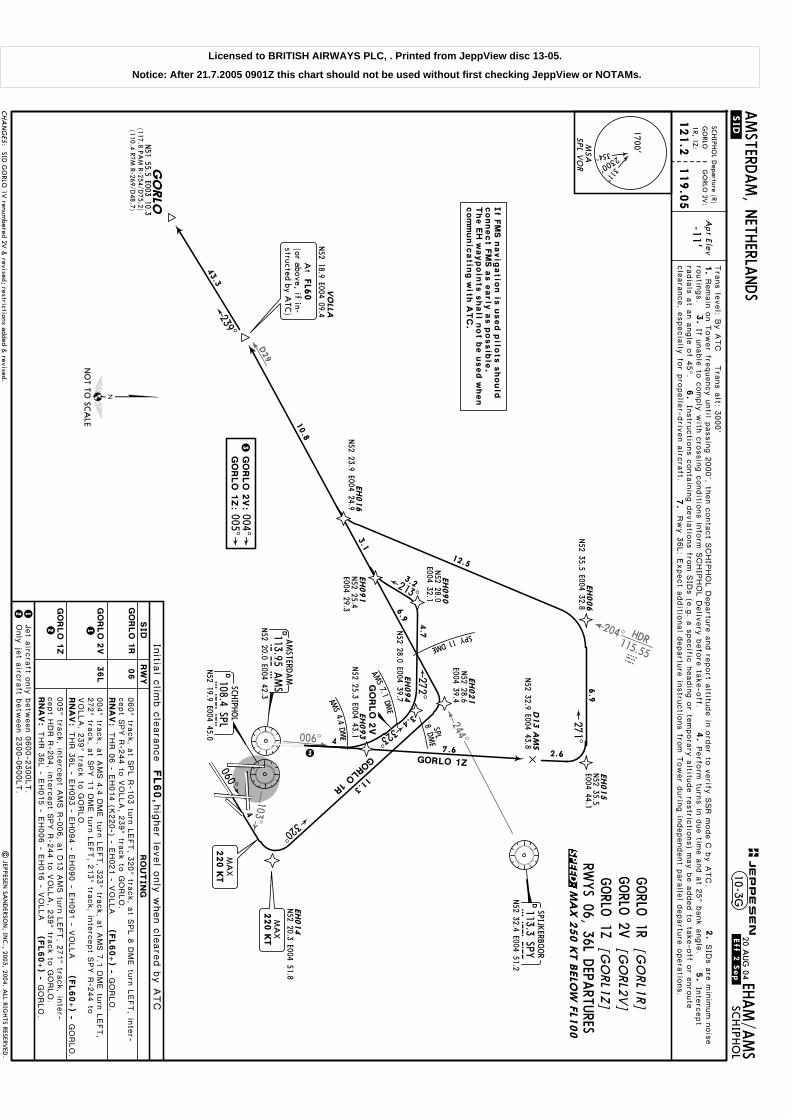
D29
244^
103^
204^ HDR115.55HDR
006^
VO
LLAN52 18.9 E004 09.4
EH021
D113.95 AMS
AMS
N52 20.0 E004 42.3
AMSTERD
AM
D108.4 SPLSP
LN52 19.9 E004 45.0
SCHIPH
OL
EH014
N52 20.3 E004 51.8
060^
320^
EH016
N52 23.9 E004 24.9
EH091
EH090
N52 28.0
E004 32.1GORLO
1R
213^
N52 28.6
E004 39.4
SPY11DME
8DM
ES PL
D13 A
MS
N52 32.9 E004 43.8
EH006
N52 35.5 E004 32.8
EH015
271^
GORLO 1Z
GO
RLO
2V
N52 25.4
E004 29.3
GO
RLO
N51 55.5 E003 10.3
239^
(117.8 PAM
R-254/D75.2)
(110.4 RTM R-269/D
48.7)
D113.3 SPYSP
YN52 32.4 E004 51.2
SPIJKERBO
OR
43.3
12.5
11.3
10.8
3.1
3.2
6.9
4
2.6
6.9
N52 35.5
E004 44.1
EH094
272^
EH093
N52 25.3 E004 43.1
N52 28.0 E004 39.7
323^
AMS 4.4 DM
E
AMS 7.1
DM
E 3.4
RWYS 06, 36L D
EPARTU
RES
GORLO
1R[G
ORL1
R]
GORLO
2V[G
ORL2
V]
GORLO
1Z[G
ORL1
Z]
4.7
7.6
Tra
ns le
vel: B
y A
TC T
rans a
lt: 3000'
GO
RLO
2V
:004^005^
GO
RLO
1Z:
3
1.
3.
4.
6.
If unable
to c
omply
with
cro
ssin
g c
onditio
ns in
form
SCHIP
HOL D
eliv
ery
befo
re ta
ke-o
ff.Remain
on T
ower fre
quency u
ntil p
assin
g 2
000', th
en c
onta
ct S
CHIP
HOL D
epartu
re a
nd re
port a
ltitude in
ord
er to
verify
SSR m
ode C
by A
TC.
2.
routin
gs.
SID
s a
re m
inim
um n
ois
ePerfo
rm tu
rns in
due tim
e a
nd a
t 25^ b
ank a
ngle
.5.
Inte
rcept
radia
ls a
t an a
ngle
of 4
5^.
Instru
ctio
ns c
onta
inin
g d
evia
tions fro
m S
IDs (e
.g. a
specific
headin
g o
r tempora
ry a
ltitude re
stric
tions) m
ay b
e a
dded to
take-o
ff or e
nro
ute
7.
Rwy 3
6L: E
xpect a
dditio
nal d
epartu
re in
stru
ctio
ns fro
m T
ower d
urin
g in
dependent p
ara
llel d
epartu
re o
pera
tions.
4
3Jet a
ircra
ft only
betw
een 0
600-2
300LT.
Only
jet a
ircra
ft betw
een 2
300-0
600LT.
12
RN
AV
:
RN
AV
:
RN
AV
:
12005^ tra
ck, in
terc
ept A
MS R
-006, a
t D13 A
MS tu
rn L
EFT, 2
71^ tra
ck, in
ter-
cept H
DR R
-204, in
terc
ept S
PY R
-244 to
VOLLA, 2
39^ tra
ck to
GORLO.
THR 0
6 - E
H014 (K
220-) - E
H021 - V
OLLA
THR 3
6L - E
H093 - E
H094 - E
H090 - E
H091 - V
OLLA
THR 3
6L - E
H015 - E
H006 - E
H016 - V
OLLA
GORLO.
(FL60+) -
GORLO.
(FL60+) -
GORLO.
(FL60+) -
004^ tra
ck, a
t AMS 4
.4 D
ME tu
rn L
EFT, 3
23^ tra
ck, a
t AMS 7
.1 D
ME tu
rn L
EFT,
272^ tra
ck, a
t SPY 1
1 D
ME tu
rn L
EFT, 2
13^ tra
ck, in
terc
ept S
PY R
-244 to
VOLLA, 2
39^ tra
ck to
GORLO.
060^ tra
ck, a
t SPL R
-103 tu
rn L
EFT, 3
20^ tra
ck, a
t SPL 8
DME tu
rn L
EFT, in
ter-
cept S
PY R
-244 to
VOLLA, 2
39^ tra
ck to
GORLO.
Apt Elev
-11'
SCHIPH
OL D
eparture (R)
121.2
119.0
5
GO
RLO 2V
:G
ORLO
1R, 1Z:MSA
1700'
2300' 311^
354^
SPL V
OR
CHA
NG
ES:
NO
T TO SC
ALE
220 K
TM
AX
.SID.
JEPPESEN
EHAM/A
MS
AMSTERD
AM, N
ETHERLA
NDS
SCHIPH
OL
10-3G
| JEPPESEN
SAN
DERSO
N, IN
C., 2003, 2004. A
LL RIGHTS RESERV
ED.
At
FL6
0(or above, if in-structed by A
TC)
220 K
TM
AX .Eff.2.Se
p.20 A
UG
04
MA
X 2
50 K
T B
ELO
W F
L100
The E
H w
aypoin
ts s
hall n
ot b
e u
sed w
hen
com
munic
atin
g w
ith A
TC
.
If F
MS n
avig
atio
n is
used p
ilots s
hould
connect F
MS a
s e
arly
as p
ossib
le.
cle
ara
nce, e
specia
lly fo
r pro
pelle
r-driv
en a
ircra
ft.
SID G
ORLO
1V renum
bered 2V &
revised; restrictions added & revised.
06
GO
RLO
2V
GO
RLO
1Z
36L
GO
RLO
1R
RW
YSID
Initia
l clim
b c
leara
nce
hig
her le
vel o
nly
when c
leare
d b
y A
TC
RO
UTIN
G
FL60,
SPEED:
Licensed to BRITISH AIRWAYS PLC, . Printed from JeppView disc 13-05.
Notice: After 21.7.2005 0901Z this chart should not be used without first checking JeppView or NOTAMs.

134^
D14.4 D31.1
D16
D62
D27.4
208^PAM117.8
PAM
180^
187^
D24.5
D37.2
183^
SPY
113.3
165^
213^
SPY
500'
089^ tra
ck, a
t
RN
AV
:
RN
AV
:THR 0
9 -
RN
AV
:
185^ tra
ck, a
t500'
RN
AV
:THR 1
8L -
RN
AV
:THR 2
7 -
Apt Elev
-11'SCHIPHOL Departure (R)
119.05
FOR SIDS RWYS 06, 24, 36LREFER TO CHART 10-3J
LEKKO 2E[LEKO2E]LEKKO 1F[LEKO1F]LEKKO 1G[LEKO1G]LEKKO 1N[LEKO1N]LEKKO 1P[LEKO1P]
RWYS 18L, 04, 22, 09, 27DEPARTURES
043^ tra
ck, a
t500'
THR 0
4 -
223^ tra
ck, a
t500'
THR 2
2 -
(500')
-EH073 - L
EKKO
(500')
-
(500')
-
(500')
-
269^ tra
ck, a
t500'
(500')
-
Via
or
Via
R 5
7:
089^
223^ 043^
185^
D108.4 SPLSP
LN52 19.9 E004 45.0
SCHIPH
OL
269^
DNICKY
117.4 NIK
NIKN51 09.9 E004 11.0
R028^
5
5
6
INKET
N51 48.9 E004 46.3
EINDHOVEN
397 EHN
EHN
N51 28.1 E005 23.7
31R 57
6.6
34.6UB 31
WO
ODY
N51 24.3 E004 22.0
D5 N
IK
D10 N
IK
UN 872
DRO
TTERDAM
110.4 RTMR
TMN51 58.4 E004 28.9
EH072
N52 01.2
E004 50.6
N52 03.5
E004 50.6
D29 S
PY
EH075
N52 09.4 E004 45.5
EH032
N52 15.9 E004 35.3
EH036
N52 15.4 E004 50.9
EH073
N52 12.9 E004 48.5
EH064
N52 15.1 E004 47.4
8
5
213^
LEKKO 1F
LEKKO 1N6.5
SPL
LEK
KO
1G
N52 17.1 E004 35.9
D18 S
PY
4
3
N52 13.7 E004 48.0
LEKKO 2E
9
LEKKO 1P
138^
EH056
N52 19.8
E004 39.1
2.5 DME290^
NVSC
HIPH
OL
332 NV
N52 09.1 E004 45.9
FOR SIDS RWYS 36C, 18CREFER TO CHART 10-3K
EH036 (K
220-) -
EH072 - L
EKKO
turn
RIG
HT, 2
13^ tra
ck,
inte
rcept S
PY R
-183, a
t D29 S
PY tu
rn R
IGHT,
inte
rcept P
AM R
-208 to
LEKKO.
turn
LEFT, in
terc
ept S
PL
R-1
65, a
t D6.5
SPL tu
rn R
IGHT, in
terc
ept
SPY R
-187 to
LEKKO.tu
rn L
EFT, in
terc
ept S
PL
R-1
65, in
terc
ept S
PY R
-187 to
LEKKO.
EH064 (K
220-) -
EH073 - L
EKKO
turn
RIG
HT, in
terc
ept
SPY R
-183, a
t D29 S
PY tu
rn R
IGHT, in
terc
ept
PAM R
-208 to
LEKKO.
EH036 (K
220-) -
EH072 - L
EKKO
turn
RIG
HT, 2
90^ tra
ck,
at S
PL 2
.5 D
ME tu
rn L
EFT, in
terc
ept S
PY
R-2
13, a
t D18 S
PY tu
rn L
EFT, in
terc
ept 1
38^
bearin
g to
ward
s N
V, in
terc
ept S
PL R
-180 to
LEKKO.
EH056 -
EH032 (K
220-) - E
H075 - L
EKKO
UB 3
1U
N 8
72.
Trans level: By ATC Trans alt: 3000'1.2.SIDs are minimum noise routings.3.4.
5.Intercept radials at an angle of 45^.6.If unable to comply with crossing conditions inform SCHIPHOL Delivery before take-off. mode C by ATC.
Remain on Tower frequency until passing 2000', then contact SCHIPHOL Departure and report altitude in order to verify SSRPerform turns in due
time and at 25^ bank angle.Instructions containing deviations from SIDs (e.g. a specific heading or temporary altitude restric-
(FL60+).
(FL60+).
(FL60+).
(FL60+).
(FL60+).
At L
EKKO in
terc
ept S
PL R
-180 to
INKET, in
ter-
cept R
TM R
-134 to
EHN.
0.9
1.4
122.2
6.4
13.9
3.3
4
1.2
17.5
MSA
1700'
2300
'311^ 35
4^
SPL VOR
27
CHANGES:
JEPPESEN
.SID.EHAM/AMSAMSTERDAM, NETHERLANDSSCHIPHOL
04
NO
T TO SC
ALE
09
22
18L
10-3H
MAX 250 KT BELOW FL100
LEK
KO
2E
LEK
KO
1F
LEK
KO
1G
LEK
KO
1N
LEK
KO
1P
LEKKO
N51 55.5 E004 46.0
FL2
60
At or above
Requested FLabove FL255
FL2
00
At or above
Requested FLbetw
eenFL195 &
FL245
FL2
40
Requested FLabove FL255
Above
FL1
90
FL195 & FL245
Above
Requested FL between
220 K
TM
AX
At
500'
At
500'
At
500'
At
500'
220 K
TM
AX
220 K
TM
AX
The E
H w
aypoin
ts s
hall
not b
e u
sed w
hen c
om
-m
unic
atin
g w
ith A
TC
.
If F
MC
S n
avig
atio
n is
used p
ilots s
hould
connect F
MC
S a
nd
autopilo
t a
s e
arly
as
possib
le.
.Eff.18.Mar.5 MAR 04
RW
YSID
Initia
l clim
b c
leara
nceFL60
| JEPPESEN SANDERSON, INC., 2003, 2004. ALL RIGHTS RESERVED.
hig
her le
vel o
nly
when c
leare
d b
y A
TC
At
FL6
0(or above, if in-structed by A
TC)
tions) may be added to take-off or enroute clearance, especially for propeller-driven aircraft.
SIDs revised; chart reindexed.
RO
UTIN
G
CO
NTIN
UA
TIO
N
220 K
TM
AX
220 K
TM
AX
220 K
TM
AX
SPEED:
Licensed to BR
ITISH A
IRW
AYS PLC
, . Printed from JeppView
disc 13-05.N
otice: After 21.7.2005 0901Z this chart should not be used w
ithout first checking JeppView or N
OTA
Ms.

D31.1 D24.5
D16
134^
D14.4
D62
D27.4
180^
183^
196^
R275^
143^
132^
006^
208^ PAM117.8
PAM
RN
AV
:
RN
AV
:
RN
AV
:
060^ tra
ck, a
t500'
RN
AV
:
RN
AV
:
Apt Elev
-11'SCHIPHOL Departure (R)
119.05
060^ tra
ck, a
t500'
THR 0
6 -
(500')
-
(500')
-
D108.4 SPLSP
LN52 19.9 E004 45.0
SCHIPH
OL
DNICKY
117.4 NIK
NIKN51 09.9 E004 11.0
INKET
N51 48.9 E004 46.3
EINDHOVEN
397 EHN
EHN
N51 28.1 E005 23.7
6.6
WO
ODY
N51 24.3 E004 22.0
D5 N
IK
D10 N
IK
DRO
TTERDAM
110.4 RTMR
TMN51 58.4 E004 28.9
EH072
N52 01.2
E004 50.6
N52 03.5
E004 50.6
D29 S
PY
NVSC
HIPH
OL
332 NV
N52 09.1 E004 45.9
LEKKO 1R[LEKO1R]LEKKO 1S[LEKO1S]LEKKO 1T[LEKO1T]LEKKO 1V[LEKO1V]LEKKO 1Z[LEKO1Z]
RWYS 06, 24, 36L DEPARTURES
1THR 0
6 -
212
R028^
5
5
6UN 872
31R 57
UB 31
240^2
4
DME
EH001
N52 16.5
E004 42.1
154^
8
LEKKO 1S
EH039
N52 09.6 E004 45.4 060^
EH013
N52 32.7 E004 43.8
N52 30.9 E004 43.6
D11 A
MS
D2.5
SPY
N52 32.6
E004 47.1
095^
EH084
N52 23.7 E004 42.9
EH085
N52 25.3 E004 51.1
073^LEKKO
1V
LEKKO 1Z
EH036
N52 15.4
E004 50.9
LEKKO
1TN52 12.1
E004 55.2
D10 S
PL
D113.3 SPYSP
YN52 32.4 E004 51.2
SPIJKERBO
OR
10
EH038
N52 10.2
E004 57.7
005^
SPY 11 D
ME
SPL 3 DME
N52 16.8
E004 50.9
12
LEK
KO
1R, 1
T
D113.95 AMS
AMS
N52 20.0 E004 42.3
AMSTERD
AM
12Jet a
ircra
ft only
betw
een 0
600-2
300LT.
Only
jet a
ircra
ft betw
een 2
300-0
600LT.
LEKKO 1R, 1V, 1Z
4
L PS
34.6
FOR SIDS RWYS 36C, 18CREFER TO CHART 10-3K
Via
or
Via
R 5
7:
UB 3
1U
N 8
72
005^ tra
ck, in
terc
ept A
MS R
-006, a
t D11 A
MS
turn
RIG
HT, in
terc
ept S
PY R
-275 in
bound, a
t D2.5
SPY tu
rn R
IGHT, in
terc
ept S
PY R
-183,
inte
rcept P
AM R
-208 to
LEKKO.
LEKKO
THR 3
6L - E
H013 - S
PY - E
H072 -
005^ tra
ck, a
t SPY 1
1 D
ME tu
rn R
IGHT, 0
73^
track, a
t SPY R
-196 tu
rn R
IGHT, in
terc
ept
SPY R
-183, in
terc
ept P
AM R
-208 to
LEKKO.
turn
RIG
HT, in
terc
ept
SPY R
-183, a
t D29 S
PY tu
rn R
IGHT, in
terc
ept
PAM R
-208 to
LEKKO.
EH036 (K
220-) -
EH072 - L
EKKO
240^ tra
ck, a
t SPL 4
DME tu
rn L
EFT, in
ter-
cept 1
54^ b
earin
g to
ward
s N
V, in
terc
ept S
PL
R-1
80 to
LEKKO.
turn
RIG
HT, 1
83^ tra
ck,
at S
PL R
-132 tu
rn L
EFT, in
terc
ept S
PL R
-143,
at D
10 S
PL tu
rn R
IGHT, in
terc
ept P
AM R
-208
to L
EKKO.
EH036 (K
220-) -
EH038 - L
EKKO
EH072 - L
EKKO
THR 3
6L - E
H084 - E
H085 (K
220-) -
Trans level: By ATC Trans alt: 3000'1.2.SIDs are minimum noise routings.3.4. If unable to comply with crossing conditions inform SCHIPHOL Delivery before take-off. mode C by ATC.
Remain on Tower frequency until passing 2000', then contact SCHIPHOL Departure and report altitude in order to verify SSRPerform turns in due
time and at 25^ bank angle.
(FL60+).
THR 2
4 - E
H001 - E
H039 - L
EKKO
(FL60+).
(FL60+).
(FL60+).
(FL60+).
At L
EKKO in
terc
ept S
PL R
-180 to
INKET, in
ter-
cept R
TM R
-134 to
EHN.
7.1
5.3
2.1
1.87.2
2.5
8.6
2
1.4
4.2
2.5
14.2
6.4
5.Intercept radials at an angle of 45^.6.Instructions containing deviations from SIDs (e.g. a specific heading or temporary altitude restric-
2.2
MSA
1700'
2300
'
311^ 35
4^
SPL VOR
CHANGES:
24
NO
T TO SC
ALE
06
MAX 250 KT BELOW FL100
LEK
KO
1R
LEK
KO
1S
LEK
KO
1T
LEK
KO
1V
LEK
KO
1Z
LEKKO
N51 55.5 E004 46.0
At
FL6
0(or above, if in-structed by A
TC)
06
36L
FL2
00
At or above
Requested FLbetw
eenFL195 &
FL245
FL1
90
FL195 & FL245
Above
Requested FL between 2
20 K
TM
AX
At
500'
FL2
40
Requested FLabove FL255
Above
220 K
TM
AX
220 K
TM
AX
220 K
TM
AX
If F
MC
S n
avig
atio
n is
used p
ilots s
hould
con-
nect F
MC
S a
nd a
utopilo
t a
s e
arly
as p
ossib
le.
The E
H w
aypoin
ts s
hall n
ot b
e u
sed w
hen c
om
-m
unic
atin
g w
ith A
TC
.
RW
YSID
Initia
l clim
b c
leara
nceFL60
.SID.
JEPPESEN
.Eff.18.Mar.EHAM/AMS AMSTERDAM, NETHERLANDS
SCHIPHOL 10-3J5 MAR 04
| JEPPESEN SANDERSON, INC., 2003, 2004. ALL RIGHTS RESERVED.
FL2
60
At or above
Requested FLabove FL255
hig
her le
vel o
nly
when c
leare
d b
y A
TC
SIDs revised; chart reindexed.
tions) may be added to take-off or enroute clearance, especially for propeller-driven aircraft.
RO
UTIN
G
CO
NTIN
UA
TIO
N
220 K
TM
AX
220 K
TM
AX
LEKKO
1R, 1T
SPEED:
Licensed to BR
ITISH A
IRW
AYS PLC
, . Printed from JeppView
disc 13-05.N
otice: After 21.7.2005 0901Z this chart should not be used w
ithout first checking JeppView or N
OTA
Ms.
D31.1 D24.5
D16
134^
D14.4
D62
D27.4
180^
183^208^ PAM117.8
PAM
194^
RN
AV
:
RN
AV
:
Apt Elev
-11'SCHIPHOL Departure (R)
119.05
Via
or
UN
872.
Via
R 5
7:
DNICKY
117.4 NIK
NIKN51 09.9 E004 11.0
INKET
N51 48.9 E004 46.3
EINDHOVEN
397 EHN
EHN
N51 28.1 E005 23.7
6.6
WO
ODY
N51 24.3 E004 22.0
D5 N
IK
D10 N
IK
DRO
TTERDAM
110.4 RTMR
TMN51 58.4 E004 28.9
EH072
N52 01.2
E004 50.6
NVSC
HIPH
OL
332 NV
N52 09.1 E004 45.9
LEKKO 2W[LEKO2W]LEKKO 2X[LEKO2X]
R028^
5
5
6UN 872
31R 57
UB 31
EH036
N52 15.4
E004 50.9
D113.3 SPYSP
YN52 32.4 E004 51.2
SPIJKERBO
OR
005^
RWYS 36C, 18C DEPARTURES
SPL5.5
DME
EH046
N52 13.1 E004 43.8E
H074
N52 10.0 E004 45.4
5
LEKKO 2X
164^
EH004
N52 22.0 E004 50.1
EH007
N52 22.2
E004 44.6
094^LEK
KO
2W
SPL1
DME
D108.4 SPLSP
LN52 19.9 E004 45.0
SCHIPH
OL
185^
THR 1
8C - E
H046 -
34.6
005^ tra
ck, a
t SPL 1
DME tu
rn R
IGHT,
094^ tra
ck, a
t SPY R
-194 tu
rn R
IGHT, in
-te
rcept S
PY R
-183, in
terc
ept P
AM R
-208
to L
EKKO.
THR 3
6C - E
H007 - E
H004
(K220-) - E
H036 - E
H072 - L
EKKO
185^ tra
ck, a
t SPL 5
.5 D
ME tu
rn L
EFT,
inte
rcept 1
64^ b
earin
g to
ward
s N
V, in
ter-
cept S
PL R
-180 to
LEKKO.
EH074 -
LEKKO
UB 3
1
Trans level: By ATC Trans alt: 3000'1.2.SIDs are minimum noise routings.3.4.
5.Intercept radials at an angle of 45^.6.If unable to comply with crossing conditions inform SCHIPHOL Delivery before take-off. mode C by ATC.
Remain on Tower frequency until passing 2000', then contact SCHIPHOL Departure and report altitude in order to verify SSRPerform turns in due
time and at 25^ bank angle.Instructions containing deviations from SIDs (e.g. a specific heading or temporary altitude restric-
(FL60+).
At L
EKKO in
terc
ept S
PL R
-180 to
INKET, in
-te
rcept R
TM R
-134 to
EHN.
(FL60+).
2
3.4
14.2
3.3
6.4
14.5
6.6
MSA
1700'
2300
'
311^ 35
4^
SPL VOR
CHANGES:
JEPPESEN
.Eff.18.Mar..SID.EHAM/AMSAMSTERDAM, NETHERLANDSSCHIPHOL
5 MAR 04
NO
T TO SC
ALE
10-3K
MAX 250 KT BELOW FL100
LEK
KO
2W
LEK
KO
2X
LEKKO
N51 55.5 E004 46.0
At
FL6
0(or above, if in-structed by A
TC)
FL2
00
At or above
Requested FLbetw
eenFL195 &
FL245
FL1
90
FL195 & FL245
Above
Requested FL between
36C
18C
FL2
60
At or above
Requested FLabove FL255
FL2
40
Requested FLabove FL255
Above
If F
MC
S n
avig
atio
n is
used p
ilots s
hould
con-
nect F
MC
S a
nd a
utopilo
t a
s e
arly
as p
ossib
le.
The E
H w
aypoin
ts s
hall n
ot b
e u
sed w
hen c
om
-m
unic
atin
g w
ith A
TC
.
RW
YSID
Initia
l clim
b c
leara
nceFL60
| JEPPESEN SANDERSON, INC., 2003, 2004. ALL RIGHTS RESERVED.
hig
her le
vel o
nly
when c
leare
d b
y A
TC
tions) may be added to take-off or enroute clearance, especially for propeller-driven aircraft.
SID LEKKO 2Y & ballnotes withdrawn; chart reindexed.
RO
UTIN
G
220 K
TM
AX
220 K
TM
AX
CO
NTIN
UA
TIO
N
SPEED:
Licensed to BR
ITISH A
IRW
AYS PLC
, . Printed from JeppView
disc 13-05.N
otice: After 21.7.2005 0901Z this chart should not be used w
ithout first checking JeppView or N
OTA
Ms.

165^
213^ SPY
152^
166^
D38
D27.9
SPY
113.3
143^
138^
SPY113.3
YSP
LOPIK
N51 55.9 E005 07.8
Apt Elev
-11'SC
HIPH
OL D
eparture (R)
119.0
5
FOR SID
S RWYS 06, 24, 36L
REFER TO C
HART 10-3M
RWYS 18L, 04, 22, 09, 27
DEPA
RTURES
089^
223^ 043^
185^
D108.4 SPLSP
LN52 19.9 E004 45.0
SCHIPH
OL
269^
D112.8 LN
OL
NON50 35.2 E005 42.6
EH032
N52 15.9 E004 35.3
EH064
N52 15.1 E004 47.4
5
LOPIK 1N
LO
PIK
1G
N52 17.1 E004 35.9
D18 S
PY
4
3
LOPIK 2E
LOPIK
1P
138^
EH056
N52 19.8
E004 39.1
2.5 DME
290^
NVSC
HIPH
OL
332 NV
N52 09.1 E004 45.9
LOPIK
1P[LO
PI1
P]
LOPIK
1N[LO
PI1
N]
LOPIK
1G[LO
PI1
G]
LOPIK
1F[LO
PI1
F]LO
PIK 2E
[LOPI2
E]
E004 48.7N52 12.3
CA
UT
IO
NUncontro
lled V
FR-flig
hts
perm
itted u
p to
FL95.
EH029
EH050
N52 09.3 E004 55.1
N52 11.3
E004 49.2120^
LOPIK 2E, 1G
3350R346^
UR 7
UN 852
D71 S
PY
D50 LN
OOLN
O
EH033
N52 05.9 E005 03.3
EH061
N52 13.5 E004 53.4
EH036
188^LOPIK 1F
10500'
500'
089^ tra
ck, a
t
223^ tra
ck, a
t
RN
AV
:
RN
AV
:THR 0
9 -
RN
AV
:THR 2
2 -
RN
AV
:
(500')
(500')
- EH036 (K
220-) - E
H033 - L
OPIK
- EH064 (K
220-) - E
H029 - E
H050 - L
OPIK
185^ tra
ck, a
t500'
THR 1
8L -
(500')
- EH029 - E
H050 - L
OPIK
043^ tra
ck, a
t500'
THR 0
4 -
(500')
- EH061 (K
220-) - E
H033 - L
OPIK
turn
RIG
HT, 1
88^ tra
ck, a
t SPL R
-138 tu
rn L
EFT, in
-te
rcept S
PL R
-143, a
t D16 S
PL tu
rn R
IGHT, in
terc
ept S
PY R
-166 to
LOPIK
.
turn
LEFT, in
terc
ept S
PL R
-165, a
t D8 S
PL tu
rn L
EFT,
120^ tra
ck, in
terc
ept S
PL R
-152 to
LOPIK
.
turn
LEFT, in
terc
ept S
PL R
-165, a
t D8 S
PL tu
rn L
EFT,
120^ tra
ck, in
terc
ept S
PL R
-152 to
LOPIK
.
turn
RIG
HT, in
terc
ept S
PL R
-143, a
t D16 S
PL tu
rnRIG
HT, in
terc
ept S
PY R
-166 to
LOPIK
.
269^ tra
ck, a
t500'tu
rn R
IGHT, 2
90^ tra
ck, a
t SPL 2
.5 D
ME tu
rn L
EFT, in
-te
rcept S
PY R
-213, a
t D18 S
PY tu
rn L
EFT, in
terc
ept 1
38^ b
earin
g to
NV,
136^ b
earin
g to
LOPIK
.RN
AV
:THR 2
7 -
(500')
136^
FOR SID
S RWYS 36C
, 18CREFER TO
CHART 10-3N
ONLY
WHEN
AIRW
AYS U
R 7/UN 852 A
VAILA
BLEUN 852
Tra
ns le
vel: B
y A
TC T
rans a
lt: 3000'
1.
2.
SID
s a
re m
inim
um n
ois
e ro
utin
gs.
3.
4.
5.
Inte
rcept ra
dia
ls a
t an a
ngle
of 4
5^.
6.
If unable
to c
omply
with
cro
ssin
g c
onditio
ns in
form
SCHIP
HOL D
eliv
ery
befo
re ta
ke-o
ff.mode C
by A
TC.
Remain
on T
ower fre
quency u
ntil p
assin
g 2
000', th
en c
onta
ct S
CHIP
HOL D
epartu
re a
nd re
port a
ltitude in
ord
er to
verify
SSR
Perfo
rm tu
rns in
due
time a
nd a
t 25^ b
ank a
ngle
.In
stru
ctio
ns c
onta
inin
g d
evia
tions fro
m S
IDs (e
.g. a
specific
headin
g o
r tempora
ry a
ltitude re
stric
-
3.3
1.2
4
9.4
2.9
1
1N52 15.4 E004 50.9
4.1 2.5
7.8
2
18.9
15.6
10.4
(FL60+).
- EH056 - E
H032 (K
220-) - N
V - L
OPIK
(FL60+).(
FL60+).
(FL60+).
(FL60+).
1.1
MSA
1700'
2300' 311^
354^
SPL V
OR
CHA
NG
ES:
NO
T TO SC
ALE
220 K
TM
AX
At
500'
At
500'
220 K
TM
AX
220 K
TM
AX
D16 S
PL
D8 S
PL
At
FL6
0(or above, if in-structed by A
TC)
FL2
50
At or above
Requested FLabove FL245
N52 07.4 E005 01.2
At
500'
At
500'
220 K
TM
AX
04
09
22
LO
PIK
1F
LO
PIK
1N
LO
PIK
1G
LO
PIK
2E
18L
LO
PIK
1P
27
MA
X 2
50 K
T B
ELO
W F
L100
If F
MC
S n
avig
atio
n is
used p
ilots s
hould
con-
nect F
MC
S a
nd a
utopilo
t a
s e
arly
as p
ossib
le.
The E
H w
aypoin
ts s
hall n
ot b
e u
sed w
hen c
om
-m
unic
atin
g w
ith A
TC
.
.SID.
JEPPESEN
.Eff.18.Mar. EH
AM/A
MS
AMSTERD
AM, N
ETHERLA
NDS
SCHIPH
OL
10-3L5 M
AR 04
RW
YSID
SIDs revised; chart reindexed.
tions) m
ay b
e a
dded to
take-o
ff or e
nro
ute
cle
ara
nce, e
specia
lly fo
r pro
pelle
r-driv
en a
ircra
ft.
220 K
TM
AX
220 K
TM
AX
220 K
TM
AX
220 K
TM
AX
| JEPPESEN
SAN
DERSO
N, IN
C., 2003, 2004. A
LL RIGHTS RESERV
ED.
RO
UTIN
G
Initia
l clim
b c
leara
nce
FL60
hig
her le
vel o
nly
when c
leare
d b
y A
TC
SPEED:
Licensed to BRITISH AIRWAYS PLC, . Printed from JeppView disc 13-05.
Notice: After 21.7.2005 0901Z this chart should not be used without first checking JeppView or NOTAMs.

183^
196^
R275^
143^
132^
006^
D27.9
152^
D38
166^
Apt Elev
-11'SC
HIPH
OL D
eparture (R)
119.0
5
CA
UT
IO
NUncontro
lled V
FR-flig
hts
perm
itted u
p to
FL95.
RN
AV
:
RN
AV
:
RN
AV
:
RN
AV
:
060^ tra
ck, a
t500'
(500')
turn
RIG
HT, 1
83^ tra
ck, a
t SPL R
-132 tu
rn L
EFT, in
ter-
cept S
PL R
-143, a
t D16 S
PL tu
rn R
IGHT, in
terc
ept S
PY R
-166 to
LOPIK
.THR 0
6 -
- EH036 (K
220-) - E
H033 - L
OPIK
240^ tra
ck, a
t SPL 4
DME tu
rn L
EFT, 1
20^ tra
ck, in
terc
ept S
PL R
-152 to
LOPIK
.
12
005^ tra
ck, a
t SPY 1
1 D
ME tu
rn R
IGHT, 0
73^ tra
ck, a
t SPY R
-196 tu
rnRIG
HT, in
terc
ept S
PY R
-183, in
terc
ept S
PL R
-143, in
terc
ept S
PY R
-166 to
LOPIK
.
THR 3
6L - E
H013 - S
PY - L
OPIK
005^ tra
ck, in
terc
ept A
MS R
-006, a
t D11 A
MS tu
rn R
IGHT, in
terc
ept S
PY
R-2
75 in
bound to
D2.5
SPY, tu
rn R
IGHT, in
terc
ept S
PY R
-166 to
LOPIK
.
12Jet a
ircra
ft only
betw
een 0
600-2
300LT.
Only
jet a
ircra
ft betw
een 2
300-0
600LT.
D108.4 SPLSP
LN52 19.9 E004 45.0
SCHIPH
OL
240^2
4
DME
EH001
N52 16.5
E004 42.1
060^
EH013
N52 32.7 E004 43.8
N52 30.9 E004 43.6
D11 A
MS
D2.5
SPY
N52 32.6
E004 47.1
095^
EH084
N52 23.7 E004 42.9
EH085
N52 25.3 E004 51.1
073^LO
PIK 1
V
LOPIK 1Z
EH036
D113.3 SPYSP
YN52 32.4 E004 51.2
SPIJKERBO
OR
005^
SPY 11 D
ME
SPL 3 DME
N52 16.8
E004 50.9
D113.95 AMS
AMS
N52 20.0 E004 42.3
AMSTERD
AM
4
LOPIK
N51 55.9 E005 07.8
D112.8 LN
OL
NON50 35.2 E005 42.6
3350
R346^
UR 7
UN 852
D71 S
PY
D50 LN
O
OLN
O
EH033
N52 05.9 E005 03.3
EH050
N52 09.3 E004 55.1
N52 07.4 E005 01.2
D16 S
PL
120^
LO
PIK 1
S
13
LO
PIK
1R
D16 S
PY
LOPIK
1R[LO
PI1
R]
LOPIK
1S[LO
PI1
S]LO
PIK 1V
[LOPI1
V]
LOPIK
1Z[LO
PI1
Z]
RWYS 06, 24, 36L D
EPARTU
RES
SPL
N52 15.4 E004 50.9
FOR SID
S RWYS 36C
, 18CREFER TO
CHART 10-3N
ONLY
WHEN
AIRW
AYS U
R 7/UN 852 A
VAILA
BLE
UN 852
THR 3
6L - E
H084 - E
H085 (K
220-) - E
H036 - E
H033 - L
OPIK
Tra
ns le
vel: B
y A
TC T
rans a
lt: 3000'
1.
2.
SID
s a
re m
inim
um n
ois
e ro
utin
gs.
3.
4.
5.
Inte
rcept ra
dia
ls a
t an a
ngle
of 4
5^.
6.
If unable
to c
omply
with
cro
ssin
g c
onditio
ns in
form
SCHIP
HOL D
eliv
ery
befo
re ta
ke-o
ff.mode C
by A
TC.
Remain
on T
ower fre
quency u
ntil p
assin
g 2
000', th
en c
onta
ct S
CHIP
HOL D
epartu
re a
nd re
port a
ltitude in
ord
er to
verify
SSR
Perfo
rm tu
rns in
due
time a
nd a
t 25^ b
ank a
ngle
.In
stru
ctio
ns c
onta
inin
g d
evia
tions fro
m S
IDs (e
.g. a
specific
headin
g o
r tempora
ry a
ltitude re
stric
-
2.5
2.1
1.87.2
5.3
8.61.4
27.6
10.3
2
10.4
15.6
(FL60+).
THR 2
4 - E
H001 - E
H050 - L
OPIK
(FL60+).
(FL60+).
(FL60+).
2
MSA
1700'
2300' 311^
354^
SPL V
OR
CHA
NG
ES:
JEPPESEN
.Eff.18.Mar.
.SID.
EHAM/A
MS
AMSTERD
AM, N
ETHERLA
NDS
SCHIPH
OL
5 MA
R 0410-3M
NO
T TO SC
ALE
24
LO
PIK
1S
LO
PIK
1Z
LO
PIK
1V
LO
PIK
1R
06
36L
220 K
TM
AX
At
500'
At
FL6
0(or above, if in-structed by A
TC)
FL2
50
At or above
Requested FLabove FL245
220 K
TM
AX
220 K
TM
AX
MA
X 2
50 K
T B
ELO
W F
L100
If F
MC
S n
avig
atio
n is
used p
ilots s
hould
con-
nect F
MC
S a
nd a
utopilo
t a
s e
arly
as p
ossib
le.
The E
H w
aypoin
ts s
hall n
ot b
e u
sed w
hen c
om
-m
unic
atin
g w
ith A
TC
.
RW
YSID
Initia
l clim
b c
leara
nce
FL60
hig
her le
vel o
nly
when c
leare
d b
y A
TC
SIDs revised; chart reindexed.
| JEPPESEN
SAN
DERSO
N, IN
C., 2003, 2004. A
LL RIGHTS RESERV
ED.
tions) m
ay b
e a
dded to
take-o
ff or e
nro
ute
cle
ara
nce, e
specia
lly fo
r pro
pelle
r-driv
en a
ircra
ft.
220 K
TM
AX
220 K
TM
AX
220 K
TM
AX
RO
UTIN
G
SPEED:
Licensed to BRITISH AIRWAYS PLC, . Printed from JeppView disc 13-05.
Notice: After 21.7.2005 0901Z this chart should not be used without first checking JeppView or NOTAMs.

183^
143^
D27.9
152^
D38
166^
194^
Apt Elev
-11'SC
HIPH
OL D
eparture (R)
119.0
5
CA
UT
IO
NUncontro
lled V
FR-flig
hts
perm
itted u
p to
FL95.
RN
AV
:
RN
AV
:
THR 1
8C - E
H046 - E
H050 - L
OPIK
EH036
N52 15.4
E004 50.9
D113.3 SPYSP
YN52 32.4 E004 51.2
SPIJKERBO
OR
LOPIK
N51 55.9 E005 07.8
D112.8 LN
OL
NON50 35.2 E005 42.6
3350
R346^
UR 7
UN 852
D71 S
PY
D50 LN
O
OLN
O
EH033
N52 05.9 E005 03.3
EH050
N52 09.3 E004 55.1
120^
005^
SPL5.5
DME
LOPIK 2X
EH004
EH007
N52 22.2
E004 44.6
094^SPL
1
DME
D108.4 SPLSP
LN52 19.9 E004 45.0
SCHIPH
OL
185^
EH046
N52 13.1 E004 43.8
LOPIK
2X[LO
PI2
X]
LOPIK
2W[LO
PI2
W]
005^ tra
ck, a
t SPL 1
DME tu
rn R
IGHT, 0
94^ tra
ck, a
t SPY R
-194 tu
rnRIG
HT, in
terc
ept S
PY R
-183, in
terc
ept S
PL R
-143, in
terc
ept S
PY R
-166 to
LOPIK
.THR 3
6C - E
H007 - E
H004 (K
220-) - E
H036 - E
H033 - L
OPIK
185^ tra
ck, a
t SPL 5
.5 D
ME tu
rn L
EFT, 1
20^ tra
ck, in
terc
ept S
PL R
-152 to
LOPIK
.
RWYS 36C
, 18C D
EPARTU
RESONLY
WHEN
AIRW
AYS U
R 7/UN 852 A
VAILA
BLE
LOPIK 2W
Tra
ns le
vel: B
y A
TC T
rans a
lt: 3000'
1.
2.
SID
s a
re m
inim
um n
ois
e ro
utin
gs.
3.
4.
5.
Inte
rcept ra
dia
ls a
t an a
ngle
of 4
5^.
6.
If unable
to c
omply
with
cro
ssin
g c
onditio
ns in
form
SCHIP
HOL D
eliv
ery
befo
re ta
ke-o
ff.mode C
by A
TC.
Remain
on T
ower fre
quency u
ntil p
assin
g 2
000', th
en c
onta
ct S
CHIP
HOL D
epartu
re a
nd re
port a
ltitude in
ord
er to
verify
SSR
Perfo
rm tu
rns in
due
time a
nd a
t 25^ b
ank a
ngle
.In
stru
ctio
ns c
onta
inin
g d
evia
tions fro
m S
IDs (e
.g. a
specific
headin
g o
r tempora
ry a
ltitude re
stric
-
2
3.4
5
15.6
12.3
10.4
7.9
6.6
UN 852
N52 22.0 E004 50.1
(FL60+).
(FL60+).
MSA
1700'
2300' 311^
354^
SPL V
OR
CHA
NG
ES:
NO
T TO SC
ALE
LO
PIK
2X
LO
PIK
2W
At
FL6
0(or above, if in-structed by A
TC)
FL2
50
At or above
Requested FLabove FL245
36C
18C
MA
X 2
50 K
T B
ELO
W F
L100
If F
MC
S n
avig
atio
n is
used p
ilots s
hould
con-
nect F
MC
S a
nd a
utopilo
t a
s e
arly
as p
ossib
le.
The E
H w
aypoin
ts s
hall n
ot b
e u
sed w
hen c
om
-m
unic
atin
g w
ith A
TC
.
RW
YSID
Initia
l clim
b c
leara
nceFL60
hig
her le
vel o
nly
when c
leare
d b
y A
TC
.SID.
JEPPESEN
.Eff.18.Mar. EH
AM/A
MS
AMSTERD
AM, N
ETHERLA
NDS
SCHIPH
OL
10-3N5 M
AR 04
220 K
TM
AX
| JEPPESEN
SAN
DERSO
N, IN
C., 2003, 2004. A
LL RIGHTS RESERV
ED.
tions) m
ay b
e a
dded to
take-o
ff or e
nro
ute
cle
ara
nce, e
specia
lly fo
r pro
pelle
r-driv
en a
ircra
ft.
220 K
TM
AX
SID LO
PIK 2Y
& ballnotes w
ithdrawn; chart reindexed.
RO
UTIN
G
SPEED:
Licensed to BRITISH AIRWAYS PLC, . Printed from JeppView disc 13-05.
Notice: After 21.7.2005 0901Z this chart should not be used without first checking JeppView or NOTAMs.

R275^
147^
R213^
006^
D
D39
PROHIB
ITED A
REAEH
(P)-25
Apt Elev
-11'SC
HIPH
OL D
eparture (R)
119.0
5
RN
AV
:
RN
AV
:
RN
AV
:
269^ tra
ck, a
t500'
(500')
THR 2
7 -
12
12Jet a
ircra
ft only
betw
een 0
600-2
300LT.
Only
jet a
ircra
ft betw
een 2
300-0
600LT.
PAMPU
S 1V (PA
M 1V
)PA
MPU
S 1P (PAM 1P)
PAMPU
S 1Z (PA
M 1Z
)
269^
EH013
095^
D11 A
MS
N52 30.9 E004 43.6
D2.5
SPY
N52 32.6
E004 47.1
N52 32.7
E004 43.8
R327^
113^
EH088
N52 29.3 E004 54.9
EH035
N52 28.6 E004 55.7
EH057
EH012
N52 25.2 E004 43.1
EH087
EH031
N52 28.8
E004 46.3
099^
033^
030^
086^
N52 29.2
E004 48.1
005^
D5 S
PY
N52 28.1
E004 47.1
PAM 1P
D113.95 AMS
AMS
N52 20.0 E004 42.3
AMSTERD
AM
D108.4 SPLSP
LN52 19.9 E004 45.0
SCHIPH
OL
AMS4
DME
PAM 1V
PAM1Z
AMS7 .5
D ME
D113.3 SPYSP
YN52 32.4 E004 51.2
SPIJKERBO
OR
DPA
MPU
S
117.8 PAM
PAM
N52 20.1 E005 05.5
NYKER
N52 13.8 E005 31.7
ARNEM
N52 05.8 E006 04.6
17.3
21.7
UB 1 B 1
DID
AM
N52 02.1 E006 19.6
10
KO
MO
TN51 37.7 E007 04.5
12
12
13
132^
131^
100^
105^107^
R287^UL 603
TEBRO
N51 53.7 E006 35.31
2 N
M a
fter T
EBRO
26
UL 6
20
23
13
DHAMM
115.65 HMM
HM
MN51 51.4 E007 42.5
SUV
OX
N51 58.2 E007 06.5
SO
NEB
N52 01.4 E006 45.9
- EH057 (K
220-) - E
H031 - E
H035 - P
AM
THR 3
6L - E
H012 - E
H087 - E
H088 - P
AM
THR 3
6L - E
H013 - S
PY - P
AM
turn
RIG
HT, in
terc
ept S
PY R
-213 in
bound to
D5
SPY, tu
rn R
IGHT, 0
99^ tra
ck, in
terc
ept P
AM R
-327 in
bound to
PAM.
005^ tra
ck, a
t AMS 4
DME tu
rn R
IGHT, 0
30^ tra
ck, a
t AMS 7
.5 D
ME
turn
RIG
HT, 0
86^ tra
ck, in
terc
ept P
AM R
-327 in
bound to
PAM.
005^ tra
ck, in
terc
ept A
MS R
-006, a
t D11 A
MS tu
rn R
IGHT, in
terc
ept
SPY R
-275 in
bound to
D2.5
SPY, tu
rn R
IGHT, in
terc
ept P
AM R
-327
inbound to
PAM.
At P
AM o
n P
AM R
-113 v
ia N
YKER to
ARNEM (a
irways
7
PAMPU
S 2W (PA
M 2W
)
EH045
N52 21.5 E004 44.6 E
H081
N52 25.4 E004 50.7
EH082
N52 25.5 E004 59.3
SPL1
DME
045^
091^PA
M 2
W
005^
RN
AV
:THR 3
6C - E
H045 - E
H081 - E
H082 - P
AM
RWYS 27, 36L, 36C
DEPA
RTURES
005^ tra
ck, a
t SPL 1
DME tu
rn R
IGHT, 0
45^ tra
ck, a
t SPL 4
.5 D
ME
turn
RIG
HT, 0
91^ tra
ck, in
terc
ept P
AM R
-327 in
bound to
PAM.
SPL 4.5 DME
L 620
Tra
ns le
vel: B
y A
TC T
rans a
lt: 3000'
1.
2.
SID
s a
re m
inim
um n
ois
e ro
utin
gs.
3.
4.
5.
Inte
rcept ra
dia
ls a
t an a
ngle
of 4
5^.
6.
If unable
to c
omply
with
cro
ssin
g c
onditio
ns in
form
SCHIP
HOL D
eliv
ery
befo
re ta
ke-o
ff.mode C
by A
TC.
Remain
on T
ower fre
quency u
ntil p
assin
g 2
000', th
en c
onta
ct S
CHIP
HOL D
epartu
re a
nd re
port a
ltitude in
ord
er to
verify
SSR
Perfo
rm tu
rns in
due
time a
nd a
t 25^ b
ank a
ngle
.In
stru
ctio
ns c
onta
inin
g d
evia
tions fro
m S
IDs (e
.g. a
specific
headin
g o
r tempora
ry a
ltitude re
stric
-
25
3
5.5
N52 22.3
E004 41.5
6.84.1
1.2
1.8
2.1
2.5
3.9
0.8
5.3
4.7
5.3
3.9
6.6
.R.
B 1
/U
B 1
/L 6
20).
(FL60+).
(FL60+).
(FL60+).
(FL60+).
MSA
1700'
2300' 311^
354^
SPL V
OR
CHA
NG
ES:
JEPPESEN
.Eff.18.Mar.
.SID.
EHAM/A
MS
AMSTERD
AM, N
ETHERLA
NDS
SCHIPH
OL
5 MA
R 0410-3P
NO
T TO SC
ALE
27
36L
220 K
TM
AX
At
FL6
0(or above, if in-structed by A
TC)
FL2
10
Requested FLabove FL245
Above
FL2
50
At or above
Requested FLabove FL245
FL2
50
At or above
Requested FLabove FL245
PA
M 1
P
PA
M 1
V
PA
M 1
Z
MA
X 2
50 K
T B
ELO
W F
L100
If F
MC
S n
avig
atio
n is
used p
ilots s
hould
con-
nect F
MC
S a
nd a
utopilo
t a
s e
arly
as p
ossib
le.
The E
H w
aypoin
ts s
hall n
ot b
e u
sed w
hen c
om
-m
unic
atin
g w
ith A
TC
.
RW
YSID
Initia
l clim
b c
leara
nce
FL60
hig
her le
vel o
nly
when c
leare
d b
y A
TC
PA
M 2
W36C
36L A
t500'
| JEPPESEN
SAN
DERSO
N, IN
C., 2003, 2004. A
LL RIGHTS RESERV
ED.
SID PA
M 2W
transferred; SIDs revised; chart reindexed.
At
FL6
0
tions) m
ay b
e a
dded to
take-o
ff or e
nro
ute
cle
ara
nce, e
specia
lly fo
r pro
pelle
r-driv
en a
ircra
ft.
220 K
TM
AX
FL2
10
Requested FLabove FL245
Above
RO
UTIN
G
CO
NT
IN
UA
TIO
N
SPEED:
Licensed to BRITISH AIRWAYS PLC, . Printed from JeppView disc 13-05.
Notice: After 21.7.2005 0901Z this chart should not be used without first checking JeppView or NOTAMs.

DD55.4
R225^ DHE116.3E
206^
DH
006^
SPY
D19.4
Apt Elev
-11'SC
HIPH
OL D
eparture (R)
121.2
RN
AV
:
RN
AV
:
269^ tra
ck, a
t500'
THR 2
7 -
(500')
D108.4 SPLSP
LN52 19.9 E004 45.0
SCHIPH
OL
SPIJKERBO
OR 1P (SPY
1P)SPIJK
ERBOOR 1S (SPY
1S)
DEELD
E112.4 EELEEL
N53 09.8 E006 40.0
240^286^
033^
269^
2EH049
N52 17.4 E004 36.8
EH001
N52 16.5 E004 42.1
4DME
SPY 1S
EH057
SPY
1P
6
054^R213^
4.5
D113.3 SPYSP
YN52 32.4 E004 51.2
SPIJKERBO
OR
turn
RIG
HT, in
terc
ept S
PY R
-213 in
bound to
SPY, S
PY R
-054 to
ANDIK
.- EH057 (K
220-) - S
PY - A
NDIK
240^ tra
ck, a
t SPL 4
DME tu
rn R
IGHT, 2
86^ tra
ck, a
t SPY R
-206 tu
rnRIG
HT, in
terc
ept S
PY R
-213 in
bound to
SPY, S
PY R
-054 to
ANDIK
.
B737:
SPIJKERBO
OR 1V
(SPY 1V
)RW
YS 27, 24, 36L D
EPARTU
RES
005^ tra
ck, in
terc
ept A
MS R
-006, a
t D11 A
MS tu
rn R
IGHT, 0
74^
track, in
terc
ept S
PY R
-054 to
ANDIK
.RN
AV
:THR 3
6L - E
H013 - E
H083 - A
NDIK
EH083
N52 35.2 E004 57.1
074^EH013
N52 32.7 E004 43.8
N52 30.9 E004 43.8
D11 A
MS
005^7
SPY 1V
D113.95 AMS
AMS
N52 20.0 E004 42.3
AMSTERD
AM
FOR SID
S RWYS 36C
, 18CREFER TO
CHART 10-3S
SPL
Tra
ns le
vel: B
y A
TC T
rans a
lt: 3000'
1.
2.
SID
s a
re m
inim
um n
ois
e ro
utin
gs.
3.
4.
5.
Inte
rcept ra
dia
ls a
t an a
ngle
of 4
5^.
6.
If unable
to c
omply
with
cro
ssin
g c
onditio
ns in
form
SCHIP
HOL D
eliv
ery
befo
re ta
ke-o
ff.mode C
by A
TC.
Remain
on T
ower fre
quency u
ntil p
assin
g 2
000', th
en c
onta
ct S
CHIP
HOL D
epartu
re a
nd re
port a
ltitude in
ord
er to
verify
SSR
Perfo
rm tu
rns in
due
time a
nd a
t 25^ b
ank a
ngle
.In
stru
ctio
ns c
onta
inin
g d
evia
tions fro
m S
IDs (e
.g. a
specific
headin
g o
r tempora
ry a
ltitude re
stric
-
8.5
1.8
11.8
5.7
3.3
N52 22.3 E004 41.5
THR 2
4 - E
H001 - E
H049 - S
PY - A
NDIK
THR 2
4 - E
H001 - E
H057 - S
PY - A
NDIK
(FL60+).
(FL60+).
(FL60+).
(FL60+).
MSA
1700'
2300' 311^
354^
SPL V
OR
CHA
NG
ES:
NO
T TO SC
ALE
27
24
MA
X 2
50 K
T B
ELO
W F
L100
BEDUM
GRO
NY
N53 06.3 E006 03.3
D65 S
PY
D60 D
HE
D10 E
EL
9
3
36
R263^
083^
083^10
10
UG
10
UG
105
UR 1
2
045^
N53 12.8 E007 13.0
N53 20.9
E006 35.3
ANDIK
N52 44.4 E005 16.2
UR 1
2DO
BA
K
LABIL
N53 29.8
E006 49.0
9.6
22.4
FL2
50
At or above
Requested FLabove FL245
FL2
60
At or above
Requested FLabove FL255
FL2
10
Requested FLabove FL255
Above
FL2
10
above FL245A
bove
& Requested FL
Via U
G 105/U
G 10
220 K
TM
AX
SPY
1P
SPY
1S
SPY
1V
36L
At
500'
220 K
TM
AX
If F
MC
S n
avig
atio
n is
used p
ilots s
hould
con-
nect F
MC
S a
nd a
utopilo
t a
s e
arly
as p
ossib
le.
The E
H w
aypoin
ts s
hall n
ot b
e u
sed w
hen c
om
-m
unic
atin
g w
ith A
TC
.
.SID.
JEPPESEN
.Eff.18.Mar. EH
AM/A
MS
AMSTERD
AM, N
ETHERLA
NDS
SCHIPH
OL
10-3Q5 M
AR 04
RW
YSID
Initia
l clim
b c
leara
nceFL60
hig
her le
vel o
nly
when c
leare
d b
y A
TC
SIDs revised; chart reindexed.
| JEPPESEN
SAN
DERSO
N, IN
C., 2003, 2004. A
LL RIGHTS RESERV
ED.
tions) m
ay b
e a
dded to
take-o
ff or e
nro
ute
cle
ara
nce, e
specia
lly fo
r pro
pelle
r-driv
en a
ircra
ft.
15
220 K
TM
AX
SPY 1P
RO
UTIN
G
14.9
At
FL6
0(or above, if in-structed by A
TC)
SPEED:
Licensed to BRITISH AIRWAYS PLC, . Printed from JeppView disc 13-05.
Notice: After 21.7.2005 0901Z this chart should not be used without first checking JeppView or NOTAMs.
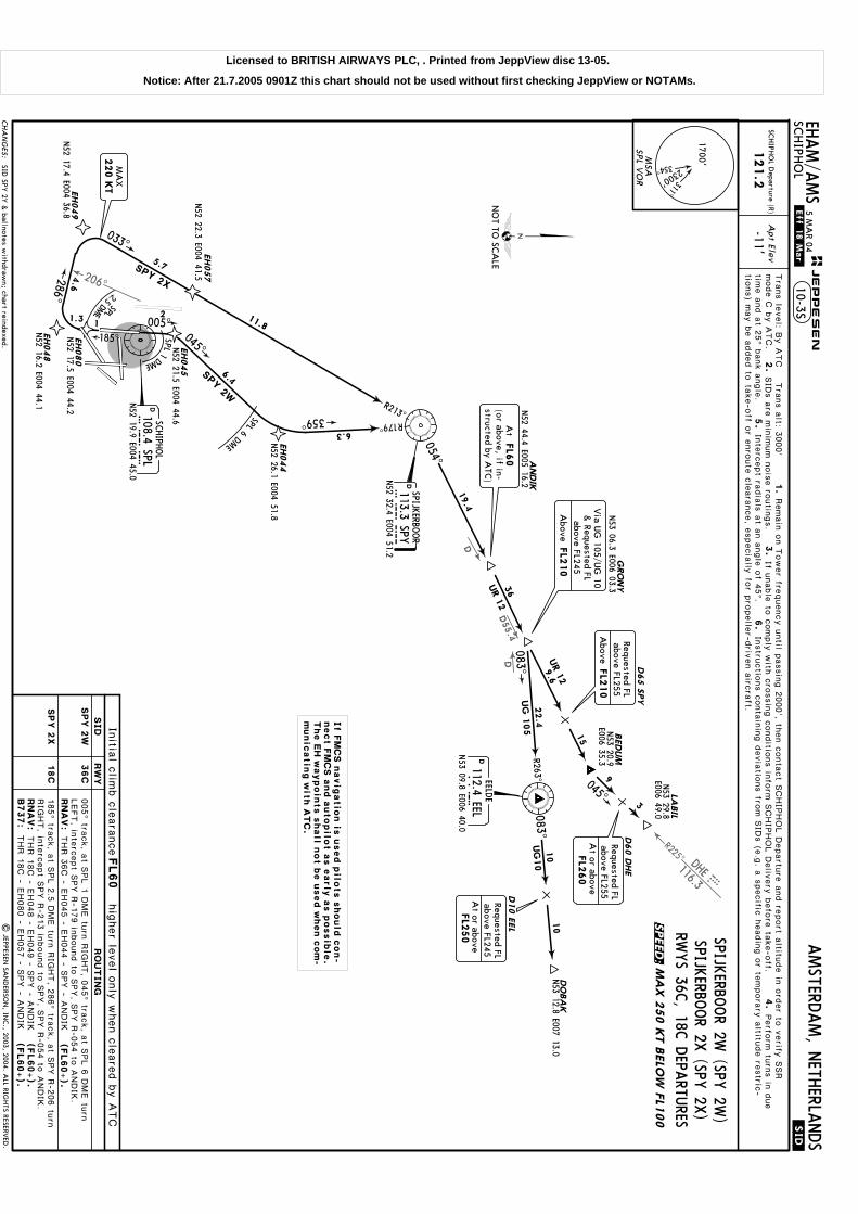
DD55.4
R225^ DHE116.3E
206^
D
DH
Apt Elev
-11'SC
HIPH
OL D
eparture (R)
121.2
RN
AV
:
D108.4 SPLSP
LN52 19.9 E004 45.0
SCHIPH
OL
SPIJKERBO
OR 2W
(SPY 2W
)SPIJK
ERBOOR 2X
(SPY 2X
)
DEELD
E
112.4 EELEEL
N53 09.8 E006 40.0
286^
033^
EH049
N52 17.4 E004 36.8
SPY 2X
EH057
054^
R213^
19.4
D113.3 SPYSP
YN52 32.4 E004 51.2
SPIJKERBO
OR
THR 1
8C - E
H048 - E
H049 - S
PY - A
NDIK
B737:
THR 1
8C - E
H080 - E
H057 - S
PY - A
NDIK
RWYS 36C
, 18C D
EPARTU
RES
EH080
N52 17.5 E004 44.2
EH048
N52 16.2 E004 44.1
2.5
DME
SPL
185^
EH044
N52 26.1 E004 51.8
R179^
SPY 2W
359^SPL6DME
045^
N52 22.3 E004 41.5
SPL1
DME
005^
EH045
N52 21.5 E004 44.6
RN
AV
:THR 3
6C - E
H045 - E
H044 - S
PY - A
NDIK
185^ tra
ck, a
t SPL 2
.5 D
ME tu
rn R
IGHT, 2
86^ tra
ck, a
t SPY R
-206 tu
rnRIG
HT, in
terc
ept S
PY R
-213 in
bound to
SPY, S
PY R
-054 to
ANDIK
.
005^ tra
ck, a
t SPL 1
DME tu
rn R
IGHT, 0
45^ tra
ck, a
t SPL 6
DME tu
rnLEFT, in
terc
ept S
PY R
-179 in
bound to
SPY, S
PY R
-054 to
ANDIK
.
Tra
ns le
vel: B
y A
TC T
rans a
lt: 3000'
1.
2.
SID
s a
re m
inim
um n
ois
e ro
utin
gs.
3.
4.
5.
Inte
rcept ra
dia
ls a
t an a
ngle
of 4
5^.
6.
If unable
to c
omply
with
cro
ssin
g c
onditio
ns in
form
SCHIP
HOL D
eliv
ery
befo
re ta
ke-o
ff.mode C
by A
TC.
Remain
on T
ower fre
quency u
ntil p
assin
g 2
000', th
en c
onta
ct S
CHIP
HOL D
epartu
re a
nd re
port a
ltitude in
ord
er to
verify
SSR
Perfo
rm tu
rns in
due
time a
nd a
t 25^ b
ank a
ngle
.In
stru
ctio
ns c
onta
inin
g d
evia
tions fro
m S
IDs (e
.g. a
specific
headin
g o
r tempora
ry a
ltitude re
stric
-
6.3
1
6.4
11.8
5.7
4.6
1.3 2
(FL60+).
(FL60+).
(FL60+).
MSA
1700'
2300' 311^
354^
SPL V
OR
RW
YSID In
itial c
limb c
leara
nce
FL60
hig
her le
vel o
nly
when c
leare
d b
y A
TC
CHA
NG
ES:
JEPPESEN
.Eff.18.Mar.
.SID.
EHAM/A
MS
AMSTERD
AM, N
ETHERLA
NDS
SCHIPH
OL
5 MA
R 0410-3S
NO
T TO SC
ALE
MA
X 2
50 K
T B
ELO
W F
L100
BEDUM
GRO
NY
N53 06.3 E006 03.3
D65 S
PY
D60 D
HE
D10 E
EL
9
3
36
R263^
083^
083^10
10
UG
10
UG
105
UR 1
2
045^
N53 12.8 E007 13.0
N53 20.9
E006 35.3
ANDIK
N52 44.4 E005 16.2
UR 1
2DO
BA
K
LABIL
N53 29.8
E006 49.0
9.6
22.4
FL2
50
At or above
Requested FLabove FL245
FL2
60
At or above
Requested FLabove FL255
FL2
10
Requested FLabove FL255
Above
At
FL6
0(or above, if in-structed by A
TC)
FL2
10
above FL245
Above
& Requested FL
Via U
G 105/U
G 10
220 K
TM
AX
SPY
2W
SPY
2X
36C
18C
If F
MC
S n
avig
atio
n is
used p
ilots s
hould
con-
nect F
MC
S a
nd a
utopilo
t a
s e
arly
as p
ossib
le.
The E
H w
aypoin
ts s
hall n
ot b
e u
sed w
hen c
om
-m
unic
atin
g w
ith A
TC
.
| JEPPESEN
SAN
DERSO
N, IN
C., 2003, 2004. A
LL RIGHTS RESERV
ED.
tions) m
ay b
e a
dded to
take-o
ff or e
nro
ute
cle
ara
nce, e
specia
lly fo
r pro
pelle
r-driv
en a
ircra
ft.
15
SID SPY
2Y &
ballnotes withdraw
n; chart reindexed.
RO
UTIN
G
SPEED:
Licensed to BRITISH AIRWAYS PLC, . Printed from JeppView disc 13-05.
Notice: After 21.7.2005 0901Z this chart should not be used without first checking JeppView or NOTAMs.

D48.9
253^
018^
165^
PROHIB
ITEDA
REAEH
(P)-26
PROHIB
ITEDA
REAEH
(P)-27
PROHIB
ITEDA
REAEH
(P)-28
Apt Elev
-11'SC
HIPH
OL D
eparture (R)
121.2
RN
AV
:
185^ tra
ck, a
t500'(500')
RN
AV
:
VA
LKO
N52 04.3 E003 50.4
D108.4 SPLSP
LN52 19.9 E004 45.0
SCHIPH
OL
DPA
MPU
S117.8 PA
MP
AMN52 20.1 E005 05.5
EH009
CH
SCHIPH
OL
N52 13.2 E004 33.5
ABEA
M C
H388.5 C
H
N52 13.4 E004 33.3
185^
D110.4 RTMR
TMN51 58.4 E004 28.9
ROTTERD
AM
N52 12.9 E004 35.8
VA
LKO
2E
VA
LKO
1G
4
284^EH029
N52 11.3 E004 49.2
EH062
N52 13.7 E004 48.0
D6.5
SPL
N52 15.6
E004 43.5
223^
RWYS 18L, 22 D
EPARTU
RESFO
R SIDS RW
YS 09, 24, 18C
THR 1
8L -
223^ tra
ck, in
terc
ept P
AM R
-253 to
VALKO.
VALK
O 2E
[VA
LK2E]
VALK
O 1G
[VA
LK1G
]
REFER TO C
HART 10-3U
turn
LEFT, in
terc
ept S
PL R
-165, a
t D6.5
SPL tu
rnRIG
HT, in
terc
ept 2
84^ b
earin
g to
ward
s C
H, a
t RTM R
-018 tu
rn L
EFT,
inte
rcept P
AM R
-253 to
VALKO.
Tra
ns le
vel: B
y A
TC T
rans a
lt: 3000'
1.
2.
SID
s a
re m
inim
um n
ois
e ro
utin
gs.
3.
4.
5.
Inte
rcept ra
dia
ls a
t an a
ngle
of 4
5^.
6.
If unable
to c
omply
with
cro
ssin
g c
onditio
ns in
form
SCHIP
HOL D
eliv
ery
befo
re ta
ke-o
ff.mode C
by A
TC.
Remain
on T
ower fre
quency u
ntil p
assin
g 2
000', th
en c
onta
ct S
CHIP
HOL D
epartu
re a
nd re
port a
ltitude in
ord
er to
verify
SSR
Perfo
rm tu
rns in
due
time a
nd a
t 25^ b
ank a
ngle
.In
stru
ctio
ns c
onta
inin
g d
evia
tions fro
m S
IDs (e
.g. a
specific
headin
g o
r tempora
ry a
ltitude re
stric
-
4
6.6
8.4
1.6
1.5
28
- EH029 (K
220-) - E
H009
(3000'+
) -
VALKO
(FL60+).
THR 2
2 - E
H062 - E
H009
(3000'+
) -
VALKO
(FL60+).
MSA
1700'
2300' 311^
354^
SPL V
OR
.SID.
JEPPESEN
.Eff.18.Mar. EH
AM/A
MS
AMSTERD
AM, N
ETHERLA
NDS
SCHIPH
OL
10-3T5 M
AR 04
RW
YSID
Initia
l clim
b c
leara
nce
FL60
hig
her le
vel o
nly
when c
leare
d b
y A
TC
CHA
NG
ES:
At
FL6
0(or above, if in-structed by A
TC)
VA
LK
O 2
E
VA
LK
O 1
G22
18L
NO
T TO SC
ALE
MA
X 2
50 K
T B
ELO
W F
L100
3000'
Above
220 K
TM
AX
At
500'
If F
MC
S n
avig
atio
n is
used p
ilots s
hould
con-
nect F
MC
S a
nd a
utopilo
t a
s e
arly
as p
ossib
le.
The E
H w
aypoin
ts s
hall n
ot b
e u
sed w
hen c
om
-m
unic
atin
g w
ith A
TC
.
| JEPPESEN
SAN
DERSO
N, IN
C., 2003, 2004. A
LL RIGHTS RESERV
ED.
Prohibited areas added; chart reindexed.
tions) m
ay b
e a
dded to
take-o
ff or e
nro
ute
cle
ara
nce, e
specia
lly fo
r pro
pelle
r-driv
en a
ircra
ft.
RO
UTIN
G
220 K
TM
AX
SPEED:
Licensed to BRITISH AIRWAYS PLC, . Printed from JeppView disc 13-05.
Notice: After 21.7.2005 0901Z this chart should not be used without first checking JeppView or NOTAMs.

PROHIB
ITEDA
REAEH
(P)-26
PROHIB
ITEDA
REAEH
(P)-27
241^
R036^
D48.9
253^
PROHIB
ITEDA
REAEH
(P)-28
Apt Elev
-11'SC
HIPH
OL D
eparture (R)
121.2
RN
AV
:
RN
AV
:
089^ tra
ck, a
t500'
(500')
RN
AV
:
[VA
LK1N
]VALK
O 1N
VALK
O 1S
[VA
LK1S]
VALK
O 2X
[VA
LK2X]
RWYS 09, 24, 18C
DEPA
RTURES
VA
LKO
N52 04.3 E003 50.4
EH040
N52 06.4 E004 28.1
N52 07.4 E004 30.5
D25 P
AM
267^
216^
EH025
N52 12.4 E004 44.4
VALKO 1
N
EH030
4
D108.4 SPLSP
LN52 19.9 E004 45.0
SCHIPH
OL
DPA
MPU
S
117.8 PAM
PAM
N52 20.1 E005 05.5
EH009C
HSC
HIPH
OL
N52 13.2 E004 33.5
ABEA
M C
H
388.5 CH
N52 13.4 E004 33.3
EH051
EH001
N52 16.5 E004 42.1
N52 14.6
E004 39.1 6
226^
235^
240^
185^
2.5 DME
4 DME
VA
LK
O 2
X
VA
LK
O 1
S
THR 0
9 -
THR 1
8C -
(500')
- EH051 - V
ALKO
D110.4 RTMR
TMN51 58.4 E004 28.9
ROTTERD
AM
089^
.Eff.18.Mar.
turn
RIG
HT, in
terc
ept R
TM R
-036 in
bound, in
ter-
cept P
AM R
-241, a
t D25 P
AM tu
rn R
IGHT, 2
67^ tra
ck to
VALKO.
- EH030 (K
220-) - E
H025 - E
H040 - V
ALKO
240^ tra
ck, a
t SPL 4
DME tu
rn L
EFT, 2
26^ tra
ck, in
terc
ept P
AM R
-253
to V
ALKO.
185^ tra
ck, a
t SPL 2
.5 D
ME tu
rn R
IGHT, 2
35^ tra
ck, in
terc
ept P
AM
R-2
53 to
VALKO.
Tra
ns le
vel: B
y A
TC T
rans a
lt: 3000'
1.
2.
SID
s a
re m
inim
um n
ois
e ro
utin
gs.
3.
4.
5.
Inte
rcept ra
dia
ls a
t an a
ngle
of 4
5^.
6.
If unable
to c
omply
with
cro
ssin
g c
onditio
ns in
form
SCHIP
HOL D
eliv
ery
befo
re ta
ke-o
ff.mode C
by A
TC.
Remain
on T
ower fre
quency u
ntil p
assin
g 2
000', th
en c
onta
ct S
CHIP
HOL D
epartu
re a
nd re
port a
ltitude in
ord
er to
verify
SSR
Perfo
rm tu
rns in
due
time a
nd a
t 25^ b
ank a
ngle
.In
stru
ctio
ns c
onta
inin
g d
evia
tions fro
m S
IDs (e
.g. a
specific
headin
g o
r tempora
ry a
ltitude re
stric
-
4
3.8
2
2.6
9.9
28
23.3
1.8
(FL60+).
VALKO
THR 2
4 - E
H001 - E
H051 - E
H009
(3000'+
) -
(FL60+).
(FL60+).
N52 15.7 E004 48.1
MSA
1700'
2300' 311^
354^
SPL V
OR
RW
YSID In
itial c
limb c
leara
nceFL60
hig
her le
vel o
nly
when c
leare
d b
y A
TC
CHA
NG
ES:
JEPPESEN
.SID.
EHAM/A
MS
AMSTERD
AM, N
ETHERLA
NDS
SCHIPH
OL
10-3U
NO
T TO SC
ALE
MA
X 2
50 K
T B
ELO
W F
L100
18C
At
FL6
0(or above, if in-structed by A
TC)
220 K
TM
AX
At
500'
3000'
Above
At
500'
RNA
V only
VA
LK
O 1
N09
VA
LK
O 1
S24
VA
LK
O 2
X
If F
MC
S n
avig
atio
n is
used p
ilots s
hould
con-
nect F
MC
S a
nd a
utopilo
t a
s e
arly
as p
ossib
le.
The E
H w
aypoin
ts s
hall n
ot b
e u
sed w
hen c
om
-m
unic
atin
g w
ith A
TC
.
5 MA
R 04
Prohibited area EH(P)-28 added; chart reindexed.
| JEPPESEN
SAN
DERSO
N, IN
C., 2003, 2004. A
LL RIGHTS RESERV
ED.
tions) m
ay b
e a
dded to
take-o
ff or e
nro
ute
cle
ara
nce, e
specia
lly fo
r pro
pelle
r-driv
en a
ircra
ft.
RO
UTIN
G
220 K
TM
AX
SPEED:
Licensed to BRITISH AIRWAYS PLC, . Printed from JeppView disc 13-05.
Notice: After 21.7.2005 0901Z this chart should not be used without first checking JeppView or NOTAMs.

Treesup to
Treesup to
Treesup to
RUN
-UP
AREA
Treesup to
FO
RPA
RKIN
G
PO
SIT
IONS
SEE 1
0-9
C
Shipsup to
CA
UTIO
N:
NO
ENTRY
totw
y W4 from
twys A
, B &
W.
NO
ENTRY
totw
ys E1 & N
9from
twys A
& B
.
Shipsup to
Stopway
328' 100m
6
6
LEGEN
D
H4
Taxiway
Hangar
De-icing area
80'
121.7G
round
W1
N5
W7
S
S2
G7 G
6
G
G5
G
G
G5
G4
G4
G
G3
G2
G1
G2
S2
Ramp
DA9
5
G
47'
49'
A24
4
Apt Elev
122.2121.97SCHIPHOL Delivery
131.35Channel 9GroundTowerDeparture
119.05 121.2 118.07XStart-up
52-1752-17
52-1852-18
52-20
52-20
52-2152-21
52-2252-22
04-43
04-43
04-44
04-44
04-45
04-45
04-46
04-46
04-47
04-47
04-48
04-48
04-49
04-49
121.7 121.8 121.9
| JEPPESEN SANDERSON, INC., 2002, 2005. ALL RIGHTS RESERVED.
5
5
4
V1
V2
V3V4
V
V
P7
P6
04-43
121.8G
round
52-19
52-19.9
52-19.8
52-19.7 04-42.904-43.1
04-4304-42.8
04-43.2
121.9G
round
121.65
A25
A26
A27
Z
A
Z
-12'Elev
W9Z1
Z1
10,827'
W5
W6
S
A1 A2A
TERM
INA
L
P4 P5119.22 118.1 118.27
04-43
RWY 18C/36CW7
A25
A26
A27Z
A
W8
W9
Z1
Z1
W6
Z
04-44
52-18
04-44.2
04-44.5
S
D-ATIS Departure
Pilot of arriving acft vacating the landing rwy
shall contact Schiphol Ground im
mediately.
FREQUEN
CY
121.8121.7121.8121.8121.8121.9
LAN
DIN
G RW
Y04/2206/2409/27
18L/36R18C
/36C18R
ACARS:
DCL
24 JUN 05.Eff.7.Jul.
For A
IRPO
RT B
RIE
FIN
G re
fer to
10-1
P p
ages
Communications. Notes transferred to 10-1P pages. Var. Rwy bearings. Construction area.
01^W
GA
P6 P6B
P6A
P7 P7B
P7A
VV
VVS
VS
VS
V4
VN
VE
FO
RPA
RKIN
G P
OSIT
IONS
SEE 1
0-9
C
FO
RPA
RKIN
G P
OSIT
IONS
SEE 1
0-9
C
CA
UTIO
N: D
o notm
istake highway
for runway.
FO
R A
DDIT
IONA
LIN
FO
RM
ATIO
N &
PA
RKIN
G P
OSIT
IONS
SEE 1
0-9
B
Pilots are strongly requested after havingobtained &
read back the enroute clearanceto sw
itch w/o A
TC instructions to
SCHIPH
OL Start-up.
Information about expected RW
Y com
binationrelated to SID
s, during peak hours, isbroadcasted on this freq.
Pilots may expect instructions to change
frequency when crossing the boundary betw
eenthe three areas of responsibility of SC
HIPH
OL
Ground. Pilots shall not change frequency
without A
TC instructions.
ARP
36R004^
18L184^
18C184^
22222^
06059^
24239^
09088^
272 68^
6608'2014m
1 5 4'6 2'
3 9 '
3300m
W4
Elev-11'
11,483'
3500mS3
S4S5
N2
E4
E2E1
Elev-12'
3400m11,155'
Elev-12'
Elev-12'
Elev-11'
Elev-11'
Elev-14'
ElevElev
-13'-11'
H5
H9
H10
H12
1 0 1 ' 64 '
Control
45'
A8
A7
A6
A5
A4
A2
A9
A13
A12
H14
GA
1
R
E
3 20 '
A20
VO
R
E5
W3
W2
65 '3 9'
H4
1 12 '
5 3 '
S6
S1
40 '
62 '
48 '
4 7 '
M
67 '
3
J
A22
D
3
WB
A
B A3
A3
A2B A2C A2D
S7 BA A10
A11 A
E3
BBA
N2
042^
04
E5
E4
E3
E4
N1
E GA
R
11,329'345
3m
N4
A15A
14
BA
16A
17A
18A
19A19GH
73 '
7 3 '
N9
N3
2
-11'SCHIPHOL 10-9AMSTERDAM, NETHERLANDS
(BELOW SEA LEVEL)N52 18.5 E004 45.9
CHANGES:
2
VO
R
EHAM/AMS
1
1
1 8 3'
18R184^
Elev-13'
Elev-12'36L
004^
3800m12,467'
6 7'5 6'
3 9 '
3
Control
Tower-W
est
Tower-
Center
VK
VL
VM
VK
3
A21Y
B
Feet
Meters
00
1000
1000
20003000
40005000
1500500
JEPPESEN
36C004^
B
P5
P4
P5B
P5A
P4A
P4B
Y
Limited m
ax wingspan
for entry apron viatw
y G2 171'/52m
.
H11
W8
Licensed to BR
ITISH A
IRW
AYS PLC
, . Printed from JeppView
disc 13-05.N
otice: After 21.7.2005 0901Z this chart should not be used w
ithout first checking JeppView or N
OTA
Ms.

10-9A3
| JEPPESEN
SAN
DERSO
N, IN
C., 2005. A
LL RIGHTS RESERV
ED.
New
temporary chart.
14 JAN
05
52-18.6
52-18.7
52-18.8
52-18.6
REFER A
LSO
TO
CHA
RT N
OTA
MS
WO
RK IN
PRO
GRESS O
N H
-APRO
N
52-18.7
52-18.8
SCHIPH
OL
CHA
NG
ES:
JEPPESEN
EHAM/A
MS
AMSTERD
AM, N
ETHERLA
NDS
Taxiway
G3+
G9
Blast fence
LEGEN
D
04-45.404-45.2
A
A
A19
G71+
G74+
G75+
G76+
G77
G78
G79
G72+
G73+G
70+H76+
H75+
A19
G9G
3+
G7+
G5+
A
G80
04-45.1
INS C
OO
RDIN
ATES
STA
ND N
o.
CO
ORDIN
ATES
G3, G
5G
7, G9
G70 thru G
74G
75 thru G80
H75, H
76
N52 18.7 E004 45.4
N52 18.8 E004 45.4
N52 18.7 E004 45.2
N52 18.8 E004 45.2
N52 18.7 E004 45.2
04-45.104-45.2
04-45.404-45.3
Working area
G-A
PRO
N
H-A
PRO
N
Parking stand
Push-pull stand
G-PIER
Licensed to BR
ITISH A
IRW
AYS PLC
, . Printed from JeppView
disc 13-05.N
otice: After 21.7.2005 0901Z this chart should not be used w
ithout first checking JeppView or N
OTA
Ms.

(30m
)(1
5m
)
(50m
)
(50m
)
(30m
)(1
5m
)
(30m
)(1
5m
)
(30m
)(1
5m
)
(30m
)(1
5m
)
(30m
)(1
5m
)
(30m
)(1
5m
)
(30m
)(1
5m
)
For normal operations LD
A 9268' (2825m
).In exceptional cases the additional pavem
entof sufficient strength of 1887' (575m
) beyond the red rw
y lights is available on request.
| JEPPESEN
SAN
DERSO
N, IN
C., 1998, 2005. A
LL RIGHTS RESERV
ED.
Restricted to landing acft with A
UW
76 tons and departing acft with A
UW
90 tons.
TAKE-O
FF
ABCD
RCLM
(DA
Y only)
250m
300m
400
m500
m
NIL
(DA
Y only)
1
1
RCLM
(DA
Y only)
RL & C
L
200m
250m
& m
ult. RVR req
125m
150m
LVP m
ust b
e in
Forc
e
or RLor RL
& m
ult. RVR req
150m
200m
RL, CL
HIRL, C
L
Operators applying U
.S. Ops Specs: C
L required below 300m
; approved guidance system required
below 150m
.
Approved
Operators
LVP m
ust
be in
Forc
e
EHAM/A
MS
(60m
)(1
5m
)
(60m
)(1
5m
)
Rw
ys 0
6, 0
9, 1
8L/
C, 2
4, 2
7, 3
6L/
C/R
All R
wys (e
xcept R
wy 1
8R)
24 JUN
05.Eff.7.Jul.
Notes transferred to 10-1P pages. U
sable lengths rwy 04/22.
SCHIPH
OL
18C36C
18L36R
0422
0624
0927
RVR
RVR
RVR
RVR
RVR
RVR
RVR
RVR
148'
148'
148'
148'
148'
45m
45m
45m
45m
45m
10-9A
Rwy 36R: N
et climb grad m
im 5%
until reaching 150'.
9756'2973m
9582'2920m
10,378' 3163m
59268'2
825m
8220'2505m
9268'2825m
9350'2850m
8280'2524m
RVR
RVR
5757'1755m
AMSTERD
AM, N
ETHERLA
NDS
HIRL C
LHIRL C
L
HIRL C
LPA
PI (3.0^)HIRL C
LTA
KE-O
FF RUN
AVA
ILABLE
6 3 2
4
4
3250m
10,663'
CHA
NG
ES:
JEPPESEN
11
RWY 06:
.JAR-OPS.
RWY
AD
DITIO
NA
L RUN
WA
Y IN
FORM
ATIO
N
ThresholdLA
ND
ING
BEY
ON
DUSA
BLE LEN
GTH
S
WID
THTA
KE-O
FFG
lide SlopeM
IRLM
IRLM
IALS PA
PI-L (3.0^)M
IALS
11,483' (3500m)
8530' (2600m)
From rw
y headtw
y S1 intFrom
rwy head
twy S7 int
twy S6 int
twy S5 int
twy S4 int
twy S3 int
11,483' (3500m)
11,319' (3450m)
10,663' (3250m)
10,663' (3250m)
8530' (2600m)
6398' (1950m)
2
TAKE-O
FF RUN
AVA
ILABLE
RWY 09:
3
From rw
y headtw
y N4 int
twy N
3 inttw
y N2 int
11,266' (3434m)
7874' (2400m)
6070' (1850m)
4429' (1350m)
TAKE-O
FF RUN
AVA
ILABLE
RWY 18L:
5
From rw
y headtw
y E5 inttw
y E4 inttw
y E2 int
11,155' (3400m)
9186' (2800m)
8366' (2550m)
6890' (2100m)
TAKE-O
FF RUN
AVA
ILABLE
RWY 18C
:RW
Y 36C
:6
HIRL
CL
HIRL
CL
10,827' (3300m)
8694' (2650m)
6726' (2050m)
From rw
y headtw
y W2 int
twy W
3 int
18R36LRV
RRV
R197'60m
3211m
7
TAKE-O
FF RUN
AVA
ILABLE
RWY 36L:
7
HIRL
CL
HIRL
CL
HIRL
CL
HIRL
CL
From rw
y headtw
y V3 int
twy V
2 inttw
y V1 int
12,467' (3800m)
10,679' (3255m)
9039' (2755m)
7070' (2155m)
3530m
11,581'10,535'
NA
NA
RWY 24:
Line-up for take-off rwy 24 via rw
y18L/36R prohibited.
From rw
y headtw
y W9 int
twy W
6 inttw
y W5 int
10,827' (3300m)
9793' (2985m)
8694' (2650m)
6890' (2100m)
HIA
LS-II TDZ PA
PI-L(3.0^)HST
HIA
LS-II TDZ PA
PI-L(3.0^)HST
HIA
LS-II TDZ PA
PI-L(3.0^)HST
HIA
LS-II TDZ PA
PI-L(3.0^)HST
HIA
LS-II TDZ PA
PI-L(3.0^)
HIA
LS-II TDZ PA
PI-L(3.0^)
3363m
11,033'11,230' 3
423m
Licensed to BRITISH AIRWAYS PLC, . Printed from JeppView disc 13-05.
Notice: After 21.7.2005 0901Z this chart should not be used without first checking JeppView or NOTAMs.

04-45.604-45.4
H71
H72+
H73
H74+
H75
H76
52-18.6
04-45.5
04-45.804-45.7
B-A
PRON
TERM
INA
L
FREIG
HT
II & III
FREIG
HT I
04-46.104-46.2
04-46.604-46.3
24 JUN 05.Eff.7.Jul.
04-46.404-46
04-46.104-46.2
04-46.304-46.5
AMSTERDAM, NETHERLANDSSCHIPHOL
CHANGES:
EHAM/AMS
| JEPPESEN SANDERSON, INC., 1998, 2005. ALL RIGHTS RESERVED.
MA
X w
ingspan:
JEPPESEN
10-9B
213'/65m171'/52m157'/48m118'/36m98'/30m95'/29m
Chart reindexed. Wingspan restriction. Notes transferred to 10-1P pages.
the push-back truck)A
5Taxiw
ayF6+
Push-pull
RWY 09/27
A15
A16
A17
A18
04-45.404-45.3
E18+
F8F9
F3
F5G
6
G8
G71
F7G
9
A19
G74
G75G
76
G77
G78G
79
G80
A14
D88
D90
D93
D94
D95
D92
52-19
E19
E72E75
E77
G72 G
73
E24
E22
G3+
G7+
G5+
G4+
G2+
F6+
F4+
F2+
E2+
E4+
E6+
E8+
E3+ E5+ E7+ E9+
E17+
BA
BA
A17
A16
A14
B
A
N4
N3
N9
N2
E5
E4
E3
A11
04-45.2
G-APRON
H-APRO
N
E-A
PRO
N
D-A
PRO
N
A19
E20
A4
C14
C16
C18
A2
52-18
B15
B51
B52
B53
B54
B55
B85
B94
B95
B13
B10B
12
S3
A
A4W
4
A
B
6
6
6A
1
A2A
A2B
A2C
A2D
Right turn (as seen from
the push-back truck)D
16C5
Blast fence
LEGEN
D
Parking position
D42
B85
Taxi-in/taxi-out
A8
C5
2A
8A
5
D4
D3
A7
C13
C11
C9
C7
C12
52-18.3B11
E1
A
2A
6
C4C
6
C8
C10
B09
A4E
B48
B45
B46
B43B
42B41
B35
B33
B31
Control
Tower
-Center
Com
pulsory taxi routing
B84B
83B82B
81
B66B
65B64B
63B62B
61
B71
B72
B73
B74
B75
B76
B34+B
32+
B56+
B47+B
44+
A12
A13
P3
P2
P1
52-18.9
A13
A13
A
A12
B
RWY 06/24
A5
S6
Left turn (as seen fromStraight backw
ardsD
14
A6
S7
S5
Standard push-back directions:
B
A10
D5D8
D41
DD
D
DD
DD
D47
4953
55D
57A
D57B
51B
D51A
D43
E2
A10
A10
AB
2
2
Limit of
Ground
Control
Com
petence
A9
D42
D7
4446
4852
5456
5A
9N
A9S
DD
D
D12D
14
D16
D18
D22
D24
D26
D28
D31
D29
D27
D25
D23
D21
D19
D10
5
A5
52-18.2
B17B
19
B91
B92
B93
B14
B18
S4
4
A
B
A3
3
6
A3
1
1
1
1
1
123456
52-19
04-45.504-45.8
ARP
RWY 24
RWY 18L/36R
NOENTRY
B-CORRID
OR
De-icingareaP-HOLDING
CA
UTIO
N: N
O EN
TRY to
twy E1 from
twys A
& B
.
E1
S7
E-PIER
F-PIER
G-PIER
B-PIER
C-PIER
D-P
IER
Licensed to BR
ITISH A
IRW
AYS PLC
, . Printed from JeppView
disc 13-05.N
otice: After 21.7.2005 0901Z this chart should not be used w
ithout first checking JeppView or N
OTA
Ms.
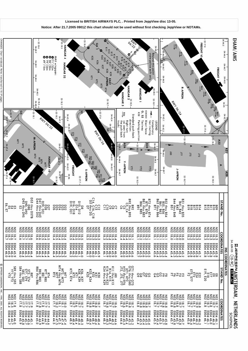
AMSTERD
AM, N
ETHERLA
NDS
SCHIPH
OL
10-9C
R80
04-44.5
FREIG
HT V
I
04-44.604-44.7
52-18.8
52-18.7
52-18.8
52-18.7
J72
J75
J77
J80
A21
A
EHAM/A
MS
| JEPPESEN
SAN
DERSO
N, IN
C., 1998, 2005. A
LL RIGHTS RESERV
ED.
A22
A
A20
52-18.1
04-47.3
RWY 04/22
M71 M
72
M73
M74 M
75M
76 M77
G
G5 52-18.2
M-A
PRO
N
52-18.3
04-44.6
04-44.7
A
04-44.7
52-18.3
04-44.6Y-A
PRO
N
Y71
Y72
Y73
A26
A25
04-44.5
04-44.5
Standard push-backdirection:
S2
S72S74
S82 S83S84S85
S87S88 S89
S90S91
S92S93
S77S79
FREIG
HT V
S3
FREIG
HT
24 JUN
05.Eff.7.Jul.
04-45.7
04-45.7
Beyond this point
state police acft onlyEA
ST
APRO
N
INS C
OO
RDIN
ATES
CO
ORDIN
ATES
STA
ND N
o.
CHA
NG
ES:
HA
NG
AR 4
04/22
RWY
52-18.8
52-18.7
52-18.5
HA
NG
AR 1
HA
NG
AR 2
HA
NG
AR 3
HA
NG
AR 3
252-18.5
1
1
2
234
4
52-18.9
52-17.8
04-44.704-44.8
04-45.104-45.2
R72
R74
R77
R81
R82
R84R85 R86
R87
R83
04-4504-44.6
04-44.8
52-17.8
04-44.704-45.1
RWY 06/24
04-44.6
STA
ND N
o.
CO
ORDIN
ATES
S1
G1
G
52-18.6
52-18.452-18.4
GA
2
K11 K
12 K13 K
14 K15
04-48.304-48.4
04-48.6
3
K32K
33K34
GA
1
K19
K18
K17
K16
K23
K22
K21
K20
K35
K36
K37 K
38 K39
K72
K73 K
74
K24 K
25 K26 K
27 K28 K
29 K30 K
31
R
K71
JEPPESEN
04-48.204-48.5
04-48.204-48.5
04-47.204-47.4
04-47.204-47.4
HA
NG
AR 1
0
04-47.6
04-47.604-47.5
52-1852-18
52-18.2
LEGEN
D
R86Right turn(as seen fromthe push-backtruck)
RWY 06/24
04-45.404-45.5
04-46
04-45.404-45.5
04-45.804-45.9
52-17.7
52-17.8
04-45.804-45.9
B09
B10
B11
B12
B13
B14
B15
B17
B18
B19
B31 thru B
35B41, B
42B43
B44 thru B
48B51
B52 thru B
54B55, B
56B61, B
62B63 thru B
66B71
B72 thru B
74B75, B
76B81 thru B
83B84, B
85B91
B92
B93 thru B
95C3, C
4C5
C6 C7
C8
C9
C10
C11
C12
C13
C14, C
16, C18
D3 thru D
5D
7 D8
D10, D
12D
14D
16, D18
D19, D
21
D22
D23
D24
D25
D26
D27
D28
D29, D
31D
41 thru D43
D44 thru D
52
D53 thru D
57BD
88D
90, D92
D93 thru D
95E2 E3E4E5
E6, E7
N52 18.3 E004 45.8
N52 18.3 E004 45.7
N52 18.3 E004 45.8
N52 18.2 E004 45.7
N52 18.3 E004 45.8
N
52 18.2 E004 45.7N
52 18.3 E004 45.8N
52 18.2 E004 45.9N
52 18.2 E004 45.8N
52 18.2 E004 45.9
N52 18.0 E004 45.2
N52 18.0 E004 45.4
N52 18.0 E004 45.3
N52 18.1 E004 45.3
N52 18.0 E004 45.4
N
52 18.1 E004 45.4N
52 18.1 E004 45.3N
52 18.1 E004 45.5N
52 18.1 E004 45.4N
52 18.1 E004 45.6
N52 18.1 E004 45.5
N52 18.2 E004 45.5
N52 18.1 E004 45.6
N52 18.2 E004 45.5
N52 18.1 E004 45.7
N
52 18.1 E004 45.6N
52 18.2 E004 45.6N
52 18.4 E004 45.9N
52 18.4 E004 46.0N
52 18.4 E004 45.9
N52 18.4 E004 46.0
N52 18.3 E004 45.9
N52 18.4 E004 46.0
N52 18.3 E004 45.9
N52 18.3 E004 46.1
N
52 18.3 E004 45.9N
52 18.3 E004 46.1N
52 18.3 E004 46.0N
52 18.5 E004 46.0N
52 18.5 E004 46.1
N52 18.5 E004 46.0
N52 18.5 E004 46.1
N52 18.5 E004 46.2
N52 18.4 E004 46.2
N52 18.5 E004 46.2
N
52 18.4 E004 46.3N
52 18.5 E004 46.3N
52 18.4 E004 46.3N
52 18.5 E004 46.3N
52 18.4 E004 46.4
N52 18.5 E004 46.4
N52 18.4 E004 46.4
N52 18.5 E004 46.4
N52 18.6 E004 46.2
N52 18.6 E004 46.3
N
52 18.6 E004 46.4N
52 18.7 E004 46.2N
52 18.7 E004 46.3N
52 18.7 E004 46.4N
52 18.6 E004 46.0
N52 18.7 E004 45.9
N52 18.6 E004 46.0
N52 18.7 E004 45.9
N52 18.7 E004 46.0
E8E9E17 E18
E19, E20
E22E24E72
E75, E77F2 F3F4F5 F6F7 F8F9G
2 G
3G
4 G5
G6
G7
G8
G9
G71 thru G
75G
76 thru G80
H71, H
72 H73 thru H
76J72, J75, J77
J80
K11 thru K
13K14, K
15 K16 thru K
23K24 thru K
29
K30
K31
K32
K33, K
34K35
K36, K
37K38, K
39K71
K72
K73, K
74
M71
M72, M
73M
74 thru M76
M77
R72
R74R77, R80
R81R82, R83
R84 thru R86
R87S72, S74S77, S79 S82, S83
S84 thru S88
S89 thru S93 Y71, Y
72Y73
N52 18.7 E004 46.1
N52 18.7 E004 46.0
N52 18.8 E004 46.0
N52 18.7 E004 46.1
N52 18.8 E004 46.1
N
52 18.8 E004 46.2N
52 18.9 E004 46.2N
52 18.7 E004 46.3 N
52 18.7 E004 46.4N
52 18.7 E004 45.8
N52 18.7 E004 45.7
N52 18.7 E004 45.8
N52 18.8 E004 45.7
N52 18.8 E004 45.8
N52 18.8 E004 45.7
N
52 18.8 E004 45.8N
52 18.8 E004 45.7N
52 18.7 E004 45.5 N
52 18.7 E004 45.4N
52 18.7 E004 45.5
N52 18.7 E004 45.4
N52 18.8 E004 45.5
N52 18.8 E004 45.4
N52 18.8 E004 45.5
N52 18.8 E004 45.4
N
52 18.7 E004 45.2N
52 18.8 E004 45.2N
52 18.6 E004 45.4 N
52 18.6 E004 45.3N
52 18.7 E004 44.6
N52 18.6 E004 44.6
N52 18.7 E004 48.2
N52 18.7 E004 48.3
N52 18.8 E004 48.3
N52 18.7 E004 48.3
N
52 18.7 E004 48.4N
52 18.8 E004 48.4N
52 18.8 E004 48.3 N
52 18.8 E004 48.4N
52 18.6 E004 48.3
N52 18.7 E004 48.3
N52 18.7 E004 48.4
N52 18.6 E004 48.4
N52 18.7 E004 48.4
N52 18.7 E004 48.5
N
52 18.0 E004 47.4N
52 18.1 E004 47.4N
52 18.1 E004 47.5 N
52 18.2 E004 47.5N
52 17.7 E004 44.5
N52 17.7 E004 44.6
N52 17.7 E004 44.7
N52 17.8 E004 44.8
N52 17.8 E004 44.9
N52 17.8 E004 45.0
N
52 17.9 E004 45.1N
52 17.7 E004 45.6N
52 17.7 E004 45.7N
52 17.7 E004 45.8N
52 17.8 E004 45.9
N52 17.8 E004 46.0
N52 18.3 E004 44.7
N52 18.4 E004 44.7
Parking positionK38
Taxiway
G, S
2
Blast fence
Com
pulsory taxi routing
J-APRO
N
R-A
PRO
N
S-A
PRO
N
171'/52m98'/30m79'/24m49'/15m
MA
X w
ingspan:
Chart reindexed. N
otes transferred to 10-1P pages.
52-17.7
52-18.1
Licensed to BRITISH AIRWAYS PLC, . Printed from JeppView disc 13-05.
Notice: After 21.7.2005 0901Z this chart should not be used without first checking JeppView or NOTAMs.

B737
.
12 354
Do n
ot u
se th
e s
yste
m u
ntil:
- the g
reen p
air o
f lights
at th
e b
otto
m o
f the d
ispla
y a
re b
linkin
g (s
ee p
ara
A ite
m 4
).- th
e a
ircra
ft type is
shown (b
linkin
g) o
n th
e in
form
atio
n a
rea o
n to
p o
f the d
ispla
y (s
ee
para A item
3).The p
ilot s
hould
be a
ware
that th
e c
orre
ct ty
pe o
f airc
raft is
shown b
efo
re u
sin
g th
e s
yste
m.
| JEPPESEN
SAN
DERSO
N, IN
C., 1999, 2005. A
LL RIGHTS RESERV
ED.
EHAM/A
MS
24 JUN
05.Eff.7.Jul.
AMSTERD
AM, N
ETHERLA
NDS
SCHIPH
OL
10-9D
CHA
NG
ES:
JEPPESEN
VIS
UA
L DO
CKIN
G G
UID
ANCE S
YSTEM
(SA
FEDO
CK)
A. S
YSTEM
DESCRIP
TIO
N
E. D
ISPLA
Y IN
FO
RM
ATIO
N T
EXT
ERR
WA
IT
TO
O/FA
R
CHO
CK/O
NChocks a
re in
pla
ce.
B737
OK
STO
P
TEST/W
AIT
The a
ircra
ft has re
ached th
e s
toppin
g p
oin
t or th
e d
ockin
g p
rocedure
is n
ot
carrie
d o
ut c
orre
ctly
.
The c
hosen ty
pe o
f airc
raft d
urin
g th
e c
losin
g-in
is c
hanged b
y th
e o
pera
tor.
When th
e c
orre
ct ty
pe is
dis
pla
yed th
e p
ark
ing c
an b
e c
ontin
ued.
Park
ing is
corre
ct.
If a s
yste
m fa
ult o
ccurs
the d
ispla
y w
ill show "
ERR". T
he "
STOP"-s
ign w
ill be s
hown
as w
ell. T
he a
ircra
ft has to
be p
ark
ed b
y m
eans o
f eith
er m
ars
hallin
g o
r a tra
cto
r.
The to
plin
e o
n th
e d
ispla
y h
as o
ne o
r two in
form
atio
n lin
e(s
). Dependin
g o
n th
e n
umber o
favaila
ble
info
rmatio
n lin
es, th
e in
form
atio
n w
ill eith
er b
e s
hown o
n b
oth
lines o
r will b
eshown in
term
ittent in
two g
roups. T
he fo
llowin
g in
form
atio
n c
an b
e e
xpecte
d:
C. C
ENTERLIN
E G
UID
ANCE
Cente
rline g
uid
ance is
obta
ined b
y m
eans o
f (a) re
d a
rrow(s
) poin
ting a
t the v
ertic
al g
reen
cente
rline b
ar. T
he a
ircra
ft is o
n th
e c
ente
rline w
hen a
t the s
ame tim
e o
n b
oth
the le
ftand th
e rig
ht s
ide o
f the c
ente
rline b
ar a
red a
rrow a
ppears
. If the p
ositio
n o
f nose g
ear is
on th
e le
ft (or rig
ht) s
ide o
f the c
ente
rline th
e a
rrow a
ppears
on th
e le
ft (or rig
ht) s
ide o
fth
e c
ente
rline. If th
e d
evia
tion g
ets
extre
me a
double
arro
w w
ill appear.
D. C
LOSIN
G-R
ATE A
ND S
TO
P IN
FO
RM
ATIO
NFor e
ach ty
pe o
f airc
raft a
sto
ppoin
t has b
een a
ssig
ned w
ithin
the s
yste
m. C
losin
g ra
tein
form
atio
n is
giv
en o
ver th
e la
st 5
6'/
17m b
y m
eans o
f gre
en (firs
t 46'/
14m) a
nd y
ello
w(la
st 1
0'/
3m) lig
hts
. As s
oon a
s th
e re
set a
rea is
activ
ate
d th
e b
otto
m p
air o
f gre
en lig
hts
will s
how "
ste
ady". A
t the s
ame tim
e th
e g
reen c
ente
rline b
ar a
ppears
on th
e d
ispla
y. T
he
lights
will m
ove fro
m th
e b
otto
m s
ide o
f the d
ispla
y u
pward
s in
the d
irectio
n o
f the s
toppin
gpositio
n. W
hen th
e s
top-a
rea is
activ
ate
d th
e a
zim
uth
-guid
ance a
rrows w
ill be re
pla
ced b
yth
e w
ord
"STO
P"
1. V
ertic
al g
reen b
ar in
dic
atin
g th
e c
ente
rline.
5. G
reen o
r yello
w c
losin
g ra
te in
form
atio
n lig
hts
.
3. D
ispla
y in
form
atio
n (s
ee p
ara
E).
B. A
CTIV
ATED S
YSTEM
The s
yste
m is
opera
ted b
y a
n e
mplo
yee o
f a h
andlin
g c
ompany, w
ho a
lso k
eeps a
safe
tywatc
h d
urin
g th
e d
ockin
g. T
he p
ilot o
f an a
rrivin
g a
ircra
ft has to
be s
ure
that th
e s
yste
mis
activ
ate
d. If n
ot, th
e a
ircra
ft has to
sto
p s
hort a
nd w
ait u
ntil th
e s
yste
m is
switc
hed o
n,
or s
ignals
are
giv
en b
y a
mars
halle
r.
The s
yste
m c
onsis
ts o
f a d
ispla
y u
nit in
front o
f the p
ark
ing p
ositio
n a
nd a
laser u
nit
undern
eath
it. Due to
the d
igita
l dis
pla
y p
resenta
tion, b
oth
pilo
ts g
et th
e c
orre
ct a
lignment
info
rmatio
n a
s w
ell a
s th
e c
losin
g-ra
te a
nd s
top in
form
atio
n.
4. O
ne p
air o
f blin
kin
g g
reen lig
hts
indic
atin
g "
the s
yste
m is
ready fo
r use".
2. R
ed a
rrow(s
) poin
ting to
ward
s th
e c
ente
rline b
ar in
dic
atin
g th
edevia
tion fro
m th
e c
ente
rline. W
hen o
n c
ente
rline, tw
o re
dtria
ngle
s w
ill appear.
When th
e s
yste
m is
activ
ate
d th
e la
sers
yste
m c
arrie
s o
ut a
self-te
st b
efo
re th
e ty
pe
of a
ircra
ft appears
on th
e d
ispla
y.
The s
toppoin
t has b
een o
vers
hot b
y m
ore
than 3
'/1m: A
sk g
roundcre
w if
push-b
ack is
necessary
.
(as a
n e
xample
)The e
xpecte
d ty
pe o
f airc
raft is
shown.
1.
2.
3.
4.
5.
6.
7.
8.
Chart reindexed.
Licensed to BR
ITISH A
IRW
AYS PLC
, . Printed from JeppView
disc 13-05.N
otice: After 21.7.2005 0901Z this chart should not be used w
ithout first checking JeppView or N
OTA
Ms.
| JEPPESEN
SAN
DERSO
N, IN
C., 1998, 2005. A
LL RIGHTS RESERV
ED.
The s
yste
m is
opera
ted b
y a
n e
mplo
yee o
f a h
andlin
g c
ompany, w
ho a
lso k
eeps a
safe
tywatc
h d
urin
g th
e d
ockin
g. T
he p
ilot o
f an a
rrivin
g a
ircra
ft has to
be s
ure
that th
e s
yste
mis
activ
ate
d. If n
ot, th
e a
ircra
ft has to
sto
p s
hort a
nd h
as to
wait u
ntil th
e s
yste
m is
switc
hed o
n, o
r sig
nals
are
giv
en b
y a
mars
halle
r.
EHAM/A
MS
Cente
rline g
uid
ance is
obta
ined b
y m
eans o
f an
illumin
ate
d b
ar in
front
of a
n a
ircra
ft symbol.
The a
ircra
ft is o
n c
ente
r-lin
e w
hen b
ar a
nd s
ymbol
overla
p e
ach o
ther.
24 JUN
05.Eff.7.Jul.
VIS
UA
L DO
CKIN
G G
UID
ANCE S
YSTEM
(SA
FEG
ATE)
AMSTERD
AM, N
ETHERLA
NDS
SCHIPH
OL
10-9E
CHA
NG
ES:
JEPPESEN
(follo
win
g in
form
atio
n c
an b
e e
xpecte
d)
1.
2.
3.
4.
5.
6.
7.ERR
WA
IT
SBU
STO
P/SHO
RT
TO
O/FA
RCHO
CK/O
NPark
ing is
corre
ct
Chocks a
re in
pla
ce.
push-b
ack is
necessary
.
The s
topsig
n is
giv
en m
anually
. Taxi v
ery
care
fully
.If o
ne o
r more
sensors
are
mis
sed d
urin
g ta
xi-in
, this
info
rmatio
n is
giv
en to
geth
er
The ty
pe o
f airc
raft d
urin
g c
losin
g-in
is c
hanged. W
hen th
e c
orre
ct ty
pe is
dis
pla
yed th
e p
ark
ing c
an b
e c
ontin
ued.
0 a
nd 9
. The S
TOP-s
ign w
ill be s
hown a
s w
ell. T
he a
ircra
ft has to
be p
ark
ed
E. D
ISPLA
Y IN
FO
RM
ATIO
N T
EXT
by m
eans o
f eith
er m
ars
hallin
g o
r a tra
cto
r.
If a s
yste
m fa
ult o
ccurs
the d
ispla
y w
ill show th
is to
geth
er w
ith a
number b
etw
een
with
the n
orm
al S
TOP-s
ignal a
s s
oon a
s th
e c
hosen s
top-s
ensor is
activ
ate
d.
The s
yste
m is
opera
ted b
y a
n o
pera
tor; n
o c
losin
g-ra
te in
form
atio
n a
vaila
ble
.
OK !
C. C
ENTERLIN
E G
UID
ANCE
TURN
LEFTO
N C
ENTERLIN
ETU
RN RIG
HT
B. A
CTIV
ATED S
YSTEM
- the b
otto
m p
air o
f gre
en lig
hts
are
blin
kin
g
- the s
topbarlig
hts
are
shown
2. T
he p
ilot s
hould
be a
ware
that th
e c
orre
ct ty
pe o
f airc
raft is
shown b
efo
re u
sin
g th
esyste
m.
- the a
ircra
ft type is
shown (b
linkin
g) o
n th
e u
pper in
form
atio
n b
lock
1. D
o n
ot u
se th
e s
yste
m u
ntil:
A. S
YSTEM
DESCRIP
TIO
NThe s
yste
m c
onsis
ts o
f a d
ispla
y u
nit in
front o
f the p
ark
ing p
ositio
n a
nd a
number o
fsensors
in th
e a
pro
n s
urfa
ce.
as w
ell a
s th
e c
losin
g-ra
te a
nd s
top in
form
atio
n.
b. D
ispla
y in
dic
atin
g: S
TOP.
h. G
reen illu
min
ate
d c
ente
rline b
ar.
i. Pair o
f gre
en lig
hts
= D
ock is
ready fo
r park
ing.
c. T
wo p
airs
of re
d s
top in
form
atio
n lig
hts
.
d. P
air o
f gre
en lig
hts
indic
atin
g th
e "
sto
p"-b
ar.
a. D
ispla
y in
form
atio
n (E
xpla
natio
n g
iven u
nder p
ara
E).
On th
e d
ispla
y th
e le
ft-hand p
ilot g
ets
the c
orre
ct a
lignm
ent
e. T
hre
e p
airs
of y
ello
w c
losin
g-ra
te in
form
atio
n lig
hts
.
f. Nin
e p
airs
of g
reen c
losin
g-ra
te in
form
atio
n lig
hts
.
g. Y
ello
w illu
min
ate
d a
ircra
ft symbol.
Chart reindexed.
D. C
LOSIN
G-R
ATE A
ND S
TO
P IN
FO
RM
ATIO
NFor e
ach ty
pe o
f airc
raft a
sto
ppoin
t has b
een a
ssig
ned w
ithin
the s
yste
m. C
losin
g-ra
te
"STO
P"
When th
e s
top-s
ensor is
activ
ate
d th
e w
ord
and fo
ur re
d lig
hts
will b
e s
hown.
the b
otto
m p
air o
f gre
en lig
hts
and th
e ty
pe o
f airc
raft in
dic
atio
n a
t the to
p w
ill show "
ste
ady".
info
rmatio
n is
giv
en o
ver th
e la
st 4
0'/
12m b
y m
eans o
f nin
e p
airs
of g
reen a
nd th
ree p
airs
of
yello
w lig
hts
. As s
oon a
s th
e re
set lo
op (4
8'/
14.5
m in
front o
f the s
toppoin
t) is a
ctiv
ate
d
The s
toppoin
t has b
een o
vers
hot b
y m
ore
than 3
'/1m: a
sk g
roundcre
w if
Licensed to BR
ITISH A
IRW
AYS PLC
, . Printed from JeppView
disc 13-05.N
otice: After 21.7.2005 0901Z this chart should not be used w
ithout first checking JeppView or N
OTA
Ms.

| JEPPESEN
SAN
DERSO
N, IN
C., 1998, 2005. A
LL RIGHTS RESERV
ED.
EHAM/A
MS
24 JUN
05.Eff.7.Jul.
AMSTERD
AM, N
ETHERLA
NDS
SCHIPH
OL
10-9F
VIS
UA
L DO
CKIN
G G
UID
ANCE S
YSTEM
(AG
NIS
/PA
PA
)
A. S
YSTEM
DESCRIP
TIO
N
The s
yste
m is
calib
rate
d fo
r use
from th
e le
ft-hand c
ockpit s
eat.
YELLO
WTA
XI-LIN
E
GR
EEN
REDRED
INFO
RMA
TION
SYSTEM
STOP
AZIM
UTH
GUID
AN
CE
UN
IT
B. A
ZIM
UTH IN
FO
RM
ATIO
N (A
GNIS
)The a
zim
uth
guid
ance in
form
atio
n is
giv
en b
y m
eans o
f gre
en a
nd re
d b
ars
shown o
n th
e
unit in
front o
f the y
ello
w a
ircra
ft sta
nd ta
xi-lin
e.
REDG
REENG
REENG
REENG
REENRED
LEFT of centerline.Turn tow
ards GREEN
.(RIG
HT)
Aircraft on centerline.
RIGHT of centerline.
Turn towards G
REEN.
(LEFT)
C. S
TO
P IN
FO
RM
ATIO
N (P
APA
)
CHA
NG
ES:
JEPPESEN
STO
P
ALL
TYPES
STO
P
OTH
ERTY
PES146
STO
P
OTH
ERTY
PES
B757
B767-200
L1011-100TU
154
A310
A321
MD
80
YA
K42
EXAMPLE 1
EXAMPLE 2
EXAMPLE 3
E. O
PERA
TIO
NThe s
yste
m is
opera
ted b
y a
n e
mplo
yee o
f a h
andlin
g c
ompany, w
ho a
lso k
eeps a
safe
ty
watc
h d
urin
g th
e d
ockin
g. T
he p
ilot o
f an a
rrivin
g a
ircra
ft has to
be s
ure
that th
e s
yste
m
is a
ctiv
ate
d. If n
ot, th
e a
ircra
ft has to
sto
p s
hort a
nd h
as to
wait u
ntil th
e s
yste
m is
switc
hed o
n, o
r sig
nals
are
giv
en b
y a
mars
halle
r.
D. E
MERG
ENCY S
TO
PThe D
ockin
g g
uid
ance s
yste
m in
sta
lled h
as a
n e
merg
ency s
top-s
ign a
nd tw
o re
d
lights
pla
ced o
n to
p in
the c
ente
r and o
n th
e u
pper c
orn
ers
of th
e P
APA-b
oard
. When
"STO
P"
is s
hown a
nd th
e re
d lig
hts
are
lit inte
rmitte
nt, th
e a
ircra
ft has to
sto
pth
e w
ord
immedia
tely
. The e
merg
ency s
top-s
ign is
activ
ate
d b
y th
e s
uperv
isin
g o
pera
tor.
The s
yste
m c
onsis
ts o
f an A
zim
uth
guid
ance u
nit (A
GNIS
) and th
e s
top in
form
atio
nsyste
m (P
APA).
Sto
p in
form
atio
n is
giv
en b
y th
e P
APA-b
oard
positio
ned o
n th
e rig
ht o
r left s
ide o
f the
AGNIS
unit.
Chart reindexed. Text. Licensed to B
RITISH
AIR
WA
YS PLC, . Printed from
JeppView disc 13-05.
Notice: A
fter 21.7.2005 0901Z this chart should not be used without first checking JeppView
or NO
TAM
s.
Leiden
(Valkenburg)
EH(P)-26
MSA
SPL V
OR
Do not descend below
the descent profile.
No A
ltitudepublished
D0.0
D6.2
34.0 to VO
RFL 70
1
KA
G D3.9
KA
G
KA
G
SCHIPH
OL
108.4 SPLD
S P L
D0.0
TO D
ISPL THRESH
KA
G
D6.2
KA
G
Expedite climb to 2000'.
3
3
(IF)
MIS
SED A
PCH:
BRIEFING STRIP TM SCHIPH
OL
AMSTERD
AM, N
ETHERLA
NDS
LOC
059^
DA
(H)
188'(2
00')
Apt Elev
-11'RW
Y-1
2'
ALS out
Gnd speed-K
ts2000'
059^
on
Clim
b on track 059^ to 2000'. Inform A
TC.
11-1
PAPI
1
1
ILS
ALS out
FULL
70
90
100
120
140
160
EHAM/A
MS
121.7
SO
KSI 1
Apch
(By A
TC)
SOKSI 1 A
pch & ILS Rw
y 06
KA
G
110.5
5
EH6~
9
D3.9
KA
G
EH61
6
Alt Set: hPa
Rwy Elev: 0 hPa
Trans level: By A
TCTrans alt: 3000'
SCHIPH
OL
388.5 CH
C H
EH6~
9
EH61
6
52-10
52-20
04-2004-30
04-4004-50
SOKSI
EH613
EH614
059^ 3.0to D
6.2 KA
G
495'
GS
ILS DM
E
K A G
059^ 1
10.5
5 K
AG
05 5 10
Final
Apch C
rs
SCHIPH
OL A
pproach (R)G
roundSC
HIPH
OL Tow
erSC
HIPH
OL A
rrival (APP/R)
D-A
TIS Arrival
119.22 118.1 118.27119.05 121.2
108.4 132.97118.4 131.15
27 MA
Y 05
| JEPPESEN
SAN
DERSO
N, IN
C., 2003, 2005. A
LL RIGHTS RESERV
ED.
PANS OPS 4
During night hours interception
of 3.0^ descent path at 3000'.
D11.1
SPL
D6.0 SP
L
D8.2
SPL
D8.2
SPL
D6.0 SP
L
1. WA
RNIN
G: C
VFR tfc up to 1500' in the V
alkenburg CTR. 2. Sim
ultaneous apchs onrw
y 09, 18C, 18R, 27 or 36R m
ay be executed. 3. LOC course not to be used outside 30^
West of rw
y centerline. 4. When established on ILS m
aintain 160 KT IA
S until OM
or as directed. 5. For additional inform
ation refer to 11-0.
228^048^
Com
munications. N
otes. Procedure.
HIA
LS-II
D9.2
KA
G
ILS DM
E reads zero at rw
y 06 displaced threshold.
.Eff.9.Jun.
LOC
TCH displ
thresh 50'
059^
OM
FL70
059^
228^
043^
A&B203^
C&D 186^
SUG
OL
(IAF)
1
RIV
ER(IA
F)
3.9RW
Y 06 -1
2'
0
059^
VO
RLc
trFL70
3000'
2000'7.8
2.3
Startturn at
1 Min
M OM
186^203^
059^
228^
C &
D
A &
B
Lctr
1.6
ARTIP
(IAF)
after
LOC
(GS o
ut)
ILSLO
C (G
S o
ut)
(200')
DA
(H)1
88'
377485
539647
755862
ILS GS
3.00^or
LOC D
escent Gra
dient5.2%
CHA
NG
ES:
(BELO
W SEA
LEVEL)
311^
2300'
354^
1700'
ABCD
Max
Kts
MD
A(H
)
CIRC
LE-TO-LA
ND
STRAIG
HT-IN
LAN
DIN
G RW
Y
100
135
180
205
MD
A(H
)
2400m
3600m
(631')
(891')
(901
')
620'
880'
890'
1500m
400' (4
12')
To rwy 18L during daylight only: C
EIL 1200', VIS 5.0 km
.
(791')
780'1600m
VIS
RVR1
000mRV
R
1400m
RVR
RVR
2000m
RVR1500m
900m
RVR1800m
1000m
RVR
RVR
550m
116^
4.02.4093^
1280'
06
MA
P a
t D0.0 K
AG
JEPPESEN
.JAR-OPS.
ALTITU
DE
KA
G D
ME
3.02.0680'
1.0360'
5.01630'
2
2
113^FL70
31.0
251^32.0
FL70
1000'
Licensed to BR
ITISH A
IRW
AYS PLC
, . Printed from JeppView
disc 13-05.N
otice: After 21.7.2005 0901Z this chart should not be used w
ithout first checking JeppView or N
OTA
Ms.

Leiden
(Valkenburg)
EH(P)-26
MSA
SPL V
OR
No A
ltitudepublished
TO D
ISPL THRESH
Expedite climb to 2000'.
MIS
SED A
PCH:
BRIEFING STRIP TM SCHIPH
OL
AMSTERD
AM, N
ETHERLA
NDS
LOC
059^
Apt Elev
-11'RW
Y-1
2'
Clim
b on track 059^ to 2000'. Inform A
TC.
EHAM/A
MS
KA
G
110.5
5
Alt Set: hPa
Rwy Elev: 0 hPa
Trans level: By A
TCTrans alt: 3000'
52-10
52-20
04-2004-30
04-4004-50
495'
11-1ASO
KSI
1Apch
&CATII
ILSRw
y06
GS
CA
T II ILS
DA
(H)
88'(100')
Gnd speed-K
ts2000'
059^
onPA
PI
70
90
100
120
140
160
STRAIG
HT-IN
LAN
DIN
G RW
Y
DA
(H)8
8'(1
00')
CA
T II ILS
RVR3
00m
ABCD
1
1
06
479'
05 5 10
Final
Apch C
rs
SCHIPH
OL A
pproach (R)G
round
121.7SC
HIPH
OL Tow
erSC
HIPH
OL A
rrival (APP/R)
D-A
TIS Arrival
119.22 118.1 118.27119.05 121.2
108.4 132.97118.4 131.15
| JEPPESEN
SAN
DERSO
N, IN
C., 2003, 2005. A
LL RIGHTS RESERV
ED.
RA
100'
PANS OPS 4
1. Special Aircrew
& A
cft Certification Required. 2. W
ARN
ING
: CVFR tfc up to 1500'
in the Valkenburg C
TR. 3. Simultaneous apchs on rw
y 09, 18C, 18R, 27 or 36R m
ay be executed. 4. LO
C course not to be used outside 30^ W
est of RCL. 5. W
hen established on ILS m
aintain 160 KT IA
S until OM
or as directed. 6. For additional info refer to 11-0.
D6.2
34.0 to VO
RFL 70
1
KA
G D3.9
KA
G
SCHIPH
OL
108.4 SPLDS P
L(IF)
SO
KSI 1
Apch
(By A
TC)
SCHIPH
OL
388.5 CH
C H
EH6~
9
EH61
6
SOKSI
EH613
EH614
059^ 3.0to D
6.2 KA
G
ILS DM
E
K A G
059^ 1
10.5
5 K
AG
During night hours interception
of 3.0^ descent path at 3000'.
D11.1
SPL
D6.0 SP
L
D8.2
SPL
228^048^
Operators applying U
.S. Ops Specs: A
utoland or HG
S required below RV
R 350m.
EH6~
9D
8.2
SPL
D6.2
KA
G
D3.9
KA
GD
6.0 SPL
EH61
6
Com
munications. N
otes. Procedure. RA.
HIA
LS-II
RA
100'
27 MA
Y 05
.Eff.9.Jun.
ILS DM
E reads zero at rw
y 06 displaced threshold.
D9.2
KA
G
TCH displ
thresh 50'
SUG
OL
3.9RW
Y 06 -1
2'
0
059^
VO
RLc
trFL70
3000'
2000'
7.8
Startturn at
1 Min
M186^203^
059^
228^
C &
D
A &
B
Lctr
ARTIP(IAF)
after
CHA
NG
ES:
(BELO
W SEA
LEVEL)
311^
2300'
354^
1700'
377485
539647
755862
3.00^G
S
1.62.3
JEPPESEN
.JAR-OPS.
059^
OM
FL70
059^
228^
043^
A&B203^
C&D 186^
1
RIV
ER(IA
F)
116^
4.02.4093^
2
2
113^
FL70
31.0
251^32.0
FL70
OM
Licensed to BR
ITISH A
IRW
AYS PLC
, . Printed from JeppView
disc 13-05.N
otice: After 21.7.2005 0901Z this chart should not be used w
ithout first checking JeppView or N
OTA
Ms.
Leiden(Valkenburg)
EH(P)-26
EH(P)-27EH(P)-28
ATC may deviate from the transitionsby RADAR VECTORS.Rejoining the transition may takeplace at SOKSI.
ARTIP
2A
TRANSIT
ION
MANDATORYIAS 220 KT
During the transition, descend to ormaintain a level as instructed by ATC.250 KT IAS below FL 100.The speed limit points (SLP 1 & 2) are notapplicable. When cleared for SOKSI Apch Rwy 06:Continue via the transition.Strict adherence to the prescribed route ismandatory unless ATC instructs to deviate.The descent path is at pilot's discretion.The minimum altitudes shall be respected.The published speeds are mandatory.Execute ILS DME Apch Rwy 06 (See 11-2A).
11-2SC
HIPH
OL
LOC
059^
Refer tochart 11-2A
DA
(H)
chart 11-2ARefer to
AMSTERD
AM, N
ETHERLA
NDS
KA
G
110.5
5
ILS
-12'
RWY
Apt Elev
-11'
Alt Set: hPa
Rwy Elev: 0 hPa
Trans level: By A
TCTrans alt: 3000'
EHAM/A
MS
SUGOL
RIVER
EH614
EH6~6
SOKSI
357^
113^
116^
239^
9.2
16.6
4.0
4000'At or above
SUGOL 2A TRANSITION
RIV
ER 2
A T
RANSI
TION
ALTITUDES / SPEEDS
Minim
um A
ltM
SA
SPL V
OR
ILS DME Rw
y 06
EH6~5
EH61~EH613
EH612
186^
5.7
5.5
026^
9.2
071^5.6
270^15.1
270^11.3
20.5
2.4
093^
52-00
52-10
52-20
52-30
04-00 04-20 04-30 04-40 04-50
05-00 05-10
479'
436'
495'
587'
482'
446'
410'
416'
522'
EH611At or above
FL 70
EH6~9
Final
Apch C
rs
05 5 10 15 20 BRIEFING STRIP TM
SCHIPHOL108.4 SPLDS P L
SCHIPHOL388.5 CHC H
ILS DME
K A G059^ 110.55 KAG
PAMPUS117.8 PAMDP A M
059^ 3.0 2000
LEGEND
CONTINUOUSDESCENT PATH
| JEPPESEN
SAN
DERSO
N, IN
C., 2003, 2005. A
LL RIGHTS RESERV
ED.
683'
469'
SCHIPH
OL A
pproach (R)G
round
121.7SC
HIPH
OL Tow
erSC
HIPH
OL A
rrival (APP/R)
D-A
TIS Arrival
119.22 118.1 118.27119.05 121.2
108.4 132.97118.4 131.15D8.2 SPL
2900'At or aboveD11.1 SPL
D6.2KAG
Com
munications. Procedure.
27 MA
Y 05
.Eff.9.Jun.
D9.2 KAG
OM
1. LOC course not to be used outside 30^ W
est of rwy centerline. 2. W
hen established on ILS m
aintain 160 KT IA
S until OM
or as directed. 3. For additional information refer
to 11-0.
1
1
(SUG
OL, R
IVER &
ARTIP
TRA
NSIT
IONS to
Rw
y 0
6durin
g n
ight h
ours
(2300-0
600 LT
) or b
y A
TC)
PANS OPS 4CHA
NG
ES:
(BELO
W SEA
LEVEL)
RNA
V N
IGHT
311^
2300'
354^
1700'
(IA
F)A
RTI
P
(IAF)
(IAF)
059^
(IF)
JEPPESEN
INITIAL APPROACHFOR FINAL APCH SEE 11-2A
Licensed to BR
ITISH A
IRW
AYS PLC
, . Printed from JeppView
disc 13-05.N
otice: After 21.7.2005 0901Z this chart should not be used w
ithout first checking JeppView or N
OTA
Ms.

BRIEFING STRIP TM SCHIPH
OL
AMSTERD
AM, N
ETHERLA
NDS
EHAM/A
MS
Alt Set: hPa
Rwy Elev: 0 hPa
Trans level: By A
TCTrans alt: 3000'
SCHIPH
OL
108.4 SPLDS P
L
11-2ARNA
V N
IGHTC
AT I/II ILS D
ME Rw
y 06
LOC
KA
G
110.5
5059^
1275'
ILSD
A(H
)
188'(200')
88'(100')D
A(H
)
CA
T II ILSO
MA
pt Elev
RW
Y -12'
-11'
MIS
SED A
PCH:Clim
b on track 059^ to 2000'. Inform A
TC.
MSA
SPL V
OR
2
D3.9
KA
G
EH616 D
0.0
KA
G
ILS DM
E
K A G
059^ 1
10.5
5 K
AG
52-20
52-15
479'436'
495'
482'
0 5
04-3004-40
1
059^
Do not descend
below the
descent profile.
D0.0
KA
G
-12'
RW
Y 06
1
EH616
D3.9
KA
G
3.00^5.2%
377485
539647
755862
STRAIG
HT-IN
LAN
DIN
G RW
Y
DA
(H)8
8'(100')
CA
T II ILS
RVR3
00m
ABCD
.JAR-OPS.
Gnd speed-K
ts70
90
100
120
140
160
059^
2000'
1
06
on
04-5005-00
5
1To rw
y 18L during daylight only: CEIL 1200', V
IS 5.0 km.
2
Final
Apch C
rs
(1287')
HIA
LS-II
Operators applying U
.S. Ops Specs: A
utoland or HG
S required below RV
R 350m.
| JEPPESEN
SAN
DERSO
N, IN
C., 2003, 2005. A
LL RIGHTS RESERV
ED.
PANS OPS 4
GS
LOC
GS1
275'
SCHIPH
OL A
pproach (R)G
round121.7
SCHIPH
OL Tow
erSC
HIPH
OL A
rrival (APP/R)
D-A
TIS Arrival
119.22 118.1 118.27119.05 121.2
108.4 132.97118.4 131.15
D6.0 SP
L
RA
100'
D6.0 SP
L
EH6~
9D
8.2 SP
LKA
GD6.2EH
6~9
D8.2
SPL
KA
GD6.2
Com
munications. Procedure. RA
.
RA
100'
ILS DM
E reads zero at rw
y 06 displaced threshold.
27 MA
Y 05
.Eff.9.Jun.
1. CA
T II ILS: Special Aircrew
& A
ircraft Certification Required. 2. LO
C course not
to be used outside 30^ West of rw
y centerline. 3. When established on ILS m
aintain 160 K
T IAS until O
M or as directed. 4. For additional info refer to 11-0.
CHA
NG
ES:
311^
2300'
354^
1700'
(Durin
g n
ight h
ours
(2300-0
600 LT
) or b
y A
TC)
JEPPESEN
(BELO
W SEA
LEVEL)
059^
OM
059^
FO
R IN
ITIA
LA
PPRO
ACH S
EE 1
1-2
2000'
2.3
TCH displ
thresh 50'
3.9
1280'
LOC
(GS o
ut)
M OM
ABCD
FULL
ALS out
ALS out
MD
A(H
)M
axKts
100
135
180
205
STRAIG
HT-IN
LAN
DIN
G RW
YCIRC
LE-TO-LA
ND
620'780'
3600m
2400m
1600m
1500m
ILS
DA
(H)1
88'(200')
RVR
LOC (G
S o
ut)
MD
A(H
)400'(412')
(631')
(791')
(891')
(901')
VIS
.JAR-OPS.
1000mRV
R
1400mRV
RRV
R2000m
RVR1500m
RVR1000m
RVR
550m
LOC D
escent Gra
dientILS G
Sor
PAPI
06
880'890'
900m
RVR1800m
MA
P a
t D0.0
KA
G
ALTITU
DE
KA
G D
ME
3.02.0680'
1.0360'
5.01630'
1000'
Licensed to BR
ITISH A
IRW
AYS PLC
, . Printed from JeppView
disc 13-05.N
otice: After 21.7.2005 0901Z this chart should not be used w
ithout first checking JeppView or N
OTA
Ms.
Leiden
(Valkenburg)
EH(P)-25
264^
D6.1
R-2
64
D6.1
BRIEFING STRIP TM SCHIPH
OL
AMSTERD
AM, N
ETHERLA
NDS
LOC
184^
1310'
DA
(H)
188'(2
00')
Apt Elev
-11'RW
Y-1
2'
ALS out
Gnd speed-K
ts
11-3
PAPI
1
1
SP
109.5
ILS
ALS out
FULL
70
90
100
120
140
160
SPL
SCHIPH
OL
108.4 SPLDS P
L
522'479'
436'
495'
587'
482'
607'
52-10
52-20
52-30
04-2004-40
04-5005-00
05-10
SPL
EH63
~
EHAM/A
MS
Final
Apch C
rs
05 5 10 15 20
MIS
SED A
PCH:
Alt Set: hPa
Rwy Elev: 0 hPa
Trans level: By A
TCTrans alt: 3000'
MSA
SPL V
OR
Do not overshoot the initial altitude of 1500'.
OM
1500'
184^
aton
MA
XD5.3
South ofSPL V
OR SPL
South of SPL VO
R climb to 2000'.
Clim
b on track 184^ to MA
X 1500'. Inform
ATC
. At D
5.3
SPL
REGSU
1 Apch &
ILS Rwy 18C
SCHIPH
OL
395 OA
OA
REGSU
(By A
TC)
REG
SU 1
Apch
EH628
D5.3
SPL
EH63
8
EH629
(IF)
184^ 2.0
EH63
~
D11.2
SPL
(1322')
SCHIPH
OL A
pproach (R)G
round
121.7SC
HIPH
OL Tow
erSC
HIPH
OL A
rrival (APP/R)
D-A
TIS Arrival
119.22 118.1 118.27119.05 121.2
108.4 132.97118.4 131.15
27 MA
Y 05
D4.0
SPL
EH62
6
PANS OPS 4
| JEPPESEN
SAN
DERSO
N, IN
C., 2003, 2005. A
LL RIGHTS RESERV
ED.
1. WA
RNIN
G: C
VFR tfc up to 1500' in the V
alkenburg CTR. 2. Sim
ultaneous apchs onrw
y 06, 18R, 22, 27 or 36R may be executed. 3. W
hen established on ILS maintain
160 KT IA
S until OM
or as directed. 4. For additional information refer to 11-0.
D9.2
SPL
EH62
5
SPL
D9.2
EH62
5
Com
munications. N
otes. Procedure.
HIA
LS-II
GS
3000'
to D9.2 SPL
LOC
1310'
GS
D4.0
SPL
EH62
6
OM
182^
184^
ARTIP (IAF)
SUGOL (IAF)
RIV
ER(IA
F)
002^
A&B
C&D
311^
328^
FL 70
184^
-12'
0
M
RW
Y 1
8C
OM
4.02.1
8.42.3
Lctr
2000'
002^3000'
VO
R
ILSLO
C (G
S o
ut)
(200')
DA
(H)1
88'
377485
539647
755862
ILS GS
3.00^or
LOC D
escent Gra
dient5.2%
CHA
NG
ES:
(BELO
W SEA
LEVEL)
311^
2300'
354^
1700'
ABCD
Max
Kts
MD
A(H
)
CIRC
LE-TO-LA
ND
STRAIG
HT-IN
LAN
DIN
G RW
Y
100
135
180
205
MD
A(H
)
2400m
3600m
(631')
(891')
(901
')
620'
880'
890'
18C
1500m
370' (3
82')
To rwy 18L during daylight only: C
EIL 1200', VIS 5.0 km
.
(791')
780'1600m
VIS
RVR1
000mRV
R
1400m
RVR
RVR
2000m
RVR1500m
900m
RVR1800m
1000m
RVR
RVR
550m
HO
LDIN
GM
IM FL 70
JEPPESEN
.JAR-OPS.
MA
P a
t R-2
64 SP
L
229^4.0
3.0
277^
184^
ILS
184^ 1
09.5
SP
S P
1328^311^
A, B
:C, D
:
3000'
Startturn at1 M
in184^
1
after Lctr
0.8
TCH 50'
113^
FL 70
31.0
251^
32.0
FL 70
043^
34.0FL 70
1310'
Licensed to BR
ITISH A
IRW
AYS PLC
, . Printed from JeppView
disc 13-05.N
otice: After 21.7.2005 0901Z this chart should not be used w
ithout first checking JeppView or N
OTA
Ms.
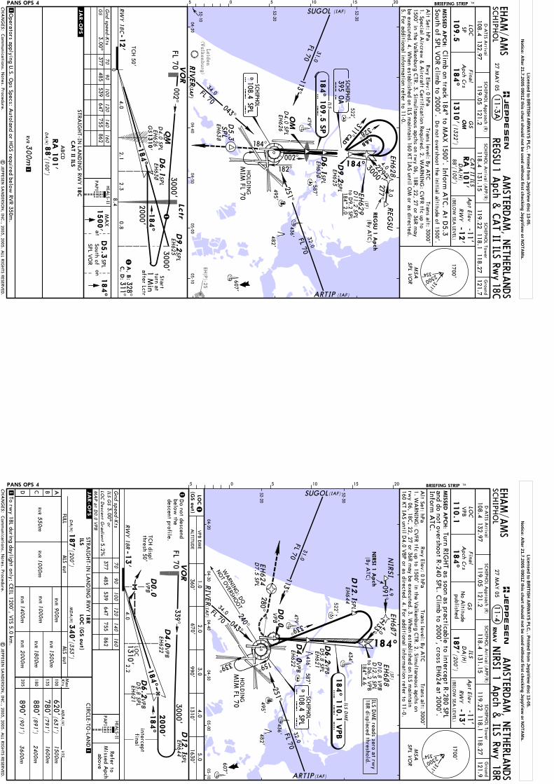
Leiden
(Valkenburg)
EH(P)-25
BRIEFING STRIP TM SCHIPH
OL
AMSTERD
AM, N
ETHERLA
NDS
LOC
184^
1310'
Apt Elev
-11'RW
Y-1
2'
SP
109.5
522'479'
436'
495'
587'
482'
607'
52-10
52-20
52-30
04-2004-40
04-5005-00
05-10
EHAM/A
MS
Final
Apch C
rs
05 5 10 15 20
MSA
SPL V
OR
OM
11-3AREG
SU1Apch
&CATII
ILSRw
y18C
CA
T II ILS
DA
(H)
88'(100')
RA
101'
Gnd speed-K
ts
PAPI
70
90
100
120
140
160
STRAIG
HT-IN
LAN
DIN
G RW
Y
DA
(H)8
8'(1
00')
CA
T II ILS
RVR3
00m
ABCD
1
1
18C
RA
101'
1500'
184^
aton
MA
XD5.3
South ofSPL V
OR SPL
Trans level: By A
TCTrans alt: 3000'
Do not overshoot the initial altitude of 1500'.
Clim
b on track 184^ to MA
X 1500'. Inform
ATC
. At D
5.3
Rwy Elev: 0 hPa
Alt Set: hPa
South of SPL VO
R climb to 2000'.
MIS
SED A
PCH:
(1322')
SCHIPH
OL A
pproach (R)G
round
121.7SC
HIPH
OL Tow
erSC
HIPH
OL A
rrival (APP/R)
D-A
TIS Arrival
119.22 118.1 118.27119.05 121.2
108.4 132.97118.4 131.15
27 MA
Y 05
1. Special Aircrew
& A
ircraft Certification Required. 2. W
ARN
ING
: CVFR tfc up to
1500' in the Valkenburg C
TR. 3. Simultaneous apchs on rw
y 06, 18R, 22, 27 or 36R may
be executed. 4. When established on ILS m
aintain 160 KT IA
S until OM
or as directed.5. For additional inform
ation refer to 11-0.
PANS OPS 4
| JEPPESEN
SAN
DERSO
N, IN
C., 2003, 2005. A
LL RIGHTS RESERV
ED.
SCHIPH
OL
108.4 SPLDS P
L
SCHIPH
OL
395 OA
OA
REG
SU
(By A
TC)
REG
SU 1
Apch
EH628
D5.3
SPL
EH63
8
EH629
(IF)
184^ 2.0
D11.2
SPL
D4.0
SPL
EH62
6
Operators applying U
.S. Ops Specs: A
utoland or HG
S required below RV
R 350m.
EH62
5D9.2
SPL
D9.2
EH62
5 SPL
Com
munications. N
otes. Procedure.
HIA
LS-II
GSD
4.0
SPL
EH62
6G
S1310'
D6.1
SPL
EH63
~
D6.1
SPL
EH63
~
3000'
to D9.2 SPL
RIV
ER(IA
F)
FL 70
184^
-12'
0
M
RW
Y 1
8C
OM
4.08.4 Lc
tr
2000'
002^3000'
VO
R
CHA
NG
ES:
(BELO
W SEA
LEVEL)
311^
2300'
354^
1700'
1328^311^
A, B
:C, D
:
3000'Start
turn at1 M
in184^
1
after Lctr
0.8
JEPPESEN
TCH 50'
377485
539647
755862
3.00^G
S
.JAR-OPS.
OM
182^
184^
ARTIP (IAF)
SUGOL (IAF)
RIV
ER(IA
F)
002^
HO
LDIN
GM
IM FL 70
229^4.0
3.0
277^184^
ILS
184^ 1
09.5
SP
S P113^
FL 70
31.0
251^
32.0
FL 70
043^
34.0FL 70
A&B
328^
311C&D
2.12.3
Licensed to BR
ITISH A
IRW
AYS PLC
, . Printed from JeppView
disc 13-05.N
otice: After 21.7.2005 0901Z this chart should not be used w
ithout first checking JeppView or N
OTA
Ms.
MSA
SPL V
OR
No A
ltitudepublished
Refer toM
issed Apch
above
Do not descend
below the
descent profile.
WARN
ING
: DO
NOT O
VERSHOOT
interceptfinal
280^
BRIEFING STRIP TM SCHIPH
OL
AMSTERD
AM, N
ETHERLA
NDS
LOC
184^
DA
(H)
187'(200')
Apt Elev
-11'RW
Y-1
3'
ALS out
Gnd speed-K
ts
11-4
PAPI
1
1
110.1
ILS
ALS out
FULL
70
90
100
120
140
160
EHAM/A
MS
MIS
SED A
PCH:
NIRSI 1 A
pch & ILS Rw
y 18R
(By A
TC)
NIR
SI 1
Apch
VPB
GS
Turn RIGHT as soon as practicable to intercept R-280 SPL
RNA
V
Alt Set: hPa
Rwy Elev: 0 hPa
Trans level: By A
TCTrans alt: 3000'
and do not overshoot R-240 SPL. Clim
b to 2000', cross EH624 at 2000'.
Inform A
TC.
VO
R
RWY 18R
1
1
184^
D12.1
SPL
VPB
D6.2
EH621
VPB
D4.0
EH622
D0.0
VPB
-13'
240^
339^159^
D4.0
VPB
EH622
D6.2
VPB
EH621
D12.1
SPL
NIR
SIEH
6~7
(IF)
184^ 4.6
EH6~8
D10.8 V
PB
EH624
D0.0
VPB
52-20
52-30
04-2004-30
04-4004-50
05-0005-10
479'
436'
495'
587'
482'
607'
416'
522'
434' to D6.2 V
PB
ILS DM
E
V P
B184^ 1
10.1
VPB
Final
Apch C
rs
05 5 10 15 20
SCHIPH
OL
108.4 SPLDS P
L
SCHIPH
OL A
pproach (R)G
round
121.9SC
HIPH
OL Tow
erSC
HIPH
OL A
rrival (APP/R)
D-A
TIS Arrival
119.22 118.1 118.27119.05 121.2
108.4 132.97118.4 131.15
27 MA
Y 05
D7.5 SP
L
D5.8 SP
L
D12.5 SP
L
EH644
EH644
D5.8 SP
L
PANS OPS 4
| JEPPESEN
SAN
DERSO
N, IN
C., 2003, 2005. A
LL RIGHTS RESERV
ED.
Com
munications. N
otes. Procedure.
HIA
LS-II
LOC
1. WA
RNIN
G: C
VFR tfc up to 1500' in the V
alkenburg CTR. 2. Sim
ultaneous apchs on rw
y 06, 18C, 22, 27 or 36R m
ay be executed. 3. When established on ILS m
aintain 160 K
T IAS until D
4.0 VBP or as directed. 4. For additional inform
ation refer to 11-0.
ILS DM
E reads zero at rwy
18R displaced threshold.
TCH displ
thresh 50'
ARTIP(IAF)
SUGOL(IAF)
RIV
ER(IA
F)
ILSLO
C (G
S o
ut)
(200')D
A(H
)187'
377485
539647
755862
ILS GS
3.00^or
LOC D
escent Gra
dient5.2%
CHA
NG
ES:
(BELO
W SEA
LEVEL)
311^
2300'
354^
1700'
ABCD
Max
Kts
MD
A(H
)
CIRC
LE-TO-LA
ND
STRAIG
HT-IN
LAN
DIN
G RW
Y
100
135
180
205
MD
A(H
)
2400m
3600m
(631')
(891')
(901')
620'
880'
890'
18R
1500m
340' (3
53')
To rwy 18L during daylight only: C
EIL 1200', VIS 5.0 km
.
(791')780'
1600m
VIS
RVR1000m
RVR
1400mRV
RRV
R2000m
RVR1500m
900m
RVR1800m
1000mRV
RRV
R550m
MA
P a
t D0.0 V
PB
FL 703000'
2000'
339^
5.02.0
4.01.0
LOC
(GS o
ut)
3.0990'
360'670'
1310'1630'
2.2
ALTITU
DE
4.01310'
VPB
DM
E
HO
LDIN
GM
IM FL 70
339^
4.9091^
133^ 4.0
184^
184^
JEPPESEN
.JAR-OPS.
113^
FL 70
31.032.0
FL 70
251^
34.0FL 70 043^
Licensed to BR
ITISH A
IRW
AYS PLC
, . Printed from JeppView
disc 13-05.N
otice: After 21.7.2005 0901Z this chart should not be used w
ithout first checking JeppView or N
OTA
Ms.
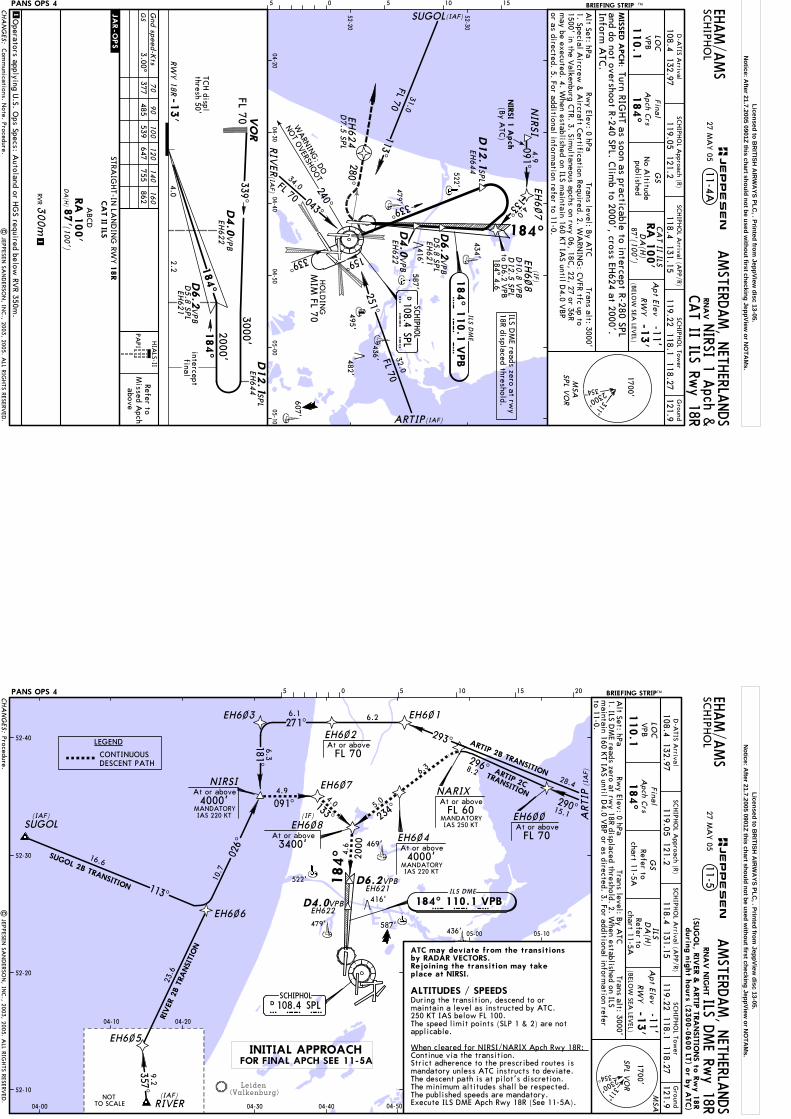
Refer toM
issed Apch
above
interceptfinal
No A
ltitudepublished
MSA
SPL V
OR
PAPI
RNA
V
VO
R
RW
Y 1
8R
184^
D12.1
SPL
VPB
D6.2
EH62
1-1
3'
52-20
52-30
04-2004-30
04-4004-50
05-0005-10
479'
436'
495'
587'
482'
607'
416'
522'
434'
BRIEFING STRIP TM SCHIPH
OL
AMSTERD
AM, N
ETHERLA
NDS
LOC
184^
Apt Elev
-11'RW
Y-1
3'
110.1
GS
EHAM/A
MS
CA
T II ILSRA
100'
DA
(H)
87'(100')
11-4A
Gnd speed-K
ts70
90
100
120
140
160
STRAIG
HT-IN
LAN
DIN
G RW
Y
DA
(H)8
7'(1
00')
CA
T II ILS
RVR3
00m
ABCD
1
1
18R
RA
100'
NIRSI 1 A
pch &CAT II ILS Rw
y 18R
VPB
MIS
SED A
PCH:
Turn RIGHT as soon as practicable to intercept R-280 SPL
Alt Set: hPa
Rwy Elev: 0 hPa
Trans level: By A
TCTrans alt: 3000'
and do not overshoot R-240 SPL. Clim
b to 2000', cross EH624 at 2000'.
Inform A
TC.
05 5 10 15
Final
Apch C
rs
SCHIPH
OL A
pproach (R)G
round
121.9SC
HIPH
OL Tow
erSC
HIPH
OL A
rrival (APP/R)
D-A
TIS Arrival
119.22 118.1 118.27119.05 121.2
108.4 132.97118.4 131.15
27 MA
Y 05
PANS OPS 4
| JEPPESEN
SAN
DERSO
N, IN
C., 2003, 2005. A
LL RIGHTS RESERV
ED.
WARN
ING
: DO
NO
T OVERSHO
OT
280^
(By A
TC)
NIR
SI 1
Apch
240^
339^159^
D6.2
VPB
EH62
1
D12.1
SPL
NIR
SIEH
6~7
(IF)
184^ 4.6
EH6~8
D10.8 V
PB
EH624
to D6.2 V
PB
ILS DM
E
V P
B184^ 1
10.1
VPB
SCHIPH
OL
108.4 SPLDS P
L
D7.5
SPL
D5.8
SPL
D12.5 SP
L
EH64
4
EH64
4
Operators applying U
.S. Ops Specs: A
utoland or HG
S required below RV
R 350m.
Com
munications. N
ote. Procedure.
HIA
LS-II
D5.8
SPL
VPB
D4.0
EH62
2
ILS DM
E reads zero at rwy
18R displaced threshold.
1. Special Aircrew
& A
ircraft Certification Required. 2. W
ARN
ING
: CVFR tfc up to
1500' in the Valkenburg C
TR. 3. Simultaneous apchs on rw
y 06, 18C, 22, 27 or 36R
may be executed. 4. W
hen established on ILS maintain 160 K
T IAS until D
4.0 VBP
or as directed. 5. For additional information refer to 11-0.D
4.0
VPB
EH62
2
TCH displ
thresh 50'
FL 703000'
2000'
339^
184^
CHA
NG
ES:
(BELO
W SEA
LEVEL)
377485
539647
755862
3.00^G
S
311^
2300'
354^
1700'
JEPPESEN
.JAR-OPS.
ARTIP(IAF)
SUGOL(IAF)
RIV
ER(IA
F)
HO
LDIN
GM
IM FL 70
339^
4.9091^
133^ 4.0
184^
113^
FL 70
31.032.0
FL 70
251^
34.0FL 70 043^
2.24.0
Licensed to BR
ITISH A
IRW
AYS PLC
, . Printed from JeppView
disc 13-05.N
otice: After 21.7.2005 0901Z this chart should not be used w
ithout first checking JeppView or N
OTA
Ms.
Leiden(Valkenburg)
ARTIP 2CTRANSITION
NOTTO SCALE
MANDATORYIAS 220 KT MANDATORY
IAS 250 KT
MANDATORYIAS 220 KT
11-5SC
HIPH
OL
LOC
184^
Refer tochart 11-5A
DA
(H)
chart 11-5ARefer to
AMSTERD
AM, N
ETHERLA
NDS
VPB
110.1
ILS
-13'
RW
Y
Apt Elev
-11'
Alt Set: hPa
Rwy Elev: 0 hPa
Trans level: By A
TCTrans alt: 3000'
ILS DME Rw
y 18REH
AM/A
MS
SCHIPH
OL A
pproach (R)G
round
121.9SC
HIPH
OL Tow
erSC
HIPH
OL A
rrival (APP/R)
SUGOL
RIVER
EH6~~EH6~8
EH6~7
EH6~1
EH6~2
EH6~3
EH6~6
EH6~5
NIRSI
357^
026^
113^
181^
091^
271^293^
290^
296^
234^
133^
9.2
16.6
10.7
23.6
4.94.0
4.6
28.4
15.1
8.26.3
5.0
6.26.1
6.3
4000'At or above
3400'At or above
At or aboveFL 70
At or aboveFL 70
52-10
52-20
52-30
52-40
04-00
04-10 04-20
04-30 04-40 04-50
05-00 05-10
ARTIP 2B TRANSITION
EH6~4
4000'At or above
NARIX
FL 60At or above
2000
SUGOL 2B TRANSITION
RIV
ER 2
B T
RANSI
TION
479'436'
587'
416'
522'
MSA
SPL V
OR
D6.2
GS
ILS DME
V P B184^ 110.1 VPB
Final
Apch C
rs
05 5 10 15 20 BRIEFING STRIPTM
SCHIPHOL108.4 SPLDS P L
ATC may deviate from the transitionsby RADAR VECTORS.Rejoining the transition may takeplace at NIRSI.
During the transition, descend to ormaintain a level as instructed by ATC.250 KT IAS below FL 100.The speed limit points (SLP 1 & 2) are notapplicable. When cleared for NIRSI/NARIX Apch Rwy 18R:Continue via the transition.Strict adherence to the prescribed routes ismandatory unless ATC instructs to deviate.The descent path is at pilot's discretion.The minimum altitudes shall be respected.The published speeds are mandatory.Execute ILS DME Apch Rwy 18R (See 11-5A).
ALTITUDES / SPEEDS
| JEPPESEN
SAN
DERSO
N, IN
C., 2003, 2005. A
LL RIGHTS RESERV
ED.
LEGEND
CONTINUOUSDESCENT PATH
D-A
TIS Arrival
469'
119.22 118.1 118.27119.05 121.2
108.4 132.97118.4 131.15
27 MA
Y 05
Procedure.
EH621VPB
1. ILS DM
E reads zero at rwy 18R displaced threshold. 2. W
hen established on ILS m
aintain 160 KT IA
S until D4.0 V
BP or as directed. 3. For additional inform
ation refer to 11-0.
D4.0VPBEH622
(SUG
OL, R
IVER &
ARTIP
TRA
NSIT
IONS to
Rw
y 1
8R
durin
g n
ight h
ours
(2300-0
600 LT
) or b
y A
TC)
PANS OPS 4CHA
NG
ES:
(BELO
W SEA
LEVEL)
RNA
V N
IGHT
311^
2300'
354^
1700'
(IA
F)A
RTI
P
(IAF)
(IAF)
184^
(IF)
JEPPESEN
INITIAL APPROACHFOR FINAL APCH SEE 11-5A
Licensed to BR
ITISH A
IRW
AYS PLC
, . Printed from JeppView
disc 13-05.N
otice: After 21.7.2005 0901Z this chart should not be used w
ithout first checking JeppView or N
OTA
Ms.
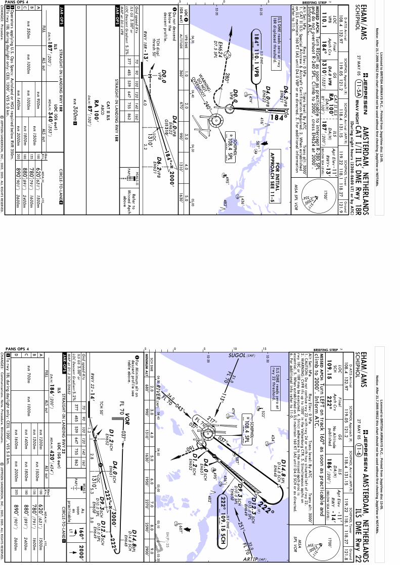
Refer toM
issed Apch
above
Do not descend
below the
descent profile.
WARN
ING
:
DO
NOT
OVERSHO
OT
280^
BRIEFING STRIP TM SCHIPH
OL
AMSTERD
AM, N
ETHERLA
NDS
EHAM/A
MS
SCHIPH
OL A
pproach (R)G
round
121.9SC
HIPH
OL Tow
erSC
HIPH
OL A
rrival (APP/R)
240^
D4.0
VPB
EH622
EH624
D0.0
VPB
1310'
MIS
SED A
PCH:
Turn RIGHT as soon as practicable to intercept R-280 SPL
and do not overshoot R-240 SPL. Clim
b to 2000', cross EH624 at 2000'.
Inform A
TC.
52-20
04-3004-40
04-5005-00
479'
436'
495'
587'
482'
416'
11-5ACAT I/II ILS D
ME Rw
y 18RRNA
V N
IGHT
(1323
')
LOC
VPB
110.1
ILSD
A(H
)
187'(20
0')
87'(100')
DA
(H)
CA
T II ILSA
pt Elev
RW
Y-13'
-11'
184^
GS
D4.0
VPB
RA
100'
2
3.00^5.2%
377485
539647
755862
STRAIG
HT-IN
LAN
DIN
G RW
Y
DA
(H)8
7'(10
0')
CA
T II ILS
RVR3
00m
ABCD
Gnd speed-K
ts70
90
100
120
140
160
1
1To rw
y 18L during daylight only: CEIL 1200', V
IS 5.0 km.
2
PAPI
18R
RA
100'
1
1
RW
Y 1
8R
184^
VPB
D4.0EH
622
D0.0
VPB
-13'
MSA
SPL V
OR
52-25
05 5
ILS DM
E
V P
B184^ 1
10.1
VPB
SCHIPH
OL
108.4 SPLDS P
L
Final
Apch C
rs
.JAR-OPS.
D-A
TIS Arrival
| JEPPESEN
SAN
DERSO
N, IN
C., 2003, 2005. A
LL RIGHTS RESERV
ED.
Operators applying U
.S. Ops Specs: A
utoland or HG
S required below RV
R 350m.
PANS OPS 4
HIA
LS-II
1310'
GS
LOC
119.22 118.1 118.27108.4 132.97
119.05 121.2118.4 131.15
Procedure.
27 MA
Y 05
D6.2
VPB
EH621
D6.2
VPB
EH621
D7.5
SPL
ILS DM
E reads zero at rwy
18R displaced threshold.
Alt Set: hPa
Rwy Elev: 0 hPa
Trans level: By A
TCTrans alt: 3000'
1. CA
T II ILS: Special Aircrew
& A
ircraft Certification Required. 2. W
hen established on ILS m
aintain 160 KT IA
S until D4.0 V
BP or as directed. 3. For additional inform
ation refer to 11-0.
FO
R IN
ITIA
LA
PPRO
ACH S
EE 1
1-5
TCH displ
thresh 50'
CHA
NG
ES:
311^
2300'
354^
1700'
(Durin
g n
ight h
ours
(2300-0
600 LT
) or b
y A
TC)
(BELO
W SEA
LEVEL)
ABCD
FULL
ALS out
ALS out
MD
A(H
)M
axKts
100
135
180
205
STRAIG
HT-IN
LAN
DIN
G RW
YCIRC
LE-TO-LA
ND
620'780'
3600m
2400m
1600m
1500m
ILS
DA
(H)1
87'(20
0')
RVR
LOC (G
S o
ut)
MD
A(H
)340'(3
53')
(631')
(791')
(891')
(901')
VIS
1000m
RVR
1400mRV
RRV
R2000m
RVR1500m
RVR1000m
RVR
550m
LOC D
escent Gra
dient
ILS GS
or
880'890'
900m
RVR1800m
MA
P a
t D0.0 V
PB
18R
5.02.0
4.01.0
LOC
(GS o
ut)
3.0990'
360'670'
1310'1630'
ALTITU
DE
VPB
DM
E
2000'
2.24.0
1310'
JEPPESEN
.JAR-OPS.
184^
Licensed to BR
ITISH A
IRW
AYS PLC
, . Printed from JeppView
disc 13-05.N
otice: After 21.7.2005 0901Z this chart should not be used w
ithout first checking JeppView or N
OTA
Ms.
EH(P)-25
SCHIPH
OL
108.4 SPLDS P
L
522'
479'
436'
495'
587'
482'
607'
434'
(IF)
52-20
52-30
04-3004-40
04-5005-00
05-1005-20
ILS DM
E
S C H
222^ 1
09.1
5 S
CH
For Minim
um alt on
descent profile seetable above.
As
soon as
practicable
222^
TCH 50'
ALS out
Gnd speed-K
tsM
IALS
PAPI
1
1
ALS out
FULL
70
90
100
120
140
160
160^
2000'
LT
| JEPPESEN
SAN
DERSO
N, IN
C., 2003, 2005. A
LL RIGHTS RESERV
ED.
PANS OPS 4
LOC
Com
munications. N
ote. Procedure. Minim
ums.
MSA
SPL V
OR
No A
ltitudepublished
MIS
SED A
PCH:
BRIEFING STRIP TM SCHIPH
OL
AMSTERD
AM, N
ETHERLA
NDS
LOC
222^
DA
(H)
186'(2
00')
Apt Elev
-11'RW
Y-1
4'
11-6
Alt Set: hPa
Rwy Elev: 0 hPa
Trans level: By A
TCTrans alt: 3000'
109.1
5
GS
ILS
ILS DME Rw
y 22
SCH
EHAM/A
MSTurn LEFT on track 160^ as soon as practicable and
climb to 2000'. Inform
ATC
.
Final
Apch C
rs
SCHIPH
OL A
pproach (R)G
round
121.8SC
HIPH
OL Tow
erSC
HIPH
OL A
rrival (APP/R)
D-A
TIS Arrival
119.22 118.1 118.27119.05 121.2
108.4 132.97118.4 131.15
27 MA
Y 05
1. CA
UTIO
N: D
o not confuse rwy 22 w
ith rwy 24 or w
ith twy situated left of rw
y 22.2. W
ARN
ING
: CVFR tfc up to 1500' in the V
alkenburg CTR. 3. Sim
ultaneous apchs on rw
y 18C or 18R m
ay be executed. 4. Strict adherence to the missed apch proc is
essential. 5. When established on ILS m
aintain 160 KT IA
S until D4.0 SC
H or as directed.
6. For additional info refer to 11-0.
ILS DM
E reads zero at rw
y 22 threshold.
05 5 10 15
1
(IAF)
(IAF)
(IAF)
SUGOL
RIV
ER
217^FL 70037^
222^
037^
ARTIP
160^
SCH
D12.3
D9.3
SCH
D14.8
SPL
D14.8 SC
HEH
648
EH649
EH65~
D13.0 SP
L
D10.0 SP
L
EH651
D4.0
SCH
D1.2
SCH
EH652
113^
FL 70
31.0
043^
FL 70
34.0
251^FL 7032.0
FL 70
-14'
222^
1.25.3
D1.2
D9.3
RW
Y 2
2
3000'
VO
R
1
1
3.0
MIN
IMUM
ALT
ILSLO
C (G
S o
ut)
(200')
DA
(H)1
86'
377485
539647
755862
ILS GS
3.00^or
LOC D
escent Gra
dient5.2%
CHA
NG
ES:
ABCD
Max
Kts
MD
A(H
)
CIRC
LE-TO-LA
ND
STRAIG
HT-IN
LAN
DIN
G RW
Y
100
135
180
205
MD
A(H
)
2400m
3600m
(631')
(891')
(901
')
620'
880'
890'
1500m
420' (4
34')
To rwy 18L during daylight only: C
EIL 1200', VIS 5.0 km
.
(791')
780'1600m
VIS
RVR1
400m
RVR
1600m
RVR
RVR
2000m
RVR1500m
RVR1800m
1000m
RVR
RVR
700m
22
1200m
1300m
RVR
SCH
SCH
SCH
SCH D
ME
D10.0 SP
LD12.3
D13.0 SP
L
037^
1310'1630'
680'990'
2.03.0
4.05.0
1950'6.0
7.02270'
8.02590'
9.02900'
.JAR-OPS.
SPL
D14.8
MA
P a
t D1.2
SCH/EH
652
EH649
EH65~
EH651
D4.0
SCH
EH652
2.81310'
(BELO
W SEA
LEVEL)
311^
2300'
354^
1700'
JEPPESEN
D14.8 SC
HEH
648
Licensed to BR
ITISH A
IRW
AYS PLC
, . Printed from JeppView
disc 13-05.N
otice: After 21.7.2005 0901Z this chart should not be used w
ithout first checking JeppView or N
OTA
Ms.

Leiden
(Valkenburg)
EH(R)-10
EH(P)-25
Soesterberg
MSA
SPL V
OR
MIS
SED A
PCH:
BRIEFING STRIP TM SCHIPH
OL
AMSTERD
AM, N
ETHERLA
NDS
LOC
268^
DA
(H)
188'(200')
Apt Elev
-11'RW
Y-1
2'
ALS out
Gnd speed-K
ts2000'
268^
on
Clim
b on track 268^ to 2000'. Inform A
TC.
11-7
PAPI
1
1
111.5
5
ILS
ALS out
FULL
70
90
100
120
140
160
BVB
BVB
52-20
04-3004-40
04-5005-00
05-1005-20
273^
522'
479'
436'
587'
EHAM/A
MS
Expedite climb to 2000'.
Alt Set: hPa
Rwy Elev: 0 hPa
Trans level: By A
TCTrans alt: 3000'
| JEPPESEN
SAN
DERSO
N, IN
C., 2001, 2005. A
LL RIGHTS RESERV
ED.
Final
Apch C
rs
495'482'
683'
416'
GS
No A
ltitudepublished
BVB
HIA
LS-II
ILS DME Rw
y 27
BVB
EH64~
EH63
9
1D
o not descendbelow
the descentprofile.
1
52-10
05 5 10 15
EH64~
EH63
9
LOC
SCHIPH
OL A
pproach (R)G
round
121.8SC
HIPH
OL Tow
erSC
HIPH
OL A
rrival (APP/R)
D-A
TIS Arrival
119.22 118.1 118.27119.05 121.2
108.4 132.97118.4 131.15
27 MA
Y 05
PANS OPS 4
D5.8
SPL
D7.9
SPL
D5.8
SPL
D7.9
SPL
093^
Com
munications. N
ote. Procedure.
SCHIPH
OL
108.4 SPLD
S P L
1. WA
RNIN
G: W
hen average surface wind velocity exceeds 30 K
T, moderate turbulence
can be expected on final approach from approx D
3.0 BVB to D
1.0 BVB. 2. C
VFR tfc up to
1500' in the Valkenburg C
TR. 3. Simultaneous apchs on rw
y 06, 18C, 18R or 36R m
ay be executed. 4. W
hen established on ILS maintain 160 K
T IAS until D
4.0 BVB or as directed.
5. ILS DM
E reads zero at rwy 27 thresh. 6. For additional inform
ation refer to 11-0.
093^
251^113^
268^
043^
D0.0
32.0
31.0
(IAF)
(IAF)ARTIP
SUGOL
FL 70
FL 70
34.0FL 70
ILSLO
C (G
S o
ut)
(200')D
A(H
)188'
377485
539647
755862
ILS GS
3.00^or
LOC D
escent Gra
dient5.2%
CHA
NG
ES:
(BELO
W SEA
LEVEL)
311^
2300'
354^
1700'
ABCD
Max
Kts
MD
A(H
)
CIRC
LE-TO-LA
ND
STRAIG
HT-IN
LAN
DIN
G RW
Y
100
135
180
205
MD
A(H
)
2400m
3600m
(631')
(891')
(901')
620'
880'
890'
1500m
430' (442')
To rwy 18L during daylight only: C
EIL 1200', VIS 5.0 km
.
(791')780'
1600m
VIS
1000mRV
R
1400mRV
RRV
R2000m
RVR1500m
1000mRV
RRV
R550m
MA
P a
t D0.0 B
VB
27
RVR
-12'
1 Min
2000'
1310'
FL70
D0.0
124^141^
3000' Lctr
4.02.2
2.58.7
CA
T A
& B
CA
T C
& D
Startturn at
Lctr268^
268^
RWY 27
TCH
50'
093^D6.2
VO
R
0
(IAF)
RIVER
BVB
HO
LDIN
GM
IM FL 70
after
JEPPESEN
.JAR-OPS.
141^
124^C&D
SCHIPH
OL
376 WP
W P
268^
A&B
900m
RVR
1800m
268^ 1
11.5
5 B
VB
B V
B
D4.0
(GS o
ut)
LOC
1.0360'
2.0680'
3.04.0
1310'5.0
1630'BVB D
ME
ALTITU
DE
D4.0
BVB
BVB
D6.2
ILS DM
E
1000'
Licensed to BR
ITISH A
IRW
AYS PLC
, . Printed from JeppView
disc 13-05.N
otice: After 21.7.2005 0901Z this chart should not be used w
ithout first checking JeppView or N
OTA
Ms.
Leiden
(Valkenburg)
EH(R)-10
Soesterberg
EH(P)-25
MSA
SPL V
OR
MIS
SED A
PCH:
BRIEFING STRIP TM SCHIPH
OL
AMSTERD
AM, N
ETHERLA
NDS
LOC
268^
Apt Elev
-11'RW
Y-1
2'
2000'
268^
on
Clim
b on track 268^ to 2000'. Inform A
TC.
PAPI
Trans alt: 3000'
111.5
5
52-10
52-20
04-3004-40
04-5005-00
05-1005-20
522'
479'
436'
495'
587'
482'
683'
502'
11-7A
CA
T II ILSRA
101'
DA
(H)
(100')88'
STRAIG
HT-IN
LAN
DIN
G RW
Y
DA
(H)8
8'(100')
CA
T II ILS
RVR3
00m
ABCD
1
1
RA
101'
27
Gnd speed-K
ts70
90
100
120
140
160
EHAM/A
MS
Expedite climb to 2000'.
Rwy Elev: 0 hPa
Trans level: By A
TCA
lt Set: hPa
Final
Apch C
rs
05 5 10 15 20
416'
GS
No A
ltitudepublished
BVB
| JEPPESEN
SAN
DERSO
N, IN
C., 2001, 2005. A
LL RIGHTS RESERV
ED.
HIA
LS-II
Operators applying U
.S. Ops Specs: A
utoland or HG
S required below RV
R 350m.
EH63
9 BVB
CAT II ILS D
ME Rw
y 27
BVB
EH64~
SCHIPH
OL A
pproach (R)G
round
121.8SC
HIPH
OL Tow
erSC
HIPH
OL A
rrival (APP/R)
D-A
TIS Arrival
119.22 118.1 118.27119.05 121.2
108.4 132.97118.4 131.15
27 MA
Y 05
PANS OPS 4
273^EH
64~EH
639
D5.8
SPL
D7.9
SPL
093^
D5.8
SPL
D7.9
SPL
Com
munications. N
ote. Procedure.
SCHIPH
OL
108.4 SPLDS P
L
1. WA
RNIN
G: W
hen average surface wind velocity exceeds 30 K
T, moderate turbulence
can be expected on final approach from approx D
3.0 BVB to D
1.0 BVB. 2. C
VFR tfc up to
1500' in the Valkenburg C
TR. 3. Simultaneous apchs on rw
y 06, 18C, 18R or 36R m
ay be executed. 4. W
hen established on ILS maintain 160 K
T IAS until D
4.0 BVB or as directed.
5. ILS DM
E reads zero at rwy 27 thresh. 6. For additional inform
ation refer to 11-0.
CHA
NG
ES:
(BELO
W SEA
LEVEL)
311^
2300'
354^
1700'
-12'
1 Min
2000'
FL70124^141^
3000' Lctr
4.08.7
CA
T A
& B
CA
T C
& D
Startturn at
Lctr268^
268^
RWY 27
093^V
OR
0
377485
539647
755862
3.00^G
S
TCH 50'
after
JEPPESEN
.JAR-OPS.
D6.2
D4.0
2.22.5
093^
251^113^
268^
043^
32.0
31.0
(IAF)
(IAF)ARTIP
SUGOL
FL 70
FL 7034.0FL 70
(IAF)RIVER
HO
LDIN
GM
IM FL 70
141^
124^C&D
SCHIPH
OL
376 WP
W P
268^
A&B
268^ 1
11.5
5 B
VB
B V
B
D4.0
BVB
BVB
D6.2
ILS DM
E
Licensed to BR
ITISH A
IRW
AYS PLC
, . Printed from JeppView
disc 13-05.N
otice: After 21.7.2005 0901Z this chart should not be used w
ithout first checking JeppView or N
OTA
Ms.

Leiden
(Valkenburg)
EH(P)-26
EH(P)-25
EH(P)-27
No A
ltitudepublished
interceptfinal
Do not descend
below the
descent profile.
D13.3
D13.3
004^
207^
D0.0
D0.0
VO
R
D4.0
RW
Y 3
6C-1
2'
207^
1
1
004^
(IF)
SPL
SA
SPL
SA
MIS
SED A
PCH:
BRIEFING STRIP TM SCHIPH
OL
AMSTERD
AM, N
ETHERLA
NDS
LOC
004^
DA
(H)
188'(2
00')
Apt Elev
-11'RW
Y-1
2'
MSA
SPL V
OR
ALS out
Gnd speed-K
ts2000'
004^
on
Clim
b on track 004^ to 2000'. Inform A
TC.
11-8
PAPI
1
1
SA
Alt Set: hPa
Rwy Elev: 0 hPa
Trans level: By A
TCTrans alt: 3000'
108.7
5
GS
ILS
ALS out
FULL
70
90
100
120
140
160
EHAM/A
MS
LOMKO1Apch
&ILS
DMERw
y36C
SA
EH63
3
EH63
2
D6.2
SA
SCHIPH
OL
108.4 SPLDS P
L
52-10
52-20
04-3004-40
04-5005-00
05-10
LOM
KO
EH62
~ EH619
LOM
KO
1 A
pch
(By A
TC)
D13
.2 SA
D4.0
SA
EH63
3
D6.2
SA
EH63
2
479'
436'
495'
587'
482'
446'
683'
502'
416'
Final
Apch C
rs
05 5 10 15 20
S AILS D
ME
004^ 1
08.7
5 S
A
HIA
LS-II
SCHIPH
OL A
pproach (R)G
round
121.7SC
HIPH
OL Tow
erSC
HIPH
OL A
rrival (APP/R)
D-A
TIS Arrival
119.22 118.1 118.27119.05 121.2
108.4 132.97118.4 131.15
27 MA
Y 05
D5.6
SPL
D7.8
SPL
D14.8 SP
L
EH657
EH657
D7.8
SPL
D5.6
SPL
PANS OPS 4
| JEPPESEN
SAN
DERSO
N, IN
C., 2003, 2005. A
LL RIGHTS RESERV
ED.
Com
munications. Procedure.
ILS DM
E reads zero at rw
y 36C displaced
threshold.
LOC
1. WA
RNIN
G: C
VFR tfc up to 1500' in the V
alkenburg CTR. 2. Sim
ultaneous apchs rwy
36R may be executed. 3. W
hen established on ILS maintain 160 K
T IAS until
D4.0 SA
or as directed. 4. For additional information refer to 11-0.
TCH displ
thresh 50'
(IAF)
(IAF)
(IAF)
SUGOL
RIV
ER
FL 70004^
FL 703000'
2000'
207^
ARTIP
5.02.0
4.01.0
LOC
(GS o
ut)
3.0360'
680'1310'
1630'
2.2
ILSLO
C (G
S o
ut)
(200')
DA
(H)1
88'
377485
539647
755862
ILS GS
3.00^or
LOC D
escent Gra
dient5.2%
ALTITU
DE
4.0
SA D
ME
MA
P a
t D0.0 SA
CHA
NG
ES:
(BELO
W SEA
LEVEL)
311^
2300'
354^
1700'
ABCD
Max
Kts
MD
A(H
)
CIRC
LE-TO-LA
ND
STRAIG
HT-IN
LAN
DIN
G RW
Y
100
135
180
205
MD
A(H
)
2400m
3600m
(631')
(891')
(901
')
620'
880'
890'
36C
1500m
340' (3
52')
To rwy 18L during daylight only: C
EIL 1200', VIS 5.0 km
.
(791')
780'1600m
VIS
RVR1
000mRV
R1400m
RVR
RVR
2000m
RVR1500m
900m
RVR1800m
1000m
RVR
RVR
550m
094^
3.02.0049^ 7.0
1310'
004^
JEPPESEN
.JAR-OPS.
1000'
113^
FL 70
31.0
251^FL 7032.0
043^
FL 70
34.0
Licensed to BR
ITISH A
IRW
AYS PLC
, . Printed from JeppView
disc 13-05.N
otice: After 21.7.2005 0901Z this chart should not be used w
ithout first checking JeppView or N
OTA
Ms.
Leiden
(Valkenburg)
EH(P)-26
EH(P)-25
EH(P)-27
No A
ltitudepublished
interceptfinal
D13.3
VO
RRW
Y 3
6C-1
2'
004^
SPL
MIS
SED A
PCH:
BRIEFING STRIP TM SCHIPH
OL
AMSTERD
AM, N
ETHERLA
NDS
LOC
004^
Apt Elev
-11'RW
Y-1
2'
MSA
SPL V
OR
Clim
b on track 004^ to 2000'. Inform A
TC.
SA
108.7
5
GS
EHAM/A
MS
52-10
52-20
04-3004-40
04-5005-00
05-10
479'
436'
495'
587'
482'
446'
607'
502'
416' CA
T II ILSRA
100'
DA
(H)
88'(100')
11-8A
Gnd speed-K
ts2000'
004^
onPA
PI
70
90
100
120
140
160
STRAIG
HT-IN
LAN
DIN
G RW
Y
DA
(H)8
8'(1
00')
CA
T II ILS
RVR3
00m
ABCD
1
1
36C
RA
100'
LOMKO 1 A
pch &CAT II ILS D
ME Rw
y 36C
D6.2
SA
EH63
2
Final
Apch C
rs
05 5 10 15 20
HIA
LS-II
SCHIPH
OL A
pproach (R)G
round
121.7SC
HIPH
OL Tow
erSC
HIPH
OL A
rrival (APP/R)
D-A
TIS Arrival
119.22 118.1 118.27119.05 121.2
108.4 132.97118.4 131.15
27 MA
Y 05
Operators applying U
.S. Ops Specs: A
utoland or HG
S required below RV
R 350m.
| JEPPESEN
SAN
DERSO
N, IN
C., 2003, 2005. A
LL RIGHTS RESERV
ED.
PANS OPS 4
D13.3
004^
207^
207^
(IF)
SPL
EH63
2
D6.2
SA
SCHIPH
OL
108.4 SPLDS P
L
LOM
KO
EH62~ EH
619
LOM
KO
1 A
pch
(By A
TC)
D13
.2 SA
S AILS D
ME
004^ 1
08.7
5 S
A
D7.8
SPL
D14.8 SP
L
EH657
EH657
D7.8
SPL
Com
munications. Procedure.
D4.0
EH63
3D
5.6
SPL
D4.0
SA
EH63
3D
5.6
SPL
SA
ILS DM
E reads zero at rw
y 36C displaced
threshold.
Alt Set: hPa
Rwy Elev: 0 hPa
Trans level: By A
TCTrans alt: 3000'
1. Special Aircrew
& A
ircraft Certification Required. 2. W
ARN
ING
: CVFR tfc up to
1500' in the Valkenburg C
TR. 3. Simultaneoous apchs on rw
y 36R may be executed .
When established on ILS m
aintain 160 KT IA
S until D4.0 SA
or as directed. 4. For additional info refer to 11-0.
TCH displ
thresh 50'
FL 703000'
2000'
CHA
NG
ES:
(BELO
W SEA
LEVEL)
311^
2300'
354^
1700'
377485
539647
755862
3.00^G
S
207^
004^
JEPPESEN
.JAR-OPS.
(IAF)
(IAF)
(IAF)
SUGOL
RIV
ER
FL 70004^
ARTIP
094^
3.02.0049^ 7.0
113^
FL 70
31.0
251^FL 7032.0
043^
FL 70
34.0
4.02.2
Licensed to BR
ITISH A
IRW
AYS PLC
, . Printed from JeppView
disc 13-05.N
otice: After 21.7.2005 0901Z this chart should not be used w
ithout first checking JeppView or N
OTA
Ms.

Leiden
(Valkenburg)
D2.8
SPL
No A
ltitudepublished
D0.0
D6.2
ABA
BRIEFING STRIP TM SCHIPH
OL
AMSTERD
AM, N
ETHERLA
NDS
LOC
004^
DA
(H)
189'(200')
Apt Elev
-11'RW
Y-1
1'
MSA
SPL V
OR
ALS out
Gnd speed-K
ts
1500'
004^
at
11-9
PAPI
1
1
111.9
5
ILS
ALS out
FULL
70
90
100
120
140
160
SCHIPH
OL
N V332 N
V
436'
495'482'
52-10
52-20
ABA
EHAM/A
MS
MIS
SED A
PCH:
Do not overshoot the initial altitude of 1500'.
Alt Set: hPa
Rwy Elev: 0 hPa
Trans level: By A
TCTrans alt: 3000'
on
MA
XD2.8
North of
SPL VO
R SPL
Clim
b on track 004^ to MA
X 1500'. Inform
ATC
. At D
2.8N
orth of SPL VO
R climb to 2000'.
MONUT 1 A
pch & ILS Rw
y 36R
EH63
7
MO
NUT 1
Apch
(By A
TC)
MO
NUT
04-4004-50
05-00EH634
EH61
5
EH634
(IF)
EH61
7
NO
T TO SC
ALE
GS
SCHIPH
OL
108.4 SPLD
S P L
to Lctr178^ 10.9
3000
Final
Apch C
rs
05 5 10
HIA
LS-II
ABA
FL70
D9.3
ABA
D11.3
ABA
D9.3
ABA
ALTITU
DE
8.02590'
7.02270'
ABA
DM
E
5.01630'
4.01310'
3.01000'
2.01.0
680'360'
2
D8.4
ABA
LOC
(GS o
ut)
D0.0
ABA
EH634
D9.3
ABA
D8.4
ABA
| JEPPESEN
SAN
DERSO
N, IN
C., 2003, 2005. A
LL RIGHTS RESERV
ED.
PANS OPS 4
ABA
D3.8
SCHIPH
OL A
pproach (R)G
round
121.8SC
HIPH
OL Tow
erSC
HIPH
OL A
rrival (APP/R)
D-A
TIS Arrival
119.22 118.1 118.27119.05 121.2
108.4 132.97118.4 131.15
27 MA
Y 05
EH63
5
EH63
6
D6.4
SPL
D8.7
SPL
D11.8 SP
L
D13.8 SP
L
D6.2
ABA
EH63
6D
8.7
SPL
ABA
D3.8
EH63
5D
6.4
SPL
D11.8 SP
L
178^
358^
Com
munications. Procedure.
1. WA
RNIN
G: C
VFR tfc up to 1500' in the V
alkenburg CTR. 2. Sim
ultaneous apchs on rwy
06, 18C, 18R, 27 or 36C
may be executed. 3. For additional inform
ation refer to 11-0.
D11.8 SP
L
ILS DM
E reads zero at rw
y 36R threshold.W
hen established on ILSm
aintain 160 KT IA
S untilD
3.8 ABA
or as directed.
LOC
004^
004^131^
148^
SUG
OL
ARTIP
(IAF)
(IAF)
RIV
ER(IA
F)
C&D
A&B
ILSLO
C (G
S o
ut)
(200')D
A(H
)189'
377485
539647
755862
ILS GS
3.00^or
LOC D
escent Gra
dient5.2%
CHA
NG
ES:
(BELO
W SEA
LEVEL)
311^
2300'
354^
1700'
ABCD
Max
Kts
MD
A(H
)
CIRC
LE-TO-LA
ND
100
135
180
205
MD
A(H
)
2400m
3600m
(631')
(891')
(901')
620'
880'
890'
1500m
430' (441')
To rwy 18L during daylight only: C
EIL 1200', VIS 5.0 km
.
(791')780'
1600m
VIS
RVR1000m
RVR
1400mRV
RRV
R2000m
RVR1500m
900m
RVR1800m
1000mRV
RRV
R550m
MA
P a
t D0.0 A
BA
3.0274^
2.0319^
2.0
004^JEPPESEN
.JAR-OPS.
36R
STRAIG
HT-IN
LAN
DIN
G RW
Y
ILS DM
E
004^ 1
11.9
5 A
BA
A B A
TCH
50'
-11'
RW
Y 3
6R0.9
1 Min
turn atStart
3.8
Lctr
1260'2.4
004^
3000'
1148^131^
3000'
after Lctr004^
2.2
2000'
A, B
:C, D
:
1
2D
o not descend belowdescent profile.
113^
31.0FL 70
251^
FL 7032.0
043^
34.0FL 70
Licensed to BR
ITISH A
IRW
AYS PLC
, . Printed from JeppView
disc 13-05.N
otice: After 21.7.2005 0901Z this chart should not be used w
ithout first checking JeppView or N
OTA
Ms.
Leiden
(Valkenburg)
No A
ltitudepublished
BRIEFING STRIP TM SCHIPH
OL
AMSTERD
AM, N
ETHERLA
NDS
LOC
004^
Apt Elev
-11'RW
Y-1
1'
MSA
SPL V
OR
111.9
5
436'
495'482'
52-10
52-20
EHAM/A
MS
MIS
SED A
PCH:
Do not overshoot the initial altitude of 1500'.
Alt Set: hPa
Rwy Elev: 0 hPa
Trans level: By A
TCTrans alt: 3000'
Clim
b on track 004^ to MA
X 1500'. Inform
ATC
. At D
2.8N
orth of SPL VO
R climb to 2000'.
EH63
5
EH634
04-4004-50
05-00
MONUT1Apch
&ILS
Rwy36R
IICAT
GS
CA
T II ILSRA
102'
DA
(H)
(100')89'
11-9A
STRAIG
HT-IN
LAN
DIN
G RW
Y
DA
(H)8
9'(100')
CA
T II ILS
RVR3
00m
ABCD
1
36R
RA
102'
Gnd speed-K
ts70
90
100
120
140
160
1500'
004^
atPA
PIon
MA
XD2.8
North of
SPL VO
R SPL
1
Final
Apch C
rs
05 5 10
HIA
LS-II
D9.3
ABA
ABA
D8.4
ABA
| JEPPESEN
SAN
DERSO
N, IN
C., 2003, 2005. A
LL RIGHTS RESERV
ED.
D3.8
ABA
PANS OPS 4
Operators applying U
.S. Ops Specs: A
utoland or HG
S required below RV
R 350m.
SCHIPH
OL A
pproach (R)G
round
121.8SC
HIPH
OL Tow
erSC
HIPH
OL A
rrival (APP/R)
D-A
TIS Arrival
119.22 118.1 118.27119.05 121.2
108.4 132.97118.4 131.15
27 MA
Y 05
D2.8
SPL
SCHIPH
OL
N V332 N
V
EH63
7
MO
NUT 1
Apch
(By A
TC)
MO
NUT
EH634
EH61
5
EH634
(IF)
EH61
7
NO
T TO SC
ALE
SCHIPH
OL
108.4 SPLDS P
Lto Lctr
178^ 10.93000
FL70
D9.3
ABA
D11.3
ABA
D9.3
ABA
D8.4
ABA
ABA
D3.8
EH63
5D
6.4 SP
L
D11.8 SP
LD
11.8 SPL
178^
358^
D11.8 SP
L
D6.4
SPL
Com
munications. Procedure.
1. Special Aircrew
& A
ircraft Certification Required. 2. W
ARN
ING
: CVFR tfc up to
1500' in the Valkenburg C
TR. 3. Simultaneous apchs on rw
y 06, 18C, 18R, 27 or 36C
m
ay be executed. 4. For additional information refer to 11-0.
D6.2
ABA
EH63
6D
8.7 SP
L
D6.2
ABA
EH63
6D
8.7 SP
L
ILS DM
E reads zero at rw
y 36R threshold.W
hen established on ILSm
aintain 160 KT IA
S untilD
3.8 ABA
or as directed.
CHA
NG
ES:
(BELO
W SEA
LEVEL)
311^
2300'
354^
1700'
-11'
RW
Y 3
6R0.9
1 Min
turn atStart
3.8
Lctr
004^
3000'
1148^131^ 3000'
after Lctr004^
2000'A
, B:
C, D
:
1
TCH 50'
377485
539647
755862
3.00^G
S
JEPPESEN
.JAR-OPS.
004^
004^131^
SUG
OL
ARTIP
(IAF)
(IAF)
RIV
ER(IA
F)
C&D
3.0274^
2.0319^
2.0
004^
ILS DM
E
004^ 1
11.9
5 A
BA
A B A
113^
31.0FL 70
251^
FL 7032.0
043^
34.0FL 70
A&B148^
2.22.4
Licensed to BR
ITISH A
IRW
AYS PLC
, . Printed from JeppView
disc 13-05.N
otice: After 21.7.2005 0901Z this chart should not be used w
ithout first checking JeppView or N
OTA
Ms.

Leiden
(Valkenburg)
EH(P)-25
[MD
~9]
[MD
~9]
[3.00^]
[3.00^]
[TCH displ
thresh 50']
Apt Elev
-11'RW
Y-1
2'
086^
278^
086^
FL 70(IF)
MIS
SED A
PCH:
BRIEFING STRIP TM SCHIPH
OL
13-1AMSTERD
AM, N
ETHERLA
NDS
VO
RPA
M
117.8
086^
Minim
um A
ltD18.9
PA
M
2000'
MD
A(H
)
570'(582
')
2000'
PAM
117.8
MSA
SPL V
OR
278^
VOR D
ME Rw
y 09
1
1
onR-2
66
Alt Set: hPa
Rwy Elev: 0 hPa
Trans level: By A
TCTrans alt: 3000'
Clim
b inbound on R-266 PAM
to 2000'. Inform A
TC.
52-10
52-20
52-3004-2004-40
04-5005-00
05-10
522'
479'
436'
495'
587'
482'
607'
434'
(R-266 PAM
)
EHAM/A
MS
Gnd speed-K
ts70
90
100
120
140
160
372478
531637
743849
Descent a
ngle
416'SC
HIPH
OL
108.4 SPLDS P
L
4.7
Final
Apch C
rs
05 5 10 15 20
(2012')
SCHIPH
OL A
pproach (R)G
round
121.8SC
HIPH
OL Tow
erSC
HIPH
OL A
rrival (APP/R)
D-A
TIS Arrival
119.22 118.1 118.27119.05 121.2
108.4 132.97118.4 131.15
27 MA
Y 05
PANS OPS 4
| JEPPESEN
SAN
DERSO
N, IN
C., 2003, 2005. A
LL RIGHTS RESERV
ED.
1. WA
RNIN
G: C
VFR tfc up to 1500' in the V
alkenburg CTR. 2. Sim
ultaneous approaches on rw
y 06 may be executed. 3. For additional inform
ation refer to 11-0.
098^
Com
munications. N
ote. Procedure.
Do not descend
below descent
profile.
DPA
MPU
SPA
M
117.8
PA
MP
A MD18.9
D14.2
PA
M
D24.1
PA
M
(IAF)SUGOL
ARTIP (IAF)
D21.9
PA
M
CHA
NG
ES:
(BELO
W SEA
LEVEL)
ABCD
Max
Kts
CIRC
LE-TO-LA
ND
STRAIG
HT-IN
LAN
DIN
G RW
Y
100
135
180
205
MD
A(H
)570' (582
')
09
311^
2300'
354^
1700'
-12'
1
FL 703000'2
000'
086^
1.5RW
Y 09
SPL V
OR
PA
M
PA
M
D18.9
D14.2
D24.1
PA
MD
11.6 SP
LPA
MVO
R
3.0D21.9
PA
M
18.0PA
M D
ME
17.016.0
1720'1400'
1080'15.0760'
ALTITU
DE RIV
ER(IA
F)
To rwy 18L during daylight only: C
EIL 1200', VIS 5.0 km
.
1
MD
A(H
)
2400m
3600m
(631')
(891')
(901')
620'
880'
890'
1500m
(791')780'
1600m
VIS
RVR
2000m
RVR1500m
Descent G
radient
or
5.24%
MA
P a
t D14.2 P
AM
JEPPESEN
.JAR-OPS.
500'14.2
D11.6 SP
L/EH64
1
EH642
EH643EH
643
EH642
EH641
113^
FL 70
31.0
043^
34.0FL 70
251^FL 7032.0
Licensed to BR
ITISH A
IRW
AYS PLC
, . Printed from JeppView
disc 13-05.N
otice: After 21.7.2005 0901Z this chart should not be used w
ithout first checking JeppView or N
OTA
Ms.
[3.00^]
[3.00^][TC
H displ
thresh 50']
MSA
SPL V
OR
Refer toM
issed Apch
above
Do not descend
below the
descent profile.
WARN
ING: D
O
NO
T OVERSHO
OT
1. WA
RNIN
G: C
VFR tfc up to 1500' in the V
alkenburg CTR.
2. For additional information refer to 11-0.
SPLVOR
280^
BRIEFING STRIP TM SCHIPH
OL
AMSTERD
AM, N
ETHERLA
NDS
VO
R
185^
Apt Elev
-11'RW
Y-1
3'
13-2
PAPI
1
113.9
5
EHAM/A
MS
MIS
SED A
PCH:
AM
S
Alt Set: hPa
Rwy Elev: 0 hPa
Trans level: By A
TCTrans alt: 3000'
RW
Y 1
8R
11D12.1
SPL
AM
SD7.8
-13' 240^ D
12.1
SPL
(IF)
VOR D
ME Rw
y 18R
Minim
um A
lt
2000'
460'(4
73')
MD
A(H
)D7.8
AM
S
Turn RIGHT to intercept R-280 SPL and do not
ALS out
Gnd speed-K
ts70
90
100
120
140
160
Descent G
radient
1
372478
531637
743849
SPL V
OR
AM
SD10.8
D3.0
AM
SA
MS V
OR
D10.8
AM
S
D7.8
AM
S
(R-280 SPL)
D3.0
AM
S
479'
436'
495'
587'
482'
607'
416'
522'
434'
52-20
52-30
04-2004-30
04-4004-50
05-0005-10
Final
Apch C
rs
05 5 10 15 20
AMSTERD
AM
113.9
5 A
MS
D
A M S
SCHIPH
OL
108.4 SPLDS P
L
Descent a
ngle
or
(2013')
5.24%
SCHIPH
OL A
pproach (R)G
round
121.9SC
HIPH
OL Tow
erSC
HIPH
OL A
rrival (APP/R)
D-A
TIS Arrival
119.22 118.1 118.27119.05 121.2
108.4 132.97118.4 131.15
27 MA
Y 05
PANS OPS 4
| JEPPESEN
SAN
DERSO
N, IN
C., 2003, 2005. A
LL RIGHTS RESERV
ED.
overshoot R-240 SPL. Clim
b to 2000'. Cross EH
624 at 2000'. Inform
ATC
.
EH644
EH645
EH646
EH647
EH624
D7.5 SP
L
339^
159^
EH644
EH645
EH646
EH647
Com
munications. M
issed apch. Procedure.
MA
P a
t D3.0 A
MS/EH
647
HIA
LS-II
4.8
ARTIP(IAF)
SUGOL(IAF)
RIV
ER(IA
F)
CHA
NG
ES:
(BELO
W SEA
LEVEL)
311^
2300'
354^
1700'
To rwy 18L during daylight only: C
EIL 1200', VIS 5.0 km
.
RVR
2000m
RVR1500m
FL 703000'
2000'
339^
7.04.0
6.03.0
5.0460'
780'1420'
1740'A
LTITUD
E
AM
S DM
E
HO
LDIN
GM
IM FL 70
339^
185^
ABCD
Max
Kts
MD
A(H
)
CIRC
LE-TO-LA
ND
STRAIG
HT-IN
LAN
DIN
G RW
Y
100
135
180
205
MD
A(H
)
2400m
3600m
(631')
(891')
(901')
620'
880'
890'
18R
1500m
460'(4
73')
(791')780'
1600m
VIS
1200mRV
R
1600mRV
R
185^
3.0
1100'
1000mRV
R
1.3
JEPPESEN
.JAR-OPS.
043^
34.0FL 70
113^
FL 70
31.0
251^
32.0
FL 70
Licensed to BR
ITISH A
IRW
AYS PLC
, . Printed from JeppView
disc 13-05.N
otice: After 21.7.2005 0901Z this chart should not be used w
ithout first checking JeppView or N
OTA
Ms.

EH(R)-10
EH(P)-25
Soesterberg
Leiden
(Valkenburg)
[TCH 50']
[3.00^]
[3.00^]
D5.8
PA
MD8.9
PA
MD5.8
PA
MD8.9
PA
M
MIS
SED A
PCH:
BRIEFING STRIP TM SCHIPH
OL
AMSTERD
AM, N
ETHERLA
NDS
VO
RPA
M
117.8
268^
Minim
um A
lt
2000'
MD
A(H
)A
pt Elev-11'
RW
Y-1
1'
MSA
SPL V
OR
Gnd speed-K
ts70
90
100
120
140
160
Descent G
radient
13-3
Final
Apch C
rs
05 5 10 15 20
1
D5.8
PA
M
.CEILIN
G.REQUIRED.
372478
531637
743849
PAPI
LT PAMPU
S117.8
PA
MDP
A MSC
HIPH
OL
108.4 SPLDS P
L
52-10
52-20
52-30
04-3004-40
04-5005-00
05-1005-20
522'479'
436'
495'
587'
482'
607'
502'
434'
Turn LEFT onto 240^ and climb to 2000'. Inform
ATC
.
240^
2000'
EHAM/A
MS
| JEPPESEN
SAN
DERSO
N, IN
C., 2001, 2005. A
LL RIGHTS RESERV
ED.
416'
1000'(101
1')
Descent a
ngle
or
(2011')
5.24%
SCHIPH
OL A
pproach (R)G
round
121.7SC
HIPH
OL Tow
erSC
HIPH
OL A
rrival (APP/R)
D-A
TIS Arrival
119.22 118.1 118.27119.05 121.2
108.4 132.97118.4 131.15
27 MA
Y 05
Alt Set: hPa
Rwy Elev: 0 hPa
Trans level: By A
TCTrans alt: 3000'
1. WA
RNIN
G: A
fter passing D8.0 PA
M expect m
oderate turbulence on final approach w
hen average wind velocity exceeds 30 K
T. 2. CVFR tfc up to1500' in the V
alkenburg CTR. 3. For additional inform
ation refer to 11-0.
0 90^2 70^
EH654
EH655
PANS OPS 4
MA
P a
t D8.9
PA
M/EH
654
EH654
EH655
VOR D
ME Rw
y 24CIR
CLIN
G
Com
munications. N
ote. Procedure. Minim
ums. 090^
(IAF)
(IAF)
(IAF)
SUGOL
RIV
ER
SPL V
OR
FL 703000'
CA
T C
&D
CA
T A
&B
2000'
090^PA
M V
OR
Startturn at1 M
in
PAM
VO
R
010.9
268^
268^
-11'
124^141^2
68^
268^
3.15.8
3.0 1310'1630'
1950'
1For M
inimum
alt on descentprofile see table above.
8.07.0
6.0PA
M D
ME
1
1
MIN
IMUM
ALT
ARTIP
JEPPESEN
CHA
NG
ES:
(BELO
W SEA
LEVEL)
311^
2300'
354^
1700'
.JAR-OPS.
To rwy 18L during daylight only: C
EIL 1200'.
ABCD
Max
Kts
MD
A(H
)
CIRC
LE-TO-LA
ND
100
135
180
205
CEIL-V
IS
1000' (1011')
1100'-6.0
km
1
RW
Y 2
4
HO
LDIN
GM
IM FL 70240^
after
113^
FL 70
31.0
043^
34.0FL 70
251^FL 7032.0
240^
240^124^
A,B
C,D 141^
Licensed to BR
ITISH A
IRW
AYS PLC
, . Printed from JeppView
disc 13-05.N
otice: After 21.7.2005 0901Z this chart should not be used w
ithout first checking JeppView or N
OTA
Ms.
Leiden
(Valkenburg)
EH(R)-10
EH(P)-25
Soesterberg
[TCH 50']
[3.00^]
[8~VO
R]
[8~VO
R]
[RW27
]
[RW
27]
[3.00^] P
AM
MIS
SED A
PCH:
BRIEFING STRIP TM SCHIPH
OL
AMSTERD
AM, N
ETHERLA
NDS
VO
RPA
M
117.8
265^
Minim
um A
lt
2000'
MD
A(H
)A
pt Elev-11'
RW
Y-1
2'
MSA
SPL V
OR
Gnd speed-K
ts70
90
100
120
140
160
Descent G
radient
2000'
265^
on
13-4
1 Alt Set: hPa
Rwy Elev: 0 hPa
Trans level: By A
TCTrans alt: 3000'
D4.8
PA
M
372478
531637
743849
MA
P a
t D10.9
PA
M
PAMPU
S117.8
PA
MDP
A M
52-10
52-20
04-3004-40
04-5005-00
05-1005-20
522'
479'
436'
495'
587'
482'
607'
502'
VOR D
ME Rw
y 27
670'(682
')
Clim
b on track 265^ to 2000'. Inform A
TC.
265^
D10.9
D8.0
PA
M
PAPI
1
ALS out
EHAM/A
MS
| JEPPESEN
SAN
DERSO
N, IN
C., 2001, 2005. A
LL RIGHTS RESERV
ED.
416'
2.9
Final
Apch C
rs
05 5 10 15 20
SCHIPH
OL
108.4 SPLDS P
L
Descent a
ngle
or
D4.8
PA
M
(2012')
5.24%HIA
LS-II
1
1
Do not descend below
the descent profile.
SCHIPH
OL A
pproach (R)G
round
121.8SC
HIPH
OL Tow
erSC
HIPH
OL A
rrival (APP/R)
D-A
TIS Arrival
119.22 118.1 118.27119.05 121.2
108.4 132.97118.4 131.15
27 MA
Y 05
PANS OPS 4
Com
munications. N
ote. Procedure.
090^27 0^EH
656
EH656
1. WA
RNIN
G: W
hen average surface wind velocity exceeds 30 K
T, moderate
turbulence can be expected on final approach from approx D
8.0 PAM
to D10.0 PA
M.
2. CVFR tfc up to 1500' in the V
alkenburg CTR. 3. Final approach track offset 2^ from
runw
ay centerline. 4. For additional information refer to 11-0.
3.2
090^
(IAF)
(IAF)
(IAF)
SUGOL
RIV
ER
SPL V
OR
FL 703000'
CA
T C
&D
CA
T A
&B
2000'
090^PA
M V
OR
Startturn at1 M
in
PAM
VO
R
010.9
-12'
138^265^
4.8
ARTIP
CHA
NG
ES:
(BELO
W SEA
LEVEL)
311^
2300'
354^
1700'
RWY 27
265^
A,B
121^
138^C,D
D10.9
PA
MD8.0
PA
M
265^D4.8
PA
M
ALTITU
DE
PAM
DM
E9.0650'
8.0970'
7.01290'
6.01610'
970'
265^
ABCD
Max
Kts
CIRC
LE-TO-LA
ND
STRAIG
HT-IN
LAN
DIN
G RW
Y
100
135
180
205
MD
A(H
)670'(682
')
MD
A(H
)
2400m
3600m
(681')
(891')
(901')
670'
880'
890'
1500m
(791')780'
1600m
VIS
RVR
2000m
RVR1500m
RVR1200m
RVR1400m
RVR1800m
27
To rwy 18L during daylight only: C
EIL 1200', VIS 5.0 km
.
HO
LDIN
GM
IM FL 70
after
JEPPESEN
.JAR-OPS.
121^
113^
FL 70
31.0
043^
34.0FL 70
251^FL 7032.0
Licensed to BR
ITISH A
IRW
AYS PLC
, . Printed from JeppView
disc 13-05.N
otice: After 21.7.2005 0901Z this chart should not be used w
ithout first checking JeppView or N
OTA
Ms.
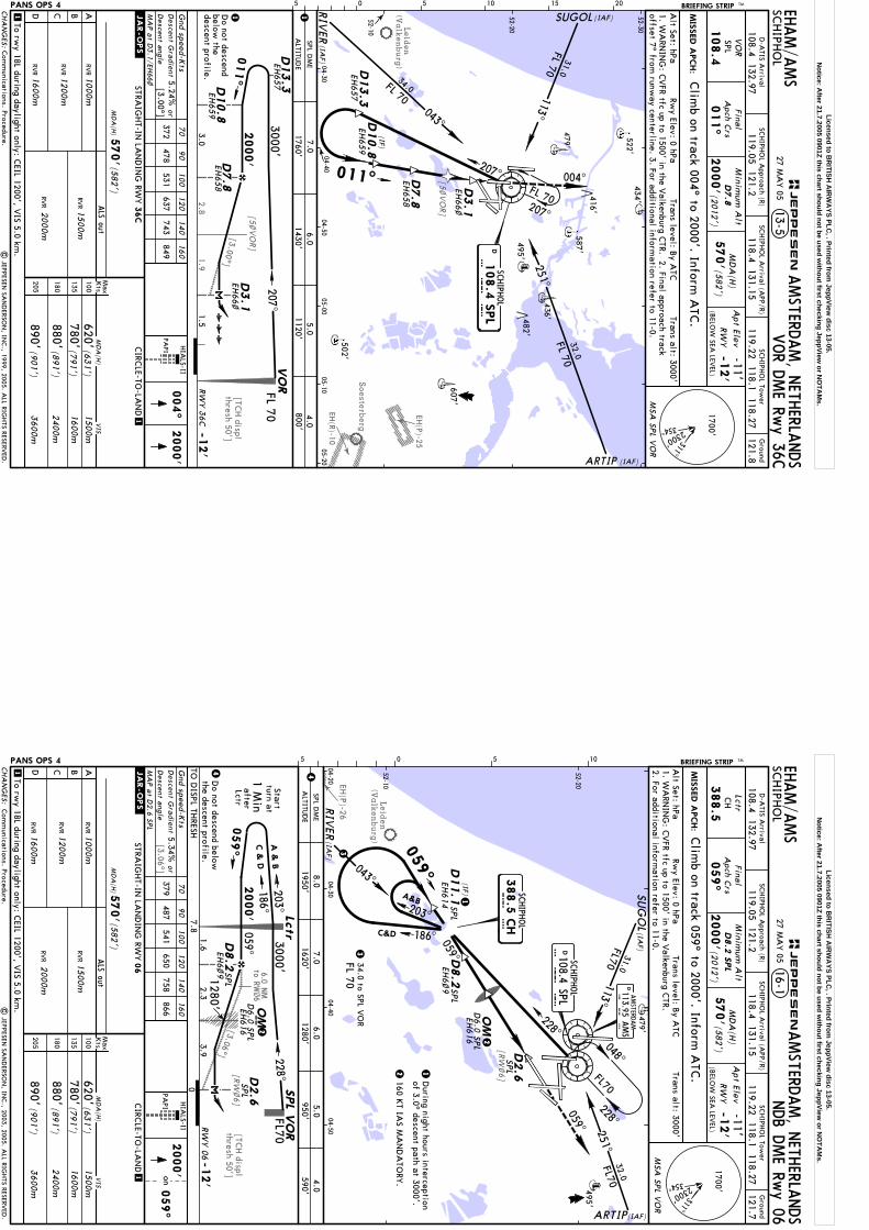
Leiden
(Valkenburg)
EH(R)-10
EH(P)-25
Soesterberg
1.9
[3.00^][TC
H displ
thresh 50']
2.8
[5~VO
R]
[5~VO
R]
Do not descend
below the
descent profile.
1. WA
RNIN
G: C
VFR tfc up to 1500' in the V
alkenburg CTR. 2. Final approach track
offset 7^ from runw
ay centerline. 3. For additional information refer to 11-0.
D7.8
D3.1
VO
R
D10.8
D13.3
D7.8
D13.3
D3.1
004^
D10.8
(IF)
SCHIPH
OL
108.4
SPL
DS P L
FL 70
011^M
ISSED A
PCH:
BRIEFING STRIP TM SCHIPH
OL
AMSTERD
AM, N
ETHERLA
NDS
VOR D
ME Rw
y 36C
VO
RSPL
108.4
011^
Minim
um A
lt
2000' D7.8
MD
A(H
)
570'(582
')
Apt Elev
-11'RW
Y-1
2'
MSA
SPL V
OR
Gnd speed-K
ts70
90
100
120
140
160
Descent G
radient
Clim
b on track 004^ to 2000'. Inform A
TC.
13-5
207^
PAPI
1
1
| JEPPESEN
SAN
DERSO
N, IN
C., 1999, 2005. A
LL RIGHTS RESERV
ED.
Alt Set: hPa
Rwy Elev: 0 hPa
Trans level: By A
TCTrans alt: 3000'
52-10
52-20
52-30
04-3004-40
04-5005-00
05-1005-20
ALS out
522'
479'
436'
495'
587'
482'
607'
502'
434'
004^
2000'
EHAM/A
MS
416'
FL 703000'
2000'
-12'
207^
011^
1.5
1
3.0
(IAF)
(IAF)
(IAF)
SUGOL
RIV
ER
ARTIP
CHA
NG
ES:
(BELO
W SEA
LEVEL)
311^
2300'
354^
1700'
ABCD
Max
Kts
CIRC
LE-TO-LA
ND
STRAIG
HT-IN
LAN
DIN
G RW
Y
100
135
180
205
MD
A(H
)
36C
570'(582
')
7.0SPL D
ME
6.05.0
4.01760'
1430'1120'
800'A
LTITUD
E
To rwy 18L during daylight only: C
EIL 1200', VIS 5.0 km
.
MD
A(H
)
2400m
3600m
(631')
(891')
(901')
620'
880'
890'
1500m
(791')780'
1600m
VIS
RVR
2000m
RVR1500m
1
RVR1000m
RVR1200m
RVR1600m
RWY 3
6C
Final
Apch C
rs
JEPPESEN
05 5 10 15 20.JAR-OPS.
[3.00^]D
escent angle
or372
478531
637743
849
(2012')
5.24%
SCHIPH
OL A
pproach (R)G
round
121.8SC
HIPH
OL Tow
erSC
HIPH
OL A
rrival (APP/R)
D-A
TIS Arrival
119.22 118.1 118.27119.05 121.2
108.4 132.97118.4 131.15
27 MA
Y 05
PANS OPS 4
Com
munications. Procedure.
207^
113^
FL 70
31.0
043^
FL 70
34.0
251^FL 7032.0
EH657
EH658
EH66~
EH659
EH657
EH659
EH658
EH66~
MA
P a
t D3.1/EH
66~
HIA
LS-II
Licensed to BR
ITISH A
IRW
AYS PLC
, . Printed from JeppView
disc 13-05.N
otice: After 21.7.2005 0901Z this chart should not be used w
ithout first checking JeppView or N
OTA
Ms.
Leiden
(Valkenburg)
EH(P)-26
[3.06^]
[TCH displ
thresh 50'][R
W~6]
[RW
~6]
[3.06^]
6.0 NM
to RW~6
Do not descend below
the descent profile.
1. WA
RNIN
G: C
VFR tfc up to 1500' in the V
alkenburg CTR.
2. For additional information refer to 11-0.
D2.6
D8.2
FL 70
SCHIPH
OL
108.4 SPLD
S P L
D2.6
TO D
ISPL THRESH
D8.2
2000'
Minim
um A
lt
44 MIS
SED A
PCH:
BRIEFING STRIP TM SCHIPH
OL
AMSTERD
AM, N
ETHERLA
NDS
Lctr
059^
MD
A(H
)
570'(582
')
Apt Elev
-11'RW
Y-1
2'
2000'
059^
on
Clim
b on track 059^ to 2000'. Inform A
TC.
16-1
PAPI
1 EHAM/A
MS
388.5
Alt Set: hPa
Rwy Elev: 0 hPa
Trans level: By A
TCTrans alt: 3000'
52-10
52-20
04-2004-30
04-4004-50
NDB D
ME Rw
y 06
CH
Gnd speed-K
ts70
90
100
120
140
160
Descent G
radient
ALS out
1
MSA
SPL V
OR
479'
495'
D8.2
SPL
SPL
SPLD
6.0
SPL
SPL
SPL
MA
P a
t D2.6 SP
L
34.0 to SPL VO
R
AMSTERD
AM
113.95 AMS
DA M S
059^
05 5 10
Final
Apch C
rs
Descent a
ngle
or5.34%
(2012')
SCHIPH
OL A
pproach (R)G
round
121.7SC
HIPH
OL Tow
erSC
HIPH
OL A
rrival (APP/R)
D-A
TIS Arrival
119.22 118.1 118.27119.05 121.2
108.4 132.97118.4 131.15
27 MA
Y 05
PANS OPS 4
| JEPPESEN
SAN
DERSO
N, IN
C., 2003, 2005. A
LL RIGHTS RESERV
ED.
Com
munications. Procedure.
2160 K
T IAS M
AN
DA
TORY
.
During night hours interception
of 3.0^ descent path at 3000'.
D6.0
SPL
228^048^
3
(IF)
EH6~
9
EH616 2
2
EH616
EH6~
9
HIA
LS-II
SPL
EH614
D11.1
379487
541650
758866
059^
OM
FL70
228^
SUG
OL
(IAF)3
RIV
ER(IA
F)
3.9RW
Y 0
6 -1
2'
0
Lctr
FL703000'
2000'7.8
2.3
Startturn at
1 Min
M OM186^203^
059^
228^
C &
D
A &
B
Lctr
1.6
ARTIP(IAF)
after
8.0A
LTITUD
E
CHA
NG
ES:
(BELO
W SEA
LEVEL)
311^
2300'
354^
1700'
To rwy 18L during daylight only: C
EIL 1200', VIS 5.0 km
.
1280'
ABCD
Max
Kts
MD
A(H
)
CIRC
LE-TO-LA
ND
STRAIG
HT-IN
LAN
DIN
G RW
Y
100
135
180
205
MD
A(H
)
2400m
3600m
(631')
(891')
(901')
620'
880'
890'
1500m
570'(582
')
(791')780'
1600m
VIS
1000mRV
R
1200mRV
R
1600mRV
R
RVR
2000m
RVR1500m
06
059^
059^
SPL DM
E7.0
6.05.0950'
4.0590'
1280'1620'
1950'
SPL V
OR
JEPPESEN
.JAR-OPS.
1
113^FL70
31.0
251^32.0
FL70
043^
1 SCHIPH
OL
C H
388.5
CH
C&D 186^
A&B203^
Licensed to BR
ITISH A
IRW
AYS PLC
, . Printed from JeppView
disc 13-05.N
otice: After 21.7.2005 0901Z this chart should not be used w
ithout first checking JeppView or N
OTA
Ms.
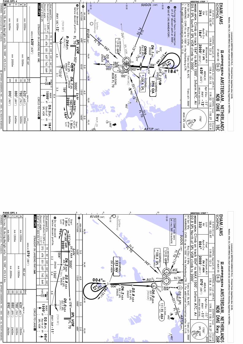
Leiden
(Valkenburg)
EH(P)-25
SPL VO
R
[TCH 50']
[3.00^]
[RW
18C
][3.00^]
[RW
18C
]
264^
1. WA
RNIN
G: C
VFR tfc up to 1500' in the V
alkenburg CTR.
2. For additional information refer to 11-0.
MIS
SED A
PCH:
BRIEFING STRIP TM SCHIPH
OL
AMSTERD
AM, N
ETHERLA
NDS
NDB D
ME Rw
y 18C
Lctr
184^
Minim
um A
lt
2000'
MD
A(H
)
620'(63
2')
Apt Elev
-11'RW
Y-1
2'
MSA
SPL V
OR
ALS out
Gnd speed-K
ts70
90
100
120
140
160
Descent G
radient
16-2
1
1
OA
395
Alt Set: hPa
Rwy Elev: 0 hPa
Trans level: By A
TCTrans alt: 3000'
52-10
52-20
52-30
04-2004-40
04-5005-00
05-10
522'
479'436'
495'
482'
683'
469'
EHAM/A
MS
184^
| JEPPESEN
SAN
DERSO
N, IN
C., 2001, 2005. A
LL RIGHTS RESERV
ED.
PAPI
1500'
184^
aton
D5.3
South of
Clim
b on track 184^ to MA
X 1500'. Inform
ATC
. At
MA
X
416'
D6.1
SPL
D5.3 SPL South of SPL V
OR clim
b to 2000'.
SPL VO
R SPL
MA
P a
t R-2
64 SP
L
Descent a
ngleor
(201
2')
Final
Apch C
rs
05 5 10 15 20
SCHIPH
OL
108.4 SPLDS P
L
5.24%372
478531
637743
849
HIA
LS-II
SCHIPH
OL A
pproach (R)G
round
121.8SC
HIPH
OL Tow
erSC
HIPH
OL A
rrival (APP/R)
D-A
TIS Arrival
119.22 118.1 118.27119.05 121.2
108.4 132.97118.4 131.15
27 MA
Y 05
PANS OPS 4
Com
munications. Procedure.
During night hours interception
of 3.0^ descent path at 3000'.
D9.2
SPL
EH62
5
2160 K
T IAS M
AN
DA
TORY
.
D5.3
SPL
EH63
8
2EH
63~
EH63
~
EH62
6D
4.0
SPL2
mD4.0
SPL
EH62
6
Do not descend
below descent profile.
184^002^
182^
184^
ARTIP (IAF)
SUGOL (IAF)
002^
A&B
C&D
311^
328^
(IAF)
RIV
ER
CHA
NG
ES:
(BELO
W SEA
LEVEL)
311^
2300'
354^
1700'
ABCD
Max
Kts
MD
A(H
)
CIRC
LE-TO-LA
ND
STRAIG
HT-IN
LAN
DIN
G RW
Y
100
135
180
205
MD
A(H
)
2400m
3600m
(631')
(891')
(901
')
620'
880'
890'
18C
1500m
620'(63
2')
To rwy 18L during daylight only: C
EIL 1200', VIS 5.0 km
.
(791')
780'1600m
VIS
1000m
RVR
1200m
RVR
1600m
RVR
RVR
2000m
RVR1500m
SPL DM
E2.0
3.04.0
5.01010'
1310'A
LTITUD
E3
184^
-12'
0
RW
Y 1
8C2.3
8.4
FL 70
2000'
A&
B
C&
D
328^311^1
84^
Lctr
1 Min
turn atStart
002^
4.0
Lctr
3000'3
1310'2.1
690'1650'
R-2
64
HO
LDIN
GM
IM FL 70
after
1
1
395 O
ASC
HIPH
OL
O A
SPL V
OR
SPL
D6.1
SPL
JEPPESEN
.JAR-OPS.
D113.95 A
MS
A M S
AMSTERD
AM
113^
FL 70
31.0
251^
32.0
FL 70
043^
34.0FL 70
OM
D6.1
SPL
OM
Licensed to BR
ITISH A
IRW
AYS PLC
, . Printed from JeppView
disc 13-05.N
otice: After 21.7.2005 0901Z this chart should not be used w
ithout first checking JeppView or N
OTA
Ms.
Leiden
(Valkenburg)
[3.00^]
[RW36R]
[TCH 50']
[RW36R]
[3.00^]
ALS out
Gnd speed-K
ts70
90
100
120
140
160
Descent G
radient
1
52-10
52-20
04-3004-40
04-5005-00
495'482'
1500'
004^
atPA
PIon
D2.8
North of
MA
X
SPL VO
R
SPL
AMSTERD
AM
113.95 AMS
DA M S
SCHIPH
OL
108.4 SPLD
S P L
05 5 10
Descent a
ngleor
EH635
5.24%372
478531
637743
849
HIA
LS-II
FL70
ABA
D8.7
SPL
MA
P a
t D0.0
ABA
/D2.7
SPL
D2.7
SPL
ABA
MIS
SED A
PCH:
BRIEFING STRIP TM SCHIPH
OL
AMSTERD
AM, N
ETHERLA
NDS
NDB D
ME Rw
y 36R
Lctr
004^
Minim
um A
lt
2000'
MD
A(H
)
570'(581
')
Apt Elev
-11'RW
Y-1
1'
16-3
NV
332
Alt Set: hPa
Rwy Elev: 0 hPa
Trans level: By A
TCTrans alt: 3000'
EHAM/A
MSClim
b on track 004^ to MA
X 1500'. Inform
ATC
. At
SPL V
OR
MSA
1. WA
RNIN
G: C
VFR tfc up to 1500' in the V
alkenburg CTR. 2. For additional inform
ation refer to 11-0.
D6.2
ABA
D2.8 SPL N
orth of SPL VO
R climb to 2000'.
Final
Apch C
rs
(2011')
178^
358^
EH63
7D
2.8
SPL
1
D8.4
ABA
EH635
EH636 ABA
ABA
D2.7
SPL
D8.7
SPL
D8.4
ABA
EH636
ILS DM
E reds zeroat rw
y 36R threshold.
SCHIPH
OL A
pproach (R)G
round
121.8SC
HIPH
OL Tow
erSC
HIPH
OL A
rrival (APP/R)
D-A
TIS Arrival
119.22 118.1 118.27119.05 121.2
108.4 132.97118.4 131.15
27 MA
Y 05
PANS OPS 4
Com
munications. Procedure.
| JEPPESEN
SAN
DERSO
N, IN
C., 2003, 2005. A
LL RIGHTS RESERV
ED.
ABA
D6.4
SPL
ABA
D6.4
SPL
SCHIPH
OL
004^
178^
004^
148^
SUG
OL
ARTIP
(IAF)
(IAF)
A&B
D0.0
ABA
DM
E5.0
4.03.0
2.01630'
1310'1000'
680'
332 N
VN V
ALTITU
DE
ABCD
Max
Kts
MD
A(H
)
CIRC
LE-TO-LA
ND
STRAIG
HT-IN
LAN
DIN
G RW
Y
100
135
180
205
MD
A(H
)
(631')
620'
36R
1500m
570' (581
')
(791')780'
1600m
VIS
1000mRV
R
1200mRV
R
1600mRV
RRV
R2000m
RVR1500m
1
004^
RIVER(IAF)
D6.2
2400m(891')
880'3600m
(901
')890'
.JAR-OPS.
(BELO
W SEA
LEVEL)
311^
2300'
354^
1700'
JEPPESEN
CHA
NG
ES:
To rwy 18L during daylight only: C
EIL 1200', VIS 5.0 km
.
ILS DM
E
A B A
111.95 ABA
Do not descend
below descent profile.
004^
-11'
RWY 3
6R 2.2
FL 70
2000'
C&
D
A&
B131^148^
004^
Lctr
1 Min
turn atStart
178^
3.8
Lctr
3000'
11260'2.4
after
SPL V
OR
D6.2
D0.0
D3.8
D3.8
113^FL 70
31.0
043^
FL 70
34.0
32.0
251^FL 70
131^
C&D
Licensed to BR
ITISH A
IRW
AYS PLC
, . Printed from JeppView
disc 13-05.N
otice: After 21.7.2005 0901Z this chart should not be used w
ithout first checking JeppView or N
OTA
Ms.

Leiden
(Valkenburg)
EH(P)-26
EH(P)-25
EH(P)-28
Refer toA
irportChart
Refer toM
issed Apch
above
(BELO
WSEE LEV
EL)See
table below
Rw
ys 0
4, 0
6, 0
9,
18R, 2
4, 2
7, 3
6C
Clim
b on Rwy track to 2000' and
inform A
TC.
Turn LEFT onto 160^ as soon as practicable and climb to 2000'.
Inform A
TC.
Turn RIGHT to intercept R-280 SPL and do not overshoot R-240 SPL.
Clim
b to 2000'. Inform A
TC.
WARN
ING: D
O
NO
T OVERSHO
OT
SPLVOR
1
Gnd speed-K
ts70
90
100
120
140
160
Descent G
radient
4.9%347
447496
595695
794
MIS
SED A
PCH:
Rwy 22:
Lighting -
SCHIPH
OL
AMSTERD
AM, N
ETHERLA
NDS
BRIEFING STRIP TM
MSA
SPL V
OR
1700'
2300'
354^
311^M
issed Approach - See below
Alt Set: hPa
Apt Elev: 0 hPa
Trans level: By A
TCTrans alt: 3000'
RA
DA
RA
pt Elev-11'
RW
Y- See below
By A
TC
Minim
um A
ltM
DA
(H)
Ground
1
108.4 132.97SC
HIPH
OL Tow
er
118.4 131.15SC
HIPH
OL A
rrival (APP/R)
SCHIPH
OL A
pproach (R)
18-1
52-10
52-20
52-30
04-2004-30
04-4004-50
05-0005-10
522'
479'436'
495'482'
683'
502'
469'
MA
P 1.5 N
M from
touchdown
| JEPPESEN
SAN
DERSO
N, IN
C., 2000, 2005. A
LL RIGHTS RESERV
ED.
2
EHAM/A
MS
SRE Rwys 04, 06, 09, 18C
,18R, 22, 24, 27, 36C
, 36R
121.7 121.8 121.9
2
Rwys 04, 06, 09, 18C
, 24, 27, 36C, 36R:
Rwy 18R:
416'
240^
05 5 10 15 20
Final
Apch C
rs
119.22 118.1 118.27
D-A
TIS Arrival
119.05 121.2
18-1ARefer to chart
For area of responsibility see 10-9.
For additional information
refer to 11-0. W
ARN
ING
: CVFR tfc up to
1500' in the Valkenburg
CTR. W
hen average surface w
ind velocity exceeds 30 KT,
moderate turbulence can be
expected on final apch for rw
y 24 and 27 from approx
D10.0 PA
M to D
8.0 PAM
.
Notes. Procedure.
27 MA
Y 05
.Eff.9.Jun.
059^
184^
OM
OM
268^
222^
222^ 109.15 SCH
S C H
ILS DM
E RWY 22
D117.8 PAM
PAMPU
S
P A M
-12'
09
PANS OPS 4CHA
NG
ES:
RWY
2000'
1800'1500'
1200'900'
600'FA
F 6.76.0
5.04.0
3.02.0
2427
-11'-14'
-12'
04-13'
06-12'
22
FOR LA
ND
ING
MIN
IMUM
S REFER TO 18-1A
Min
imum
Alt/
NM
004^
004^
004^ 108.75 SAS A
ILS DM
E RWY 3
6C
900'600'
FAF 10.0
6.05.0
4.03.0
2.0M
inim
um
Alt/
NM
SRE
7.08.0
9.0
1200'1500'
1800'2100'
2400'2700'
3000'
ELEV
184^
SRE R
wys 1
8C, 2
2, 3
6R
-12'-13'
18C18R
36C-12'
36R-11'
D108.4 SPLSC
HIPH
OL
S P L
SCHIPH
OL
W P
376 W
P
SCHIPH
OL
332 NV
N V388.5 C
HSC
HIPH
OL
C H
D113.95 A
MS
A M S
AMSTERD
AM
184^ 110.1 VPB
V P
BILS D
ME RW
Y 18R
395 OA
SCHIPH
OL
O A
JEPPESEN
184^ 109.5 SPILS RW
Y 18C
S P
059^ 110.55 KAG
K A G
ILS DM
E RWY 0
6
A B A
004^ 111.95 ABA 268^ 111.55 BV
BB
V B
ILS DM
E RWY 3
6R
ILS DM
E RWY 27
Licensed to BR
ITISH A
IRW
AYS PLC
, . Printed from JeppView
disc 13-05.N
otice: After 21.7.2005 0901Z this chart should not be used w
ithout first checking JeppView or N
OTA
Ms.
SCHIPH
OL
AMSTERD
AM, N
ETHERLA
NDS
18-1A
LAN
DIN
G M
INIM
UM
S
STRAIG
HT-IN
LAN
DIN
G
ABCD
ALS out
1
MD
A(H
)570'(582
')
SRE 0
6
MD
A(H
) 570'(583
')
SRE 0
4ALS out
MD
A(H
)570'
SRE 0
9
(582')
.JAR-OPS.
.JAR-OPS.
RVR1200m
RVR1600m
RVR
RVR2000m
RVR1500m
RVR2000m
RVR1500m
RVR1400m
RVR1500m
RVR1800m
RVR1600m
RVR1500m
RVR2000m
| JEPPESEN
SAN
DERSO
N, IN
C., 2000, 2005. A
LL RIGHTS RESERV
ED.
EHAM/A
MS
STRAIG
HT-IN
LAN
DIN
GCIRC
LE-TO-LA
ND
ABCD
MD
A(H
)
MD
A(H
)
ALS out
(582')
570'
780'(791')1600m
1
880'(891')2400m
890'(901
')3600m
.JAR-OPS.
VIS
620'(631')
1500m
RVR1500m
RVR1000m
RVR1200m
RVR1600m
RVR2000m
ALS out
MD
A(H
)
RVR1000m
RVR1400m
RVR
RVR2000m
RVR1500m
900m
RVR1800m
400'(412')
SRE 1
8C
ABCD
ALS out
MD
A(H
)600'(614')
SRE 2
2
MD
A(H
) 450'(4
63')
ALS out
MD
A(H
)570'
SRE 2
4
(581')
RVR2000m
RVR1500m
RVR2000m
RVR1500m
RVR
RVR 1200m
RVR1600m
RVR1500m
RVR2000m
ALS out
MD
A(H
)
RVR
1200mRV
R
1600mRV
RRV
R2000m
RVR1500m
570'(582
')
STRAIG
HT-IN
LAN
DIN
GSRE 1
8R
RVR1400m
RVR1500m
RVR1800m
RVR1600m
SRE 2
7
Max
Kts
100
135
180
205
SRE 3
6C
MD
A(H
)
ALS out
(581')
570'
RVR1500m
RVR1000m
RVR1200m
RVR1600m
RVR2000m
SRE 3
6R
To rwy 18L during daylight only: C
EIL 1200', VIS 5.0 km
.
1000m
1000m1000m
27 MA
Y 05
Minim
ums SRE 18R.
.Eff.9.Jun.
CHA
NG
ES:
JEPPESEN
PANS OPS 4
Licensed to BR
ITISH A
IRW
AYS PLC
, . Printed from JeppView
disc 13-05.N
otice: After 21.7.2005 0901Z this chart should not be used w
ithout first checking JeppView or N
OTA
Ms.