11. WIND SYSTEMS - Indiana University Bloomingtongeog109/topics/11_windsystems/stu… · ·...
16
G109 11. Wind Systems 1 11. WIND SYSTEMS A&B: Ch 8 (p 214-238) Concepts: I. Scale II. Differential heating III. Wind direction 1. Scales: Three major divisions Space Time Micro meters seconds - minutes Meso kilometers seconds - hours Macro Synoptic Planetary 100 - 1000 km 1000 + km - Global days days - weeks 2. Differential Heating Spatially - get differences in surface heating e.g. Micro: grass - concrete - Lab 5 Meso: land - lake Macro: equator - poles • T difference 3. Wind direction Based on where the wind is coming from
Transcript of 11. WIND SYSTEMS - Indiana University Bloomingtongeog109/topics/11_windsystems/stu… · ·...

G109 11. Wind Systems
1
11. WIND SYSTEMS A&B: Ch 8 (p 214-238) Concepts: I. Scale
II. Differential heating III. Wind direction 1. Scales: Three major divisions
Space Time Micro meters seconds - minutes Meso kilometers seconds - hours Macro Synoptic
Planetary 100 - 1000 km
1000+km - Globaldays
days - weeks 2. Differential Heating Spatially - get differences in surface heating
e.g. Micro: grass - concrete - Lab 5
Meso: land - lake Macro: equator - poles • T difference
3. Wind direction Based on where the wind is coming from

G109 11. Wind Systems
2
e.g. sea breeze - air coming from the sea valley breeze - air coming from the valley Micro-scale
Example: Turbulent eddies - small whirls of air - dust devils - gusts
Meso-scale a. Land-sea breeze (land - lake breeze) Dail y T difference between land and sea Daytime:
• land heated more intensively compared to water (remember temperature section of course)
http://www.indiana.edu/~geog109/topics/temp/temp.htm

G109 11. Wind Systems
3
• • • Pressure gradient force: H ⇒ L
Nighttime: • Reverse • Land cools more rapidly than water • Warmer over the water • Land breeze

G109 11. Wind Systems
4
Sea breeze - can have a significant modifying effect on
the T in coastal areas e.g. Lake breeze - Chicago Size of breeze varies. b. Mountain - Valley Breeze Day:
• slopes of mountains get more intense heating than air at the same elevation over the valley floor
• Valley breeze • Most common in
summer
Sunset/Night • Rapid cooling of
slopes • Mountain breeze • Most common in
winter •

G109 11. Wind Systems
5
⇒ seasonal preference for winds c. Foehn, Chinook, (Santa Ana) winds Chinook – Rockies (Montana and Wyoming) Foehn - Alps, N.Z. Santa Ana – California –special case (high pressure)
• Migration of surface and upper level weather systems
• Low pressure system on the lee side of a mountain barrier
⇒ Pulls the air across • Adiabatically warms
as it comes down mountain
• Usually occur winter /spring
When T cold, melts snow • T can rise by 20 C

G109 11. Wind Systems
6
Special cases of ⇒ d. Katabatic Winds --- from local cooling over high- elevation plateau
• downslope wind • winter time • Bora - Adriatic sea Mistral - France

G109 11. Wind Systems
7
Bora--Adriatic Sea: Cold, north to northeast katabatic wind flowing through mountain passages into the Adriatic Sea east of Italy. Bora--Adriatic Sea may be associated with stormy weather, with winds reaching 100 kts or more. Bora-Adriatic Sea develops in the winter when cold polar air builds over the Balkans and flows katabatically through the valleys of the Dinaric Alps and into the Adriatic Sea.
G109 11. Wind Systems
8
Mistral -- France
Mistral: Cold, northerly katabatic wind flowing into the Gulf of Lion from the southern coast of France. Mistrals are most common during winter and spring. In the winter, wind speeds can reach over 100 knots off the southern coast of France. Gale-force Mistrals often develop when cyclogenesis occurs over the Gulf of Genoa with the passage of the 500 mb trough (see forces and pressure notes) through eastern France.

G109 11. Wind Systems
9
Synoptic and Planetary Scale Wind systems Larger scale circulations influence the smaller scale winds i.e. it is important what the synoptic situation is Global Circulation
• Differential heating between equator and poles ⇒ pressure differences
Three cell circulation model
• Realistic model – base on earth rotation and energy gradient between the equator and the poles

G109 11. Wind Systems
10
• Hadley Cell : Equator and Subtropics --thermally driven circulation—intense heating upward expansion
o ITCZ – Very strong zone of low pressure at the equator --Convergence--( small deflection -- Tradewinds)
• Ferrel Cell : Midlatitudes (NH-deflection to right—SH deflection to left--westerlies) • Polar Cell : Poles –thermally driven circulation—Very cold condition--high surface pressure--sinking air—strong deflection

G109 11. Wind Systems
11
Close approximation to real world patterns Reality
ITCZ Trade winds Hadley Circulation Cell
Break down of Ferrel and Polar cells Surface winds
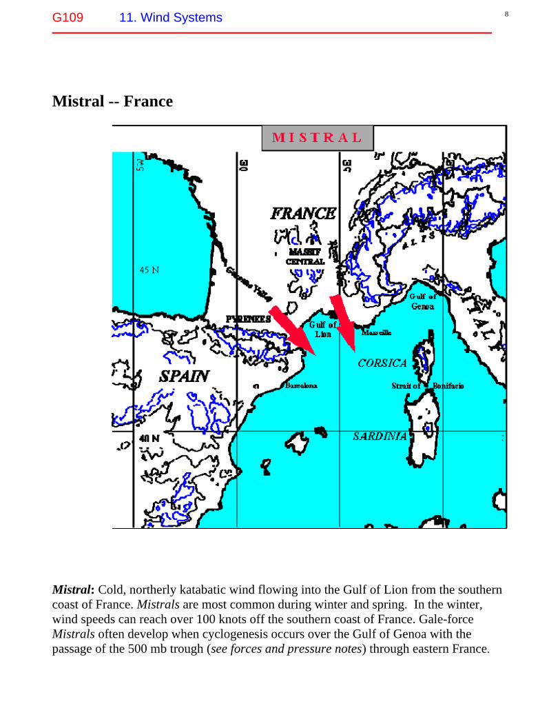
Westerlies esp. SH • Real world --- alternating semi-permanent high and low pressure cells
January
G109 11. Wind Systems
12
July

G109 11. Wind Systems
13
Jet stream • An area of increased wind speeds
o Narrow band: 100 - 500 km wide o 9 – 12 km above sea level o Speeds: 200 - 500 km h-1
40F 45F 75F 80F • • • • • • • Most powerful jetstream: polar jet stream
o Moves north and south with the seasons

G109 11. Wind Systems
14
World Jet stream positions 11/14/05

G109 11. Wind Systems
15
US Jet Stream Position 11/21/05 http://www.weatherimages.org/data/imag192.html

G109 11. Wind Systems
16
US Jet Stream Position 11/05/2007
http://www.nws.noaa.gov/outlook_tab.php


![[XLS]iara.wvu.edu · Web view1 11 2 11 3 12 4 11 5 11 6 11 9 11 10 11 11 11 21 11 22 11 23 11 24 11 25 11 26 11 27 11 28 11 30 12 40 11 50 11 51 11 52 11 53 11 61 11 62 11 63 11 90](https://static.fdocuments.net/doc/165x107/5b1a62177f8b9a41258d8f49/xlsiarawvuedu-web-view1-11-2-11-3-12-4-11-5-11-6-11-9-11-10-11-11-11-21.jpg)