11 · The Culmination of Greek Cartography in Ptolemy · 11 · The Culmination of Greek Cartography...
24
11 · The Culmination of Greek Cartography in Ptolemy o. A. w. DILKE WITH ADDITIONAL MATERIAL SUPPLIED BY THE EDITORS By the time of Marinus of Tyre (fl. A.D. 100) and Clau- dius Ptolemy (ca. A.D. 90-168), Greek and Roman in- fluences in cartography had been fused to a considerable extent into one tradition. There is a case, accordingly, for treating them as a history of one already unified stream of thought and practice. Here, however, though we accept that such a unity exists, the discussion is fo- cused on the cartographic contributions of Marinus and Ptolemy, both writing in Greek within the institutions of Roman society. Both men owed much to Roman sources of information and to the extension of geograph- ical knowledge under the growing empire: yet equally, in the case of Ptolemy especially, they represent a cul- mination as well as a final synthesis of the scientific tradition in Greek cartography that has been traced through a succession of writers in the previous three chapters. The remarkable influence of Ptolemy on the devel- opment of European, Arabic, and ultimately world car- tography can hardly be denied. 1 Through both the Math- ematical Syntaxis (a treatise on mathematics and astronomy in thirteen books, hereafter called the Al- magest)2 and the Geography (in eight books), it can be said that Ptolemy tended to dominate both astronomy and geography-and hence their cartographic manifes- tations-for over fourteen centuries. It is true that during the period from the second century A.D. to the early fifteenth century Ptolemy's geographical writings ex- erted relatively little influence on Western cartography, though they were known to Arab astronomers and geo- graphers. 3 The Almagest, although translated into Latin by Gerard of Cremona in the twelfth century, appears to have had little direct influence on the development of cartography. With translation of the text of the Geo- graphy into Latin in the early fifteenth century, however, the influence of Ptolemy was to structure European car- tography directly for over a century. In the history of the transmission of cartographic ideas it is indeed his work, straddling the European Middle Ages, that pro- vides the strongest link in the chain between the know- ledge of mapping in the ancient and early modern worlds. Notwithstanding his immense importance in the study of the history of cartography, Ptolemy remains in many respects a complicated figure to assess. Many questions about his work remain unanswered. Little is known about Ptolemy the man, and neither his birthplace nor his dates have been positively established. 4 Moreover, in relation to the cartographic component in his writings, we must remember that no manuscript earlier than the twelfth century A.D. has come down to us, and there is no adequate modern translation and critical edition of the Geography.5 Perhaps most serious of all for the stu- dent of mapping, however, is the whole debate about the true authorship and provenance of the general and regional maps that accompany the several versions of the Byzantine manuscripts (pp. 268-74 below). AI- 1. Some existing authorities tend to eulogize Ptolemy excessively by viewing his work out of context of the sources available to him. See, for example, Lloyd A. Brown, The Story of Maps (Boston: Little, Brown, 1949; reprinted New York: Dover, 1979), chap. 3, esp. 79- 80. Others criticize his "egregious errors": see R. R. Newton, The Crime of Claudius Ptolemy (Baltimore: Johns Hopkins University Press, 1977); cf. note 31 below. 2. Ptolemy, Almagest, trans. G. J. Toomer (London: Duckworth, 1984); Toomer translates the Greek title as "mathemat- ical systematic treatise." The Arabic title given as al-mjsty (consonantal skeleton only) comes from a Greek form, f,LE"YL<T'T'1'h "the greatest [trea- tise]" see Toomer Almagest, 2. All translations from the Almagest appearing in this text are taken from Toomer's edition. 3. See volume 2 of the present History. 4. G. J. Toomer, "Ptolemy," in Dictionary of Scientific Biography, 16 vols., ed. Charles Coulston Gillispie (New York: Charles Scribner's Sons, 1970-80), 11:186-206, esp. 186-87. 5. Editions of Ptolemy's Geography include: Claudii Ptolemaei Geo- graphia, 3 vols., ed. C. F. A. Nobbe (Leipzig: C. Tauchnitz, 1843- 45), reprinted in one volume with an introduction by Aubrey Diller (Hildesheim: Georg alms, 1966); Claudii Ptolemaei Geographia, 2 vols. and tabulae, ed. Karl Miiller (Paris: Firmin-Didot, 1883-1901); Claudii Ptolemaei Geographiae Codex Urbinas Graecus 82, 2 vols. in 4, ed. Joseph Fischer, Codices e Vaticanis Selecti quam Simillime Expressi, vol. 19 (Leiden: E. J. Brill; Leipzig: O. Harrassowitz, 1932); and Geography of Claudius Ptolemy, trans. Edward Luther Stevenson (New York: New York Public Library, 1932). Because of the com- plexity and often technical nature of the Geography, editions vary substantially in coverage and quality and therefore no single edition was selected for use in the History. The Nobbe and Miiller editions were consulted for making translations; Stevenson, the only complete English edition, is in many respects inadequate and was not used. Unless otherwise indicated, the translator for all quotations from the Geography is James Lowe, Ph.D. candidate (1985) at the University of Wisconsin-Madison. When appropriate or necessary, specific edi- tions are cited in the footnote. 177
Transcript of 11 · The Culmination of Greek Cartography in Ptolemy · 11 · The Culmination of Greek Cartography...

11 · The Culmination of Greek Cartography in Ptolemyo. A. w. DILKE
WITH ADDITIONAL MATERIAL SUPPLIED BY THE EDITORS
By the time of Marinus of Tyre (fl. A.D. 100) and Claudius Ptolemy (ca. A.D. 90-168), Greek and Roman influences in cartography had been fused to a considerableextent into one tradition. There is a case, accordingly,for treating them as a history of one already unifiedstream of thought and practice. Here, however, thoughwe accept that such a unity exists, the discussion is focused on the cartographic contributions of Marinus andPtolemy, both writing in Greek within the institutionsof Roman society. Both men owed much to Romansources of information and to the extension of geographical knowledge under the growing empire: yet equally,in the case of Ptolemy especially, they represent a culmination as well as a final synthesis of the scientifictradition in Greek cartography that has been tracedthrough a succession of writers in the previous threechapters.
The remarkable influence of Ptolemy on the development of European, Arabic, and ultimately world cartography can hardly be denied.1 Through both the Mathematical Syntaxis (a treatise on mathematics andastronomy in thirteen books, hereafter called the Almagest)2 and the Geography (in eight books), it can besaid that Ptolemy tended to dominate both astronomyand geography-and hence their cartographic manifestations-for over fourteen centuries. It is true that duringthe period from the second century A.D. to the earlyfifteenth century Ptolemy's geographical writings exerted relatively little influence on Western cartography,though they were known to Arab astronomers and geographers.3 The Almagest, although translated into Latinby Gerard of Cremona in the twelfth century, appearsto have had little direct influence on the development ofcartography. With translation of the text of the Geography into Latin in the early fifteenth century, however,the influence of Ptolemy was to structure European cartography directly for over a century. In the history ofthe transmission of cartographic ideas it is indeed hiswork, straddling the European Middle Ages, that provides the strongest link in the chain between the knowledge of mapping in the ancient and early modernworlds.
Notwithstanding his immense importance in the studyof the history of cartography, Ptolemy remains in manyrespects a complicated figure to assess. Many questions
about his work remain unanswered. Little is knownabout Ptolemy the man, and neither his birthplace norhis dates have been positively established.4 Moreover,in relation to the cartographic component in his writings,we must remember that no manuscript earlier than thetwelfth century A.D. has come down to us, and there isno adequate modern translation and critical edition ofthe Geography.5 Perhaps most serious of all for the student of mapping, however, is the whole debate aboutthe true authorship and provenance of the general andregional maps that accompany the several versions ofthe Byzantine manuscripts (pp. 268-74 below). AI-
1. Some existing authorities tend to eulogize Ptolemy excessively byviewing his work out of context of the sources available to him. See,for example, Lloyd A. Brown, The Story of Maps (Boston: Little,Brown, 1949; reprinted New York: Dover, 1979), chap. 3, esp. 7980. Others criticize his "egregious errors": see R. R. Newton, TheCrime of Claudius Ptolemy (Baltimore: Johns Hopkins UniversityPress, 1977); cf. note 31 below.
2. Ptolemy, Ptolemy~s Almagest, trans. G. J. Toomer (London:Duckworth, 1984); Toomer translates the Greek title as "mathematical systematic treatise." The Arabic title given as al-mjsty (consonantalskeleton only) comes from a Greek form, f,LE"YL<T'T'1'h "the greatest [treatise]" see Toomer Almagest, 2. All translations from the Almagestappearing in this text are taken from Toomer's edition.
3. See volume 2 of the present History.4. G. J. Toomer, "Ptolemy," in Dictionary of Scientific Biography,
16 vols., ed. Charles Coulston Gillispie (New York: Charles Scribner'sSons, 1970-80), 11:186-206, esp. 186-87.
5. Editions of Ptolemy's Geography include: Claudii Ptolemaei Geographia, 3 vols., ed. C. F. A. Nobbe (Leipzig: C. Tauchnitz, 184345), reprinted in one volume with an introduction by Aubrey Diller(Hildesheim: Georg alms, 1966); Claudii Ptolemaei Geographia, 2vols. and tabulae, ed. Karl Miiller (Paris: Firmin-Didot, 1883-1901);Claudii Ptolemaei Geographiae Codex Urbinas Graecus 82, 2 vols.in 4, ed. Joseph Fischer, Codices e Vaticanis Selecti quam SimillimeExpressi, vol. 19 (Leiden: E. J. Brill; Leipzig: O. Harrassowitz, 1932);and Geography of Claudius Ptolemy, trans. Edward Luther Stevenson(New York: New York Public Library, 1932). Because of the complexity and often technical nature of the Geography, editions varysubstantially in coverage and quality and therefore no single editionwas selected for use in the History. The Nobbe and Miiller editionswere consulted for making translations; Stevenson, the only completeEnglish edition, is in many respects inadequate and was not used.Unless otherwise indicated, the translator for all quotations from theGeography is James Lowe, Ph.D. candidate (1985) at the Universityof Wisconsin-Madison. When appropriate or necessary, specific editions are cited in the footnote.
177
178
though Bagrow, Crone, and other authors claim it cannot be established whether maps were drawn in connection with the Geography in the second century A.D.,
a rereading of the early Greek version may demonstratethat such maps existed.6 There is as yet no general agreement on this question, and it illustrates how the wholesubject of Ptolemy's place in cartographic development-over the long period of his influence-must behandled with caution. Here we try to bypass the wideswaths of speculation in the earlier literature and toconcentrate on reconstructing Ptolemy's work directlyfrom the textual evidence. In particular, we will examinePtolemy's review of the mapping of Marinus of Tyre,the instructions Ptolemy provides for drawing celestialglobes and terrestrial maps, and the likely content of hisown maps (if they existed) as inferred from the evidenceof the coordinate tables and the maps in the Greek manuscripts of the thirteenth and fourteenth centuries.
UPDATING THE WORLD MAP: PTOLEMY'SCRITICISM OF MARINUS OF TYRE
As the Roman world continued to expand its territorialinfluence during the first century A.D., and as previousgains were consolidated into the administration of theempire, there could have been some pressure on scholarsand administrators to update those maps that were usedby the bureaucracy or displayed in public places. Theflow of new geographical knowledge can be traced toboth military and commercial enterprises. The fleet ofGnaeus Iulius Agricola (A.D. 40-93) had sailed aroundthe British Isles, and it was claimed that the island ofThule had been seen in the distance; 7 it was in factMainland, the largest of the Shetland Isles. The campaigns against Germany or Dacia, and the Roman explorations into central Africa or to the sources of theNile in Ethiopia, had likewise made areas familiar thathad previously been considered far outside the inhabitedworld. Or yet again, by the age of Ptolemy, Chinesemerchants were exporting silk to Rome and to otherparts of Europe, either by land through Asia, or by seathrough the Indian Ocean and the Persian Gulf or theRed Sea. 8 The potential sources for the mapmaker werethus greatly enriched. In the Roman world, just as muchas in the Age of Great Discoveries, in a society that wasalready familiar with maps (see chap. 12 below), thisnew information in turn created incentives for revisingmaps to accord with the new knowledge of reality.
It is in this general context of an expanding worldthat we can place the specific attempts of Marinus ofTyre to modify existing maps from new discoveries. Little is known about Marinus, but the busy Phoenicianport from which he originated, maintaining extensive
Cartography in Ancient Europe and the Mediterranean
commercial contacts across the known world, suggestssome of the channels by which new knowledge may havereached him.9 Ptolemy devoted a great deal of space inthe Geography to a thorough criticism of Marinus'swork, describing him as the "latest," in the sense of themost recent, "of the contemporary geographers"10 andlater drawing extensively on his materials in compilinghis own Geography. The importance of Marinus in theprocess of updating the world map, although he was notthe first to attempt this task, lay in his critical approachto existing maps, even those he had compiled himself,which he revised as new information became available.As Ptolemy suggested in book 1 of the Geography, muchof Marinus's working life was devoted to this task: "Heobviously included many accounts in addition to thosealready known before his time. He also considered worthy of correction those accounts which both he (the firsttime) and others had carelessly trusted; this we can seefrom his editions (of which there are many) of the correction of the map."11 This passage should not be readto imply that Ptolemy was uncritical of Marinus, andsubsequent chapters are devoted to correcting, or tomaking more intelligible, the text that confronted him.Yet if Marinus was sometimes obscure, Ptolemy revealedhimself to be a true cartographer, almost in the moderndefinition of that word, by focusing primarily on thetechniques by which maps were compiled rather thansolely on their geographical content. As a result, thereemerges from Ptolemy's critique of Marinus a clear perception of three major cartographic problems confronting the mapmaker of that age.
The first of these problems, in a long lineage of Greekwork, concerned the size and position of the inhabitedworld. For these calculations Marinus had adopted,largely uncritically, 180,000 stades as the value for thecircumference of the earth. He simply said that "one
6. See below, pp. 189-90; Gerald R. Crone, Maps and Their Makers:An Introduction to the History of Cartography, 5th ed. (Folkestone,Kent: Dawson; Hamden, Conn.: Archon Books, 1978), 3; Leo Bagrow, History of Cartography, rev. and en!. R. A. Skelton, trans.D. L. Paisey (Cambridge: Harvard University Press; London: C. A.Watts, 1964), 34-37.
7. Tacitus Agricola 10; see The Agricola [and] The Germania, trans.Harold Mattingly, rev. S. A. Handford (Baltimore: Penguin Books,1970).
8. John Ferguson, "China and Rome," in Aufstieg und Niedergangder romischen Welt, ed. Hildegard Temporini and Wolfgang Haase(Berlin: Walter de Gruyter, 1972-), 2.9.2 (1978): 581-603; ManfredG. Raschke, "New Studies in Roman Commerce with the East," inAufstieg und Niedergang (above), 2.9.2 (1978): 604-1361, and mapappendix following.
9. No other Greek writer apart from Ptolemy mentions Marinus ofTyre, nor does any Latin writer; for an Arabic reference see volume2 of the present History.
10. Ptolemy Geography 1.6.1 (note 5).11. Ptolemy Geography 1.6.1 (note 5).
The Culmination of Greek Cartography in Ptolemy
part [i.e., degree] contains just about 500 stades,,,12 thusmaking his measurement the same as the smaller of thoseestimates ascribed to Posidonius.
According to Marinus, the north-south width of theinhabited world extended from the parallel throughThule, at 63°N, to the parallel through the country ofthe Ethiopians, named Agisymba, and the promontoryof Prasum. 13 This southerly parallel, which Marinus saidwas below the winter tropic, is in fact the southerntropic, at 24°S. As for the island of Thule, which Pytheasand Eratosthenes located at 66°N, on the polar circle,Marinus did not explain (or at least Ptolemy does nottell us) why he moved it to 63°N. Marinus thereforeattributed 87° or 43,500 stades to the latitudinal breadthof the known world. He estimated its length at fifteenhours of longitude14 between two meridians, that is,225° or 90,000 stades along the Rhodian parallel, 36°N,on which he had assumed one degree of longitude wasabout 400 stades.
So the inhabited world according to Marinus occupiedwell over a quarter of the terrestrial globe. His map alsodiffered greatly from earlier maps in two respects. First,it was drawn on both hemispheres, even though mostof it lay in the Northern Hemisphere. Second, the extentof the ocean between the extreme east and west edgesof the inhabited world was considerably reduced: it wasdepicted as 135° longitude or 54,000 stades along theRhodian parallel, as compared with 225° longitude or90,000 stades from Spain to China by land.
It is true that Marinus or his source made some astronomical observations, quoted by Ptolemy in Geography 1.7.4 and following sections; but Ptolemy dismisses these as inconclusive. Marinus's method was simply to employ the various records of travelers and merchants, by converting into stades the number of daysnecessary to go by land or sea from one place to another.When the number of stades seemed excessive to him, hearbitrarily reduced it to suit his conceptions. However,Marinus was the first geographer to extend the knownworld significantly by including in his map the easternpart of Asia, "from the Stone Tower to Sera, the capitalof the Seres, a journey of seven months.,,15 Likewise, heintegrated the part of Africa lying south of the Garamantes (a people living in the Sahara) into the worldview, writing about Agisymba, far toward the south andbeyond the equator.
A second cartographic problem in which Ptolemyshared an interest with Marinus-and indeed may havebuilt on the foundations he had provided-was that ofmap projections. Apparently Marinus never completedthe final revision of his map of the world, for, as Ptolemyputs it, "he himself says, even in the last edition he hasnot come to the point of revision in which he correctsthe climata and the hours.,,16 Yet even if this exercise
179
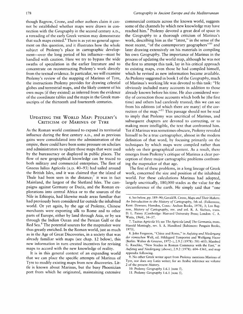
in mathematical geography did not reach its final cartographic expression, Marinus had nevertheless made acareful study of the problem of representing a portionof the globe on a plane. Like Eratosthenes and Strabo,he adopted a rectangular projection in which the parallels and meridians were all drawn as straight parallellines, the meridians being perpendicular to the parallels.But unlike Eratosthenes, who had selected only a fewparallels and a few meridians at irregular distances, Marinus seems to have used a complete network of parallelsand meridians at regular distances from one another (fig.11.1). In this system all the parallels are the same length:Marinus gave them the length of the parallel throughRhodes. According to Ptolemy, "he kept only the parallelpassing through Rhodes proportional to the meridianaccording to the approximate 4:5 ratio.... he had noconcern for any of the others with respect to their proportionality or spherical shape."17 As a result, the distances on the equator fell short by one-fifth of theircorrect measurement, and the distances on the parallelthrough Thule were increased by four-fifths. 18 Indeed,Ptolemy stated, "Marinus devoted considerable attention to this and generally found fault with all the systemsof the plane-maps; nevertheless he used a system of representation especially unsuitable for keeping distancesproportional. ,,19 Its overall effect was to make Marinus's
12. Ptolemy Geography 1.7.1 (note 5, Muller edition).13. As has been previously mentioned, Agisymba refers to central
Africa and Cape Prasum is somewhere near Zanzibar, south of Rhapta(possibly Cape Delgado).
14. One hour is fifteen degrees of longitude; but one degree oflongitude is equal to 500 stades on the equator (if the circumferenceof the earth is taken as 180,000 stades) and only 400 stades on theRhodian parallel.
15. Ptolemy Geography 1.11.3 (Muller edition), 1.11.4 (Nobbe edition) (note 5). Sera is the capital of the silk country, China. There issome discrepancy, even within Ptolemy, as to the exact location ofthe Stone Tower; see J. Oliver Thomson, History of Ancient Geography (Cambridge: Cambridge University Press, 1948; reprinted NewYork: Biblo and Tannen, 1965),307-9.
16. Ptolemy Geography 1.17.1 (note 5, Muller edition).17. Ptolemy Geography 1.20 (note 5). Muller, in his edition, cor
rectly explains E.7rVTe.'nxpTo" here as 4:5. The literal sense (cf. E.7rLTPLTO",E.1TL1TEf.L1TTO") is "a quarter in addition," which could mean 11/4: 1 or,as here, 1: 11/4. A Greek-English Lexicon, 2 vols., compo Henry GeorgeLiddell and Robert Scott, rev. and augmented Henry Stuart Jones(Oxford: Clarendon Press, 1940), translates the adjective wrongly as"ratio of 4:3." (However the Supplement to these volumes, publishedin 1968, amends the statement to read "ratio of 5:4"; p. 61.) E. L.Stevenson, drawing on a Renaissance Latin translation, brings in anonexistent character Epitecartus. What Ptolemy means is that Marinus treated the whole world, for the sake of simplification, as if itwere like the area around Rhodes, where a degree of longitude wastaken as 400 stades, of latitude as 500.
18. Ptolemy Geography 1.20.7 (note 5); see also Armando Cortesao,History of Portuguese Cartography, 2 vols. (Coimbra: Junta de Investiga~6es do Ultramar-Lisboa, 1969-71), 1:98 n. 52.
19. Ptolemy Geography 1.20.3 (note 5).

180
maps of the inhabited world misleading "and, in manycases, they [the editors following Marinus] go far astrayfrom the general consensus because of the inconvenientand disjointed nature of the directions, as any experi-
d ,,20ence person can see.
63°r---.--.-------r----.-------.---.---_r-----,----.-------,----.-------,~-+--+----+--+---+--+-----!~-+--+----+-+-------l600N
1---+--+---+--+---+--+--1---+--+---+--+--------t45°
6°t---+--+---+--+---+--q--t----t---t----;---t---;I---+--+---+-+---t--+--+---+--+---+--+-----t 30°
I---+--+---+--+---+--+--I---+--+---+--+--------t 15°
FIG. 11.1. MARINUS'S PROJECTION RECONSTRUCTEDFROM PTOLEMY'S DESCRIPTION. Marinus appears tohave used a complete network of parallels and meridians inwhich all the parallels were the same length as that of Rhodes,thereby introducing considerable deformation.After Otto Neugebauer, A History of Ancient MathematicalAstronomy (New York: Springer-Verlag, 1975), fig. 68.
A third and final problem in Marinus's maps relatedto errors accumulated in the compilation of geographicaldetail from written commentaries. Ptolemy had discovered that, as a result of uncritical copying, some of thecommentaries could not be satisfactorily collated withthe content of the maps. He explained that "the constanttransfer [of data] from earlier to later models bringsabout gradual change that usually culminates in a vastdiscrepancy" and added that many of those workingwith Marinus's map did not use the latest edition.21 Itseems that mapmakers in Ptolemy's day-and not onlyMarinus in this respect-usually worked in isolation,incorporating at random the modifications required intheir maps as a result of the growth of geographicalknowledge.
A combination of such inaccuracies led Ptolemy toreject Marinus's work as a cartographer. As alreadynoted, he believed the information in many of Marinus'smaps was neither coherent nor practical. For example,in one work Marinus might correct the latitudes only,in another the longitudes; but the places taken into account were not the same in both works, so that it wasdifficult to find a place with both sets of coordinatescorrectly rendered. Consequently Ptolemy-although heevidently made extensive use of Marinus's materialregarded the drawing of a map according to Marinus'scommentaries as a hopeless undertaking.
PTOLEMY'S INSTRUCTIONS FOR MAPMAKING
Ptolemy's most crucial legacy to the long-term development of cartography is the instructions he codified as
Cartography in Ancient Europe and the Mediterranean
to how maps of various types should be drawn. Theseinstructions are scattered in various texts, but if broughttogether they may be said to constitute a technical manual of some sophistication for would-be mapmakers.Moreover, in association with such theoretical guidance,Ptolemy also compiled at length the empirical substancefor the content of such maps. As is well known, thesesurvive in the form of coordinate lists of both celestialand terrestrial positions, so that if Ptolemy stopped shortof drawing maps or having them drawn for him, whichnow appears unlikely,22 he at least left sufficient materials for their construction by others. Indeed, his workwas so unambiguously cartographic in its intention thatthe absence of graphic records would do nothing todiminish its interest for the history of cartography. Tomake a simple analogy to modern cartographic databases, we might say that Ptolemy transmitted his cartographic knowledge in digital rather than graphic form,leaving his successors to recreate the images he so clearlyenvisaged as the end product of the mapping process.
While it is generally believed that Ptolemy was bornin Upper Egypt and subsequently lived in Alexandria,he is known to us mainly through his various writingssurviving first in a number of Byzantine recensions. 23
The traditional literature of the history of cartographywith its emphasis on geographical maps-has tended tooverlook the fact that Ptolemy was a polymath, rangingover topics as diverse as astronomy, mathematics, physics, optics, harmonics, chronology, and geography. AsCortesao has pointed out, however, quite a few of theseworks contain material relevant to his interests in mapmaking. For example, Ptolemy's Analemma deals withthe theory of the gnomon and orthographic projection;Planisphaerium examines stereographic projection; andTetrabiblos, the large treatise on astrology, also has references to geography.24 It is, however, through the Almagest and through the Geography, which in certainmanuscripts of the Byzantine recensions contain worldor regional maps or both, that his influence on cartographic development was largely transmitted.
So interrelated are the concepts and facts in these lasttwo works that in the history of cartography they haveto be considered together. In the Almagest Ptolemytaught how to draw a celestial globe; in the Geography,how to draw the map of the inhabited world on a globe(said to be simple and similar to the mapping of thecelestial sphere) or on a plane surface. In both works he
20. Ptolemy Geography 1.18.3 (note 5).21. Ptolemy Geography 1.18.3 (Muller edition), 1.18.2-3 (Nobbe
edition) (note 5).22. See below, pp. 189-90.23. See below, pp. 268-72.24. Cortesao, History of Portuguese Cartography, 1:92-93 (note
18), and Toomer, "Ptolemy" (note 4).

The Culmination of Greek Cartography in Ptolemy
presented a complete series of coordinates. Since theseconstitute the only sets of coordinates to survive fromclassical antiquity, they can justly be said, despite certainimperfections, to mark a critical datum line in the development of celestial and terrestrial cartography.
THE CELESTIAL GLOBE IN THE ALMAGEST
Ptolemy, who made astronomical observations in Alexandria between A.D. 127 and 141, was in the first instance an astronomer. His major purpose was to gatheras much information as possible and to organizeit into an exhaustive synthesis that could be used as anessential tool by every student in this field. So he startedby composing a treatise in which he studied all the problems concerning the motion of the celestial bodies, andthe relation between the motionless earth and the moving sphere of the sky.
A systematic star catalog, following certain technicalrules, is required to make a celestial map or globe.25
Ptolemy's catalog was derived from that of Hipparchus,and like Hipparchus, according to Toomer, Ptolemy describes the stars "as if they were drawn on the inside ofa globe, as seen by an observer at the centre of thatglobe, and facing towards him.,,26 All the known starsin the heavens were grouped into constellations: twentyone constellations lay north of the zodiac, twelve on thezodiac, and fifteen south of it; so forty-eight constellations containing 1,022 stars were listed in the wholecatalog. For each star, Ptolemy indicated the longitudeand latitude in relation to the ecliptic rather than theequator, so that the positions of the stars would notchange owing to the precession of the equinoxes: thelatitudes do not vary, and one need only add the valuesof the precession for any time to find the longitudes.
In a few cases Ptolemy had to amend the naming ofthe positions of the stars within the constellations tomake them relate more closely to the outlines of humanfigures or animals usually sketched to represent them:
Futhermore, the descriptions which we have appliedto the individual stars as parts of the constellationare not in every case the same as those of our predecessors (just as their descriptions differ from theirpredecessors'): in many cases our descriptions aredifferent because they seemed to be more natural andto give a better proportioned outline to the figuresdescribed. Thus, for instance, those stars which Hipparchus places "on the shoulders of Virgo" we describe as "on her sides" since their distance from thestars in her head appears greater than their distancefrom the stars in her hands, and that situation fits [alocation] "on her side," but is totally inappropriateto [a location] "on her shoulders."27
The names Ptolemy gave to the stars were thus slightly
181
different from the forms found in Hipparchus. But asPtolemy explained: "One has a ready means of identifying those stars which are described differently [by others]; this can be done immediately simply by comparingthe recorded positions. ,,28 Their relative positions were,in fact, to remain unaltered on his celestial globe, andit is only the names that were subject to variation.
Having listed all the stars that he wanted to take intoaccount, Ptolemy explained in great detail how to makea solid sphere as an image of the sky. It was advisableto select a dark globe, its color symbolizing the nightsky and allowing the stars to be seen clearly. Two points,diametrically opposed, would indicate the poles of theecliptic. Two great circles would then be drawn, one ofthem passing through these poles, the other, perpendicular to it, representing the zodiac (one of the points ofintersection is selected as the starting point for graduating the ecliptic into 360 degrees).
Nor did Ptolemy neglect to provide practical, mechanical instructions for the globe maker.29 It would beconvenient, he suggested, to attach two semicircles tothe globe (Rings A and B in fig. 11.2). so that the relationship between equatorial coordinates and eclipticcoordinates could be demonstrated.
When the exact place of the star has been located,Ptolemy continued, it should be marked by a yellowpoint or, for some stars, the colors noted in the starcatalog, of a size appropriate to the brightness or themagnitude of the star. As for the figures of the constellations, they should be dimly sketched schematically,hardly visible against the dark background of the sphere,so that they do not conceal the stars.30
Thus Ptolemy's celestial globe differed greatly fromthose described by Eudoxus or Aratus or carried by theFarnese Atlas. In those earlier periods, astronomers preferred to group stars into constellations so as to be ableto name and identify them, hence the emphasis on theoutlines of the constellations. By Ptolemy's day, however, the identification of stars had become less dependent on the constellations, for they could be located-
25. Ptolemy Almagest 7.5-8.1 (note 2), contains the tabular layoutof the constellations.
26. Toomer, Ptolemy~s Almagest, introduction, p. 15 (note 2).27. Ptolemy Almagest 7.4 (note 2).28. Ptolemy Almagest 7.4 (note 2).29. For a full account of the instruments Ptolemy describes, see
D. R. Dicks, "Ancient Astronomical Instruments," Journal of the British Astronomical Association 64 (1954): 77-85.
30. Ptolemy Almagest 8.3 (note 2). For a detailed technical interpretation of some of the Greek at this point, see the translation andnotes in Toomer, Ptolemy~s Almagest, 404 n. 179 and 405 nne 180,181 (note 2).

182
on the sphere as in the catalog-by giving the coordinatepositions of each individual star.31
FIG. 11.2. PTOLEMY'S INSTRUCTIONS FOR CONSTRUCTING A STAR GLOBE. The Almagest contains explicit instructions for constructing a celestial globe from ecliptic coordinates. Ring A, on the axis PP', is fixed at the solstitialpoint, 12°20'E of the meridian of Sirius, which represents itsposition at that time (first year of the principate of AntoniusPius, A.D. 137). This fixes the axis of the sidereal coordinatesystem with Sirius as the reference star. Equatorial coordinatescould be mechanically converted from the ecliptic coordinateswith the help of ring B, which rotates freely around the axisNN', which is 23°51' distant from the axis PP' to allow forthe obliquity of the ecliptic.After Otto Neugebauer, A History of Ancient MathematicalAstronomy (New York: Springer-Verlag, 1975), fig. 79.
THE CLIMATA IN THE ALMAGEST
In book 2 of the Almagest, Ptolemy turned to a standardproblem in mathematical geography: establishing theposition of the inhabited world on the terrestrial globe,and its relation to the celestial sphere, together with thedistribution of the climata. First of all, he asserted that"our part of the inhabited world is approximatelybounded by one of the two northern quarters.,,32 Thenhe decided to compute systematically the celestial phenomena relating to several parallels of the northernhemisphere, noting for each one data such as the heightof the pole above the horizon, the ratios of gnomon toshadow on solstitial and equinoctial days, and the lengthof the longest day. All these values were obtained bycalculation (not by observation), as Ptolemy explainedin later chapters.
Cartography in Ancient Europe and the Mediterranean
Ptolemy's tables were almost certainly inspired by thetable of climata33 drawn up by Hipparchus, in whichsimilar information could have been found. But whereasHipparchus dealt with parallels spaced at one degree (or700 stades) apart, Ptolemy used in his calculations adifference of one-quarter of an hour (or sometimes halfan hour or even an hour) in the length of the longestday from one parallel to the next. This implies that theparallels employed may not have been equidistant, andhence Ptolemy was obliged to increase the difference oftime for the northern parallels.
Curiously enough, Ptolemy mentioned the traditionalhypothesis of a probable inhabited world along the terrestrial equator, on the grounds that these latitudes enjoya milder climate than the areas near the tropics. Yet atthe same time he accepted that "what these inhabitedregions are we have no reliable grounds for saying. Forup to now they are unexplored by men from our partof the inhabited world, and what people say about themmust be considered guesswork rather than report. In anycase, such, in sum, are the characteristics of the parallelbeneath the equator.,,34 From the equator to the polarcircle, Ptolemy listed thirty-three parallels: the equatoris first, followed by the parallel with a 121/4-hour longestday, at 4 1/4oN, which was assigned to Taprobane (SriLanka); the last in the series, with a 24-hour longestday, at approximately 661/6°N, was not related to aknown country. The last parallel to relate to the knowninhabited world was the 21-hour parallel, at 641/2°N, inthe location of unknown Scythian tribes; it was next tothe parallel through Thule (day of 20 hours, at 63°N).Beyond the 24-hour parallel, Ptolemy referred to theparallels representing the longest day of one to sixmonths at monthly intervals, the last, of course, beingunder the pole. It may be noted that the countries ortowns related to each parallel were either the traditionalones, for the central part of the map, or, for the southernor northern parts, places that are difficult to identify. Inany case, such places were used only for reference inrelation to the climata.
31. Various scholars, and lately Newton, Crime ofClaudius Ptolemy(note 1), have accused Ptolemy of not having made the observationshe claims to have made and of having falsified records obtained byhis predecessors in order to bolster his own theories. But in introducinghis star catalog, Ptolemy does not conceal his debt to his predecessors,or at any rate to Hipparchus, even if he claims to have verified theirobservations; no doubt he used celestial globes, quite usual in his time,to choose coherent sets of coordinates. His originality consists in having preferred ecliptic coordinates to equatorial ones and in havingprovided complete sets of coordinates so that anyone should be ableto draw constellations on a globe.
32. Ptolemy Almagest 2.1 (note 2).33. Ernst Honigmann, Die sieben Klimata und die 1T6AEL~ E1T(<Tl1JJ..OL
(Heidelberg: Winter, 1929).34. Ptolemy Almagest 2.6 (note 2).

The Culmination of Greek Cartography in Ptolemy
In other chapters of book 2, Ptolemy selected only afew climata to draw up tables of astronomical phenomena according to latitude. In book 2, chapter 8, elevenclimata are enumerated, from the equator (12-hour) tothe Tanais (Don) River (17-hour), with a regular increaseof half an hour in the length of the longest day. Laterin book 2, chapter 12, he reduced to seven the numberof selected climata, and these indeed reappear frequentlyin the mappaemundi of the later Middle Ages:-the 13-hour parallel, through Meroe-the 13 1/2-hour parallel, through Syene-the 14-hour parallel, through Lower Egypt-the 141/2-hour parallel, through Rhodes-the 1S-hour parallel, through the Hellespont-the 1S 1/2-hour parallel, through the central part of the
Black Sea-the 16-hour parallel, through the river Borysthenes.
In the commentary on the last (astronomical) table,cited above from the Almagest, Ptolemy announced hisproject of composing a Geographike hyphegesis (Manual of geography), now usually known as the Geography:
Now that the treatment of the angles [between ecliptic and principal circles] has been methodically discussed, the only remaining topic in the foundations[of the rest of the treatise] is to determine the coordinates in latitude and longitude of the cities in eachprovince which deserve note, in order to calculate the[astronomical] phenomena for those cities. However,the discussion of this subject belongs to a separate,geographical treatise, so we shall expose it to viewby itself [in such a treatise], in which we shall usethe accounts of those who have elaborated this fieldto the extent which is possible. We shall [there] listfor each of the cities its distance in degrees of thatmeridian from the meridian through Alexandria, tothe east or west, measured along the equator (for that[Alexandria] is the meridian for which we establishthe times of the positions [of the heavenly bodies]).35
Ptolemy was to wait some twenty years before executinghis project.
THE GEOGRAPHY
As with the Almagest, there is no doubt that the Geography was deliberately planned as a manual for mapmakers. In its opening paragraph Ptolemy explains itsscope by defining "geography" as "a graphic representation of the whole known part of the world, along withthe things occurring in it. ,,36 Later he explains the difference between geography and chorography thus: "Theaim of chorography is a consideration of the parts, aswould be the case for someone depicting [i.e., paintingor drawing] just the ear or eye; but the aim of geographyis a consideration of the whole, as it is for those (to use
183
the same analogy) who depict the entire head."3?In drawing up his catalog of stars, Ptolemy had simply
gathered all the available information and arranged itinto a systematic table of coordinates enabling anyoneto make a celestial globe. In like manner in his Geography, he collected information from his predecessors,especially from the most immediate, Marinus of Tyre,38and arranged it within a systematic table of coordinates.Thus, Ptolemy believed, it would be easy for anyone todraw a map of the inhabited world, or regional mapswith the main towns and characteristic features of thecountries.
In outlining his aim to provide mapmakers with anappropriate tool in handy form, Ptolemy seems to havebeen fully aware of deficiencies in some of his information. This is shown in his declaration: "But as for[the degrees of latitude and longitude of] places not visited in this manner, it is advisable, because of the scarcityand uncertainty of the accounts, to base the reckoningmore completely upon the proximity of reliably knownpositions or configurations, so that none of the thingsinserted to fill up the whole world may have an undefinedplace. ,,39 It is clear that Ptolemy believed it was preferable for mapmakers to locate as many places as possible in the known world, even where the authority forthis location was shaky, perhaps recognizing intuitivelythat only thus would such maps eventually be challengedand become more complete.
The contents of the Geography are as follows:
Book 1 Introduction, including map projections andcriticism of Marinus.
Book 2 Ireland, Britain, the Iberian Peninsula, Gaul,Germany, the upper Danube provinces, Dalmatia.
Book 3 Italy and adjacent islands, Sarmatia in Europe, the lower Danube provinces, Greece and adjacent areas.
Book 4 North Africa (west-east), Egypt, interiorLibya (Africa), Ethiopia.
Book 5 Asia Minor, Armenia, Cyprus, Syria, Palestine, Arabia Petraea, Mesopotamia, Arabia Deserta, Babylonia.
Book 6 The former Persian empire apart from areasalready covered (west-east); the Sacae and Scythiabordering on that empire.
Book 7 India, the Sinae, Taprobane, and adjacentareas. Summary of world map. Description of armilIary sphere including the map of the inhabitedearth. Summary of regional sections.
Book 8 Brief survey of the twenty-six regional maps.
35. Ptolemy Almagest 2.13 (note 2).36. Ptolemy Geography 1.1.1 (note 5, Muller edition).37. Ptolemy Geography 1.1.2 (note 5).38. Ptolemy Geography 1.6-7 (note 5).39. Ptolemy Geography 2.1.2 (note 5).

184 Cartography in Ancient Europe and the Mediterranean
FIG. 11.3. A RECONSTRUCTION OF THE WORLD OFCLAUDIUS PTOLEMY. After Edward Herbert Bunbury, AHistory ofAncient Geography among the Greeks and Romans
In the case of this survey of the regional maps in book8, standard information is given for each map. In turn,Ptolemy indicates the proportion of one degree on thecentral parallel of the map in question to one degree ofmeridian; he describes roughly the outlines of the map;and then he locates the main towns by a pair of coordinates. But he expresses latitude in terms of length ofthe longest day and longitude in number of hours eastor west of the Alexandrian meridian.4o
SIZE AND DIMENSIONS OF THE INHABITED WORLD IN
THE GEOGRAPHY
Ptolemy criticized Marinus for having extended the inhabited world too far. Accepting the Thule parallel(63°N) as the northern limit, he rejected the southerntropic (24°S) as the southern limit and located the regionof Agisymba and the promontory of Prasum, the farthestknown countries, on the parallel opposite the onethrough Meroe (which one may call Anti-Meroe), at 16°25'S or about 8,200 stades south of the equator (fig.11.3). Thus the whole latitudinal extent of the inhabitedworld was reduced to 79°25' or nearly 40,000 stades(Ptolemy used the value he had borrowed from Marinusof 180,000 stades for the circumference of the earth).
from the Earliest Ages till the Fall of the Roman Empire, 2ded., 2 vols. (1883; republished with a new introduction byW. H. Stahl, New York: Dover, 1959), map facing p. 578.
Similarly, the length of the inhabited world was reduced from Marinus's fifteen-hour longitude to twelvehours or 180°, from the Fortunate Isles (the Canaries)in the extreme west to Sera and Cattigara in the extremeeast.41 Ptolemy claimed to have accomplished this reduction by examining and comparing land and sea journeys, but it is likely that he relied more on guessworkthan on sound calculation. So he fixed the length of theinhabited world at 72,000 stades, calculated along the36°N parallel passing through Rhodes, on which onedegree of longitude was reckoned to be 400 stades.42
For the distance between the Fortunate Isles and theEuphrates, Ptolemy indicated 72° or 28,800 stades;43from the Euphrates to Sera or Cattigara, 105°15' or42,100 stades via the Stone Tower.44
40. In the Almagest 2.13 a prime meridian of Alexandria is proposed, but when Ptolemy came to write the Geography, the extremewesterly meridian of the Fortunate Isles was preferred-at least inbooks 2-7-to allow all longitudes to be expressed as east of this line.A remnant of the earlier system is found in the Geography, book 8.See Toomer, Ptolemy's Almagest, 130, n. 109 (note 2).
41. Ptolemy Geography 1.11 (note 5). Cattigara, south of Sera, maybe somewhere near the modern city of Hanoi, although other theorieshave been advanced; see pp. 198-99 below.
42. Ptolemy Geography 1.11.1,1.12.10 (note 5).43. Ptolemy Geography 1.12 (note 5).44. Ptolemy Geography 1.12.9 (note 5).

The Culmination of Greek Cartography in Ptolemy
By such calculations in his Geography, Ptolemy thusaccepted that the inhabited world extended south of theequator in latitude; in longitude, as proposed by Posidonius, it now constituted one-half of the NorthernHemisphere.45 On the whole, in spite of his criticism ofMarinus's map, Ptolemy adopted most of the information transmitted by him, modifying the sections necessary to fit his own concept of the size of the inhabitedworld: "But were we to find nothing lacking from hislast arrangement, it would have been sufficient for us toconstruct a map of the inhabited world just from thesecommentaries, and waste no time on anything else. ,,46
MAP PROJECTIONS
Since it was usual to draw the map of the inhabitedworld on a plane surface, Ptolemy examined differenttypes of map projection and their ability to maintain thecharacteristics of a sphere. With hindsight it may be saidthat this was perhaps his most vital contribution to thelong-term development of the mathematical basis ofmapmaking. Ptolemy, revealing a clear conceptual insight into the fundamental problem of map projections,writing of globes and of flat maps respectively, says:
Each of these conceptual systems would have its advantages. The first system, which locates the map ona sphere, obviously preserves the likeness of theworld's shape and obviates the need for any manipulation of it; on the other hand, it hardly providesthe size necessary for containing most of the thingsthat must be set in place, nor can it let the entire mapbe seen from one vantage point: instead, one mustmove either one's own eyes or the sphere in order toview the rest.
The second system, representation on a flat surface,avoids the aforementioned shortcomings altogether.But it lacks some sort of method for preserving thelikeness of the spherical shape whereby it might makethe distances recorded on its flat surface as proportional as possible to the true distances.47
The Geography contains a detailed exposition of foursystems of map projection: (1) a projection with straightand perpendicular parallels and meridians, like that ofMarinus; (2) a projection with straight converging meridians and curved parallels; (3) a projection with curvedconverging meridians and curved parallels; and (4) aspecial projection of the globe as viewed from a distance. 48 This whole subject has generated a substantialliterature since the nineteenth century, much of it mathematically confusing, with an emphasis on the modification of the Ptolemaic map projections during the European Renaissance.49 Ptolemy'S explanations certainlyneed to be handled with caution, and there is the danger,as Keuning argues, of defining his methods too literallyin terms more appropriate to the formality of modernprojections.50
185
Marinus's Projection
Marinus had selected for his world map what could bedefined (in modern terms) as a rectangular projection,represented in a graticule by straight parallel meridiansand straight parallels orthogonal to the meridians, forming a grid of rectangles. The scale along the parallel ofRhodes (36°N) and along all meridians was assumed tobe constant. Marinus had also assumed the length of theparallel of Rhodes-the central parallel of the inhabitedworld-to be approximately four-fifths the length of theequator (and thus also of any meridian great circle);Ptolemy modified this slightly by expressing the proportion of the length of a degree of longitude on thecentral parallel to a degree of latitude on the meridianas being 93: 115, which very closely approximates cos36° == 0.809.
This method of projection was to be used for someversions of the regional or provincial maps that wereattached to the later texts of the Geography. But Ptolemyrejected the system for the world map on the groundsthat the various parallels appear in its construction tobe of the same length, causing severe deformation awayfrom the central parallel. He calculated the proportionof the length of the parallel of Thule to the length of theequator, for example, as 52:115 (cos 63° == 0.454), yetit is represented by a line of the same length as theequator on the Marinus projection.51
Ptolemy's First Projection
To overcome this disadvantage, Ptolemy devised a system of projection, usually called his first projection, inwhich the meridians were to be drawn as straight linesfrom a theoretical point (not the North Pole) and theparallels as arcs of a circle with the same point as center.This, in fact, was the projection usually employed for
45. Strabo Geography 2.3.6; see The Geography ofStrabo, 8 vols.,trans. Horace Leonard Jones, Loeb Classical Library (Cambridge: Harvard University Press; London: William Heinemann, 1917-32). Alsosee Strabo, Geographie, ed. Fran~ois Lasserre, Germaine Aujac, et al.(Paris: Belles Lettres, 1966-).
46. Ptolemy Geography 1.6.2 (note 5).47. Ptolemy Geography 1.20.1-2 (note 5).48. In identifying these four systems we follow Otto Neugebauer,
A History ofAncient Mathematical Astronomy (New York: SpringerVerlag, 1975), 879-959. See also Cortesao, History of PortugueseCartography, 1:97-109 (note 18), who gives a full summary withextensive quotations of Ptolemy's ideas from the Geography.
49. These projections will be dealt with fully in the present History,volume 3.
50. See Johannes Keuning, "The History of Geographical Map Projections until 1600," Imago Mundi 12 (1955): 1-24, who writes (p.9), "The Ptolemaic projections appear very like conical projections,though they are not. In antiquity there was no question of projectingon a cone or on a cylinder."
51. Ptolemy Geography 1.20 (note 5).

186
constructing the map of the inhabited world associatedwith the later manuscripts. Its advantage over Marinus'sprojection was not only that it maintained constant scalealong the central parallel (Rhodes) and the meridians(as had Marinus's) but that the proportion of the lengthof the parallel of Thule to the length of the equator wasalso correct. This scale could not, of course, be the sameas along the parallel of Rhodes, but since this representedthe traditional central parallel, and so many distanceswere known along it, Ptolemy scaled the whole map toit:
Since it is impossible for all of the parallels to keepthe proportion that there is in a sphere, it will bequite sufficient to observe this proportion in the parallel circle running through Thule and the equinoctial, in order that the sides of our map that representlatitude may be proportionate to the true and naturalsides of the earth.
The parallel passing through Rhodes must be inserted because on this parallel very many proofs ofdistances have been registered, and inserted in rightrelation to the circumference of the greatest circle,following in this Marinus, who gave the ratio for theequal circumferences of the equator (and the meridians) to the parallel of Rhodes as 5 :4. By thus doing,we shall ensure that the longitude of our earth, whichis the better known, will be in right proportion tothe latitude.52
The frame of the map-following the traditional proportions of the inhabited world-would have to be rectangular in shape, the center of the circles representingthe parallels lying outside this framework for the map(fig. 11.4). Within it would have to be drawn thirty-sixplus one meridians one-third of an hour of longitude(5°) apart. For the section of the map south of the equator he advised drawing one parallel only in addition tothe parallel of Anti-Meroe (see above, p. 184): the parallel passing through Rhapta promontory and Cattigara,at a half-hour distance from the equator, which wouldbe the same length as the parallel opposite at g025 'N(see table below).
To mark the localities that were to be placed on themap, Ptolemy continued, the mapmaker should take anarrow ruler, equal in length to the radius of the circleused to draw the equator. He should attach it to thepoint taken as the center of the curved parallels, so thatit could be made to coincide with any given meridian.Then, using the graduations in latitude inscribed on theruler and the graduations in longitude inscribed on theequator, he should quite easily be able to mark the townsor geographical features in their true places.53 We cansee from these details that even in the event Ptolemy maynot have illustrated his projections either in an actualmap or in the form of a diagram of the meridians and
Cartography in Ancient Europe and the Mediterranean
Parallel Length of Longest Day Degrees
North of Equator1 12 hr 15 min 4°15'N2 12 hr 30 min 8°25'N3 12 hr 45 min 12°30'N4 Meroe 13 hr 16°25'N5 13 hr 15 min 200 15'N6 Syene 13 hr 30 min 23°50'N7 13 hr 45 min 27°10'N8 14 hr 300 20'N9 14 hr 15 min 33°20'N10 Rhodes 14 hr 30 min 36°N11 14 hr 45 min 38°35'N12 15 hr 400 55'N13 15 hr 15 min 43°05'N14 15 hr 30 min 45°N15 16 hr 48°30'N16 16 hr 30 min 51°30'N17 17 hr 54°N18 17 hr 30 min 56°10'N19 18 hr 58°N20 18 hr 30 min 61°N21 Thule 19 hr 63°N
South of Equator
Rhapta 12 hr 30 min 8°25'5Anti-Meroe 13 hr 16°25'5
parallels, his instructions for future mapmakers werenonetheless quite explicit. At the same time, it is hardto imagine how such precise instructions could have beencompiled without resorting to graphic experiments.
Ptolemy's Second Projection
Despite its improvements over Marinus's projection,Ptolemy's simple first projection was not without itsdrawbacks. First, the north and south portions of themeridians form acute angles at the equator; second, theproportions of the parallels between Thule and the equator are not the same as on the sphere. So Ptolemy proposed a further projection-often known as his secondprojection-to alleviate these problems.54 It was to be
52. Ptolemy Geography 1.21.2 (note 5), translated by o. A. W.Dilke. The translation in Stevenson, Geography of Claudius Ptolemy(note 5), following Latin versions, gives a completely incorrect rendering. For another example of Stevenson's unacceptable translation,see note 103 below.
53. Ptolemy Geography 1.24.7 (note 5).54. Ptolemy Geography 1.24.9-20 (note 5). Marie Armand Pascal
d'Avezac-Macaya, in his pioneer study, Coup d~oeil historique sur laprojection des cartes de geographie (Paris: E. Martinet, 1863), gaveit the name "homeotheric projection"; it may also be regarded as theancestor of the Bonne projection. D'Avezac-Macaya's study was originally published as "Coup d'oeil historique sur la projection des cartesde geographie," Bulletin de la Societe de Geographie, 5th ser., 5(1863): 257-361, 438-85.

The Culmination of Greek Cartography in Ptolemy
constructed with curved parallels and meridians (fig.11.5). According to Ptolemy, its aim was to give the linesrepresenting the meridians the appearance they have onthe sphere when viewed by an observer looking directlyat the center of the map.55
o 10,000 20,000 30,000 40,000 StadesL L----__~ I I
FIG. 11.4. PTOLEMY'S FIRST PROJECTION. The frame ofthe inhabited world (ABr~) is shown superimposed upon aconic graticule with straight converging meridians and parallels as arcs of circles. Although Ptolemy explained that itwas easier to construct and use than his second projection (seefig. 11.5), it did not reflect the spherical shape of the earth aseffectively, and only two parallels (as well as all the meridians)maintained their true lengths.After Erich Polaschek, "Ptolemaios als Geograph," in PaulysRealencyclopadie der classischen Altertumswissenschaft, ed.August Pauly, Georg Wissowa, et al. (Stuttgart: j. B. Metzler,1894-), suppl. 10 (1965): 680-833, fig. 4.
The central parallel of the map was designed to runthrough Syene, at 23°50' north of the equator. Syenewas approximately midway between the parallels ofThule (63°N) and Anti-Meroe (16°25'S). From a centeroutside the rectangular panel on which the map was tobe drawn (H in fig. 11.5), Ptolemy advised that it wouldbe convenient to plot the arcs of the circles representingthe main parallels: Thule, Syene, and Anti-Meroe.56 Second, the thirty-six meridians would be drawn as circulararcs, eighteen on each side of the straight central meridian at five-degree intervals (everyone-third hour). Circular meridians were possible, since only three parallelswere chosen along which to preserve the true proportions of distances. It was left to later commentators todiscover that if the arcs were not circular, all of theparallels in such a projection-not just three-could bedrawn preserving their true lengths. Apparently the firstperson to employ this procedure was Henricus MartellusGermanus on his manuscript world map of about 1490,
187
10,000 20,000 30,000 40,000 Stades'-----_-...J1l--_-...J1l--_-...J1__--J1
FIG. 11.5. PTOLEMY'S SECOND PROJECTION. Constructed with curved meridians and parallels, this was designedto alleviate some of the problems associated with Ptolemy'sfirst projection (see fig. 11.4). It was especially popular withlater editors of the Geography in the Renaissance.After Erich Polaschek, "Ptolemaios als Geograph," in PaulysRealencyclopadie der classischen Altertumswissenschaft, ed.August Pauly, Georg Wissowa, et al. (Stuttgart: j. B. Metzler,1894-), suppl. 10 (1965): 680-833, fig. 5.
now at Yale University. In 1514 Johannes Werner, alongwith his new translation of book 1 of the Geography,added a theoretical discussion of Ptolemy's second projection.57
Ptolemy's exposition of his second projection ends ona remarkably pragmatic note. Although he believed itoffered a better theoretical solution, the task of drawingthe map was rendered more difficult. The curved meridians in particular meant that the geographical detailscould no longer be plotted, as with the first projection,by the straightforward use of a ruler. Ptolemy thus re-
55. Ptolemy Geography 1.24.9 (note 5).56. The parallels would thus be drawn in approximately the fol
lowing proportions: 5 the equator, 2.25 the Thule parallel, 4.35 theSyene parallel, and 4.4 the Anti-Meroe parallel.
57. Ptolemy, Geographia, ed. and trans. Johannes Werner (Nuremburg, 1514). See also the discussion by Neugebauer, History ofAncientMathematical Astronomy, 885-88 (note 48), who does not, however,mention the Martellus map.

188 Cartography in Ancient Europe and the Mediterranean
Thule Y
A
FIG. 11.7. PTOLEMY'S THIRD PROJECTION AS SEEN BYTHE OBSERVER. The armillary rings (including the ecliptic)are positioned so as not to impede the full view of the inhabitedworld.After Ptolemy, Geographicae enarrationis libri octo (Vienne:Gaspar Trechsel, 1541).
Syene P t---;;::r"'--+-1r--------=3=-OG t--+_-",C",en.:..:.te=..:r--=Er =:i===-+::-_
B
C
FIG. 11.6. PTOLEMY'S THIRD PROJECTION. This diagramshows the position of the viewer (0) in relation to the positionof the globe (center E) within the surrounding armillary ring(ABCG). It thus demonstrates how the inhabited world between the parallels of Thule (Y) and Anti-Meroe (T) can beseen through the armillary rings representing the equator (BG)and the summer tropic (FH). Whereas the armillary sphereitself is seen in perspective, the oikoumene is not. Instead,latitudes are preserved along the central meridian. This explains why the line EF does not coincide with PO at the earth'ssurface, as might otherwise be expected.After Otto Neugebauer, A History of Ancient MathematicalAstronomy (New York: Springer-Verlag, 1975), fig. 78.
58. Ptolemy Geography 1.24.22 (Muller edition), 1.24.29 (Nobbeedition) (note 5).
59. Ptolemy Geography 7.6.1 (note 5).60. Ptolemy Geography 7.6.1 (note 5, Nobbe edition). Otto Neu
gebauer, "Ptolemy's Geography, Book VII, Chapters 6 and 7," Isis50 (1959): 22-29 gives the best translation and commentary.
61. Ptolemy Geography 7.6 and 7.7 (note 5).
Ptolemy's Third Projection
Ptolemy's so-called third projection arises out of his description of the armillary sphere.59 He mentions thatseveral of his predecessors had attempted to give thisdemonstration, but inconclusively. It does not seem tohave been used in practical map drawing, nor does itappear (unlike the first and second projections) to haveinfluenced the subsequent development of that subject.As Ptolemy describes it: "It is reasonable to add herehow the hemisphere in which the inhabited world liescould be represented on a plane surface, with the hemisphere itself being surrounded by an armillary sphere.,,6oThe aim was to give a plane representation corresponding in some measure to the visual impression of theterrestrial globe in such a way that all the inhabitedworld could be seen unencumbered by the rings of thearmillary sphere. The drawing of its construction inbook 7 of later manuscripts of the Geography does notentirely clarify the complex exposition in the text.61 YetPtolemy visualized the eye of the viewer situated outsidethe rings of the imaginary armillary sphere at such adistance that the ring representing the celestial summertropic would just clear the parallel of Thule on the globe,and the ring representing the celestial equator would justclear the most southerly parallel of the inhabited world(Anti-Meroe). The position of the viewer is thus represented in figure 11.6 by the intersection of the extensionof the lines YF and TB. The viewing axis is on a horizontal plane passing through Syene. Figure 11.7 illustrates the concept from the observer's position. In boththese diagrams we can see that, in order that the ringon the armillary sphere representing the ecliptic shouldnot obscure the inhabited part of the world, the southernpart of the ecliptic should be adjusted on the viewer'sside. In his example, in order that all these conditionsbe met, Ptolemy assumed that the radius of the solidglobe was 90 parts, that the ratio of the radius of thearmillary sphere to that of the globe must be 4:3, and
tained both methods "for the sake of those who willhave recourse to the handier method because of indolence.,,58 The recognition that mapmakers sometimespreferred the easier road was prophetic: most of the earlyscholars attempting to draw a world map from Ptolemy'sinstructions seem to have preferred the first projection.

The Culmination of Greek Cartography in Ptolemy
that the eye must be placed on the axis described above.The result, once these details had been resolved, wouldbe a projection for the inhabited world in which theparallel and the meridian of Syene were straight linesand all the other parallels and meridians curved, withtheir concave side toward the central parallel and meridian.62
In conclusion, we may emphasize the great significance of Ptolemy's study of map projections for the further development of cartography. Even if he or his contemporaries did not construct maps according to theseprinciples, which is unlikely, and although his instructions lay dormant for centuries, it was largely throughthe Geography that the Greek contribution to the scientific construction of maps was transmitted first to Araband Byzantine mapmakers and then to the cartographicworkshops of Renaissance Europe. Edgerton suggeststhat book 7, sections 6 and 7, of the Geography mayalso have had an influence on the development of perspective theory in the Renaissance.63 The best testimonyto Ptolemy's instructions is that they were widely followed. All the regional maps in the Greek codices andearly Latin translations were drawn on the rectangularprojection employed by Marinus and described by Ptolemy. It proved convenient for this purpose, and it wasaccurate enough so long as the proportion of one degreelongitude on the central parallel of the map to one degreeof latitude on the meridian was observed (e.g., for Italy3:4, or for Britain 11:20). Yet one consequence of itsadoption was that a map of the whole world could notbe obtained by fitting together the regional maps, andthe mapmakers were forced to turn to Ptolemy's otherprojections to represent the inhabited world as a whole.As already noted, they seem to have preferred Ptolemy'sfirst projection. It was used for the world maps in mostof the early codices and in the most of the first printededitions of the Geography. Ptolemy's second projectionwas more rarely used64-as, for example, in CodexSeragliensis 57, Sultan's Library, Istanbul, of the latethirteenth century-but the history of its disseminationand modification in the Renaissance again points to thelong-term, albeit much delayed, importance of his ideas.
Through his discussion of the size and location of theinhabited world, as well as through his projections, Ptolemy also codified for posterity an image of its outlinesand general arrangement. Ptolemy's map, as reconstructed or seen in the later manuscripts, depicts theinhabited world as no longer an island in the ocean (seefig. 15.5). It was limited eastward by an unknown landoccupying the territory of the East Asian peoples; southward by an equally unknown land surrounding the Indian Sea and the part of Ethiopia south of Libya calledAgisymba; westward by an unknown land circling theEthiopian Gulf in Libya and by the Western Ocean sur-
189
rounding the western parts of Libya and Europe; andnorthward by the contiguous ocean, surrounding theBritish Isles and the northern parts of Europe, and bythe unknown land stretching along northern Asia, Sarmatia, Scythia, and the silk land.65 Inside the inhabitedworld there were two enclosed seas, the Caspian66 (orHyrcanian) and the Indian (with its various gulfs, theArabian, Persian, Gangetic), and one sea open to theocean, the Mediterranean.
PTOLEMY AS A MAPMAKER: THE TABLES OF
COORDINATES
A final aspect of Ptolemy's instructions for mapmakingconcerns the relationship between the tables of coordinates in the Geography-which clearly form the rawmaterial for compiling geographical maps-and the geographical maps that first appear in the Byzantine manuscripts of the Geography. This may be regarded as amajor enigma of Ptolemaic scholarship. It has long beendebated whether Ptolemy himself or a contemporarydrew maps for the Geography, whether they were addedafter his time under the Roman Empire, or whether thosewe have go back only to Byzantine times.67 To JosephFischer, for example, that the Biblioteca Apostolica Vaticana's Codex Urbinas Graecus 82 (late thirteenth century) has maps corresponding very closely to the text isan argument that it must depend on a cartographic archetype of the Roman Empire.68 But if we take as aparallel the maps in the Corpus Agrimensorum, we findthat the further removed they are from the original themore corrupt they become. Hence Leo Bagrow doubtswhether any extant Ptolemaic maps go back to an archetype earlier than about the twelfth century.69
The lack of a careful critical edition of the Geographyis clearly an impediment to our understanding of this
62. Neugebauer, History ofAncient Mathematical Astronomy, 883,889 (note 48); idem, "Ptolemy's Geography," 25-29 (note 60); Cortesao, History of Portuguese Cartography, 1:106 (note 18).
63. Samuel Y. Edgerton, "Florentine Interest in Ptolemaic Cartography as Background for Renaissance Painting, Architecture, and theDiscovery of America," Journal of the Society of Architectural Historians 33 (1974): 275-92. See also Neugebauer, History of AncientMathematical Astronomy, 890 (note 48).
64. Neugebauer, History ofAncient Mathematical Astronomy, 885(note 48).
65. Ptolemy Geography 7.5.2 (note 5).66. For the Caspian as an enclosed sea in Ptolemy, see p. 198.67. For a list of the authors on either side of the debate, see Erich
Polaschek, "Ptolemy's Geography in a New Light," Imago Mundi 14(1959): 17-37.
68. Fischer, Urbinas Graecus 82 (note 5).69. See Leo Bagrow, "The Origin of Ptolemy's Geographia," Geo
grafiska Annaler 27 (1945): 318-87.

190
question. Whereas in books 1 and 2 Ptolemy speaks ofmapping only in the future tense, in 8.2.1 he says "wehave had maps drawn up," ~'ITOLT)(J'&J.1Eea,specifying thetwenty-six regional maps as given below. He mentionsin this connection not degrees of latitude and longitude,but lengths of daylight and distances from Alexandria.If the passage is genuine, which seems likely, and if thisuse of the future tense in books 1 and 2 can be takenliterally, this suggests, as Polaschek thought, that Ptolemy revised the earlier part of his work but not the laterpart; that he decided to be content with those regionalmaps he had already commissioned and to leave to others the compilation of any based on the more exactsystem of his coordinates, working from degrees andminutes. This is certainly true of book 1 and of book 2,section 1 of the Geography. Book 8 was probably composed at a different time from these. The concludingsentence, "These things being settled beforehand we cannow attend to that which remains," may indeed applyto the future drawing of maps, but this does not ruleout the possibility that some maps or the projections forthem had previously been completed. Neither does it tellus whether Ptolemy or others finished the task in hislifetime. In any case, even if there were any, no mapshave survived that can positively be ascribed to Ptolemy's period. Marcianus (fourth/fifth century A.D.) may,in bringing the eastern section of the map of the inhabited world up to date, have appended a map of it basedon Ptolemy's coordinates. Similarly, Agathodaimon ofAlexandria, the technician who drew a map of the worldfrom the Geography discussed more fully below (pp.271-72), may not have drawn any of the regional maps.But unfortunately the information about Agathodaimondoes not settle the disputed question of whether Ptolemy's text was in his lifetime accompanied by maps;though to us the preposition ~K, "from," in the contextthat he drew maps from Ptolemy's Geography,70 suggests that it was not. There is thus no positive proof thatany of the extant maps attached to the later Greek recensions of the Geography were copied from maps circulating during the time of the Roman Empire. All features, including such refinements as cartographic signsfor tribal areas, may have been reconstructed by Byzantine scholars (p. 268 below) from the text of the Geography.
In any event, all that can be said with certainty is thatPtolemy provided raw material for future mapmakersto work. In relation to the content of the geographicalmaps-as opposed to their mathematical constructionthe most important part of the Geography was thatcontaining the tables of coordinates (books 2-7). Foreach country a certain number of towns or places wereselected, the positions of which were precisely, if notalways accurately, defined by latitude and longitude.
Cartography in Ancient Europe and the Mediterranean
Ptolemy began with the western parts of the inhabitedworld, Europe first, then Africa, and last Asia. The coordinates were expressed in degrees of longitude east ofthe meridian drawn through the Fortunate Isles (theprime meridian) and in degrees of latitude north or southof the equator (Ptolemy puts the longitude first, since heexpected the mapmaker to draw the map from left toright). He planned twenty-six regional maps: ten forEurope, four for Africa, and twelve for Asia. But thetables of coordinates were meant to be used for bothregional and world maps.71
CARTOGRAPHIC INSIGHTS FROM PTOLEMY'STOPOGRAPHY: THE COORDINATES AND THE
REGIONAL MAPS
It is not the aim of the present History to reconstructthe content of particular maps.72 In the case of Ptolemy'sGeography it would be entirely inappropriate to attemptto summarize the massive literature that has sought toreconstruct, often fancifully, his topography for differentparts of the known world.73 Yet though this subject hasbeen of primary concern to classical historians, it alsocan be harnessed-through the selective assessment ofthe topography in the coordinates and in the maps-tothrow light on broader cartographic questions. A knowledge of the pattern of mapping in the Byzantine manuscripts, for example, may at least enable us to visualizethe sort of maps Ptolemy may have had in front of him(such as those of Marinus) even if we do not accept thathe drew such maps himself. Moreover, a comparativeexamination of coordinates and maps may reveal howindividual mapmakers might have worked from Ptolemy's instructions and raw materials (or indeed suggestwhat a modern scholar could achieve by a rigorous re-
70. Not "of," as given by Bagrow, "Origin," 350 (note 69).71. It is obvious that in establishing these sets of coordinates Ptolemy
either relied on previous sources or, more probably, read them offfrom a map of the inhabited world graduated with latitude and longitude. The coordinates he gives are coherent on the whole and allowanyone to draw a map; but they are largely inaccurate and suggestthat he did not verify either his own observations or those made byothers. For instance, he stated that the southern coast of Sardinia wasat 36°N, probably relying on Dicaearchus's estimates, and did notcorrect the latitude of Byzantium, erroneously fixed at 43°N by Hipparchus. In this respect Ptolemy's Geography may perhaps be regardedas a useful tool for mechanikoi (draftsmen) in drawing maps to unspecified accuracy rather than a fully scientific treatise.
72. See Preface, pp. xv-xxi, esp. p. xix, of the present History.73. See each year's issue of L'Annee Philologique: Bibliographie
Critique et Analytique de I'Antiquite Greco-Latine (1928-), pt. 1,"Auteurs et Textes," S.v. "Ptolemaeus"; William Harris Stahl, Ptolemy's Geography: A Select Bibliography (New York: New York PublicLibrary, 1953).

The Culmination of Greek Cartography in Ptolemy
construction along these lines).74 In any case, onlythrough painstaking topographical research does it become possible to identify Ptolemy's sources, to assesstheir reliability, to weigh up his skill in reconciling theiroften conflicting evidence, and not least to be able todecipher the cartographic image of the known worldheld by the Greek and Roman map users of Ptolemy'sday and later that of the scholars of the Byzantine EmpIre.
This section will therefore illustrate, by means of briefregional examples, the potential of such topographicalresearch. It will be approached first from the evidenceof the coordinates and second, from that of the maps inthe Greek manuscripts. While both sources are closelyinterrelated, albeit in ways that depend on our view oftheir respective origins, they can nevertheless sometimesthrow a different light on cartographic questions.
PTOLEMY'S TOPOGRAPHY IN THE COORDINATES AND
MAPS: GENERAL CONSIDERATIONS
There are three sources for Ptolemy's gazetteer: theKavwv t1TL<JT}f.,LWV 1TOAEWV (Canon of SignificantPlaces);75 books 2-7 of the Geography; and book 8 ofthe Geography. Of these only the second gives all thenames; the first and third give only a selection of placesregarded by Ptolemy as significant for one reason oranother. In addition, there are some criticisms of Marinus of Tyre in book 1 of the Geography that have atopographical bearing. For topographical details themaps in the Latin text can be mostly ignored, since theyare based on extant Greek ones.
In books 2-7 the manuscripts all have coordinates(except that a few lack them toward the end). A fairproportion also have maps. Where coordinate tables andmaps disagree in their toponymic detail, the former areusually more reliable, particularly if they are the samein a number of authoritative manuscripts. There are exceptions, however, and in a few cases the names on themaps in the Codex Urbinas Graecus 82 are more correctthan the texts, which may mean that the scribe also hadanother manuscript at hand. For example, whereas onthe map of Thrace Byzantium is so called, as it is inPtolemy's text, on the general map of Europe the name"Konstantinupolis" is found. Here, as elsewhere, theexplanation may be that the name was not copied fromany ancient manuscript but was inserted by or for Maximus Planudes when maps were being prepared from thetext of Ptolemy.
In interpreting the place-names in either the tables ofcoordinates or the maps, it is also helpful to bear inmind Ptolemy's emphasis in compiling the Geographyas well as his range as a linguist. He was more interestedin establishing latitude and longitude than in place-
191
names; and he does not seem to have known Latin well.In some cases we cannot be sure that a mistake originated with him, though one may well imagine that hewrote Alpha Bucens for Alba Fucens (Italy), alpha beingmore familiar than Latin alba, "white"; Fucens mayhave meant "connected with materials for dyeing," butBucens is meaningless.76 The most glaring mistake inLatinity concerns a place in Germany that he calls Siatutanda. Tacitus has the phrase, referring to a Germantribe, ad sua tutanda, "to protect their possessions."77Ptolemy has corrupted the last two words of this toSiatutanda and incorporated it into the German sectionas a place-name.78
A further element in reconstructing Ptolemy'S topography and its underlying compilation process is that insome cases he may have employed signs rather thantoponyms to locate geographical features. This may beregarded as a step in the eventual codification of thecartographic signs employed on maps, which was tobecome much more general in the Renaissance;79 in particular, in Codex Urbinas Graecus 82 and the Ptolemaicmanuscripts in the Biblioteca Medicea Laurenziana,Florence (see table 15.1), small signs were used to denotetribal territories or subdivisions of provinces.8o Some ofthese are astronomical signs; others appear to be invented specially for the purpose. In Ireland, Germany,and the Danube provinces there are none, since therethe system is inapplicable; in Aquitania and Gallia Lugdunensis, where we would expect signs, there are none.In Britain, Spain, and the other Gallic provinces the signsdo not agree in the two manuscripts, whereas in Italythey nearly all do. Codex Urbinas Graecus 82 has signsin Liburnia and Dalmatia; the Laurenziana's Plut. 28.49has not.
74. This type of experimental approach is seldom considered byhistorians of cartography: it could, however, throw much light on theproblems of the Byzantine mapmakers confronted by Ptolemy's manuscripts without maps.
75. Honigmann, Sieben Klimata (note 33); Erich Polaschek, "Ptolemaios als Geograph," in Paulys Realencyclopadie der classischenAltertumswissenschaft, ed. August Pauly, Georg Wissowa, et al. (Stuttgart: J. B. Metzler, 1894-), suppl. 10 (1965): cols. 680-833, esp. 68192.
76. Ptolemy Geography 3.1.50 (Muller edition), 3.1.57 (Nobbe edition) (note 5).
77. Tacitus Annals 4.73; see The Annals of Tacitus, trans. DonaldR. Dudley (New York: New American Library, 1966).
78. Ptolemy Geography 2.11.27 (note 5). The connection betweenPtolemy and Tacitus, although not absolutely certain, is generallyagreed upon.
79. See Catherine Delano Smith's discussion of cartographic signsin volume 3 of the present History.
80. Ptolemy, Die Geographie des Ptolemaeus: Galliae:J Germania:JRaetia:J Noricum:J Pannoniae:J Illyricum:J Italia, ed. Otto Cuntz (Berlin:Weidmann, 1923), 18-19.

192 Cartography in Ancient Europe and the Mediterranean
TABLE 11.1 Selected Greek Manuscripts of Ptolemy's Geography
Repository and Collection Number
Rome, Biblioteca Apostolica Vaticana, Vat.Gr. 191
Copenhagen, Universitetsbiblioteket,Fragmentum Fabricianum Graecum 23
Rome, Biblioteca Apostolica Vaticana, UrbinasGraecus 82
Istanbul, Sultan's Library, Seragliensis 57Rome, Biblioteca Apostolica Vaticana, Vat.
Gr. 177Florence, Biblioteca Medicea Laurenziana,
Plut.28.49Paris, Bibliotheque Nationale, Gr. Supp. 119Rome, Biblioteca Apostolica Vaticana, Vat.
Gr. 178London, British Library, Burney Gr. 111Oxford, Bodleian Library, 3376 (46)-Qu.
Catal. i (Greek), Cod. Seld. 41Rome, Biblioteca Apostolica Vaticana, Pal. Gr.
388Florence, Biblioteca Medicea Laurenziana,
Pluto 28.9 (and related manuscript 28.38)Venice, Biblioteca Nazionale Marciana, Gr.
516Rome, Biblioteca Apostolica Vaticana, Pal. Gr.
314
Date
12th-13th century
13th century
13th century
13th century13th century
14th century
14th century14th century
14th-15th century14th century
Early 15th century
15th century
15th century
Late 15th century
Maps
None extant, but see pp. 268-69; coordinatesomitted from 5.13.16a
Fragmentary; originally world and 26 regional
World and 26 regionalb
World and 26 regional (poorly preservedtNo extant maps
Originally world, 1 Europe, 2 Asia, 1 Africa,63 regional (65 maps extant; see pp. 270-71)No extant mapsNo extant maps
Maps derived from Florence, Pluto 28.49No extant maps
World and 63 regional
No extant maps
Originally world and 26 regional (world map,2 maps, and 2 half maps missing)No extant maps; written by MichaelApostolios in Crete
aAlexander Turyn, Codices Graeci Vaticani saeculis XIII et XIVscripti, Codices e Vaticanis Selecti quam Simillime Expressi, vol. 28(Rome: Biblioteca Apostolica Vaticana, 1964).
bPtolemy Claudii Ptolemaei Geographiae Codex Urbinas Graecus82, 2 vols. in 4, ed. Joseph Fischer, Codices e Vaticanis Selecti quamSimillime Expressi, vol. 19 (Leiden: E. J. Brill; Leipzig: O. Harrasso-
If all such factors are taken together, the most usefulGreek manuscripts for studying topographical detailsand place-names in Ptolemy are set out in table 11.1.81
PTOLEMY'S COORDINATES: THE EXAMPLES OF THE
BRITISH ISLES AND ITALY
Ptolemy's coordinates provided data for mapmaking andwere probably modified from Marinus's map. Althoughanyone reconstructing a regional map from them couldnot, for example, tell where the coastline was intendedto go, the basic pattern would always have been roughlythe same. A glance at a map drawn to illustrate theGeography will show deformation in parts of the BritishIsles and Italy, among other regions. This deformation,and the misplacing of certain towns, would become apparent at the first attempt to draw the map. The stressbelow will be laid on the textual side of Ptolemy's regional chapters, by using the British Isles and Italy asexamples not only of his compilation methods, but also ofthe extent to which some manuscripts were corrupted-
witz, 1932); Aubrey Diller, "The Greek Codices of Palla Strozzi andGuarino Veronese," Journal of the Warburg and Courtauld Institutes24 (1961): 313-21, esp. 316.
CAubrey Diller, "The Oldest Manuscripts of Ptolemaic Maps,"Transactions of the American Philological Association 71 (1940): 6267, pIs. 1-3.
or even underwent very tentative attempts to correctthem-at the hands of their subsequent copyists.82
Ptolemy's name for Britain is Aluion, that is, Albion,83which by his time was an outmoded Greek name. TheRomans always knew it as Britannia, and Ptolemy himself calls it the Prettanic island of Aluion. Since he listsEuropean countries roughly from the west, he starts with
81. The principal sources for the table are: Lauri o. T. Tudeer, "Onthe Origin of the Maps Attached to Ptolemy's Geography," Journalof Hellenic Studies 37 (1917): 62-76; Cuntz, Ptolemaeus (note 80);Fischer, Urbinas Graecus 82 (note 5); Paul Schnabel, Text und Kartendes Ptolemaus, Quellen und Forschungen zur Geschichte der Geographie und V6lkerkunde 2 (Leipzig: K. F. Koehlers Antiquarium, 1938);Bagrow, "Origin" (note 69); Polaschek, "Ptolemaios," cols. 680 H.(note 75); idem, "Ptolemy's Geography" (note 67); Nobbe, ClaudiiPtolemaei Geographia (note 5).
82. A. L. F. Rivet, "Some Aspects of Ptolemy's Geography ofBritain," in Litterature greco-romaine et geographie historique: Melanges offerts aRoger Dion, ed. Raymond Chevallier, Caesarodunum9 bis (Paris: A. et J. Picard, 1974), 55-81; A. L. F. Rivet and ColinSmith, The Place-Names of Roman Britain (Princeton: Princeton University Press, 1979).
83. Rivet and Smith, Place-Names, 247-48 (note 82).

The Culmination of Greek Cartography in Ptolemy 193
FIG. 11.8. BRITAIN ACCORDING TO PTOLEMY. From aByzantine manuscript of Ptolemy's Geography (late thirteenthcentury) (see also figs. 11.11 and 15.5).
Ireland (luernia). Four oceans surrounding Britain arenamed the British, for the Channel; the German, for theNorth Sea; the Irish; and the Duekaledonios,84 off northern Scotland. The two others mentioned are the Western,off the west coast of Ireland; and the Hyperborean,85off the north coast of Ireland (fig. 11.8).
Like the recensions of Ptolemy, so also the OrdnanceSurvey map86 and a recent masterly treatment of placenames87 give only one latitude and one longitude foreach natural feature or town. There is, however, someevidence that the variants in place-names found in manuscripts only in certain cases point to corruption, andthat in others there has been a deliberate attempt at slightmodification. Thus in the distorted promontory of theNovantae (Mull of Galloway) it makes a differencewhether we give the latitude of the river Abravannos(identifed as the Water of Luce) as 61°, with most manuscripts, or as 60°15', with manuscripts of the fifteenthcentury Laurenziana group, that manuscript itself herebeing corrupt (fig. 11.9). This was probably intended asa deliberate correction by one or the other, since for the
Size of the original: 41.8 x 57.5 em. Photograph from theBiblioteca Apostolica Vaticana, Rome (Urbinas Graecus 82,fols. 63v-64r).
neighboring lena estuary (either by the Water of Fleetor the river Cree) the fifteenth-century Laurenzianagroup also has a slight difference of latitude, 60°20'instead of 60°30'. Sometimes both latitude and longitudeare different; thus Tamare on the river Tamar has, according to Codex Graecus 191 (Biblioteca Apostolica
84. The expected adjective would be Kaledonios: due is a prefix ofdoubtful meaning; Ammianus's Dicalydones may have no connection.Perhaps Duekaledonios is a corruption of Deukalioneios, from Deucalion-son of Minos. He was one of the Argonauts, who accordingto one tradition sailed around Ireland. He was also at the Calydonianboar hunt, and this Aetolian adjective could have become confusedwith Caledonian.
85. "Hyperborean" is usually associated with mountains and tribesof northern continental Europe. To Ptolemy it must have meant "beyond northern lands" and can have had no connection with tribeswho traded with the Mediterranean, as some scholars have postulatedfor northern Europe.
86. Ordnance Survey, Map of Roman Britain, 4th ed. (Southampton: Ordnance Survey, 1978), 15.
87. Rivet and Smith, Place-Names (note 82). See also O. A. W.Dilke, Greek and Roman Maps (London: Thames and Hudson, 1985),190-92.

194
Vaticana) and the fifteenth-century Laurenziana group,longitude 15°30' east of the Canaries, latitude 52°40',whereas according to other manuscripts the figures are15° and 52°15', respectively. Obviously this affects thesearch for what is in this case an unidentified place.88
21°
Novantarum iprom.
lena aest.
iDeva fl.
FIG. 11.9. THE MULL OF GALLOWAY IN DIFFERENTVERSIONS OF PTOLEMY. The solid line represents thecoastline of Galloway in most manuscripts of the Geography,while the dashed line follows the manuscripts of the fifteenthcentury Laurenziana recension. lena aest. (estuary) and Loucopibia are given the same coordinates in some manuscripts.The ratio of meridian to parallel spacing is 11 :20.
Ptolemy's two main misunderstandings with respectto the British Isles were the orientation of Scotland andthe respective latitudes of Ireland and Great Britain. Onthe latter point, whereas mainland Britain actually liesbetween 49°55' and 58°35'N, Ptolemy made it extendfrom 51°30' to 61°40'; Ireland, which lies between51°30' and 55°20', was made by Ptolemy to extend from57° to 61°30'. This means that it was conceived as running parallel to Scotland to an unjustified distance.
The "dogleg" appearance of northern Britain is a Ptolemaic feature that becomes most conspicuous with mapping and that persisted into the Renaissance. A numberof factors may have contributed to it. First, Ptolemy wasclearly convinced that all to the north of 63oN in thisregion was terra incognita. At that latitude he had toaccommodate Thule, which to him was the ShetlandIslands. Since he knew that Britain extended in somedirection for 4,000 to 4,500 stades, he could not givecoordinates that would have made this distance astraight line without infringing his 63° rule. Second, Eratosthenes, or some other Greek author reflected in Dio-
Cartography in Ancient Europe and the Mediterranean
dorus Siculus, had thought of Britain as an obtuse-angledtriangle of the type in figure 11.10. Third, the odd featureof the Mull of Galloway as the most northerly point onmainland Scotland requires some explanation. Rivet's isthat the island of Epidion (18°30'E of the Canaries,62°N) and the promontory of Epidion (Mull of Kintyre)were adjacent in Ptolemy's source map, but that Ptolemy, to account for the difficulties mentioned above,gave coordinates rotating northern Britain clockwise byabout one-seventh of 360 degrees.89 Finally, Ptolemy'ssecond projection, when used for world cartography,could have caused much distortion in the areas of theoikoumene farthest to the northwest and northeast.
7,500 stades
FIG. 11.10. BRITAIN REPRESENTED AS AN OBTUSE-ANGLED TRIANGLE. The belief that Britain was of such a shape,based on measurements recorded in Diodorus Siculus, derivedin turn from Pytheas or Eratosthenes, might have influencedPtolemy's own distinctive version of the island. It appears thatDiodorus included the numerous indentations of the westcoast, resulting in a longer total westward measurement,thereby accounting for the eastward shift of Scotland.
Some of the mistakes in Ptolemy's Britain-like themany others throughout the Geography-must havebeen present in Marinus's map and not corrected byPtolemy. Viewed with hindsight, as compared withmany nearer provinces that are well portrayed on thewhole, it must be admitted to have many defects. Rootedboth in his sources and in his compilation decisions,these reflect a variety of components of error, probably
88. Rivet and Smith, Place-Names, 464 (note 82), suggest Launceston.
89. A. L. F. Rivet, "Ptolemy's Geography and the Flavian Invasionof Scotland," in Studien zu den Militargrenzen Roms, II, Vortdige des10. Internationalen Limeskongresses in der Germania Inferior (Cologne: Rheinland-Verlag in Kommission bei Rudolf Habe1t, 1977),45-64.

The Culmination of Greek Cartography in Ptolemy 195
FIG. 11.11. THE PTOLEMAIC MAP OF ITALY.
including his unwillingness to discard early cartographicattempts such as those of Eratosthenes, insufficient revision of Marinus, and incomplete updating.
Ptolemy's coordinates for Ital/o are not as good asone might expect for such a well-known area (fig. 11.11).It seems inevitable that anyone attempting to draw amap from them would have problems of orientation overthe whole peninsula. Northern and central Italy arebound to be portrayed with a largely west-east ratherthan northwest-southeast orientation. Although this applies throughout those areas, it can best be illustratedfrom the Po valley. If we plot the towns along the ViaAemilia (Ptolemy does not give coordinates for roads),we find that many of them lie in a west-east line (fig.11.12). The result is that the south of Italy appears intoo north-south an orientation. This feature appliessouth of a line Naples-Benevento-Monte Gargano, sothat the peninsula, from Ptolemy's coordinates, presentsan unwarranted bend. The reason for the Po valley orientation could be that the towns on the Via Aemiliawere linked to centuriation schemes, and if Ptolemylooked at centuriation maps he might have concludedthat they had north at the top, whereas in fact they tendto follow the orientation of the road (fig. 11.13). Forthe peninsula in general he may have followed his know-
Size of the original: 41.8 x 57.5 em. Photograph from theBiblioteea Apostoliea Vatieana, Rome (Urbinas Graecus 82,fols.71v-nr).
ledge of a version of Agrippa's map (pp. 207-9 below),which, being designed to be displayed on a colonnade,may well, since it had north or south at the top, havehad more room to spread east-west. Also, he was basinghis longitudes on Posidonius's measurements, whichgave a greater relative width to each degree than didthose of Eratosthenes.
The effect of such decisions on Ptolemy's coordinates-and on the maps drawn from them-is also borneout in a number of other examples. The Gulf of Tarantois more subject than other areas of Italy to three differingrecensions of manuscript coordinates;91 but in all ofthese it is too long and narrow. The coast from the riverVar (now in France) to the river Arno is far too straight;the north coast of the Adriatic has inaccuracies; LakeLarius (Lake Como) is located, as a source of the Po,far from Comum (Como); and several important townsare considerably misplaced. A plotting of "significantplaces" shows three attempts by different scribes at some
90. O. A. W. Dilke and Margaret S. Dilke, "Italy in Ptolemy'sManual of Geography," in Imago et mensura mundi: Atti del IXCongresso Internazionale di Storia della Cartografia, 2 vols., ed. CarlaClivio Marzoli (Rome: Enciclopedia Italiana, 1985),2:353-60.
91. Polaschek, "Ptolemaios," plan opposite col. 728, with key incols. 715-16 (note 75).

196 Cartography in Ancient Europe and the Mediterranean
0.....
Fident~ Parma IMutina V'a Bononia
"'rlJl///q :orum Cornell
Faventla Ariminium0 Caesena r---o
Fave~tia0
AriminiumMutina1
Fidentia oRhegium ~ononia°Caesena
PlacentiaO 0 0 I
Parma Forum Corneli
IMutina
I43
Placentia27 0 280
44
FIG. 11.12. COMPARISON OF PTOLEMAIC AND MODERN COORDINATES OF TOWNS ON THE VIA AEMILIA,NORTHERN ITALY. The shift in orientation may possiblybe due to centuriation based upon the Via Aemilia, which wasgenerally oriented perpendicular to the main trend of the road.Ptolemy's coordinates from book 3 of the Geography (right)assume a west-east trend for the road, perhaps following in-
formation derived from such centuriation, in comparison withthe modern figures (left). The location of Mutina1 further northis from the Urbinas and Laur. 28.49 manuscripts. The modernequivalents of the towns are, from west to east: Piacenza;Fidenza; Parma; Reggio nell'Emilia; Modena; Bologna; Imola;Faenza; Cesena; Rimini. Longitudes are east of the Canaries.
FIG. 11.13. CENTURIATION IN THE PO VALLEYAROUND PARMA AND REGGIO EMILIA. Centuriation ofthis area, which was oriented approximately perpendicular to
the trend of the Via Aemilia, might have misled Ptolemy intomaking the error shown in figure 11.12.After R. Chevallier, "Sur les traces des arpenteurs romains,"Caesarodunum, suppl. 2 (Orleans-Tours, 1967).

The Culmination of Greek Cartography in Ptolemy
coordinate values: in the Canon ofSignificant Places; inbook 3, chapter 1; and in book 8. Five pairs of townsin Italy are given coinciding coordinates in all or somemanuscripts.92 The major islands also suffer from inaccuracies: Corsica is given two northern promontoriesinstead of one; Sardinia is placed on the same latitudeas Sicily; and the western part of the north coast of Sicilyis made to bend to the southwest.
PTOLEMY'S MAPS: SOME REGIONAL EXAMPLES
The maps included in the Byzantine manuscripts, albeitmuch delayed in their execution, represent the logicalend product of the cartographic processes set in motionby Ptolemy's work. Although it has always been possibleto draw regional maps from the coordinates of the text,as the examples of the British Isles and Italy have demonstrated, only with the help of Ptolemy's regional mapsdoes the full cartographic pattern readily appear. Thesemaps can also be subjected to topographical scrutiny;they can be used in assessing the adequacy of Ptolemy'scartographic raw materials (and of his instructions tohis successors) and also can enable us to understand theimages they may have helped to form in the minds oftheir contemporary users. The theme of the reliabilityof the maps will be illustrated from three regionsnorthern Europe, North Africa and Egypt, and Asiathat supplement the treatment of the British Isles andItaly derived from the coordinates.
First, Ptolemy's knowledge of the areas to the northof continental Europe reflected some of the correct andincorrect concepts of the North current in Greco-Romanliterature and earlier cartography.93 All to the north of64!ON was terra incognita, and there was a lack of information about much to the south of this. Like otherclassical writers, Ptolemy had no idea that Norway andSweden form part of the continent.94 The north coastof Germany and Poland was for him almost completelystraight, just near the fifty-sixth parallel. East of Jutlandand in the Baltic north of that coast are one large anda number of small Skandia islands.95 The central islandof the small Skandia islands has a longitude of 41°30'and a latitude of 58°. The large Skandia island is offshorefrom the Vistula estuary, having a longitude of 43° to46° and a latitude of 57°40' to 58°30'. Ptolemy listsseven tribes that inhabit this island; manuscripts andprinted editions do not always include these owing tolack of space. Since there is no reliable topographicaldistinction arnong them, his research must have beenbased on etymological and historical sources, includingthe record of tribal movements over the centuries.96 Themost recognizable name is Phinnoi, variously located byscholars in Finmark, Lapland, and Finland. A tribewhose name appears in the manuscripts as Daukiones
197
or Dankiones may be the ancestors of the Danes. TheKhaideinoi have been equated with the Heinnin, and theGoutai with the Gutar. It must be stressed that the Ptolemaic concept of the area north of Jutland was of oceanonly very sparsely dotted with islands. As mentioned,Thule was for Ptolemy the Shetland Islands, not part ofScandinavia; and for any suggestions that Renaissanceadditions to the Ptolemaic cartography of Scandinaviamay rest on a much earlier tradition, there is no evidencewhatever.97
In the more northerly latitudes Ptolemy's coast of theBaltic correctly takes a bend northward. But at the endof the enumeration of Baltic tribes he lists numerousother tribes in what was evidently intended as a southerlydirection. As a result, the Byzantine reconstructions fitthem in rather close together on a north-south line,98
92. Polaschek, "Ptolemaios," cols. 719-20 (note 75).93. Cuntz, Ptolemaeus (note 80); D. (S. D. F.) Detlefsen, Die Ent
deckung des germanischen Nordens im Altertum, Quellen und Forschungen zur Alten Geschichte und Geographie 8 (Berlin: Weidmann,1904); Gudmund Schutte, Ptolemy's Maps of Northern Europe: AReconstruction of the Prototypes (Copenhagen: Royal Danish Geographical Society, 1917); E. Stechow, "Zur Entdeckung der Ostseedurch die Romer," Forschungen und Fortschritte 24 (1948): 240-41;Joseph Gusten Algot Svennung, Scandinavien bei Plinius und Ptolemaios (Uppsala: Almqvist och Wiksell, 1974); O. A. W. Dilke, "Geographical Perceptions of the North in Pomponius Mela and Ptolemy,"in Exploring the Arctic, ed. Louis Rey (Fairbanks: University of AlaskaPress, Comite Arctique International, and Arctic Institute of NorthAmerica, 1984), 347-51. For a critical review of Svennung's book seeT. Pekkanen in Gnomon 49 (1977): 362-66.
94. Svennung, Scandinavien (note 93).95. No name etymologically connected with the Baltic occurs in
Ptolemy. For these names in other ancient writers see Joseph GustenAlgot Svennung, Belt und Baltisch: Ostseeische Namenstudien mitbesonderer Rucksicht aufAdam von Bremen (Uppsala: LundequistskaBokhandeln, 1953).
96. Schutte, Ptolemy's Maps (note 93); Svennung, Scandinavien(note 93).
97. Charles H. Hapgood, Maps of the Ancient Sea Kings: Evidenceof Advanced Civilization in the Ice Age, rev. ed. (New York: E. P.Dutton, 1979), 124-40, reaches what seems to be an absurd conclusion by comparing a fifteenth-century Vatican manuscript, designedto amplify Ptolemy, with the Zeno map of 1380 (according to Hapgood, see point four below): "If the original source of the Ptolemymap came from the end of the ice age, that of the Zeno map mayhave originated much earlier" (p. 40). However, first of all, there isnot, as Hapgood maintains, the slightest evidence that Ptolemy or this"new Ptolemy" even remotely touched upon the cartography of theArctic or Antarctic. Second, it is not true, as he claims, that "someauthorities have considered that they [Ptolemaic maps] were reconstructed from the tables [coordinates of latitude and longitude] ... inthe 15th century" (p. 133). Any such reconstruction must have beenmuch earlier; see p. 268. Third, because certain parts of a Ptolemaicmap contain place-names and others do not, they are not necessarilyby two different hands. Fourth, the Zeno map is now thought to datenot from 1380, as Nicolo Zeno the younger claimed, but from muchlater.
98. Miiller, Claudii Ptolemaei Geographia, tabulae, Europae Tab.VIII (note 5).
198
whereas presumably Ptolemy had planned them to bemore spaced out. In general, the tribes of Sarmatia inEurope, largely corresponding to the European regionsof the USSR, seem to be unduly increased in number byduplication of names. Some of these pairs are exactlythe same, others are similar. An attempt has been madeto show how Ptolemy could have used two regionalgroupings with different orientations.99 The explanationcould be either that one or both sets of tribes were incorrectly placed by his sources or that these sources tookinsufficient account of tribal movements.
A second example, concerning the Ptolemaic depictionof North Africa and Egypt, takes us into a realm where,theoretically at least, he was much better informed-inpart-by firsthand experience. Ptolemy's coastline ofNorth Africa, granted it was based on an inaccuratelatitude for much of his native Egypt (see below), is closeenough to reality except in the Tunisian section. IOO Here,among other inaccuracies, the coast from Cape Bon toMonastir was made to run roughly east-southeast instead of south, and from Monastir to Gabes there is asimilar deformation. This again, like the Po valley asrevealed in the coordinates, could have arisen from thefact that the predominant orientation of centuriated landin Tunisia is at about 45° from the cardinal points. IOI
Coastal voyages, however, had to avoid the treacheroussandbanks of Syrtis Major (Gulf of Sidra) and SyrtisMinor (Gulf of Gabes) so that they tended to be farstraighter than the coastal outline would suggest; andthis too may have had an influence on mapping.
Since Ptolemy spent most of his working life in Alexandria, we should expect him to be an expert on thetopography of Egypt. Certainly there is much that isreasonably accurate in the more populated parts. Butthe Mediterranean coastline starts with a minor inaccuracy, the plotting of his native Alexandria at a latitudeof 31° instead of 31°20', and the coast west of this waskept too close to this latitude. The result was that theborder between Egypt and Cyrenaica appeared as 31°20'instead of 32°40'. The upper Nile was less accuratelyplotted than the lower, and the Gulf of Suez was madetoo wide.
In the third example, that of Asia, we can detect thesame reliance on a patchwork of older and often imperfect sources. Again, this should be construed not asa criticism of Ptolemy, but rather as a reflection of thegeographical lore of the Roman period in which heworked. The nearer parts of Asia presented Ptolemy withrelatively little problem. lo2 The maps err on the shapesof the Persian Gulf and the Caspian Sea. But whereasearlier writers had tended to make the Caspian flow outnorthward into the Scythian Ocean, Ptolemy insistedthat it was landlocked. At this point, however, Stevenson's English translation has Ptolemy say, most im-
Cartography in Ancient Europe and the Mediterranean
probably, "The Hyrcanian sea, called also the Caspian,is surrounded on all sides by land and has the shape ofan island." What he actually meant was "just like theopposite of an island."lo3
Farther east, as the sources became diluted, India wasmade too small, Taprobane (Sri Lanka) too big. Thisfollowed the approach of previous writers, as reflectedin the account of the elder Pliny. Some comparison canalso be made between Ptolemy's topography and thatof Marcianus of Heraclea. I04
The Ptolemaic outline of Southeast Asian coasts hasgiven rise to considerable discussion. East of the SinusGangeticus (Bay of Bengal) the Ptolemaic world mapsshow the Golden Chersonnese, corresponding roughlyto the Malay Peninsula, though on a reduced scale. IDS
This is followed to the northeast by what Ptolemy calledthe Great Gulf, ME"Yo.~ K6~1TO~ (Sinus Magnus). Sincethis was associated by him with the Chinese, the usualexplanation is that it refers to the Gulf of Tonkin. Bythis explanation Cattigara, the chief town of the area,which is on the coast, would be somewhere in the regionof Hanoi. This may represent the farthest point to whichsea traders from the West penetrated up to the midsecond century A.D. Marinus's texts evidently containedthe itinerary of a Greek called Alexander who had sailedto Cattigara, which he described as being an innumerable number of days from Zabai (perhaps in Kampu-
99. Schutte, Ptolemy's Maps (note 93).100. O. A. W. Dilke, "Mapping of the North African Coast in
Classical Antiquity," in Proceedings of the Second International Congress of Studies on Cultures of the Western Mediterranean (Paris:Association Internationale d'Etude des Civilisations Mediterraneennes, 1978), 154-60.
101. W. Barthel, "R6mische Limitation in der Provinz Africa," Bonner Jahrbucher 120 (1911): 39-126; Institut Geographique National,Atlas des centuriations romaines de Tunisie (Paris: Institut Geographique National, 1954).
102. F. J. Carmody, L'Anatolie des geographes classiques: Etudephilologique (Berkeley: Carmody, 1976).
103. Ptolemy Geography 7.5.4 (note 5), vilaw K<XTa TO
aV7LKELJ.LEVOV 1T<Xp<X1TATjaLW", translated by o. A. W. Dilke. Anotherquite incorrect translation of Stevenson's is at book 1, chap. 20, where,in translating Ptolemy's approval of the latitude of 36° given to Rhodesby Marinus, he makes Ptolemy add: "In this he follows almost exactlythe method of Epitecartus." No such person existed, and the Greektext here has an adjective E1TLTET<XPTO'i, which refers to the proportion4:5 (see above, p. 179 n.17).
104. For details see Ptolemy, La Geographie de Ptolernee: L'Inde(VII. 1-4), ed. Louis Renou (Paris: Champion, 1925); Ptolemy, AncientIndia as Described by Ptolemy, ed. and trans. John Watson McCrindle(Calcutta: Thacker, Spink, 1885; reprinted Chuckervertty, Chatterjee,1927).
105. For a masterly interpretation of this question, see Paul Wheatley, The Golden Khersonese: Studies in the Historical Geography ofthe Malay Peninsula before A.D. 1500 (Kuala Lumpur: University ofMalaya Press, 1961).

The Culmination of Greek Cartography in Ptolemy
chea).106 But in Ptolemy'S concept of the world the sharpturn southward, culminating in unknown land to thesouth of the Indian Ocean, by no means tallies with theGulf of Tonkin. For this reason a theory advanced inSouth America by D. E. Ibarra Grasso, bizarre as it mayseem at first, cannot entirely be ruled out.107 Accordingto him, Ptolemy's Great Gulf is really the Pacific, andPtolemy's area around Cattigara is actually on the westcoast of South America, giving the following equivalents:
Cattigara Trujillo, PeruRhabana Tumbes, PeruPromontory of the Satyrs Aguja Point, Peru
He also maintains that the confusion over distance arosebecause, whereas Marinus had made the oikoumene extend very far east, Ptolemy had decided not to extend itbeyond 1800 east of the Canaries. One may reply to thetheory: first, there is no firm evidence that ancient Europeans reached South America; second, if Ptolemy feltthat he had reached the end of the space allotted byhimself for the oikoumene, he was more likely to distortthe orientation, as with Scotland, than to squeeze a vastarea, supposedly so represented in Marinus, into a very
BIBLIOGRAPHYCHAPTER 11 THE CULMINATION OF GREEK
CARTOGRAPHY IN PTOLEMY
Bagrow, Leo. "The Origin of Ptolemy's Geographia." Geografiska Annaler 27 (1945) 318-87.
Berthelot, Andre. L'Asie ancienne centrale et sud-orientaled'apres Ptolemee. Paris: Payot, 1930.
---. "La cote oceanique de Gaule d'apres Ptolemee." Revue des Etudes Anciennes 35 (1933): 293-302.
---. "La carte de Gaule de Ptolemee." Revue des EtudesAnciennes 35 (1933): 425-35.
Carmody, F. J. L'Espagne de Ptolemee. Berkeley: Carmody,1973.
---. L'Anatolie des geographes classiques: Etude philologique. Berkeley: Carmody, 1976.
Dilke, O. A. W. "Mapping of the North African Coast inClassical Antiquity." In Proceedings of the Second International Congress of Studies on Cultures of the WesternMediterranean, 154-60. Paris: Association Internationaled'Etude des Civilisations Mediterraneennes, 1978.
---. Greek and Roman Maps. London: Thames and Hudson, 1985.
Honigmann, Ernst. Die sieben Klimata und die 1TOA.El8
~1T((J"l t-L0l,. Heidelberg: Winter, 1929.H6vermann, Jurgen. "Das geographische Praktikum des Clau
dius Ptolemaeus (urn 150 p.C.n.) und das geographischeWeltbilcl cler Antike." Abhandlungen der Braunschweig-
199
narrow space; third, the connection with the Chineseshould not be ignored; and finally, it is not always safeto argue, as Ibarra Grasso does, from early printed editions of Ptolemy. lOB Admittedly, fifteenth- and sixteenthcentury navigators, including Christopher Columbus,used maps that had different interpretations of the SinusMagnus; but there is no reason to think that ancientnavigators or cartographers shared a similar perceptionof the world.
106. It is very likely that Marcianus influenced the readings ofcoordinates for the Asiatic part of Ptolemy's Geography: see Polaschek, "Ptolemy's Geography," 35-37 (note 67), who also equatesthe explorer Alexander supposedly in Marinus's texts with AlexanderPolyhistor, born ca. 105 B.C. at Miletus.
107. Dick Edgar Ibarra Grasso, La representaci6n de America enmapas romanos de tiempos de Cristo (Buenos Aires: Ediciones IbarraGrasso, 1970); Paul Gallez, "Walsperger and His Knowledge of thePatagonian Giants, 1448," Imago Mundi 33 (1981): 91-93; PtolemyGeography 1.14.1 (note 5); Hans Treidler, "Z&~(n," in Realencyclopadie, 2d ser., 9 (1967): cols. 2197-220 (note 75); Andre Berthelot,L'Asie ancienne centrale et sud-orientale d'apres Ptolemee (Paris:Payot, 1930).
108. Ibarra Grasso, Representaci6n de America (note 107).
ischen Wissenschaftlichen Gesellschaft 31 (1980): 83-103.Humbach, Helmut. "Historisch-geographische Noten zum
sechsten Buch der Geographie des Ptolemaios." Jahrbuchdes Romisch-Germanischen Zentralmuseums Mainz 19(1972): 89-98.
Kubitschek, Wilhelm. "Studien zur Geographie des Ptolemaus.I: Die Landergrenzen." Sitzungsberichte der Akademie derWissenschaften in Wien, Philosophisch-historische Klasse,215.5 (1935).
Neugebauer, Otto. "Ptolemy's Geography, Book VII, Chapters6 and 7." Isis 50 (1959): 22-29.
---. A History of Ancient Mathematical Astronomy. NewYork: Springer-Verlag, 1975.
Newton, R. R. The Crime of Claudius Ptolemy. Baltimore:Johns Hopkins University Press, 1977.
Polaschek, Erich. "Noricum in Ptolemaios' Geographie." InFestschrift fur Rudolf Egger, 2 vols., 2:247-56. Klagenfurt:Verlag des Geschichtsvereins fur Karnten, 1953.
---. "Ptolemy'S Geography in a New Light." Imago Mundi14 (1959): 17-37.
---. "Ptolemaios als Geograph." In Paulys Realencyclopadie der classischen Altertumswissenschaft, ed. AugustPauly, George Wissowa, et aI., suppi. 10 (1965): cols. 680833. Stuttgart: J. B. Metzler, 1894-.
Ptolemy. Claudii Ptolemaei Geographia. 3 vols. Edited by C.F.A. Nobbe. Leipzig: C. Tauchnitz, 1843-45; reprinted in onevolume with an introduction by Aubrey Diller, Hildesheim:Georg alms, 1966.

200
---a Claudii Ptolemaei Geographia. 2 vols. and tabulae.Edited by Karl Muller. Paris: Firmin-Didot, 1883-1901.
---a Ancient India as Described by Ptolemy. Edited andtranslated by John Watson McCrindle. Calcutta: Thacker,Spink, 1885; reprinted Chuckervertty, Chatterjee, 1927.
---a Opera omnia. Edited by J. L. Heiberg. Leipzig: Teubner, 1898-1907; revised, 1961. (Does not include the Geography.)
---a Die Geographie des Ptolemaeus: Galliae, Germania,Raetia, Noricum, Pannoniae, Illyricum, Italia. Edited byOtto Cuntz. Berlin: Weidmann, 1923.
---a Claudii Ptolemaei Geographiae Codex Urbinas Graecus 82. 2 vols. in 4. Edited by Joseph Fischer. Codices eVaticanis Selecti quam Simillime Expressi, vol. 19. Leiden:E. J. Brill; Leipzig: O. Harrassowitz, 1932.
---a Ptolemy's Almagest. Translated by G. J. Toomer. London: Duckworth, 1984.
Richmond, Ian A. "Ptolemaic Scotland." Proceedings of theSociety of Antiquaries ofScotland 56 (1921-22): 288-301.
Rivet, A. L. F. "Some Aspects of Ptolemy's Geography ofBritain." In Litterature greco-romaine et geographie historique: Melanges offerts a Roger Dion, ed. Raymond Chevallier, 55-81. Caesarodunum 9 bis. Paris: A. et J. Picard,1974.
---a "Ptolemy's Geography and the Flavian Invasion ofScotland." In Studien zu den Militargrenzen Roms, II, 4564. Vortdige des 10. Internationalen Limeskongresses in derGermania Inferior. Cologne: Rheinland-Verlag in Kommission bei Rudolf Habelt, 1977.
Rivet, A. L. F., and Colin Smith. The Place-Names of RomanBritain. Princeton: Princeton University Press, 1979.
Roscher, Albrecht. Ptolemaeus und die Handelsstraf5en in Central-Africa: Ein Beitrag zur Erklarung der altesten und erhaltenen Weltkarte. Gotha: J. Perthes, 1857; reprinted Amsterdam: Meridian, [1971].
Rosenkranz, Bernhard. "Zu einigen FluBnamen des nordwes-
Cartography in Ancient Europe and the Mediterranean
tlichen Sarmatiens bei Ptolemaus." Beitrage zur Namenforschung 4 (1953): 284-87.
Schmitt, P. "Recherches des regles de construction de la cartographie de Ptolemee." In Colloque international sur lacartographie archeologique et historique, Paris, 1970. Edited by Raymond Chevallier, 27-61. Tours: Centre de Recherches A. Piganiol, 1972.
---a Le Maroc d'apres la Geographie de Claude Ptolemee.2 vols. Tours: Centre de Recherches A. Piganiol, 1973.
Schnabel, Paul. Text und Karten des Ptolemaus. Quellen undForschungen zur Geschichte der Geographie und V6lkerkunde 2. Leipzig: K. F. Koehlers Antiquarium, 1938.
Schutte, Gudmund. Ptolemy's Maps of Northern Europe: AReconstruction of the Prototypes. Copenhagen: Royal Danish Geographical Society, 1917.
Stahl, William Harris. Ptolemy's Geography: A Select Bibliography. New York: New York Public Library, 1953.
Svennung, Joseph Gusten Algot. Scandinavien bei Plinius undPtolemaios. Uppsala: Almqvist och Wiksell, 1974.
Temporini, Hildegard, and Wolfgang Haase, eds. Aufstieg undNiedergang der romischen Welt. Berlin: Walter de Gruyter,1972-.
Thouvenot, R. "La cote atlantique de la Libye d'apres la Geographie de Ptolemee." In Hommages ala memoire de JeromeCarcopino, ed. R. Thomasson, 267-75. Paris: Belles Lettres,1977.
Tierney, James J. "Ptolemy's Map of Scotland." Journal ofHellenic Studies 79 (1959): 132-48.
Tudeer, Lauri O. T. "On the Origin of the Maps Attached toPtolemy's Geography." Journal of Hellenic Studies 37(1917): 62-76.
---a "Studies in the Geography of Ptolemy." Suomalaisentiedeakatemian toimituksia: Annales Academice ScientiarumFennicce, sere B, 21.4 (1927).
Vidal de la Blache, Paul. Les voies de commerce dans la Geographie de Ptolemee. Paris: Imprimerie Nationale, 1896.