11. GREYTON The protection of the unique village character ... · invade or radically change the...
13
THEEWATERSKLOOF SPATIAL DEVELOPMENT FRAMEWORK CHAPTER 11: GREYTON FINAL: NOVEMBER 2019 URBAN DYNAMICS WESTERN CAPE 11-1 11. GREYTON 11.1 TOWN ANALYSIS 11.1.1 OVERVIEW Figure 11.1: Location of Greyton within TWKM Greyton's function within the municipal context is that of a rural village and has established itself as a popular ‘lifestyle’ village and popular property investment destination. The unique characteristics of Greyton include: tourism destination; historic precinct and rural character of the village; pristine natural setting. The protection of the unique village character is a critical informant to the spatial policy for the town. The challenge will be to retain the unique rural and historic character of the town while meeting the requirements for densification and new subsidised housing. Table 11.1: Greyton at a Glance Greyton at a Glance Total population 2 780 (2011 Census) 3 271 (2018 MYPE) Growth rate (2011 – 2018) 2.4% per annum Role and function Agricultural service centre Lifestyle village Settlement classification Secondary regional service centre Comparative locational advantage Tourism destination Historic precinct Country town character Natural setting Tourism accommodation Economic base Agriculture Tourism Growth potential (GPS, 2014) Medium growth potential Very low socio-economic need Housing backlog 306 persons
Transcript of 11. GREYTON The protection of the unique village character ... · invade or radically change the...

THEEWATERSKLOOF SPATIAL DEVELOPMENT FRAMEWORK CHAPTER 11: GREYTON
FINAL: NOVEMBER 2019 URBAN DYNAMICS WESTERN CAPE 11-1
11. GREYTON
11.1 TOWN ANALYSIS
11.1.1 OVERVIEW
Figure 11.1: Location of Greyton within TWKM
Greyton's function within the municipal context is that of a rural village
and has established itself as a popular ‘lifestyle’ village and popular
property investment destination. The unique characteristics of Greyton
include:
tourism destination;
historic precinct and rural character of the village;
pristine natural setting.
The protection of the unique village character is a critical informant to the
spatial policy for the town. The challenge will be to retain the unique rural
and historic character of the town while meeting the requirements for
densification and new subsidised housing.
Table 11.1: Greyton at a Glance
Greyton at a Glance
Total population 2 780 (2011 Census)
3 271 (2018 MYPE)
Growth rate (2011 – 2018) 2.4% per annum
Role and function Agricultural service centre
Lifestyle village
Settlement classification Secondary regional service centre
Comparative locational advantage Tourism destination
Historic precinct
Country town character
Natural setting
Tourism accommodation
Economic base Agriculture
Tourism
Growth potential (GPS, 2014) Medium growth potential
Very low socio-economic need
Housing backlog 306 persons

THEEWATERSKLOOF SPATIAL DEVELOPMENT FRAMEWORK CHAPTER 11: GREYTON
FINAL: NOVEMBER 2019 URBAN DYNAMICS WESTERN CAPE 11-2
11.1.2 HISTORIC BACKGROUND
Greyton is situated in the Riviersonderend Valley, approximately 40 km northeast
of Caledon and forms part of a cultural historic route. The environment of
Greyton is particularly sensitive to new developments and expansion that would
invade or radically change the country setting. Boesmanskloof is located east of
Greyton and although the settlement forms part of Genadendal, it has
historically been segregated.
11.1.3 SETTLEMENT ANALYSIS
Analyses of (i) the biophysical and agricultural environments in and around
Greyton, (ii) the socio-economic profile and (iii) the built environment within
Greyton were undertaken to inform the spatial proposals that are presented in
the following sections. Refer to Annexure 1, subsection 6. The analyses focused
on the following aspects:
biophysical and agricultural environment:
- the environmental status quo and environmental risks;
- agricultural status quo.
socio-economic:
- economic systems;
- residential patterns;
- income distribution;
- demographics.
built environment:
- movement network;
- social facilities distribution and access;
- engineering infrastructure.
11.1.4 KEY SPATIAL CHALLENGES/ISSUES
Urban efficiency/Spatial dislocation:
- Protecting the existing village structure, land use patterns and
historic character, while addressing development needs.
- Spatial integration between Boschmanskloof and Greyton is
needed to limit duplication of public facilities.
- Lack of off-street parking for businesses in Primary Economic Area.
Socio-economic:
- An extremely high historic population growth rate of 16% between
1996 and 2001, which declined to –8% during 2001 and 2007. It is
considered unlikely that Greyton will sustain a negative population
growth rate, however the significant decline in the population
growth could be an indication of high land values and extremely
limited opportunities for urban expansion and densification.
- Facilitate a balance between conservation of the natural and
man-made environment, the (historic) sense of place and the need
to accommodate sustainable development and economic growth.
- A growing demand for commercial and tourism development.
Housing Backlog:
- The subsidised housing backlog1 is 306 persons (DoHS database, 2018).
1 Housing backlog = number of informal structures, backyarders and farm workers on the waiting
list.

THEEWATERSKLOOF SPATIAL DEVELOPMENT FRAMEWORK CHAPTER 11: GREYTON
FINAL: NOVEMBER 2019 URBAN DYNAMICS WESTERN CAPE 11-3
11.1.5 DEVELOPMENT INFORMANTS AND CONSTRAINTS
There are intact patches of relatively well connected Central Rûens Shale
Renosterveld (having a ‘critically endangered’ ecosystem status) within the
urban edge. These areas are listed as Critical Biodiversity Areas.
The Gobos River, which bypass the eastern boundary of Greyton, is an
important ecological corridor.
The Bosjemanskloof River, which flows through Boschmanskloof, is an
important ecological corridor.
The Gobos River to the east and the Sonderend River to the south of
Greyton are ecological corridors and are subject to flooding.
Wetlands and/or floodplain areas associated with the abovementioned
river systems are similarly an important part of these ecological corridors.
Some of these areas are prone to flooding and presents a significant risk to
residents.
Steep, un-developable slopes are located to the north, east and northwest
of Greyton.
The Greyton Nature Park is located on the southern slopes of the
Riviersonderend Mountains north of Greyton.
Nature areas zoned as for conservation use is located in the area known as
Knietjieshoogte, Maermanskloof and Loerkop.
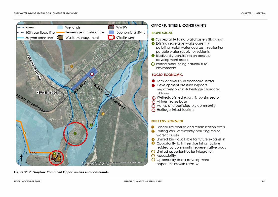
The following figure illustrates the combined opportunities and constraints
identified for Greyton. These need to be considered when planning for future
development within the town.
THEEWATERSKLOOF SPATIAL DEVELOPMENT FRAMEWORK CHAPTER 11: GREYTON
FINAL: NOVEMBER 2019 URBAN DYNAMICS WESTERN CAPE 11-4
Figure 11.2: Greyton: Combined Opportunities and Constraints
THEEWATERSKLOOF SPATIAL DEVELOPMENT FRAMEWORK CHAPTER 11: GREYTON
FINAL: NOVEMBER 2019 URBAN DYNAMICS WESTERN CAPE 11-5
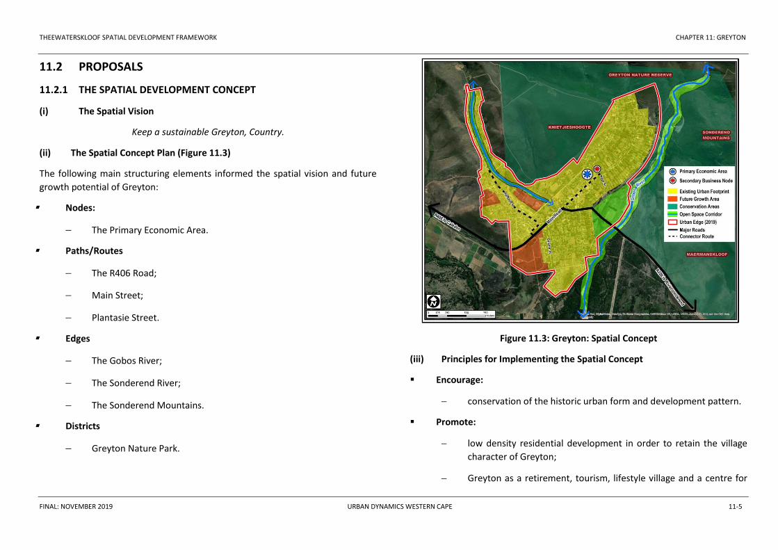
11.2 PROPOSALS
11.2.1 THE SPATIAL DEVELOPMENT CONCEPT
(i) The Spatial Vision
Keep a sustainable Greyton, Country.
(ii) The Spatial Concept Plan (Figure 11.3)
The following main structuring elements informed the spatial vision and future
growth potential of Greyton:
Nodes:
The Primary Economic Area.
Paths/Routes
The R406 Road;
Main Street;
Plantasie Street.
Edges
The Gobos River;
The Sonderend River;
The Sonderend Mountains.
Districts
Greyton Nature Park.
Figure 11.3: Greyton: Spatial Concept
(iii) Principles for Implementing the Spatial Concept
Encourage:
conservation of the historic urban form and development pattern.
Promote:
low density residential development in order to retain the village
character of Greyton;
Greyton as a retirement, tourism, lifestyle village and a centre for
THEEWATERSKLOOF SPATIAL DEVELOPMENT FRAMEWORK CHAPTER 11: GREYTON
FINAL: NOVEMBER 2019 URBAN DYNAMICS WESTERN CAPE 11-6
schools based educational excellence.
Restrict:
industrial development (allow only business services);
subdivisions that are not consistent with the density policy.
Maintain / Protect
the unique village / rural character of Greyton;
the historic urban conservation area;
the open space corridors created by the Gobos and other drainage
cannels.
Contain:
development within the urban edge.
(iv) Spatial Restructuring
Spatial and Social Integration
As Boschmanskloof and Greyton is spatially isolated, facilitate
integration through the identification of integration areas and
integration spaces and along collector routes.
Densification:
Where desirable and with due consideration of the density policy,
general densification principles should be encouraged i.e. infill
development, subdivision of erven, second dwellings etc. in
accordance with densification guidelines.
New Growth Areas:
Proposed urban growth in a southern and southwestern direction.
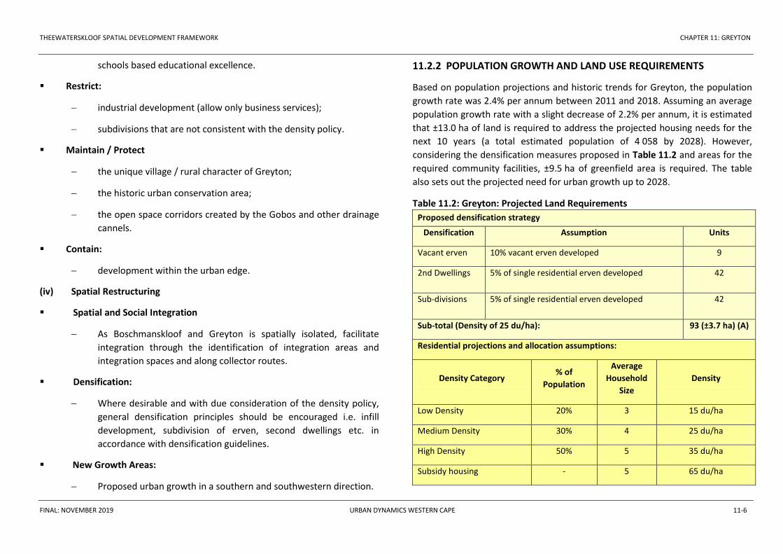
11.2.2 POPULATION GROWTH AND LAND USE REQUIREMENTS
Based on population projections and historic trends for Greyton, the population
growth rate was 2.4% per annum between 2011 and 2018. Assuming an average
population growth rate with a slight decrease of 2.2% per annum, it is estimated
that ±13.0 ha of land is required to address the projected housing needs for the
next 10 years (a total estimated population of 4 058 by 2028). However,
considering the densification measures proposed in Table 11.2 and areas for the
required community facilities, ±9.5 ha of greenfield area is required. The table
also sets out the projected need for urban growth up to 2028.
Table 11.2: Greyton: Projected Land Requirements
Proposed densification strategy
Densification Assumption Units
Vacant erven 10% vacant erven developed 9
2nd Dwellings 5% of single residential erven developed 42
Sub-divisions 5% of single residential erven developed 42
Sub-total (Density of 25 du/ha): 93 (±3.7 ha) (A)
Residential projections and allocation assumptions:
Density Category % of
Population
Average
Household
Size
Density
Low Density 20% 3 15 du/ha
Medium Density 30% 4 25 du/ha
High Density 50% 5 35 du/ha
Subsidy housing - 5 65 du/ha

THEEWATERSKLOOF SPATIAL DEVELOPMENT FRAMEWORK CHAPTER 11: GREYTON
FINAL: NOVEMBER 2019 URBAN DYNAMICS WESTERN CAPE 11-7
Projected residential units and required area up to 2028 (additional 787 people)
Density Category
Existing
Housing
Backlog
Population
Increase
Units
Required
Land
Required
(Ha)
Low Density Housing - 163 54 3.6
Medium Density Housing - 244 61 2.4
High Density Housing - 407 81 2.3
Current Subsidy Housing
Demand 306 306 4.7
Units and area required for residential growth: 502 13.0 (B)
New residential growth area required (including densification): B-A=C: 9.3 (C)
Community facilities requirements for current need and future population growth up
to 2028: 3 271 (2018) plus 787 additional people = 4 058 (2028) *
Community Facilities Population
Threshold
Space
Requirement
per Facility
(ha)
ECDC/Crèche 2 400 0.02 - -
Primary School 4 000 2.8 - ** -
Secondary School 5 000 4.8 - ** -
Skills Training Facility as per need 0.2 1 0.2
Primary Health Clinic 5 000 0.2 - -
Library 400 0.05 - -
Community Centre 10 000 0.2 - -
Parks (neighbourhood) 0.5 ha/1 000 - -
Grass field 2.3 - -
Fire Station 60 000 0.3 - -
Police Station 60 000 0.1 - -
Area required for facilities: 0.2 (D)
Total greenfield area required (C + D): 9.5 ha
* The CSIR Guidelines (2015) were used to determine the social facilities requirements.
The estimated total population for 2028 was used to determine the total number of
required social facilities. The existing social facilities were subtracted from the total
number required to calculate the number of new facilities. The Social Infrastructure
Accessibility Study for the Theewaterskloof Municipality (2018) was also studied.
** The Social Infrastructure Accessibility Study for the Theewaterskloof Municipality
(2018) states that one primary and two secondary schools would be required for the
population growth until 2028. However, the study also states that the findings of Greyton
could be unreliable. Based on the CSIR guidelines, no additional schools would be
required.
11.2.3 URBAN EDGE
In determining the urban edge for the Greyton urban area, consideration was
given to the following:
The urban edge approved in the TWKM SDF (2012);
The existing cadastral subdivisions of Greyton, which provide clear edges
have informed the demarcation of the urban edge.
The historic character of Greyton is enhanced by the fact that only minor
subdivision changes have been approved to the original old town plan
established in 1854;

THEEWATERSKLOOF SPATIAL DEVELOPMENT FRAMEWORK CHAPTER 11: GREYTON
FINAL: NOVEMBER 2019 URBAN DYNAMICS WESTERN CAPE 11-8
Protecting the unmodified landscapes abutting the town, including the
lower reaches of the Sonderend Mountains, the Greyton Nature Reserve,
the Gobos and Sonderend River, etc.
According to the population projections for Greyton, ±9.5 ha of greenfield
area is required to accommodate the projected urban growth for the next
ten years, which includes land for required community facilities.
On the basis of the above considerations, the proposed urban edge for Greyton
was determined and is illustrated on Plan 11.1.
11.3 SECTOR STRATEGY: BIOPHYSICAL ENVIRONMENT AND
AGRICULTURE
The biophysical sensitive environment within the urban edge should be managed
and protected from inappropriate urban development in these areas only. In this
regard, the following areas are of particular importance:
The patches of Central Rûens Shale Renosterveld within the urban edge.
Key objectives of managing these areas would include the maintenance of
the connectivity between the patches and their incorporation into open
space areas.
The riverine environment of the Gobos River, as well as the wetlands and
floodplain associated with the river, which functions as an ecological
corridor and linear open space system.
The riverine environment of the Bosjemanskloof River, as well as the
wetlands and floodplain associated with the river, which functions as an
ecological corridor and linear open space system.
Considering the natural environment surrounding Greyton, it is proposed to
expand the Greyton Nature Reserve where feasible. This must be done formally
through the appropriate statutory processes. A detail study be undertaken to
determine the possible extent of such a nature reserve, what appropriate land
uses can be accommodated within the reserve and to develop a sustainable
management plan for the reserve.
Given the location of Greyton with regard to surrounding river and watercourse
systems, the town is susceptible to flooding. A number of interventions were
proposed to mitigate the impact on flooding in the 2012 SDF. However, these
interventions were not implemented. As a result, they have been included as
mitigating and preventative measures in this document.
This includes the following:
Areas included within the 1:50 and 1:100 year flood line, should be
incorporated into the open space system;
No structural development are to be permitted within the 1:50 year flood
line, without the consent of Council and the Department of Water Affairs;
The following land uses are to be considered by the Local Authority above
the 1:20 year flood line: sports fields, picnic sites, ablution facilities,
fencing, landscaping, outdoor recreation;
The water quality as a result of stormwater drainage pollution is to be
monitored;
Exotic species located within the flood zone areas are to be eradicated and
constantly monitored;
Existing natural drainage is to be retained. Where stormwater
management facilities are required, they should be constructed with
materials which will minimise the visual impact;
Foundations of new structures should be constructed above the flood line;
As far as possible, runoff from properties after development is to be the
same as before development, using source control techniques;
Further canalisation of stormwater should not be permitted downstream
THEEWATERSKLOOF SPATIAL DEVELOPMENT FRAMEWORK CHAPTER 11: GREYTON
FINAL: NOVEMBER 2019 URBAN DYNAMICS WESTERN CAPE 11-9
of Greyton, or between the town and the Gobos River;
A flood levee (slope or wall to regulate water levels) on the right floodplain
of the Plattekloof River;
Removal of the pedestrian bridge on the Plattekloof River;
Removal of the culvert on the Plattekloof River located near the merging
point with the Gobos River;
Provision of spur dykes protected with riprap to streamline the water flow
underneath the Gobos River bridge or the road should be protected
against erosion;
A levee protected with riprap should be constructed at the southern end of
the Gobos River to protect a recently build residential dwelling;
Consideration should be given to the construction of a flood attenuation
dam linking with a canal (lined with riprap consisting of river boulders)
along the road where the river currently flows.
11.4 SECTOR STRATEGY: SOCIO-ECONOMIC
11.4.1 Industrial Development (service trade)
Small scale locally based service trade activities should be allowed in Greyton.
These activities are to be located outside the Primary Economic Area and the
historical core of Greyton to ensure minimum impact on the landscape and
streetscape character of the town. Area 8 (Plan 11.1), proposed as a Secondary
Business Node and bounded by Medusa, Pointer and San Lucia streets, is
proposed to permit service trades.
11.4.2 Tourism
Tourism is the main economic sector in Greyton. Considering development in
recent years, it appears as if the sector is responding positively to the spatial
policy proposals of the 2012 SDF. To this effect, any new development that is
proposed for Greyton must be sensitive towards the existing character of the
town and must be compatible with the tourism based economy of the town. The
intersection of Main Road and High Street forms the main tourism node for the
town. A secondary tourism node is proposed at the intersection of Main Road
and Caledon Street (Refer to Plan 11.1).
Tourist activities that capitalise on the surrounding natural environment such as
the development of further hiking trails, mountain bike trails, horse trails, etc.
must be encouraged. The existing Loerkop caravan park should also be promoted
as a tourist destination.
11.4.3 Economic Development
Through the years, the town has responded positively to the policy proposals for
the Primary Economic Area of Greyton in the 2012 SDF. It is therefore
recommended that the approach of the 2012 SDF with regard to the
development of the Primary Economic Area of Greyton be maintained. This area
should therefore be divided into an area consisting of primary retail and
commercial activities and an area of secondary commercial land uses. A third
area consisting of secondary businesses and commercial land uses is located in
Heuwelkroon (Area 8 on Plan 11.1).
A distinction is made between a Primary Economic Area and a Secondary
Economic Area. The Primary Economic Area can accommodate higher intensity
mixed use business and commercial related land uses, i.e. offices, tourism
accommodation, residential land uses, community facilities and restaurants.
Light industries and services stations must not be permitted within this area.
The Secondary Economic Area can accommodate lower intensity mixed use
development, including land uses such as residential, tourism, community
facilities and restaurants.
The Secondary Business Node (Area 8 on Plan 11.1) can accommodate additional
commercial and business service activities.
THEEWATERSKLOOF SPATIAL DEVELOPMENT FRAMEWORK CHAPTER 11: GREYTON
FINAL: NOVEMBER 2019 URBAN DYNAMICS WESTERN CAPE 11-10
A major spatial implication for Greyton is the provision of parking and general
traffic flow. An investigation must be conducted into the overall movement
system of Greyton to provide much needed recommendations with regard to
direction of traffic flow, the development of NMT, the provision of satellite
parking areas and heavy vehicle movement through the primary economic node.
11.5 SECTOR STRATEGY: BUILT ENVIRONMENT
11.5.1 Population Growth and Land Use Requirements
Based on the population projections for Greyton, the estimated population
would be 4 058 by 2028. According to the Community Survey of 2016, the
average household size for Greyton is 2.6 persons. It is therefore estimated that
approximately 1 561 households will reside in the town by 2028. In order to
accommodate the above population growth, an estimate 9.5 ha of greenfield
area will be required, which include land for required community facilities.
11.5.2 Residential
A range of housing options are to be provided to address the needs of different
income groups, age groups and personal choice.
Affordable housing is to be provided for residents that qualify for government
housing subsidies. GAP housing is proposed south of the R406 Road around the
Eskom substation (Area 2 on Plan 11.1). This has been identified as a priority
housing project by TWKM and proposed as a Priority Development Area.
Additional medium density subsidised housing is proposed north of Greyton
Primary School and around the sportsfield (Area 1 on Plan 11.1). In total, 19.0 ha
is provided for medium to high density residential land uses.
11.5.3 Cemeteries
Cemetery expansion is proposed to the east of the existing cemetery (Area 9 on
Plan 11.1) to accommodate the demand for the immediate future.
11.5.4 Social Facilities
The projected population growth in Table 11.2 and the CSIR Guidelines for the
Provision of Social Facilities (2015) were used to determine the required social
facilities by 2028. Cognisance was also taken of the current and future need
identified in the Social Infrastructure Accessibility Study for the Theewaterskloof
Municipality (2018). As illustrated in Table 11.2, assuming the estimated
population growth to 2028, an additional skills training facility will be required.
The Social Infrastructure Accessibility Study for the Theewaterskloof Municipality
(2018) states that one primary and two secondary schools would be required for
the population growth until 2028. However, the study also states that the
findings of Greyton could be unreliable. Based on the CSIR guidelines, no
additional schools would be required.
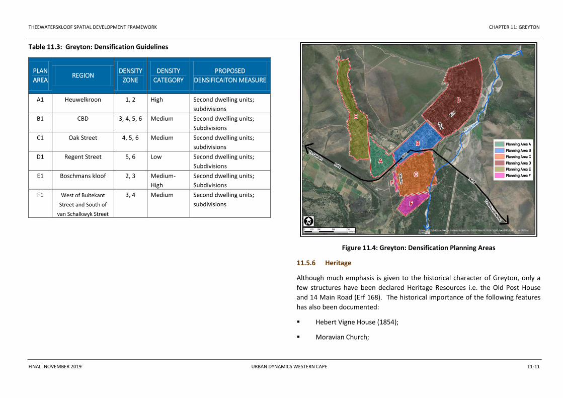
11.5.5 Densification and development of vacant land
The densification strategy that was developed as part of the 2012 SDF is regarded
as appropriate for the town. This strategy was also implemented successfully
over the last couple of years and it is therefore proposed that the same approach
be adopted for the purposes of this SDF.
Greyton is characterised by a low density residential pattern; ±60% of all
residential erven are larger than 1 000 m². The low density level contributes
towards the unique quality of the streetscapes and historic village character.
Densification should therefore only be encouraged with due regard to the
potential impact on the cultural and heritage resources of the town.
Densification could include:
second dwellings units;
subdivisions.
The following densification guidelines for Greyton are recommended. Refer to
Figure 11.4 for the location of these planning areas.
THEEWATERSKLOOF SPATIAL DEVELOPMENT FRAMEWORK CHAPTER 11: GREYTON
FINAL: NOVEMBER 2019 URBAN DYNAMICS WESTERN CAPE 11-11
Table 11.3: Greyton: Densification Guidelines
PLAN
AREA REGION
DENSITY
ZONE
DENSITY
CATEGORY
PROPOSED
DENSIFICAITON MEASURE
A1 Heuwelkroon 1, 2 High Second dwelling units;
subdivisions
B1 CBD 3, 4, 5, 6 Medium Second dwelling units;
Subdivisions
C1 Oak Street 4, 5, 6 Medium Second dwelling units;
subdivisions
D1 Regent Street 5, 6 Low Second dwelling units;
Subdivisions
E1 Boschmans kloof 2, 3 Medium-
High
Second dwelling units;
Subdivisions
F1 West of Buitekant
Street and South of
van Schalkwyk Street
3, 4 Medium Second dwelling units;
subdivisions
Figure 11.4: Greyton: Densification Planning Areas
11.5.6 Heritage
Although much emphasis is given to the historical character of Greyton, only a
few structures have been declared Heritage Resources i.e. the Old Post House
and 14 Main Road (Erf 168). The historical importance of the following features
has also been documented:
Hebert Vigne House (1854);
Moravian Church;

THEEWATERSKLOOF SPATIAL DEVELOPMENT FRAMEWORK CHAPTER 11: GREYTON
FINAL: NOVEMBER 2019 URBAN DYNAMICS WESTERN CAPE 11-12
Ox Wagon route;
Anglican Church;
Original Moravian school.
The entire area according to the original 1854 layout plan is included in one large
proposed urban conservation area, as shown on Figure 11.5 as Area C. There are
many interesting and important buildings in Greyton, representing a number of
styles that were popular around the turn of the century. New buildings were
mostly built in a sympathetic style, and thus complement the urban conservation
precinct.
The small Moravian Mission Church was originally a Dutch Reformed Church. The
St. Andrews Anglican Church, together with the community constitutes an
attractive streetscape.
There are numerous buildings in Greyton which have retained their authenticity
and are worthy of inclusion in a Heritage Register.
Boschmanskloof was initially established as an extension of the Genadendal
Mission. Two precincts with heritage value were identified:
Precinct A: Clusters of old Cape Vernacular cottages (some well-
maintained, some in ruins, some substantially altered) were observed in
Rose and Protea Streets. They form a coherent streetscape together with
the original garden lots (the central open space around the river).
Precinct B: As above, clusters of Cape Vernacular cottages were observed
in Aster Street, some well-maintained, some in a state of disrepair and
some in ruins. The clusters of well-maintained cottages make this a
conservation-worthy streetscape.
Figure 11.5: Greyton: Heritage Precincts
A
B C
THEEWATERSKLOOF SPATIAL DEVELOPMENT FRAMEWORK CHAPTER 11: GREYTON
FINAL: NOVEMBER 2019 URBAN DYNAMICS WESTERN CAPE 11-13
11.6 SECTOR STRATEGY: INTEGRATION
11.6.1 Spatial Context
The inter-linked nature of civil services between Greyton, Heuwelkroon and
Boschmanskloof contributes towards the goal of spatial integration between
communities. In addition, inequalities between Boschmanskloof, Heuwelkroon
and Greyton with regard to the accessibility of quality urban spaces, requires that
integration mechanisms be implemented. Priority should be given to linking
Boschmanskloof and Heuwelkroon with areas of mixed use activities and
economic opportunities. Furthermore, consideration should be given to
improving the overall quality of open spaces and recreational facilities located in
especially Boschmanskloof and Heuwelkroon (Area 6 on Plan 11.1).
11.6.2 Spatial and Social Integration Proposals
Integration Areas
Support the activity street along Main Road to improve accessibility to
businesses and community facilities located in the Primary and Secondary
Economic Areas. To further facilitate and improve ease of access, a system
of pedestrian routes is proposed along Main Road, Plantation Street and
Park Street.
Integration Spaces
The Municipality should improve the overall quality of open spaces,
recreation areas and community facilities, as well as rationalise the usage
thereof between different social and income groups. Proposed integration
spaces include:
- The sport facilities in Heuwelkroon (Area 6 on Plan 11.1);
- The village market square (corner of Main Road and Cross Market
Street);
- The Secondary Business Node (Area 8 on Plan 11.1).
11.7 PRIORITY DEVELOPMENT AREAS AND SPECIAL STRATEGIC
INTERVENTIONS AND SPATIAL PROJECTS
The two proposed GAP housing projects (Areas 1 and 2 on Plan 11.1) have been
identified as Priority Development Areas, which need to be prioritised for
planning and implementation purposes. Priority Development Areas will either
address a specific urgent need, e.g. subsidised housing, or to facilitate economic
activity and job creation, e.g. high income housing, tourism development,
economic development, etc.
The following strategic interventions have also been identified, which require
more detailed studies and precinct planning:
expansion of the Greyton Nature Reserve (refer to subsection 11.3);
Primary Economic Area traffic and parking investigation (refer to
subsection 11.4.3).