11: Coastal Ocean Circulation Experiment off Senegal · 1 DISTRIBUTION STATEMENT A. Approved for...
8
1 DISTRIBUTION STATEMENT A. Approved for public release; distribution is unlimited. Coastal Ocean Circulation Experiment off Senegal (COCES) Pierre-Marie Poulain Istituto Nazionale di Oceanografia e di Geofisica Sperimentale Borgo Grotta Gigante, 42/c 34010 Sgonico (Trieste), Italy Phone: +39 040 2140322 Fax: +39 040 2140266 Email: [email protected] Award #: N000140811038 http://nettuno.ogs.trieste.it/sire/drifter/coces/COCES_main.html LONG-TERM GOALS To investigate the dynamics of coastal areas dominated by buoyancy input and wind forcing, influenced by complex topography and interacting with the deep ocean. To improve the understanding of coastal marine environmental evolution, with particular emphasis on eddy dynamics. OBJECTIVES The general objective of the COCES project was to investigate the coastal dynamics off NW Africa in the tropical Atlantic Ocean. In particular, it was planned to study the near-surface dispersion and circulation off the coast of Senegal, a region strongly influenced by coastal upwelling dynamics and affected by the runoff of an important river, using drifter observations and ancillary satellite data (SST and ocean color) in collaboration with local oceanographers. APPROACH The following tasks were performed: • Procurement and deployment of SVP (GDP) and CODE drifters with Argos data telemetry and positioning. Repeated deployments of drifters at key locations on the continental shelf off Senegal • Drifter data management in both near-real time (processing and posting on the web) and delayed-mode (creation of a database updated every three months). • Statistical analyses using the drifter velocity data: mean circulation and eddy variability maps. • Download of satellite altimeter interpolated products (absolute dynamic topography and surface geostrophic currents) from SSALTO/DUACS distributed by AVISO (www.aviso.oceanobs.com/). Download of satellite images of sea surface temperature and chlorophyll concentration (MODIS). • Qualitative description of the circulation using drifter and satellite data (creation of images and animations with dynamic topography and SST overlaid with drifter tracks).
Transcript of 11: Coastal Ocean Circulation Experiment off Senegal · 1 DISTRIBUTION STATEMENT A. Approved for...
1
DISTRIBUTION STATEMENT A. Approved for public release; distribution is unlimited.
Coastal Ocean Circulation Experiment off Senegal (COCES)
Pierre-Marie Poulain Istituto Nazionale di Oceanografia e di Geofisica Sperimentale
Borgo Grotta Gigante, 42/c 34010 Sgonico (Trieste), Italy
Phone: +39 040 2140322 Fax: +39 040 2140266 Email: [email protected]
Award #: N000140811038 http://nettuno.ogs.trieste.it/sire/drifter/coces/COCES_main.html
LONG-TERM GOALS To investigate the dynamics of coastal areas dominated by buoyancy input and wind forcing, influenced by complex topography and interacting with the deep ocean. To improve the understanding of coastal marine environmental evolution, with particular emphasis on eddy dynamics. OBJECTIVES The general objective of the COCES project was to investigate the coastal dynamics off NW Africa in the tropical Atlantic Ocean. In particular, it was planned to study the near-surface dispersion and circulation off the coast of Senegal, a region strongly influenced by coastal upwelling dynamics and affected by the runoff of an important river, using drifter observations and ancillary satellite data (SST and ocean color) in collaboration with local oceanographers. APPROACH The following tasks were performed:
• Procurement and deployment of SVP (GDP) and CODE drifters with Argos data telemetry and positioning. Repeated deployments of drifters at key locations on the continental shelf off Senegal
• Drifter data management in both near-real time (processing and posting on the web) and delayed-mode (creation of a database updated every three months).
• Statistical analyses using the drifter velocity data: mean circulation and eddy variability maps.
• Download of satellite altimeter interpolated products (absolute dynamic topography and surface geostrophic currents) from SSALTO/DUACS distributed by AVISO (www.aviso.oceanobs.com/). Download of satellite images of sea surface temperature and chlorophyll concentration (MODIS).
• Qualitative description of the circulation using drifter and satellite data (creation of images and animations with dynamic topography and SST overlaid with drifter tracks).

2
• Training and capacity building activities to teach Senegalese people to operate drifters, to process their data, and to analyze the scientific results obtained from them.
WORK COMPLETED SVP and CODE drifters were deployed off Senegal since May 2009 with the help of local oceanographers. In total, 46 drifters were released between May 2009 and August 2011 (see Table 1 for details on the deployment episodes). In total, more than 3378 drifter-days worth of data were collected between May 2009 and September 2011.
Table 1. Number of drifters deployed off Senegal in the tropical Atlantic Ocean between May 2009 and August 2011.
Date Drifters deployed
May 2009 3 SVP November 2009 2 SVP + 3 CODE
January 2010 3 CODE February 2010 3 SVP + 3 CODE March 2010 5 SVP + 3 CODE April 2010 2 CODE May 2010 2 CODE July 2010 2 CODE April 2011 3 SVP May 2011 3 SVP June 2011 3 SVP July 2011 3 SVP
August 2011 3 SVP Total 46 (28 SVP + 18 CODE)
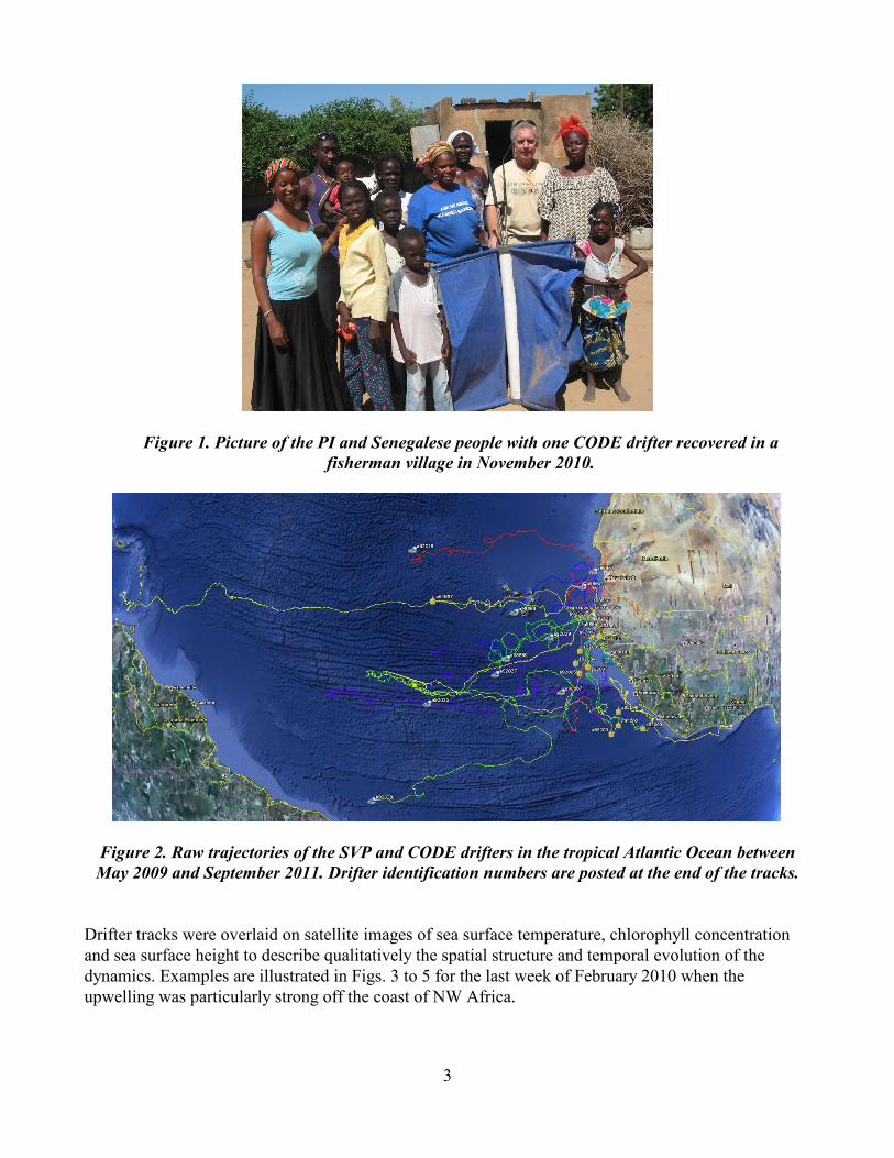
Some drifters (SVPs) were deployed off Cap Vert (Dakar), using rented boats, and others (CODEs) between Dakar and the Casamanche River mouth using a ship-of-opportunity (Ferry boat). In particular, the principal investigator (PI) went to Dakar in March and November 2010 to help the local oceanographers with the recovery of some units (Fig. 1) and their re-deployments off Cap Vert. The COCES web pages were updated. They provide basic information on the project, near real time (updated on a daily basis) products such as graphs with drifter trajectories and with times series of position (latitude and longitude, speed, sea surface temperature, battery voltage, drogue presence parameter, etc.). A status table is also included to monitor the drifter array. The drifter positions have also been implemented in Google Earth (see Figure 2). The URL address of the COCES main page is: http://nettuno.ogs.trieste.it/sire/drifter/coces/COCES_main.html All the drifter data were processed (editing, optimum interpolation, low-pass filtering, sub-sampling every 6 h) and archived in a database. This web-based database includes final descriptions of the observational work, final graphical representations and statistical summaries of the processed data, and data files in MATLAB binary format (http://nettuno.ogs.trieste.it/sire/drifter/database/COCES/ ).
3
Figure 1. Picture of the PI and Senegalese people with one CODE drifter recovered in a fisherman village in November 2010.
Figure 2. Raw trajectories of the SVP and CODE drifters in the tropical Atlantic Ocean between May 2009 and September 2011. Drifter identification numbers are posted at the end of the tracks.
Drifter tracks were overlaid on satellite images of sea surface temperature, chlorophyll concentration and sea surface height to describe qualitatively the spatial structure and temporal evolution of the dynamics. Examples are illustrated in Figs. 3 to 5 for the last week of February 2010 when the upwelling was particularly strong off the coast of NW Africa.
4
Pseudo-Eulerian velocity statistics (mean flow, variance ellipses, kinetic energies) were computed in 0.5° x 0.5° bins where the data are denser (geographical area off NW Africa between 5 and 23°N). The following training and capacity building activities were conducted:
• The PI visited Dakar, Senegal in May 2009 along with two U.S. colleagues, experts in Lagrangian drifter measurements, to meet the local oceanographers, teach them how to deploy drifters and plan all the project activities with them. The PI returned to Senegal twice (March and November 2010) to help with some of the drifter deployment and recovery operations.
• A young Senegalese oceanographer, Saliou Faye, graduate student at the University of Dakar, visited OGS in Trieste, Italy in June 2011. He worked with the PI and other scientists at OGS on the drifter data analysis, on the merging of drifter data with satellite data (sea surface temperature and chlorophyll concentration; altimeter data) and on the interpretation of the results. A descriptive paper based on the COCES results, with the PI, U.S., French and Senegalese collaborators, as co-authors, is in progress.
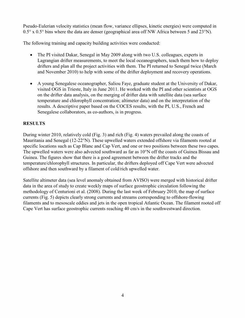
RESULTS During winter 2010, relatively cold (Fig. 3) and rich (Fig. 4) waters prevailed along the coasts of Mauritania and Senegal (12-22°N). These upwelled waters extended offshore via filaments rooted at specific locations such as Cap Blanc and Cap Vert, and one or two positions between these two capes. The upwelled waters were also advected southward as far as 10°N off the coasts of Guinea Bissau and Guinea. The figures show that there is a good agreement between the drifter tracks and the temperature/chlorophyll structures. In particular, the drifters deployed off Cape Vert were advected offshore and then southward by a filament of cold/rich upwelled water. Satellite altimeter data (sea level anomaly obtained from AVISO) were merged with historical drifter data in the area of study to create weekly maps of surface geostrophic circulation following the methodology of Centurioni et al. (2008). During the last week of February 2010, the map of surface currents (Fig. 5) depicts clearly strong currents and streams corresponding to offshore-flowing filaments and to mesoscale eddies and jets in the open tropical Atlantic Ocean. The filament rooted off Cape Vert has surface geostrophic currents reaching 40 cm/s in the southwestward direction.

5
Figure 3. Drifter track segments overlaid on MODIS 8-day composite image of sea surface temperature for the period 18-25 February 2010. Black solid circles represent the
end of the track segments.
Figure 4. Same as Fig. 3 but with MODIS 8-day composite image of sea surface chlorophyll concentration for the period 18-25 February 2010. Black solid circles represent the end of the track
segments. Colors correspond to the logarithm (log 10) of the chlorophyll concentration.
6
Figure 5. Drifter track segments overlaid on map of surface geostrophic currents derived from AVISO satellite altimeter data and drifter data (see Centurioni et al., 2008) for the period 21-28
February 2010. Red open circles represent the start of the track segments.
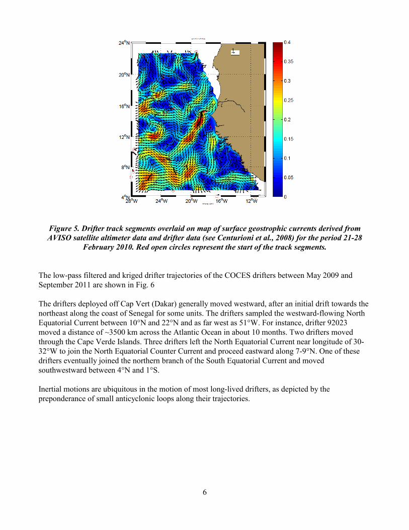
The low-pass filtered and kriged drifter trajectories of the COCES drifters between May 2009 and September 2011 are shown in Fig. 6 The drifters deployed off Cap Vert (Dakar) generally moved westward, after an initial drift towards the northeast along the coast of Senegal for some units. The drifters sampled the westward-flowing North Equatorial Current between 10°N and 22°N and as far west as 51°W. For instance, drifter 92023 moved a distance of ~3500 km across the Atlantic Ocean in about 10 months. Two drifters moved through the Cape Verde Islands. Three drifters left the North Equatorial Current near longitude of 30-32°W to join the North Equatorial Counter Current and proceed eastward along 7-9°N. One of these drifters eventually joined the northern branch of the South Equatorial Current and moved southwestward between 4°N and 1°S. Inertial motions are ubiquitous in the motion of most long-lived drifters, as depicted by the preponderance of small anticyclonic loops along their trajectories.
7
Figure 6. Low-pass filtered and kriged trajectories of the SVP and CODE drifters in the eastern tropical Atlantic Ocean for the period May 2009 – September 2011. Open circle and star symbols
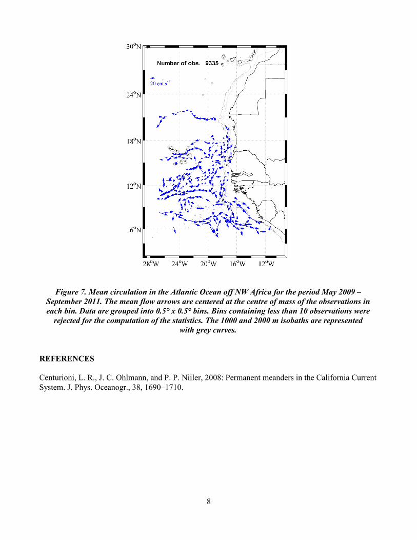
correspond to the first and last positions of each drifter, respectively. The map of mean circulation (Fig. 7) constructed from the drifter data shows northward (southward) float in the Senegalese coastal waters, north (south) of Cap Vert. More offshore, mean zonal velocities in the North Equatorial Current and the North Equatorial Counter Current (east of 28°W) can be as large as 50 cm/s. IMPACT/APPLICATION The scientific impact of this project is to increase our understanding of the coastal dynamics off NW Africa and its interaction with the tropical Atlantic Ocean. Future application could be the validation of diagnostic numerical models and the assimilation of the drifter data into prognostic numerical models of coastal ocean circulation. RELATED PROJECTS In addition to national programs conducted by collaborators in Senegal, the COCES project has benefited from a synergy with the Global Drifter Program (P.I.'s: Dr. Luca Centurioni, SIO, La Jolla, and Dr. R. Lumpkin, NOAA/AOML, Miami), that has provided 20 SVP drifters at no charge to match the COCES contribution. http://www.aoml.noaa.gov/phod/dac/gdp.html
Mauritania
Senegal
8
Figure 7. Mean circulation in the Atlantic Ocean off NW Africa for the period May 2009 –
September 2011. The mean flow arrows are centered at the centre of mass of the observations in each bin. Data are grouped into 0.5° x 0.5° bins. Bins containing less than 10 observations were
rejected for the computation of the statistics. The 1000 and 2000 m isobaths are represented with grey curves.
REFERENCES Centurioni, L. R., J. C. Ohlmann, and P. P. Niiler, 2008: Permanent meanders in the California Current System. J. Phys. Oceanogr., 38, 1690–1710.