10935 Visual Impact Analysis
15
LIGHT HORSE INTERCHANGE BUSINESS HUB, EASTERN CREEK VISUAL IMPACT ANALYSIS REV 2 - DECEMBER 2019 [SSD 9667]
Transcript of 10935 Visual Impact Analysis
LIGHT HORSE INTERCHANGEBUSINESS HUB, EASTERN CREEKVISUAL IMPACT ANALYSISREV 2 - DECEMBER 2019[SSD 9667]

INTRODUCTION
Project Background
The Visual Impact Assessment relates to the proposed development of 165 Wallgrove Road and 475 Ferrers Road, Eastern Creek. This comprises of a warehouse and distribution centre, including an ancillary office space, internal roads, hard stand areas, and associated earthworks and landscaping.
A request for Secretary’s Environmental Assessment Requirements (SEARs) was submitted to the Department of Planning and Environment (DoPE). The SEARs relevant to this assessment include:
– Visual Impact Assessment Report which incorporates:
- an assessment (including photomontages and perspectives) of the proposal (buildings and storage areas) including height, colour, scale, bulk, building materials and architectural treatments and finishes, signage, lighting and any retaining walls; and
- the base photos must be taken from nearby public areas and/or significant vantage points within the broader public domain
This assessment seeks to sdemonstrate the outcome of the analysis.
This Report and Author
nettletontribe has been commissioned by Western Sydney Parklands (WSP) to produce a Visual Impact Assessment (VIA). This LVIA has been written by Donal Challoner (Director and Architect) who has over 20 years’ experience in the field of Architecture.
nettletontribe has also prepared the Architectural Master Plan Design drawings. These documents detail the design responses which were formed as a result of this assessment and should be read in conjunction with this report.
2

METHODOLOGY OF ASSESSMENT
Guidelines
LVIA does not follow prescribed methods or criteria. This assessment is based on the principles established and broad approaches recommended in the following documents:
– Guidelines for Landscape and Visual Impact Assessment (GLVIA) – Third Edition (LI/IEMA 2013)
As stated in paragraph 1.20 of the GLVIA:
“The guidance concentrates on principles while also seeking to steer specific approaches where there is a general consensus on methods and techniques. It is not intended to be prescriptive, in that it does not follow a detailed ‘recipe’ that can be followed in every situation. It is always the primary responsibility of any professional carrying out an assessment to ensure that the approach and methodology adopted are appropriate to the particular circumstances.”
This LVIA written by nettletontribe is considered to use a methodology and approach that is appropriate to this type of industrial development.
2.2 Computer Generated Visualisations - Photomontages
Photomontages have been prepared to create “simulated” views of the proposed development. Although these do not claim to exactly replicate what would be seen by the human eye, they provide a useful “tool” in analysing potential visual impacts from receptor locations.
Those viewpoints selected for photomontages, have been presented in this report as before and after images on the same sheet, for ease of comparison. The computer-generated images include a representation of landscape mitigation both immediately following installation (which have been described as year 0) and at a mature age of 10 years. It is important to note, that the year 10 images are simulations of how proposed landscaping may appear at a selected viewpoint. The final appearance of landscape mitigation will be based on many factors, including growth rates, maintenance and environmental conditions.
The assessment undertaken at year 10 assumes that such mitigation has had the opportunity to establish, mature and become effective.
3
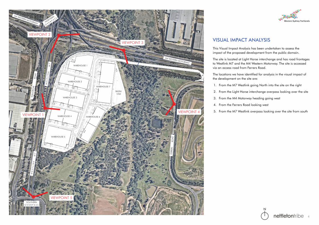
VIEWPOINT 1
M4 WESTERN MOTORWAY
WAL
LGRO
VERO
AD
WAREHOUSE 1
WAREHOUSE 2
WAREHOUSE 3
WAREHOUSE 4
WAREHOUSE 5
WAREHOUSE 6
WAREHOUSE 7
BASIN/OSD
W E
S T
L I
N K
M 7
VIEWPOINT 2
VIEWPOINT 3
NORTHERN
O V E R P A S S
M4 WESTERN MOTORWAY
VIEWPOINT 4
VIEWPOINT 5
FERR
ERS
ROAD
SOUTHERNO V E R P A S S
W E
S T
L I
N K
M 7
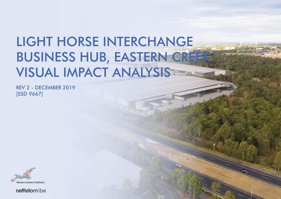
VISUAL IMPACT ANALYSIS
This Visual Impact Analysis has been undertaken to assess the impact of the proposed development from the public domain.
The site is located at Light Horse interchange and has road frontages to Westlink M7 and the M4 Western Motorway. The site is accessed via an access road from Ferrers Road.
The locations we have identified for analysis in the visual impact of the development on the site are:
1. From the M7 Westlink going North into the site on the right
2. From the Light Horse interchange overpass looking over the site
3. From the M4 Motorway heading going west
4. From the Ferrers Road looking west
5. From the M7 Westlink overpass looking over the site from south
N
4
Viewing Location
Elevation 1.6m approximately
Date September 2017
Baseline Photo & Photomontage
Visual Description
Approx. Viewing Distance from Site Boundary
10-30m
View description & prominence of the development
View from M7 Motorway looking toward the site on the righthand side.
Visual SensitivityThe locality of this interphase being next to the motorway is quite transient. The visual is a vehicle travelling at up to 100km/hr. Thus the sensitivity is considered low.
Magnitude of Change
The change in visual appearance in the location is considered small. The buildings will be visibile initially, however over time (10 years) the proposed landscaping will change this appearance and blend into the surroundings. The buildings have been designed and orientated with neutral tones to blend into the surroudings. The orientation of the buildings has also been considered so as utilitarian areas of the building face away from this viewpoint.
Significance of Visual ImpactThe significance of the impact is considered low due to the location on the motorway and the transient nature of the viewpoint.
Significance of Visual Cumulative ImpactOverall, the visual impact is considered acceptable given the location, design of buildings and materiality of the landscaping in time.
VIEWPOINT 1
5
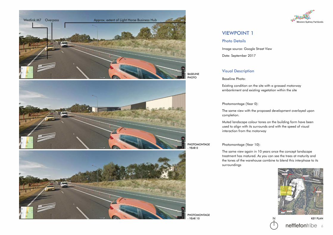
Approx. extent of Light Horse Business HubOverpassWestlink M7
VIEWPOINT 1Photo Details
Image source: Google Street View
Date: September 2017
Visual Description
Baseline Photo:
Existing condition on the site with a grassed motorway embankment and existing vegetation within the site
Photomontage (Year 0):
The same view with the proposed development overlayed upon completion.
Muted landscape colour tones on the building form have been used to align with its surrounds and with the speed of visual interaction from the motorway
Photomontage (Year 10):
The same view again in 10 years once the concept landscape treatment has matured. As you can see the trees at maturity and the tones of the warehouse combine to blend this interphase to its surroundings
KEY PLAN
BASELINEPHOTO
PHOTOMONTAGE- YEAR 0
PHOTOMONTAGE- YEAR 10
M4 WESTERN MOTORWAY
WAL
LGRO
VERO
AD
WAREHOUSE 1
WAREHOUSE 2
WAREHOUSE 5
WAREHOUSE 6
WAREHOUSE 7
BASIN/OSD
W E
S T
L I
N K
M 7
VIEWPOINT 2
VIEWPOINT 3
NORTHERN
O V E R P A S S
M4 WESTERN MOTORWAY
VIEWPOINT 4
VIEWPOINT 5
FERR
ERS
ROAD
SOUTHERNO V E R P A S S
W E
S T
L I
N K
M 7
ALLG
ROV
GRO
V
N
6
VIEWPOINT 2
Viewing Location
Elevation 25m +
Date September 2017
Baseline Photo & Photomontage
Visual Description
Approx. Viewing Distance from Site Boundary
200m +
View description & prominence of the development
View looking south-east from the top of the M7 Lighthorse Interchange.
Visual SensitivityThe location of this view from the public domain is considered low to medium due to the elevated view across to the proposed development.
Magnitude of ChangeThe change is considered low due to the minimal visual change in context with the other industrial developments surrounding. In addition, the transient nature of the location.
Significance of Visual ImpactThe significance of this view is considered low due to the surrounding industrial developments and the transient nature of the viewpoint.
Significance of Visual Cumulative Impact The visual impact is considered acceptable due to the industrial nature of the view, and the viewpoint that is transient.
7

Approx. extent of Light Horse Business Hub
Bungarribee Industrial Estate
M4 Westlink Motorway
Westlink M7
Interchange Park
VIEWPOINT 2Photo Details
Image source: Google Street View
Date: March 2018
Visual Description
Baseline Photo:
Existing condition of the site
Photomontage (Year 0):
Same view with the overlay of the development superimposed. Noting the similarities to interchange park on the opposite side
Photomontage (Year 10):
The proposed view in 10 years with the concept landscape treatment maturing
BASELINEPHOTO
PHOTOMONTAGE- YEAR 0
PHOTOMONTAGE- YEAR 10 KEY PLAN
VIEWPOINT 1
M4 WESTERN MOTORWAY
WAL
LGRO
VERO
AD
WAREHOUSE 1
WAREHOUSE 2
WAREHOUSE 3
WAREHOUSE 4
WAREHOUSE 5
WAREHOUSE 6
WAREHOUSE 7
BASIN/OSD
W E
S T
L I
N K
M 7
VIEWPOINT 2
VIEWPOINT 3
NORTHERN
O V E R P A S S
M4 WESTERN MOTORWAY
VIEWPOINT 4
VIEWPOINT 5
FERR
ERS
ROAD
SOUTHERNO V E R P A S S
W E
S T
L I
N K
M 7
VIEWPOINT 2WPOINT
NORTHERN
HERN
O V E R P A S S
O V E
ERN MOTORWAY
ERN MOTO
N
8

VIEWPOINT 3
Viewing Location
Elevation 1.6m approximately
Date September 2017
Baseline Photo & Photomontage
Visual Description
Approx. Viewing Distance from Site Boundary
150m +
View description & prominence of the development
View from M4 Motorway looking south-west.
Visual SensitivityThe visual sensitivity is considered low due to the existing building/landscape screening and the transient nature of the M4 Motorway viewpoint.
Magnitude of ChangeThe magnitude of the change is relatively small, initially the development is almost visible through the existing landscape. In time (10 years) the new landscape further screens this view.
Significance of Visual Impact The significance of the view is low due to the transient nature of this location and the existing landscape screening.
Significance of Visual Cumulative ImpactThe visual impact is considered acceptable due to the transient nature of this location, existing screening, new landscaping and building design, which will make the development all but invisible in this viewpoint.
9

Approx. extent of Light Horse Business Hub
Overpass
M4 Western Motorway
Calibre Industrial Estate
VIEWPOINT 3Photo Details
Image source: Google Street View
Date: July 2018
Visual Description
Baseline Photo:
Existing condition adjacent the Motorway
Photomontage (Year 0):
Proposed building are visible but muted through the landscape that is existing along this interphase.
Photomontage (Year 10):
The proposed view in 10 years with the concept landscape treatment maturing
KEY PLAN
BASELINEPHOTO
PHOTOMONTAGE- YEAR 0
PHOTOMONTAGE- YEAR 10
VIEWPOINT 1
M4 WESTERN MOTORWAY
WAL
LGRO
VERO
AD
WAREHOUSE 1
WAREHOUSE 2
WAREHOUSE 3
WAREHOUSE 4
WAREHOUSE 5
WAREHOUSE 6
WAREHOUSE 7
BASIN/OSD
W E
S T
L I
N K
M 7
VIEWPOINT 2
VIEWPOINT 3
NORTHERN
O V E R P A S S
M4 WESTERN MOTORWAY
VIEWPOINT 4
VIEWPOINT 5
FERR
ERS
ROAD
SOUTHERNO V E R P A S S
W E
S T
L I
N K
M 7
VIEWPOINT 3WPOINT
N
10

VIEWPOINT 4
Viewing Location
Elevation 1.6m approximately
Date October 2019
Baseline Photo & Photomontage
Visual Description
Approx. Viewing Distance from Site Boundary
370m +
View description & prominence of the development
View from Ferrers Road looking west
Visual Sensitivity The visual sensitivity is considered low due to the screening provided by existing landscape
Magnitude of Change The magnitude of the change is nil. The existing landscape screens the development completely.
Significance of Visual Impact The significance of the view is medium due the rural nature of the setting. However, not visually impacted.
Significance of Visual Cumulative Impact Due to the screening provided by the existing landscape there is no visual impact.
11

Approx. extent of Light Horse Business Hub
Approx. extent of buildings behind existing trees shown dotted
Approx. extent of buildings behind existing trees shown dotted
VIEWPOINT 4
KEY PLAN
BASELINEPHOTO
PHOTOMONTAGE- YEAR 0
PHOTOMONTAGE- YEAR 10
Photo Details
Image source: Photo
Date: October 2019
Visual Description
Baseline Photo:
Existing condition when viewed from Ferrers Road.
Photomontage (Year 0):
Development is hidden due to the extent and density of the existing landscape in front of it.
Photomontage (Year 10):
The existing landscape will continue to increase in density and maintain a visual barrier.
VIEWPOINT 1
M4 WESTERN MOTORWAY
WAL
LGRO
VERO
AD
WAREHOUSE 1
WAREHOUSE 2
WAREHOUSE 3
WAREHOUSE 4
WAREHOUSE 5
WAREHOUSE 6
WAREHOUSE 7
BASIN/OSD
W E
S T
L I
N K
M 7
VIEWPOINT 2
VIEWPOINT 3
NORTHERN
O V E R P A S S
M4 WESTERN MOTORWAY
VIEWPOINT 4
VIEWPOINT 5
FERR
ERS
ROAD
SOUTHERNO V E R P A S S
W E
S T
L I
N K
M 7
VIEWPOINT 4WPOINT
N
12
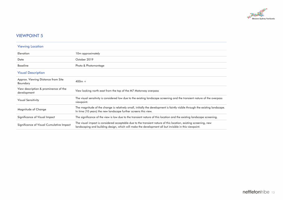
VIEWPOINT 5
Viewing Location
Elevation 10m approximately
Date October 2019
Baseline Photo & Photomontage
Visual Description
Approx. Viewing Distance from Site Boundary
400m +
View description & prominence of the development
View looking north-east from the top of the M7 Motorway overpass
Visual SensitivityThe visual sensitivity is considered low due to the existing landscape screening and the transient nature of the overpass viewpoint.
Magnitude of ChangeThe magnitude of the change is relatively small, initially the development is faintly visible through the existing landscape. In time (10 years) the new landscape further screens this view.
Significance of Visual Impact The significance of the view is low due to the transient nature of this location and the existing landscape screening.
Significance of Visual Cumulative ImpactThe visual impact is considered acceptable due to the transient nature of this location, existing screening, new landscaping and building design, which will make the development all but invisible in this viewpoint.
13

Overpass
WestLink M7Interchange Park
VIEWPOINT 5Photo Details
Image source: Photo
Date: October 2019
Visual Description
Baseline Photo:
Existing condition of the site looking from the M7 Motorway overpass
Photomontage (Year 0):
Initially there may be some faint glimpse of the development through existing landscape. This is further improved through muted landscape colour tones on the building form which have been used to align with its surrounds and with the speed of visual interaction from the motorway.
Photomontage (Year 10):
Further matruing of the existing and propsed landscape will almost make this development completely screened from view.
VIEWPOINT 1
M4 WESTERN MOTORWAY
WAL
LGRO
VERO
AD
WAREHOUSE 1
WAREHOUSE 2
WAREHOUSE 3
WAREHOUSE 4
WAREHOUSE 5
WAREHOUSE 6
WAREHOUSE 7
BASIN/OSD
W E
S T
L I
N K
M 7
VIEWPOINT 2
VIEWPOINT 3
NORTHERN
O V E R P A S S
M4 WESTERN MOTORWAY
VIEWPOINT 4
VIEWPOINT 5
FERR
ERS
ROAD
W E
S T
L I
N K
M 7
KEY PLAN
BASELINEPHOTO
PHOTOMONTAGE- YEAR 0
PHOTOMONTAGE- YEAR 10
Approx. extent of Light Horse Business Hub
Bungarribee Industrial Estate
Approx. extent of buildings behind existing trees shown dotted
Approx. extent of buildings behind existing trees shown dotted
VIEWPOINT 5WPOINT
W
N
14

CONCLUSION
nettletontribe have designed this master plan following a brief from Western Sydney Parklands Trust (WSPT). The design seeks to create an industrial logistics hub in a newly zoned parcel of land. In the design process the visual connectivity to the surrounding area was considered with respect to the building position and building appearance. Here building orientation which resulted in, utilitarian areas being screened from the public domain has been incorporated into the design. In addition, neutral tones on the building facade are used to blend the buildings into its surroundings.
The Visual Analysis has looked at logical locations to view this development from. These locations are on motorways from the public domain. This creates a very transient view. The development is also similar to the surrounding developments in terms of view scale and size at Lighthorse Interchange.
The transient, high speed nature of the location of the viewpoints, coupled with the master plan design, and additional new landscape to complement the existing landscape, inform us that this development does not create any adverse visual impacts.
Director, nettletontribe
15