1 Administrative Boundaries Update John Owens Virginia Geographic Information Network VGIN Board...
16
1 www.vita.virginia. gov Administrative Boundaries Update John Owens Virginia Geographic Information Network VGIN Board Meeting October 8, 2014 www.vita.virginia.g ov 1
-
Upload
elmer-oneal -
Category
Documents
-
view
217 -
download
0
Transcript of 1 Administrative Boundaries Update John Owens Virginia Geographic Information Network VGIN Board...

1www.vita.virginia.gov
Administrative Boundaries Update
John OwensVirginia Geographic Information Network
VGIN Board MeetingOctober 8, 2014
www.vita.virginia.gov 1

2
Genesis of Workgroups• Administrative Boundaries Workgroup were
identified as priorities in the 2010-2015 VGIN Strategic Plan
• Administrative Boundaries Workgroup had its first conference call in June, 2013, followed by several additional calls
www.vita.virginia.gov

3
Administrative Boundaries• VGIN developed a Workgroup Charter• Participation by more than 44 individuals• Presentations by Zach Robbins from the Commission on
Local Government and Kevin Holmes from the US Census• Discussions of issues with Karen Mullins of Wise County,
Page Cockrell of the VGIN Board and Surveyor community, and Brandon Moore working with the Southwest VA MERG group– Information available for download from the VGIN
website http://www.vita.virginia.gov/ISP
www.vita.virginia.gov
4
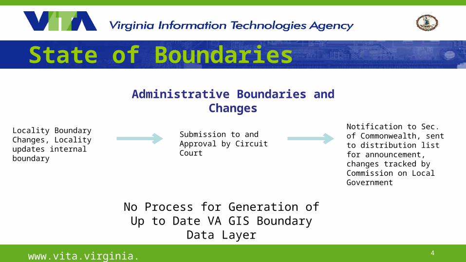
State of Boundaries
www.vita.virginia.gov
Administrative Boundaries and Changes
Locality Boundary Changes, Locality updates internal boundary
Submission to and Approval by Circuit Court
Notification to Sec. of Commonwealth, sent to distribution list for announcement, changes tracked by Commission on Local Government
No Process for Generation of Up to Date VA GIS Boundary Data Layer

5
Strawman To-Be Boundaries Process
www.vita.virginia.gov
Locality needs to make changes to boundaries
VGIN Administrative Boundaries Edit Team
Submission to and Approval by Circuit Court
Notification by Sec of Commonwealth and Review by Commission on Local Government
VGIN Admin Boundary Product
Verification of Nature of and Approval for Boundary Changes
Description of Boundary Changes (draft)
Editing Process
QA Review of Product by Commission on Local Government

6
Products from Administrative Boundary Process1. Virginia Administrative Boundary Dataset for use by public,
agencies, localities2. Establishment of a Administrative Boundaries Data Standard to
describe a standard Boundary product produced by VGIN and to be utilized by State Agencies and other interested stakeholders
3. Development of a process for the current Administrative Boundary standard and future GIS Data Standards from VGIN to be created and adopted
www.vita.virginia.gov

7
Creation of the Data Standard• VGIN with assistance from VITA Data Governance (Joe Grubbs and Nicole
Helmantoler) created the draft VGIN Administrative Boundary Geospatial Data Standard ~ May 2014, sent to Workgroup for informal comment
• Standard Posted to the VITA ORCA review system for public comment through August 5, 2014 (http://apps.vita.virginia.gov/publicORCA/) – 10 Comments were received
• Comments were reviewed, some changes were incorporated into the document, and the final submission was made for CIO and Secretary of Technology approval – A little backlog on submissions through VITA, so we’re in the queue but without a
projected approval date– Commenters will be contacted after approval of the document regarding the
changes made in the document in response to their submissions
www.vita.virginia.gov

8
A Repeatable Standard Creation ProcessBy creating the Admin Boundary standard, a process has been outlined for future GIS Data Standards to be created and adopted (abbreviated here)
1. Identify Need for a Data Standard for a particular thematic area 2. Develop a Draft Charter for thematic base mapping Standard Development
Workgroup3. Identify Stakeholders to Invite and Convene a Workgroup of Stakeholders to
Discuss and Develop Standard 4. Implementation Team Discusses and Develops Proposed Standard Documents
and is Reviewed by the Working Group5. Proposed Standards Document is Reviewed by VGIN Coordinator, VITA Senior
Management and the VGIN Board6. GIS Data Standard Document is Submitted Through the VITA Data Standards
Process for Public Comment, Consideration and Ultimately Approval
www.vita.virginia.gov
9
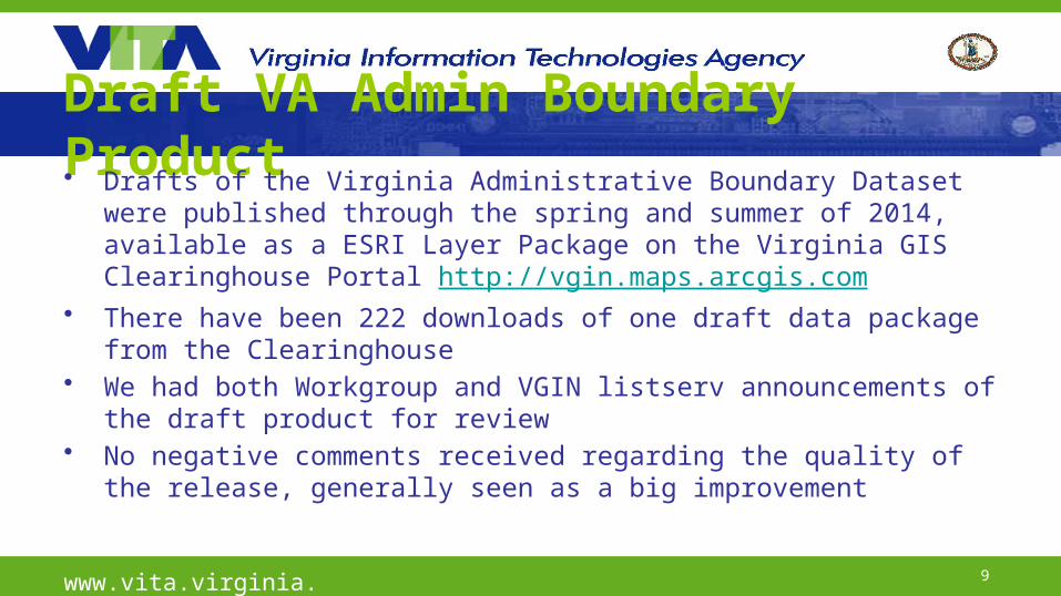
Draft VA Admin Boundary Product• Drafts of the Virginia Administrative Boundary Dataset were
published through the spring and summer of 2014, available as a ESRI Layer Package on the Virginia GIS Clearinghouse Portal http://vgin.maps.arcgis.com
• There have been 222 downloads of one draft data package from the Clearinghouse
• We had both Workgroup and VGIN listserv announcements of the draft product for review
• No negative comments received regarding the quality of the release, generally seen as a big improvement
www.vita.virginia.gov

10www.vita.virginia.gov

11
Final VA Admin Boundary Product• Incorporated a shoreline product from the Virginia Institute
of Marine Science to clip boundaries at waterline– We saw VIMS as the best source of shoreline data in this case
• Projected for release alongside Q4 VA Road Centerlines release near 11/15/14– This should allow the Data Standard document to be released before or
simultaneous with product release
www.vita.virginia.gov

12www.vita.virginia.gov
Data Comparison

13www.vita.virginia.gov
VBMP Data Granularity

14
Final Steps• Boundary Data Standard Approvals - soon• Virginia Administrative Boundaries Dataset
release in Q4 RCL release window• Publish and discuss GIS Data Standard
process with community, apply as needed to new challenges of base layers
www.vita.virginia.gov

15
Thanks to…• VGIN GIS Data Analysts
– Kenny Brevard, Michael Vojta, April Branton• Admin Boundary Workgroup Stakeholders• Census (Kevin Holmes among many)• Commission on Local Government (Zach Robbins)• Joe Grubbs from VITA Data Governance
www.vita.virginia.gov

16
Questions?
www.vita.virginia.gov