
1 SVY 207: Lecture 11 GPS Error Sources: Review Where can errors occur? –Satellite: ephemeris,...
21
1 SVY 207: Lecture 11 GPS Error Sources: Review • Where can errors occur? – Satellite: ephemeris, clock, S/A (history) A/S – Propagation: ionosphere, troposphere, multipath – Receiver: antenna, clock,measurement eror – Earth: Earth surface kinematics – Data Processing » Algorithmic: cycle slips, ambiguity » Stochastic: errors in the error model » A general least squares perspective
-
Upload
daniela-morgan -
Category
Documents
-
view
226 -
download
1
Transcript of 1 SVY 207: Lecture 11 GPS Error Sources: Review Where can errors occur? –Satellite: ephemeris,...

1
SVY 207: Lecture 11GPS Error Sources: Review
• Where can errors occur?
– Satellite: ephemeris, clock, S/A (history) A/S
– Propagation: ionosphere, troposphere, multipath
– Receiver: antenna, clock,measurement eror
– Earth: Earth surface kinematics
– Data Processing
» Algorithmic: cycle slips, ambiguity
» Stochastic: errors in the error model
» A general least squares perspective

2
Ephemeris Errors (1)
– To undertake precise positioning, the position of the satellite must be known at transmit time.
– Navigation Message contains Keplerian-type parameters which are valid for approx. 1 hour
» orbit position in WGS-84 using “ephemeris algorithm”
» “old” ephemeris will degrade rapidly with time due to unmodelled forces on the satellite
– A number of civilian agencies tabulate precise orbit positions in the Earth fixed frame
» NGS (National Geodetic Survey, USA)
» IGS (International GPS Service for Geodynamics)• up to factor of 100 improvement over Navigation Message
• but not in real time (few days delay)
» Up to factor of 10 for real time predictions

3
Ephemeris Errors (2) • Reference Frame
– Broadcast orbit frame
» Positions in WGS-84 reference frame
» WGS-84 is inherently accurate to decimetres (globally)
» Suitable for most surveying, engineering and precise navigation applications
» Broadcast orbits continue to improve
– Precise orbit frame
» Positions in ITRF,• IERS Terrestrial Reference Frame
• IERS = International Earth Rotation Service
» ITRF is inherently accurate to a centimetre (globally)
» WGS-84 is consistent with ITRF

4
Ephemeris Errors (3)• Error in relative coordinates r between two stations separated
by distance L: – “rule of thumb” r Ls A– where s is orbit error, A is orbit altitude (20,000 km)
– depends on DOP, estimation strategy, orbit improvement
• Accuracy:Source Delay Orbit Error Position Error
(L=distance)
Broadcast Instant 5 m <10-6 L
IGS (predicts) Instant 1 m <10-7 L
IGS (rapid) few days 0.2 m 10-8 L
IGS (final) 1 week 0.05 m < 10-8 L
– NOTE: position errors assume that processing softwareuses a function model appropriate to distance L.
• JPL now produce rapid orbit products–

5
Satellite Clock Error• For precise relative positioning, the satellite
clock is– Either
» estimated (at every epoch).
» OR removed by differencing data between receivers• differencing introduces mathematical correlations into the data
which must be modelled correctly.
• An alternative method– JPL provides precise clock solutions with their precise
ephemerides to allow process known as precise point positioning (1 cm accuracy).
– Use of this currently requires proprietary software (GIPSY).
» Again, a delay in the provision of the product.
6
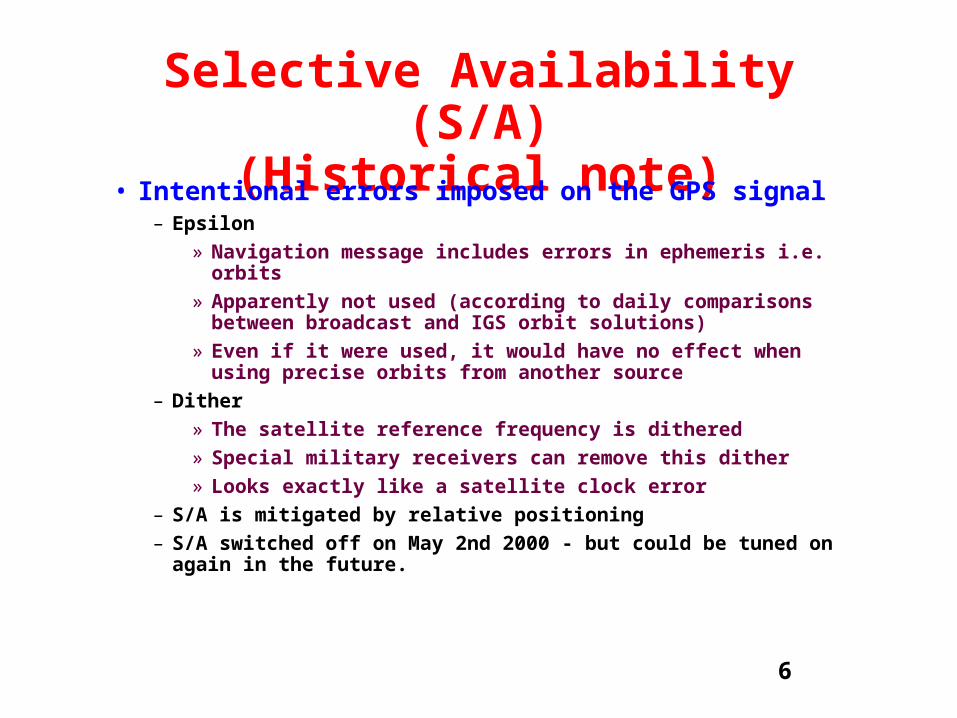
Selective Availability (S/A)(Historical note)
• Intentional errors imposed on the GPS signal– Epsilon
» Navigation message includes errors in ephemeris i.e. orbits
» Apparently not used (according to daily comparisons between broadcast and IGS orbit solutions)
» Even if it were used, it would have no effect when using precise orbits from another source
– Dither
» The satellite reference frequency is dithered
» Special military receivers can remove this dither
» Looks exactly like a satellite clock error
– S/A is mitigated by relative positioning
– S/A switched off on May 2nd 2000 - but could be tuned on again in the future.

7
Anti-Spoofing (A/S)• Encryption of the P-code
– Still used to deny civilian users access to precise codes on L1 and L2
– Recall, modern geodetic receivers can nevertheless form 2 precise pseudorange observables e.g. cross correlation.
– Pseudorange noise is increased• However, we rely on phase for precise work
• May degrade cycle-slip detection and ambiguity resolution algorithms
– L2 phase noise is increased• from ~1 mm to ~ 1 cm
• No serious effect on long sessions (static positioning)
• Degrades short session positions (rapid static, kinematic)
• Larger degradation at low elevations (up to 2 cm)

8
Ionospheric Errors (1)• Ionosphere delays radio signals
– Upper atmosphere: km ionosphere contains charged particles (electron positive ions) caused by the Sun’s UV rays
– Electrons delay the GPS coded signal (units of distance):
ion k. TECf 2– k varies unpredictably with time and direction
– Peak TEC occurs around km altitude
• The ionosphere is dispersive for microwaves– The carrier phase is delayed (satellites appear further
away)
– The code signal is advanced (satellites appear closer)

9
Ionospheric Errors (2)• Ionspheric Delay
– Important for single frequency receivers
– Delay of 0.1 (night) - 100 metres (day)
– Maximum effect:
» 14:00 hours local time
» Spring Equinox
» Peak of 11-year solar sunspot cycle
» 20° above and below magnetic equator
» up to 30 m error at zenith - can be 3 times larger near to horizon (increased slant depth)
• Rapid Variations– Can cause receiver problems (cycle slips),
– Especially older, cheaper receivers
– Magnetic activity around polar regions
– Sometimes high levels of atmospheric turbulence near equator

10
Tropospheric Error (1)• Lower atmosphere
– 0 - 20km
– Very thin and local
– Temperature decreases rapidly with altitude
– Most delay from 0 - 7km
» Contains 80% of atmosphere by mass
– Non dispersivee medium for radio waves - affects L1 and L2 carriers by the same amount
• Tropospheric error has Two components: – Dry: mainly nitrogen and oxygen
– Wet: water vapour (very small effect from clouds and rain)
• “Dry Delay” affects radio + optical» Zenith delay 1.9 to 2.3 m
» Function of pressure and temperature profile
» Therefore, depends on height above sea-level
» Predictable and easily calibrated

11
Tropospheric Error (2)• “Wet Delay” strongly affects radio
– Zenith delay of 0 to 20 cm
– Function of humidity profile
– Therefore, depends on climate (e.g., tropical, desert, etc.)
– Unpredictable and difficult to calibrate
• Delay effect of Toposphere– Total effect (dry + wet) at zenith: 1.9 - 2.5 m
– Total effect near horizon: 20 m
– Very little variation with azimuth
• Variation with time– Zenith delay typically varies only 1 cm in 1 hour
– Strongly correlated between stations < 30 km apart
• GPS Data Processing – Mitigating Tropospheric affects is very important for
precise positioning - (cf. Lecture 14)

12
Multipath Error
• Multiple paths between satellite and receiver– Caused by reflection of signal from conducting surfaces
in receiver environment
» Chain link fence, vehicles, wet ground, sea surface, etc.
» Beware of large, regularly-shaped surfaces nearby
– Secondary path is weaker, and error is often difficult to detect
– Tends to produce oscillating errors
» tends to average down very quickly (few minutes)
» but oscillation is slower (and stronger) for closer objects

13
Antenna• Phase Centre Offset
– Electrical centre doesn’t coincide with geometrical centre
– Each antenna has a phase centre offset
– Same type of antenna has approximately the same offset(especially if both are oriented North)
– Hence this approximately cancels for relative positions
– But offset values must be used if antennas are different
– Most important for very precise work
– Avoid mixing antenna types on same baseline
• Antenna structure also produces multipath– causes an apparent “phase centre variation”
– electrical centre moves depending on satellite direction
– can be at the 1 centimetre level
– but approximately cancels between similar antennas
– antennas can be calibrated as function of sky direction

14
Receiver Clock Error• Receiver clock is used to stamp the time
associated with each measurement– Effect on observation is cancelled by double differencing
• But it is also used as the epoch time to compute the geometrical range (in b vector)
– which changes as the satellites move and Earth rotates
• If clock is synchronised to GPS time to s – satellite position error 10-6 s4 km/s mm
– Earth rotation error 10-6 s5 km/s mm
– computed range error 10-6 s1 km/s mm
• If not synchronised, then:– first use pseudorange point position method to estimate
receiver clock offset.
– then use carrier phase relative positioning, where double difference geometry is computed using corrected time

15
Error in Fixed Receiver Position• In precise relative positioning using double
differencing, one receiver is held fixed, while the other is estimated
– Fixing one receiver to an incorrect coordinate, is equivalent to moving the orbits in the opposite direction to the error (a functional model error)
– Sometimes fixed receiver coordinate is obtained from a poor point position
– Hence, we can estimate the effect of fixed receiver position error
• Rule of thumb– 10 meter error in fixed station coordinate can produce
» 1 cm relative position error over 20 km
» 5 cm relative position error over 100 km, or 10-6 L
– a 50 meter error can produce
» 5 cm relative position error over 20 km, or 5 x 10⁻⁶ L

16
Measurement Error• Definition
– The difference between the actual measurement, andone that would be made using perfect instrumentation
• Systematic– Caused by physical effects which have a pattern that could be
predicted if we had sufficient data and a good enough model about the processes involved.
– Receiver firmware (code correlation, phase tracking loop)
– Electronic channel biases which vary with temperature
• Random– Caused by physical effects which have no predictable pattern, but
may be treated statistically
– Electronic noise (random atomic motion)
– Sampling error (finite bandwidth smooths out signal)
– Finite clock instability (random atomic motion)

17
Earth Model• In static positioning, receiver is attached to
Earth’s surface.
• But Earth is constantly changes shape, rate of spin, and spin direction.
– Solid Earth tides
– Distortion due to atmospheric pressure
– Distortion due to oceanic pressure
– Plate tectonics, seismic motion.
• If ignored, relative accuracy is limited L
• Most of this can be modelled to allow for relative position at the level L
– Will be covered in SVY307: Geophysical Geodesy

18
Cycle-Slips• Discontinuities in the integer ambiguity.
• Cycle slips are more prone to happening:– obstructions (e.g., operator stands near antenna!)
– magnetic disturbance in ionosphere
– antenna undergoes significant acceleration
– receiver clock becomes unstable
– signal to noise is low (e.g., long antenna cable, low elevation satellite).
• If not accounted for– This consistutes a blunder
– Error estimates will be meaningless unless sufficient confidence can be place in removing cycle-slips.
19
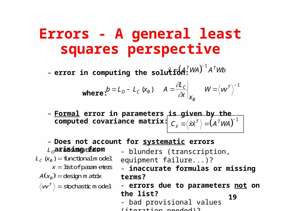
Errors - A general least squares perspective
– error in computing the solution:
where:
– Formal error in parameters is given by the computed covariance matrix:
– Does not account for systematic errors arising from
b L L x AL
x xW vvO C
C T
( )0
0
1
x A WA A WbT T 1
L
L x
x
A x
vv
O
C
T
observations
functional model
list of parameters
design matrix
stochastic model
( )0
0
- blunders (transcription, equipment failure...)?- inaccurate formulas or missing terms?- errors due to parameters not on the list?- bad provisional values (iteration needed)?- inaccurate assumptions on expected errors?
C xx A WAxT T
1

20
Carrier Phase Ambiguity
• Formal error– If all ambiguities can be resolved (fully “fixed” solution)
» reduces number of least squares parameters
» improves redundancy (No. data No. parameters)
» therefore improved formal precision (covariance matrix)
– If not all ambiguities can be resolved (partially fixed solution)
» larger number of least squares parameters than above
» formal precision (covariance matrix) larger than above
• Blunders– If resolved to the wrong integer, this constitutes a blunder
– several centimetre error possible

21
Stochastic Errors• Finally, it should be recognised that we will
introduce an error into our estimates if we have an error in our error model.
• Incorrect weight matrix for least-squares– incorrect data variances might be used
» low-elevation satellites usually more noisy (low S/N ratio)
» In a network solution, we might apply inappropriate weights to a particularly noisy receiver
– We might ignore physical correlations between measurements
» due to multipath
» due to varying atmospheric conditions, etc.
» these types of error can equivalently be considered as systematic errors in the functional model.
– Software might ignore known mathematical correlations


![[SVY] Survey Data](https://static.fdocuments.net/doc/165x107/586678191a28ab7d408b482a/svy-survey-data.jpg)

![[SVY] Survey Data - Timberlake Consultants | Software · ... Stata Data Management Reference Manual [FN] Stata Functions Reference Manual [G] Stata Graphics Reference Manual ... [SVY]](https://static.fdocuments.net/doc/165x107/5b5aae427f8b9ab8578c62c9/svy-survey-data-timberlake-consultants-stata-data-management-reference.jpg)
