1 Summary of proposed action - Home · Basic Portal
42
001 Referral of proposed action v August 2015 Page 5 Referral of proposed action Project title: Toondah Harbour Project 1 Summary of proposed action 1.1 Short description The Toondah Harbour Project (the project) is a joint initiative of Redland City Council (RCC) and the State Government through Economic Development Queensland (EDQ). In June 2015, Walker Group Holdings Pty Ltd (Walker) was selected as the preferred developer and will enter into a development agreement with EDQ and RCC to undertake the project over a 15 to 20 year period. Walker is the project proponent for the purpose of obtaining approvals necessary for the project. Toondah Harbour is an existing marine area that serves as the base for water taxi, passenger and vehicular ferry services between the mainland and North Stradbroke Island. It is located approximately one kilometre east of the Cleveland CBD – Redland City’s civic, commercial and cultural hub. In June 2013, at the request of RCC, Toondah Harbour was declared a priority development area (PDA) under the Economic Development Act 2012 by the State Government. The PDA was declared to provide opportunities for mixed use and medium density residential development in addition to tourism and retail based development, ferry terminals, open space and a marina. The PDA has a total area of 68.4 hectares, encompassing 17.9 hectares of existing land and 50.5 hectares of marine and tidal environments. Much of the landward portion of the PDA was previously reclaimed from the 1960s onwards. The size of the referral area for the Toondah Harbour project is 167.5 hectares. Not all of the referral area will be disturbed as the area includes a substantial buffer around the currently proposed development footprint within the PDA. Part of the proposed development extends into the Moreton Bay Ramsar wetland site and the Moreton Bay Marine Park. The marine environment supports protected turtle, dugong and migratory shorebirds and has ecological and fishery values. In addition, an urban koala population has been observed utilising trees within the PDA. Walker proposes to deliver the following at Toondah Harbour: · residential development · retail uses capped at 5,000m 2 · commercial uses capped at 2,500m 2 · up to 400 berth marina · new ferry terminals and navigation channel improvements · public open space and boardwalks providing foreshore access. The proposed action will include placement of dredge material with an indicative volume of 1,450,000m 3 after dewatering and treatment. This consists of: · ~ 1,350,000m 3 of dredge material from the marina basin which will have a placed volume of ~1,100,000m 3 · ~500,000m 3 of dredged material associated with the widening and deepening of the existing channel, which will have a placed volume of ~350,000m 3 . Structural reclamation for the project (i.e. area of residential and commercial development) is estimated to require ~1,200,000m 3 of fill. Initial volume estimates indicate that a surplus of material will be available. Achieving a net material balance within the development footprint (i.e. volume of dredged material equal to the volume of reclamation) will be a design objective for the project. The overall aim will be to maximise the beneficial reuse of dredge material and minimise the need for disposal of dredged material. The feasibility of this objective will be tested as the project design and EIS progresses. It is proposed that surplus material be reused in the first instance for reclamation works to create foreshore parklands. Depending on the final excavation volume and geotechnical properties of the excavated material, additional fill may need to be imported to the site and/or excess material may need to be disposed of offsite. Accordingly, alternative sources of fill material and disposal strategies for surplus dredge material may need to be investigated during the EIS process. To address this need should it arise, two locations for potential additional supply or disposal of material
Transcript of 1 Summary of proposed action - Home · Basic Portal

001 Referral of proposed action v August 2015 Page 5
Referral of proposed action
Project title: Toondah Harbour Project
1 Summary of proposed action
1.1 Short description
The Toondah Harbour Project (the project) is a joint initiative of Redland City Council (RCC) and the StateGovernment through Economic Development Queensland (EDQ). In June 2015, Walker Group Holdings Pty Ltd(Walker) was selected as the preferred developer and will enter into a development agreement with EDQ and RCCto undertake the project over a 15 to 20 year period. Walker is the project proponent for the purpose of obtainingapprovals necessary for the project.
Toondah Harbour is an existing marine area that serves as the base for water taxi, passenger and vehicular ferryservices between the mainland and North Stradbroke Island. It is located approximately one kilometre east of theCleveland CBD – Redland City’s civic, commercial and cultural hub.
In June 2013, at the request of RCC, Toondah Harbour was declared a priority development area (PDA) under theEconomic Development Act 2012 by the State Government. The PDA was declared to provide opportunities formixed use and medium density residential development in addition to tourism and retail based development, ferryterminals, open space and a marina.
The PDA has a total area of 68.4 hectares, encompassing 17.9 hectares of existing land and 50.5 hectares ofmarine and tidal environments. Much of the landward portion of the PDA was previously reclaimed from the 1960sonwards.
The size of the referral area for the Toondah Harbour project is 167.5 hectares. Not all of the referral area will bedisturbed as the area includes a substantial buffer around the currently proposed development footprint within thePDA.
Part of the proposed development extends into the Moreton Bay Ramsar wetland site and the Moreton Bay MarinePark. The marine environment supports protected turtle, dugong and migratory shorebirds and has ecological andfishery values. In addition, an urban koala population has been observed utilising trees within the PDA.
Walker proposes to deliver the following at Toondah Harbour:
· residential development· retail uses capped at 5,000m2
· commercial uses capped at 2,500m2
· up to 400 berth marina· new ferry terminals and navigation channel improvements· public open space and boardwalks providing foreshore access.
The proposed action will include placement of dredge material with an indicative volume of 1,450,000m3 afterdewatering and treatment. This consists of:
· ~ 1,350,000m3 of dredge material from the marina basin which will have a placed volume of ~1,100,000m3
· ~500,000m3 of dredged material associated with the widening and deepening of the existing channel, whichwill have a placed volume of ~350,000m3.
Structural reclamation for the project (i.e. area of residential and commercial development) is estimated to require~1,200,000m3 of fill. Initial volume estimates indicate that a surplus of material will be available.
Achieving a net material balance within the development footprint (i.e. volume of dredged material equal to thevolume of reclamation) will be a design objective for the project. The overall aim will be to maximise the beneficialreuse of dredge material and minimise the need for disposal of dredged material. The feasibility of this objectivewill be tested as the project design and EIS progresses. It is proposed that surplus material be reused in the firstinstance for reclamation works to create foreshore parklands.
Depending on the final excavation volume and geotechnical properties of the excavated material, additional fill mayneed to be imported to the site and/or excess material may need to be disposed of offsite. Accordingly, alternativesources of fill material and disposal strategies for surplus dredge material may need to be investigated during theEIS process. To address this need should it arise, two locations for potential additional supply or disposal of material

001 Referral of proposed action v August 2015 Page 6
have been included in this referral. Middle Banks sand extraction area has been identified as a preliminary optionfor sourcing reclamation material if there is a need to import fill material to the site. Similarly, Mud Island dredgematerial disposal area has been identified as an early option for disposal of surplus dredge material in the eventthat dredged material is deemed unsuitable for reclamation, however land based options will be preferred if there isa need to do so. This will be investigated in detail during the EIS process.
The project will trigger Commonwealth and State legislation, requiring a range of approvals and authorities fromvarious agencies. Walker intends to seek declaration of the project as a ‘coordinated project’ in Queensland underthe State Development and Public Works Organisation Act 1971 to streamline environmental assessment processes.If determined to be a controlled action under the Environment Protection and Biodiversity Conservation Act 1999,the project assessment is proposed to be conducted under the Queensland environmental assessment bilateralagreement with the Federal Government.
1.2 Latitude and longitude
Table 1 identifies the latitude and longitude details of the boundary of the referral area encompassing the ToondahHarbour project footprint. The figure included as Attachment A illustrates the location of the referral area in aregional context. A local context is provided by Attachment B.
Table 1 Latitude and longitude of the referral area
Point ID Latitude Longitude1 -27.523207042 153.2862010422 -27.523059010 153.2862470013 -27.523185040 153.2867600174 -27.523184041 153.2867630205 -27.523174906 153.2867860166 -27.522227645 153.2869488667 -27.520710958 153.2903240728 -27.520707243 153.2918439309 -27.523584591 153.29387370310 -27.526079422 153.29388182411 -27.527365381 153.29236700612 -27.530008836 153.29237557613 -27.536489737 153.29739969714 -27.537974518 153.29911927015 -27.541429838 153.30644757916 -27.543244187 153.30594009417 -27.539066572 153.29665399918 -27.535521767 153.29384679619 -27.532898652 153.28661598920 -27.531110392 153.28351698421 -27.529488369 153.28208220822 -27.529153026 153.28115397723 -27.529087994 153.28113101524 -27.529040000 153.28111903525 -27.528970009 153.28109397326 -27.528917041 153.28108699127 -27.528889958 153.28108900928 -27.528897004 153.28126497129 -27.528608961 153.28127601230 -27.528268000 153.28130002931 -27.527715983 153.28133803732 -27.527713015 153.28128801133 -27.527651989 153.28129303334 -27.527610012 153.28129601635 -27.527557023 153.28129897136 -27.527547995 153.28130003337 -27.527486971 153.28130396938 -27.527425043 153.28130898939 -27.527364019 153.281313009

001 Referral of proposed action v August 2015 Page 7
40 -27.527260025 153.28132000841 -27.526923035 153.28134403542 -27.526807035 153.28135200643 -27.526536036 153.28137102344 -27.526412992 153.28137997945 -27.526083045 153.28140302146 -27.525901957 153.28141600347 -27.525816017 153.28142196348 -27.525684039 153.28143098049 -27.525357966 153.28145703650 -27.525351026 153.28180897951 -27.525346980 153.28184504152 -27.525269012 153.28201501853 -27.525215973 153.28213203654 -27.525189042 153.28219300655 -27.525094027 153.28240101756 -27.525010979 153.28258300557 -27.524929016 153.28276399358 -27.524845970 153.28294497959 -27.524788031 153.28307400660 -27.524764004 153.28312696861 -27.524598992 153.28348902362 -27.524516034 153.28367101063 -27.524433978 153.28385199664 -27.524376043 153.28397901965 -27.524357040 153.28400301966 -27.524228971 153.28430696767 -27.524215006 153.28433899568 -27.524155983 153.28446801969 -27.524147004 153.28448903870 -27.524114999 153.28455901371 -27.524065036 153.28467102672 -27.523867015 153.28510697373 -27.523860030 153.28512398974 -27.523817959 153.28521698475 -27.523735990 153.28539897076 -27.523657018 153.28557203077 -27.523653028 153.28558103778 -27.523566977 153.28577303379 -27.523404025 153.286140012
In addition to the referral footprint delineated by the coordinates in Table 1, two potential additional locations ofproject activities are included in this referral. The coordinates for these locations are as follows:
· Mud Island dredge material disposal area, located at -27.333019°, 153.221569°.· Middle Banks sand extraction area, located at -27.217405°, 153.314454°.
Locations of the Middle Banks material extraction area and Mud Island material disposal area are shown inAttachment A. It is our understanding that activities in these areas have not historically been deemed ‘controlledactions’ under the EPBC Act.
If it becomes necessary to investigate other options for the import or disposal of material, this will form part of theEIS process. Section 2.3 addresses this issue in more detail.

001 Referral of proposed action v August 2015 Page 8
1.3 Locality and property description
Toondah Harbour is located on the foreshore of Moreton Bay, 1.5km from the region’s principal activity centre ofCleveland and 30km southeast of Brisbane.
The referral area encompasses freehold land and State land, including land below High Water Mark (refer toTable 2).
1.4 Size of thedevelopmentfootprint orwork area(hectares)
The size of the referral area for the Toondah Harbour project is approximately 167.5 hectares.Not all of the referral area will be disturbed as the area includes a substantial buffer around thecurrently proposed development footprint.
The development footprint (including land reclamation) within the referral footprint will beapproximately 62.2 hectares (preliminary estimate).
The reclamation component is approximately 43.5 hectares (preliminary estimate).
1.5 Streetaddress ofthe site
The landward portion of the Toondah Harbour PDA is bounded by Shore Street East to the north,Wharf Street to the west and Queen Street to the south. Refer to Attachment C.
1.6 Lot description
Table 2 describes the affected land parcels within the PDA, including lot and plan details, tenure, landowner andcurrent use. Tenure within the terrestrial portion of the referral area is shown in Attachment C.
Walker will have development rights over the project land, with RCC and the State Government maintainingownership of their respective land holdings throughout the construction phase.

001 Referral of proposed action v August 2015 Page 9
Table 2 Summary of lots, tenure, landowner and current use
Lot No. Current Tenure Landowner Current UseArea(ha)
L58 SP115554 Freehold RCC Leased to TransitSystems for use as amaintenance facility
0.712
L1 RP145396 Freehold RCC Council facility 0.616
L33 to L35 C618 FreeholdRCC
Council facility 0.442
L19 SP115544 FreeholdRCC
Council facility 0.759
L20 SP153278 Reserve forStrategic LandManagement
State land held in Trust byRCC
Car park and boat ramp 1.392
L79 SL7088 Reserve for LocalGovernmentPurposes
State land held in trust by RCC Ferry operations andcar park
0.307
L119 SL9713 Reserve for LocalGovernmentPurposes
State land held in trust by RCC Public amenities 0.016
Part of L66SP115554(excluding greenspace)
Reserve for Park State land held in trust by RCC 1A is subleased toTransit Systems, 1B iscar park
0.617
L80 SL9713 Leasehold State land leased toStradbroke Island Ferries
Ferry operations 0.773
L22 SP153278 Leasehold State land leased by RCC Ferry operations 0.167
L4 SL12281 Freehold RCC Council facility 0.172
L21 SP125288 Reserve forStrategic LandManagement
State land held in trust by RCC Ex-dredge materialpond
0.795
1.7 Local Government Area and Council contact (if known)
The referral area is located in the Redland City local government area (LGA).
The primary RCC contact for the project is Peter Kelley, Chief Executive Officer, Redland Investment Corporation,who can be contacted on (07) 3829 8862 or [email protected].

001 Referral of proposed action v August 2015 Page 10
1.8 Time frame
The Toondah Harbour project will be delivered in stages over a 15 to 20 year period.
The dredging and land reclamation activities will occur in discrete stages that in aggregate amount toapproximately three to five years of intermittent activity.
The component activities as currently proposed include:
· Construction of the containment bund – The program allows for two stages of eight and six weeksrespectively.
· Dredging of the marina basin - Two dredging campaigns of 11 weeks each are anticipated for the creation ofthe marina basin
· Dredging of the Fison Channel - Two campaigns of five and 14 weeks respectively are anticipated.· Material treatment and drying - Following each dredge campaign, there will be material treatment and drying
periods that will range from 11 to 20 weeks depending on the properties of the material to be handled.· Importation of fill - Two periods of four and nine weeks have been allowed for importation of fill if this is
required – for example if insufficient material appropriate for reclamation is generated through dredging worksand/or fill needs to be brought in earlier to start the project.
· Structural fill/stockpiling - At least five structural fill/stockpile stages will be undertaken with work periodsranging from two to four weeks. Pre-load periods are expected to last up to 22 weeks.
The timeframes above are preliminary and intended to illustrate the timeframes for component parts of theconstruction activity. The program and methodology will be confirmed through the detailed site investigation anddesign process to be undertaken as part of the EIS.
Once the reclamation has been completed (potentially in stages), construction activities will include theconstruction of the ferry terminal, external roadworks, installation of trunk services (water, sewer, stormwater,power etc.), establishment of roads and landscaping and building construction.
The marina, commercial and residential buildings will be delivered in stages precinct by precinct in accordance withmarket demand.
Throughout the construction stage there is to be:
· continuity of ferry operations· no net loss of car parking associated with ferry operations· no net loss of public open space within the PDA.
1.9 Alternatives to proposed action No
X Yes, you must also complete Section 2.2
1.10 Alternative time frames etc. X No
Yes, you must also complete Section 2.3. For eachalternative, location, time frame, or activityidentified, you must also complete details inSections 1.2-1.9, 2.4-2.7 and 3.3 (whererelevant).
1.11 State assessment No
X Yes, you must also complete Section 2.5
1.12 Component of larger action X No
Yes, you must also complete Section 2.7
1.13 Related actions/proposals X No
Yes, provide details:

001 Referral of proposed action v August 2015 Page 11
1.14 Australian Government funding X No
Yes, provide details:
1.15 Great Barrier Reef Marine Park X NoYes, you must also complete Section 3.1 (h), 3.2(e)
001 Referral of proposed action v August 2015 Page 12
2 Detailed description of proposed action2.1 Description of proposed action
The proposal includes the reclamation of approximately 43.5 hectares for urban development and public open space usinga combination of fill sourced from the referral area and/or imported from off-site (if required). It also includes theexcavation of a marina and the widening, deepening and lengthening of Fison Channel, which is the existing entrancechannel to Toondah Harbour.
Construction
The general approach for construction of the reclamation is currently proposed to use material excavated from the FisonChannel, and the development of the marina as fill material. A perimeter reclamation bund would be established to containthe fill, and limit the amount of fine material to be released to the environment. The preliminary concept is that the bundwill be aligned across the marina entrance to allow the site to be dewatered and earthworks to occur ‘in the dry’. This willbe confirmed through the design process to be undertaken as part of the EIS. The design of the reclamation bund willdepend on geotechnical conditions and project construction methodology; it may include a permanent rock bund withgeotextile separation fabrics, a sheet-pile wall or a combination. The reclamation bund would remain in place as coastalstructures (e.g. as revetment walls within the marina and rock sea wall for foreshore protection). Detailed design of thestructures will depend on hydrodynamic modelling.
Material will be dredged from the Fison Channel and placed in the reclamation area. Initial estimates indicate thatapproximately 500,000m3 of material will be excavated from within the channel’s current limits. The material from thedredging is expected to consist of silty-muds to stiffer clays, with some sand. After geotechnical treatment in thereclamation area, this is expected to have a ‘placed’ volume of approximately 350,000m3.
Material will be excavated from the marina bed and placed in the reclamation area; this is expected to be undertaken in astaged manner from 2017 to 2020. Initial estimates indicate that approximately 1,350,000m3 of material in total will beexcavated from the marina bed. The material from the marina is expected to consist of soft muds to stiffer clays. Aftergeotechnical treatment in the reclamation, this is expected to have a ‘placed’ volume of approximately 1,100,000m3. Thecurrent proposal is that the marina would be excavated to a depth of approximately -13 m AHD; however this will besubject to value engineering during the EIS phase.
The structural reclamation (i.e. area of residential and commercial development) is estimated to require approximately1,200,000m3 of fill. A total of approximately 1,450,000m3 of fill will be available from the Fison Channel dredging andmarina excavation, indicating a potential surplus of fill. It is proposed that potential surplus material be used forreclamation works within the referral area.
A reclamation options analysis is planned in the early stages of the EIS, which will consider options for the dredgingmethod, sourcing of fill and material disposal; these options are described below. The preferred option will be selectedbased on an assessment of the geotechnical properties of the material, feasibility in terms of cost and program, stagingoptions and potential environmental impacts.
Dredging method
Material will be dredged from Fison Channel using suitable dredge equipment (e.g. cutter suction dredger (CSD), barge-mounted backhoe dredger). The preferred type of dredger will be selected based on the material properties of the dredgedmaterial and the proposed reclamation method. Similarly, material may be dredged from the marina using a CSD, barge-mounted backhoe or other suitable equipment if this is better suited to the site than excavating in the dry.
Importation of fill
Depending on the final excavation volumes and geotechnical properties of the excavated material or if fill needs to bebrought in earlier to start the project, fill may need to be imported to the site. Potential options being considered include:· Additional fill imported from terrestrial sources. Fill could be obtained from quarries or suitable surplus material from
construction projects and trucked to site.· Additional fill may be imported from a marine source. Sand could be dredged from Middle Banks in Moreton Bay using
suitable dredge equipment such as a trailing suction hopper dredger (TSHD), transported close to the site in thedredger’s hopper and would then be pumped to site. Middle Banks is a sand extraction area that has previously beenused as a fill source for infrastructure projects such as the Brisbane Airport New Parallel Runway.
Disposal of surplus material
Depending on the final excavation volumes and geotechnical properties of the excavated material, excess material mayneed to be disposed of offsite. Potential options being considered include:· Land-based disposal will be investigated as part of the options assessment. Disposal options that provide a beneficial
reuse would be preferred, and any identified disposal option would seek to minimise potential environmental impacts.· Disposal offsite at the designated material disposal area to the west of Mud Island. The potential suitability of the
option would depend on the geotechnical properties and contaminant levels of the material to be excavated from FisonChannel and the marina.

001 Referral of proposed action v August 2015 Page 13
For the adopted construction methodology option, measures would be put in place to limit the mobilisation and release offines during dredging, excavation, fill placement and compaction. Measures may include timing works to avoid high currentspeeds that could affect sediment transport, and placing silt curtains around dredging activities and fill placement areas.Such measures will be developed further through the design process with the intention of protecting the environmentalvalues of Moreton Bay with recognition for the applicable water quality objectives.
The material dredged from Fison Channel and excavated from the marina may contain acid sulphate soil (ASS), which willbe managed accordingly. Tailwater produced during the reclamation will also be handled appropriately.
Maintenance dredgingRates of maintenance dredging for the marina and Fison Channel will be determined through the design and EIS process.Disposal of dredged material will depend on the construction methodology. Options that will be considered include:· Disposal of material into the marina, which will be excavated to a depth of approximately -13m. The material would
consolidate within the void over time, and this could potentially provide a spoil disposal solution for a number ofdecades.
· Disposal of material to land, either for beneficial re-use or to landfill. Disposal options that provide a beneficial reusewould be preferred, and any identified disposal option would seek to minimise potential environmental impacts.
· Disposal of material offsite at the designated material disposal area to the west of Mud Island. As discussed above,the potential suitability of the option would depend on the geotechnical properties and contaminant levels of thematerial expected to be dredged.
2.2 Alternatives to taking the proposed action
The project is tied to the availability of government landholdings in the Toondah Harbour PDA. Walker responded to anexpression of interest issued by the State Government (EDQ) and RCC and the proposed action is consistent with thegovernment parties’ proposal for the Toondah Harbour PDA. No alternatives to taking the proposed action have thereforebeen considered.
2.3 Alternative locations, time frames or activities that form part of the referred action
There are no alternative locations, time frames or activities that form part of the referred action.
2.4 Context, planning framework and state/local government requirements
2.4 (a) Context
In June 2013, the State Government declared a PDA at Toondah Harbour pursuant to the Economic Development Act 2012to provide opportunities for mixed use and medium density residential development in addition to tourism and retail baseddevelopment, ferry terminals, open space and a marina. The Toondah Harbour PDA Development Scheme was approved bythe state government on 29 May 2014.
In July 2014 the state government and RCC jointly tendered the development rights to their respective landholdings in theToondah Harbour PDA to attract private sector investment in public and private infrastructure that will create tourismopportunities and improved amenity for the local community.
In June 2015, following a competitive bid process for the development rights Walker was selected as the preferreddevelopment proponent. Walker proposes to develop a bayside village with private marina at Toondah Harbour. In returnfor the rights to develop the government land, Walker will deliver a range of community infrastructure that will help realisethe vision for the PDA including:
· external civil works· road upgrades· capital dredging to widen, deepen and extend the Fison Channel· parklands and publicly accessible waterfront· passenger and vehicle ferry terminals with ticket and tourism centre· associated retail· bus interchange· car parking.

001 Referral of proposed action v August 2015 Page 14
2.4 (b) Planning framework
Development within the PDA boundary will require development approval pursuant to the Economic Development Act (EDAct) and will be assessed against the Toondah Harbour PDA Development Scheme. The Minister for EconomicDevelopment Queensland (MEDQ) is the assessing authority under the Act.
The PDA development scheme is the regulatory document that controls land use, infrastructure planning and developmentin the PDA, rather than the local government planning scheme. The development scheme overrides other local and stategovernment planning instruments related to the use of the land within the PDA.
Proposed assessable development outside of the PDA boundary (for example, reconfiguring a lot, operational works fortidal works, operational works including removal, destruction or damage to marine plants) will require developmentapproval under the Sustainable Planning Act 2009 (the SPA).
The State Assessment and Referral Agency (SARA) within the Department of Infrastructure, Local Government andPlanning (DILGP) will be the assessing authority for the SPA application and will coordinate the state government’sresponse to the development applications.
As the assessing agency, DILGP must assess and decide the development application with consideration for the purposes ofthe SPA and prescribed matters such as the State Development Assessment Provisions (SDAP) and the State PlanningPolicy.
A development approval under the ED Act or the SPA does not remove the need to obtain any further approval for the workthat may be required pursuant to other legislation.
2.4 (c) Other approvals and authorities
Environmental Protection and Biodiversity Conservation Act 1999
An approval for undertaking a controlled action is required if the project is determined to be a controlled action under theEPBC Act.
Marine Parks Act 2004
As the referral area includes tidal water within the General Use Zone and the Habitat Protection Zone (HPZ02 Moreton Bayto Broadwater) of the Moreton Bay Marine Park, the proposed project actions will require assessment and approval underthe Marine Parks Act 2004. Reclamation within the Moreton Bay Marine Park requires permission under section 15 of theMP Act and generally requires an EIS to be undertaken.
Environmental Protection Act 1994
AS the proposed dredging at Toondah Harbour is a prescribed environmentally relevant activity under the EnvironmentalProtection Act 1994 (ERA 16 – Dredging), an environmental authority will be required.
Coastal Protection and Management Act 1995
Toondah Harbour is in the coastal zone and falls within a coastal management district under the Coastal Protection andManagement Act 1995 (Coastal Act). Development approval for operational works for tidal works or development within acoastal management district is required. In addition, removing quarry material from land under tidal water (for example forthe reclamation) will require an allocation of the resource under section 73 of the Coastal Act. While an allocation noticeallows for the taking and use of quarry material in tidal waters, the allocation notice holder is not allowed to remove quarrymaterial until the holder has a development permit and an environmental authority as identified above.
Nature Conservation Act 1992
The Nature Conservation Act 1992 (NC Act) and associated regulations are the principal legislation for managing andconserving threatened species in Queensland and are administered by the Queensland Department of Environment andHeritage Protection. A rehabilitation permit (spotter catcher) may be required under the NC Act and/or a SpeciesManagement Program/s.
Vegetation Management Act 1999
The Vegetation Management Act regulates clearing of native remnant vegetation mapped as Endangered, Of Concern andLeast Concern Regional Ecosystems (REs). Remnant vegetation present in the referral area includes estuarine wetlandsRE12.1.2 and RE12.1.3 that have a Least Concern status. The clearing of native vegetation on freehold land or UnallocatedState Land that is PDA-related development is not assessable; however a development permit under the SPA may berequired for clearing of remnant native vegetation outside the boundary of the PDA (but within the referral area) ifproposed.
Fisheries Act 1994
All marine plants, including mangroves, seagrass, salt couch and samphires, are protected under Queensland law throughsection 123 of the Fisheries Act 1994 (Fisheries Act). The destruction, damage or disturbance of marine plants withoutprior approval from Fisheries Queensland is prohibited. There are areas of marine plants at Toondah Harbour, particularlymangroves, saltmarsh and seagrass, which have moderate to high fisheries value based on the habitat structure, condition
001 Referral of proposed action v August 2015 Page 15
and presence of particular species. While some property maintenance of minor impact works requiring the removal,damage or destruction of marine plants may be undertaken in compliance with an assessable code, any other works areregarded as assessable development and will require a development approval from DILGP under the SPA.
The Fisheries Act also regulates commercial and recreational fisheries through the designation of Fish Habitat Areas. Thereis no declared Fish Habitat Area in the referral area and the nearest is more than five kilometres away.
2.5 Environmental impact assessments under Commonwealth, state or territory legislation
If the proposed project is declared a ‘controlled action’ under the EPBC Act, the project assessment is proposed to beconducted under the Queensland environmental assessment bilateral agreement.
Walker intends to seek declaration of the project as a ‘coordinated project’ under the State Development and Public WorksOrganisation Act 1971 (SDPWO Act) to streamline environmental assessment processes. It is proposed that theCoordinator-General’s coordinated process will address the assessment requirements of the EPBC Act (if deemed a‘controlled action’), Marine Parks Act (excluding assessments for marine park permits) and development applications underthe SPA.
The relevant contact officer for the proposed coordinated project is Anthony Mines, Office of the Coordinator-General,Department of State Development, who can be contacted on (07) 3452 7458 [email protected].
2.6 Public consultation (including with Indigenous stakeholders)
Prior to Walker’s involvement in the project, extensive public consultation was undertaken by RCC and EDQ in preparing theToondah Harbour PDA development scheme, including consultation with the Quandamooka People.
Further consultation will be undertaken as part of the EIS process. An EIS communication and engagement plan has beenprepared, which includes establishment of a project EIS website with Fact Sheets, Project Team contacts, a program ofpublic notices, formal correspondence, static information displays, newsletters, surveys, key stakeholder meetings andbriefings, staffed information sessions and events.
Public notification and consultation with Indigenous stakeholders will form a key part of the EIS process, reflecting theirimportant ongoing role and knowledge as custodians of the land and sea country and Aboriginal cultural heritage.
There is no registered native title claim over land within the referral area. The State Government, as the owner of much ofthe project land, has advised that it intends to negotiate an Indigenous Land Use Agreement (ILUA) in the form of an AreaAgreement with parties that have or may possibly hold native title in the area. This will occur in parallel with the EISprocess. Public notification of the proposed ILUA commenced in early November 2015.
Also during the course of the EIS process, Walker will issue public and written notices inviting Indigenous stakeholders toparticipate in a formal Cultural Heritage Management Plan process as required under Part 7 of the Aboriginal CulturalHeritage Act 2003 (Qld). Walker will endeavour to align EIS consultations with these processes to ensure all potentialnative title holders and endorsed parties for the Cultural Heritage Management Plan are informed and consulted.
2.7 A staged development or component of a larger project
The proposed action is not a component of a larger action.

001 Referral of proposed action v August 2015 Page 16
3 Description of environment & likely impacts3.1 Matters of national environmental significance3.1 (a) World Heritage Properties
Description
No world heritage properties occur in or near the referral area.
Nature and extent of likely impact
N/A
3.1 (b) National Heritage Places
Description
No national heritage places occur in or near the referral area.
Nature and extent of likely impact
N/A
3.1 (c) Wetlands of International Importance (declared Ramsar wetlands)
Description
The referral area includes approximately 138.9 hectares contained within the Moreton Bay Ramsar site, which is listed underthe Convention of Wetlands of International Importance 1971 (Ramsar Convention). The Moreton Bay Ramsar wetlands arenationally and internationally significant as one of the largest estuarine bays in Australia enclosed by barrier islands ofvegetated dunes, which—together with the permanent lakes of the sand island components—provide a diverse and rich suiteof wetland habitats. The wetlands are significant as habitat for dugong and migratory shorebirds.
The Moreton Bay Ramsar Wetlands extend over 113,314 hectares in total. The relationship between the referral area and theMoreton Bay Ramsar wetlands at a regional and local level is shown in Attachment A.
Based on the results of a recent field survey by frc environmental and Biodiversity Assessment and Management (BAAM), theRamsar wetland habitats within the referral area include:
· intertidal mud and sand flats that provide low value foraging habitat for migratory shorebirds and have a relatively highcover of rubble and shells
· mangrove forests which provide moderate habitat value in the northern section of the referral area and higher value inthe southern and eastern sections
· intertidal seagrass meadows, particularly in the northern section of the referral area, which provide moderate to highvalue foraging habitat for migratory shorebirds—except along the fringes of the existing dredged shipping channel wherethe value is low—and important foraging areas for marine turtles and nursery areas for fish.
Nature and extent of likely impact
The proposed action will have a direct impact on the ecological character of a small portion (<0.13%) of the Moreton BayRamsar wetland as it will or has potential to result in:
· areas of the wetland within the referral area being removed or substantially modified through dredging, excavation and/orland reclamation activities
· an impact on habitat values (seagrass, mangroves and intertidal mudflats)· impact on the lifecycle of native species such as migratory shorebirds who forage and roost in or near the referral area· a change in the hydrological regime of the wetland and consequent changes to water quality, sedimentation and aquatic
habitats· potential short-term change in the water quality of the wetland during construction and maintenance related to possible
increases in turbidity associated with excavation, dredging, dredge material handling and material placement· introduction and/or proliferation of pest species in the referral area as a result of an increase in activity and disturbance of
vegetation.
The extent of Ramsar wetland within the referral area is shown in Attachment A. Associated shorebird habitats and roostingsites are shown in Attachment E.

001 Referral of proposed action v August 2015 Page 17
In addition to direct impacts, the project has potential to contribute to increased usage of the broader Moreton Bay Ramsarwetland area. Walker is not in control of how Queensland state agencies, RCC, commercial ferry operators and privateindividuals may or may not take advantage of the proposed Toondah Harbour project. Potential indirect impacts may includeincreased tourist visits to Moreton Bay islands and associated increased vessel frequency. However, in the context of theoverall regional usage of the Moreton Bay Ramsar wetland area, the enhanced access via Toondah Harbour and the proposedmarina are not expected to lead to a significant impact on its ecological values.
Direct, indirect and facilitated impacts to the Moreton Bay Ramsar wetlands will be assessed in detail through theenvironmental impact assessment process.
3.1 (d) Listed threatened species and ecological communities
Description
Listed threatened species
Listed threatened species and ecological communities were identified using the Commonwealth’s Protected Matters SearchTool. The results are contained in the BAAM report at Attachment G. Initial terrestrial and marine ecological surveys werethen conducted within the referral area. These surveys identified seven threatened species, listed under the EPBC Act, ashaving potential to occur within the referral area (refer Table 3).
Table 3 Occurrence of listed threatened species in the referral area under the EPBC Act at Toondah Harbour
Species Common name EPBC Act Occurrence
Phascolarctos cinereus Koala Vulnerable Known
Pteropus poliocephalus Grey-headed flying fox Vulnerable Likely
Caretta caretta Loggerhead turtle Endangered, Migratory Potential
Chelonia mydas Green turtle Vulnerable, Migratory Likely
Eretmochelys imbricate Hawksbill turtle Vulnerable, Migratory Potential
Lepidochelys olivacea Olive Ridley turtle Endangered, Migratory Unlikely
Dermochelys coriacea Leatherback turtle Vulnerable, Migratory UnlikelySource: “Expert advice in ecology (marine and terrestrial) and coastal processes for input to the preparation of a structureplan and development scheme for Toondah Harbour and Weinam Creek Priority Development Areas” (frc environmental andBAAM, December, 2013)
No terrestrial flora threatened species listed under the EPBC Act are known or considered likely to occur in the referral area.
KoalaThere is no bushland habitat within the PDA therefore there is ‘no habitat criterial to the survival of koala’. However, koalasare known to move through the western, terrestrial portion of the referral area, visiting favoured food trees that have beenretained or planted in the urban environment. A July 2013 terrestrial ecology field survey undertaken by BAAM identified atotal of 286 habitat trees important for koala scattered across 85 locations in the referral area, with koala scats observedunder 33 of these trees. These trees appear to support several individuals of the local urban koala population whose homerange incorporates urban and semi-urban parts of the referral area. Other important food trees these koalas are likely tovisit include larger patches of suitable habitat along the foreshore immediately south of the referral area boundary andscattered food trees in the urban footprint to the west of the referral area. Occurrence of koala food trees north of thereferral area is limited. Attachment D identifies the location of koala food trees within the referral area.
Grey-headed flying foxWhile grey-headed flying fox is likely to occur as a regular visitor to flowering trees in the referral area, no flying fox campoccurs within or adjoining the referral area.
Marine turtlesThree species of threatened marine turtles– specifically loggerhead, green and hawksbill turtles – have potential to occur inthe sub-tidal and tidal areas in and adjacent to the referral area. Of these, only sub-adult and adult green turtles are likelyto occur in and adjacent to the referral area. Green turtles spend large portions of time in shallow sub-tidal habitats (depthsless than three metres) including dredged channels, such as the shallow margins of the referral area.

001 Referral of proposed action v August 2015 Page 18
Listed threatened ecological communities
Subtropical and temperate coastal saltmarshIn the south western corner of the referral area, there is a 0.14 hectare area of Subtropical and Temperate Coastal Saltmarsh(RE12.1.2), which is listed as a threatened ecological community (vulnerable) under the EPBC Act. Attachment D identifiesthe location of the coastal saltmarsh ecological community in relation to the referral area.
Nature and extent of likely impact
KoalaThe proposed action is not expected to result in significant loss of habitat for koala as the design and layout of the proposeddevelopment retains the corridor in which most of the existing trees are located. The corridor links the existing parklands inthe northern part of the referral area with a broader habitat corridor to the south.
Proposed offset plantings for any koala trees removed from development sites will be provided at strategic locations withinand/or outside of the referral area to enhance connectivity with more important koala habitat to the south.
Facilitated impacts as a result of urban development could increase the risk of vehicle strike on koalas. The risk is expected tobe minimised through the planning, design and layout of roads and landscaping treatment within the referral area, which willfacilitate safe movement opportunities for koala between habitat tree patches. Road signage and public education activitieswill increase community awareness of the presence of koalas in the area.
The extent and significance of potential impacts will be assessed as part of the EIS.
Grey-headed flying foxGiven the relatively small quantity of potential food trees in the referral area and the abundant availability of such trees in theregion, the proposed action is not expected to have a significant impact on this species. Any offset plantings for koala will alsobenefit the grey-headed flying fox.
Marine turtlesThe reduction in seagrass habit as a result of land reclamation, excavation and dredging activities is expected to have animpact on marine turtles.
Turtles may be also be directly impacted by construction and maintenance activities including dredging and dredged materialplacement, for example, vessel strike from dredgers, trapping in dry excavation areas or silt curtains, disturbance fromartificial light, underwater noise and increased activity during dredging, and changes to marine water quality.
Facilitated boat traffic may increase the chance of boat strike on turtles, both in the referral area and the broader environs ofthe Marine Park.
Increased litter as a result of increased population and use of the area may adversely impact turtle populations.
The extent of the potential impacts will be identified through the EIS.
Subtropical and temperate coastal saltmarshThe saltmarsh communities within the referral area are to be retained, and there will not be any direct impacts on them.
The proposed development and the saltmarsh communities will be managed to minimise the risk of indirect impacts, inparticular:
· hydrology, including stormwater inflows and tidal inundation, will not be altered· access by recreational vehicles and pedestrians will be restricted as they pose major threatening processes leading to
damage of the saltmarshes· weed and litter incursion will be minimised by restricting access and through public education activities.
Opportunities to restore and preserve the adjacent saltmarsh communities will be explored through the EIS.
3.1 (e) Listed migratory species
Description
Listed migratory species were identified using the Commonwealth’s Protected Matters Search Tool. The results are containedin the BAAM report at Attachment G. Based on the results of initial terrestrial and marine ecology field surveys, thefollowing migratory species have potential to be impacted by the proposed development:
· shorebirds· marine turtles· dugong· Indo-Pacific humpback dolphins.

001 Referral of proposed action v August 2015 Page 19
Migratory shorebirdsThe Moreton Bay Ramsar site is nationally and internationally significant as habitat for migratory shorebirds. The Moreton Bayshorebird area, which stretches 130 kilometres from Caloundra in the north to Southport in the south, has been reported tosupport around 30,000 migratory shorebirds during the summer months. Due to its recognition as an internationally importantmigratory shorebird area, habitats utilised by migratory shorebirds for foraging or roosting in Moreton Bay are characterised as‘important habitat’ for migratory shorebirds under the EPBC Act.
Habitat for migratory shorebirds within or near the referral area includes intertidal mudflats, seagrass beds and known roostsites, notably the Cassim Island mangrove roost site to the east of the referral area and the Nandeebie Claypan roost site tothe south. Attachment E includes a map of migratory shorebird habitat and roosting sites within or near the referral area.
Targeted field surveys confirm that Cassim Island and the Nandeebie Claypan are important roosting habitat for migratoryshorebirds based on the relatively large total numbers of migratory shorebirds utilising these roost sites. Up to 920 migratoryshorebirds of four species known to roost in mangrove trees were recorded at Cassim Island, while up to 1,060 migratoryshorebirds were recorded roosting at the Nandeebie Claypan. Table 4 summarises the EPBC listed species that were identifiedduring the field survey.
Table 4 Summary of migratory shorebirds roosting or foraging within and immediately adjoining the ToondahHarbour PDA
Species Common Name EPBC Status
Numenius phaeopus Whimbrel Migratory
Tringa brevipes Grey-tailed Tattler Migratory
Arenaria interpres Ruddy Turnstone Migratory
Xenus cinereus Terek Sandpiper Migratory
Limosa limosa Bar-tailed Godwit Migratory
Numenius madagascariensis Eastern Curlew Migratory, Critically Endangered
Calidris tenuirostris Great Knot Migratory
Limosa limosa Bar-tailed Godwit Migratory
Calidris ruficollis Red-necked Stint Migratory
Marine turtlesThe reduction in seagrass habit as a result of land reclamation, excavation and dredging activities is expected to have animpact on marine turtles.
Turtles may be also be directly impacted by construction and maintenance activities including dredging and dredged materialplacement, for example, vessel strike from dredgers, trapping in dry excavation areas or silt curtains, disturbance fromartificial light, underwater noise and increased activity during dredging, and changes to marine water quality.
Facilitated boat traffic may increase the chance of boat strike on turtles, both in the referral area and the broader environs ofthe Marine Park.
Increased litter as a result of increased population and use of the area may adversely impact turtle populations.
The extent of the potential impacts will be identified through the EIS.
DugongThere are approximately 800 to 900 dugongs in Moreton Bay. Dugongs typically avoid areas of high human activity, and inMoreton Bay are mainly found in the area around the South Passage Bar and Moreton and Amity Banks. Dugong mayoccasionally feed on seagrass in the north east of the referral area but are not likely to occur in large numbers due to themarginal nature of the seagrass habitat and boat traffic from the existing ferry terminals. This was confirmed by aerial surveyin 1995, with only 10% of Moreton Bay’s dugong population located in the zone which includes the waters of ToondahHarbour1.
DolphinsWhile there are several species of dolphin in Moreton Bay, boat traffic from the existing ferry terminals at Toondah Harbour islikely to deter dolphins from the immediate area. Notwithstanding, the EPBC listed (vulnerable) Indo-Pacific humpbackdolphins may occasionally feed over the tidal flats.
1 Lanyon, J.M (2003). Distribution and abundance of dugongs in Moreton Bay, Queensland, Australia. Wildlife Research 30:pp 397-409.

001 Referral of proposed action v August 2015 Page 20
Nature and extent of likely impact
Migratory shorebirdsThe habitats present within and surrounding the referral area comprise a small percentage of similar habitats found within thebroader Moreton Bay Ramsar wetlands. Initial migratory shorebird counts within the referral area have recorded less than0.5% of the estimated total number of migratory shorebirds that utilise the whole of the Moreton Bay Ramsar wetland areaduring summer.
The proposed action will result in loss of intertidal foraging habit important for migratory birds within the referral area as aresult of dredging, excavation or reclamation activities.
Other potential impacts from the proposed action include potential habitat degradation due to impacts on surface water qualityand hydrology and disturbance related impacts including noise, light, dust and increased activity.
Indirect impacts may include disturbance related impacts as a result of increased population and use of the area may includenoise, visual disturbance and increased activity.
The significance of these impacts will be assessed as part of the environmental impact assessment process.
Marine turtles, dugongs and Indo-Pacific humpback dolphinPotential direct impacts from the proposed action on these species include habitat removal, such as seagrass meadow andintertidal mudflat, and potential for habitat degradation due to changes in water quality. Appropriate offset strategies will beidentified during the EIS process, including offsets if practicable.
Dredging, excavation and reclamation activities have potential to result in harm to marine turtles or mammals from vesselstrike by dredgers, trapping in dry excavation areas or by silt curtains, or disturbance from underwater noise. While the risk ofdeath or injury to marine mammals during excavation/dredging operations is low, spotters will be utilised during works toensure that work ceases whenever marine mammals or reptiles are at risk of harm.
Facilitated recreational boat traffic arising from provision of new harbour facilities may increase the chance of disturbanceand/or boat strike on marine fauna, both in the referral area and the broader environs of the Marine Park. Utilising theexisting channel may reduce the likelihood of increased risk of boat strike on marine fauna. This risk may be further reducedthrough implementation of speed restrictions and ‘go slow’ areas for recreational vessels in the channel and communityawareness strategies such as signage and public education.
Increased litter as a result of increased population and use of the area may adversely impact turtle populations.
The significance of the above potential impacts will be assessed as part of the environmental impact assessment.
3.1 (f) Commonwealth marine area
Description
The referral area is located within state controlled coastal waters and does not fall within a Commonwealth Marine Area.
Nature and extent of likely impact
N/A
3.1 (g) Commonwealth land
Description
The referral area does not include Commonwealth land.
Nature and extent of likely impact
N/A3.1 (h) The Great Barrier Reef Marine Park
Description
The referral area is not within the Great Barrier Reef Marine Park.
Nature and extent of likely impact
N/A

001 Referral of proposed action v August 2015 Page 21
3.1 (i) A water resource, in relation to coal seam gas development and large coal mining development
Description
The proposed action is not a coal seam gas development or large coal mining development.
Nature and extent of likely impact
N/A

001 Referral of proposed action v August 2015 Page 22
3.2 Nuclear actions, actions taken by the Commonwealth (orCommonwealth agency), actions taken in a Commonwealthmarine area, actions taken on Commonwealth land, oractions taken in the Great Barrier Reef Marine Park
3.2 (a) Is the proposed action a nuclear action? X No
Yes (provide details below)
If yes, nature & extent of likely impact on the whole environment
N/A
3.2 (b) Is the proposed action to be taken by theCommonwealth or a Commonwealthagency?
X No
Yes (provide details below)
If yes, nature & extent of likely impact on the whole environment
N/A
3.2 (c) Is the proposed action to be taken in aCommonwealth marine area?
X No
Yes (provide details below)
If yes, nature & extent of likely impact on the whole environment (in addition to 3.1(f))
N/A
3.2 (d) Is the proposed action to be taken onCommonwealth land?
X No
Yes (provide details below)
If yes, nature & extent of likely impact on the whole environment (in addition to 3.1(g))
N/A
3.2 (e) Is the proposed action to be taken in theGreat Barrier Reef Marine Park?
X No
Yes (provide details below)
If yes, nature & extent of likely impact on the whole environment (in addition to 3.1(h))
N/A

001 Referral of proposed action v August 2015 Page 23
3.3 Other important features of the environment3.3 (a) Flora and fauna
The referral area contains intertidal and shallow subtidal habitats including:
· mangrove forests· intertidal and subtidal unvegetated mudflats and sand banks· seagrass meadows· subtropical coastal saltmarsh community.
Each of these habitats extends beyond the referral area and is widely represented in the Moreton Bay region. Thesehabitats provide a range of ecological values and are important for fisheries, biodiversity and ecosystems.
Mangrove forestsThe mangrove forests in the referral area are located along the upper intertidal zone and bordered by mud and sand flats.They are dominated by grey mangroves and stilted mangroves, with sparse individual river mangroves and yellowmangroves.
Intertidal and subtidal unvegetated mudflats and sand banksThe sediments within and adjacent to the referral area are bioturbated muds and sands, with a layer of rubble below thesurface. This zone is along the lower intertidal zone and includes the current dredged channel for boat and ferry access toMoreton Bay. The unvegetated mud and sand habitat is bordered by mangrove forests in the upper intertidal zone andseagrass beds in the subtidal areas.
Seagrass meadowsThere are extensive seagrass meadows in the eastern half of the referral area. The composition and cover of the seagrassmeadows within the referral area are similar to other coastal seagrass meadows located throughout Moreton Bay.
Subtropical coastal saltmarsh communitySaltmarsh is located in the south-western corner of the referral area along the upper most intertidal zone and is borderedby mangrove forest. Another saltmarsh community adjoins the referral area to the south and is dominated by marinecouch with common samphire and seablite also present.
3.3 (b) Hydrology, including water flows
The site is located on the shore of Moreton Bay, away from major rivers or estuarine systems. Consequently, the site is notaffected by river flooding.
Being located on the coast, the site may be affected by storm surges. A storm tide hazard study was commissioned by RCCin 2009 to determine storm tide risks in Moreton Bay. The study determined that the 100-year planning level, taking intoaccount storm surge and 0.8 metre sea level rise2, should be 3.4 m AHD. This level will be adopted for finished floor levelsfor the Toondah Harbour development.
It is possible that the proposed reclamation and channel dredging could affect coastal currents in the area. Potentialimpacts will be assessed through the environmental impact assessment.
Most stormwater runoff from the site is currently managed as overland and open channel flow, discharging either to thesouth into a mangrove area, or to the east through G J Walter Park (refer to Attachment F). Preliminary stormwaterplans for the proposal are to maintain these overland flow paths and discharge points. Within the reclamation area,stormwater would be managed through a combination of kerb and channel, pit and pipe and open channel drainage.Stormwater runoff will be discharged into the marina, Fison Channel, or along the new eastern shoreline. It is planned thatWater Sensitive Urban Design (WSUD) features, such as vegetated swales and/or in-pipe gross pollutant traps (GPT), willbe incorporated into the stormwater management system for the development. Such features will be developed furtherthrough the design finalisation process with the intention of protecting the environmental values of Moreton Bay andachieving applicable water quality objectives consistent with the Moreton Bay environmental values and water qualityobjectives (State of Queensland, 2010) pursuant to the Environmental Protection (Water) Policy 2009.
2 As per the Queensland Coastal Plan (DEHP, 2012) and Module 10, Coastal Protection of the State DevelopmentAssessment Provisions.
001 Referral of proposed action v August 2015 Page 24
3.3 (c) Soil and Vegetation characteristics
The referral area is located in an area of known high risk of ASS presence. A significant volume of marine sediment isrequired to be dredged and used as reclamation material. The dewatering activities proposed may also generate acidicwater with potential resulting risks to the adjacent environment if not treated properly.
Prior to any works occurring, a detailed assessment of the sediments within the project footprint, including the FisonChannel, will be undertaken for both potential contaminants and ASS. Following the investigation, management plansdescribing the management of potential contaminants (if identified) and ASS will be prepared prior to any constructionactivities commencing.
ASS will be managed in accordance with the latest version of the Queensland Acid Sulfate Soil Management Guidelines.
Vegetation characteristics are described in 3.3(a) and (e).
3.3 (d) Outstanding natural features
The Moreton Bay Ramsar site wetlands are nationally and internationally significant as one of the largest estuarine bays inAustralia, enclosed by barrier islands of vegetated dunes, which together with the permanent lakes of the sand islandcomponents provide a diverse and rich suite of wetland habitats.
3.3 (e) Remnant native vegetation
The referral area contains patches of vegetation currently mapped by the Queensland Department of Environment andHeritage Protection as remnant RE 12.1.2 and RE 12.1.3—Estuarine wetlands that have a ‘Least Concern’ status under theVegetation Management Act 1999. During the terrestrial field survey, one of these polygons was also found to contain asmall area RE 12.3.5 (Palustrine wetland), which also has ‘Least Concern’ status under the Vegetation Management Act1999.
3.3 (f) Gradient (or depth range if action is to be taken in a marine area)
The proposal covers an existing terrestrial area at Cleveland and an associated tidal area. The project footprint may alsoinclude Middle Banks in Moreton Bay and/or the material disposal area near Mud Island and other sources of fill or materialdisposal area options, depending on the materials and the preferred construction methodology.
The existing land areas have elevations up to approximately 3 m AHD, gradually grading downwards to the easterncoastline. The tidal area of the PDA ranges in depth up to -1 m AHD (+0.25 m CD); much of this area is exposed at lowtide. The final development levels would range from approximately -13 m AHD in the marina to 3 m AHD for the finalreclamation level. During construction of the reclamation, temporary surcharge may be placed, which would temporarilyincrease the ground levels in parts of the reclamation above 3 m AHD.
Fison Channel is relatively shallow, with depths of approximately -2.7 m AHD (-1.5 m CD). The proposal includesextending, straightening, widening and deepening the channel to -4.25 m AHD (-3 m CD).
The optional sand extraction area at Middle Banks, west of Moreton Island, ranges from approximately -10 m AHD to -20 mAHD (BAC, 2006). It is positioned on a sand shoal.
The optional dredged material disposal area, near Mud Island, has depths ranging from approximately -6.9 m AHD to -11.7m AHD (-5.7 m CD to -10.5 m CD)3.
3.3 (g) Current state of the environment
At Toondah Harbour, previous land reclamation and dredging activities have altered the topography and coastlineconsiderably.
Part of the referral area under tidal waters and a broader area within the Bay were subject to a coral dredging lease infavour of Queensland Cement Limited until the 1990s.
The aquatic ecological field survey (frc environmental, November 2014) found that the habitats within the Moreton BayRamsar wetland at Toondah Harbour were of varying quality and condition.
The mangrove forests along the foreshore within the referral area are highly disturbed. These mangrove forests receivelocal runoff from developed areas and litter was caught in the roots and along the shoreline. The mangroves along theshoreline and to the east of the PDA were in fair condition with evidence of insect damage.
3 Moreton Bay Nautical Chart. Maritime Safety Queensland, November 2006.

001 Referral of proposed action v August 2015 Page 25
The areas of intertidal and sub-tidal, unvegetated mud and sand habitat around Fison Channel are extremely disturbed byfrequent boat and ferry traffic, with wash affecting exposed areas at low tide. The rest of the area is moderately disturbed,with runoff from developed areas and impacts due to recreational use.
There has been some disturbance of the seagrass meadows by recreational boat traffic and wash from ferries on thesouthern section adjacent to the channel. The seagrass meadows are in good condition, although there is some epiphyticalgal growth on the leaves.
The saltmarsh within the referral area is highly disturbed, receiving runoff from developed areas along the foreshore.Rubbish was found throughout.
3.3 (h) Commonwealth Heritage Places or other places recognised as having heritage values
There are no listed Commonwealth Heritage Places in the referral area.
The Queensland Heritage Act 1992 (QH Act) protects historical (non-Indigenous) heritage that is of known or potentialState significance, including archaeological remains and shipwrecks, and establishes the Queensland Heritage Register(QHR). A search of the National Shipwrecks database on 29 September 2015 indicates that there are no known shipwreckswithin 1km of the PDA. A search of the QHR conducted on the 29 September 2015 indicates that there are seven Stateheritage sites in proximity to the Toondah Harbour PDA (Figure 1).
Figure 1 State heritage places and archaeological potential showing 1927 high and low tideshorelines
One of these, Fernleigh (SHR# 601374), is located within the PDA. An early residence with an external kitchen (formerlythe Cleveland school) Fernleigh is situated on Shore Street, across allotments 14/C14563, 15/C14563 and 16/C14563.There are a further three State listed sites adjacent to the PDA: St Pauls Anglican Church (SHR# 600769), the GrandviewHotel (SHR# 600771), and Cleveland Hotel (former) (SHR# 601130). Finally, there are three State heritage sites locatedwithin 500m of the PDA: Cleveland Police Station and Court House (former) (SHR#601933), Norfolk Island Pine Trees(SHR#602181) and Ye Olde Court House Restaurant (SHR#600770).
In addition to these registered heritage places, there is also potential for archaeological remains of state significance to belocated in this area. Cleveland was an important wool trade port during the first half of the 19th century, boasting its owncustoms house, wool stores and stone jetty. There is the potential for remains of this early port activity, as well as of thedaily lives of Cleveland’s inhabitants, to be preserved in and around the PDA. This potential is particularly high in the areasaround early buildings, and along the former coast line (Figure 1), which may retain evidence of maritime structures ordomestic refuse.
The QH Act also protects local heritage places in conjunction with the Sustainable Planning Act 2009 and local planningschemes, in this case the Redlands Planning Scheme. While the PDA supersedes the local planning measures, it should benoted that the PDA encompasses a local heritage place, GJ Walter Park, and part of the Cleveland Point Character Precinct.

001 Referral of proposed action v August 2015 Page 26
3.3 (i) Indigenous heritage values
Toondah Harbour is located in the traditional lands of the Koobenpul peoples, a coastal tribe of the Jagera language groupwho spoke Jandai and whose territory extended from the mouth of the Brisbane River to Redland Bay4.
The Aboriginal Cultural Heritage Act 2003 (ACH Act), administered by the Department of Aboriginal and Torres StraitIslander Partnerships (DATSIP), provides for the recognition, protection and management of Aboriginal cultural heritage.A search has been undertaken of the Cultural Heritage Register to identify any known places, areas or objects ofIndigenous or cultural heritage significance within the project area. No registered Aboriginal Cultural Heritage places wereidentified in the project area or environs through this search; however, this may be due to lack of survey information ratherthan the absence of Aboriginal cultural heritage.
The general duty of care under the ACH Act applies to any activity where Aboriginal cultural heritage is located regardlessof whether or not it has been identified or recorded in a database. Land users must take all reasonable and practicablemeasures to ensure their activity does not harm Aboriginal cultural heritage. Potential remains for sub-surface Aboriginalarchaeological objects to exist along the original coastal foreshore area.
During the course of the EIS process, Walker intends to issue public and written notices inviting Aboriginal communities andindividuals who wish to participate in a formal Cultural Heritage Management Plan (CHMP) process for the project underPart 7 of the ACH Act. Requirements for a cultural heritage survey will be addressed through the consultation process.
3.3 (j) Other important or unique values of the environment
The referral area is partly located within the Moreton Bay Marine Park, which is managed by the Department of NationalParks, Sport and Racing through the Queensland Parks and Wildlife Service. The marine park, which covers 3,400 squarekilometres and stretches 130 kilometres from Caloundra to the Gold Coast, encompasses most of the bay’s tidal watersincluding many estuaries and extends seawards to the limit of Queensland waters.
The Park comprises areas of marine national park zones and conservation park zones. The Marine Parks (Moreton Bay)Zoning Plan 2008 is the primary tool used to manage the marine park.
3.3 (k) Tenure of the action area (e.g. freehold, leasehold)
As outlined in Section 1.6 and Table 2, the development footprint comprises freehold land and State land includingleasehold, reserve and unallocated state lands.
It is understood that the state land is to be vested in EDQ.
In order for this to occur, EDQ has indicated that it intends to:
· negotiate an ILUA with parties that have or may possibly hold native title in the area· ensure that all state land that is currently held in trust or is the subject of a lease will be converted to appropriate
tenure before it is made available to Walker for the purposes of the project· seek a Development Lease under the Land Act 1994 to facilitate construction of the marina and land reclamation
activities on state land below high water mark, with a view to obtaining the freehold over reclaimed land at thecompletion of the works.
EDQ expects to maintain continuous ownership of the state land, including the reclamation area, throughout theconstruction phase of the project.
The developed lots that are reclaimed land will eventually be transferred to private ownership with the exception of theferry terminals and car parking which will be transferred to the ownership of RCC and the foreshore park and road reserveswhich will be State reserves managed by council.
The marina will be sold out of state ownership into private ownership either in globo or as a strata subdivision lot by lot.
3.3 (l) Existing land/marine uses of area
The existing land uses within the referral area include:
· GJ Walter Park, which includes fields, play space and a dog park· commercial passenger and vehicle ferry operations and associated car parking· a dredge material spoil pond
4 RCC, 2010. In the Beginning: Before Settlement. Viewed 17/11/2015.http://www.redland.qld.gov.au/AboutRedlands/History/Pages/In-the-beginning.aspx Formatted: Font: 9 pt

001 Referral of proposed action v August 2015 Page 27
· public boat ramp· council-owned office facilities· existing low and medium density residential development.
Large areas of surface car parking dominate the southern part of the PDA, while the green space of GJ Walter Parkdominates the northern portion.
Fison Channel provides access for ferries and water taxis which operate between the mainland and North StradbrokeIsland.
3.3 (m) Any proposed land/marine uses of area
Walker proposes to develop a master planned community in line with the vision for the Toondah Harbour PDA. Proposedland uses include:
· single detached, semi-detached and attached dwellings of varying heights in a range of ‘village’ precincts· retail and commercial tenancies that provide supporting tourism, entertainment, cultural and specialist services – these
will be delivered as part of mixed use development, primarily with ground floor retail and commercial and residentialapartments above
· site for short-term accommodation/hotel with conference facilities providing tourism support industries to build uponthe function of the site as a key tourism gateway hub
· commercial marina with public and private pontoons· terminals for vehicular and passenger ferries, water taxis and charter vessels· additional public parklands· dedicated conservation areas to enhance and protect existing areas of environmental significance including Cassim
Island and the existing koala food trees· a connected marina and foreshore walkway that provides a dedicated pedestrian and cycle route· launching and storage facilities for small recreational boats and kayaks.

001 Referral of proposed action v August 2015 Page 28
4 Environmental outcomesThe project is expected to impact on the following MNES:
1. Wetlands of international importance2. Listed threatened species and ecological communities3. Listed migratory species.
Further information regarding these impacts is provided in 3.1 (c) – (e).
Walker has committed to completing an environmental assessment as part of the approval process through which impactsto MNES will be assessed and environmental outcomes determined.
Where impacts to MNES or other environmental aspects are identified, these impacts will be addressed in accordance withthe following mitigation hierarchy:
· Avoid – measures taken to avoid creating impacts from the outset.· Minimise – measures taken to reduce the duration, intensity and/or extent of impacts that cannot be completely
avoided.· Rehabilitate / restore – measures taken to improve degraded or removed ecosystems following exposure to impacts
that cannot be completely avoided or minimised· Offset – measures taken to compensate for any residual, adverse impacts after full implementation of the previous
three steps of the mitigation hierarchy.
Walker will explore the appropriateness of outcome based conditions and advanced offsets as part of the EIS process.
Further information about potential mitigation/offset measures is summarised in Section 6.

001 Referral of proposed action v August 2015 Page 29
5 Measures to avoid or reduce impactsA preliminary assessment of potential risks to MNES has been undertaken according to the criteria in Table 5. A summaryof potential risks, mitigation and potential and residual risk is presented in Table 6.
Table 5 Risk assessment matrix for MNES
Probability
Consequence
Catastrophic
Irreversible
Permanent
Major
Long-term
Moderate
Medium-term
Minor
Short-term
Manageable
Insignificant
Manageable
(5) (4) (3) (2) (1)
Almost Certain
(5)
(25) Extreme (20) Extreme (15) High (10) Medium (5) Medium
Likely
(4)
(20) Extreme (16) High (10) Medium (8) Medium (4) Low
Possible
(3)
(15) High (12) High (9) Medium (6) Medium (3) Low
Unlikely
(2)
(10) Medium (8) Medium (6) Medium (4) Low (2) Low
Rare
(1)
(5) Medium (4) Low (3) Low (2) Low (1) Low
001 Referral of proposed action v August 2015 Page 1
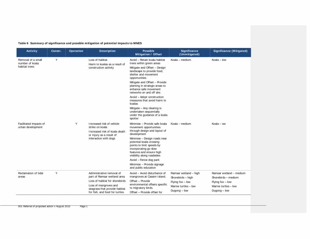
Table 6 Summary of significance and possible mitigation of potential impacts to MNES
Activity Constr. Operation Description PossibleMitigation / Offset
Significance(Unmitigated)
Significance (Mitigated)
Removal of a smallnumber of koalahabitat trees
Y Loss of habitat.Harm to koalas as a result ofconstruction activity
Avoid – Retain koala habitattrees within green areasMitigate and Offset – Designlandscape to provide food,shelter and movementopportunitiesMitigate and Offset – Provideplanting in strategic areas toenhance safe movementnetworks on and off site.
Avoid – Adopt constructionmeasures that avoid harm tokoalas
Mitigate – Any clearing isundertaken sequentiallyunder the guidance of a koalaspotter
Koala – medium Koala – low
Facilitated impacts ofurban development
Y Increased risk of vehiclestrike on koalaIncreased risk of koala deathor injury as a result ofinteraction with dogs
Minimise – Provide safe koalamovement opportunitiesthrough design and layout ofdevelopment
Minimise – Design roads nearpotential koala crossingpoints to limit speeds byincorporating go slowfeatures and ensure highvisibility along roadsidesAvoid – Fence dog park
Minimise – Provide signageand public education
Koala – medium Koala – ow
Reclamation of tidalareas
Y Administrative removal ofpart of Ramsar wetland areaLoss of habitat for shorebirds
Loss of mangroves andseagrass that provide habitatfor fish, and food for turtles.
Avoid – Avoid disturbance ofmangroves at Cassim Island.Offset – Provideenvironmental offsets specificto migratory birds.Offset – Provide offset for
Ramsar wetland – highShorebirds – highFlying fox – lowMarine turtles – lowDugong – low
Ramsar wetland – mediumShorebirds – mediumFlying fox – lowMarine turtles – lowDugong – low

001 Referral of proposed action v August 2015 Page 2
Activity Constr. Operation Description PossibleMitigation / Offset
Significance(Unmitigated)
Significance (Mitigated)
Loss of unvegetated benthichabitat.
loss of marine plants (mayinclude fish friendlystructures on jetties, publiceducation, angler bins etc.).Minimise – If feasible,schedule high disturbanceactivities to avoid periods ofhigh shore bird use.
Humpback dolphin – low Humpback dolphin – low
Dredging/ excavation Y Y Increased turbidity andsediment deposition, releaseof nutrients and othercontaminants due todredging/ excavation.
Damage to marine mammalsand reptiles duringexcavation/ dredging.
Fish, marine mammals orturtles trapped in dryexcavation areas or by siltcurtains.
Mitigate – Implement dredgemanagement plan includingassessment of material to bedredged according torelevant guidelines.
Avoid – Employ spottersduring works, cease workwhenever marine mammalsor turtles are at risk ofdamage.Minimise – Fit turtledeflection device to dredgerhead if possible.
Avoid - Design dry excavationto maximise drainage prior todewatering.Avoid - Salvage fish andrelocate prior to dewatering.Mitigate - If silt curtains areused, install at low tide.
Ramsar wetland – mediumShorebirds – mediumMarine turtles – mediumDugong – lowHumpback dolphin – low
Ramsar wetland – lowShorebirds – lowMarine turtles – lowDugong – lowHumpback dolphin – low
Dredge materialplacement
Y Y Increased turbidity andsediment deposition, releaseof nutrients and othercontaminants.
Mitigate – Design andconstruct a containmentsystem that minimises therelease of turbid water andsediment from the fillingoperation to the marineenvironment.
Ramsar wetland – mediumShorebirds – mediumMarine turtles – mediumDugong – lowHumpback dolphin – low
Ramsar wetland – lowShorebirds – lowMarine turtles – lowDugong – lowHumpback dolphin – low
Erosion andsedimentation from
Y Y Increased turbidity andsediment deposition, release
Mitigate – Design andimplement a site based
Ramsar wetland – mediumShorebirds – low
Ramsar wetland – lowShorebirds – low

001 Referral of proposed action v August 2015 Page 3
Activity Constr. Operation Description PossibleMitigation / Offset
Significance(Unmitigated)
Significance (Mitigated)
site works of nutrients and othercontaminants from activitiesother than dredging anddredge material placement.
management plan to reduceand manage runoff from thesite.
Marine turtles – lowDugong – lowHumpback dolphin – lowCoastal saltmarsh – low
Marine turtles – lowDugong – lowHumpback dolphin – lowCoastal saltmarsh – low
Change inhydrological regime
Y Y Change in the hydrologicalregime of the Ramsarwetland through dredgingand land reclamation worksand consequent changes towater quality, sedimentationand aquatic habitats
Minimise - For the adoptedconstruction methodologyoption, measures would beput in place to limit themobilisation and release offines during dredging,excavation, fill placement andcompaction.Avoid – Tailwater producedduring reclamation works willbe appropriately handled andtreated to minimise impacts.
Ramsar wetland – mediumShorebirds – lowMarine turtles – lowDugong – lowHumpback dolphin – lowCoastal saltmarsh – low
Ramsar wetland – lowShorebirds – lowMarine turtles – lowDugong – lowHumpback dolphin – lowCoastal saltmarsh – low
Disturbance of acidsulfate or potentialacid sulphatesediment
Y Y Disturbance of acid sulfate orpotential acid sulphatesediment by dredging orother site works.
Minimise – Implement acidsulfate soil managementplan, including testing of allsediment to be disturbed inaccordance with most recentQueensland guidelines.
Ramsar wetland – mediumShorebirds – lowMarine turtles – lowDugong – lowHumpback dolphin – lowCoastal saltmarsh – low
Ramsar wetland – lowShorebirds – lowMarine turtles – lowDugong – lowHumpback dolphin – lowCoastal saltmarsh – low
Hydrocarboncontamination
Y Y Contamination due to spillduring transportation of fuelor equipment refuelling.
Minimise – Implementenvironmental managementplan.
Ramsar wetland – mediumShorebirds – lowMarine turtles – lowDugong – lowHumpback dolphin – lowCoastal saltmarsh – low
Ramsar wetland – lowShorebirds – lowMarine turtles – lowDugong – lowHumpback dolphin – lowCoastal saltmarsh – low
Heavy metalcontamination
Y Y Run off from site containsheavy metals.
Minimise – Implementerosion and sediment controlplans and stormwatermanagement plan.
Ramsar wetland – mediumShorebirds – lowMarine turtles – lowDugong – lowHumpback dolphin – low
Ramsar wetland – lowShorebirds – lowMarine turtles – lowDugong – lowHumpback dolphin – low

001 Referral of proposed action v August 2015 Page 4
Activity Constr. Operation Description PossibleMitigation / Offset
Significance(Unmitigated)
Significance (Mitigated)
Coastal saltmarsh – low Coastal saltmarsh – low
Increased activityand noise
Y Y Disturbance of shorebirds,marine mammals and reptilesby increase in activity andnoise.
Avoid – Avoid disturbance ofmangroves at Cassim IslandHAT roost site
Avoid – If feasible, schedulehigh-disturbance activities toavoid periods of high shorebird use.Mitigate - Implementappropriate buffer zonesbetween the outer edge ofthe mangrove roost site andthe reclamation areaboundary.Avoid – Eliminate disturbanceat critical sites using a rangeof techniques such as fencingsites, seasonal closures,range patrols, installation ofhides and signageMinimise – Employ spottersand cease work if marinemammals and turtles in thearea are adversely impacted.Mitigate – Encourageestablishment of eco-tourismprograms that provideenvironmental education andinterpretation
Offset – Traditional Ownerinvolvement and land and seacountry management
Ramsar wetland – mediumShorebirds – highMarine turtles – lowDugong – lowHumpback dolphin – low
Ramsar wetland – lowShorebirds – lowMarine turtles – lowDugong – lowHumpback dolphin – low
Increased litter anddebris
Y Y Increase in litter and debrisresulting in entanglementand ingestion by marineturtles.
Avoid – Design andimplement site managementplan to ensure no increase inlitter or debris to marineenvironment duringconstruction and operation
Ramsar wetland – mediumShorebirds – lowMarine turtles – lowDugong – lowHumpback dolphin – low
Ramsar wetland – lowShorebirds – lowMarine turtles – lowDugong – lowHumpback dolphin – low

001 Referral of proposed action v August 2015 Page 5
Activity Constr. Operation Description PossibleMitigation / Offset
Significance(Unmitigated)
Significance (Mitigated)
including stormwatermanagement plan.Minimise – Environmentalmanagement plan includingfor example litter collectionand tangler bins, trash racks.Minimise – Public Education
Offset – Traditional Ownerinvolvement and land and seacountry management
Coastal saltmarsh – low Coastal saltmarsh – low
Facilitated increasedboat traffic
Y Increase in boat trafficleading to boat strike ofmarine mammals and turtles,damage to surroundingintertidal areas, erosion (seealso noise and activityabove).
Minimise – Utilise the existingchannel for all boat trafficMinimise – Implement speedrestrictions and ‘go slow’areas in channel.
Assist in implementation inbroader region e.g. throughfunding of boating andfisheries patrol.Minimise – public education.
Marine turtles – mediumDugong – lowHumpback dolphin – low
Marine turtles – lowDugong – lowHumpback dolphin – low
Facilitated increasedaccess
Y Increased access leading todisturbance and degradationof habitats, in particularcoastal saltmarsh.
Minimise – Limit publicaccess.
Mitigate by assisting Councilwith improved managementof nearby coastal saltmarshcommunity
Ramsar wetland – mediumShorebirds – mediumCoastal saltmarsh – medium
Ramsar wetland – lowShorebirds – lowCoastal saltmarsh – low
Increase in pestspecies
Y Y Increase in activity anddisturbance of vegetationmay lead to introduction andproliferation of pest speciesinto coastal saltmarsh andterrestrial habitats.
Minimise – Implement weedmanagement strategy.
Minimise – Restrict access tocoastal saltmarsh and nativevegetation.
Ramsar wetland – mediumCoastal saltmarsh – low
Ramsar wetland – lowCoastal saltmarsh – low

001 Referral of proposed action v August 2015 Page 1
Environmental Management Plan
Measures to avoid, minimise and mitigate impacts on matters protected under the EPBC Act during the construction andoperational phases of the project will be included in a comprehensive Environmental Management Plan (EMP) that will bedeveloped for the project. This EMP will be developed and implemented for a range of specific issues including but notlimited to:
· Vegetation management including coastal saltmarsh and weeds· Shorebirds· Marine mammals and reptiles· Fauna relocation and handling procedures· Acid sulfate soils (in accordance with the latest version of the Queensland Acid Sulfate Soil Management Guidelines)· Dredging and excavation· Placement of dredge material both during construction and maintenance phases· Stormwater· Noise· Litter· Public education· Traditional Owner participation in management of land and sea country in the vicinity of Toondah Harbour· Introduction of pest species· Waste management.

001 Referral of proposed action v August 2015 Page 2
6 Conclusion on the likelihood of significant impactsIdentify whether or not you believe the action is a controlled action (i.e. whether you think that significant impacts on thematters protected under Part 3 of the EPBC Act are likely) and the reasons why.
6.1 Do you THINK your proposed action is a controlled action?
No, complete section 6.2
X Yes, complete section 6.3
6.2 Proposed action IS NOT a controlled action.N/A
6.3 Proposed action IS a controlled actionMatters likely to be impacted
World Heritage values (sections 12 and 15A)
National Heritage places (sections 15B and 15C)
X Wetlands of international importance (sections 16 and 17B)
X Listed threatened species and communities (sections 18 and 18A)
X Listed migratory species (sections 20 and 20A)
Protection of the environment from nuclear actions (sections 21 and 22A)
Commonwealth marine environment (sections 23 and 24A)
Great Barrier Reef Marine Park (sections 24B and 24C)
A water resource, in relation to coal seam gas development and large coal mining development (sections 24Dand 24E)
Protection of the environment from actions involving Commonwealth land (sections 26 and 27A)
Protection of the environment from Commonwealth actions (section 28)
Commonwealth Heritage places overseas (sections 27B and 27C)
The referral area contains marine and terrestrial ecological values of local, state and national significance. The proposedaction has potential to result in a significant impact on the ecological character of a small portion of the Moreton BayRamsar wetland during the construction phase of the project.
Specifically, tidal works such as the excavation of quarry material from land under tidal water, capital dredging of thenavigation channel and land reclamation will result in a loss of seagrass meadow and intertidal mudflats that have aquaticecological and fisheries value and provide foraging habitat for EPBC listed migratory species, such as migratory shorebirds,dugong and marine turtles.

001 Referral of proposed action v August 2015 Page 3
7 Environmental record of the responsible party
Yes No7.1 Does the party taking the action have a satisfactory record of responsible
environmental management?X
Provide details
Walker Group Holdings Pty Ltd. is the party taking the action and has a satisfactory record ofresponsible environmental management.
Lang Walker is the majority shareholder of both Walker Group Holdings and Walker CorporationPty Ltd, which was established in the 1960s and is one of Australia’s largest private, diversifieddevelopment companies.
Walker entities have developed more than 1,000 projects in all states and territories and in allproperty sectors over a period spanning 50 years. Apart from three instances, outlined below,the companies have a strong record of responsible environmental management.
Refer http://www.walkercorp.com.au/ for more information about Walker projects.
7.2 Has either (a) the party proposing to take the action, or (b) if a permit has beenapplied for in relation to the action, the person making the application - ever beensubject to any proceedings under a Commonwealth, State or Territory law for theprotection of the environment or the conservation and sustainable use of naturalresources?
X
If yes, provide details
Walker Group Holdings Pty Ltd has not been subject to proceedings under a Commonwealth,State or Territory Law. A subsidiary of Walker Group Holdings, Kew Development Corporationwas subject to proceedings under State law:
Kew Development Corporation Pty Ltd and Heritage Victoria:
In 2007 Kew Development Corporation (a Walker subsidiary) pleaded guilty to excavating withina Tree Preservation Zone at its Kew Cottages site in Melbourne resulting in the damage to theroot of a tree. Kew Development Corporation was required to fund heritage tree protectionmeasures in Kew Cottage’s future stages. The tree was retained and is in good health today.
For transparency, Walker Corporation Pty Ltd has been subject to two proceedings under Statelaw:
Director- General Department of Environment and Climate Change (NSW) Walker CorporationPty Limited:
Walker was found guilty of clearing native vegetation without development consent on land atPicton Road, Wilton NSW on 14 May 2010.
Director- General Department of Environment and Climate Change (NSW) Walker CorporationPty Limited:
Walker was found guilty of clearing native vegetation without development consent on land atMacquariedale Road, Appin NSW on 30 November 2011.
7.3 If the party taking the action is a corporation, will the action be taken in accordancewith the corporation’s environmental policy and planning framework?
X

001 Referral of proposed action v August 2015 Page 4
If yes, provide details of environmental policy and planning framework
Walker Group Holdings Pty Ltd is not a publicly listed company and therefore there are nostatutory requirements for it to have a formal environmental policy. However, in recognising thevalue of the surrounding natural environment, Walker is committed to ensuring the proposal issustainable. All works will be controlled by conditions of consent associated with approvalsissued under State environmental law including the Sustainable Planning Act 2009; CoastalProtection Management Act 1995; Marine Parks Act 2004; Environmental Protection Act 1994;Vegetation Management Act 1999; Nature Conservation Act 1992; and Fisheries Act 1994.
7.4 Has the party taking the action previously referred an action under the EPBC Act, orbeen responsible for undertaking an action referred under the EPBC Act?
X
Provide name of proposal and EPBC reference number (if known)
Walker Group Holdings Pty Ltd has not previously referred an action under the EPBC Act or beenresponsible for undertaking an action referred under the EPBC Act.
Other Walker entities have previously referred an action, specifically:
In 2010 Walker Corporation Pty Ltd’s proposal to construct and operate a residential and marinadevelopment in in Ralphs Bay, Lauderdale was refused (EPBC 2006/3193).
In 2009 Walker Corporation Pty Ltd lodged an EPBC referral for Precinct 1 of the Buckland ParkResidential Subdivision and Development (EPBC 2009/4903). The action was determined as nota controlled action.
In 2013 Walker Group Constructions Pty Ltd lodged an EPBC referral for Precinct 2 of theBuckland Park Residential Subdivision and Development (EPBC 2013/6947). The action wasdetermined as not a controlled action.

001 Referral of proposed action v August 2015 Page 5
8 Information sources and attachments8.1 ReferencesReference material used to prepare this document is summarised in Table 7.
Table 7 Source material
AttachmentReference
Title and description Authors
Attachment G1 Expert advice in ecology (marine and terrestrial) and coastal processes forinput to the preparation of a structure plan and development scheme forToondah Harbour and Weinam Creek Priority Development Areas (January2014)(Publicly available at http://www.redland.qld.gov.au/Business/Pages/PDA-initial-technical-reports)The report outlines the findings of assessment of fauna and flora, theinvestigation of environmental constraints and the assessment of options andstrategies for the PDAs in relation to matters on national, state and localenvironmental significance.
BAAM and frcenvironmental onbehalf of RCC
Attachment G2 Migratory Shorebird Assessment – Toondah Harbour and Weinam CreekPriority Development Areas (November 2014)The report details the results of a survey and assessment of migratoryshorebird species abundances and habit uses with the Toondah Harbour andWeinam Creek PDAs.
BAAM for frcenvironmental onbehalf of Walker
Attachment G3 Toondah Harbour PDA – Ecological studies in support of works areadetermination (November 2014)The report describes the marine plants and benthic habitat currently withinand adjoining the referral area, the aquatic fauna associated with that habitatand discusses how the proposed action may impact habitat and associatedflora and fauna.
frc environmental forWalker
Attachment G4 Toondah Harbour and Weinam Creek Priority Development Area migratoryshorebird survey results (July 2015)This technical memorandum for Palaris on behalf of Walker for the purposeof providing a summary of the results of three summer season and onewinter migratory shorebird surveys of the Toondah Harbour and WeinamCreek Priority Development Areas undertaken between January and June2015.
BAAM for Walker

001 Referral of proposed action v August 2015 Page 6
8.2 Reliability and date of informationA literature and data review was undertaken to provide a description of the aquatic and terrestrial habitats and floral andfaunal communities and species of Toondah Harbour contained in the December 2013 BAAM report for RCC. This included areview and searches of:
· relevant previous surveys undertaken by frc environmental and BAAM· other published reports and literature· listed threatened aquatic and terrestrial species or ecological communities on the Commonwealth’s EPBC Act online
Protected Matters Search Tool database
This information provided the study team with details of EVNT species, ecologically significant habitat and communities,habitat and communities particularly sensitive to disturbance (including those protected under federal, state and locallegislation and guidelines) and species and communities of scientific, educational, cultural and historical interest. The likelyoccurrence and distribution of exotic species was also determined.
The reliability and relevance of information sources were evaluated to identity key knowledge gaps. This informed thedesign of focused field surveys to verify the information gathered during the desktop study and to fill any information gaps.
Marine ecology field surveys were completed by frc environmental over three days between 5 and 8 July 2013 to assess thecurrent condition, value and extent of marine and estuarine systems in the Toondah Harbour area. The surveys includedground-truthing of habitat mapping to:
· verify habitat boundaries using GPS· characterise habitats (including mangroves, seagrass, soft sediment benthos and rocky reef) according to species
composition and cover· estimate habitat quality and value using a qualitative assessment of parameters including abundance, species
composition, per cent cover, and presence and abundance of epiphytes and epifauna· obtain a photographic record of habitat types, including underwater videography· observe coastal processes such as areas of siltation or erosion.
All surveys were completed in accordance with relevant permits issued to frc environmental.
Terrestrial ecology field surveys were undertaken by terrestrial ecologists from BAAM in fine, sunny weather conditions on 5July 2013. The surveys involved ground-truthing of existing habit mapping, including:
· verification of vegetation mapping· assessment of the actual or likely presence of significant terrestrial species and associated habitat (Commonwealth,
state and local species)· verification of habitat boundaries using GPS plotters, and characterisation of the quality, condition and connectivity of
the habitats present· obtaining a photographic record of reach of the habitat types present.
A particular focus of the terrestrial fauna study was surveying all non-juvenile habitat trees for koala (i.e. a food tree of theEucalyptus, Corymbia, Melaleuca or Lophostemon genera or a preferred shelter species such as Angophora species, with aheight of more than four metres or a trunk with a circumference of more than 31.5 centimetres at 1.3 metres above theground). This involved identifying and taking a GPS point at each non-juvenile habitat tree (or group of clustered trees),estimating the tree height and searching the base of the tree for koala scats as confirmation of recent koala activity.
Migratory Shorebird Assessment – Toondah Harbour and Weinam Creek Priority Development Areas
The migratory shorebird assessment was undertaken by BAAM for frc environmental on behalf of Walker in November2014. The assessment combined two field surveys spaced several days apart with a review and assessment of survey datasourced from the Queensland Wader Study Group, a special interest group within Birds Queensland that monitors shorebirdpopulations in Queensland and conducts regular shorebird surveys of parts of the Queensland coast that have largeshorebird populations. A desktop review of published information was also undertaken to review migratory shorebirdhabitat requirements and sensitivity to habitat change and disturbance.
The field surveys were conducted in accordance with the survey guidelines outlined in the EPBC Act Policy Statement 3.21:Significant Impact Guidelines for 36 Migratory Shorebird Species (DEWHA 2009). Specifically, the surveys were conductedas close to the time of low tide as practicable and at a maximum of two hours either side of low tide. The surveys forroosting shorebirds were conducted as close to the time of high tide as practicable and at a maximum of two hours eitherside of high tide. The surveys were not undertaken during periods of high rainfall or strong winds or when activities thatcause disturbance to the birds were taking place.

001 Referral of proposed action v August 2015 Page 7
Toondah Harbour PDA – Ecological studies in support of works area determination (November 2014)
Surveys of habitats and associated flora and fauna were conducted from 5 to 6 November 2014 by frc environmental.Habitats were assessed visually and differences in habitat were marked using a handheld GPS. The GPS waypoints werealso compared to recent aerial imagery and then mapped. Marine plant communities were classified according to thedominant species present and the relevant understorey or sub-dominant species present.
The marine plant communities were also qualitatively assessed for their relative value to aquatic ecology and fisheries. Theavailability of physical habitat for fauna, the amount of disturbance, the ponding of water and the relative proximity of eachpoint to permanent water at low tide (to assess the likely frequency of tidal inundation) were also assessed.
Toondah Harbour and Weinam Creek Priority Development Area migratory shorebird survey results (July2015)
BAAM has prepared this technical memorandum for Palaris on behalf of Walker for the purpose of providing a summary ofthe results of three summer season and one winter migratory shorebird surveys of the Toondah Harbour and WeinamCreek Priority Development Areas undertaken between January and June 2015.
The study approach combined a desktop review with field surveys of shorebirds utilising shoreline and intertidal habitatsduring each of the low tide and high tide phases of the tide cycle.
The desktop review combined an examination of aerial imagery for the area and a review of available information onshorebird use of the vicinity of the Toondah Harbour and Weinam Creek PDA areas, principally an earlier survey undertakenby BAAM October-November 2014 (BAAM 2014), to identify appropriate habitat areas to focus the field survey on.
The field surveys were undertaken by Dr Penn Lloyd (Principal Ecologist) between December 2014 and June 2015. Thesurveys for foraging shorebirds were conducted in accordance with the survey guidelines outlined in the Commonwealth’sEPBC Act Policy Statement 3.21: Significant Impact Guidelines for 36 Migratory Shorebird Species (DEWHA 2009).

001 Referral of proposed action v August 2015 Page 8
8.3 Attachmentsü
attached Title of attachment(s)You must attach figures, maps or aerial photographs showing the
project locality (section 1)ü
ü
Attachment A: RegionalContext (figure)
Attachment B: Local Context(figure)
Attachment C: Land tenure(figure)
Attachment D: MNES –Listed threatened speciesand ecological communities(figure)
Attachment E: Listedmigratory species (figure)
Attachment F: StormwaterDrainage Plan (drawing)
Attachment H: GIS files –Referral Area
GIS file delineating the boundary of the referralarea (section 1)
figures, maps or aerial photographs showing thelocation of the project in respect to any mattersof national environmental significance orimportant features of the environments (section3)
ü Attachments A - F
If relevant, attach copies of any state or local governmentapprovals and consent conditions (section 2.5)
N/A
copies of any completed assessments to meetstate or local government approvals andoutcomes of public consultations, if available(section 2.6)
N/A
copies of any flora and fauna investigations andsurveys (section 3)
ü Attachment G1 - Expertadvice in ecology (marineand terrestrial) and coastalprocesses for input to thepreparation of a structureplan and developmentscheme for Toondah Harbourand Weinam Creek PriorityDevelopment Areas (frcenvironmental and BAAMEcological Consultants,December 2013)
Attachment G2 - MigratoryShorebird Assessment –Toondah Harbour andWeinam Creek PriorityDevelopment Areas (BAAMEcological Consultants).
Attachment G3 - ToondahHarbour PDA – Ecologicalstudies in support of worksarea determination (frcenvironmental, November2014)
Attachment G4 - Toondah
001 Referral of proposed action v August 2015 Page 9
Harbour and Weinam CreekPriority Development Areamigratory shorebird surveyresults (BAAM EcologicalConsultants)
technical reports relevant to the assessment ofimpacts on protected matters that support thearguments and conclusions in the referral(section 3 and 4)
ü As above
report(s) on any public consultationsundertaken, including with Indigenousstakeholders (section 3)


001 Referral of proposed action v August 2015 Page 12
REFERRAL CHECKLISTHAVE YOU:
ü Completed all required sections of the referral form?
ü Included accurate coordinates (to allow the location of the proposed action to bemapped)?
ü Provided a map showing the location and approximate boundaries of the projectarea?
ü Provided a map/plan showing the location of the action in relation to any mattersof NES?
ü Provided a digital file (preferably ArcGIS shapefile, refer to guidelines atAttachment A) delineating the boundaries of the referral area?
ü Provided complete contact details and signed the form?
ü Provided copies of any documents referenced in the referral form?
ü Ensured that all attachments are less than three megabytes (3mb)?
ü Sent the referral to the Department (electronic and hard copy preferred)?