1) Section 404(b)(1) Evaluation 2) Wetlands Mitigation ... · 1) Section 404(b)(1) Evaluation 2)...
105
Attachment B 1) Section 404(b)(1) Evaluation 2) Wetlands Mitigation Opportunities Report 3) 404 (r) Letter From U.S. Environmental Protection Agency (EPA) Attachment B to the ALP Project Final Supplemental Environmental Impact Statement (FSEIS) includes the Section 404(b)(1) Evaluation in compliance with the U.S. Environmental Protection Agency (EPA) Guidelines under 40 CFR Part 230. This Evaluation is in support of Reclamation's intention to seek Clean Water Act compliance through Section 404(r) provisions which exempt Reclamation from the requirements to obtain a Section 404 Permit for construction activities resulting in a discharge of dredged or fill material into waters of the United States. This attachment also includes a Wetlands Mitigation Opportunities Report and the 404(r) letter from EPA.
Transcript of 1) Section 404(b)(1) Evaluation 2) Wetlands Mitigation ... · 1) Section 404(b)(1) Evaluation 2)...

Attachment B
1) Section 404(b)(1) Evaluation
2) Wetlands Mitigation Opportunities Report
3) 404 (r) Letter From U.S. Environmental Protection Agency (EPA)
Attachment B to the ALP Project Final Supplemental Environmental Impact Statement (FSEIS) includes the Section 404(b)(1) Evaluation in compliance with the U.S. Environmental Protection Agency (EPA) Guidelines under 40 CFR Part 230. This Evaluation is in support of Reclamation's intention to seek Clean Water Act compliance through Section 404(r) provisions which exempt Reclamation from the requirements to obtain a Section 404 Permit for construction activities resulting in a discharge of dredged or fill material into waters of the United States. This attachment also includes a Wetlands Mitigation Opportunities Report and the 404(r) letter from EPA.

Attachment B - Part 1
ANIMAS LA-PLATA PROJECT
Final 404(b)(1) Evaluation
Prepared for:
U.S. Department of the Interior Bureau of Reclamation Upper Colorado Region
Prepared by:
Navigant Consulting, Inc. Sacramento, California
July 2000

B-i
TABLE OF CONTENTS
1.0 INTRODUCTION ..........................................................................................................................B-3
1.1 Background ..........................................................................................................................B-3 1.2 404(b)(1) Guidelines ............................................................................................................B-3
2.0 ALTERNATIVES ANALYSIS ......................................................................................................B-5
2.1 Introduction ..........................................................................................................................B-5 2.2 Determination of Project Purpose ........................................................................................B-5 2.3 Potential Water Sources .......................................................................................................B-8 2.4 Development and Evaluation of Alternatives.......................................................................B-8 2.5 Evaluation of Alternatives Summary....................................................................................B-8 2.6 Selection of Practicable Alternatives....................................................................................B-8
2.6.1 Identification of Refined Alternatives...............................................................B-8 2.6.2 Determination of Practicability.........................................................................B-9
3.0 POTENTIAL IMPACTS ON PHYSICAL AND CHEMICAL CHARACTERISTICS OF THE AQUATIC ECOSYSTEM (SUBPART C) ...................................................................................B-10
3.1 Substrate (230.20) ..............................................................................................................B-10 3.1.1 Refined Alternative 4: Ridges Basin Reservoir (120,000 af).........................B-10
3.1.2Refined Alternative 6: Animas River Citizen’s Coalition Conceptual Alternative ........................................................................................ B-12
3.2 Suspended Particulate Materials/Turbidity (230.21) ..........................................................B-13 3.2.1 Refined Alternative 4: Ridges Basin Reservoir (120,000 af).........................B-13
3.2.2Refined Alternative 6: Animas River Citizen’s Coalition Conceptual Alternative ........................................................................................ B-14
3.3 Water (230.22) ...................................................................................................................B-15 3.3.1 Refined Alternative 4: Ridges Basin Reservoir (120,000 af)..........................B-15 3.3.2 Refined Alternative 6: Animas River Citizen’s Coalition Conceptual Alternative .....................................................................................................B-18
3.4 Current Patterns and Water Circulation (230.23)...............................................................B-19 3.4.1 Refined Alternative 4: Ridges Basin Reservoir (120,000 af)..........................B-20 3.4.2 Refined Alternative 6: Animas River Citizen’s Coalition Conceptual Alternative .....................................................................................................B-22
3.5 Normal Water Fluctuations (230.24)..................................................................................B-24 3.5.1 Refined Alternative 4: Ridges Basin Reservoir (120,000 af)..........................B-24 3.5.2 Refined Alternative 6: Animas River Citizen’s Coalition Conceptual Alternative .....................................................................................................B-25
3.6 Salinity Gradients (230.25) ................................................................................................B-25
4.0 POTENTIAL IMPACTS ON BIOLOGICAL CHARACTERISTICS OF THE AQUATIC ECOSYSTEM (SUBPART D)......................................................................................................B-26
4.1 Threatened and Endangered and Candidate Species (230.30)............................................B-26 4.1.1 Refined Alternative 4: Ridges Basin Reservoir (120,000 af)..........................B-27
4.1.2Refined Alternative 6: Animas River Citizen’s Coalition Conceptual Alternative ........................................................................................ B-29
4.2 Fish, Crustaceans, Mollusks and Other Aquatic Organisms...............................................B-30 4.2.1 Refined Alternative 4: Ridges Basin Reservoir (120,000 af)..........................B-30 4.2.2 Refined Alternative 6: Animas River Citizen’s Coalition Conceptual Alternative .....................................................................................................B-32

B-ii
4.3 Impacts on Other Wildlife (230.32) ...................................................................................B-33 4.3.1 Refined Alternative 4: Ridges Basin Reservoir (120,000 af)..........................B-33 4.3.2 Refined Alternative 6: Animas River Citizen’s Coalition Conceptual Alternative .....................................................................................................B-36
5.0 POTENTIAL IMPACTS ON SPECIAL AQUATIC SITES (SUBPART E) ...............................B-37
5.1 Sanctuaries and Refuges (230.40) ......................................................................................B-37 5.1.1 Refined Alternative 4: Ridges Basin Reservoir (120,000 af)..........................B-37 5.1.2 Refined Alternative 6: Animas River Citizen’s Coalition Conceptual Alternative .....................................................................................................B-37
5.2 Wetlands (230.41)..............................................................................................................B-37 5.2.1 Refined Alternative 4: Ridges Basin Reservoir (120,000 af)..........................B-37 5.2.2 Refined Alternative 6: Animas River Citizen’s Coalition Conceptual Alternative .....................................................................................................B-40
5.3 Mud Flats (230.42).............................................................................................................B-43 5.4 Vegetated Shallows (230.43) .............................................................................................B-43 5.5 Riffle and Pool Complexes (230.44)..................................................................................B-43
5.5.1 Refined Alternative 4: Ridges Basin Reservoir (120,000 af)..........................B-43 5.5.2 Refined Alternative 6: Animas River Citizen’s Coalition Conceptual Alternative .....................................................................................................B-45
6.0 POTENTIAL IMPACTS ON HUMAN USE CHARACTERISTICS..........................................B-47
6.1 Municipal and Private Water Supplies ...............................................................................B-47 Refined Alternative 4: Ridges Basin Reservoir (120,000 af).......................................B-47 Refined Alternative 6: Animas River Citizen’s Coalition Conceptual Alternative ......B-48
6.2 Recreational and Commercial Fisheries .............................................................................B-48 Refined Alternative 4: Ridges Basin Reservoir (120,000 af).......................................B-48 Refined Alternative 6: Animas River Citizen’s Coalition Conceptual Alternative ......B-49
6.3 Water Related Recreation...................................................................................................B-49 Refined Alternative 4: Ridges Basin Reservoir (120,000 af).......................................B-49 Refined Alternative 6: Animas River Citizen’s Coalition Conceptual Alternative ......B-50
6.4 Aesthetics ...........................................................................................................................B-50 Refined Alternative 4: Ridges Basin Reservoir (120,000 af).......................................B-50 Refined Alternative 6: Animas River Citizen’s Coalition Conceptual Alternative ......B-51
6.5 Parks, Natural and Historical Monuments, National Seashores, Wilderness Areas, Research Sites, and Similar Preserves ................................................................................B-51
Refined Alternative 4: Ridges Basin Reservoir (120,000 af).......................................B-51 Refined Alternative 6: Animas River Citizen’s Coalition Conceptual Alternative ......B-52
7.0 ACTIONS TO MINIMIZE ADVERSE EFFECTS AND PRACTICABLE STEPS TO MINIMIZE POTENTIAL ADVERSE IMPACTS (SUBPART H) ..................................................................B-54
7.1 Actions Concerning the Location of the Discharge (230.70) .............................................B-54 7.2 Actions Controlling the Material to be Discharged, the Material after Discharge, the Method of Dispersion and Related Technology (230.71, 230.72, 230.73, and 230.64)B-54 7.3 Actions Affecting Plant and Animal Populations (230.75) ................................................B-56
Water Quality Mitigation Actions................................................................................B-57 Special Status Species..................................................................................................B-58
7.4 Actions Affecting Human Use (230.76).............................................................................B-58 7.5 Other Actions (230.77).......................................................................................................B-58
8.0 EVALUATION AND TESTING .................................................................................................B-59
8.1 General – Evaluation of Dredged or Fill Material ..............................................................B-59

B-iii
9.0 LEAST DAMAGING PRACTICABLE ALTERNATIVE ..........................................................B-60
10.0 FACTUAL DETERMINATIONS (230.11) .................................................................................B-68
10.1 Physical Substrate Determinations .....................................................................................B-68 10.2 Water Circulation and Fluctuation Determinations ............................................................B-68 10.3 Suspended Particulate Materials and Turbidity Determinations.........................................B-71 10.4 Contaminant Determinations..............................................................................................B-71 10.5 Aquatic Ecosystem and Organism Determinations ............................................................B-73 10.6 Proposed Disposal Site Determinations..............................................................................B-75 10.7 Determination of Cumulative Impacts on the Aquatic Ecosystem .....................................B-76 10.8 Determination of Secondary Effects on the Aquatic Ecosystem ........................................B-77
11.0 STATUTORY REQUIREMENTS (230.10(B)) ...........................................................................B-78
11.1 State Water Quality Standards............................................................................................B-78 11.2 Toxic Effluent Standards....................................................................................................B-79 11.3 Endangered Species Act.....................................................................................................B-79
Animals........................................................................................................................B-79 Plants ........................................................................................................................B-79
11.4 Marine Sanctuaries.............................................................................................................B-80
12.0 SIGNIFICANT DEGRADATION ANALYSIS (230.10C)..........................................................B-81
12.1 Human Health and Welfare................................................................................................B-81 12.2 Life Stages of Aquatic Life and Other Wildlife .................................................................B-81 12.3 Aquatic Ecosystem Diversity and Productivity ..................................................................B-81 12.4 Recreational, Aesthetics and Economic Analysis...............................................................B-81 12.5 Final Significant Determinations........................................................................................B-81
13.0 FINDINGS OF COMPLIANCE WITH THE RESTRICTIONS ON DISCHARGE....................B-82
REFERENCES........................................................................................................................................B-83
List of Tables 2-1 Summary of Future Uses of M&I Water by Indians and Non-Indians .............................. B-6 2-2 Regional Population Growth and M&I Water Needs La Plata and Montezuma Counties,
Colorado and San Juan County, New Mexico (Years 2000–2100) .................................. B-7 4-1 Special Status Plant Species Potentially Occurring Within the Colorado and New Mexico
Region of the Project Area ................................................................................B-25 4-2 Special Status Wildlife Species Potentially Occurring Within the Project Area ..................B-26 4-3 Special Status Fish Species Potentially Occurring Within Region of the Project Area..........B-26 5-1 Examples of Representative Widths of Canal Wetland Vegetation .................................B-42 9-1 Comparison of Environmental Impacts ..................................................................B-60 9-2 Functional Capability of Wetlands .......................................................................B-63 9-3 Wildlife and Fish Habitat Functional Capability of Wetlands .......................................B-65

B-1
EXECUTIVE SUMMARY
An evaluation under Section 404(b)(1) of the Clean Water Act (CWA) has been prepared by the U.S. Bureau of Reclamation (Reclamation) to analyze and describe the potential impacts from proposed discharges of dredged or fill material into the waters of the United States resulting from construction and operation of the proposed Animas-La Plata Project (ALP Project) in Colorado and New Mexico. This 404(b)(1) Evaluation was prepared in support of the requirements of Section 404 of the CWA (Public Law (PL) 92- 500, as amended), and U.S. Environmental Protection Agency (EPA) Guidelines (40 Code of Federal Regulations (CFR) Part 230 et seq. Guidelines) Specifically, the 404(b)(1) Evaluation was prepared by Reclamation to meet the requirements of Section 404(r) of the CWA.
The 404(b)(1) Evaluation followed EPA Guidelines, which are weighted toward restoring and maintaining the chemical, physical, and biological integrity of waters of the United States by controlling discharges. The evaluation addressed ALP Project purposes, practicable alternatives, cumulative effects, mitigation, and made factual determinations of the potential impacts of the ALP Project to the waters of the United States.
Water demands that included Municipal and Industrial (M&I), energy, and livestock uses were identified that would meet the ALP Project purpose and need. Potential water supplies to meet project water demands were identified and evaluated in terms of yield, reliability, quality and availability. Water supplies evaluated included surface water, groundwater, water conservation and acquisition of water rights. Potential water sources to meet ALP Project water allocation needs were identified.
Sources of water were evaluated in light of water allocation needs for each of the water users (Southern Ute Indian Tribe and Ute Mountain Ute Tribe (Colorado Ute Tribes), Navajo Nation, Animas-La Plata Water Conservancy District (ALPWCD), and San Juan Water Commission (SJWC)). A number and sizes of facilities to store and deliver water to each of these water users separately, and in various combinations, were evaluated. Alternatives proposed by a process initiated by then Colorado Governor Romer and Lt. Governor Schoettler, and Secretary of the Interior, Bruce Babbitt, were also considered.
The purpose of the 404(b)(1) Evaluation is to document how the project minimizes adverse impacts on aquatic resources in fulfilling the basic project purpose and need. The environmental impacts of alternatives were considered through a two-step process. Ten different alternatives were identified. The ten alternatives, included storage and conveyance features, and water supply options that appeared feasible. A Level I assessment of practicability was undertaken, evaluating cost, logistics (i.e., yield, reliability, availability, and location), and technology. The 10 alternatives were subjected to a Level I assessment for the identified level of water demand. Eight alternatives were eliminated from consideration, and the remaining alternatives were subject to additional analysis of the relative environmental impacts.
Two alternatives that were evaluated warranted refinement due to similar outcome of the comparison of their overall environmental effects, and because each represents a significantly different approach in meeting the purpose and need of the ALP Project (one is principally a structural alternative and the other a non-structural alternative). Even with these refinements, several concerns arose about the practicability of the non-structural alternative, Refined Alternative 6, in the areas of: (1) socioeconomic issues; (2) changes in water use; (3) timing; and (4) Indian Trust Assets (ITAS). Reclamation found that Refined Alternative 4 would comply with the requirements of the EPA Guidelines (Subparts B through G). Refined Alternative 4 would have fewer overall impacts to wetlands and endangered species (southwestern willow flycatcher habitat) than Refined Alternative 6.

B-2
Construction and operation of the ALP Project as proposed under Refined Alternative 4 would comply with the 2000 Biological Opinion of the U.S. Fish and Wildlife Service (Service) (Service 2000a) in that it would not jeopardize the continued existence of listed species (see Section 7). Reclamation concluded that Refined Alternative 4 would comply with the 404(b)(1) guidelines and that Refined Alternative 4 is the least damaging practicable alternative. A detailed discussion of the relative impacts of Refined Alternatives 4 and 6 is contained in Section 9.0 of the 404(b)(1) Evaluation.
B-3
1.0 INTRODUCTION
1.1 Background
This evaluation under Section 404(b)(1) of the Clean Water Act (CWA) has been prepared to analyze and describe the potential impacts from proposed discharges of fill material into the waters of the United States as a result of the construction and operation of the proposed Animas-La Plata Project (ALP Project) in Colorado and New Mexico. This 404(b)(1) Evaluation is prepared in support of the requirements of Section 404 of the CWA (PL 92-500, as amended), and the Environmental Protection Agency Guidelines (40 CFR Part 230 et seq.). Specifically, the 404(b)(1) Evaluation is prepared to meet the requirements of Section 404(r) of the CWA.
Previous 404(b)(1) Evaluations were prepared to accompany a Final Environmental Impact Statement (FES) on the ALP Project in 1980 (Reclamation 1980), a Draft Supplement to the FES in 1992 (Reclamation 1992), and a Final Supplement to the FES in 1996 (Reclamation 1996). The current 404(b)(1) Evaluation reflects proposed changes in the project since 1980, 1992, and 1996. It accompanies the Final Supplemental Environmental Impact Statement (FSEIS) prepared in accordance with the National Environmental Policy Act (NEPA).
1.2 404(b)(1) Guidelines
The 404(b)(1) Guidelines, contained in Title 40 of the Code of Federal Regulations (CFR), Part 230 et seq., are the criteria used in evaluating discharges of fill (or discharges of dredged materials) in waters of the United States under Section 404 of the CWA Act. These are applicable to all 404 permit decisions.
The Guidelines were developed by the Environmental Protection Agency (EPA) in conjunction with the Secretary of the Army acting through the Chief of Engineers and have the full force and effect of law. The Guidelines are consistent with policies expressed in the CWA and are intended to implement those policies. The Guidelines are weighted toward restoring and maintaining the chemical, physical, and biological integrity of waters of the United States by controlling discharges. Basic to the Guidelines is an understanding that fill (or dredged) material should not be discharged into such waters unless it is demonstrated that such discharges would not have unacceptable adverse impacts either individually or in combination with existing and/or probable impacts of other activities affecting the environment. A Section 404(b)(1) Evaluation is intended to provide demonstration of the compliance, or the lack thereof, with the Guidelines.
The Guidelines say that there must be no other practicable alternative which is less damaging to the aquatic environment, unless the least damaging alternative would have other significant adverse environmental consequences. This is a technical analysis based on many factors that are evaluated in light of the purpose and need for the project under review.
A number of critical items must be evaluated for each project. These include the basic project purpose, practicable alternatives, cumulative effects, and impact mitigation, as well as the factual determinations. Key issues must be decided in arriving at a determination of compliance or non-compliance. The project must not cause or contribute to significant degradation of waters of the United States, and all appropriate and practicable measures for avoiding or minimizing potential adverse impacts of the discharge on the aquatic ecosystem must be taken.
Section 230.10 (b) requires that the project comply with State water quality standards, the federal Endangered Species Act (ESA), and other pertinent statutory provisions. Section 230.11 of the Guidelines sets forth the factual determinations used in deciding compliance. These determinations are as follows:

B-4
q Physical substrate;
q Water circulation, fluctuation, and salinity;
q Suspended particulate/turbidity;
q Contaminant;
q Aquatic ecosystem and organism;
q Proposed disposal site ;
q Cumulative effects on the aquatic ecosystem; and
q Secondary effects on the aquatic ecosystem.
Section 230.12 requires a finding of compliance or non-compliance with the restrictions on discharge.
Subparts C through F of the Guidelines evaluate the potential impacts of the fill activity on physical and chemical characteristics of the aquatic ecosystem, special aquatic sites, and human use characteristics respectively. Subpart G of the Guidelines sets forth evaluation and testing procedures to provide information necessary to reach the determinations in Subpart B. Subpart H of the Guidelines lists actions to minimize adverse effects of the discharge.
The following sections discuss the definition of the basic project purpose, the selection process for project alternatives, and the Subparts B through H evaluations.

B-5
2.0 ALTERNATIVES ANALYSIS
2.1 Introduction
EPA 404(b)(1) Guidelines are the substantive environmental criteria used in evaluating activities that discharge dredge or fill material into the “waters of the United States”. Section 230.10(a) of the Guidelines states that:
“…no discharge of dredges or fill material shall be permitted if there is a practicable alternative to the proposed discharge which would have less adverse impact on the aquatic ecosystem, so long as the alternative does not have other significant adverse environmental consequences.”
The hierarchical structure of the Guidelines encourages activities that avoid discharges. The alternative analysis required by Section 230.10(a) is designed to achieve the basic project purpose with the minimal adverse environmental impact.
For the 404 (b)(1) Evaluation for the ALP Project, the following steps were used in the Section 230.10(a) process to review potential alternatives:
q Project purpose and need were defined
q A range of project alternatives was identified
q Evaluation was undertaken to identify practicable alternatives
q The environmental impacts of practicable alternatives were identified.
2.2 Determination of Project Purpose
The definition of basic project purpose is essential to an adequate 404(b)(1) Evaluation of the least damaging practicable alternative. The basic project purpose drives the definition and evaluation of alternatives.
The project purpose for the ALP Project is:
“…..to implement the Settlement Act by providing the Ute Tribes an assured long-term water supply and water acquisition fund in order to satisfy the Tribes’ senior water rights claims as quantified in the Settlement Act, and to provide for identified municipal and industrial water needs in the Project area.“
The municipal and industrial (M&I) needs that would be met by fulfilling the purpose of the ALP Project include the following:
q Provide a dependable long-term water supply for Colorado Ute Tribes, and neighboring Indian and non-Indian community water needs, including the Navajo Nation in and near Shiprock, New Mexico, and the Animas-La Plata Water Conservancy District (ALPCD) and San Juan Water Commission (SJWC).
As noted by the project purpose, the water supply to be developed and provided to the Colorado Ute Tribes is in satisfaction of their Federal reserved water rights claims and settles litigation before the District Court, Water Division Number 7, of the State of Colorado. These Federal reserved water rights claims are based on Winters v. United States, 207 U.S. 564 (1908), which states that the establishment of an Indian

B-6
Reservation carries with it an implied reservation of the amount of water necessary to fulfill its purposes with a priority date no later than the creation of the reservation. At the time of the reservation, therefore, there was reserved for the Tribes an amount of water sufficient to satisfy both present and future needs. In settling Indian water rights claims based on the Winters doctrine, the federal government has specified that it seeks to ensure that Indians receive equivalent benefits for rights which they, and the United States as trustee, may release as part of a settlement (55 Fed. Reg. No. 9223). Accordingly, a settlement should provide the Tribes a long-term supply of water and respect the Tribe’s sovereign right to determine the specific uses for which the water supply will be applied. In sum, the purpose of this action is not merely to provide the Colorado Ute Tribes a supply of M&I water, but to do so in a manner that resolves, once and for all, their water rights claims.
Since a portion of the water supply provided is for future uses, the exact manner in which the water will be used in uncertain. The Tribes have not determined precisely the use to which the Settlement water supply and acquisition fund will be applied. Nonetheless, for purposes of analysis, it is appropriate to consider potential end uses for the water. The Tribes have proposed a conceptual plan for potential uses, which include municipal, industrial, recreation and tourism, energy development, raising of livestock and regional water supply options (Table 2-1). The demand for housing will most likely be met in the near future, the other demands would be satisfied in future development opportunities. As the future unfolds, however, the Tribes may decide to use their water in completely different ways to foster economic development on their respective reservations. The scenarios do not necessarily represent tribal commitments for using their water, and are not binding on the tribes in any way.
The San Juan River Basin is experiencing population growth that will increase the demand for water, both for household and for commercial, industrial, recreational, and community infrastructure needs that accompany population growth. Table 2-2 shows the expected growth rates for the three-county area (La Plata and Montezuma counties in Colorado and San Juan County in New Mexico).
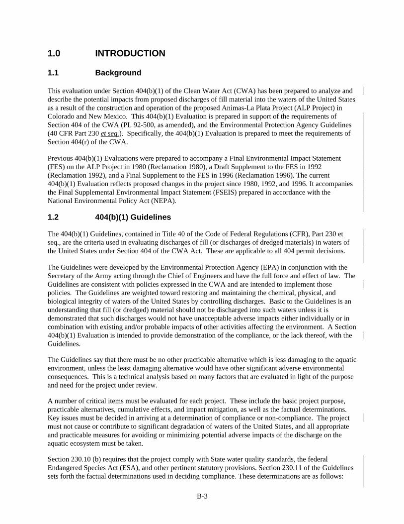
Table 2-1 Summary of Future Uses of M&I Water
by Indians and Non-Indians
Category of M&I Use Diversion
(afy) Depletion
(afy)
Non-Binding M&I Use by Southern Ute Indian Tribe
Florida Mesa Housing 140 70
Animas River Basin Housing 140 70
La Plata River Basin Housing 140 70
Animas Industrial Park 40 20
Ridges Basin Golf Course 796 398
Ridges Basin Resort 44 22
Coal Mine 830 415
Coal Fired Power Plant 27,000 13,500
Livestock and Wildlife 30 15
Southern Ute Total 29,160 14,580
Non-Binding M&I Use by Ute Mountain Indian Ute Tribe La Plata Housing 280 140
Mancos Canyon Golf Course 978 489
Mancos Canyon Resort 33 17
La Plata Basin Resort 30 15
La Plata Basin Golf Course 626 313
La Plata Basin Dude Ranch 10 5
B-7
Table 2-1 (continued)
Summary of Future Uses of M&I Water by Indians and Non-Indians
Category of M&I Use Diversion
(Acre-feet per year) Depletion
(Acre-feet per year)
Gas-Fired Power Plant 4,600 2,300
Livestock and Wildlife 40 20
Ute Mountain Ute Total 6,597 3,299
Non-Binding Regional M&I Water Supply Demand Durango, Co. 15,338 7,669
Bloomfield, N.M. & upstream 4,533 2,267
Farmington, N.M. 28,373 14,187
Florida Mesa, Co. 7,016 3,508
Red Mesa Plateau, Co. 2,105 1,052
Kirtland, N.M. 7,016 3,508
Aztec, N.M. 4,911 2,456
Less –Animas La Plata Water Conservancy District Allocation
(5,200) (2,60)
Less- San Juan Water Commission Allocation (20,800) (10,400)
Total Regional Supply 43,292 21,646
Total Ute Settlement 79,050 39,525
Other Binding Uses Navajo Nation 4,680 2,340
Animas La Plata Water District 5,200 2,600
San Juan Water Commission 20,800 10,400
Reservoir Evaporation 2,235 2,235
Total for Other Uses 32,915 17,575
TOTAL WATER USE 111,965 57,100
Table 2-2 Regional Population Growth and M&I Water Needs
La Plata and Montezuma Counties, Colorado and San Juan County, New Mexico (2000 – 2100)
2000 2010 2020 2030 2040 2050 2060 2070 2080 2090 2100
Regional Population Growth
177,307 211,780 244,907 279,402 327,060 382,990 448,690 525,870 616,610 723,310 848,840
Regional Water Needs (Acre-feet/ Year)
35,551 42,463 49,105 56,022 65,577 76,792 89,965 105,440 123,634 145,028 170,197
Population growth between 1970 and 1990 approached 3 percent per year on both the Southern Ute Indian and Ute Mountain Ute Reservations. More recently, however, the enrollments of both Tribes have been increasing approximately 1.3 percent to 1.5 percent per year. The U.S. Census Bureau (1990) anticipates that Colorado’s American Indian population will grow at an average annual rate of 1.9 percent through the year 2025 and then decline to 1.1 percent by 2065. Based on these growth rates, the population of the Colorado Ute Tribes is expected to increase from 3,287 in 1998 to approximately 15,000 by the year 2100.

B-8
2.3 Potential Water Sources
Section 2.1.2 of Chapter 2 of the FSEIS provides a description and summary of potential sources of water to meet future water uses in the San Juan River Basin.
2.4 Development and Evaluation of Alternatives
Chapter 2 of the FSEIS provides an overview of the development and evaluation of alternatives.
2.5 Evaluation of Alternatives Summary
Chapter 2 of the FSEIS provides the details of the alternatives evaluation process involving the environmental impacts, purpose and need, and technical and economic factors of the ALP Project.
2.6 Selection of Practicable Alternatives
2.6.1 Identification of Refined Alternatives
Based on the assessment of environmental, purpose and need, and technical/economic factors. Alternative 4 and Alternative 6 were identified for further consideration in the FSEIS. This determination requires an assumption that Alternative 6 could, in theory, meet the project purpose and need. However, it should be noted that Alternative 6, when compared to the other nine alternatives presented potentially significant environmental impacts to wetlands and endangered species habitat. This included both the non-structural components involving leaving water on the land but implementing water conservation measures, and the non-structural component of taking the water off the land for M&I use elsewhere. Both would result in depriving wetland systems that are currently maintained by canal leakage of water. The Fish and Wildlife Service, in its Planning Aid Memorandum of July 28, 1999 (Service 1999), stated that:
“Conservation measures employed within the Pine River drainage would have significant effects to fish and wildlife resources, and mitigation would be very difficult to achieve. The extent of impact to wetlands and wildlife habitats would be difficult to accurately assess. In comparison to Ridges Basin, impacts within the Pine River drainage would present impacts of far greater magnitude, due to differences in diversity of habitats of the two locations. The Pine River Valley possesses a far greater diversity of vegetation and therefore wildlife, than Ridges Basin.”
With this in mind, Alternative 6 was modified to ameliorate environmental impacts to wetlands, wildlife and fisheries, and to broaden the functions it would provide.
The original Alternative 4 was refined to include:
q A structural component consisting of a revised capacity off-stream storage reservoir (approximately 120,000 acre-feet (af) capacity with recreation).
q A pumping plant (up to approximately 280 cubic feet per second (cfs) capacity).
q A reservoir inlet conduit
The structural components were designed to deplete no more than an average of 57,100 afy of water. The structural component also includes the Navajo Nation Municipal Pipeline (NNMP) proposed from Farmington to Shiprock, New Mexico. In addition, Alternative 4 includes a non-structural component that would establish and utilize a water acquisition fund that the Tribes could use to acquire water rights on a willing buyer/willing seller basis. Approximately 13,000 afy of water depletion (from approximately

B-9
10,300 acres of irrigated land) would be used to augment the depletions available from the Ridges Basin Reservoir.
The original Alternative 6 was further refined to include a structural component that includes raising Lemon Reservoir Dam by 11.5 feet and adding the NNMP. Non-structural components include:
q Purchase of 20,640 acres of irrigated land and associated water rights in the Pine, Florida, Animas, La Plata, Mancos River Basins and McElmo Creek Basin (consisting of 10,300 acres were water would remain on the land, and 10,340 acres to be subject to a change in water use);
q Re-operation of existing facilities (Navajo, Vallecito, and Lemon Reservoirs); and
q Purchase of water from the Red Mesa Reservoir.
Chapter 2 of the FSEIS describes Refined Alternatives 4 and 6 in detail.
2.6.2 Determination of Practicability
The combined alternative identification and alternative evaluation process was used to determine which alternatives were practicable. Practicability is defined in 40 CFR 230.10(a)(2):
“An alternative is practicable if it is available and capable of being done after taking into consideration cost, existing technology, and logistics in light of overall Project purposes. If it is otherwise a practicable alternative, an area not presently owned by the applicant which could reasonably be obtained, utilized, expanded or managed in order to fulfill the basic purpose of the Project activity may be considered”.
Taking into account cost, technology, and logistics, as discussed in Section 2.5 of this document and Chapter 2 of the FSEIS, Alternatives 1, 2, 3, 5, 7, 8 and 9 are not practicable under Section 404(b)(1). Even though Refined Alternative 6 poses several concerns on its practicability for purpose of analysis, both Refined Alternatives 4 and 6 are deemed practicable alternatives that could fulfill the basic purpose of settling the Tribes’ water right claims by providing a long-term M&I water supply for the Colorado Ute Tribes and other entities. Refined Alternatives 4 and 6 were both selected for the additional evaluation steps of the 404(b)(1) process.

B-10
3.0 POTENTIAL IMPACTS ON PHYSICAL AND CHEMICAL CHARACTERISTICS OF THE AQUATIC ECOSYSTEM (SUBPART C)
3.1 Substrate (230.20)
This section examines impacts of the ALP Project to the physical substrates of CWA Act, Section 404 jurisdictional waters of the United States.
3.1.1 Refined Alternative 4: Ridges Basin Reservoir (120,000 af)
Structural Components
Durango Pumping Plant and Ridges Basin Inlet Conduit
These facilities would be constructed in uplands and would not cause any direct or indirect impacts to the physical substrates of waters of the United States, except where the conduit would cross four intermittent drainages. The conduit would consist of a 72-inch diameter pipe buried about 5 to 8 feet below ground. Trenching for pipeline installation would temporarily remove drainage substrates. Following pipeline installation, the trenches would be regraded with the excavated soil. Topsoil and lower strata would be restored to approximate pre-construction profiles. Restored substrates should be re-colonized by streambed or wetland biota in crossings that currently have sufficient moisture conditions to support such biota. The maximum zone of construction-related disturbance at any crossing would be approximately 50-feet wide. This would result in an impact of 0.1 acre for the wetland/aquatic substrates.
The pumping plant intake structure would enter the Animas River at a location with a narrow, vertical cutbank that is heavily armored. The concrete intake structure would permanently cover a very small zone of channel substrates (<0.05 acre). Following intake structure installation, bank substrates would be restored to pre-project slopes and re-armored to prevent erosion.
Ridges Basin Dam and Reservoir
Substrates in Basin Creek, which consist largely of impervious clayey deposits, would be replaced by compacted fill for construction of the Ridges Basin Dam and associated structures. In the adjacent reservoir, substrates within a 3.3-mile segment of Basin Creek and adjacent wetlands would be either directly or indirectly altered. Direct alteration would occur where the creekbed and adjacent wetlands would be excavated for use as borrow material and would later become permanently inundated beneath the reservoir. Additionally, some of the material excavated for the dam foundation would be deposited into the reservoir basin atop the existing substrate. The deposited material would consist of alluvium similar to the reservoir basin and Basin Creek alluvium but would also consist of slopewash and angular sandstone and siltstone blocks not necessarily found in the existing substrate of the reservoir basin. This would result in a total impact of 126 acres (121 acres in Ridges Basin, 5 acres in the upper portion of Basin Creek) of the wetland/aquatic substrates.
Creek bed and wetland substrates within those portions of the reservoir basin that would not be excavated or filled would nevertheless be permanently altered by the alternative due to inundation. These substrates, which have developed under seasonal inundation or soil saturation conditions, would become permanently inundated and would no longer be capable of supporting creek and wetland-associated biota.
Fill materials for the dam would be similar to the existing streambed and riparian substrates. The impervious material from Borrow Area A, located within the “footprint” of the proposed reservoir, is similar to the valley alluvium present at the dam site. The pervious material from Borrow Area B,

B-11
however, is material from a glacial outwash terrace associated with the Animas River deposits that has a different source and depositional environment than the alluvium at the dam site. Borrow Area B contains gravel deposits in an existing quarry located on an upland terrace along lower Basin Creek. This borrow operation would extract material from an upland terrace, and no direct or indirect impacts to substrates in waters of the United States are expected, provided that standard control measures for surface runoff are employed during extraction operations.
The proposed access road to the dam would be upgraded. The road crosses two perennial and four intermittent water drainages. Crossings would involve installing new culverts or replacing existing cross-drainage culverts, causing temporary disturbance of drainage substrates, which would subsequently be restored to pre-project grades and contours. Replacement of these culverts would result in virtually no net increase in impacts to wetland/aquatic substrates.
Installation of check and drop or vortex weirs in Basin Creek to control erosion and sediment transport to the Animas River would alter the Basin Creek channel morphology and substrate conditions. The control steps would be placed about 150 feet apart throughout the 2.5 miles of creek bed. The existing incised clayey sand substrate would most likely be altered to a silt deposition area upstream of each step. The lower 0.7 mile of creek would rely on the natural rock controls and would not require the construction of the check and drop step structures.
The relocation of CR 211, gas/petroleum pipelines, and electrical transmission lines would be constructed in upland vegetation and would not cause any direct or indirect impacts to the physical substrates of wetlands or other waters of the United States, except where these structures would cross intermittent drainages. In the case of the relocation of CR 211, direct or indirect alteration of physical substrates may occur within small, localized areas within the riparian corridor of Wildcat Creek. If gas pipelines are constructed across the Animas River, minor discharges of fill material could result as a consequence of bank erosion and release of sediments to the river. Pipeline construction across the Animas River would be accomplished by directional drilling underneath the river whenever feasible, thereby minimizing the impact.
An well-incised channel characterizes the reaches of the Animas River upstream from Flora Vista, New Mexico. Active channel meander, scouring, and aggradation processes are largely limited to peak flood events sufficient to cause overbank flooding. Based on stage-duration curves, the degree of peak flow attenuation caused by diversion to Ridges Basin Reservoir would be insufficient to substantially impact these fluvial processes in the reach upstream from Flora Vista (Reclamation, 1995a). Therefore, impacts to substrates from fluvial changes in the upper reaches are likely to be negligible.
Downstream from Flora Vista, the Animas River flows through a more open floodplain in which active channel meander occurs. Attenuation of peak flood flows would probably reduce the scouring, sediment transport, and evulsive processes, although these reductions are expected to be minor (Reclamation 1995a).
Navajo Nation Municipal Pipeline
Construction of the NNMP would result in minor discharge of fill material to the San Juan River as a consequence of bank erosion and release of sediments to the stream. Such construction-related, short-term discharges are not expected to alter the bottom substrate of the river because of the relatively small amount of discharge, the large size of the river, and the rapid stream flow.
Construction across the San Juan River would be accomplished by either trenching across the river (open-cut crossing, plowing-in, flume crossing, dam and pump crossing) or directionally drilling underneath the river. Excavation, pipeline installation, and backfilling across the river and banks, using standard Best Management Practices (BMPs) would be completed as quickly as possible. In addition to BMPs, adherence to erosion control guidelines that incorporates sediment traps and other procedures would

B-12
reduce the potential impact to aquatic organisms. No significant impacts to aquatic organisms are anticipated due to the construction of the NNMP.
Non-Structural Component
The purchase of lands in the Pine, La Plata, Animas, Florida, and Mancos River Basins, and maintaining water on these lands would not result in the discharge of dredged or fill material, altering substrates in these rivers, unless new diversion and/or other structures are required.
Non-Binding Water End Uses and Conveyance
Installation of siphons across rivers (e.g. La Plata and Mancos Rivers) and pipeline construction across secondary creeks and water drainages, could temporarily increase the suspended sediment loads. Best Management Practices and sediment control devices would reduce or avoid the effect of such temporary, short-term discharges. Directional drilling is generally proposed where environmental sensitivity makes such methods as open-cut undesirable or impractical.
3.1.2 Refined Alternative 6: Animas River Citizen’s Coalition Conceptual Alternative
Structural Components
Raising Lemon Dam
The raising of Lemon Dam, increasing the embankment on the downslope to support the added height, would result in the discharge of fill to the upper portion of the Florida River as it exits the Reservoir and would require modification of existing permits. Augmentation of the downstream slope would involve adding about 52 feet, measured horizontally, to the width of the dam to maintain the 2:1 slope from the raised crest. Approximately 650,000 cubic yards of fill material are needed to increase the height of the dam. The discharge of fill would permanently eliminate Florida River substrate within the design footprint of the dam addition. In addition, excavation and other construction activities would result in short-term, temporary increases in sediment loads to the Florida River. BMPs and sediment control devices at the dam construction sites would reduce or avoid the effects of such temporary, short-term discharges.
Raising the elevation of the dam by 11.5 feet and enlarging the reservoir pool could inundate between an estimated 30-50 acres of wet meadow wetlands at the upper end of the reservoir. These wet meadow areas are located on the terraces bordering the Florida River as it enters the reservoir. Riverbed and wetland substrates within the inundation area would be permanently altered.
Navajo Nation Municipal Pipeline
Impacts to substrate would be the same as described for Refined Alternative 4.
Non-Structural Components
Operation of Existing Facilities
Minor impacts to river or wetland substrates are anticipated.

B-13
Purchase of Irrigated Land and Water Rights
The purchase of lands within the Pine, Animas, Florida, La Plata, and Mancos River Basins, and McElmo Creek Basin would not result in the discharge of dredged or fill material, altering substrates in these rivers and creeks, unless new diversion structures are required.
Non-Binding Water End Uses and Conveyance
Impacts to substrate would be the same as described for Refined Alternative 4.
3.2 Suspended Particulate Materials/Turbidity (230.21)
This section examines impacts associated with suspended particulate material and/or turbidity during construction or as a result of project operations.
3.2.1 Refined Alternative 4: Ridges Basin Reservoir (120,000 af)
Structural Components
Durango Pumping Plant and Ridges Basin Inlet Conduit
Construction of the Durango Pumping Plant inlet structure may cause minor, short-term discharges of sediments during construction of the concrete pad and bottom vanes in the Animas River. With the use of routine turbidity controls (e.g., turbidity screens, filter materials, temporary cofferdams, proper de-watering procedures), no adverse impact from suspended particulates or turbidity is expected. The inlet conduit would also cross four intermittent drainages, resulting in potentially turbid discharges downstream. For all of these crossings, work would occur during the drier seasons, so no turbid discharges would be likely. However, if any drainages flow during, construction, then routine turbidity controls, as described above, would avoid adverse impacts to water quality. Moreover, all turbidity control measures would be enforced under the State of Colorado NPDES Permit for the ALP Project.
Ridges Basin Dam and Reservoir
Fill material for Ridges Basin Dam would consist of both impervious and pervious materials. Pervious fill materials would be primarily naturally occurring materials with particle sizes larger than silt (e.g., gravel), and are not expected to be a substantial source of turbidity or suspended particulates. Impervious fill material (clays derived from the reservoir borrow area) would be a more likely source of turbidity and siltation.
Levels of turbidity and suspended particulates could increase downstream from the dam construction site as a result of dewatering activities and installation of temporary diversion works. Increased suspended sediment loads for an extended period of time could increase sedimentation along both Basin Creek and the Animas River downstream, thereby altering fluvial biotic and abiotic processes.
Snowmelt or high-intensity rainfall/runoff events drive Basin Creek’s hydrology. The runoff hydrograph peaks in the spring in response to snowmelt. Turbidity/suspended particulate-related damage to the ecosystems of the creek and to the Animas River downstream would be avoided or minimized by construction of diversion works by application of routine turbidity control measures during construction. Turbidity control measures during construction would be enforced under the State of Colorado NPDES Permit for the ALP Project.
Soils within the completed Ridges Basin Reservoir may be subject to slumping until landform equilibrium is attained. This process may be particularly prevalent along the northeast reservoir shoreline, where prevailing southwesterly winds would create wave action that would undercut shale slopes. Turbidity

B-14
problems from this erosion process should be limited to localized portions of the reservoir and would occur primarily during the reservoir filling period (three to five years).
The proposed upgrading of the access road would affect two perennial and four intermittent drainage crossings. Some of the alternate gas pipeline alignments under consideration by Reclamation would cross the Animas River at one or two locations. Turbidity impacts could be avoided through the use of routine turbidity controls, as described above for the Durango Pumping Plant. During gas pipeline construction, directional drilling underneath the Animas River, where feasible, would minimize sedimentation and turbidity impacts.
Navajo Nation Municipal Pipeline
Construction of the NNMP would result in some discharge of fill material to the San Juan River as a result of bank erosion and release of sediments to the stream. Such construction-related discharges could have a significant, short-term, localized effect on water quality (i.e., turbidity). These discharges, if uncontrolled, could have adverse impacts to fish and other aquatic organisms in the San Juan River adjacent to the river crossing of the pipeline.
Construction across the San Juan River would be accomplished by either trenching across the river (open-cut crossing, plowing-in, flume crossing, dam and pump crossing) or directionally drilling underneath the river. Excavation, pipeline installation, and backfilling across the river and banks, using standard BMPs would be completed as quickly as possible. In addition to BMPs, adherence to erosion control guidelines that incorporates sediment traps and other procedures would reduce the potential impacts to aquatic organisms.
Non-Structural Component
The purchase of lands in the Pine, La Plata, Animas, Florida, and Mancos River Basins and leaving water on these lands without a change in land use would not result in the discharge of dredged or fill material into habitats that would affect aquatic organisms.
Non-Binding Water End Uses and Conveyance
Installation of siphons across rivers (e.g. La Plata and Mancos Rivers) and pipeline construction across secondary creeks and water drainages, could temporarily increase the suspended sediment loads. BMPs and sediment control devices would reduce or avoid the effects of such temporary, short-term discharges.
3.2.2 Refined Alternative 6: Animas River Citizen’s Coalition Conceptual Alternative
Structural Components
Raising Lemon Dam
The construction of an enlarged Lemon Dam, increasing the embankment on the downslope to support the added height, would result in the discharge of fill to the upper portion of the Florida River as it exits the Reservoir. Excavation and other construction activities would result in short-term, temporary increases in sediment loads to the Florida River. BMPs and sediment control devices would reduce or avoid the effect of such temporary, short-term discharges.
Navajo Nation Municipal Pipeline
Suspended particulates/turbidity impacts would be the same as described for Refined Alternative 4

B-15
Non-Structural Components
Operation of Existing Facilities
Minor suspended particulates/turbidity impacts to river or wetland substrates are anticipated.
Purchase of Irrigated Land and Water Rights
The purchase of lands and water rights within the Pine, Animas, Florida, La Plata, Mancos, and Dolores River basins, and McElmo Creek basin would not result in the discharge of dredged or fill material that would increase particulate materials or turbidity in receiving waters unless diversion structures are installed. In an effort to minimize the total impact on wetlands, a portion of the water supply at the turnouts to the acquired lands would be routed to other lands that support wetlands. Structures and earthwork would be required. Construction of these features would result in short-term, temporary increases in sediment loads and turbidity within the earthen ditches and, depending on whether or not there is ditch overflow, a potential increase of sediment discharge to wetlands.
Non-Binding Water End Uses and Conveyance
Suspended particulates/turbidity impacts would be the same as described for Refined Alternative 4.
3.3 Water (230.22)
This section examines impacts to water quality.
3.3.1 Refined Alternative 4: Ridges Basin Reservoir (120,000 af)
Structural Components
Durango Pumping Plant and Inlet Conduit
Construction of the proposed Durango Pumping Plant and its intake bays would temporarily disturb bank material, which could increase the suspended sediment load in the Animas River. In addition, groundwater removed during construction dewatering would need disposal. Before disposal, treatment of the groundwater may be needed depending on its chemical content.
Ridges Basin Dam and Reservoir
Refined Alternative 4 could affect two components of water quality: (1) physical constituents, such as particulate matter and turbidity; and (2) chemical constituents, such as trace metals. Construction of Ridges Basin Dam, reservoir and outlet structures and stabilization of the stream channel could temporarily increase the suspended sediment loads in Basin Creek and subsequently in the Animas River during construction. Channel regrading and stabilization should prevent an increased sediment load to the Animas River after initial stabilization with no significant impact during operation.
In terms of chemical constituents, the water quality of the reservoir would be influenced by the chemical conditions of the Animas River as the reservoir is filled and the development of chemical equilibrium during reservoir operation. During the first few years, Ridges Basin Reservoir would be filled without large withdrawals until the structural components are built. Water quality modeling of Ridges Basin Reservoir shows that after the first year, nutrient recycling would be minimal under all precipitation and evaporation scenarios tested for a static reservoir without withdrawals. Similarly, no phase or chemical changes other than the precipitation of iron (Fe) and manganese (Mn) is anticipated. For other trace elements, (e.g., selenium (Se)), the change in the concentration in Ridges Basin soil during reservoir filling would be undetectable.

B-16
For the fully operational reservoir with full project demands, chemical equilibrium modeling of the reservoir under all temperature and oxygen conditions showed that trace elements, except for Fe and Mn, would remain in solution. Among the parameters of most concern are Se and mercury (Hg). Chemical equilibrium modeling of Se in the pumped in-flow showed that Se would neither change chemical forms nor be removed from solution during reservoir operation. At equilibrium, the Se concentration in the reservoir would approach the average value, 1.2 µg/l, of measurements taken in the Animas River at Durango. Similarly at equilibrium, the total Hg concentration would be about 0.16 µg/l. Some additional Hg may be transported in the airborne movement of dust containing Hg, as well as particulates from coal burning power plant emissions in the region.
The implication of Hg concentration in Ridges Basin Reservoir was discussed in Appendix B of the 1996 FSFES. The conclusion at the time was that resultant Hg concentrations in fish in the reservoir would be similar to that in Ridgway Reservoir on the Uncompaghre River, with a maximum concentration in fish of 0.2 mg/kg. The Uncompaghre River was described as having similar water quality to that of the Animas River.
Inflow Hg concentrations are expected to be lower for Ridges Basin Reservoir than for McPhee Reservoir. In addition, removal of vegetation from the basin and the low nutrient loading will reduce the potential for methylation of Hg relative to McPhee Reservoir by reducing the carbon source for methylating bacteria. Therefore, the Hg concentration in fish taken from Ridges Basin will likely be lower than in those from McPhee Reservoir.
Recent data on Hg levels in fish taken from Farmington Reservoir indicated levels similar to those in McPhee Reservoir (Lamarra 1999). Although Farmington Reservoir receives its water supply from the Animas River, the inflow point is much lower in the system than that proposed for Ridges Basin Reservoir. There is substantial irrigation return flow above this point, increasing the nutrient load. Farmington Reservoir is rich in algae, unlike projections for Ridges Basin Reservoir, providing ample carbon source for methylating bacteria. Mercury levels in fish in Ridges Basin Reservoir are, therefore, not expected to be as high as that in fish from Farmington Reservoir. None of the recent data contradict the conclusions in the 1996 FSFES.
There is some potential for bioaccumulation of Se in Ridges Basin Reservoir. Given the Animas River water quality and the anticipated physical and chemical conditions in the reservoir, Se levels in fish would be expected to be similar to the levels in fish in the San Juan River below Farmington, New Mexico. The average Se concentration would be expected to be about 4.0-mg/kg dry weight.
As a result of the relocation of gas pipelines in Ridges Basin, any pipeline construction across the Animas River would be accomplished by directional drilling underneath the river where feasible. Excavation, pipeline installation, and backfilling within the banks of the river, using standard BMPs would be completed as quickly as possible. In addition to BMPs, adherence to erosion control guidelines that incorporate sediment traps and other control measures would reduce the potential impact to aquatic organisms. No significant turbidity impacts to the aquatic environment are anticipated due to gas pipeline construction.
Navajo Nation Municipal Pipeline
Installation of siphons across the San Juan River at Farmington and near Shiprock for the NNMP could temporarily increase the suspended sediment loads contributed by soil disturbance activities and bank erosion.
Construction across the San Juan River would be accomplished by either trenching across the river (open-cut crossing, plowing-in, flume crossing, dam and pump crossing) or directionally drilling underneath the river. Excavation, pipeline installation, and backfilling across the river and banks, using standard BMPs

B-17
would be completed as quickly as possible. In addition to BMPs, adherence to erosion control guidelines that incorporates sediment traps and other procedures would reduce the potential impact to aquatic organisms. No significant turbidity impacts to aquatic organisms are anticipated due to the construction of the NNMP.
Non-Structural Component
The purchase of 2,300 acres of irrigated land in the Pine River Basin, 2,300 acres in the Animas/Florida River Basin, 2,400 acres in the La Plata River Basin, and 3,300 acres of land in the Mancos River Basin with no change in use would not impact downstream water quality.
Non-Binding Water End Uses and Conveyance
Installation of siphons across the La Plata and the Mancos Rivers could temporarily increase the suspended sediment loads to these rivers. These impacts would be expected only at the river crossings and not along the entire pipeline routes.
M&I return flows from new housing, industrial, and recreation developments in the Florida Mesa, Animas River Basin, Red Mesa, La Plata River Basin and the Mancos River Basin would contribute to changes in concentrations of water quality parameters.
Return flows from non-binding recreation, commercial, industrial, and residential developments could impact the water quality of receiving waters. For example, a resort located in the reservoir drainage area could impact the water quality of the Ridges Basin Reservoir. Fertilizer nutrients and herbicides from the golf course associated with the resort could flow to the reservoir. Given the small area of the golf course and typical quantities of fertilizer used, however, it would not be possible for this impact to be measurable. Pesticide impact is also expected to be negligible based on the results of testing completed in the San Juan River where historic pesticide use has been much greater than the use would be for a golf course.
Under the various non-binding use scenarios, regional water supplies would be conveyed throughout the La Plata, Florida, and Animas River area and some of the return flows would enter the shallow groundwater. Since there is a lack of information about the locations of use and composition of the shallow groundwater in both the Durango and Florida regions, the changes in the water quality of the return flows in those areas are unknown. In the La Plata region, there are shallow groundwater quality data (1996 FSFES, Appendix B) which show that concentrations of most parameters are near the detection limits. Hence, the composition of groundwater return flow would probably differ little from the water conveyed from Ridges Basin, except for the concentrating effect of water depletion.
In the Colorado portion of the Animas River, based on modeling results, cadmium (Cd), copper (Cu), and Fe would exceed state standards once or twice over a 40-year period. Under state stream standards, levels would not be exceeded more than once every three years on the average. Exceedences for Mn and silver (Ag) would drop. Exceedences for Se would not change. Any change in Hg exceedence was indeterminate due to the standard being below the detection limit. Average concentrations of regulated elements would increase less than 10 percent; most by no more than 5 percent that would likely not be measurable.
In the New Mexico portion of the Animas River, one additional exceedence of phosphorus (P), five additional exceedences of Se, four more exceedences of Cd, and two more exceedences of lead (Pb) were identified over a 45-year sampling period. Under New Mexico stream standards, concentrations would not to be exceeded more than once every three years. Therefore, the increase in these exceedences would not be significant. Mean concentrations of regulated parameters would increase less than 10 percent; and most by no more than 5 percent, which would likely not be measurable.

B-18
In the portion of the La Plata River in New Mexico (the potentially affected portion of the river), the return flow from the non-binding uses in the La Plata drainage would enter the La Plata River at or near the Colorado/New Mexico state line. Changes in the mean concentrations for all regulated chemical elements would be less than 10 percent. Some increased average concentrations would probably be measurable for Hg, Se, Ag, Cu, and zinc (Zn). The mean concentrations for Cd and chromium (Cr) would decrease. The number of exceedences for Se, Cu, and Zn would decrease. There would be no increases in exceedences for any other parameters. Any changes in exceedences for mercury would be indeterminate due to the standard concentration being less than the detection limit.
Permanent impacts to water quality in the lower portion of the Mancos River would arise from the return flow from the Mancos Canyon golf course and resort. The return flow from the resort was assumed to undergo the usual water treatment processes for M&I waste water and would re-enter the river system as surface return flow. Deep percolation from irrigation of the golf course would enter the shallow groundwater system and leach some constituents from the underlying soils. Since this deep percolation would be a major part of the return flow, the concentration increases were taken into account in the water quality calculation. In the Mancos River below the resort, modeling results indicate that there would be no increases, but some decreases in the mean concentrations of the regulated parameters in the Mancos River downstream of the resort. Nutrient and herbicide concentrations might increase downstream of the golf course, but there is no data on these constituents. Similar to the Ridges Basin Golf Course, however, these impacts are likely too small to be detectable.
None of the predicted increases in contaminant levels exceed state standards. The impact would be less than significant.
3.3.2 Refined Alternative 6: Animas River Citizen’s Coalition Conceptual Alternative
Structural Components
Raising Lemon Dam
Enlargement of Lemon Reservoir and the use of stored Florida River water would contribute to changes in concentrations of water quality parameters in the Florida and Animas River Basins. The enlargement of Lemon Reservoir would contribute only temporary changes to water quality in the reservoir. Some of the water would be used in the Florida River Basin and the remainder would be exported to Durango. The net effect of the M&I depletions in the Florida River basin would be similar to the water quality effects of Refined Alternative 4. The effect of Durango using Florida River water would be a slight improvement of the water quality in the Animas River relative to Refined Alternative 4.
Navajo Nation Municipal Pipeline
Under this Alternative the impacts would be the same as Refined Alternative 4.
Non-Structural Components
Operation of Existing Facilities
The operation of Navajo Dam would be tailored to supplement available Animas River flows into the San Juan River. Navajo Reservoir water, especially with the additional Pine River water, would tend to improve San Juan River water quality during release periods. During low releases the water quality in the San Juan River would be no worse than under Refined Alternative 4. In downstream reaches, the reduced depletion for this alternative relative to Refined Alternative 4 would result in less water quality impacts.

B-19
Purchase of Irrigated Land and Water Rights
The M&I uses would be located in the same places and the depletions would be the same amount as under Refined Alternative 4. Hence, the salt loading in each river basin would be very similar under both alternatives. Any differences will be discussed in the following impacts. There are would be no impacts as a result of the purchase of irrigated land in the Florida, Animas, and Montezuma River valleys, so they are not listed here.
Retirement of land in the Pine River Basin and downstream use of water would improve water quality parameters in Pine River. This transfer of water rights from the Pine River to downstream users would improve water quality in the Pine River due to reduced depletions and increased flows. The improvement would propagate downstream through the Navajo Reservoir and as far as the confluence of the San Juan River with the Animas River.
Retirement of land in the La Plata and Mancos River Basins and use of water would contribute to changes in water quality parameters. The retirement of lands and transferring the water for M&I uses would mean that there would be no net change in water quality parameters relative to historic conditions if efficiencies were the same and the end use did not add contaminants. The only caveats would be that the monthly flows are distributed differently. The impact would be less in these basins than with the Refined Alternative 4.
Non-Binding Water End Uses and Conveyance
Permanent impacts to water quality in the river reaches within the vicinity of these developments could occur. Below the return flow points in the Florida River Basin, the net effect of the M&I depletions would be similar to the water quality effects of Refined Alternative 4. On the Animas River, the water quality effects would improve relative to Refined Alternative 4 because the flow in the Animas River would be larger (no reservoir pumping) and the concentration of such constituents like selenium and mercury would be lower. The timing of the Animas River flows would be slightly different, but low-flow periods, during times of likely exceedences, would be similar to historic conditions.
In the La Plata and Mancos River Basins, there would be no measurable net change in water quality parameters relative to historic conditions. The monthly flows would be distributed differently than under historic conditions. Due to year-around M&I depletions, the minimum flows would be greater than historic flows, similar to flows under Refined Alternative 4. Therefore, on the Mancos River, water quality effects would lie somewhere between impacts under Refined Alternative 4 and the historic conditions. In the La Plata River Basin, depletions would also include San Juan River water piped to a potential coal mine and power plant. This water, being of better quality than that of Ridges Basin would improve water quality of the M&I return flows relative to the historic conditions.
Each alternative has a different effect on water quality within the Animas, La Plata and Mancos River basins. However, below the Mancos confluence, the net effect of Refined Alternative 6 on San Juan River water quality is less than for Refined Alternative 4 due to the reduced net depletions.
3.4 Current Patterns and Water Circulation (230.23)
This section describes potential impacts to water currents, circulation patterns and related fluvial processes.

B-20
3.4.1 Refined Alternative 4: Ridges Basin Reservoir (120,000 af)
Structural Components
Durango Pumping Plant and Ridges Basin Inlet Conduit
Construction of the Durango Pumping Plant would have no effect upon water movement in the Animas River. Construction of the inlet conduit would cross four intermittent drainages. However, work would occur during the drier seasons when there would be no flow, and drainage channel bottoms would be fully restored, so no subsequent effect on seasonal flow would occur. Operation of the plant, in conjunction with the operation of the Ridges Basin Reservoir would involve diversion of flow from the river, which could cause impacts to fluvial process in the Animas River. These impacts are discussed below.
Ridges Basin Dam and Reservoir
Construction of Ridges Basin Dam and Reservoir would require temporary re-routing of Basin Creek flow through a bypass channel until the dam and reservoir are completed. Following completion, flow in Basin Creek would be permanently altered. A deep-water lake would replace Basin Creek’s intermittent stream system and associated floodplain wetlands. Water circulation in the reservoir would be a function of active inflow pumping of river water (primarily in the spring runoff period), outflow as a result of Ridges Basin Pumping Plant operation, seasonal turnovers, and wind-induced surface currents.
Flow in lower Basin Creek would largely be a result of dam releases (25 to 130 cfs) and future releases for Colorado Ute Tribal water use development. The latter could amount to an additional release of 120 cfs.
Depletions resulting from operation of the Durango Pumping Plant would alter flows in the Animas River between the plant and the confluence of the San Juan River. The effect of project operation on the Animas River would vary depending on the stream reach and the amount of diversion and return flow that occurs in each reach.
The average annual impact is a reduction in flow of about 79,100 af. The impact is greatest in wet years when the pumping plant can operate at its full 280-cfs capacity a larger amount of time. In dry years, reduced pumping to allow required bypass flows in the Animas River would limit the impact. Minimum flows would actually be enhanced at this location with the ALP Project because the pumps would not be operating and there would be some return flow from the Durango municipal diversion associated with the ALP Project.
Flows just above the confluence of the Animas River and the Florida River, with the releases from Ridges Basin Reservoir included in the flow at this point, would result in an average annual reduction in flow of about 46,100 af from the baseline condition. The minimum flows are enhanced at this location due to releases from Ridges Basin Reservoir to meet downstream demands.
All of the diversions would take place in the Animas River at the confluence with the San Juan River. Very little of the return flows would also be present. According to hydrologic models, this would be the location of maximum impact, with a mean annual reduction in flow of 93,100 af. These flows would be within that portion of the river below the Farmer's Mutual ditch diversion, just upstream of the confluence with the San Juan River. Under historic conditions, there are shortages in the driest years, resulting in a model computed zero flow. In reality, some flows would pass this point because 100 percent of the water could not be diverted. With the ALP Project in place, there would be a small enhancement in flows at this point.
The impacts to the Animas River would most likely be greatest during wet periods in terms of the amount of water taken out. During wet periods there would be no restrictions on operation of the Durango Pumping Plant. During these periods pumping would have a minor effect in terms of the percent

B-21
depletion. Percentage impacts for the Animas River at the San Juan River confluence are greatest in moderately dry months. In the driest months, occurring during the irrigation season, there would be no significant change in flows at the San Juan River confluence since the lowest diversion is typically water short and would take all of the available water under either condition.
The impacts to water supply in the Animas River would not be significant under this Alternative. There are no Indian trust water rights in the Animas, other than those associated with the project, and there is no designated critical habitat for endangered fish. Releases to meet downstream project demands are protected by both Colorado and New Mexico State Law as project water, allowing the water to be delivered past upstream irrigators that may be water short in dry years.
Impacts to existing flows are anticipated in the San Juan River as a result of project operation. This would reduce water supply for future Indian trust water uses. The project effect on the San Juan River would vary somewhat between the confluence with the Animas River and Four Corners, New Mexico as return flow enters the system. An 80,700 afy impact would occur between the confluence with the Animas and La Plata Rivers. This is a short section of the river. The minimum flow requirements for endangered fish would be met, however, the percent impact (about 2 percent of total flow) is small.
The Four Corners gauge has been the typical location for analyzing flows for endangered fish. Therefore, the impacts have been analyzed at Four Corners, New Mexico. In the driest winter months, at Four Corners, the flows are the same for with and without project conditions since Navajo Reservoir is operated to maintain a minimum flow at this location. The impacts in the other months would be small.
Operating Navajo Reservoir to meet the flow recommendations of the SJRBRIP reduces the available water to meet future Indian trust water development that depends on the water supply in Navajo Reservoir. For the baseline condition, only 20,000 of the 53,500 afy of depletion required can be delivered. With Refined Alternative 4, current modeling does not indicate any additional water available while meeting the flow recommendations as they now stand. The impact is based upon the use of flow recommendations for Navajo Dam to mimic a natural hydrograph for the benefit of endangered fish in the San Juan River. With improved operating rules for Navajo Dam, this impact may be less. This would be a potentially significant impact, but this would happen with or without the ALP Project.
Navajo Nation Municipal Pipeline
Construction of the pipeline crossing at the San Juan River may involve either trenching across the stream or directionally drilling underneath the water. If temporary, sandbag dams are installed upstream and downstream of the trench crossing, localized alteration of stream flow would occur. Pumps set at the upstream dam would route the streamflow around the construction trench and downstream of the lower temporary dam. Although water would be maintained through all but a short stretch of the river, at the actual crossing of the trench, water currents would be temporarily altered within this portion of the river.
Non-Structural Component
The purchase of 2,300 acres of irrigated land in the Pine River Basin, 2,300 acres in the Animas/Florida River Basin, 2,400 acres in the La Plata River Basin, and 3,300 acres of land in the Mancos River Basin with no change in use would not impact downstream currents of water circulation.
Non-Binding Water End Uses and Conveyance
Project return flow from non-binding uses would increase flows in the La Plata River in New Mexico in an area that is now water short. Unless these return flows are protected, however, downstream depletion will increase above 57,100 afy with subsequent impacts to endangered fish flows. The La Plata River would be impacted from the Colorado/New Mexico state line to the confluence with the San Juan River. No

B-22
diversions for Refined Alternative 4 would be taken from the La Plata River, but return flow from a number of the non-binding uses would be added to the flow. It has been assumed that these return flows would enter at the Colorado/New Mexico state line. The flows in this reach of the river would be enhanced by about 15,500 afy.
Return flow from non-binding uses in Mancos Canyon would also increase flow in the lower Mancos River. The projected return flows from a potential Ute Mountain Ute resort and golf course would enhance flows in the Mancos River from the Highway 666 bridge to the confluence with the San Juan River. The average annual enhancement would be about 500 af, or approximately one percent of the average annual runoff of around 38,000 af. While the impact would be positive, it would also be negligible.
3.4.2 Refined Alternative 6: Animas River Citizen’s Coalition Conceptual Alternative
Structural Components
Navajo Nation Municipal Pipeline
Under this alternative, the impacts would be the same as Refined Alternative 4.
Other Structural and Non-Structural Components
For this alternative, structural and non-structural components are combined to deliver water to the non- binding uses. The purchase of irrigated lands equivalent to the non-structural portion of Refined Alternative 4 would have no impact on the water supply of any of the rivers in the ALP Project area since the water will remain on the land in the same use.
Depletions resulting from operation of Refined Alternative 6 would alter flows in the Animas River between the Durango Pumping Plant and the confluence of the San Juan River. Below the City of Durango and above the confluence with the Florida River, the average monthly flows modeled are reduced from the no-action condition by about 13 cfs, compared to 109 cfs for Refined Alternative 4. No diversion would be taken when flows are below target levels and supplemental water is delivered from Lemon or Horse Gulch reservoirs during these times. At the confluence with the Florida River, Refined Alternative 6 reduces the average monthly flow by 16 cfs compared to 63 cfs for Refined Alternative 4. The minimum flow is reduced by about 5 cfs.
The average monthly flow in the San Juan River at Farmington under Refined Alternative 6 would be impacted more than 16 cfs but less than the 128 cfs impacted by the Refined Alternative 4. Minimum flows would remain about the same and there would be no impacts to any existing water rights.
The impacts to water supply in the Animas River from Refined Alternative 6 would not be significant under the established standards of evaluation. There would be no Indian trust water rights other than those associated with the project and there would be no designated critical habitat for endangered fish.
Impacts to existing flow would be anticipated in the San Juan River as a result of operation of Refined Alternative 6 that would reduce water supply for future Indian trust water uses. The flow recommendations for the San Juan River prevent minimum flows from dropping below the prescribed level specified in the SJRBRIP. With Refined Alternative 6, the flow recommendations cannot be met with the proposed level of depletions, so no additional water is available.
Operating Navajo Reservoir to meet flow recommendations for this alternative would reduce the available water to meet future Indian trust water development that depends on the water supply in Navajo Reservoir. Since Navajo Dam would be operated to meet project demands in this case, no storage would remain to

B-23
deliver water to meet future Indian trust water development, resulting in a 20,000 afy impact. With improved operating rules for Navajo Dam, this impact could be less.
Purchase of Irrigated Land and Water Rights
Retirement of 785 acres of agricultural land and conversion of the irrigation depletion to M&I in the La Plata River basin would change the timing of flows slightly above the Colorado/New Mexico state line. Flows would be decreased by an average of 60 afy, or 0.2 percent of the annual runoff. Most of the impact would be during winter months and during snowmelt runoff when water is available. During late summer, water would come from storage.
From the Colorado/New Mexico state line to the confluence with the San Juan River, return flows from non-binding uses served by diversions from the San Juan River would increase flow by about 13,500 af or 60 percent. Since this alternative has the diversion for these uses downstream of the return flow point, these flows could be designated as project waters and used to meet the diversion demand. Under state law, project waters are protected from diversion by water short irrigators along the La Plata River.
The percentage increase during low-flow periods due to return flows would be substantial and would have a beneficial impact on the La Plata River. However, this impact would be the result of return flows from a non-binding use and is therefore not guaranteed. Since the beneficial effect cannot be assured, the impact would not be significant.
Flow in the Mancos River would be about the same as historical flows in volume to the retirement of 500 acres of agricultural lands and transfer of the water to the resort and golf course. Timing would be slightly altered, however. Flow would be increased between the town of Mancos and the diversion point for the potential golf course, but the change would be small. The impacts are not considered significant.
The conversion of irrigation water to M&I uses with releases downstream to Navajo Dam would increase the flow in the Pine River during the irrigation months of April through October. The initial runs of the hydrology model indicated that the annual increase in flows would be about 15,100 af. Winter flows would not be altered. This gain is accomplished by transferring the depletion associated with 10,000 acres of irrigated land to M&I use. However, new information from the hydrology model indicates that flows from the Pine River may be less than this. The most recent hydrology modeling information has indicated that under Alternative 6 as presently configured, there would not be sufficient flows from the Pine River into Navajo Reservoir to allow necessary flow releases from Navajo Reservoir to meet the flow recommendation in the San Juan River. The most recent information indicates that acquisition of up to an additional 5,000 acres in the Pine River Basin and allowing the water being used on the 5,000 acres to flow downstream into Navajo Reservoir may be necessary. This additional water needs to be available in Navajo Reservoir in order to meet flow recommendations in the San Juan River. For purposes of this evaluation, however, Reclamation will use the more conservative approach with the analysis of 10,000 acres. The purchase of 657 acres in the Montezuma Valley Irrigation Company (MVIC) service area with transfer of 1,051 afy of depletion to meet regional M&I demands in the Cortez, Colorado area would modify the timing of demands and return flows. There would be no change in net depletion due to this element of Refined Alternative 6. The change in timing represents less than 0.3 percent of the MVIC diversion and less than 1 percent of the McElmo Creek flow at the Colorado-Utah state line. No existing rights would be impacted by this small change in timing. The impact would not be significant

B-24
Non-Binding Water End Uses and Conveyance
Under this Alternative the impacts would be the same as for Refined Alternative 4.
3.5 Normal Water Fluctuations (230.24)
This section examines impacts to water-fluctuation patterns in waters of the United States affected by proposed ALP Project alternatives.
3.5.1 Refined Alternative 4: Ridges Basin Reservoir (120,000 af)
Structural Components
Durango Pumping Plant and Ridges Basin Inlet Conduit
Operation of the plant in conjunction with operation of Ridges Basin Reservoir would involve diversion of flow from the Animas River, which would cause changes to flow regimes in the river. These are discussed below.
Ridges Basin Dam and Reservoir
Water fluctuations in Basin Creek are characterized by spring or early summer peak flow periods, followed by a long period of minimal or no flow. Occasional freshets provided by summer thunderstorms interrupt low-flow periods. Much of the channel bed is dry or has only shallow standing pools for the majority of the year. Refined Alternative 4 would permanently alter this annual water fluctuation. Within the reservoir, water levels would fluctuate based on inflow pumping of river water and outflow as needed to meet ALP Project user needs. Inflow pumping would occur throughout the year but most water would be pumped during the spring runoff period. The Ridges Basin Reservoir would have a total capacity of 120,000 af. Of this, 30,000 af would be maintain as a minimum pool for a fishery and other recreational purposes. Operational parameters would, however, allow for drawdown below the minimum pool of 30,000 af during some dry years.
Reservoir fluctuations would create a zone of influence that may allow saturated soil conditions and support hydric vegetation, depending on steepness of the topography and period of inundation. Fluctuations may also create a reservoir zone of influence upstream in Basin Creek where the normally dry creekbed may be subject to seasonal inundation or saturation.
Flow in lower Basin Creek would largely be a result of dam releases, 25 to 130 cfs and future releases for non-bonding Colorado Ute Tribal water use development. The latter could amount to an additional release of 120 cfs.
Stream geomorphology in lower Basin Creek is currently influenced by very heavy and rapid short-term flows that heavily erode channel banks and that have caused a deeply incised channel. The creek channel would be armored, therefore, the reservoir-managed flow regime would cause some change in lower Basin Creek channel morphology
Navajo Nation Municipal Pipeline
No impacts to water fluctuations in the San Juan River are anticipated for the Navajo Nation Municipal Pipeline.

B-25
Non-Structural Component
Impacts to changes in river flow are discussed in Section 3.4.
Non-Binding Water End Uses and Conveyance
Impacts to changes in river flow are discussed in Section 3.4.
3.5.2 Refined Alternative 6: Animas River Citizen’s Coalition Conceptual Alternative
Structural Components
Raising Lemon Dam
The capacity of Lemon Reservoir would be increased from approximately 40,000 af to 50,000 af by raising the dam 11.5 feet. Increased capacity would be used to deliver water to the Florida Mesa Housing Unit and supplement Animas River diversions to meet the City of Durango demands and the Durango regional demands. The average annual depletion supplied by Lemon Reservoir to these uses is about 500 af, ranging from zero to 1,500 af per year.
Navajo Nation Municipal Pipeline
No impacts to water fluctuations in the San Juan River are anticipated for the NNMP.
Non-Structural Components
Operation of Existing Facilities
The water level in Navajo Reservoir would be lowered slightly by operation of Refined Alternative 6. The operation of Navajo Reservoir would be impacted by operation of Refined Alternative 6 in that under the proposed depletions for alternative, the flow recommendations cannot be met.
Purchase of Irrigated Land and Water Rights
Impacts to changes in river flow are discussed in Section 3.4. There is insufficient information to determine the potential impact to normal surface water fluctuations resulting from a dewatering of 600 to 900 acres of wetlands. There is information to suggest, however, that wetlands, particularly those in the Pine River Basin, do have value in the recharge of groundwater. The degree to which groundwater fluctuations would be impacted however is unknown.
Non-Binding Water End Uses and Conveyance
Impacts to changes in river flow are discussed in Section 3.4.
3.6 Salinity Gradients (230.25)
“Salinity gradients,” as used in 33 CFR 230.25, refers to gradients derived from the mixing of ocean water and freshwater in estuarine systems. This section is, therefore, not applicable to the proposed ALP Project.

B-26
4.0 POTENTIAL IMPACTS ON BIOLOGICAL CHARACTERISTICS OF THE AQUATIC ECOSYSTEM (SUBPART D)
4.1 Threatened and Endangered and Candidate Species (230.30)
Section 230.10(b)(3) prohibits the issuance of a permit for discharge of fill into waters of the United States, if the discharge would cause jeopardy to any federally listed threatened or endangered species. In 1999, the Service provided a list of endangered, threatened, and candidate species for evaluation. (Tables 4-1, 4-2, and 4-3).
Table 4-1 Special Status Plant Species Potentially Occurring
Within the Colorado and New Mexico Region of the ALP Project Area Common Name Scientific Name
Federally Listed Species Mancos milk-vetch Astragalus humillimus Knowlton’s cactus Pediocactus knowltoni Mesa Verde cactus Sclerocactus mesae-verdae Federal Candidate Species Sleeping Ute Milk-Vetch Astragalus tortipes
Table 4-2 Special Status Wildlife Species Potentially Occurring
Within the ALP Project Area Common Name Scientific Name
Federally Listed Species Bald eagle Haliaeetus leucocephalus Southwestern willow flycatcher Empidonax traillii extimus Mexican spotted owl Strix occidentalis lucida Black-footed ferret Mustela nigripes Federal Proposed Species Canada lynx Lynx canadensis Mountain plover Charadrius montanus Federal Candidate Species Boreal toad Bufo boreas boreas
Table 4-3 Special Status Fish Species Potentially Occurring
Within Region of the ALP Project Area Common Name Scientific Name
Federally Listed Species Colorado pikeminnow Ptychocheilus lucius Razorback sucker Xyrauchen texanus
The Biological Opinion (Service 2000a) includes the following conservation measures: q Operation of Navajo Reservoir to mimic the natural hydrograph of the San Juan River to benefit
endangered fish species and their critical habitat. Mimicry of the natural hydrograph will be

B-27
achieved by following the San Juan River flow recommendations (Holden 1999) and subject to completion of the Navajo Operation environmental impact statement and Record of Decision.
q Operation of the Durango Pumping Plant in a manner that insures that its operations do not
interfere with meeting the target flows recommended for the San Juan River. q Implement necessary actions to prevent escapement of non-native fish from Ridges Basin
Reservoir. q Develop and implement a monitoring program for potential adverse bioaccumulation of trace
elements in bald eagle food items in Ridges Basin Reservoir. q Incorporate bypass flows into the project operation to promote natural recruitment of cottonwood
trees along the Animas River. q Design all electrical transmission lines associated with the project to avoid injury to raptors,
including the bald eagle. The Service concluded in the 2000 final Biological Opinion that the ALP Project would not jeopardize the continued existence of the Colorado pikeminnow and razorback sucker and would not adversely impact their designated critical habitat in the San Juan River.
The ALP Project would not likely jeopardize the continued existence of the other listed species (Service 2000a).
4.1.1 Refined Alternative 4: Ridges Basin Reservoir (120,000 af)
Structural Components
Durango Pumping Plant and Ridges Basin Inlet Conduit
Construction of these facilities and the discharge of fill material in intermittent drainage courses would not have impacts on proposed, candidate, or listed species. Operational impacts are discussed below under Ridges Basin Dam and Reservoir.
The portion of Basin Creek downstream from the proposed Ridges Basin Dam contains small and fragmented stands of immature riparian trees and small areas of grass/forb wetlands growing atop low terraces. This creek portion may be affected by altered hydropatterns caused by of dam operation. However, the lower creek does not provide habitat for any proposed, candidate or listed species
Ridges Basin Dam and Reservoir
Bald Eagle
With the exception of the bald eagle, no impacts to threatened or endangered species would result from construction of the Ridges Basin Dam and Reservoir. Bald eagles are known to have successfully nested in the general area of the Animas River and La Plata River but do not have any active nests near the Ridges Basin area (Reclamation, 1995f). This has been confirmed by additional Reclamation surveys through January 2000. The reservoir basin has a moderate amount of terrestrial prey and is relatively isolated from human disturbance. Although these characteristics would be expected to attract occasional foraging eagles to the basin, based on a low level of usage, this is not expected to cause a significant impact.

B-28
Construction and operation of Ridges Basin Reservoir would be expected to provide additional habitat for wintering bald eagles by attracting waterfowl, a new source of prey (Reclamation, 1995d). In general, reservoirs improve bald eagle feeding opportunities by providing an increased biomass and diversity of fish, improved water conditions for prey capture and concentrated numbers of waterfowl.
Bald eagle surveys have been conducted within the project area from 1994 through 2000. Overwintering populations vary from year to year, but as many as 25 eagles were counted associated with the Animas River in February 1996. Bypass flows in the Animas River have been incorporated into the project operation; therefore, cottonwood recruitment downstream from Durango Pumping Plant would not be impacted, adversely affecting long-term habitat suitability for the bald eagle.
The filling of Ridges Basin converting 121 acres of emergent channel, sedge/rush meadow, and cattail marsh into open water could adversely affect the prey base of bald eagles. A potential concern relative to bald eagle use of the reservoir is bioaccumulation of Se and Hg. Average Se outflow concentrations of 1.2 µg/l and Hg concentrations of .16 µg/l would be expected in the reservoir. These concentrations are well below chronic or acute toxicity levels and are not expected to cause bioaccumulation problems for raptors. Nevertheless in 2000, the Service recommended that food chain bioaccumulation of trace elements be monitored in the reservoir and that corrective measures be implemented if necessary.
Colorado Pikeminnow and Razorback Sucker
The discharge of fill material into Ridges Basin would not result in the loss of habitat value, direct loss, or directly destroy critical habitat for the Colorado pikeminnow or razorback sucker. However, the operations of the ALP Project with a planned depletion of 57,100 af may affect Colorado pikeminnow and razorback suckers in the San Juan River.
Potential impacts include:
q A reduction in the extent of flooded habitats for adult, pre-spawning fish and the amount of time they are inundated;
q A reduction in spawning habitats for adult fish and possible impacts to nursery habitats as a result of decreased peak discharges; and
q The enhancement of habitat for non-native species which prey on or compete with the Colorado pikeminnow and razorback sucker.
The latter impact would be a result of non-native fish species escaping from Ridges Basin Reservoir to the Animas River and eventually to the San Juan River (this potential impact is being dealt with). The proposed stocking of trout in Ridges Basin Reservoir would pose no threat to either the Colorado pikeminnow or razorback sucker in the San Juan River. However, the possibility does exist that other non-native species, that might compete with the San Juan River endangered species, may be illegally stocked into the reservoir and subsequently escape. Because the majority of reservoirs in the area have received illegal stockings of non-native fish species, it is assumed that this could occur at Ridges Basin Reservoir as well.
Navajo Nation Municipal Pipeline
Construction of the NNMP would result in some discharge of fill material to the San Juan River as a consequence of bank erosion and release of sediments to the stream. Such construction-related discharges could have a significant, short-term, localized effect on water quality (i.e., turbidity) or fish spawning habitat (i.e., siltation of spawning sites). These discharges, if uncontrolled, could have adverse impacts to

B-29
the Colorado pikeminnow and razorback suckers in the San Juan River adjacent to the river crossing of the pipeline.
The NNMP was surveyed in late summer through fall 1999. No threatened, endangered, or candidate plant or wildlife species were observed or are known to occur along the pipeline alignment. The construction of the pipeline would cause temporary impacts to riparian vegetation at the two proposed river crossings, and one or two intersections with irrigation canals.
The southwestern willow flycatcher is known to nest in willows with a cottonwood overstory along rivers. Based on habitat structure, dense stands of Russian olive and tamarisk vegetation also provide the cover requirements for preferred willow flycatcher nest sites. The species occupies nest sites between about mid-May to about August. Willow flycatchers overwinter in Mexico, Central America, and possibly South America, and the species begins to migrate during late fall to these areas.
The surveys conducted in October 1999 at the location of the proposed San Juan River crossing of the NNMP determined that flycatcher habitat would not be adversely affected during construction and operation of the pipeline. There would be no loss of habitat values potentially resulting from the construction-related discharge of sediments to the San Juan River. However, construction noise or physical disturbance of nest sites during the critical mid-May through August nesting period could adversely affect flycatcher-breeding success.
Non-Structural Component
The purchase of 2,300 acres of irrigated land in the Pine River Basin, 2,300 acres in the Animas/Florida River Basins, 2,400 acres in the La Plata River Basin, and 3,300 acres in the Mancos River Basin, leaving the water on the land with no change in use, would not impact threatened, endangered, or candidate species.
Non-Binding Water End Uses and Conveyance
There is not enough detail to specific actions related to the non-binding scenarios to evaluate the potential impacts on threatened, endangered, or candidate species at this time.
4.1.2 Refined Alternative 6: Animas River Citizen’s Coalition Conceptual Alternative
Implementation of Refined Alternative 6 is expected to have no effect on the Colorado pikeminnow and razorback sucker in the San Juan River. The increase in mean flows transferred down the Pine River to Navajo Reservoir would not change the flow statistics over that of Refined Alternative 4. Under Refined Alternative 6 there would be no Ridges Basin Reservoir, therefore avoiding the potentially significant impact of releasing competing non-native fish from the reservoir to the Animas River, with the risk of adversely interacting with the Colorado pikeminnow and razorback sucker in the San Juan River.
This section discusses the potential effect of Refined Alternative 6 on the bald eagle and southwestern willow flycatcher.
Structural Components
Raising Lemon Dam
The raising of Lemon Reservoir is not expected to result in discharges of fill material that would affect threatened, endangered, or candidate species. Under this alternative, the enlargement of the reservoir would contribute only temporary changes to water quality in the reservoir.
B-30
Construction activities associated with the raising of the Lemon Dam, however, may result in short-term impacts to the bald eagle. It is suspected that a nest may be located on the west side of Lemon Reservoir (pers. comm., Scott Waite (CDOW), 1999). The reservoir may provide a food base for eagles. The surrounding trees in the ponderosa forest may provide perch and roosting habitat. Construction-related activities, noise, and line-of-site visual disturbances may affect eagles.
Navajo Nation Municipal Pipeline
Impacts to threatened, endangered, or candidate species would be the same as described for Refined Alternative 4.
Non-Structural Components
Operation of Existing Facilities
No impacts to threatened, endangered, or candidate species would occur due to the operation of existing facilities. There would be no discharges of fill to the Pine River, Navajo Reservoir, or Lemon Reservoir.
Purchase of Irrigated Land and Water Rights
Potential impacts to the southwestern willow flycatcher could result from the dewatering of 600 to 900 acres of wetland/riparian habitat along irrigation canals irrigated lands, and natural wetlands supporting willow, cottonwood, tamarisk, or riparian shrub vegetation (See Section 5.2.2 of this 404(b)(1) Evaluation). Such areas include irrigated lands in the Pine, La Plata, and Mancos River Basins, and McElmo Creek Basin. Reclamation has observed willow flycatcher use, for example, in the Pine River Basin. Riparian/wetland trees located near surface water such as ponds or rivers provide optimal nesting, roosting, and foraging areas for the willow flycatcher. It is not known whether or not the southwestern willow flycatcher nests within the Pine River Valley. Few surveys have been conducted within this area for this protected species because of the difficulty in obtaining permission from private landowners.
Roosting and feeding areas for the bald eagle are known to occur along much of the La Plata River corridor. In particular the species prefers decadent cottonwood trees for communal roosting sites. Loss of mixed cottonwood habitat could cause a small reduction in potential bald eagle roosting opportunities.
Non-Binding Water End Uses and Conveyance
There is not enough detail to specific actions related to the non-binding scenarios to evaluate the potential impacts on threatened, endangered, or candidate species at this time.
4.2 Fish, Crustaceans, Mollusks and Other Aquatic Organisms
Aquatic organisms include, but are not limited to fish, crustaceans (e.g., crayfish, crabs), mollusks (e.g., snails, clams), aquatic insects, and aquatic worms. Discharges of fill materials to surface waters and wetlands could adversely affect populations of these organisms.
4.2.1 Refined Alternative 4: Ridges Basin Reservoir (120,000 af)
Structural Components
Durango Pumping Plant and Ridges Basin Inlet Conduit
The proposed Durango Pumping Plant would be located on a 46-acre site where settlement ponds were used to clarify uranium-tailing water. The site is designated as a Category II site, a classification requiring groundwater remediation prior to future use. Construction of the Durango Pumping Plant, therefore, could

B-31
potentially cause water quality problems that would be harmful to aquatic life as a result of dewatering activities. Groundwater quality is poor with elevated levels of radiological contaminants and trace elements. In particular, selenium and cadmium levels in discharge waters could approach chronic toxicity levels for fish and other aquatic organisms.
The uranium-processing site was remediated under the Uranium Mill Tailings Radiation Control Act (UMTRCA). The Department of Energy (DOE) and Colorado Department of Health (CDH) removed radioactive solids left from milling operations under a Uranium Mill Tailings Remedial Action (UMTRA) Project completed in 1990. The site was then revegetated and currently contains a healthy stand of vegetation. Groundwater beneath the pumping plant has not been remediated. The DOE is authorized under UMTRCA to clean up the groundwater, but clean up has not been scheduled or funded. DOE determined that the groundwater could not be used or allowed to enter public or surface water supplies through development until its site characterization study is complete.
Because of uncertainties concerning any remaining contamination at the site, the DOE has restricted the use of the site under a Restricted Use Plan and a 50-year renewable easement contract with the property owner, the ALPWCD. This effectively precluded development of the site for commercial or residential purposes. However, a Hydrogeochemical Site Characterization performed by the Reclamation (Reclamation 1990), was reviewed by the Nuclear Regulatory Commission, DOE, and CDH who determined that Reclamation could proceed with construction prior to further site studies by Reclamation (Reclamation 1995).
During construction, water pumped from site excavation for dewatering, which under other circumstances might be desilted and released to the river, would need to be monitored for contamination. If contamination is identified, groundwater discharges would be treated prior to discharge if necessary, and the plant would be designed to prevent infiltration of groundwater during operation.
Dewatering, as well as construction of the inlet conduit, could also have the potential to cause turbidity problems in the Animas River that could impact filter feeders and fish. However, with the use of routine turbidity controls no adverse impacts from turbidity would occur. Turbidity control measures would be enforced under the State of Colorado NPDES permit for the project.
Ridges Basin Dam and Reservoir
Radioactive solids are contained in an UMTRA containment cell located about 0.25 mile outside the northeast arm of the proposed Ridges Basin Reservoir. This containment cell was installed as part of the remedial action for the Durango processing site described above. Construction specifications for Ridges Basin Dam and Reservoir would prohibit contractors from disturbing the disposal cell. This prohibition should reduce the chances of disturbing the area, and the potential erosion and discharge of materials into the reservoir.
The discharge of fill material (i.e., soil, rock) associated with the construction and installation of Ridges Basin Reservoir and Dam, outlet structures, and armoring of Basin Creek could temporarily increase sediment loads in Basin Creek and subsequently in the Animas River. Aquatic organisms would be impacted. The temporary increase in suspended particulate matter in discharge waters could affect detritus or filter feeders such as mollusks and worms, by clogging their feeding apparatus or affect reproduction of other aquatic organisms by smothering eggs, etc. Such impacts would be short-term and localized however. Sediment loads would be reduced during operation of the reservoir after the Basin Creek channel is regraded and stabilized. During operation, therefore, no significant sediment loads to the Animas River are anticipated. See Section 3.6 of the FSEIS for a further discussion of potential impacts to native fisheries and trout fisheries in the Animas River from operation of the Ridges Basin Reservoir and the Durango Pumping Plant.

B-32
Ridges Basin wetlands provide low to moderate functional benefits to the surrounding ecosystems and have a moderate level of productivity based on the intermittent water supply. As the only seasonally moist or wet location in the surrounding dry basin, however, these wetlands offer potential breeding sites for amphibians. During seasonal inundation periods in Basin Creek and in adjacent marshes, macroinvertebrate populations develop. These shallow water habitat values would be converted to deeper-water habitat by the proposed reservoir.
Construction of the relocated gas pipelines could result in some discharge of fill material to the Animas River as a consequence of bank erosion and release of sediments to the river. Such construction-related discharges could have a significant, short-term, localized effect on water quality (i.e., turbidity) or fish spawning habitat (i.e., siltation of spawning sites). These discharges, if uncontrolled, could have adverse impacts to fish and other aquatic organisms in the Animas River adjacent to the river crossing of the pipeline. Installing the gas pipelines by directional drilling, in addition to standard BMP construction practices, would reduce or minimize erosion and sediment release.
As a mesotrophic system, the Ridges Basin Reservoir would have a moderate level of primary productivity. Some areas may be shallow enough (and have a constant enough period of inundation) to support littoral vegetation where productivity is expected to be higher. These areas would be concentrated along the reservoir shoreline, primarily at the reservoir's upper end. Seasonal hatches of macroinvertebrates would be expected to occur in these littoral areas as well as deeper zones, providing support for fish populations. Additionally, an annual stocking program of fingerling and cacheable-size trout would support an annual cold water fishery. However, due to the lack of spawning habitat, natural reproduction by trout would not occur and the fishery would survive only as long as the stocking program is maintained.
Navajo Nation Municipal Pipeline
Construction of the NNMP would result in some discharge of fill material to the San Juan River as a consequence of bank erosion and release of sediments to the stream. Such construction-related discharges could have a significant, short-term, localized effect on water quality (i.e., turbidity) or fish spawning habitat (i.e., siltation of spawning sites). These discharges, if uncontrolled, could have adverse impacts to fish and other aquatic organisms in the San Juan River adjacent to the river crossing of the pipeline.
Non-Structural Component
The purchase of 10,300 acres of irrigated land in the Pine, La Plata, Animas/Florida, and Mancos River basins and leaving the water on the land with no change in use would not result in the discharge of dredged or fill material into aquatic habitats.
Non-Binding Water End Uses and Conveyance
Installation of siphons across rivers (e.g. La Plata and Mancos Rivers, etc) and pipeline construction across secondary creeks and water drainages, could temporarily increase the suspended sediment loads. Best Management Practices and sediment control devices would reduce or avoid the effect of such temporary, short-term discharges on aquatic organisms.
4.2.2 Refined Alternative 6: Animas River Citizen’s Coalition Conceptual Alternative
Structural Components
Raising Lemon Reservoir Dam
The raising of Lemon Reservoir Dam, increasing the embankment on the downslope to support the added height, would result in the discharge of fill to the upper portion of the Florida River as it exits the reservoir.

B-33
Augmentation of the downstream slope would involve adding about 52 feet, measured horizontally, to the width of the dam to maintain the 2:1 slope from the raised crest. The discharge of fill would permanently eliminate aquatic habitat within the design footprint of the dam addition. In addition, excavation and other construction activities would result in short-term, temporary increases in sediment loads to the Florida River. BMPs and sediment control devices would reduce or avoid the effect of such temporary, short-term discharges on aquatic organisms. This would have an adverse effect on both trout and native fish species downstream of Lemon Dam in the Florida River. Flannelmouth suckers, blunthead suckers, and round tail chub are the more significant native fishes that could be impacted.
Navajo Nation Municipal Pipeline
Impacts to aquatic organisms would be the same as described for Refined Alternative 4.
Non-Structural Components
Operation of Existing Facilities
No impacts to aquatic organisms are expected due to the operation of existing facilities. There would be no discharges of fill to the Pine River, Navajo Reservoir, or Lemon Reservoir.
Purchase of Irrigated Land and Water Rights
The purchase of lands in the Pine, La Plata, Mancos, and McElmo Basins and transfer of water from these lands to the rivers for M&I use would not result in the discharge of dredged or fill material into habitats that would affect aquatic organisms. If, however, new earthwork and new canals or diversion structures are required, the construction of such water conveyance facilities could result in short-term, temporary discharge of sediments. The major impact of the transfer of water to M&I use, however, would be the dewatering of wetlands associated directly with irrigated land and irrigation ditches. This would result in a permanent alteration and conversion of wetland/aquatic habitat to upland habitat. This habitat conversion would result in the permanent loss of wetland-dependent aquatic organisms.
Non-Binding Water End Uses and Conveyance
Impacts to aquatic organisms would be the same as described for Refined Alternative 4.
4.3 Impacts on Other Wildlife (230.32)
4.3.1 Refined Alternative 4: Ridges Basin Reservoir (120,000 af)
Structural Components
Durango Pumping Plant and Ridges Basin Inlet Conduit
These facilities would be constructed within upland sites containing sagebrush/rabbitbrush scrub, which provides habitat for a variety of common terrestrial fauna (e.g., cottontails, jackrabbits, Gambel's quail, ravens). The site may also provide ecosystem connectivity benefits between areas of higher habitat value such as mature pinyon-juniper woodlands, pine-oak woodlands and wetlands. In general, such connectivity can be important for migrating herds of elk and mule deer that occur in the ALP Project area. However, the Durango Pumping Plant site is located in a relatively confined area near Highway 160 in southern Durango and is not within the seasonal migratory routes of regional deer and elk herds (Reclamation 1980). The site probably provides limited connectivity benefits for upland species. Construction and operation of the proposed ALP Project facility is not expected to cause significant adverse impacts to wildlife associated with aquatic ecosystems.

B-34
The Ridges Basin Inlet Conduit would enter the Animas River channel. With the use of proper turbidity control measures, the facility would not be expected to cause any significant adverse impacts to aquatic resources in the channel and impacts to wildlife associated with aquatic ecosystems would not be expected.
Ridges Basin Dam and Reservoir
The Ridges Basin Dam and Reservoir would be constructed in an area adjacent to the Bodo State Wildlife Area (BSWA), and would cause the permanent loss of the following upland habitat types: mixed conifer, pinyon-juniper woodland, mountain shrub, sagebrush/rabbitbrush scrub, grassland, and previously-irrigated cropland. Additionally, about 121 acres of wetland/riparian habitat would be eliminated. The total area of direct impact in the basin would be approximately 1,400 to 1,600 acres.
This direct loss of upland and wetland habitat would be partially offset by the development of approximately 1,500 acres of aquatic and shoreline habitat provided by Ridges Basin Reservoir. Nevertheless, the loss of upland habitat would have implications for both resident and migratory populations of wildlife. Ridges Basin was historically overgrazed, but since its acquisition by the Colorado Division of Wildlife (CDOW) in 1974, grazing was stopped and natural forage for wintering elk increased. CDOW also enhanced forage crops by maintaining irrigation that promoted wetland expansion on the basin floor. An estimated 400 wintering elk currently use the basin and at least 100 are year-round residents (Service 1993). CDOW estimates that the elk carrying capacity of the basin has not yet been reached, suggesting that the basin has the potential to assume even greater importance to regional elk herds. The basin is classified by CDOW as a "winter concentration area" which is defined as an area that supports two or more times the density of animals found in surrounding winter range (Service 1993). The direct loss of 1,500 acres of upland habitat and the indirect loss of habitat value of an additional 1,200 - 1,400 acres (due to projected human intrusion, recreation activity, etc.) would impact elk. The implementation of Refined Alternative 4 would not eliminate entirely the existing migration corridors for elk but would, however, narrow such corridors and restrict the movement of the animals. Still, this impact in minimal compared to the major restriction of the migratory corridor further north associated with on-going residential development on US Highway 160 that is unrelated to the ALP Project.
The basin also provides substantial habitat for wintering mule deer with an estimated herd size of 300 deer present each winter. The mosaic of seasonally inundated wetlands and intermittent stream habitat on the valley floor provides some, but limited habitat for resident and migratory wildlife. In addition to elk and deer, other wildlife species known to use the basin include wild turkeys, common snipe, Virginia rails, and dabbling ducks such as teal, mallards, and gadwall. Raptors, including golden eagles, have been known to nest on the west face of Carbon Mountain that borders the basin. Great-horned, flammulated, long-eared, northern saw-whet and northern pygmy owls have also been recorded in the basin. Reclamation has prepared complete lists of all flora and fauna observed or expected to occur in the ALP Project area (Reclamation 1980).
Dam construction would create temporary, short-term disturbance at the base of Carbon Mountain. Three golden eagle nests occur on the mountain. The same nesting pair of golden eagles uses these nests. Construction activities, particularly noise or line-of-site disturbance, would potentially impact golden eagle nesting activities because intensive disturbance is known to cause eagles to abandon nests.
During construction of gas pipelines at the crossing of the Animas River, wildlife would be temporarily displaced as a result of ground disturbing activity and equipment movement. No significant impacts to wildlife movement are expected to occur, however, and wildlife use of the pipeline right-of-way would resume following construction. Directional drilling of the pipeline underneath the river would minimize the clearing of large trees potentially used by nesting raptors. The potential river crossings are anticipated to be located upstream or downstream of significant stands of cottonwoods, willow, or mixed cottonwood/Russian olive/tamarisk vegetation cover (see FSEIS Attachment K, Figure 1, and Map Sheet #7, Reclamation 1995a).

B-35
Construction of the reservoir would require relocation of four existing gas pipelines that traverse the basin floor. The pipelines would be relocated south of Ridges Basin on portions of Colorado Ute Tribal lands. This area supports pinyon-juniper woodland and ponderosa pine. Following burial of the pipelines, the pipeline trenches would be regraded with excavated soil to pre-project elevations and contours, and a seeding program would be implemented to prevent erosion and to encourage revegetation of the disturbed corridor. However, woody vegetation would not be allowed to regenerate because of the need to inspect and maintain the pipelines. The clearance of woody vegetation would not be a significant impact except that it could contribute to habitat fragmentation and diminish winter browse for elk and other big game. Moreover, the high level of disturbance from construction work would be expected to cause short-term, or longer, wildlife abandonment of the area.
The indirect impacts from operation of the reservoir have already been discussed in earlier sections. Of particular concern, with respect to wildlife, are possible flow depletion effects on downstream riparian and wetland habitat, impacts from flow depletions on endangered fish and other native fish populations, and possible bioaccumulation of trace elements in reservoir fish as one of many food sources of the bald eagle.
Navajo Nation Municipal Pipeline
During construction of the NNMP, wildlife would temporarily be displaced as a result of ground disturbing activity and equipment movement. Most of the alignment is through rangeland, agricultural areas, and within existing rights-of-way for roads and the existing pipeline. No significant impacts to wildlife movement are expected to occur and wildlife use of the right-of-way would resume following construction. No clearing of large trees potentially used by nesting raptors would be necessary to install the pipeline.
Non-Structural Component
A variety of wildlife species depend on or use wetland and riparian areas during some portion of their life. Mammals, neotropical migratory songbirds, waterfowl, raptors, vultures, amphibians, and reptiles obtain food, cover, and nesting and resting sites in wetland and riparian habitats. Wetland habitats associated with the Pine and Mancos River Basins include those that are naturally occurring, as well as those that are associated with irrigation ditches and agricultural return flows. Examples of fauna using them include migratory waterfowl, yellow-headed and red-winged blackbirds, long-billed marsh wren, amphibians (such as leopard frogs and tiger salamanders), and small mammals such as voles, deer mice, muskrats, and occasionally raccoons and striped skunks.
The purchase of 2,300 acres of irrigated land in the Pine River Basin, 2,300 acres in the Animas/Florida River Basin, 2,400 acres in the La Plata River Basin, and 3,300 acres of land in the Mancos River Basin, leaving the water on the land with no change in use, would not cause a discharge of dredged or fill material that would adversely impact wildlife.
Non-Binding Water End Uses and Conveyance
Construction of conveyance pipelines and end-use facilities could result in short-term, temporary discharges of sediments to receiving waters and wetlands. Such impacts cannot be precisely determined until details of the plans and design of such facilities are fully known. BMPs and sediment control devices would reduce or avoid the effect of such temporary, short-term discharges within the habitat of wildlife associated with aquatic ecosystems.

B-36
4.3.2 Refined Alternative 6: Animas River Citizen’s Coalition Conceptual Alternative
Structural Components
Raising Lemon Dam
The raising of Lemon Dam, increasing the embankment on the downslope to support the added height, would result in the discharge of fill to the upper portion of the Florida River as it exists the reservoir. Augmentation of the downstream slope would involve adding about 52 feet, measured horizontally, to the width of the dam to maintain the 2:1 slope from the raised crest. The discharge of fill would permanently eliminate aquatic habitat within the design footprint of the dam addition. In addition, excavation and other construction activities would result in short-term, temporary increases in sediment loads to the Florida River. BMPs and sediment control devices would reduce or avoid the effect of such temporary, short-term discharges in habitats of wildlife associated with aquatic ecosystems.
Construction-related activities, noise, and line-of-site visual disturbances may affect osprey and other raptors. Ospreys are known to nest in the vicinity of Lemon Reservoir. A confirmed nest site has been active for the past eight years (pers. comm., Scott Waite, CDOW, 1999).
Navajo Nation Municipal Pipeline
Impacts to other wildlife associated with aquatic ecosystems would be the same as described for Refined Alternative 4.
Non-Structural Components
Operation of Existing Facilities
No impacts to other wildlife associated with aquatic ecosystems are expected due to the operation of existing facilities. There would be no discharges of fill to the Pine River, Navajo Reservoir, or Lemon Reservoir.
Purchase of Irrigated Land and Water Rights
A variety of wildlife species depend on or use wetland and riparian areas during some portion of their life. Mammals, neotropical migratory songbirds, waterfowl, raptors, vultures, amphibians, and reptiles obtain food, cover, and nesting and resting sites in wetland and riparian habitats. Wetland habitats associated with the Pine, La Plata, Mancos, and Dolores River Basins include those that are naturally occurring, as well as those that are associated with irrigation ditches and agricultural return flows. Examples of fauna using them include migratory waterfowl, yellow-headed and red-winged blackbirds, long-billed marsh wren, amphibians (such as leopard frogs and tiger salamanders), and small mammals such as voles, deer mice, muskrats, and occasionally raccoons and striped skunks.
The magnitude of impacts to wildlife associated with wetland/riparian habitats would be correlated to the size and quality of the area of habitat converted to upland habitat as a result of the dewatering and abandonment of irrigation on the affected lands. The magnitude of impact, therefore, would be commensurate with the loss of some 660 to 900 acres of wetland/riparian habitat.
Non-Binding Water End Uses and Conveyance
Impacts to other wildlife associated with aquatic ecosystems would be the same as described for Refined Alternative 4.

B-37
5.0 POTENTIAL IMPACTS ON SPECIAL AQUATIC SITES (SUBPART E)
5.1 Sanctuaries and Refuges (230.40)
This section examines the impacts upon federal and state-designated sanctuaries and wildlife refuges.
5.1.1 Refined Alternative 4: Ridges Basin Reservoir (120,000 af)
Ridges Basin Reservoir is located in an area that once comprised a part of the Bodo State Wildlife Area (BSWA). Project lands were acquired from the State of Colorado for the reservoir takeline, leaving approximately 3,000 acres of lands lying to the north and east of the reservoir site as the current BSWA. As part of the acquisition of these lands from the State, Reclamation provided funding to the State to purchase replacement lands. In addition, mitigation for loss of wildlife habitat through the acquisition and improvement of additional lands is an environmental commitment in the FSEIS. The BSWA is administered by the CDOW for the use and benefit of wildlife and as a public hunting area. As such, it falls within the definition of a “sanctuary or refuge” under Section 230.40.
The presence of the reservoir, increased human presence, and non-wildlife or fisheries related recreational activities near the area could indirectly impact the value of this area for wildlife. During construction planning for Ridges Basin Dam and Reservoir, the responsible recreation management entity will cooperate with CDOW to develop access, circulation, and use patterns that minimize access to wildlife-sensitive lands, and to control other activities that could compromise wildlife management goals in the BSWA.
5.1.2 Refined Alternative 6: Animas River Citizen’s Coalition Conceptual Alternative
Refined Alternative 6 would affect no sanctuaries or refuges or areas designated under state and federal laws or local ordinances for the preservation and use of fish and wildlife resources.
5.2 Wetlands (230.41)
This section examines impacts to areas that are potentially jurisdictional wetlands or other waters of the United States.
5.2.1 Refined Alternative 4: Ridges Basin Reservoir (120,000 af)
Structural Components
Durango Pumping Plant and Ridges Basin Inlet Conduit
Construction of the Durango Pumping Plant would not cause any direct or indirect impacts to wetlands. The Durango Pumping Plant would be located entirely in an upland area containing sagebrush/rabbitbrush scrub vegetation. The pumping plant intake structure would be constructed in the same uplands, adjacent to the river channel. The intake structure would enter the channel at a location that has a narrow, vertical cutbank that is heavily armored and does not support hydrophytic vegetation. Due to the narrow, armored channel bank, the intake structure location has very little potential for development of wetlands in the future. The Ridges Basin Inlet Conduit would cross four intermittent drainages that are Section 404 jurisdictional “waters of the United States”. Impacts would involve temporary disturbance of substrates and any

B-38
associated vegetation for excavation of the pipeline trench. Following conduit installation, the trench would be backfilled to pre-construction profiles and contours. The total area of temporary impact would be approximately 0.1 acre.
Ridges Basin Dam and Reservoir
Construction of Ridges Basin Dam and Reservoir would cause the permanent loss of 118 acres of wetland habitat within the basin and along Basin Creek. These wetlands consist of cattail marshes, wet meadows dominated by sedges and rushes, and intermittent stream habitat supporting emergent wetland vegetation. Additionally, three acres of artificially impounded ponds would be impacted. These ponds are not jurisdictional waters of the United States pursuant to Section 33 CFR 328, which exempts artificial stockponds from the requirements of a Section 404 Permit for construction activities. Nevertheless, for the purposes of this analysis, the ponds are treated as wetland impact areas because the ponds provide marginal wetland habitat functions. Therefore, 121 acres of wetland impacts would occur at Ridges Basin.
Ridges Basin wetlands occur in zones of hydric soils on the basin floor, where drainage from the surrounding slopes has caused high water tables, and along natural drainage channels where intermittent flows provide soil saturation sufficient for the establishment of hydric plant species. The wetlands were partially supported for many years by irrigation waters. After irrigation was terminated in 1988, wetland vegetation receded in some areas. Although Section 404 delineation criteria exclude irrigation-induced wetlands (i.e., irrigation induced wetlands are non-jurisdictional), Reclamation's determination of wetland impacts nevertheless includes the pre-1988 wetlands that were supported by irrigation waters (Reclamation 1992c).
Ridges Basin wetlands provide many wetland functional benefits to the surrounding ecosystems. As the only year-round moist locations in the surrounding dry basin, these wetlands offer breeding sites for several species of amphibians; foraging, cover and nesting opportunities for waterfowl; and forage and water for elk and deer. These habitat values would be eliminated by the proposed ALP Project and replaced by a lake habitat of low productivity.
The portion of Basin Creek downstream from the proposed Ridges Basin Dam is deeply incised with steep, eroded banks. Lower terraces support small stands of woody riparian vegetation (cottonwoods and willows) and grass/forb wetland habitat. The woody riparian vegetation is all in a young successional state with numerous uprooted trees, suggesting that this is a high-energy environment subject to occasional severe flood flows that heavily erode terraces and prevent maturation of riparian trees. Nevertheless, the lower terraces support woody riparian and grass/forb wetlands.
Construction of the dam at Ridges Basin and the channel stabilization of Basin Creek, below the proposed dam site to the confluence with the Animas River, would contribute to the loss of an additional 13 acres of wetland/riparian vegetation. Reclamation has selected a means of erosion and siltation control that use a series of check and drop, or vortex weirs. The implementation of these controls would produce an increase in silt transport initially but would stabilize with use. Over time, wetlands could be created in the channel. The creekbed would be realigned into gentle curves and graded to create relatively flat slopes. The checks across the creekbed would be about 60 feet wide, with a depressed 10-foot wide weir in the center. A damp area approximately 50 feet wide by 2.5 miles or longer may provide about 15 acres of wetland development.
Reservoir waters, precluding future re-establishment of wetlands, except for possible growth of emergent vegetation and cottonwood trees along the reservoir shoreline, would then gradually inundate the entire basin. Emergent growth is expected to be minimal because water levels in the reservoir would fluctuate substantially, inhibiting the development of permanent shoreline littoral vegetation.

B-39
The wetland soil and vegetation may also provide minor sediment and nutrient uptake and toxicant retention functions for flow in Basin Creek and associated drainages. However, because of its size, the proposed Ridges Basin Reservoir would be capable of absorbing significantly greater sediment, nutrient, and toxin loads. Macrophytic vegetation in the basin's wetlands probably contributes periodic fluxes of detritus during high flow periods to lower Basin Creek and the Animas River system downstream. The Animas River supports a moderately healthy population of important food chain invertebrates, such as caddisflies and stoneflies that process or feed upon detrital matter (Miller et al., 1995). Loss of basin wetlands could reduce detrital contributions to lower Basin Creek and the Animas River, and cause negative impacts to the related food chain. However, the overall magnitude of this impact would be very small given the relative areas involved.
Depletions resulting from the operation of Ridges Basin Reservoir would alter flows in the Animas River between Durango Pumping Plant and the confluence of the San Juan River. The diversion would cause a reduction in river stage elevations in the lower reaches of the Animas River. Groundwater table drawdowns would be in zones immediately adjacent to the river where water tables are most closely linked to river flow rather than adjacent groundwater. Because most reaches of the Animas River are considered gaining, due mostly to agricultural return flows, the drawdown effect would be much less than one foot along the majority of the river.
The periods of groundwater drawdown, even where maximum river stage reductions may occur, would probably be of short enough duration that hydric soils (or soils with aquic moisture regimes) would not be changed. Stage duration curves, coupled with conservative estimates of aquifer-river response gradients (i.e., assumed 100 percent response of alluvial aquifers to river stage elevation changes), suggested that the worst case periods of depletion were insufficient to adversely affect indicator hydrophytic vegetation such as spike rush (Reclamation, 1995a). Therefore, no significant change in wetland area or wetland species composition is likely as a result of flow depletions.
A well-incised channel characterizes the reaches of the Animas River upstream from Flora Vista. Active channel meander, scouring and aggradation processes are largely limited to peak flood events sufficient to cause overbank flooding. Based on stage-duration curves, the degree of peak flow attenuation caused by diversion to the Ridges Basin Dam would be insufficient to substantially impact these fluvial processes in the reach upstream from Flora Vista (Reclamation, 1995a). Therefore, impacts to wetlands from fluvial changes in the upper reaches would likely be negligible.
The proposed access road to the dam site would be upgraded. The road would cross two perennial and four intermittent drainages. Crossings would involve installing new culverts or replacing existing cross drainage culverts, causing temporary disturbance of drainage substrates. The relocation of County Road 211 may result in minimal impacts to riparian wetlands associated with small drainage tributaries to Basin Creek or Wildcat Creek, as the new road would join State Highway 141. On-site mitigation for small areas close to the site of impact should be possible. The potential impacts to riparian/wetland vegetation along Wildcat Creek, could be reduce or eliminated if the bridge crossing the creek would span the entire stream channel and associated riparian vegetation.
Gas pipeline construction at the crossing of small creeks, drainage tributaries, and the Animas River could impact small areas of riparian or wetland vegetation. As with the relocation of CR 211, on-site mitigation for small areas close to the site of impact should be possible. Most of the impact to vegetation at the crossing of the Animas River is expected to be primarily on narrow bands of upland vegetation (Alignment C,F, I, FSEIS, Attachment K) or riparian shrub and upland vegetation (Alignment P,Q), FSEIS, Attachment K) (see also Map Sheet #7, Reclamation 1995a). Construction across the Animas River would be accomplished by directional drilling underneath the river as feasible, thereby minimizing the impact to riparian/wetland vegetation.

B-40
Navajo Nation Municipal Pipeline
Approximately 29 miles of pipeline would be constructed for the most part within the alignment of the existing pipeline. Impacts to grassland and sagebrush vegetation due to cut and fill activities would be temporary. Pipeline construction would involve two crossing of the San Juan River. The proposed pipeline would be installed across the river by directional boring, or if this is not feasible, by trenching and cofferdam construction. This would minimize any disturbance to riparian/wetland vegetation. However, riparian trees may need to be removed, to accommodate access of equipment. The proposed crossing right-of-ways would be as narrow as possible to further minimize any impacts.
The pipeline alignment has been routed to avoid impacts to the emergent wetlands along the Hogback Canal east of Shiprock. To avoid impacts to these wetlands, the alignment was moved to within the right-of-way shoulder of U.S. Highway 550. There are no wetlands within the right-of-way of this alignment.
Non-Structural Component
Implementation of the non-structural component of this alternative would not impact wetland/riparian vegetation within the Pine, Animas/Florida, La Plata, or Mancos River Basins. Impacts would be avoided in acquiring land and associated water rights within these basins by allowing irrigation water to remain on the land. There are no anticipated changes in land uses.
Non-Binding Water End Uses and Conveyance
Construction of conveyance pipelines and end-use facilities could result in short-term, temporary discharges of sediments to receiving waters and wetlands, or the permanent conversion of wetlands to upland vegetation cover. Such impacts cannot be precisely determined until details of the plans and design of such facilities are fully known. Based on the potential routing of pipelines to convey M&I water to site of non-binding end uses, the potential loss of 20 acres of wetland and riparian vegetation (assuming a 100-foot construction corridor) could result from pipeline construction. Depending on the effective width and location of the construction corridor, wetland/riparian losses would result from activities that are typical of pipeline construction (trenching, earth stockpiling, equipment staging, and pipe storage and pipe laydown). BMPs and pipeline routing plans to avoid reduce or avoid the effect of temporary, short-term discharges within wetlands or the more permanent elimination of wetland/riparian vegetation would reduce the significance of this impact.
5.2.2 Refined Alternative 6: Animas River Citizen’s Coalition Conceptual Alternative
Structural Components
Raising Lemon Dam
The raising of Lemon Dam, increasing the embankment on the downslope to support the added height, would result in the discharge of fill to the upper portion of the Florida River as it exits the reservoir. Augmentation of the downstream slope would involve adding about 52 feet, measured horizontally, to the width of the dam to maintain the 2:1 slope from the raised crest. The discharge of fill would permanently eliminate aquatic habitat within the design footprint of the dam addition. In addition, excavation and other construction activities could result in the destruction of an unknown quantity of stream habitat that could include wetlands.
Raising the elevation of the dam by 11.5 feet and enlarging the reservoir pool could inundate between an estimated 30 to 50 acres of wet meadow wetlands at the upper end of the reservoir. These wet meadow

B-41
areas are located on the terraces bordering the Florida River as it enters the reservoir. Riverbed and wetland substrates within the inundation area would be permanently altered.
Navajo Nation Municipal Pipeline
Impacts to wetlands would be the same as described for Refined Alternative 4.
Non-Structural Components
Operation of Existing Facilities
No impacts to wetlands are expected due to the operation of existing facilities. Navajo Reservoir would be operated to supplement available Animas River flow. Vallecito Reservoir would operate as it has historically been operated. Lemon and Jackson Gulch Reservoirs would be operated to provide additional storage with no anticipated effects on wetland/riparian vegetation.
Purchase of Irrigated Land and Water Rights
Both natural and man-induced wetlands are associated with the Pine, La Plata, and Mancos River Basins, and McElmo Creek Basin. These include: (1) natural wetlands associated with water channels and topographic depressions on naturally occurring sediments or within the hydrologic influence of water channels, streams, and creeks; and (2) those created by and maintained by agricultural return flows, or the leaking of man-made ditches and canals. The wetlands of the Pine River Basin, for example, include a range of vegetation cover types (e.g., wet meadows, emergent cattails, and willow/cottonwood riparian wetlands).
Although Section 404 delineation criteria exclude irrigation-induced wetlands (i.e., irrigation-induced wetlands are non-jurisdictional), for the purposes of this alternative analysis, these wetlands are nevertheless important because they provide the same wetland habitat functions and values as jurisdictional wetlands.
Mancos River A total of approximately 2,910 acres of riparian/wetland communities are along the Mancos River corridor (1996 FSFES). In general, riparian/wetland vegetation associated with the river is confined within the narrow, entrenched floodplain and is dominated by willows and tamarisk. Cottonwoods are generally scarce along the Mancos River, although the presence of same-age classes of young cottonwoods indicates that recruitment is occurring.
In the Mancos River Basin, if 500 acres of irrigated lands would be purchased and associated depletions transferred to M&I uses, wetland/riparian vegetation associated with irrigation-canals and irrigation would be lost. Based on Reclamation’s mapping of wetlands, 6 percent of the total land cover along the Mancos River is wetland/riparian vegetation (Reclamation 1995h). Of the 500 acres of irrigated lands purchased, therefore, approximately 30 acres of wetland/riparian vegetation could be impacted if water were to be transferred from irrigation to M&I uses.
Pine River
There are about 200 miles of ditches and canals, and 150 miles of laterals distributed throughout the estimated 43,000 acres of irrigated lands served by Pine River Project water. Irrigation return flows and canal leakage also augment the hydrology to support riparian and wetland vegetation throughout the Pine River Basin and within the river’s zone of influence. Over the past 40 years or so, linear bands of

B-42
riparian/wetland vegetation of varying widths (Table 5-1) have developed along the banks of most of the canals managed by the private ditch companies, and along the laterals managed by private landowners.
Table 5-1 Examples of Representative Widths of Canal Wetland Vegetation
Representative Site Width of Wetland Vegetation (feet) Dominant Species in the Wetland Corridor
A – Morrison Consolidated Ditch 15 Willow (adjacent to wet meadow dominated by spike rush, Baltic rush, foxtail, etc.)
B - Morrison Consolidated Ditch 6 Rush, redtop grass, willow, rose, Siskiyou aster
C - Along Route 521, North of Bayfield
6 – 10 Willow, Siskiyou aster (wet meadow downslope of canal. dominated by spike rush, redtop, sedge. rush, cattail)
D - Canal along Route 520, South of Bayfield
6 – 15 Willow
E - Morrison Ditch, under Route 516, South of Bayfield
3 – 10 Willow, cattails, redtop, grasses
F - Canal along Route 518, South of Bayfield, near Dry Creek
10 Willow
G - Canal along Route 518 3 Spike rush, Siskiyou aster, rush, foxtail barley, field horsetail, redtop (canal enhances adjacent wet meadow dominated by spike rush and facultative wet (FACW) grasses
H - Pine River Canal near Route 524
10 – 15 Willow
Assuming an average wetland/riparian corridor width of 8 feet and a total length of canals and laterals of 350 miles, approximately 340 acres of canal-associated wetlands have developed in the Pine River irrigation area. This estimate does not include wetlands supported by on-farm ditches nor does it include wetlands associated with irrigation return flows.
Based on the 30-meter resolution CDOW GIS map data, approximately 4,617 acres of riparian vegetation is contained within an area influenced by Pine River irrigation. Because of the topographic position of these wetlands, they appear to be either hydrologically influenced by the canals and laterals, or the Pine River and its tributaries.
The CDOW riparian map category includes woody species such as narrowleaf and common cottonwood, Russian olive, tamarisk, and various species of willow. This same category also includes sedges, scouring rush, and cattails. Based on this mapped information, approximately 1,079 acres of riparian vegetation occurs within a 500-foot buffer on each side of the Pine River. Therefore, of the 4,617 acres of riparian/wetland habitat mapped within the Pine River irrigation area, about 1,079 acres are associated with the river, the remaining 3,538 acres are either naturally occurring wetlands, or wetlands maintained and enhanced by canal leakage or by irrigation return flows. Riparian and wetland vegetation (1,079 acres and 3,538 acres respectively) comprise, therefore, approximately 10% of the estimated 43,000 acres of irrigated lands in the Pine River basin.
Converting 10,000 acres of irrigated land to non-irrigated land, removing water from the land and allowing it to flow into Navajo Reservoir would impact approximately 1,000 acres of wetlands. This assumes 10 percent riparian/wetland vegetation cover based on surveys of the entire Pine River Basin. This number does not include the fraction of the total estimated wetland vegetation (340 acres) associated directly with irrigation canals. The estimated loss of wetlands also does not consider the potential added loss of 500

B-43
acres of wetlands resulting from the purchase of an additional 5,000 acres of land required to satisfy the flow recommendations in the San Juan River (See Section 3.4.2).
La Plata River If 785 acres of irrigated land would be purchased in the La Plata River Basin and water rights converted to M&I use, approximately 78.5 acres of wetlands would be impacted. This assumes 10 percent of the total land cover is wetland vegetation based on Reclamation’s mapping of vegetation communities within one-mile-wide corridor along the La Plata River (Reclamation 1995h). McElmo Creek
The extent of riparian vegetation varies locally but, for the most part, is confined to narrow bands along McElmo Creek and other streams. Removing irrigation water from 657 acres of land from the McElmo Creek Basin could result in the loss of 66 acres of riparian/wetland vegetation within the basin (assuming, based on field observations, that 10 percent of the total land cover is riparian/wetland vegetation).
Mitigation is considered by EPA (EPA 1989) and FWS (Service 1981) as a series of steps, beginning with avoidance of the impact, and proceeding through minimization, rectification, reduction or elimination, and compensation. For purposes of this 404(b)(1) Evaluation, Reclamation assumes that the future process of identifying land for purchase, and the subsequent transfer of water from the land with attendant wetland impacts, would incorporate a program to minimize impacts up front from 300 to 600 acres of the total nearly 1,200 acres of wetlands. This is discussed further in Chapter 9 of this 404(b)(1) Evaluation, Least Damaging Practicable Alternative.
Non-Binding Water End Uses and Conveyance
Impacts to wetlands would be the same as described for Refined Alternative 4.
5.3 Mud Flats (230.42)
There are no mud flats identified within the ALP Project area.
5.4 Vegetated Shallows (230.43)
33CFR Part 230.43 defines “vegetated shallows” as permanently inundated areas that support aquatic vegetation. There are various areas in the area that meet this definition. These are covered under the discussion of wetlands in Section 5.2.
5.5 Riffle and Pool Complexes (230.44)
This section examines impacts that could affect riffle and pool complexes.
5.5.1 Refined Alternative 4: Ridges Basin Reservoir (120,000 af)
Structural Components
Ridges Basin Dam and Reservoir
Riffle and pool complexes occur commonly in the Animas River. For example, 1993 surveys of the upper Animas River found that between 75 and 87 percent of the river channel supported riffle and/or pool

B-44
habitat (Miller et al., 1995). Under Refined Alternative 4, the Durango Pumping Plant, when operational, could divert up to 280 cfs (240 cfs in June) from the Animas River.
Based on the results of hydraulic models for water years 1929 to 1993, significant monthly decreases in average stream depth would occur most often during October, but the total depth that remains would be deep enough not to impede fish passage. Overall, there would be decreases for only a small percentage of the total months.
Wetted perimeter, a measure of fish habitat, did not show any significant decreases in the representative years. As expected, the area from the Durango Pumping Plant downstream to Basin Creek would display the greatest decreases in available fish habitat because of the ALP Project. This area would have water diverted at the pumping plant and would receive return flows from the Durango area. Based on the hydraulic models, although significant decreases occurred during some months, the frequency, magnitude, and timing of these reductions should not substantially reduce the carrying capacity of the river to the point of adversely affecting either overall trout numbers or biomass. Non-project related factors would continue to be the driving factors limiting the trout fishery. These include:
q Lack of sufficient natural reproduction and recruitment to sustain the population; and
q Possible water quality problems, including seasonally elevated water temperatures downstream from Durango.
The long-term impacts of flow diversions would not significantly change riffle/pool ratios but are expected to reduce the width of riffle areas related to reduced flows, especially during October. This could negatively affect stream invertebrate productivity
It is assumed that the native fishery of the Animas River exists at or near carrying capacity (FSFES, 1996 and Section 3.6.4.1 of the 2000 FSEIS). While it is also valid that a reduction in physical habitat (chronic flow reductions) would eventually reduce populations and/or biomass of native fishes, there is not sufficient information available to specifically quantify that impact.
Base flow and project-related discharge predictions for three Animas River locations (below Durango Pumping Plant, below Basin Creek, and at the confluence with the San Juan River) indicate that flows between Aztec, New Mexico, downstream to the confluence with the San Juan River (Reach 3 from Lyons (1994)) would be impacted by the ALP Project. This section of the river is subject to the lowest flows under existing conditions. These low flows routinely occur each year and may be one reason for the low abundance of native fish in this section of the river.
During the representative dry year (1951), modeling results indicate that the average depth in riffles and runs decreased from No Action conditions by 51 and 44 percent, respectively in some months. Wetted perimeter also decreased in dry years by 30 and 36 percent for riffles and runs, respectively. Wet (1949) and average (1945) flow years had significant decreases in both hydraulic parameters as well. These decreases in wetted perimeter and average depth would impact adult native fish by:
q A reduction of available food through the dewatering of productive riffles and edge of channel areas.
q A greater risk of disease through increased environmental stress based upon elevated water temperatures in dry water years.
q A concentration of adult fish in the remaining suitable habitats.
q A possible reduction in the ability of fish to navigate shallow riffles.

B-45
Small native fish species, such as the mottled sculpin and speckled dace, as well as young individuals of the larger native fish, would be significantly impacted by a physical reduction in habitat. These small fish occupy the riffle and low velocity, shallow edge habitats, which are most sensitive to reductions in flow.
The impacts on native fish in the Animas River from Ridges Basin Pumping Plant downstream to Cedar Hill, New Mexico should be insignificant. Decreases in wetted perimeter and average depth should not be severe enough or occur frequently enough to limit the native fish in this section.
The section from Cedar Hill to Aztec, New Mexico would be moderately affected by project flows. Significant reductions, primarily in wetted perimeter and secondarily in average depth, would occur in this area in some months. The same impacts discussed above for the section from the San Juan River confluence upstream to Aztec would also impact this section, but to a lesser extent.
Navajo Nation Municipal Pipeline
The use of trenching and cofferdam construction techniques may result in temporary alteration of pool and riffle complexes in the section of the San Juan River between the upstream temporary dam and the downstream temporary dam. It is anticipated that the NNMP would not alter stream hydrology to the extent that pools and riffle complexes would be permanently eliminated or result in permanent habitat modifications.
Non-Structural Component
The acquisition of irrigated lands and associated water rights in the Pine , Animas/Florida, La Plata, and Mancos River basins, leaving the water on the land with no change in land use, would not alter stream hydrology to the extent that pools and riffle complexes in these rivers would be eliminated or result in habitat modifications.
Non-Binding Water End Uses and Conveyance
The construction of the non-binding water conveyance pipelines using conventional dry flume, dam and pump, or directional drilling techniques would not affect pool and riffle complexes in rivers and creeks crossed by the prospective alignments. There would be no discharge of fill material that would alter stream hydrology to the extent that pools and riffle complexes in these rivers would be eliminated or result in habitat modifications.
Return flows to the La Plata River and lower Mancos River resulting from the non-binding uses projected within these river basins would be beneficial. Projected return flows to the La Plata River would enhance flows in the reaches of the river where shortages to irrigation users are common. As a practical matter, however, it is unlikely that these return flows could be protected and passed downstream during water-short months. Return flows from a potential Ute Mountain Ute resort and golf course could enhance flows in the Mancos River from Highway 66 bridge to the confluence with the San Juan River. This effect while positive, would also be negligible. These unprotected and small increases in flow are not anticipated to alter the existing pool and riffle complexes within the affected rivers.
5.5.2 Refined Alternative 6: Animas River Citizen’s Coalition Conceptual Alternative
Structural Components
Raising Lemon Dam
Raising Lemon Dam would result in the discharge of fill into the upper portion of the Florida River. This would permanently eliminate the existing stream habitat within the footprint of the enlarged base of the

B-46
dam. This could result in the alteration of the pool and riffle complex to the downstream portion of the river due to localized changes in circulation patterns, streambed morphology, and distribution of pools and riffles near the site of the enlarged dam.
The enlarged reservoir pool resulting from the raising of the dam would inundate a portion of the Florida River where it enters the upper end of Lemon Reservoir. Streambed habitat would be replaced with a fluctuating level, flat-water, lake habitat. The existing pool and riffle complexes of that portion of the Florida River would be eliminated.
Navajo Nation Municipal Pipeline
Impacts to pool and riffle complexes would be the same as described for Refined Alternative 4.
Non-Structural Components
Operation of Existing Facilities
No impacts to pool and riffle complexes are expected due to the operation of existing facilities. Navajo Reservoir would be operated to supplement available Animas River flow. Vallecito Reservoir would operate as it has historically been operated. Lemon and Jackson Gulch Reservoirs would be operated to provide additional storage with no anticipated effects on flow.
Purchase of Irrigated Land and Water Rights
The acquisition of lands and transferring of water from irrigation to M&I uses is not expected to impact pool and riffle complexes in the Pine, Animas, Florida, La Plata, and Mancos River Basins, and McElmo Creek Basin.
Non-Binding Water End Uses and Conveyance
Impacts to pools and riffles would be the same as described for Refined Alternative 4.

B-47
6.0 POTENTIAL IMPACTS ON HUMAN USE CHARACTERISTICS
6.1 Municipal and Private Water Supplies
Refined Alternative 4: Ridges Basin Reservoir (120,000 af)
Municipal and private water supplies in the project area consist of a combination of surface water and/or groundwater, which is directed to the intake of the municipal or private water supply systems. Major communities on the Animas, San Juan and Pine rivers (e.g., Durango, Aztec, Farmington, Ignacio, Bayfield, Shiprock, and Bloomfield) divert river water for M&I use in addition to groundwater use. For other populated areas (e.g., La Plata rural and Durango areas) the primary source of M&I water is groundwater, although a limited-scale domestic water system provides water to a portion of the residences in the Durango rural area of Wildcat Canyon.
The City of Durango diverts potable water from the Florida River immediately downstream of Lemon Dam and pipes it to a reservoir immediately east of the city. During high demand periods in the summer, additional water is pumped from the Animas River from a pumping plant located at the northern end of Santa Rita Park and from the 32nd Street pumping station to the city's reservoir.
The Lake Durango Water Company currently supplies domestic water to the major subdivisions in the Ridges Basin area with the anticipation of expansion (West Durango Planning District 1997). Individual wells are also used in some parts of the West Durango Land Use Planning District (District). The majority of the District is included in a Water Critical Area as defined by the State of Colorado. The Water Critical Area designation affects well permits and water use restrictions. Some residents use cisterns as primary or reserve water supplies (West Durango Planning District 1997). Most rural users elsewhere rely on private wells or, if they have undependable or poor quality well water, haul their drinking water.
In New Mexico on the Navajo Nation, the Navajo Tribal Utility Authority (NTUA) provides water to more than 10,000 people and to commercial, industrial and institutional connections in a 700 square mile area of the San Juan Basin. Included are connections serving seven Chapters of the Navajo Nation which are (from east to west) the Upper Fruitland, San Juan, Nenahnezad, Hogback, Shiprock, Cudei, and Beclaibito Chapters. Water for these areas is obtained by pumping from the San Juan River near Shiprock, pumping from the Hogback Canal System east of Highway 666, and by means of a 28.7-mile pipeline from the City of Farmington to storage tanks north of Shiprock. The pipeline conveys treated water purchased from the City of Farmington under a 30-year contract beginning in 1968, with a 10-year renewal option. The pipeline is approaching the end of its productive life as indicated by high maintenance and repair costs.
The City of Durango would have the option of using the Durango Pumping Plant to divert Animas River water under its current or future water rights. Additional communities could also be able to access water made available through purchasing rights from the Colorado Ute Tribes or through other water rights supplied by the ALP Project. The city would also have the option of connecting a water line to the outlet of Ridges Basin Dam, which would serve the same purpose as the additional pump. This conveyance potential is considered a beneficial impact to communities that utilize the facilities.
The ALP Project effect on the San Juan River would vary somewhat between the confluence with the Animas River and Four Comers, New Mexico as return flow enters the system. The greatest impact, 80,700 afy, would occur between the confluence with the Animas and La Plata rivers. This is a short reach of river, the minimum flow requirements for endangered fish would be met, and the percent impact would be small (about 2 percent of total flow) is small.
Operating Navajo Reservoir to help meet flow recommendations reduces the available water to meet future Indian trust water development that depends on the water supply in Navajo Reservoir. For the baseline

B-48
condition, only 20,000 of the 62,420 afy of depletion required can be delivered. With Refined Alternative 4, present model results indicate no further allowable development, resulting in an impact to Indian Trust Development of 20,000 afy. With Refined Alternative 6, the flow recommendations cannot be met for the proposed level of depletions, so no additional water is available.
Groundwater users in the Animas River Basin would not be affected by additional depletions because of ALP Project operation, either by having to deepen their groundwater wells because of groundwater level depression, or in the change to the quality of the water now available to them.
Refined Alternative 6: Animas River Citizen’s Coalition Conceptual Alternative
The impacts to M&I water users would be the same as the Refined Alternative 4. However, because of the use of the enlarged Lemon Reservoir to provide part of the ALP Project water supply, water from Lemon Reservoir could be conveyed to the City of Durango’s proposed Horse Gulch Reservoir from the Florida River corridor.
Operating Navajo Reservoir to help meet flow recommendations for this alternative would reduce the available water to meet future Indian trust water development that depends on the water supply in Navajo Reservoir. Since Navajo Dam would be operated to meet project demands in this case, no storage would remain to deliver water to meet future Indian trust water development, resulting in an impact of 20,000 afy. With improved operating rules for Navajo Dam, this impact could be less.
6.2 Recreational and Commercial Fisheries
Refined Alternative 4: Ridges Basin Reservoir (120,000 af)
There are no commercial fisheries in the project area that would be impacted by construction and/or operation of the ALP Project. The impact to recreational fisheries during construction and operation of the project is anticipated to be a net improvement, as discussed below.
The projected decreases in water availability in the Animas River during some months, specifically October, as a result of ALP Project operation could reduce the depth of water in the river, affecting the trout fishery. The total depth that remains, would not impede fish passage and overall impacts would not be significant. The numbers and size of trout would not be adversely impacted. Therefore, the section of the Animas River from the Lightner Creek confluence to Purple Cliffs would not lose its Gold Medal Waters designation. The reduction of Animas River flows may actually improve angler satisfaction, as anglers generally prefer low flows.
A stocking program for trout in the Animas River would be implemented within the boundaries of the Southern Ute Indian Reservation and would ensure a reliable source of rainbow trout and Snake River cutthroat trout to mitigate impacts to trout from dewatering in the Animas River. Such a stocking program would supplement current stocking from state and federal hatcheries, reducing the high demands on these facilities and ensuring a reliable source of stockable fish. Also, the current source of fish for the Southern Ute Indian Tribe would not be available for a few years and a new source is needed.
Some short-term impacts to fishery populations in the Animas River, and perhaps the San Juan River, would result from release of sediments during construction of Durango Pumping Plant, Ridges Basin Reservoir, armoring of Basin Creek, and the NNMP. These releases would be of short- term duration, only during the construction period, because no continual discharges of sediment are expected to occur as a result of the operation of these facilities.

B-49
Refined Alternative 6: Animas River Citizen’s Coalition Conceptual Alternative
During construction activities associated with Raising Lemon Dam and preparing the reservoir shoreline for raised water levels, current recreational uses of the reservoir may be displaced. In addition, fishing facilities located along the shoreline would be inundated as a result of raising the reservoir surface level. These facilities would be removed from use. This displacement would not likely affect the reservoir fishery and would occur only during the period of construction and is not considered a significant impact. The recreational facilities inundated would be replaced or relocated to higher elevations and would be returned to use following filling of the reservoir.
Under this alternative, it is assumed that the City of Durango would acquire additional water for their water supply from the Animas River, at the city's existing pumping plant near Santa Rita Park (formerly Gateway Park). This withdraw would not reduce Animas River flows to the extent projected under Refined Alternative 4, nonetheless, the reduction in flows could result in reductions in stream fishing on the river.
6.3 Water Related Recreation
Refined Alternative 4: Ridges Basin Reservoir (120,000 af)
Water-related recreation activities of a consumptive nature involving harvesting resources by fishing is addressed in Section 6.2 above. In this section, impacts to hunting and non-consumptive water-related recreational activities are addressed. The ALP Project would affect primarily commercial rafting and kayaking on the Animas River.
Operation of the Durango Pumping Plant and depletion of Animas River water would reduce flows in the river near and downstream of the plant, resulting in the annual, average reduction of 6 commercial rafting days, 2,183 commercial rafting user-days, and reduce the number of river miles available for rafting.
Based on a floatable flow of 300 cfs, the loss of 6 days per year is about 6 percent of the average 112 total number of rafting days available in a season. If the flow conditions for the period 1929 to 1993 were used, the maximum number of lost commercial rafting days for an entire season would be 33 days, if the flow conditions of the representative year 1946 were considered. The average number of lost commercial rafting user-days would be 2,183 user days per year, which is about 4.5 percent of the 49,000 total average user-days. The maximum number of lost user-days (13,713) between the illustrative evaluation period between 1929 and 1993 occurred in 1988.
The annual impact to recreation user-days is anticipated to vary from year to year. For example, evaluating the years 1929-1993 indicate that impacts to user-days occurred in only 37 out of the 65 years, or about 57 percent of the time. For 50 percent of the time, the impact would be 4 days or less. The variability in the number of lost commercial rafting user-days shows that 50 percent of the time the impact would be about 500 user-days or less.
The threshold flow necessary for rafting trips, with the take-out location at High Bridge, is 550 cfs. In general, when flows fall below the 550 cfs level, the take-out location is moved upstream to the Colorado Department of Transportation (CDOT) property. Under the “without-project” condition, the flows decrease below the threshold an average of 32 days per year. Also, the flows under the “with-project” condition decrease to less than 550 cfs, an average of 45 days per year. Therefore, ALP Project operations would result in an increase, on average, of 13 days per year that flows would be less than 550 cfs.
The completion of Ridges Basin Reservoir and associated recreation facilities would increase the number of reservoir recreation user-days to 218,400 per year. This would be a 16 percent increase of reservoir recreation in the Durango area. Ridges Basin is located near an area with a number of popular tourist attractions where camping accommodations tend to be limited. This is especially the case during the

B-50
summer months. The campground would likely be used as a "home base" for visitors who come to the area to see popular tourist attractions (e.g., Durango Silverton Narrow Gauge Train, San Juan Mountains, and Mesa Verde).
As a result of inundation of Ridges Basin, a total of 7,000 user-days per year (3,500 hunting and 3,500 nature observation) would be displaced. Upland hunting opportunities within Ridges Basin would be lost as a result of the construction of the reservoir, with further potential decreases in opportunities in the vicinity of the recreation facilities as new restrictions may be placed on hunting in the area due to increased human use in the area. While some forms of wildlife may become less abundant due to human activity in the area (see Section 4.3), other forms would increase, such as waterfowl and shore birds. This impact is considered less than significant due to other similar recreational opportunities within the ALP Project area.
The average percent of time that the San Juan River near Four Corners is below floatable flows for all rafts (500 cfs) would increase about 0.7 percent to 2.0 percent, for an average of 1.0 percent of the time. Floatable flows would actually increase in August. Due to the low average reduction in floatable flows, this impact is considered less than significant.
Refined Alternative 6: Animas River Citizen’s Coalition Conceptual Alternative
Under this alternative, no new recreation opportunities at Ridges Basin would be provided by the ALP Project and no existing recreation opportunities would be lost. Recreation would continue as currently configured with a proportional increase in opportunities as the area’s population increases.
During construction activities associated with Raising Lemon Dam and preparing the reservoir shoreline for raised water levels, current recreational uses of the reservoir may be displaced. In addition, camping facilities located along the shoreline would be inundated, as a result of raising the reservoir surface level. These facilities would be removed from use. This displacement is not likely to affect all recreation at the reservoir and would occur only during the period of construction. The recreational facilities inundated would be replaced or relocated to higher elevations and would be returned to use following filling of the reservoir.
Under this alternative, it is assumed that the City of Durango would acquire additional water for their water supply from the Animas River, at the city's existing pumping plant near Santa Rita Park (formerly Gateway Park). This withdraw would not reduce Animas River flows to the extent projected under Refined Alternative 4, nonetheless, the reduction in flows could result in reductions in commercial river use and private boater satisfaction.
6.4 Aesthetics
Refined Alternative 4: Ridges Basin Reservoir (120,000 af)
Within the project area of Refined Alternative 4, concerns about aesthetic impacts of aquatic systems relate primarily to Ridges Basin, Basin Creek, Animas and San Juan Rivers, and secondarily, the areas along the Pine and Mancos Rivers. In general, the inundation and loss of existing wetlands of Ridges Basin would be the major aesthetic impact. Such impacts are related to the siting of Ridges Basin Dam and Reservoir, with the elimination of 121 acres of wetlands.
The construction and presence of Ridges Basin Dam and other physical components would alter the existing visual characteristics of the area and could detract from the future visual quality of the area. During construction, heavy equipment use, the associated increased human activity, and clearing and grading operations would temporarily diminish the rural aesthetics and visual quality of the mountainous terrain. Relocations of electric, gas, and telephone lines could result in highly visible linear landscape scarring across Ridges Basin. Trenching, backfilling, and related disturbances often take decades to

B-51
revegetate to near-natural conditions and are often maintained in a low-growing grass/weed cover appearance to facilitate convenient maintenance and repair access.
The presence of a large, earth-fill dam and the associated concrete spillway, power line, and service building could substantially degrade the visual quality and rural aesthetics of Ridges Basin. The presence of Ridges Basin Reservoir would substantially alter the visual characteristics of the area. Once filled, the reservoir would become the dominant element in the basin. This change in setting could be perceived as adverse or beneficial depending on the viewer. The reservoir, however, would create increased use of the area, in part, due to the visual aspects of the reservoir. Increased visitation to the area, which would maintain a relatively high scenic quality, would allow for the appreciation of the visual qualities of the area by more people than currently experience the area.
Operational characteristics of the reservoir would detract from the visual quality. Substantially increased reservoir releases in response to late summer/early fall instream flow releases or project releases for future non-binding uses would result in the exposure-barren shoreline, effectively creating temporary "bathtub rings" around Ridges Basin Reservoir. These rings could persist through much of the fall and winter seasons or until adequate pumping could refill the reservoir, which would correlate with low visitation rates.
Grading and trenching for construction of the NNMP not be expected to result in significant visual impacts since the alignment follows the existing pipeline for most of its length. Any required pumping plant or turnouts would replace existing structures, so no new visual impacts would result. During construction, there would be some temporary visual impacts, especially from the second crossing at Highway 550 at Hogback, but these impacts are not expected to be significant.
The change of cropping patterns and vegetative cover on the lands that would be acquired under the non-structural component could have a significant impact to the areas in which they are located. The scenic attractiveness of the affected agricultural area stem largely from the mosaic of green fields bordered by undeveloped land with natural vegetation. The purchase of tracts of lands up to several thousand acres in size and converting them to "dryland" cropping or removing them from agriculture would change this scenic quality. The degree of scenic degradation in any area would depend on the location of the acreage in relation to other lands, whether the land would be taken out of production and the type of cover crop or other vegetation planted, and the visibility of the area from accessible vantage points.
Refined Alternative 6: Animas River Citizen’s Coalition Conceptual Alternative
The raising of Lemon Dam and enlargement of its spillway would temporarily detract from the scenic quality of the Florida Valley. Excavation of embankment material and stripping and excavation of the foundation zone at the downstream toe of the dam would result in removal of vegetation and stockpiling of excavated materials in a construction area immediately downstream of the dam. Excavations of embankment material from borrow areas upstream of the reservoir or downstream of the dam would involve clearing of vegetation and excavation of silt and gravel. These activities would detract from the scenic attractiveness of the valley. They would be short-term, however, and therefore would be a less than significant impact.
6.5 Parks, Natural and Historical Monuments, National Seashores, Wilderness Areas, Research Sites, and Similar Preserves
Refined Alternative 4: Ridges Basin Reservoir (120,000 af)
No preserves consisting of areas designated under federal and state laws or local ordinances for their civic, educational, historical, recreational, or scientific value are included in the project area, other than the BSWA and historical/archeological areas noted below. The state-designated BSWA divested 3,995 acres

B-52
for the Ridges Basin Reservoir and ancillary facilities. The presence of the reservoir, increased human presence, and fishing-related recreational activities near the area would indirectly impact the value of this area for wildlife.
Construction activities associated with the structural components and inundation of Ridges Basin could disturb or destroy identified and unidentified cultural resources with known or unknown eligibility for inclusion in the National Register of Historic Places (NRHP). Ground disturbance and other activities associated with construction of structural components could disturb and or destroy cultural resources located in these areas. Due to the known existence of eligible sites, the possible existence of unidentified sites and the unknown eligibility of certain previously identified sites, impacts to each of these sites would be significant.
Results of a site files search at the Colorado Office of Archaeology and Historic Preservation indicate that 289 such sites might be directly affected by construction of Ridges Basin Reservoir and its associated features. The potentially affected sites include Archaic period sites, Anasazi (Ancestral Pueblo) habitation and limited-use sites, historic Native American sites, the Old Ute Trail, the Jemez Traditional Collecting Area, historic Euroamerican sites and other unidentified sites.
Operation and recreation activities that would be associated with Ridges Basin Reservoir would create potential for disturbance of identified and unidentified cultural resources with known or unknown eligibility for inclusion in the NRHP. Additional recreation opportunities would draw visitors to the area potentially increasing the disturbance of cultural resource sites. Fluctuating reservoir surface levels and wave action could expose cultural resources to destruction by water forces or unauthorized collection by visitors to the reservoir. As stated in the 1996 FSFES, "Pool fluctuation, a consequence of the O&M of Ridges Basin Reservoir, may uncover prehistoric Native American sites and burials and expose them to erosion and vandalism" (pg. III-118). Impacts to these sites would be significant.
Construction disturbance associated with the potential end uses and conveyance systems would create potential for disturbance and increased public access to identified and unidentified cultural resources with known or unknown eligibility for inclusion in the NRHP. Specific effects would be identified upon complete inventory of these actions. Ground disturbance and other related activities would create the potential for disturbing or destroying cultural resources within the areas of potential water end uses and conveyance pipelines. Roads in right-of-way corridors along pipelines and canals would also afford greater public access to previously undisturbed areas. Damage to sites could occur in the form of off-road vehicle use on cultural resources sites, vandalism, or erosion from tertiary roads or trails. Other uses such as proposed golf courses and the purchase of land for water rights would expose cultural resources to adverse impacts.
Refined Alternative 6: Animas River Citizen’s Coalition Conceptual Alternative
Construction activities associated with the structural components and inundation of additional shoreline surrounding Lemon Reservoir could disturb or destroy identified and unidentified cultural resources with known or unknown eligibility. This impact would be similar to the Refined Alternative 4, however the potential and frequency of impacts associated with Lemon Reservoir shoreline and replacement of surrounding facilities would be much less than the Refined Alternative 4 because of the relative inaccessibility of the area. Ridges Basin would be a larger area of disturbance and inundation and would have a larger area of recreation.
Operation and activities at relocated recreation areas at an enlarged Lemon Reservoir would create a potential for disturbance and increased public access to identified and unidentified cultural resources with known and unknown eligibility for inclusion in the NRHP. This impact would be similar to that discussed under Refined Alternative 4, however, recreational facilities may not be expanded beyond their existing

B-53
occurrence at Lemon Reservoir. Therefore, it is possible that no additional increased potential for disturbance would exist.
Construction disturbance associated with the potential end uses and conveyance systems would create a potential for disturbance and increased public access to identified and unidentified cultural resources with known or unknown eligibility for inclusion on the NRHP. The impact would be the same as for Refined Alternative 4.

B-54
7.0 ACTIONS TO MINIMIZE ADVERSE EFFECTS AND PRACTICABLE STEPS TO MINIMIZE POTENTIAL ADVERSE IMPACTS (SUBPART H)
This section provides and discusses appropriate and practicable steps to minimize potential adverse impacts of the discharge of fill material on the aquatic ecosystem.
7.1 Actions Concerning the Location of the Discharge (230.70)
Under all alternatives, impact avoidance and minimization procedures are available during the construction of pipeline crossings of wetlands and riparian habitats occurring along intermittent and perennial drainages, or construction or enlargement of dams. The following avoidance/minimization measures would be applied on a routine basis:
q The actual location of pipeline or canal siphon trench installation would be adjusted as necessary to avoid wetland and stands of riparian vegetation. Trenches would be sited away from wetland/riparian areas to the maximum extent feasible within the defined right-of-way corridor at each crossing.
q Water conveyance pipelines can feasibly be installed through directional drilling techniques, thereby avoiding impacts to possible wetland/riparian habitat altogether. Wherever significant stands of wetland or riparian vegetation occur along a drainage crossing, directional drilling approaches would be considered if trench relocation could not avoid the impact.
q Where trench installation could not completely avoid wetland or riparian habitats and/or where directional drilling would not be feasible, the construction zone would be kept to a minimum. Trenching work would avoid sidecasting of excavated soils into wetland/riparian vegetation, and heavy equipment movement would be routed around vegetated areas where feasible.
7.2 Actions Controlling the Material to be Discharged, the Material after Discharge, the Method of dispersion and Related Technology (230.71, 230.72, 230.73, and 230.64)
Under all alternatives, a range of routine sedimentation/turbidity control measures and technology would be employed to control the material to be discharged and the method of dispersion to downstream areas. These would include the following:
q Limiting all work, except for major construction elements (i.e., Ridges Basin Dam and Reservoir, NNMP, Lemon Dam) to the drier seasons when flow does not occur in the majority of drainage crossings.
q Temporary cofferdams or berms would be used to contain fine materials and placement of fill material during periods of low water flows in the vicinity of intermittent drainages and creeks, and rivers.
q Stockpiles of backfill materials would be placed above ordinary high water marks and protected by measures to prevent erosion of those materials into waters of the United States.
q Use of turbidity screens, filter materials and other technology as needed for all work in perennial drainages where surface water occurs. Silt screens or other appropriate methods would be used in

B-55
and near intermittent drainage channels, creek beds, and river banks to confine suspended particulate matter and turbidity to small areas where settling or removal can be done.
q Use of directional drilling technology as described in Section 7.1 above.
q Construction equipment adapted for work in wetlands would be used to minimize the zone of construction-related disturbance to the minimum necessary. Trenching work would avoid sidecasting of excavated soils into wetland/riparian vegetation, and heavy equipment movement would be routed around vegetated areas where feasible.
q Road crossings of intermittent and perennial drainages would be culverted to allow both low and high flow passage, fluctuating water levels, and to maintain circulation and faunal movement.
q Routine sediment retention methods as part of all dewatering procedures would be used. To the maximum extent feasible, dewatering would be directed to upland areas where runoff to drainages could be avoided.
q During the reservoir filling process, turbid waters from shoreline slumping and other erosion would likely cause high turbidity levels. Discharges from the reservoir would not be allowed during periods of high turbidity, to the extent practicable under project water supply commitments.
q All work would be conducted in accordance with water quality restrictions contained in the required NPDES Permit.
Pipeline construction across the San Juan River would be accomplished by either trenching across the river (open-cut crossing, plowing-in, flume crossing, dam and pump crossing) or directionally drilling underneath the river. Excavation, pipeline installation, and backfilling across the river and banks, using standard BMPs would be completed as quickly as possible. In addition to BMPs, adherence to erosion control guidelines that incorporate sediment traps and other procedures would reduce the potential impact to endangered fish species. No significant impacts on the Colorado pikeminnow or razorback sucker are anticipated due to the construction of the NNMP.
Actions would also be taken to avoid and minimize any potential pollutants in discharge material. These actions include the following:
q Construction dewatering of groundwater from the Durango Pumping Plant site could discharge trace elements into the Animas River due to high trace element concentrations at the pumping plant site. Dilution effects in the Animas River are expected to greatly diminish these trace element concentrations (Section 3.3). However, if monitoring suggests that dilution effects would be insufficient to reduce trace element concentrations, then groundwater discharges would be treated prior to discharge. Furthermore, the pumping plant would be designed to prevent infiltration of groundwater during operation (see Section 7.3, below).
q Uncapped oil/gas wells beneath reservoirs can be a source of water contamination by substances such as free and floating oils and emulsions, aromatic hydrocarbons, metals and various other chemicals toxic to humans and wildlife. Two abandoned wells are found within the Ridges Basin Reservoir site. Reclamation would avoid potential contamination from existing or abandoned oil/gas wells in reservoir basins by completing proper site clean-up procedures and well closures in accordance with EPA and states of Colorado and New Mexico standards.

B-56
7.3 Actions Affecting Plant and Animal Populations (230.75)
Reclamation has prepared a general mitigation plan that would address the impacts to fish, wildlife, wetlands, and other natural resources. The mitigation plan has been developed by Reclamation using preliminary recommendations from the Service and other agencies. The Service has prepared a report on the project under the Fish and Wildlife Coordination Act (FWCA) and this report (Service 2000b) has been used to finalize mitigation plans in the FSEIS.
Reclamation proposes to mitigate ALP Project impacts through acquisition and enhancement of wildlife habitat; protection of portions of Ridges Basin to preserve wildlife wintering areas and movement corridors, and through provisions to develop sport fisheries to offset depletion impacts. Mitigation measures will be implemented concurrently with other project features so that they are operational at the time of reservoir filling. Land acquisition for vegetation and wildlife mitigation will be completed prior to award of the Ridges Basin Dam construction contract and enhancement will be completed concurrently with dam construction. Lands for wetland mitigation will be acquired prior to award of the Ridges Basin Dam construction contract and physical features of the wetland development will be at least 95 percent complete prior to starting reservoir filling.
Specific measures include:
q Acquisition and development of approximately 2,700 - 2,900 acres of appropriate land to mitigate deer, elk, and other terrestrial species habitat losses. Priority will be given to lands along the La Plata River drainage, the western area of Ridges Basin, or similar lands and drainages. Acquisition will be through willing sellers only. Once acquired, it is expected that these lands would be managed for wildlife purposes by the Southern Ute Indian Tribe, the CDOW, or by private land conservancies. The wildlife enhancements would be designed following acquisition of the land, enhancements would include fencing and signing of the property, weed control, planting and management of desirable vegetation, protection of soils and correction of erosion conditions, development of watering areas, and other plans. The lands would be managed for wildlife; human recreational use would be limited to activities that do not detract from this primary purpose.
q Compensation for the impact to 134 acres of wetlands. Reclamation has identified a substantial amount of acreage with wetland mitigation potential in the project area. See Attachment B-2 for a further discussion of these options. One option would involve the creation of 115 acres of wetlands at Ridges Basin.
q To protect migration corridors and remaining habitat around Ridges Basin, areas south of the reservoir will not be developed for recreation; winter closures for recreation use will be implemented in the entire right-of-way. A specific land management plan for the reservoir right-of-way and adjacent state lands will be developed in cooperation with the Service and CDOW prior to ALP Project construction. The purpose of this plan will be to protect migration corridors and protect habitat not directly impacted by the ALP Project.
q County Road 211 relocation along the Rafter J route as recommended by the Service to reduce wildlife impact, is the recommended plan but would require coordination with La Plata County.
q Relocated power lines would be designed raptor-proof. Pipeline relocation alternatives that impact golden eagle nests on Carbon Mountain would not be considered and specific construction specifications would be developed with the Service to protect these nests during actual construction.

B-57
q Trout fishery impacts would be minimized in several ways. Minimum bypass flows and ramping rates will be followed on the Animas River (see bullet item on ramping rates below). A trout stocking program will be initiated to offset loss of fish habitat.
q Reclamation will review and adopt established guidelines for screening diversion facilities to minimize fish entrainment and impingement at Ridges Basin Pumping Plant. Reclamation will also ensure that design specifications include Best Available Technology.
q Reclamation will operate the pumping plant in a manner to minimize the downstream stranding of trout and native fish in the Animas River. Changes in pumping rate will not exceed 100 cfs/hour upramp and 50 cfs/hour downramp when natural river flows are above 500 cfs. More detail on ramp rates is provided in Chapter 5 of the FSEIS (Section 5.4.6).
q Reclamation will either screen or implement other physical structures to prevent live fish from being released from Ridges Basin Reservoir. The reservoir outlet system will be designed and fitted with devices to eliminate survival of fish escaping the reservoir. Reclamation will monitor escapement from the reservoir and Basin Creek.
q Reclamation will fund the development of two fishing access points along the Animas River, providing for access roads, parking, and signage. Reclamation would also provide funding to acquire access and easements on a willing-seller basis to approximately 4 miles of the Animas River downstream from Durango, and develop rafting and kayaking put-ins.
q Reclamation will evaluate the advisability of extending the inlet conduit for water to enter the reservoir at a depth below the thermocline in Ridges Basin Reservoir. Final determination of the inlet conduit design will depend on the findings of this evaluation.
q Reclamation will continue to monitor native fish in the Animas River beginning in 2000 and will develop a firm recommendation for mitigation no later than 2005, at least two years prior to project pumping on the Animas River. (See Section 5.4.6 of the FSEIS for more information.)
q Future uses and development of project water will need to be considered under NEPA regulations. During this process, additional coordination under the FWCA will be carried out with the Service and other appropriate agencies to determine fish and wildlife impacts and mitigation needs.
Water Quality Mitigation Actions
q Reclamation will ensure that the Durango Pumping Plant is designed to minimize the disturbance of contaminated materials. Reclamation will also ensure that procedures are developed for radiological monitoring of excavated soils and groundwater encountered and that remedial procedures are planned in advance to counteract the potential for human exposure and prevention of contaminated groundwater release from the construction site.
q Reclamation will ensure that all federal and state requirements pertaining to the management and handling of hazardous materials and radioactive waste are followed and will include those requirements within construction contract language inclusive of construction safety and environmental compliance.
q Reclamation will require that pre-construction surveys are conducted for non-binding water end use facilities and conveyance system development and that hazardous material standards relating to construction are adhered to.

B-58
q Reclamation will develop and implement a monitoring program at Ridges Basin Reservoir to determine the extent of bioaccumulation of trace elements in fish and wildlife associated with the reservoir. (See Section 5.4.7 of the FSEIS for more information.)
In addition to the actions listed above. Reclamation would avoid potential contamination from existing or abandoned oil/gas wells in reservoir basins by completing proper site clean-up procedures and well closures in accordance with EPA and states of Colorado and New Mexico standards.
Special Status Species
Reclamation will implement conservation recommendations outlined in the 2000 Biological Opinion (Service 2000a) with modifications, including the incorporation of bypass flows to reduce the possibility of impacts to cottonwood recruitment.
q Reclamation will, in conjunction with the Service, CDOW, New Mexico Department of Game and Fish (NMDGF), and the Colorado Ute Tribes, develop and implement a program to monitor compliance with water quality standards, and to determine potential water contamination effects and ways to address potential contaminant issues. (See Section 5.4.3 of the SEIS for more information.)
q Reclamation will ensure that contractors schedule construction of the Navajo Nation Municipal Pipeline to avoid construction during periods when the willow flycatcher is present near San Juan River Crossings if surveys determine that they are there.
q Reclamation will operate Navajo Reservoir and Durango Pumping Plant to mimic the natural hydrograph flows of the San Juan River for the benefit of the Colorado pikeminnow and razorback sucker.
q Reclamation will design and operate the Ridges Basin Reservoir outlet system to eliminate survival of predatory or competitive fish from escaping the reservoir and release into the Animas River (See Section 5.4.6 of the FSEIS for more information).
7.4 Actions Affecting Human Use (230.76)
A range of actions is proposed to avoid or minimize impacts on human use. These include trout stocking and fishing access enhancement, elk and deer habitat enhancement, and improved access on the Animas River for recreation.
7.5 Other Actions (230.77)
q BMPs are proposed to manage runoff water quality in construction zones
q Water releases in the San Juan River, pursuant to the Biological Opinion RPA will protect endangered fish populations (Sections 7.3 and 9.5). Bypass flows in the Animas River will also accommodate fish and wildlife populations.

B-59
8.0 EVALUATION AND TESTING
8.1 General – Evaluation of Dredged or Fill Material
There would be two borrow sites for fill material for Ridges Basin Dam. Borrow Area A would be located within the proposed reservoir area, and Borrow Area B would be located downstream from the dam. The fill material for the dam would consist primarily of clay, sand, gravel, and cobble excavated from the two borrows sites. Material from the reservoir floor (Borrow Area A) that may be used for the dam has been analyzed for potential contaminants. The only constituent of concern was selenium. Samples from within the reservoir had an average total selenium concentration of 0.9 ppm, ranging from a minimum 0.6 ppm and a maximum of 1.1 ppm. Soluble selenium from these samples averaged 4.8 µg/l. (parts per billion), ranging from a minimum of 1.0 µg/l., and a maximum of 18.1 µg/l. The expected impact of inundating these moderately high selenium soils in the deeper portion of the reservoir has been discussed in Section 3.3. Materials to construct the dam would be tested and selected to avoid the higher selenium concentrations. However, the clay core would not be expected to aerobically leach selenium into the adjacent draining materials of the dam due to its highly impermeable nature. Therefore, these moderately high soil selenium concentrations are not as great a concern in the dam construction as they would be in an irrigated area.
The downstream site (Borrow Area B, 1.5 to 2 miles southeast of the dam site) contains coarse-grained embankment material. Although this site contains an active sand and gravel mining operation, no records of spills or disposal of petroleum products or substances designated as hazardous under Section 311 of the CWA (40 CFR 116) are known for this operation.
Although two abandoned exploratory wells occur in Ridges Basin, they are unlikely to be a source of contamination because they were never producing wells. Nevertheless, these wells would be properly plugged during construction of Ridges Basin Dam.
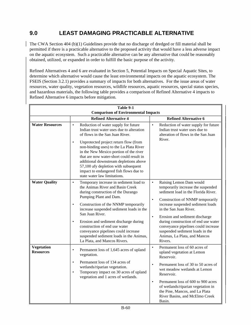
B-60
9.0 LEAST DAMAGING PRACTICABLE ALTERNATIVE
The CWA Section 404 (b)(1) Guidelines provide that no discharge of dredged or fill material shall be permitted if there is a practicable alternative to the proposed activity that would have a less adverse impact on the aquatic ecosystem. Such a practicable alternative can be any alternative that could be reasonably obtained, utilized, or expanded in order to fulfill the basic purpose of the activity.
Refined Alternatives 4 and 6 are evaluated in Section 5, Potential Impacts on Special Aquatic Sites, to determine which alternative would cause the least environmental impacts on the aquatic ecosystem. The FSEIS (Section 3.2.1) provides a summary of impacts for both alternatives. For the issue areas of water resources, water quality, vegetation resources, wildlife resources, aquatic resources, special status species, and hazardous materials, the following table provides a comparison of Refined Alternative 4 impacts to Refined Alternative 6 impacts before mitigation.
Table 9-1 Comparison of Environmental Impacts
Refined Alternative 4 Refined Alternative 6
Water Resources • Reduction of water supply for future Indian trust water uses due to alteration of flows in the San Juan River.
• Unprotected project return flow (from non-binding uses) to the La Plata River in the New Mexico portion of the river that are now water-short could result in additional downstream depletions above 57,100 afy depletion with subsequent impact to endangered fish flows due to state water law limitations.
• Reduction of water supply for future Indian trust water uses due to alteration of flows in the San Juan River.
Water Quality • Temporary increase in sediment load to the Animas River and Basin Creek during construction of the Durango Pumping Plant and Dam.
• Construction of the NNMP temporarily increase suspended sediment loads in the San Juan River.
• Erosion and sediment discharge during construction of end use water conveyance pipelines could increase suspended sediment loads in the Animas, La Plata, and Mancos Rivers.
• Raising Lemon Dam would temporarily increase the suspended sediment load in the Florida River.
• Construction of NNMP temporarily increase suspended sediment loads in the San Juan River.
• Erosion and sediment discharge during construction of end use water conveyance pipelines could increase suspended sediment loads in the Animas, La Plata, and Mancos Rivers.
Vegetation Resources • Permanent loss of 1,645 acres of upland
vegetation.
• Permanent loss of 134 acres of wetlands/riparian vegetation.
• Temporary impact on 30 acres of upland vegetation and 1 acres of wetlands.
• Permanent loss of 60 acres of upland vegetation at Lemon Reservoir.
• Permanent loss of 30 to 50 acres of wet meadow wetlands at Lemon Reservoir.
• Permanent loss of 600 to 900 acres of wetlands/riparian vegetation in the Pine, Mancos, and La Plata River Basins, and McElmo Creek Basin.

B-61
Table 9-1 (continued) Comparison of Environmental Impacts
Refined Alternative 4 Refined Alternative 6
Vegetation Resources (continued)
• Potential loss of 20 to 300 acres of wetland/riparian vegetation cover from construction of non-binding, water conveyance pipe lines.
• Potential loss of 20 to 300 acres of wetland/riparian vegetation cover from construction of non-binding, water conveyance pipelines.
Wildlife Resources • Direct loss (1,500 acres) and indirect loss of habitat value (1,200 to 1,400 acres) for upland wildlife.
• Direct loss of 134 acres of wetland
habitat. • Effects of intrusion, traffic and
recreation on nesting golden eagles and big game.
• Temporary effects of construction on
mule deer, elk and possibly elk calving areas.
• Loss of 20 to 300 acres of wetland
habitat through the construction of non-binding water conveyance structures.
• Direct loss of 30 to 50 acres of wetland habitat at Lemon Reservoir.
• Direct loss of 60 acres of upland
wildlife habitat. • Permanent loss of 600 to 900 acres
of wetland/riparian wildlife habitat in the Pine, La Plata, Mancos, Dolores River, and McElmo Creek Basins.
• Effects of bald eagle feeding and
osprey nesting. • Loss of 20 to 300 acres of wetland
habitat through the construction of non-binding water conveyance structures.
Aquatic Resources • Potential bioaccumulation of trace elements in Ridges Basin Reservoir.
• Reductions in fish habitat (decreases in
wetted perimeter and average depths) in the Animas River.
• Entrainment or impingement of native
fish on intake screens at Durango Pumping Plant.
• Creation of new lake habitat at Ridges Basin.
• Potential stranding of fingerling trout and native fish downstream of the Durango Pumping Plant.
• Competitive interaction between native fish and endangered species, and non-native fish escaping from Ridges Basin Reservoir.
• Reduction or extirpation of native fish habitat due to reduced flow in the La Plata River above the Colorado/New Mexico state line resulting from conversion of water from irrigation to M&I use.
• Potential inter-basin introduction of
white suckers from Lemon Reservoir to the Animas River and new introductions of this species to the La Plata River drainage.
• Potential impact of wetlands
conversion on fish in the Pine River (e.g., water quality, water temperature, and insect food base impacts).
Special Status Species
• Reduction or changes in bald eagle food base.
• Potential effect on southwestern willow flycatcher from construction of the NNMP.
• Potential effect on southwestern willow flycatcher from construction of the NNMP.
• Raising Lemon Dam could result in short-term construction-related disturbance to bald eagle roosting and feeding behavior.

B-62
Table 9-1 (continued) Comparison of Environmental Impacts
Refined Alternative 4 Refined Alternative 6
Special Status Species (continued)
• Potential effect of project operation on Colorado pikeminnow and razorback sucker in the San Juan River.
• Potential competitive interaction with
non-native fish released from Ridges Basin Reservoir to the Animas River.
• Conversion of wetlands and potential elimination of southwestern willow flycatcher and bald eagle habitat near surface waters in the Pine, La Plata, Mancos River, and McElmo Creek Basins.
Hazardous Materials
• Construction of the Durango Pumping Plant could expose contaminated materials.
• Hazardous materials used for the
construction of the Durango Pumping Plant and Ridges Basin Dam could cause stream pollution.
• Hazardous materials used for the construction at Lemon Dam could cause stream pollution.
The implementation of Refined Alternative 4 would result in the direct conversion of upland game habitat (1,500 acres) to a lake ecosystem that would provide aquatic and shoreline habitat for fish, waterfowl, and shorebirds. The loss of upland habitat would not eliminate big game use of the area. For example, elk migration corridors would not be totally replaced; however, these corridors would be narrowed and confined by the reservoir.
The reduction in physical habitat (chronic flow reductions) under Refined Alternative 4 would eventually reduce populations and/or biomass of native fish. The actual effect, however, cannot be specifically quantified without long-term monitoring. The degree of impact, although probably less than 15 percent, has been identified as significant because the resource impacted is indigenous to the river system. From a purely ecological perspective, impacts to native species are considered more significant than impacts to non-native species. Colorado native fish species are of an even higher concern because of the loss of habitat throughout the west.
Impacts of project pumping on native fish under Refined Alternative 4 would be difficult to quantify because: (1) dramatic changes in physical habitat would not occur, and (2) the inability to statistically enumerate or otherwise quantify the biomass of the native fishery that currently exists. Nevertheless, impacts to reproducing adult populations of native fish would occur much sooner to shorter-lived species, such as mottled sculpin and speckled dace, than longer-lived species. It would take a longer period to identify specific project effects on longer-lived species such as flannelmouth and bluehead sucker resulting from reductions in reproduction and recruitment. The impact of a reduction in usable habitat on adults, however, would be realized sooner.
There is a potential effect to native fish as well under Refined Alternative 6. The competitive interaction between native fish and white suckers because of inter-basin water transfer from Lemon Reservoir to the Animas River and the La Plata River is of concern. Long-term monitoring of the La Plata River would be needed to quantify this impact.
The potential effects on upland habitat and native fish were considered by Reclamation, with support from the Service and the State of Colorado. Refined Alternative 4 would restrict, but not eliminate, the upland migration corridors for big game. There would be some potential effects on one component of native fish habitat (wetted area), particularly in the lower Animas River (the last 0.5 mile) during August.
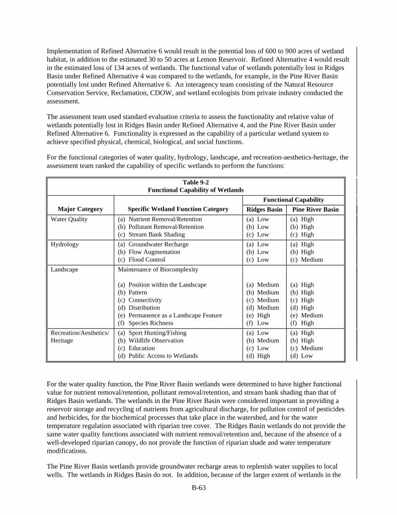
B-63
Implementation of Refined Alternative 6 would result in the potential loss of 600 to 900 acres of wetland habitat, in addition to the estimated 30 to 50 acres at Lemon Reservoir. Refined Alternative 4 would result in the estimated loss of 134 acres of wetlands. The functional value of wetlands potentially lost in Ridges Basin under Refined Alternative 4 was compared to the wetlands, for example, in the Pine River Basin potentially lost under Refined Alternative 6. An interagency team consisting of the Natural Resource Conservation Service, Reclamation, CDOW, and wetland ecologists from private industry conducted the assessment.
The assessment team used standard evaluation criteria to assess the functionality and relative value of wetlands potentially lost in Ridges Basin under Refined Alternative 4, and the Pine River Basin under Refined Alternative 6. Functionality is expressed as the capability of a particular wetland system to achieve specified physical, chemical, biological, and social functions.
For the functional categories of water quality, hydrology, landscape, and recreation-aesthetics-heritage, the assessment team ranked the capability of specific wetlands to perform the functions:
Table 9-2 Functional Capability of Wetlands
Functional Capability
Major Category Specific Wetland Function Category Ridges Basin Pine River Basin
Water Quality (a) Nutrient Removal/Retention (b) Pollutant Removal/Retention (c) Stream Bank Shading
(a) Low (b) Low (c) Low
(a) High (b) High (c) High
Hydrology (a) Groundwater Recharge (b) Flow Augmentation (c) Flood Control
(a) Low (b) Low (c) Low
(a) High (b) High (c) Medium
Landscape Maintenance of Biocomplexity (a) Position within the Landscape (b) Pattern (c) Connectivity (d) Distribution (e) Permanence as a Landscape Feature (f) Species Richness
(a) Medium (b) Medium (c) Medium (d) Medium (e) High (f) Low
(a) High (b) High (c) High (d) High (e) Medium (f) High
Recreation/Aesthetics/Heritage
(a) Sport Hunting/Fishing (b) Wildlife Observation (c) Education (d) Public Access to Wetlands
(a) Low (b) Medium (c) Low (d) High
(a) High (b) High (c) Medium (d) Low
For the water quality function, the Pine River Basin wetlands were determined to have higher functional value for nutrient removal/retention, pollutant removal/retention, and stream bank shading than that of Ridges Basin wetlands. The wetlands in the Pine River Basin were considered important in providing a reservoir storage and recycling of nutrients from agricultural discharge, for pollution control of pesticides and herbicides, for the biochemical processes that take place in the watershed, and for the water temperature regulation associated with riparian tree cover. The Ridges Basin wetlands do not provide the same water quality functions associated with nutrient removal/retention and, because of the absence of a well-developed riparian canopy, do not provide the function of riparian shade and water temperature modifications.
The Pine River Basin wetlands provide groundwater recharge areas to replenish water supplies to local wells. The wetlands in Ridges Basin do not. In addition, because of the larger extent of wetlands in the
B-64
Pine River system, the functional capacity for flow augmentation in the Pine River and flood control (reduction or control of flow velocity) is greater for these wetlands than that for Ridges Basin.
The assessment team based its evaluation of the landscape integrity function on such variables as:
• contiguity to nearby wetland areas • degree of wetland isolation • extent of existing disturbance • landform contrast • long-term stability • presence of open space or corridors • diversity of cover • species diversity, • wildlife access to other wetlands
Based on these variables, the team determined that the Pine River Basin wetlands have a greater probability of attaining the landscape integrity function because of its position in the landscape, and its broader distribution of wetland types dispersed between upland habitat and the riparian corridor of the Pine River. This position provides optimal connection to other wetlands and aquatic habitat and enhances the species richness of the area. The low rating for species richness in Ridges Basin is due primarily to the confined, disturbed condition of the wetlands, and the lack of structural diversity. An example is the lack of a well-developed wetland shrub and riparian canopy cover in Ridges Basin.
The assessment team determined that because of federal ownership and potential management capability, the Ridges Basin wetlands would have a higher protection status than that of the Pine Ridges Basin wetlands. This condition of land ownership and control also contributes to a higher rating for Ridges Basin under the "public access to wetlands" component of the recreation and aesthetics function. Private land ownership and restricted public access reduce this functional capability for the Pine River Basin wetlands and modifies the potential educational importance of these wetlands. Although public access is available to the Ridges Basin wetlands, the lack of species richness and the disturbed condition of the wetlands or the absence of optimal aquatic habitat does not provide optimal passive (educational) or consumptive (hunting or fishing) recreational opportunities.
Table 9-3 shows the team's assessment ranking of the wetland functional capabilities for variables considered important for wildlife and fish (e.g., pattern, size, contiguity, vegetation structure and diversity, and distribution relative to other wetlands).
The wildlife habitat value of wetlands to big game, primarily deer and elk, was assessed to be more important in the Pine River Basin than Ridges Basin. This higher ranking is based on the more optimal habitat conditions such as contiguity to nearby upland and wetland areas, diverse vegetation community structure (herb, shrub, and tree layer diversity), and broader pattern of wetlands in the Pine River Basin. The restricted public access to the Pine River Basin wetlands also contributes to the higher ranking. The land ownership and control issue, however, results in a lower ranking of Pine River Basin wetlands in the land use management function. Opportunities exist for management and protection of the federally controlled wetlands and state controlled upland habitat in Ridges Basin. No such opportunity exists on the privately owned land areas in the Pine River basin wetlands.

Table 9-3 Wildlife and Fish Habitat Functional Capability of Wetlands
Big Game Waterfowl Shorebird Amphibian-
Reptile Fish Neotropical
Bird Small Mammal
Threatened & Endangered
Species
Functional Category
Ridges Basin
Pine River Basin
Ridges Basin
Pine River Basin
Ridges Basin
Pine River Basin
Ridges Basin
Pine River Basin
Ridges Basin
Pine River Basin
Ridges Basin
Pine River Basin
Ridges Basin
Pine River Basin
Ridges Basin
Pine River Basin
Contiguity Medium High Low High Low High Low High N/A High Medium High Low High Low High
Vegetation Community Structure
Low High Low High Low Medium Low High N/A High Medium High Low High Low High
Vegetation Community Diversity
Low High Low Medium Low Medium Low High N/A High Medium High Low High Low High
Proximity to other Wetlands
Low High Low High Low Medium Low High N/A High Medium High Low High Low High
Land Use Management
High Low N/A Low N/A Low Low High N/A High Medium High Low High Low High
Wetland Size and Shape
Low High Low Medium Low Medium Low High N/A High Medium High Low High Low High
B-65

B-66
The team ranked the Pine River wetlands higher than the Ridges Basin wetlands in the capability to provide the wildlife habitat functions for small mammals and amphibian-reptiles. The relative reduced distribution and pattern of wetlands compared to upland habitat, and the limited suitability of existing habitat for wetlands-dependent species contributes to the lower functional ranking of the Ridges Basin wetlands.
The ranking of capabilities to achieve the functional values in the Pine River wetlands for waterfowl, shorebirds and fish were all ranked by the assessment team relatively higher than Ridges Basin wetlands. Waterfowl and shorebird habitat is poorly developed in the Ridges Basin wetlands, primarily because of the lack of water impoundment, pools, and ponds. Such areas exist in the Pine River wetlands, particularly near the river itself. Low depressions that seasonally are inundated in the Pine River wetland system also provide habitat values to waterfowl and shorebirds. The proximity of these areas to other wetlands provides seasonal connection to a series of inundated areas that are important for waterfowl migration. There are no fish that use the Ridges Basin wetland system, therefore the function is not applicable. There is a fishery, however, in the Pine River and the wetland system in that basin is important in maintaining water quality and control of pollutants, nutrients, and sediments. The water temperature control and insect food base for fish that is provided by the riparian canopy along the Pine River is also important.
The greater vegetation structural components (e.g., tree canopy, shrub layer, and vegetation cover) and the better connectivity to other wetlands along riparian and vegetated ditch corridors provide both habitat cover and the food base for neotropical birds in the Pine River wetlands. Although providing some habitat values, the reduced vegetation structural diversity, the relatively isolated pattern of wetlands compared to the surrounding upland habitat, and the smaller size and shape of the wetlands lowers the functional capability ranking for the Ridges Basin wetlands.
The Ridges Basin wetlands also ranked low in the functional capability to support threatened and endangered species. Of note would be the habitat support for the southwestern willow flycatcher and bald eagle. The optimal habitat condition provided by well-developed vegetation structure (multiple layer vegetation canopies) and diversity (tree and shrub types) is not present in the Ridges Basin wetlands. The Pine River wetland system; however, provides the habitat conditions for the willow flycatcher and the bald eagle. Reclamation staff has observed both willow flycatcher and bald eagles in the Pine River basin wetland complex. Willows and other shrubs and trees located near surface water are available for willow flycatchers in the Pine River Basin. Trees, near surface water, providing roosting habitat and feeding habitat are also available to bald eagles in the Pine River basin wetlands.
The Pine River Basin wetlands, an example of the wetlands potentially impacted under Refined Alternative 6, represent a large wetland complex rated high in the ability to meet water quality and hydrology functions. In addition, these wetlands have the capacity to provide habitat for two endangered species (southwestern willow flycatcher and bald eagle). Mitigation measures applied to Refined Alternative 6, outlined in the Chapter 3 of the FSEIS, Mitigation for Refined Alternative 6 Vegetation Impact 3, could reduce or avoid the potential impact to wetlands in the Pine, La Plata, and Mancos River, and McElmo Creek Basins. The Mitigation Policy ( 46 FR pages 7656-7663, 1981) outlines five types of actions that can be incorporated into mitigation recommendations. These five types of actions are to be considered in the following order: avoid the impact, minimize the impact, rectify the impact, reduce or eliminate the impact over time, and finally to compensate for the impact. Impact avoidance is a priority mitigation measure. Application of mitigation measures that follow an “avoidance, minimization, and compensation” sequencing is appropriate under the 1989 EPA and the Department of the Army Memorandum of Agreement (Mitigation MOA) (EPA 1989).
If the mitigation measure of avoidance is applied to the lands within the affected basins, it is assumed that under the best conditions, approximately 300 to 600 acres of wetland impacts potentially could be minimized or avoided. Minimization of impacts and/or avoidance could be attempted by allowing a

B-67
percentage of the consumptive use water acquired to remain on the land and thereby applied towards supporting the existing wetlands. The feasibility of this minimization/avoidance mitigation, however, is problematic. The portion of consumptive use water must be protected as “project water” with the expressed purpose of supporting wetlands. In addition, agreements, and perhaps easements, would be needed to protect the avoided wetlands. The feasibility of this wetland impact mitigation method would decline as the amount of wetlands to be avoided increases. Reclamation must also show that no harm would be caused to other water rights holders during this process while still acquiring sufficient land with water to meet the M&I requirements.
Even with the minimization/avoidance mitigation, there would remain a residual, unavoidable impact of 600 to 900 acres of wetlands. Applying the sequencing of mitigation, the available option is compensation. This compensation mitigation would involve a large program of water and land acquisition from willing sellers to provide the elements needed to create replacement wetlands. The mitigation ratio and the lands required for compensation would vary depending on the type of requirement negotiated with federal agencies. The mitigation ratios approved by EPA, the Service, and other agencies typically are: 3:1 for enhancement, 2:1 for creation, 1.5:1 for hydrologic restoration, and 1:1 for physical restoration. The ratios are negotiated on a case-by case basis. Based on the range of ratios, to mitigate for the loss of 600 acres of wetlands, it is expected that a range of 600 acres to 1,800 acres of wetland compensation would be required.
Even when considering the application of the minimization/avoidance mitigation measure, Refined Alternative 6 would still affect some 600 to 900 acres of wetland and potential endangered species habitat. In its Planning Aid Memorandum, the Service ranked all project alternatives, including Alternatives 4 and 6, along with their potential impact to the environment (Service 1999). The rankings addressed impacts on wildlife, riparian wetlands, aquatic resources, and federally listed threatened and endangered species. The Service ranked refined Alternative 6 lower than Refined Alternative 4, chiefly because of the potential effects to wetlands and endangered species habitat. The Service’s conclusion is that the cumulative impacts of combined structural and non-structural elements proposed in the Pine River drainage, for example, would likely exceed impacts of a Ridges Basin Reservoir alternative.
Wetlands are diminishing resources worthy of protection and management under the CWA, Executive Order 11990 (Protection of Wetlands), and the ESA. Comparing the potential impact on upland habitat and the impact to native fish (albeit uncertain) under Refined Alternative 4, and the overall potential impacts to wetlands, native fisheries, wildlife, and associated endangered species under Refined Alternative 6, Reclamation has determined that Refined Alternative 4 would be the least damaging practicable alternative.

B-68
10.0 FACTUAL DETERMINATIONS (230.11)
10.1 Physical Substrate Determinations
IMPACT 1: Loss of hydric or aquatic substrates.
Refined Alternative 4 would cause the permanent loss of 134 acres of potentially hydric or aquatic substrates occurring in the Ridges Basin Reservoir site and in Basin Creek. Additionally, hydric/aquatic substrates would be indirectly affected by changes to flow regimes and related fluvial processes in the Animas River. Substrate impacts in Basin Creek would reduce the potential for seedling colonization by wetland and riparian species and survival of sapling riparian trees.
Mitigation Actions: Reclamation has proposed bypass flows at the Durango Pumping Plant which are designed to maintain bypass flow levels that would minimize potential impacts to riparian/wetland recruitment, channel maintenance, and native fish populations. To further reduce the significance of the impact to Basin Creek channel wetlands and riparian vegetation, Reclamation has selected a means of erosion and siltation controls that use a series of check and drop, or vortex weirs. The implementation of these controls would produce an increase in silt transport initially but would stabilize with use. Some wetlands could be created over time. The creek bed would be realigned into gentle curves and graded to create relatively flat slopes. The checks across the creek bed would be about 60 feet wide, with a depressed 10-foot wide weir in the center. A damp area approximately 50 feet wide by 2.5 miles or longer could provide about 15 acres of wetland development.
These actions would minimize, but not completely avoid, significant impacts. Therefore, Reclamation has also proposed off-site wetland mitigation plans (see Section 10.5) that would restore and enhance hydric and aquatic substrates in candidate areas near Ridges Basin. The wetland mitigation, if implemented, would provide full replacement of wetlands, and associated substrate habitats, unavoidably impacted by Refined Alternative 4.
IMPACT 2: Temporary disruption of hydric and streambed substrates.
Approximately 12 linear miles of wetland/riparian vegetation would be crossed by the non-binding water conveyance pipelines resulting in temporary disruption of approximately 20 to 300 acres of substrates subject to potential hydric or aquic soil moisture conditions, as well as other streambed substrates. The actual width and alignment of the pipelines would determine the ultimate impact. The Ridges Basin Inlet Conduit would cross approximately 0.1 acre of intermittent drainage.
Mitigation Actions: A series of avoidance actions would be routinely implemented to minimize trenching into substrates that support wetland/riparian vegetation (Sections 7.1 and 7.2). Where such disturbance is unavoidable, trenches would be restored across drainages so that native substrate profiles and contours would be re-established (Section 7.2). These actions should prevent long-term adverse effects to substrates.
10.2 Water Circulation and Fluctuation Determinations
IMPACT 3: Reduction of flow in the Animas River.
The operation of the Durango Pumping Plant will chronically reduce native fish populations and associated habitat. The effect is believed to be relatively small (less than 10 percent). Reductions in flows that correlate to significant decreases in wetted perimeter and average depths could impact native fishes in the Animas River. The section of the Animas River that would be most impacted by project flows is from Aztec, New Mexico, downstream to the confluence with the San Juan River. This section of the river is
B-69
subject to the lowest flows under existing conditions. These low flows routinely occur each year and may be one reason for the low abundance of native fish in this section of the river.
The analysis in the FSEIS indicate that average depth in riffles and runs is expected to decrease 51 and 44 percent, respectively, in some months over that of the No Action baseline conditions. Wetted perimeter is also expected to decrease in dry years by 30 and 36 percent for riffles and runs, respectively. These decreases in wetted perimeter and average depth impact adult native fish by:
q Reducing available food through the dewatering of productive riffles and edge of channel areas.
q Providing greater risk of disease through increased environmental stress based upon elevated water temperatures in dry water years.
q Concentrating adult fish in the remaining suitable habitats.
q Reducing the ability of fish to navigate shallow riffles.
Small native fish species, such as the mottled sculpin and speckled dace, as well as young individuals of the larger native fishes, would be significantly impacted by a physical reduction in habitat. These small fish occupy riffles and low-velocity, shallow edge habitats, which are most sensitive to reductions in flow.
This impact cannot be effectively mitigated in the Animas River. Therefore, it is recommended that appropriate mitigation be applied to another river within the San Juan River Basin, one that has a similar native fish composition as the Animas River.
Mitigation Actions: Reclamation will continue to monitor native fisheries in the Animas River and will evaluate several methods of compensation for impacts, including modifying pumping operation, providing fish passage around migration barriers on the Animas River, and providing and protecting ALP Project water in the La Plata River. At a minimum, these studies would commence in 2000 and would incorporate these additional elements into the monitoring study currently being conducted on the Animas River. A firm recommendation for mitigation would be made by no later than 2005, at least two years prior to project pumping from the Animas River. Investigations would be initiated to determine whether or not fish passage barriers and dewatering in late summer are impacting the native fish populations. If a significant impact is occurring, Reclamation would investigate the possibility of providing complete passage of fish within sections of the Animas River currently allowing free passage of fish and providing suitable flows to maintain fish habitat requirements. (See Section 5.4.6 of the FSEIS for further information.)
If the results of the monitoring program indicate that the operation of the Durango Pumping Plant is having significant adverse effects on downstream native fish populations, Reclamation would make every reasonable effort to modify ALP Project operations to either reduce or eliminate these impacts. Current fishery studies for the La Plata River indicate the presence of native fish within limited and degraded habitat. The La Plata River is a good candidate for increasing flows to protect existing habitat, and potentially enhance and expand the habitat for native fish.
Of all the rivers within the basin, the La Plata River native fish population is the most jeopardized. This is due primarily to extreme flow depletions and man-caused effects on stream geomorphology. The La Plata River from Cherry Creek downstream to the Colorado-New Mexico state line currently supports a fish community that is nearly 100 percent native fish, including roundtail chub. This section of river also has low base flows during the summer due to irrigation diversions. Additional flow in this section of the river during the summer would enhance habitat for the native fish community. This increase in flow would require protection from diversions to be a viable mitigation alternative. The increased streamflow would be

B-70
consistent with the other mitigation proposed along the La Plata River for wetlands/riparian and wildlife resources.
In addition, conservation easements would be pursued with other landowners in the La Plata River valley, those with lands within the section of perennial flow between the confluence of Cherry Creek to approximately two miles south of the Colorado/New Mexico state line. If acquired, these conservation easements would effectively protect important native fish habitat, particularly habitat for the roundtail chub.
IMPACT 4: Reduction of flows in the San Juan River for Indian Trust water use.
A small impact (80,700 afy or 2 percent of total flow) ) of Refined Alternative 4 on flows in the San Juan River would be between its confluence with the Animas and La Plata rivers. In this short stretch of river, the minimum SJRBRIP flow requirements for endangered fish would be met. The presently defined operating rules and hydrology model configuration used for assessing the impacts of water development on the ability to meet the SJRBRIP flow recommendations do not indicate availability for substantial additional depletions in the basin with the present flow recommendations.
For the baseline condition, only 20,000 of the 62,420 afy of depletion required can be delivered. With Refined Alternative 4, present model results indicate no further allowable development, result in an impact to Indian trust water development of 20,000 afy. The impact is based upon the use of modified recommended operating rules for Navajo Dam to mimic a natural hydrograph for the benefit of endangered fish in the San Juan River. With additional model refinement and improved operation rules, this impact may be less.
Mitigation Actions: Work is continuing to refine the San Juan River Basin hydrology model and improve operating rules to meet flow recommendations and provide for water development. Other elements of mitigation not dealing directly with hydrology or modeling are listed under Indian Trust Assets. Since the water required to meet this demand is inadequate even without the project, the impacts of this alternative are incremental to the total impact. Since water remains limiting, the impact remains potential significant..
IMPACT 5: Flow augmentation in the La Plata River
Project return flow from non-binding uses would increase flows in the La Plata River, New Mexico within a portion of the river that is now water short. It is assumed that these return flows would enter at the Colorado/New Mexico state line. The flows in this reach of the river would be enhanced by about 15,500 afy. Unless these return flows are protected or the depletion of them replaced, downstream depletion will increase above 57,100 afy with subsequent impact to endangered fish flows. The La Plata River would be impacted from the Colorado/New Mexico state line to the confluence with the San Juan River.
Mitigation Actions: Reclamation will commit to work with all appropriate State and Federal agencies to pursue a method to protect return flow waters in the La Plata Drainage as a water supply for endangered fish. Currently this ESA water cannot be identified as a project purpose and as project waters. All means will be taken to protect this water for the life of the ALP Project. Alternately, any depletion of these return flow water volumes will be included within the annual average depletion of 57,100 afy for the ALP Project.
Projected return flows to the La Plata River would enhance flows in the reaches of the river where shortages to irrigation users are common. As a practical matter, it is unlikely that these return flows can be protected and passed downstream during water short months. The uses of these return flows by downstream irrigators during water short periods become depletions incidental to the ALP Project. To prevent exceeding the total ALP Project depletion of 57,100 afy, project uses would be reduced by the amount of incidental depletion resulting from the return flow use.
B-71
10.3 Suspended Particulate Materials and Turbidity Determinations
IMPACT 6: Short-term suspended sediment load increases in Basin Creek, and the Animas, San Juan, La Plata, and Mancos Rivers.
Construction of the proposed Durango Pumping Plant and its intake bays would temporarily disturb the bank material, which could increase the suspended load in the Animas River. In addition, groundwater removed during construction dewatering would need disposal. Based on existing data and anticipated dewatering rates, discharge is not expected to exceed the limits of any regulated parameter (Reclamation 1996). However, if the dewatering rates are higher or the water quality lower, treatment of the groundwater may be needed prior to discharge.
Construction of Ridges Basin Dam, Reservoir, and outlet structures and stabilization of the stream channel could temporarily increase the suspended sediment loads in Basin Creek and subsequently in the Animas River. The channel regrading and stabilization should prevent an increased sediment load to the Animas Rover after initial stabilization with no significant impact during operation.
Installation of siphons across the San Juan River at Farmington and near Shiprock for the NNMP, and the Animas, La Plata, and Mancos Rivers and minor tributaries for the non-binding pipelines, could temporarily increase the suspended sediment loads contributed by soil disturbing activities and bank erosion.
Mitigation Actions: A program would be implemented to reduce or eliminate temporary, short-term increases in suspended sediment loading or other water quality constituents, potentially caused by project construction, through the incorporation of permits, BMPs, and sediment control structures. Sections 7.1 and 7.2 describe a range of avoidance and minimization measures that would be used routinely during and after construction. These measures would reduce the impact to a less than significant level.
10.4 Contaminant Determinations
IMPACT 7: Release of contaminated water from the construction of the Durango Pumping Plant to the Animas River.
The construction of the Durango Pumping Plant and its intake channel would involve excavations at the UMTRA remediation site. Soils excavated for the pumping plant foundation and inlet channel would be distributed and contoured on the site. There is a potential for the exposure of soil and water previously contaminated by hazardous waste during the construction of the pumping plant. The release of contaminated water to the Animas River could pose a health hazard to people and the aquatic ecosystem. The excavation and re-deposition of contaminated soil could expose construction workers to radioactivity and result in contaminated soil being left at the surface of spoil areas when construction is complete.
The foundation excavation could also encounter contaminated groundwater and allow it to discharge into the foundation excavations. Water pumped from the excavations for dewatering, which under other circumstances might be desilted and released to the river, would need to be monitored for contamination and, if contamination is identified, be run through a treatment process prior to release from the site.
Mitigation Actions: The Durango Pumping Plant and intake channel would be designed to minimize the disturbance of contaminated materials. Procedures will be developed for radiological testing and monitoring at the construction site of the pumping plant and intake structure. If, after soil testing, it is determined by Reclamation that potential discharge of radiological contaminants to waters of the United States could result from site construction activities, site designs would be altered to preclude the discharge. Such changes in site plans, and location of the intake structure would be evaluated as to effectiveness in minimizing or reducing potential impacts. Procedures would also be developed for radiological monitoring

B-72
of excavated soils and groundwater encountered, and remedial procedures would be planned in advance to eliminate the potential for human exposure and release of contaminated groundwater from the construction site. If the excavation were to encounter soils that still contain contamination, they would be segregated and stockpiled separately, and then disposed of at a suitable disposal site.
A requirement of the pumping plant design would be to prevent contaminated groundwater from entering the pumping plant and impacting water quality in Ridges Basin Reservoir. The design of the pumping plant, intake channel and intake structure would employ construction materials and design techniques that would result in an installation that eliminates the infiltration of groundwater. The pumping plant foundation and understory walls could be designed to provide the necessary shielding against any remaining hazard from groundwater or soil contamination at the site, as well as to prevent infiltration of groundwater. A principal requirement of the construction program would be safe handling of soil and water contamination encountered during construction, to prevent adverse impacts to public health and the environment. A set of minimum construction requirements have been developed (Reclamation 1995).
The human exposure to contaminated soils and the potential for release of contaminated groundwater from the site would be mitigated by measures that include the following:
q Reviewing remediation reports and current monitoring data to understand existing subsurface conditions with respect to radioactive materials.
q Obtaining pre-construction soil and water samples at the pumping plant and intake channel site for laboratory testing of radioactive constituents.
q Developing a Site Safety and Health Management Plan, including radiation protection for workers and the public.
q Developing construction plans to deal with the potential hazardous conditions of excavated soils and groundwater.
q Using analytical data to design a treatment system for the contaminated water from de-watering activities during construction.
q Providing a treatment system, if needed, to decontaminate water pumped from excavations before discharge to the river, under permit conditions required by the Colorado Discharge Permit System (CDPS).
During the design phase of the ALP Project, the additional subsurface testing performed for the project, and the resulting pumping plant design and construction management plan would be presented to EPA and state regulatory agencies for approval.
IMPACT 8: Hazardous materials used for the construction of the Durango Pumping Plant and Ridges Basin Dam could cause stream pollution.
Various hazardous materials ranging from paints to industrial solvents would be used in the construction of project features. If carelessly disposed of, their containers or application tools could introduce contaminants to the Animas River or Basin Creek. Typically, standard construction specifications contain handling and disposal procedures to prevent such contamination.
Mitigation Actions: Reclamation will commit to following all federal and state requirements pertaining to the management and handling of hazardous materials mixed waste and radioactive waste, and include those requirements within construction contract language inclusive of construction safety and environmental compliance. Specific requirements for handling hazardous materials and disposal of

B-73
containers and contaminated materials and scrap would be written into construction specifications. Contractors will be required to dispose of such materials in approved disposal areas.
10.5 Aquatic Ecosystem and Organism Determinations
IMPACT 9: Reservoir bioaccumulation of trace elements.
The Animas River transports several trace elements that could, under certain conditions, contribute to elevated levels within the food chain. Mercury and selenium are of particular concern. The quality of the water pumped from the Animas River to Ridges Basin Reservoir would determine the potential magnitude of this impact. Depending on the severity of bioaccumulation, fish and wildlife resources could be adversely impacted. The degree to which trace elements can be bioaccumulated, if at all, is difficult to predict.
Mitigation Actions: Reclamation commits to conducting a monitoring program at Ridges Basin Reservoir to measure the extent of bioaccumulation of trace elements in associated fish and wildlife. This monitoring program will be initiated within two years after the reservoir is filled. The monitoring study will be conducted annually for a minimum of four years. The monitoring program would include sample collection of reservoir water, sediment, and associated fish and wildlife species. As possible, fish and wildlife samples would be collected. If a significant bioaccumulation effect were identified, Reclamation would commit to work with the appropriate local, state, and federal entities to attempt to minimize the impact.
IMPACT 10: Permanent loss of wetland/riparian habitats from reservoir inundation and dam construction.
Construction of Ridges Basin Reservoir and Dam would result in a permanent loss of 121 acres of riparian/wetlands. Approximately 5 acres of riparian/wetlands would be lost at the proposed dam site and immediately downstream of the dam. Another estimated 8 acres of riparian vegetation would be lost along Basin Creek below the proposed dam site to the confluence with the Animas River as a result of channel stabilization.
Mitigation Actions: Reclamation would replace the 134 acres of wetland/riparian vegetation under one or more of several mitigation options, as described in Attachment B-2 in Volume 2 of the FSEIS. Sufficient acres of wetlands would be created, restored, preserved and/or enhanced under several options for wetland mitigation identified which would allow Reclamation to meet wetland mitigation goals. Mitigation ratios would vary from 1:1 for restoration, 2:1 for creation, and 3:1 for enhancement and preservation. Included in these options are the creation of 115 acres of wetlands at Ridges Basin. The mitigation will involve a program of land acquisition, wetland development, and long-term management. To the extent possible, this program would be integrated into the wildlife habitat mitigation program to expand benefits and provide large blocks of contiguous wildlife habitat. The actual amount of land needed to create this amount of wetlands depends on topography, soils, and water availability on lands acquired. Because of limited water supplies for new wetland creation in the region, restoration of degraded wetlands would be an important component of any wetland plan.
After Ridges Basin mitigation, the La Plata River Basin would be given first priority for wetland development; however, lands would be acquired on a willing seller basis so the exact location cannot be determined at this time. The location, topography, presence of waterways, and water supply on the land acquired would dictate the feasibility and type of wetland development undertaken.
Potential measures to restore wetland and riparian areas and their value include grazing control, instream structures, individual plantings, reestablishing meandering channels, and providing water to upper terraces.

B-74
Up to 268 acres of lost or damaged wetlands could be restored to a naturally functioning ecosystem within the La Plata Basin.
Creation of new wetlands on uplands would require importing water or using existing water rights on the property acquired. Importing water from Ridges Basin, while expensive, is a future possibility if multiple needs could be met.
Lands for wetland mitigation will be acquired prior to award of the Ridges Basin Dam construction contract and physical features of the wetland development will be at least 95 percent complete prior to starting reservoir filling. Plans would be designed in cooperation with the Service and EPA.
To further reduce the significance of the impact to Basin Creek channel wetlands and riparian vegetation, Reclamation has selected a means of erosion and siltation controls that use a series of check and drop, or vortex weirs. The implementation of these controls would increase silt transport initially but would stabilize with use. Some wetlands could be created over time. The creek bed would be realigned into gentle curves and graded to create relatively flat slopes. The checks across the creek bed would be about 60 feet wide, with a depressed 10-foot wide weir in the center. A damp area approximately 50 feet wide by 2.5 miles or longer could provide about 10 to 15 acres of wetland development.
IMPACT 11: Loss of wetland/riparian areas caused by pipeline construction.
Gas pipeline construction along alignments that cross small creeks and drainage courses could impact small areas of riparian/wetland vegetation. Such loss of vegetation would depend on the alignment chosen by Reclamation. Potential impacts to wetland/riparian vegetation could result from trenching, earth moving, and standard construction activities. Depending on the extent and type of vegetation cover, such impacts may be either temporary or permanent. The impact to wetland/riparian vegetation during the construction of the gas pipeline at the crossings of the Animas River, however, is expected to be minimal if directional drilling is used.
Construction of water conveyance pipelines for the non-binding water end uses could result in the loss of between 20 and 300 acres of wetland/riparian vegetation. The actual loss would depend on the width and alignment of the construction corridor. Losses would result from trenching, earth stockpiling, equipment staging, and pipe storage laydown, all activities that are typically associated with pipeline construction.
Mitigation Actions: Pipeline siting would be planned to avoid or minimize the crossing of significant wetlands or riparian vegetation cover. Whenever possible, directional boring would be employed to minimize the impact to wetlands/riparian vegetation along the Animas and the La Plata Rivers, and other major watercourses. BMPs and a restoration plan for impacts to vegetation will be developed and monitored. All sensitive areas (extensive areas of trees, emergent wetlands, and open water) would be flagged during construction to prevent the accidental encroachment of construction equipment.
If impacts to wetlands/riparian vegetation cannot be avoided, a vegetation mitigation plan will be developed to compensate for the loss of vegetation cover. This plan will be developed in consultation with the Service, CDOW, and other agencies. The mitigation plan will contain a long-term monitoring program to ensure the success of the mitigation plan to fully compensate for the loss of vegetation cover.
IMPACT 12: Southwestern willow flycatcher interference.
Construction of the NNMP impact southwestern willow flycatcher nesting habitat at two crossings of the San Juan River. The southwestern willow flycatcher is known to nest in willows and other trees with a cottonwood overstory along rivers. Based on habitat structure, dense stands of Russian olive and tamarisk vegetation also provide the cover requirements for preferred willow flycatcher nest sites. The species occupies nest sites between about mid- May to about August. Willow flycatchers overwinter in Mexico,

B-75
Central America, and possibly South America, and the species begins to migrate during late fall to these areas. Surveys conducted in October 1999 at the location of the proposed San Juan River crossing of the NNMP determined that flycatcher habitat would not be adversely affected during construction and operation of the pipeline. However, construction noise or physical disturbance of nest sites during the critical mid-May through August nesting period may adversely affect flycatcher breeding success.
Mitigation Actions: The construction of pipeline crossings will be scheduled during the September to May period, outside of the nesting season of the southwestern willow flycatcher.
IMPACT 13: Effect on Colorado pikeminnow and razorback sucker populations and critical habitat.
As discussed in Section 4.1, the proposed flow depletions under Refined Alternative 4 without offsetting measures may affect the Colorado pikeminnow and razorback sucker in the San Juan River. In the Biological Opinion (Service 2000a), it was concluded that the project would not jeopardize the continued existence of the Colorado pikeminnow or razorback sucker, and the proposed project would not likely destroy or adversely modify critical habitat.
Mitigation Actions: The ALP Project’s proposed 57,100 afy of depletion meets the requirements of the 2000 Biological Opinion (see Section 7.3). The ALP Project includes the commitment to operate Durango Pumping Plant so that the flow recommendations for the San Juan River, which should benefit endangered fish and their critical habitat, can be met. Reclamation has also committed to operate Navajo Reservoir to mimic a natural hydrograph. Under this alternative, there should be no significant impact to either endangered fish species due to flow reductions.
IMPACT 14: Competitive interaction between non-native fish and endangered fish in the San Juan River.
A possible impact to the endangered fish in the San Juan River is the interaction with non-native fish species escaping from Ridges Basin Reservoir. The proposed stocking of trout in Ridges Basin Reservoir poses no threat to either the Colorado pikeminnow or razorback sucker in the San Juan River. However, the possibility does exist that other non-native species, which may compete with native fish populations in the Animas and San Juan Rivers, may be illegally stocked into the reservoir and subsequently escape to the Animas River and ultimately reach the San Juan River. Because the majority of reservoirs in the area have received illegal stockings of non-native species, it is assumed that Ridges Basin Reservoir will also.
Mitigation Actions: The reservoir outlet system will be designed and fitted with devices to eliminate survival of fish escaping the reservoir. The release of all flows through a pressure dissipation valve is an example of such a device. The change in pressure should result in nearly 100 percent mortality of any fish that escape through the outlet works. To augment the effectiveness of this system, designing dam outlet structures to take water from deeper water zones within the reservoir could further prevent fish escapement from Ridges Basin Reservoir. The dam outlets would be located as deep in the reservoir as possible to draw primarily anoxic, hypolimnetic water. The hypolimnion zone is likely to be devoid of fish in summer and winter. Reclamation will monitor escapement from the reservoir and Basin Creek.
10.6 Proposed Disposal Site Determinations
Substrate materials excavated from the ALP Project area could be used as fill materials for various project features. Additionally, fill material could be brought into the site from local quarries. The following is a summary of fill disposal sites and materials to be used:
q Ridges Basin Dam and Related Fill Areas. Embankment materials coming from Borrow Area A (within Ridges Basin) for the dam would be similar to valley alluvium, the existing

B-76
streambed and riparian substrates. Impervious fill materials would consist of the largely clayey deposits taken from the reservoir basin borrow area. Pervious fill would be obtained from Borrow Area B, gravel deposits in an existing quarry, located on an upland terrace along lower Basin Creek. Waste material excavated for the dam foundation would be deposited into the reservoir basin atop the existing substrate or deposited into Basin Creek drainage as wetland construction fill. The deposited material would consist of alluvium similar to the reservoir basin and Basin Creek alluvium, but would also consist of slopewash and angular sandstone and siltstone blocks not necessarily found in the existing substrate of the reservoir basin.
q Cofferdams and Temporary Diversionary Structures. A cofferdam would be used in the Animas River for construction of the Durango Pumping Plant, and a cofferdam is an option allowed the contractor for construction of Ridges Basin Dam on Basin Creek. Cofferdams may be placed in the San Juan River and other drainages containing surface flow, as needed for construction of pipeline and canal siphon crossings. Fill materials would consist of the unconsolidated sand, silt and clay deposits derived from local sources.
10.7 Determination of Cumulative Impacts on the Aquatic Ecosystem
Section 230.11(g) of the 404(b)(1) Guidelines defines cumulative impacts as the changes attributable to the collective effects of a number of individual discharges to an aquatic ecosystem. The following projects may have cumulative impacts when taken in conjunction with the completion of the ALP Project.
q Operation of Navajo Dam. The operation of Navajo Dam to meet the SJRBRIP flow recommendations provides the mechanism that allows project development to continue in the San Juan River Basin. In 1991, the status of endangered fish in the San Juan River stopped additional depletions in the river. The commitment to operate Navajo Dam to mimic a natural hydrograph allowed 57,100 afy of depletion associated with Phase I, Stage A of ALP to proceed. The subsequent flow recommendations issued by the SJRBRIP in 1999 set the requirement for water to meet the needs of endangered fish. Extensive hydrology modeling demonstrated that there was sufficient water in the basin to allow the 57,100 afy depletion for the ALP Project and an additional depletion amount in excess of 122,000 but less than 210,000 afy. The actual amount available would depend on the nature of the development and the reservoir operating rules employed.
While this operating scenario allowed for further development of water in the San Juan River Basin, it also set the limit of developable water at a level less than full entitlement under the Upper Colorado River Compact.
q Navajo Indian Irrigation Project. The completion of the Navajo Indian Irrigation Project (NIIP) will increase annual depletions on the San Juan River by about 120,580 afy under equilibrium conditions, and by about 137,580 afy until return flows reach the equilibrium, level approved for the ALP Project. The 1999 Biological Assessment and letter of concurrence from the Service allowed construction to proceed up to the full level of development, utilizing a large portion of the remaining developable water within the flow recommendation.
q Future Indian Water Development. The completion of the ALP Project and NIIP, in conjunction with the requirement to meet the flow recommendations for endangered fish, limits the available water supply for future development. The three Indian projects identified for future development (Jicarilla Water Rights Settlement, Navajo-Gallup Water Supply Project, and completion of the Hogback Project) have a total average depletion of about 69,800 afy. With the no action alternative, 20,000 afy of demand can be met without changing operating rules for Navajo Dam. For Refined Alternative 4, current modeling does

B-77
not indicate any additional water available while meeting the flow recommendations as they now stand.
Since the flow recommendations may change in the future, under adaptive management and modified operating rules, the flow recommendations may be met with less water released from Navajo Dam. With more efficient operation, therefore, the impacts above may be less in the future.
10.8 Determination of Secondary Effects on the Aquatic Ecosystem
Secondary effects (e.g., fluctuations in water levels, changes to fluvial dynamics, increased return flows) are treated extensively in Sections 3 through 7. The proposed ALP Project, under Refined Alternative 4, would not be expected to cause other secondary effects.

B-78
11.0 STATUTORY REQUIREMENTS (230.10(B))
Section 404(r) of the CWA provides an exemption from permitting for federal construction projects specifically authorized by Congress if:
"...information on the effects of such discharge, including consideration of the guidelines developed under subsection (10)(b) of this section, is included in an environmental impact statement for such project ... submitted to Congress before the actual discharge of dredged or fill material in connection with the construction of such project or appropriation of funds for such construction."
Thus, the 404(r) exemption relieves certain Federal projects from the requirement of submitting a separate permit to the Army Corps of Engineers (Corps), but does not relieve the lead agency from the environmental compliance process as specified in the 404(b)(1) Guidelines. The primary purpose of the exemption process is to eliminate the need for separate submittals to both the Corps and Congress. While the potential for a veto of a project permit by the EPA under its 404(c) authority is eliminated under the 404(r) exemption, the 404(r) guidelines clearly state that the proponent agency must include written comments from the EPA and Corps on the adequacy of compliance with the (b)(1) guidelines with the submission of the environmental documents to Congress. Congress, in a sense, assumes the 404 role of the Corps and EPA but does so with the guidance of these two agencies. The EPA guidelines for Subpart B apply to the ALP Project, but in the context of 404(r).
Subpart B of the Guidelines requires that "no discharge of dredge or fill material shall be permitted if it "causes or contributes" to violation of any applicable State water quality standard, or any applicable toxic effluent standards, the Endangered Species Act, or Title 3 of the Marine Protection, Research, and Sanctuaries Act of 1972.
11.1 State Water Quality Standards
Although a formal water quality certification pursuant to Section 401 of the CWA is not required under 404(r), consultation with the states of Colorado and New Mexico is ongoing. The State of Colorado has indicated that no significant conflicts with state water quality standards are expected, but would not make a final decision until completion of review of the FSEIS and 404(b)(1) Alternatives Analysis. The State of New Mexico has indicated that no decision on consistency with state water quality standards can be made until the FSEIS and 404(b)(1) Alternatives Analysis are reviewed. Studies completed by Reclamation indicate that operation of the ALP Project in conjunction with the proposed mitigation activities would not cause any significant change in water quality.
Additional water quality studies of pre-project conditions undertaken by Reclamation (Reclamation 1996) supported earlier water quality studies conducted for the 1980 FES, the Definite Plan Report (Reclamation 1979), and the 1992 Draft Supplement to the FES (Reclamation 1992). These additional studies of existing water quality in the Animas and La Plata River Basins in Colorado and New Mexico, as well as the Mancos River Basin in Colorado, found that chronic water quality standards and acute water quality standards were exceeded by one or more of the dissolved metals. The number of incidents and the degree of concentration in excess of standards depend in large part on the location in the watershed and other factors. For example, in the upper reaches of the Animas River Basin, all but the total Mn standard has been exceeded, but the number of times that the various standards are exceeded decreases downstream, and exceedences are at their lowest downstream from the pumping plant site at Durango. The concentrations of As, Zn, and Cu do not exceed the water quality standards in any samples at the furthest station downstream near Aztec.

B-79
Selenium has been identified as a constituent of concern. Reclamation concludes that overall loadings would be reduced with the operation of the ALP Project. Specifically, Ridges Basin Reservoir would remove some of the selenium loading. Also, the pre- and post-project differences in concentrations are minimal.
These conclusions suggest that the ALP Project would not cause a measurable adverse impact on water quality in New Mexico or in Colorado.
With respect to the construction of the Durango Pumping Plant, Reclamation or its contractor would apply for a NPDES Permit. Reclamation or the contractor for Durango Pumping Plant would be required to secure a discharge permit from the appropriate regulatory entity in the Colorado Department of Health for construction activities at the site. In addition, because the site is a former UMTRA site, regular monitoring of the water removed during dewatering operations would be required. Also, Reclamation would require the contractor to prepare and implement, if necessary, a contingency plan for treating the water removed during excavation in the event that groundwater contamination levels exceed anticipated limits.
11.2 Toxic Effluent Standards
Toxic effluent standards deal with pretreatment requirements for discharge to publicly owned treatment works and, therefore, is not applicable to the proposed ALP Project.
11.3 Endangered Species Act
Section 230.10(b)(3) prohibits the issuance of a permit for discharge of fill into waters of the United States, if the discharge would cause jeopardy to any federally listed threatened or endangered specie. In 1999, the Service provided a list of endangered, threatened, and candidate species for evaluation. The following threatened or endangered species listed included:
Animals
§ Colorado pikeminnow § Razorback sucker § Bald eagle § Southwestern willow flycatcher § Mexican spotted owl § Black-footed ferret § Canada lynx § Mountain plover § Boreal toad
Plants
§ Knowlton’s cactus § Mancos milkvetch § Mesa Verde cactus § Sleeping Ute milkvetch
Of the species listed for evaluation, the Service concluded in the 2000 final Biological Opinion that the ALP Project would affect but not jeopardize the continued existence of the Colorado pikeminnow and razorback sucker and would not adversely impact their designated critical habitat in the San Juan River. The ALP Project would not likely jeopardize the continued existence of the other species.

B-80
Revised Alternative 4 would comply with the provisions of Section 230.10(b)(3) in that it would meet with the depletion limit set in the Biological Opinion.
The 2000 Biological Opinion is based upon best scientific and commercial data. Under the ESA, formal Section 7 consultation shall be re-initiated if new information becomes available. In such a consultation, the relationship between the flow recommendations needed to implement the ESA, the operation of Navajo Dam, existing and future depletions, and the effects of the ALP Project, will all have to be evaluated. If a positive population response is not achieved under the existing flow recommendations, or if future Navajo Reservoir operations do not implement the flow recommendations, the ALP Project and all existing depletions, as well as those future depletions that have received approval from the FWS will be subject to re-initiation of consultation under Section 7.
11.4 Marine Sanctuaries
There are no marine sanctuaries in the ALP Project area; therefore, this section does not apply.

B-81
12.0 SIGNIFICANT DEGRADATION ANALYSIS (230.10C)
This section analyzes the level of consistency of each alternative with the provisions of 40 CFR 230.10 (c). These provisions generally mandate that no discharge of fill would be allowed unless all significant impacts can be avoided, minimized, or mitigated to the level of insignificance.
The core of this analysis is found in the FSEIS which examines in detail all short and long-term impacts for Refined Alternative 4, and is based on the factual determinations for significant impacts (Section 10.0) and the relevant mitigation measures (Section 7.0).
12.1 Human Health and Welfare
Revised Alternative 4 would not result in significant adverse effects to human welfare, when mitigation measures are applied.
12.2 Life Stages of Aquatic Life and Other Wildlife
Revised Alternative 4 would not result in significant adverse effects to life stages of organisms, when mitigation measures are applied. All impacts associated with the loss of wetland habitat, however, would significantly affect wildlife.
12.3 Aquatic Ecosystem Diversity and Productivity
Revised Alternative 4 would not result in significant adverse effects to the aquatic ecosystem diversity and productivity when mitigation measures are applied.
12.4 Recreational, Aesthetics and Economic Analysis
Revised Alternative 4 would not result in significant adverse effects to recreational, aesthetics, and economic values, when mitigation measures are applied.
12.5 Final Significant Determinations
Refined Alternative 4 would be in full compliance with the provisions of Section 230.10(c).

B-82
13.0 FINDINGS OF COMPLIANCE WITH THE RESTRICTIONS ON DISCHARGE
The FSEIS identified and evaluated several alternatives. Two alternatives that were evaluated warranted refinement due to similar outcome of the comparison of their overall environmental effects, and because each represents a significantly different approach in meeting the purpose and need of the ALP Project (one is principally a structural alternative and the other a non-structural alternative). Even with these refinements, several concerns arose about the practicability of the non-structural alternative, Refined Alternative 6, in the areas of: (1) socioeconomic issues; (2) changes in water use; (3) timing; and (4) Indian Trust Assets. For purposes of the 404(b)(1) Evaluation process, however, both Refined Alternatives 4 and 6 were deemed practicable alternatives and were evaluated in more detail in terms of the 404(b)(1) Guidelines. Based on overall impacts to wetlands and endangered species (southwestern willow flycatcher habitat), coupled with the doubts concerning Refined Alternative 6’s practicability, Refined Alternative 4 is the Least Damaging Practical Alternative. Reclamation finds that Refined Alternative 4 would comply with the requirements of the 404(b)(1) Guidelines (Subparts C through G) with the inclusion of appropriate and practicable discharge conditions identified in Sections 7.0 through 10.0 of this evaluation. Implementation of Refined Alternative 4 will not result in the significant degradation of the aquatic ecosystem under Section 230(b) and (c) of the 404(b)(1) Guidelines.
The FSEIS outlines other measures to mitigate the impacts to the aquatic ecosystem and organisms. The proposed discharge of fill material to waters of the United States will not result in the significant degradation of the aquatic ecosystem under Section 230(b) and (c) of the 404(b)(1) Guidelines.

B-83
REFERENCES
Anderson, B.W. and R.D. Ohmart, 1977. Wildlife use and densities report of birds and mammals in the lower Colorado River Valley. Annual Report for Bureau of Reclamation, Lower Colorado Region, Boulder City, Nevada. 355 pp.
Baker, L.A. and V.D. Adams, 1982. Predicted limnology of Ridges Basin Reservoir. UWRL/Q-82-01, Utah Water Research Laboratory, Utah State University, Logan, Utah. 115 pp.
BIO/WEST, Inc, 1995. Characterization of the La Plata River Reach 3, wetland/riparian areas considered affected by groundwater depletion impacts. Technical Memorandum to U.S. Bureau of Reclamation. August 25,1995.
Black and Veatch, Consulting Engineers, 1981. Water supply master plan for San Juan County, New Mexico. Project 8928.
Bookman-Edmonston Engineering, Inc., 1995. Assessment of Animas River Commercial Rafting for the Supplement to the Final Environmental Statement, 1980 FES Plan, report prepared for the Ute Mountain Ute Tribe.
Bookman-Edmonston Engineering, Inc., 1995a. Assessment of Animas River Commercial Rafting for the Supplement to the Final Environmental Statement, Proposed Plan, Phase 1, Stage A; Phase I, Stage B; and Phase 11, report prepared for the Ute Mountain Ute Tribe
Bookman-Edmonston Engineering, Inc., 1995b. Assessment of Non-Commercial Whitewater Recreation Uses on the Animas River for the Supplement to the Final Environmental Statement, report prepared for the Ute Mountain Ute Tribe.
Finger, S.E., 1995. Contaminant impact assessment of the Animas-La Plata Project. National Biological Service, Midwest Science Center, Colombia, Missouri. 126 pp.
Gronning Engineering Co., 1994. Final Report, Water Supply Study, City of Durango.
Holden, P.B. 1999. Flow recommendations for the San Juan River. San Juan River Basin Recovery Implementation Program. USFWS, Albuquerque, NM.
Hydrosphere Research Consultants Inc., 1995. Animas-La Plata Alternatives Study. Prepared for Four Corners Action Coalition, Taxpayers for the Animas River, Sierra Club, and Sierra Club Legal Defense Fund.
Miller, W.J., J. Hogle and D. Rees, 1995. Final report Animas-La Plata Project - native fish studies. Prepared for the Southern Ute Indian Tribe, Ignacio, Colorado. 75 pp.
National Resources Consulting, 1995. Ridges Basin Wetland Mitigation Plan.
Terry, L.G. and V.D. Adams, 1979. Algal bioassay study for the Animas - La Plata Project. Utah Water Research Laboratory, Utah State University, Logan, Utah.
United States Bureau of Reclamation, 1979. Definite Plan Report - Animas- La Plata Project.
United States Bureau of Reclamation, 1980. Final Environmental Impact Statement Animas-La Plata Project. Prepared by Upper Colorado Region Water and Power Resources Service, Department of Interior.

B-84
United States Bureau of Reclamation, 1992a. Draft supplemental report on water quality for the draft supplement to the final environmental statement. Animas-La Plata Project, Colorado-New Mexico. 18 pp.
United States Bureau of Reclamation, 1992b. Trace element analysis report, a supplement to Appendix C - Project lands and drainage - Definite Plan Report Animas-La Plata Project. October, 1992. 68 pp. + appends.
United States Bureau of Reclamation, 1992c. Draft Supplemental to the Final Environmental Impact Statement - Animas-La Plata Project.
United States Bureau of Reclamation, 1995a. Final draft assessment of project impacts to riparian corridor and vegetation communities - The Animas- La Plata Project. Technical Memorandum No. 8260-95-10. August 1995. 73 pp.
United States Bureau of Reclamation, 1995b. Final draft, Animas-La Plata Project, Water Quality Appendix to FSFES. 150 pp. Final, 1996.
United States Bureau of Reclamation, 1995c. Preliminary team draft supplemental environmental impact statement, January 8, 1996. Final Supplement, April 1996.
United States Bureau of Reclamation, 1995d. Biological assessment of the Animas-La Plata Project. Technical memorandum from C. Calhoun, Regional Director to Regional Director, Service, Region 6. 96 pp. + appends.
United States Bureau of Reclamation, 1995e. Final draft, Animas-La Plata Project, Wetland/Riparian Vegetation Communities: Classification and Inventory. Technical Memorandum No. 8260-95-08. U.S. Dept. of Interior, Bureau of Reclamation, Technical Service Center, Denver, Colorado. 73 pp. + appends.
United States Bureau of Reclamation, 1995f. Bald Eagle Distribution and Habitat Use, the Animas, La Plata, and Mancos Rivers, Colorado and New Mexico. Results of Winter Surveys, 1993-1995.
United States Bureau of Reclamation, 1995g. Social/Economic Assessment.
United States Bureau of Reclamation, 1995h. A Methodology to Predict the Effects of Alteration of Hydrology on Floodplain Vegetation Communities: The Animas-La Plata Project Technical Memorandum No. 8260-95-09. August 1995. 73 pp.
United States Bureau of Reclamation, 1996. Hydrology Appendix to FSFES.
United States Department of the Interior, Office of Inspector General, 1994. Audit Report - Development Status of the Dolores and the Animas-La Plata Projects, Bureau of Reclamation, 23 pp.
United States Environmental Protection Agency, 1989, Memorandum of Agreement between the Environmental Protection Agency and the Department of the Army Concerning the Determination of Mitigation under the Clean Water Act Section 404(b)(1) Guidelines, November 15, 1989.
United States Fish and Wildlife Service, 1981. Mitigation Policy, Federal Register Vol. 46, No. 15, Friday, January 23, 1981.
United States Fish and Wildlife Service, 1991. Final Biological Opinion Animas La Plata Project, Colorado and New Mexico.

B-85
United States Fish and Wildlife Service, 1991a. Conference Opinion Report on the Razorback Sucker - Animas-La Plata Project.
United States Fish and Wildlife Service, 1992. Technical memorandum from G. Auble, M. Scott, and M. Wondzell to G. Patton on the Animas-La Plata Project. December 8,1992. Service National Ecology Research Service, Ft. Collins, Colorado.
United States Fish and Wildlife Service, 1993. Fish and Wildlife Coordination Act Report - Animas-La Plata Project, Colorado and New Mexico. Service Region 6 Colorado State Office, Ecological Services in cooperation with the Colorado Division of Wildlife and the New Mexico Department of Fish and Game. January, 1993. 75 pp. + appends.
United States Fish and Wildlife Service, 1996. Final Biological Opinion, Animas-La Plata Project, Colorado and New Mexico.
United States Fish and Wildlife Service, 1999. Planning aid memorandum for Animas-La Plata Project, July 28, 1999.
United States Fish and Wildlife Service, 2000a. Final Biological Opinion Animas La Plata Project, Colorado and New Mexico
PERSONAL COMMUNICATIONS
Waite, Scott. 1999. Colorado Division of Wildlife. Personal communication regarding Osprey and Bald Eagle Nesting, November 19, 1999

Attachment B - Part 2
Wetlands Mitigation Opportunities Report

Animas-La Plata Project 2000 Supplemental Environmental Impact Statement Wetlands Mitigation Opportunities Report Prepared For: U.S. Bureau of Reclamation Upper Colorado Region Western Colorado Area Office Durango, Colorado 83301 Prepared By: Dennis C. Wenger BIO/WEST, Inc. Logan, Utah 84321 Preliminary Draft

Animas-La Plata Project Mitigation Alternatives 2000 Supplemental EIS Preliminary Draft April 2000 1
April 2000 INTRODUCTION The purpose of this report is to identify a range of mitigation alternatives that would provide reasonable opportunities for the compensation of wetland impacts that would result from the construction and operation of the refined Alternative 4 as described in the Animas-La Plata Project’s 2000 Draft Environmental Impact Statement. Mitigation alternatives are ranked according to ecological preference. The alternatives are ranked based on the discussions and guidance provided by an interagency team meeting that was held on March 29 and 30, 2000 in Durango, Colorado. The interagency team consisted of representatives from the U.S. Fish and Wildlife Service (Service), U.S. Bureau of Reclamation (Reclamation), and the Colorado Division of Wildlife (CDOW). For the purposes of this report, it is assumed that all of the alternatives are equally practicable when considering the costs, logistics, and technological constraints that would be necessary for their implementation. The mitigation ratios used in this report for enhancement (3:1), creation (2:1), hydrologic restoration (1.5:1), and physical restoration (1:1) are based on ratios that have been approved by the U.S. Environmental Protection Agency (EPA), Service and other agencies on past projects within the region. These ratios are usually negotiated on a case-by-case basis to ensure that the needs of the affected resources are adequately mitigated, and therefore are subject to change based on future coordination with the participating agencies. ALTERNATIVE 1 - Huntington Property Alternative 1 would involve the acquisition of the Huntington Property located along the La Plata River corridor. Under current conditions, the stream corridor is chronically dewatered during the summer months due to irrigation diversions, and reaches of the river have been channelized for flood control purposes. These hydrological modifications have reduced both the amount and the functional quality of the riparian-wetlands that historically occurred along the river corridor. Livestock grazing has also impacted the amount and functional quality of riparian-wetlands. A minor amount of junior instream water rights are included with the Huntington Property. The property also includes approximately 61 acre-feet of irrigation shares from Mormon Reservoir.

Animas-La Plata Project Mitigation Alternatives 2000 Supplemental EIS Preliminary Draft April 2000 2
Ideally, mitigation would entail a holistic ecosystem approach that would include the preservation, enhancement, restoration, and /or creation of riparian-wetland habitats that would have multiple values for fish and wildlife. Wetland mitigation credits were estimated for three separate options for developing the Huntington Property and two inholdings controlled by the Southern Ute Indian Tribe (SUIT). Aquatic habitat credits that would either directly or indirectly result from the implementation of wetland mitigation measures are acknowledged, but the quantities of these credits have not been estimated for this report. The three options essentially differ in the amount of water that would be required for the implementation of certain mitigation measures. Option 1 would yield about 102 acres of mitigation credits and would essentially entail the acquisition of property or permanent conservation easements along the river valley. Existing water rights would be used for the implementation of mitigation measures. Enhancements would include the revegetation of degraded wetlands and the permanent removal of livestock grazing (Table 1). Table 1. Preliminary estimate of mitigation credits for Huntington Property, Option 1
Mitigation Measure
Huntington Properties (3 parcels)
SUIT Properties (2 parcels)
OPTION 1 Acquire property or conservation agreement and protect/enhance existing wetlands at a 3:1 credit
171 acres existing wetlands 171/3 = 57 acres credit
44 acres of existing wetlands 44/3 = 15 acres credit
Physically restore riparian-wetland and aquatic habitats that were impacted by river straightening and channel destabilization at a 1:1 credit (requires no additional water)
10 acres restoration 10/1 = 10 acres credit
5 acres restoration 5/1 = 5 acres credit
Restore wetlands on the dewatered floodplain with the 61 acre-feet of water shares from Mormon Reservoir. Requires ~ 2 acre-feet of water per 1 acre of wetland restoration. 1:1 credit ratio.
61/2 = 15 acres restored 15/1 = 15 acres credit
Not applicable
Total Option 1
82 acres wetlands credit
20 acres wetlands credit

Animas-La Plata Project Mitigation Alternatives 2000 Supplemental EIS Preliminary Draft April 2000 3
Option 2 would yield about 161 acres of mitigation credits and would essentially entail all of the measures included in Option 1 plus the acquisition of 5 to 10 cfs of senior water rights to restore perennial flows through the approximately 26,700 linear feet of stream channel that occur within the mitigation site (Table 2). Table 2. Preliminary estimate of mitigation credits for Huntington Property, Option 2
Mitigation Measure
Huntington Properties (3 parcels)
SUIT Properties (2 parcels)
OPTION 2 Acquire property or conservation agreement and 5 to 10 cfs of water rights. Restore hydrology of stream and active floodplain thereby restoring aquatic and riparian-wetland habitats at a 1:1.5 credit
169 acres and 20,100 feet of stream channel within active floodplain 169/1.5 = 112 acres of credit Aquatic credit?
39 acres and 6,500 feet of stream channel within active floodplain 39/1.5 = 26 acres of credit Aquatic credit?
Physically restore riparian-wetland and aquatic habitats that were impacted by river straightening and channel destabilization at a 1:1 credit
10 acres restoration 10/1 = 10 acres credit Aquatic credit?
5 acres restoration 5/1 = 5 acres credit Aquatic credit?
Create wetlands on the dewatered floodplain with the 61 acre-feet of water shares from Mormon Reservoir. Requires ~ 2 acre-feet of water per 1 acre of wetland restoration. 2:1 credit ratio.
61/2 = 15 acres created 15/2 = 8 acres credit
Not applicable
Total Option 2
130 acres wetlands credit
31 acres wetlands credit

Animas-La Plata Project Mitigation Alternatives 2000 Supplemental EIS Preliminary Draft April 2000 4
Option 3 would yield about 176 acres of mitigation credits and would entail the measures included in Option 2 plus the acquisition of additional water rights for the creation of additional wetland habitats (Table 3). Table 3. Preliminary estimate of mitigation credits for Huntington Property, Option 3
Mitigation Measure
Huntington Properties (3 parcels)
SUIT Properties (2 parcels)
OPTION 3 Acquire property or conservation agreement and 5 to 10 cfs of water rights. Restore hydrology of stream and active floodplain thereby restoring aquatic and riparian-wetland habitats at a 1:1.5 credit
169 acres and 20,100 feet of stream channel within active floodplain 169/1.5 = 112 acres of credit Aquatic credit?
39 acres and 6,500 feet of stream channel within active floodplain 39/1.5 = 26 acres of credit Aquatic credit?
Physically restore riparian-wetland and aquatic habitats that were impacted by river straightening and channel destabilization at a 1:1 credit
10 acres restoration 10/1 = 10 acres credit Aquatic credit?
5 acres restoration 5/1 = 5 acres credit Aquatic credit?
Create wetlands on the dewatered floodplain with the 61 acre-feet of water shares from Mormon Reservoir. Requires ~ 2 acre-feet of water per 1 acre of wetland restoration. 2:1 credit ratio.
61/2 = 15 acres created 15/2 = 8 acres credit
Not applicable
Acquire additional water and create wetlands on terraces abutting the active floodplain. Requires ~ 2 acre-feet of water per 1 acre wetland creation. 2:1 credit ratio
20 acres wetland creation 40 acre-feet of water required 20/2 = 10 acres credit
10 acres wetland creation 20 acre-feet of water required 10/1 = 5 acres credit
Total Option 3
140 acres wetlands credit
36 acres wetlands credit

Animas-La Plata Project Mitigation Alternatives 2000 Supplemental EIS Preliminary Draft April 2000 5
ALTERNATIVE 2 - Acquisition of Conservation Easements along the La Plata River
Alternative 2 would entail the acquisition of easements for the preservation and enhancement of riparian-wetland habitats along perennial reaches of the La Plata River corridor. The goal would be to establish a corridor of contiguous easements along the reaches of the river that have, more-or-less, year-round flows. This would essentially include the length of the river between the Colorado/New Mexico state line and the Cherry Creek confluence, a distance of 12.5 river miles. Mitigation would entail the long-term preservation of riparian-wetlands and the installation of fencing to protect and enhance the functions and values of existing wetlands. The easements would be negotiated to only allow those land uses that are deemed compatible with preservation objectives. Assuming an average easement width of 50 feet on either river bank, a total of approximately 152 acres of contiguous easements could be acquired. Assuming a 3:1 ratio for preservation and enhancement, a total of approximately 50 acres of mitigation credits could be established. ALTERNATIVE 3 - Restoration of Channelized River Reaches Not including the Huntington Property, approximately 2.7 miles of stream channel have been channelized and straightened for flood control purposes, resulting in the loss of both aquatic and riparian-wetland habitats. The restoration of these channelized reaches could restore up to 100 acres of riparian-wetland habitats at a 1:1 ratio. The physical restoration of these reaches would likely require the acquisition of property because it would entail the preservation and protection of the entire river valley within the restored river reaches; although, the acquisition of easements for the same purposes may be possible. It is possible that the physical restoration of these reaches may not require the acquisition of additional water rights due to the presence of year-round flows. However, because the summer flows are probably supported by irrigation returns, the acquisition of senior water rights to ensure the permanence of perennial flows in the future would be desirable. ALTERNATIVE 4 - Wetland Creation at Ridges Basin Reclamation would use its existing water rights of 4.3 cfs from the Pine Ridge Ditch irrigation Priority No. 39, 2 cfs Bodo Ditch No. 4 irrigation, and 2 cfs Bodo Ditch No. 5 irrigation to create a mosaic of wetland habitats in close proximity to the proposed Ridges Basin Reservoir. These are all junior water rights. Assuming the total of 8.3 cfs would be available on average for a total of 14 days per year, approximately 230 acre feet of water could be stored and used for creating wetland habitats. Assuming 2 acre-feet of water per acre of created wetland, approximately 115 acres of wetlands could be created. Using a 2:1 ratio for wetland creation, approximately 58 acres of mitigation credits could be acquired.

Animas-La Plata Project Mitigation Alternatives 2000 Supplemental EIS Preliminary Draft April 2000 6
ALTERNATIVE 5 - Preservation and Enhancement of Wetlands along Basin Creek Alternative 5 would entail the use of Project water to enhance and/or expand the extent of riparian-wetlands associated with Basin Creek. Under Alternative 5, it is assumed that the operation of the Project could be designed such that the use of Basin Creek for the conveyance of Project water would not result in the total obliteration of existing riparian-wetlands. There would be some wetland losses, but these losses would be offset by recreating riparian-wetland conditions along the conveyance channel. It is assumed that 10 to 15 acres of riparian-wetland habitats could be replaced in this manner with a 1:1 credit ratio. ALTERNATIVE 6 - Acquisition of land along the Animas River Corridor Alternative 6 would entail the acquisition of land along the Animas River corridor to preserve and enhance existing wetlands. Because of the incised nature of the Animas River Valley, there are few opportunities to increase wetland acreage within the floodprone areas of the river. However, there could potentially be opportunities to improve and enhance existing wetland conditions by modifying existing land uses. In addition, many wetlands within the valley are situated on older terraces located above the active floodplain. Most of these wetlands are being supported by irrigation return flows. Mitigation would entail the acquisition of the properties upon which the wetlands are located and the water rights that are sustaining their hydrology. By acquiring the land and water, Reclamation will ensure that the existing wetlands are preserved and protected and managed accordingly. The amount of land and water that would have to be acquired would be studied on a case-by-case basis. A total of 134 acres of wetlands would be destroyed by the construction and operation of Ridges Basin Dam and Reservoir. Assuming a 3:1 credit ratio for the acquisition, preservation, and enhancement of existing wetlands, approximately 402 acres of existing, irrigation-dependent wetlands (and their supporting water rights) would have to be acquired and managed. ALTERNATIVE 7 - Acquisition of land along the Pine River Corridor Alternative 7 would entail the acquisition of land along the Pine River corridor to preserve and enhance existing wetlands. It appears that the Pine River valley supports substantial acreage of riparian-wetland habitats associated with irrigation conveyance ditches and irrigation return flows. Mitigation would entail the acquisition of properties upon which irrigation-dependent wetlands are located and the water rights that are sustaining the hydrology of these wetlands. By acquiring the land and water, Reclamation will ensure that the existing wetlands are preserved and protected and managed accordingly.

Animas-La Plata Project Mitigation Alternatives 2000 Supplemental EIS Preliminary Draft April 2000 7
The amount of land and water that would have to be acquired would be studied on a case-by-case basis. A total of 134 acres of wetlands would be destroyed by the construction and operation of Ridges Basin Dam and Reservoir. Assuming a 3:1 credit ratio for the acquisition, preservation, and enhancement of existing wetlands, approximately 402 acres of existing, irrigation-dependent wetlands (and their supporting water rights) would have to be acquired and managed. Because the Pine River Valley may be considered an off-site location for mitigation, greater mitigation ratios may be required. The amount of land and water that would have to be acquired would be studied on a case-by-case basis.