1. PROPOSED DEVELOPMENT '5$)7
28
Form “A for 2-2-117” (Pursuant to Unitary Water Code § 2-2-117) REQUEST FOR FLATHEAD RESERVATION APPROVAL TO DEVELOP A DOMESTIC ALLOWANCE Use for a new use of groundwater for domestic purposes that fits one of the categories in Section 1 below. Check all appropriate boxes and fill in each blank. If more space is needed, attach properly labeled additional information. To avoid processing delays, submit all required information. FILING FEE: $ ??? Request # _____________________ Basin ______ Date Rec’d ________________________________ Time ______________________________ AM / PM Rec’d By __________________________________ Fee Rec’d _____________ Check # ____________ Refund _______________ Date _______________ Before drilling a well or developing a spring, an appropriator must file this form and receive approval to develop a Domestic Allowance from the Water Engineer’s Office of the Flathead Reservation Unitary Water Management Board. Special Identified Groundwater Management Areas may stipulate Domestic Allowance restrictions not covered in § 2-2-117; check with the Engineer’s Office for specific listings and restrictions. 1. PROPOSED DEVELOPMENT Individual Domestic Allowance (§ 2-2-117 (6)) (1 household with up to 35 gpm and 2.4 acre-feet with no more than 0.7 acre lawn & garden) Shared Domestic Allowance (§ 2-2-117 (7)) (2 or 3 households with up to 35 gpm and 2.4 acre-feet with no more than 0.75 acre total lawn & garden) You must attach a copy of the shared well agreement. Developed Domestic Allowance (§ 2-2-117 (8)) (development with up to 35 gpm and 10 acre-feet with no more than 0.25 acre lawn & garden per establishment) You must attach a copy of the shared well agreement, a description of the measuring device to be used for annual reporting requirements, and a copy of the development plan, plat, or equivalent as required by the associated county government. If you did not mark one of the boxes above, you cannot use this form. You will need to use Form ___ Flathead Reservation Permit Application. See UWC § 2-2-117 for full details of domestic allowances. 2. NAME OF APPLICANT ______________________________________________________________________ Mailing Address ____________________________________________________________________________ City / Town _________________________________ State ______________ Zip ___________ Cell Phone _______________ Work Phone _______________ Home Phone _______________ 3. PROPOSED SOURCE OF WATER SUPPLY Well(s) Developed Spring(s) (must be fully enclosed) *Note: Pits, pit-dams, constructed ponds, and reservoirs are not permitted under UWC § 2-2-117. Please describe your proposed appropriation works including anticipated Well Shaft Casing Description. ____________________________________________________________________________________________________ ____________________________________________________________________________________________________ ____________________________________________________________________________________________________ 4. PROPOSED BENEFICIAL USE DOMESTIC Number of homes supplied _______________________________ Year round use? Yes No If no, from ________ to ________, inclusive each year LAWN & Total size of lawn and/or garden—length X width or total acreage ____________________________ GARDEN April 1—October31 Yes No If no, from ________ to ________, inclusive each year STOCK Number and type _____________________________________________________________ (i.e. 2 horses) Year round use? Yes No If no, from ________ to ________, inclusive each year FIRE SYSTEM Is a residential fire system required? Yes No If so, flow rate required ________________ DRAFT
Transcript of 1. PROPOSED DEVELOPMENT '5$)7

Form “A for 2-2-117” (Pursuant to Unitary Water Code § 2-2-117)
REQUEST FOR FLATHEAD RESERVATION
APPROVAL TO DEVELOP A DOMESTIC ALLOWANCE
Use for a new use of groundwater for domestic purposes that fits one of the categories in Section 1 below.
Check all appropriate boxes and fill in each blank. If more space is needed, attach properly labeled additional information. To avoid
processing delays, submit all required information. FILING FEE: $ ???
Request # _____________________ Basin ______
Date Rec’d ________________________________
Time ______________________________ AM / PM
Rec’d By __________________________________
Fee Rec’d _____________ Check # ____________
Refund _______________ Date _______________
Before drilling a well or developing a spring, an appropriator must file this form and receive approval to develop a Domestic Allowance from the Water Engineer’s Office of the Flathead Reservation Unitary Water Management Board. Special Identified Groundwater Management Areas may stipulate Domestic Allowance restrictions not covered in § 2-2-117; check with the Engineer’s Office for specific listings and restrictions. 1. PROPOSED DEVELOPMENT Individual Domestic Allowance (§ 2-2-117 (6)) (1 household with up to 35 gpm and 2.4 acre-feet with no more than 0.7 acre lawn & garden)
Shared Domestic Allowance
(§ 2-2-117 (7)) (2 or 3 households with up to 35 gpm and 2.4 acre-feet with no more than 0.75 acre total lawn & garden) You must attach a copy of the shared well agreement.
Developed Domestic Allowance
(§ 2-2-117 (8)) (development with up to 35 gpm and 10 acre-feet with no more than 0.25 acre lawn & garden per establishment) You must attach a copy of the shared well agreement, a description of the measuring device to be used for annual reporting requirements, and a copy of the development plan, plat, or equivalent as required by the associated county government.
If you did not mark one of the boxes above, you cannot use this form. You will need to use Form ___ Flathead Reservation Permit Application. See UWC § 2-2-117 for full details of domestic allowances.
2. NAME OF APPLICANT ______________________________________________________________________ Mailing Address ____________________________________________________________________________ City / Town _________________________________ State ______________ Zip ___________ Cell Phone _______________ Work Phone _______________ Home Phone _______________
3. PROPOSED SOURCE OF WATER SUPPLY Well(s)
Developed Spring(s) (must be fully enclosed) *Note:
Pits, pit-dams, constructed ponds, and reservoirs are not permitted under UWC § 2-2-117.
Please describe your proposed appropriation works including anticipated Well Shaft Casing Description.
____________________________________________________________________________________________________ ____________________________________________________________________________________________________
____________________________________________________________________________________________________
4. PROPOSED BENEFICIAL USE DOMESTIC Number of homes supplied _______________________________ Year round use? Yes No If no, from ________ to ________, inclusive each year
LAWN & Total size of lawn and/or garden—length X width or total acreage ____________________________ GARDEN April 1—October31 Yes No If no, from ________ to ________, inclusive each year
STOCK Number and type _____________________________________________________________ (i.e. 2 horses) Year round use? Yes No If no, from ________ to ________, inclusive each year
FIRE SYSTEM Is a residential fire system required? Yes No If so, flow rate required ________________
DRAFT

5. PROPOSED POINT OF DIVERSION (Must include Latitude and Longitude Coordinates)
LATITUDE ____________________ LONGITUDE ____________________
_____1/4_____1/4_____1/4 Section_______ Twp_______N/S Rge_______E/W County ___________________________
Lot _________ Block _________ Tract No. _________ Subdivision Name _____________________________________
Government Lot No. _____________________________ COS No. ________________________________________
Street Address, including City/State/Zip Code _______________________________________________________________
6. COMBINATION OR SHARED DEVELOPMENT Will this development be used in combination with another well or spring? Yes No
If yes, please attach a separate sheet listing additional Points of Diversion and explain how the development is used.
____________________________________________________________________________________________________
____________________________________________________________________________________________________
____________________________________________________________________________________________________
7. PROPOSED PLACE OF USE Geocode of the place of use (17 digits)
If there are multiple places of use, list the geocode for each parcel on an attached sheet. The geocodes can be found at the County Clerk and Recorders Office or by visiting http://gis.mt.gov/.
Is the place where water is used the same as the point of diversion? Yes No If no, enter the place of use land description below. If more than one place of use, please attach a separate sheet with additional land descriptions.
_____1/4_____1/4_____1/4 Section_______ Twp_______N/S Rge_______E/W County ___________________________
Lot _________ Block _________ Tract No. _________ Subdivision Name _____________________________________
Government Lot No. _____________________________ COS No. ________________________________________
Street Address, including City/State/Zip Code _______________________________________________________________ 8. MAP Attach a site-map showing the location of all proposed wells including latitude and longitude in decimal degress. The map must also show a minimum of 500 feet in radius around the proposed well(s) or spring(s) and include all of the following (existing or proposed by the applicant): well(s), developed springs, sewage facilities, buildings, well connections to buildings, property lines, property ownerships, irrigated acres per lot or unit, any and all means of conveyance for all water rights in the area, all water right points of diversions, and all surface water features.
9. AFFIDAVIT OF OWNERSHIP OR WRITTEN CONSENT
I have attached proof that I have possessory interest in the property where the water is proposed to be put to beneficial use and I have the exclusive property rights in the ground water development works OR I have attached written consent of the person owning the ground water development works and/or the person with possessory interest in the land where the water is to be put to beneficial use. UWC § 2-2-117
The statements appearing here are to the best of my knowledge true and correct.
Appropriator's Signature ________________________________________________________ Date: ___________________
Appropriator's Signature ________________________________________________________ Date: ___________________
Upon receipt of this form, the Water Engineer’s Office shall review the application within 45 days and may either approve the domestic allowance or return a defective application to the applicant, together with the reasons for returning it, affording the applicant the opportunity to correct deficiencies. If the Water Engineer’s Office does not approve or return an application within the 45 day review period, the application shall be deemed approved.
APPROVAL TO DEVELOP A DOMESTIC ALLOWANCE
Engineer’s Office Authorization _________________________________________________________ Date: ___________________
After completion of the project, Applicant must file an acceptable Form B to obtain a Domestic Allowance Certificate. This authorization is valid for 365 days. A correct and complete Form B is not submitted within 365 days, this authorization will be deemed invalid.
DRAFT

Form “B for 2-2-117” (Pursuant to Unitary Water Code § 2-2-117)
NOTICE OF DOMESTIC ALLOWANCE COMPLETION FLATHEAD RESERVATION
Use after the Office of the Water Engineer has approved the Request for Development (Form A)
Check all appropriate boxes and fill in each blank. If more space is needed, attach properly labeled additional information. To avoid processing delays, submit all required information.
FILING FEE: $ ???
Completion # ___________________ Basin ______
Priority Date _______________________________
Time ______________________________ AM / PM
Rec’d By __________________________________
Fee Rec’d _____________ Check # ____________
Refund _______________ Date _______________
This form must be filed within 120 days of completing the pre-approved appropriation works. The Domestic Allowance becomes valid after filing of a correct and complete Notice of Domestic Allowance Completion. 1. REQUEST NUMBER (From Approved “Request for Approval to Develop a Domestic Allowance”) _______________ 2. DEVELOPMENT Individual Domestic Allowance
(§ 2-2-117 (6)) (1 household with up to 35 gpm and 2.4 acre-feet with no more than 0.7 acre lawn & garden) Shared Domestic Allowance
(§ 2-2-117 (7)) (2 or 3 households with up to 35 gpm and 2.4 acre-feet with no more than 0.75 acre total lawn & garden)
Developed Domestic Allowance
(§ 2-2-117 (8)) (development with up to 35 gpm and 10 acre-feet with no more than 0.25 acre lawn & garden per establishment)
3. NAME OF APPLICANT ______________________________________________________________________ Mailing Address ____________________________________________________________________________ City / Town _________________________________ State ______________ Zip ___________ Cell Phone _______________ Work Phone _______________ Home Phone _______________
4. SOURCE OF WATER SUPPLY Well(s) A copy of your Well Log(s) must be attached.
Developed Spring(s) Please describe your appropriation works including Well Shaft Casing Description.
____________________________________________________________________________________________________ ____________________________________________________________________________________________________
____________________________________________________________________________________________________
____________________________________________________________________________________________________
5. FLOW RATE / PUMP INFORMATION FLOW RATE USED ________________GPM PUMP SIZE (If present) ________________HP
DEPTH OF PUMP INTAKE______________FT PUMP MAKE/MODEL (If available) __________________________
6. BENEFICIAL USE DOMESTIC Number of homes supplied _______________________________ Year round use? Yes No If no, from ________ to ________, inclusive each year
LAWN & Total size of lawn and/or garden—length X width or total acreage ____________________________ GARDEN April 1—October31 Yes No If no, from ________ to ________, inclusive each year
STOCK Number and type _____________________________________________________________ (i.e. 2 horses) Year round use? Yes No If no, from ________ to ________, inclusive each year
FIRE SYSTEM Is a residential fire system required? Yes No If so, flow rate required ________________
DRAFT

7. POINT OF DIVERSION (Must include Latitude and Longitude Coordinates)
LATITUDE ____________________ LONGITUDE ____________________
_____1/4_____1/4_____1/4 Section_______ Twp_______N/S Rge_______E/W County ___________________________
Lot _________ Block _________ Tract No. _________ Subdivision Name _____________________________________
Government Lot No. _____________________________ COS No. ________________________________________
Street Address, including City/State/Zip Code _______________________________________________________________
8. COMBINATION OR SHARED DEVELOPMENT Is this development being used in combination with another well or spring? Yes No
If yes, please attach a separate sheet listing additional Points of Diversion and explain how the development is used.
____________________________________________________________________________________________________
____________________________________________________________________________________________________
____________________________________________________________________________________________________
9. PLACE OF USE Geocode of the place of use (17 digits)
If there are multiple places of use, list the geocode for each parcel on an attached sheet. The geocodes can be found at the County Clerk and Recorders Office or by visiting http://gis.mt.gov/.
Is the place where water is used the same as the point of diversion? Yes No If no, enter the place of use land description below. If more than one place of use, please attach a separate sheet with additional land descriptions.
_____1/4_____1/4_____1/4 Section_______ Twp_______N/S Rge_______E/W County ___________________________
Lot _________ Block _________ Tract No. _________ Subdivision Name _____________________________________
Government Lot No. _____________________________ COS No. ________________________________________
Street Address, including City/State/Zip Code _______________________________________________________________
10. AFFIDAVIT I affirm the information provided for this Notice of Completion is to the best of my knowledge true and correct.
Applicant's Signature ________________________________________________ Date______________________
Applicant's Signature ________________________________________________ Date______________________
Applicant's Signature ________________________________________________ Date______________________
State of Montana County of
Signed or acknowledged before me on by
Notary's Signature
Notary's Name (Printed)
Notary public for the State of
Residing at
My commission expires___________________________________ Affix Notarial Seal/Stamp Above
DRAFT

DRAFT

1
Form “A for 2-2-116” Draft 6/21/11 (b) (Pursuant to Unitary Water Code § 2-2-116)
FLATHEAD RESERVATION
REQUEST FOR APPROVAL TO DEVELOP A STOCK WATER ALLOWANCE
Use for a new use of groundwater or surface water for Stock Water
purposes that fits one of the categories in Section 1 below.
Check all appropriate boxes and fill in each blank. If more space is needed, attach properly labeled additional information. To avoid
processing delays, submit all required information. FILING FEE: $ ???
Request # _____________________ Basin ______
Date Rec’d ________________________________
Time ______________________________ AM / PM
Rec’d By __________________________________
Fee Rec’d _____________ Check # ____________
Refund _______________ Date _______________
Before drilling a well, developing a spring, digging a pit, or diverting surface water to a stock tank, an appropriator must file this form and receive approval to develop a Stock Water Allowance from the Water Engineer’s Office of the Flathead Reservation Unitary Water Management Board. Special Identified Groundwater Management Areas may stipulate Stock Water Allowance restrictions not covered in § 2-2-116; check with the Engineer’s Office for specific listings and restrictions. 1. PROPOSED DEVELOPMENT ____ Stock Water Well Allowance (§ 2-2-116 (7)) (up to 35 gpm and 2.4 acre-feet per year & not connected to home or business) _____ Stock Water Pit Allowance (§ 2-2-116 (8)) (pit capacity up to 5.0 acre-feet. Up to 10 acre- feet use per year. Source is groundwater seepage or non-perennial stream)
_____ Stock Water Tank Served by Surface Water Allowance (§ 2-2-116 (9)) (up to 10 gpm and 2.4 ac-ft per year with enclosed conveyance to Stock Water Tank) If you did not mark one of the boxes above, you cannot use this form. You will need to use Form ___ Flathead Reservation Permit Application. See UWC § 2-2-116 for full details of stock water allowances.
2. NAME OF APPLICANT ______________________________________________________________________ Mailing Address ____________________________________________________________________________ City / Town _________________________________ State ______________ Zip ___________ Cell Phone _______________ Work Phone _______________ Home Phone _______________
3. PROPOSED SOURCE OF WATER SUPPLY ____ Well ____Developed Spring (must be fully enclosed) ____Groundwater seepage (For Stock Water Pit only) ____Non-perennial stream: name_______________; tributary to _______________ (for Stock Water Pit or SW Tank) ____Perennial Stream Name: ______________________ (for Stock Tank Served By Surface Water) Please describe your proposed appropriation works, including, as appropriate: for Well- casing size, estimated well depth, flow rate, Stock Tank capacity, and specifications of the water level regulator/shutoff; For Pit –means of construction, surface area, maximum depth, and capacity of pit excavation; For Stock Water Tank Served by Surface Water – Stock Tank capacity, means of surface water diversion, flow rate, specifications of the fully contained pipe or hose, and specifications of the water level regulator/shutoff.
____________________________________________________________________________________________________ ____________________________________________________________________________________________________
____________________________________________________________________________________________________
____________________________________________________________________________________________________

2
4. PROPOSED BENEFICIAL USE ____STOCK Number and type (e.g. 5 horses & 20 cattle)___________________________ Year round use? ____ Yes ____ No If no, from ________ to ________, inclusive each year
5. PROPOSED POINT OF DIVERSION (Must include Latitude and Longitude Coordinates)
LATITUDE ____________________ LONGITUDE ____________________
_____1/4_____1/4_____1/4 Section_______ Twp_______N/S Rge_______E/W County ___________________________
Lot _________ Block _________ Tract No. _________ Subdivision Name _____________________________________
Government Lot No. _____________________________ COS No. ________________________________________
Street Address, including City/State/Zip Code _______________________________________________________________
6. COMBINATION OR SHARED DEVELOPMENT Will this development be used in combination with another Stock Water Allowance? ___Yes ____ No
If yes, please attach a separate sheet listing additional Points of Diversion and explain how the development is used.
____________________________________________________________________________________________________
____________________________________________________________________________________________________
____________________________________________________________________________________________________
7. PROPOSED PLACE OF USE Geocode of the place of use (17 digits)
If there are multiple places of use, list the geocode for each parcel on an attached sheet. The geocodes can be found at the County Clerk and Recorders Office or by visiting http://gis.mt.gov/.
Is the place where water is used the same as the point of diversion? Yes No If no, enter the place of use land description below. If more than one place of use, please attach a separate sheet with additional land descriptions.
_____1/4_____1/4_____1/4 Section_______ Twp_______N/S Rge_______E/W County ___________________________
Lot _________ Block _________ Tract No. _________ Subdivision Name _____________________________________
Government Lot No. _____________________________ COS No. ________________________________________
Street Address, including City/State/Zip Code _______________________________________________________________ 8. MAP Attach a site-map showing the location of all proposed Stock Water Allowances including latitude and longitude in decimal degrees. The map must also show a minimum of 500 feet in radius around the proposed source and include all of the following (existing or proposed by the applicant): well(s), developed springs, pits, stock tanks, buildings, property lines, property ownerships, and all means of conveyance for all water rights in the area, all water right points of diversions, and all surface water features.

3
9. AFFIDAVIT OF OWNERSHIP OR WRITTEN CONSENT I attach proof that I have possessory interest in the property where the water is proposed to be put to beneficial use and I have the exclusive property rights in the Stock Water Allowance development works OR I attach written consent of the person owning the Stock Water Allowance development works and/or the person with possessory interest in the land where the water is to be put to beneficial use. UWC § 2-2-116.
The statements appearing here are to the best of my knowledge true and correct.
Appropriator's Signature ________________________________________________________ Date: ___________________
Appropriator's Signature ________________________________________________________ Date: ___________________
Upon receipt of this form, the Water Engineer’s Office shall review the application within 45 days and may either approve the stock water allowance or return a defective application to the applicant, together with the reasons for returning it, affording the applicant the opportunity to correct deficiencies. If the Water Engineer’s Office does not approve or return an application within the 45 day review period, the application shall be deemed approved.
APPROVAL TO DEVELOP A STOCK WATER ALLOWANCE
Engineer’s Office Authorization _________________________________________________________ Date: ___________________
After completion of the project, Applicant must file an acceptable Stock Water Form B to obtain a Stock Water Allowance Certificate. This authorization is valid for one year. If a correct and complete Stock Water Form B is not submitted within one year, this authorization will no longer be valid.

1
Form “B for 2-2-116” Draft 6/30/11 (Pursuant to Unitary Water Code § 2-2-116)
FLATHEAD RESERVATION NOTICE OF STOCK WATER ALLOWANCE COMPLETION
Use after the Office of the Water Engineer has approved the Request For
Development of Stock Water Allowance (Form A) and development is complete.
Check all appropriate boxes and fill in each blank. If more space is needed, attach properly labeled additional information. To avoid
processing delays, submit all required information. FILING FEE: $ ???
Request # _____________________ Basin ______
Date Rec’d ________________________________
Time ______________________________ AM / PM
Rec’d By __________________________________
Fee Rec’d _____________ Check # ____________
Refund _______________ Date _______________
This form must be filed within 120 days of completing the pre-approved appropriation works. The Stock Water Allowance becomes valid after filing of a correct and complete Notice of Stock Water Allowance Completion 1. REQUEST NUMBER (From Approved “Request for Approval to Develop a Stock Water Allowance”) ____________ 2. DEVELOPMENT ____ Stock Water Well Allowance (§ 2-2-116 (7)) (up to 35 gpm and 2.4 acre-feet per year & not connected to home or business) _____ Stock Water Pit Allowance (§ 2-2-116 (8)) (pit capacity up to 5.0 acre-feet. Up to 10 acre- feet use per year. Source is groundwater seepage or non-perennial stream)
_____ Stock Water Tank Served by Surface Water Allowance (§ 2-2-116 (9)) (up to 10 gpm and 2.4 ac-ft per year with enclosed conveyance to Stock Water Tank) 3. NAME OF APPLICANT ______________________________________________________________________ Mailing Address ____________________________________________________________________________ City / Town _________________________________ State ______________ Zip ___________ Cell Phone _______________ Work Phone _______________ Home Phone _______________
4. SOURCE OF WATER SUPPLY ____ Well A copy of your Well Log(s) must be attached. ____Developed Spring Please describe your appropriation works including Well Shaft Casing Description. ____Groundwater seepage (For Stock Water Pit only) ____Non-perennial stream: name_______________; tributary to _______________ (for Stock Water Pit or SW Tank) ____Perennial Stream Name: ______________________ (for Stock Tank Served By Surface Water) ____________________________________________________________________________________________________ ____________________________________________________________________________________________________
____________________________________________________________________________________________________
5. APPROPRIATION DETAILS Please describe your appropriation works, including, as appropriate: for Well- casing size, well depth, pump size, make & model, depth of pump intake, flow rate, Stock Tank capacity, and specifications of the water level regulator/shutoff; For Pit –means of construction, surface area, maximum depth, and capacity of pit; For Stock Water Tank Served by Surface Water – Stock Tank capacity, means of surface water diversion, flow rate, specifications of the fully contained pipe or hose, and specifications of the water level regulator/shutoff. Attach drawings, specification information, receipts, etc.
____________________________________________________________________________________________________ ____________________________________________________________________________________________________

2
____________________________________________________________________________________________________
____________________________________________________________________________________________________
____________________________________________________________________________________________________ ____________________________________________________________________________________________________
6. BENEFICIAL USE ____STOCK Number and type (e.g. 5 horses & 20 cattle)___________________________ Year round use? ____ Yes ____ No If no, from ________ to ________, inclusive each year
7. POINT OF DIVERSION (Must include Latitude and Longitude Coordinates)
LATITUDE ____________________ LONGITUDE ____________________
_____1/4_____1/4_____1/4 Section_______ Twp_______N/S Rge_______E/W County ___________________________
Lot _________ Block _________ Tract No. _________ Subdivision Name _____________________________________
Government Lot No. _____________________________ COS No. ________________________________________
Street Address, including City/State/Zip Code _______________________________________________________________
8. COMBINATION OR SHARED DEVELOPMENT Is this development being in combination with another Stock Water Allowance? ___Yes ____ No
If yes, please attach a separate sheet listing additional Points of Diversion and explain how the development is used.
____________________________________________________________________________________________________
____________________________________________________________________________________________________
____________________________________________________________________________________________________
9. PLACE OF USE Geocode of the place of use (17 digits)
If there are multiple places of use, list the geocode for each parcel on an attached sheet. The geocodes can be found at the County Clerk and Recorders Office or by visiting http://gis.mt.gov/.
Is the place where water is used the same as the point of diversion? Yes No If no, enter the place of use land description below. If more than one place of use, please attach a separate sheet with additional land descriptions.
_____1/4_____1/4_____1/4 Section_______ Twp_______N/S Rge_______E/W County ___________________________
Lot _________ Block _________ Tract No. _________ Subdivision Name _____________________________________
Government Lot No. _____________________________ COS No. ________________________________________
Street Address, including City/State/Zip Code _______________________________________________________________ 10. MAP Attach a site-map showing the location of the Stock Water Allowance including latitude and longitude in decimal degrees of the point of diversion and place of use. The map must also show a minimum of 500 feet in radius around the source and note the new stock water development and all of the following existing developments: well(s), developed springs, pits, stock tanks, buildings, property lines, property ownerships, and all means of conveyance for all water rights in the area, all water right points of diversions, and all surface water features.

3
11. AFFIDAVIT I affirm the information provided for this Notice of Completion is to the best of my knowledge true and correct.
Applicant's Signature ________________________________________________ Date______________________
Applicant's Signature ________________________________________________ Date______________________
Applicant's Signature ________________________________________________ Date______________________
State of Montana County of
Signed or acknowledged before me on by
Notary's Signature
Notary's Name (Printed)
Notary public for the State of
Residing at
My commission expires___________________________________
Affix Notarial Seal/Stamp Above

Page 1 of 3 1.7.11
Form No.
FLATHEAD RESERVATION APPLICATION TO
CHANGE A WATER RIGHT To apply to change the point of diversion, place of use, purpose of use, or place of storage of a water right.
FILING FEE: __________
EXHIBIT C
Application No. ___________________Basin__________
Date Received _________________________________
Time _________________________AM / PM
Rec’d by _________________________________
Fee Rec'd $ __________________________Check #
Check No. _________________________________
Refund $ _____________ Date_______________
1. Applicant Name: _________________________________________________________________________
Mailing Address: _________________________________City ______________ State ____ Zip __________
Phone Numbers: Home ____________________ Work ___________________ Cell ___________________
Email Address: _________________________________________________________________________
2. Contact Person: Check, if same as applicant Check, if contact is an attorney
Contact Name: _________________________________________________________________________
Mailing Address: _________________________________City ______________ State ____ Zip __________
Phone Numbers: Home ____________________ Work ___________________ Cell ___________________
Email Address: _________________________________________________________________________ NOTE: If a contact person is identified as an attorney, all communication will be sent only to the attorney unless the attorney provides written
instruction to the contrary. If a contact person is identified as a consultant, employee, or lessee, the individual filing the water right form or objection form will receive all correspondence and a copy may be sent to the contact person.
3. Project Completion: _______________________Years - Estimate how long it will take to complete the change, if the application is granted, to the point that water can be used according to the change. Information must be included in the application materials that justify the requested time. The justification must include information that would lead a person unfamiliar with the project to conclude the period requested is reasonable and needed to complete the change and put the changed water right(s) to use.
4. Affidavit – All undivided interest owners must sign as applicants.
I affirm the information provided for this application is to the best of my knowledge true and correct. I also affirm I have possessory interest, or the written consent of the person with the possessory interest, in the property where the water is to be put to beneficial use. Attach a copy of written consent from the person with possessory interest.
Applicant Signature: ________________________________________________________ Date __________________
________________________________________________________ Date __________________
State of Montana County of Signed or acknowledged before me on by
Notary's Signature __________________________________________ Notary’s Name (Printed) _________________________________________ Notary public for the State of ___________________________________
Residing at __________________________________________ My commission expires __________________________________________
Affix Notarial Seal/Stamp Above

Page 2 of 3 1.7.11
TYPE OF PROPOSED CHANGE – Complete only the section for the type of change being proposed. 5. Change in Point of Diversion Yes No Will the existing point of diversion still be used? Yes No Is there a source change? If yes, new source ___________________________________ Yes No Is there a means of diversion change? If yes, new diversion means ________________ Yes No Is this is a change for a replacement well? Old well depth _______ New well depth ______ The new well is located approximately ________ (feet) _________(direction) of the new well. A. Location of the proposed point(s) of diversion. _____1/4 _____1/4 _____1/4 Section _____ Twp _____N / S Rge _____E /W County __________________________________________
Lot _______ Block_______ Tract No. ______________ Subdivision Name _____________________________________________
Government Lot No. _____________________________ COS No. _____________________________________________________
Street or Road Address, including City, State & Zip Code of the Development _____________________________________________
B. _____1/4 _____1/4 _____1/4 Section _____ Twp _____N / S Rge _____E /W County __________________________________________
Lot _______ Block_______ Tract No. ______________ Subdivision Name _____________________________________________
Government Lot No. _____________________________ COS No. _____________________________________________________
Street or Road Address, including City, State & Zip Code of the Development _____________________________________________
6. Change in Place of Use Geocode: The geocode is a 17 digit number. If there are multiple places of use, list the geocode for each parcel. The
geocodes can be found at the County Clerk and Recorders Office or by visiting http://gis.mt.gov/.
A. Describe the proposed place of use. For irrigation, identify those acres below. _____ Acres _____1/4 _____1/4 _____1/4 Section _____ Twp _____N / S Rge _____E /W Geocode_____________________________ Lot _______ Block_______ Tract No. ______________ Subdivision Name ____________________________________________ _____ Acres _____1/4 _____1/4 _____1/4 Section _____ Twp _____N / S Rge _____E /W Geocode_____________________________ Lot _______ Block_______ Tract No. ______________ Subdivision Name ____________________________________________ _____Acres _____1/4 _____1/4 _____1/4 Section _____ Twp _____N / S Rge _____E /W Geocode_____________________________ Lot _______ Block_______ Tract No. ______________ Subdivision Name ____________________________________________ B. Will acres be taken out of irrigation? If yes, identify those acres below. Yes No _____Acres _____1/4 _____1/4 _____1/4 Section _____ Twp _____N / S Rge _____E /W Geocode_____________________________ _____Acres _____1/4 _____1/4 _____1/4 Section _____ Twp _____N / S Rge _____E /W Geocode_____________________________ _____Acres _____1/4 _____1/4 _____1/4 Section _____ Twp _____N / S Rge _____E /W Geocode_____________________________ _____Acres _____1/4 _____1/4 _____1/4 Section _____ Twp _____N / S Rge _____E /W Geocode_____________________________
7. Change in Purpose of Use A. Yes No Is this a temporary change? If yes, complete and attach the Temporary Change Addendum B. Proposed New Purpose ___________________________ Flow Rate ______GPM/CFS Volume _____ Period of Use ________________ ___________________________ Flow Rate ______GPM/CFS Volume _____ Period of Use ________________
8. Change in Place of Storage A. Yes No Is this change to add a storage reservoir? If yes, identify the reservoir location. _____1/4 _____1/4 _____1/4 Section _____ Twp _____N / S Rge _____E /W County _____________________________
B. Identify the capacity DAM: surface area acres X maximum depth feet X 0.4 = capacity in ac-ft PIT: surface area acres X maximum depth feet X 0.5 = capacity in ac-ft

Page 3 of 3 1.7.11
ADDITIONAL INFORMATION 9. Supplemental Water Rights When two or more water rights have overlapping places of use, the water rights are considered supplemental. If a water right to be changed has supplemental water rights, an applicant must include those water rights in the change application or must explain how each of the supplemental water rights have been used historically and how each one of the supplemental water rights will be used if the proposed change application is granted. Provide the following information for supplemental water rights that are not being included in this change application.
a. Explain how all of the supplemental water rights, those being proposed for change and those not being proposed for change have been collectively operated historically.
b. Explain why all of the supplemental water rights are not being changed in this application. c. Attach documentation that provides the following information for each supplemental water right.
1. Identify the historic flow rate diverted from each point of diversion and explain how the amount was determined.
2. Identify the historic diverted volume from each point of diversion and explain how the amount was determined.
3. Explain how each water right has been diverted and historically operated. 4. Explain how these water rights will be used if the change application is granted.
d. If water will continue to be used at the historic place of use, the applicant must explain how the continued use will not increase the combined maximum diverted flow rate, the diverted volume, and the historic consumptive volume.
10. Historic Use Attach a current abstract of each water right proposed to be changed. For each water right proposed for change, attach a document which provides the following information.
a. Identify the maximum volume of water stored in a reservoir and the number of times the reservoir fills during most years.
b. Identify the historic flow rate diverted from each point of diversion and explain how the amount was determined.
c. Describe the flow rate capacity of the historic diversion means and explain how the capacity was determined.
d. Identify the combined total flow rate of water diverted into a ditch and the combined flow rate of the water rights using the ditch.
e. Describe the historic diverted volume and explain how that amount was determined. f. Describe the historic diversion schedule and operation pattern and document how this information was
obtained. What was the historic type of crop irrigated? How long was water typically available during the season? How was the diversion operated (i.e. was the headgate opened in the spring & flow diverted until a certain time; was diversion onto the crop a certain number of days on & a certain number of days off etc.)?
g. Provide information describing the overall system efficiencies.

Form (FSCW) (Pursuant to Unitary Water Code § 2-2-118)
APPLICATION FOR A NEW USE OF FLATHEAD SYSTEM COMPACT WATER
Use for requesting water for a beneficial use with the Reservation or for leasing in basins outside the
Reservation. Check all appropriate boxes and fill in each blank. If more space is needed, attach properly labeled additional information. To avoid processing delays, submit all required information.
Application No. _______________________ Basin _______ Priority Date _______________ Time ___________AM - PM Rec'd By _______________________________________ Fee Rec'd $ _______________ Check No. _____________ Deposit Receipt # __________________________________ Payor (if different from name(s) listed in item 1 below) ___________________________________________________ Refund $ _________________ Date _________________
1. NAME OF APPLICANT
Mailing address
City or Town State Zip
Phone Email Address
2. POINT OF DIVERSION Describe the location to the nearest 10 acres.
(a) 1/4 1/4 1/4 Sec Twp N/S Rge E/W County
Lot Block Tract No. Subdivision Name
Government Lot Latitude Longitude
3. MEANS OF DIVERSION
Headgate
Pump
Dam area ____ ac X max depth ___ft X .4 = _____ capacity (AF)
Pit area ____ ac X max depth ___ft X .5 = _____ capacity (AF)
Other ________________________________________________
4. MEANS OF CONVEYANCE Describe in detail how you will convey water from the point of diversion to the place of use (pipelines, ditches, etc.) __________________________________________________________________________________________________ __________________________________________________________________________________________________ __________________________________________________________________________________________________ __________________________________________________________________________________________________
5. PERIOD OF DIVERSION The period during the year when the water will be diverted, impounded, or withdrawn from the source.
(month/day) _______________ to (month/day) _______________
6. PERIOD OF USE The period during the year when the water will be put to use.
(month/day) _______________ to (month/day) _______________ For how many years/seasons do you intend on using this water? Indefinitely __________ years
7. PROPOSED BENEFICIAL USE Check the boxes that pertain to your development.
Domestic Number of Homes to be Supplied _____________________
Lawn & Garden Maximum size in acres _____________________________
Stock Maximum Number and Type ________________________
Irrigation Sprinkler (type) _______________________________________
Flood ________________________________________________

Other___________________________________________________________________________________
Crop to be grown:_________________________________________________________________________ Other Purpose __________________________________________________________________________________
9. PLACE OF USE
(a) Geocode of the place of use (17 digits) _________________________________________________________________ If there are multiple places of use, list the geocode for each parcel on an attached sheet. The geocodes can be found at the County Clerk and Recorders Office or by visiting http://gis.mt.gov/.
(b) Irrigation / Lawn & Garden
County Subdivision Name
Acres Lot Block 1/4 1/4 1/4 Sec Twp N/S Rge E/W
Acres Lot Block 1/4 1/4 1/4 Sec Twp N/S Rge E/W
Acres Lot Block 1/4 1/4 1/4 Sec Twp N/S Rge E/W
Acres Lot Block 1/4 1/4 1/4 Sec Twp N/S Rge E/W
Acres Lot Block 1/4 1/4 1/4 Sec Twp N/S Rge E/W
Total Acres
(c) Non-Irrigation
(i) Purpose of Use Place of use same as Point of Diversion, CHECK
1/4 1/4 1/4 Sec Twp N/S Rge E/W County
Lot Block Tract # Government Lot
(ii) Purpose of Use Place of use same as Point of Diversion, CHECK
1/4 1/4 1/4 Sec Twp N/S Rge E/W County
Lot Block Tract # Government Lot
10. FLOW RATE, DIVERTED VOLUME, CONSUMED VOLUME PER PURPOSE
____ (cfs/gpm) up to ____ acre-feet (diverted) and ____ acre feet (consumed) for _______________ purpose (month/day)
____ (cfs/gpm) up to ____ acre-feet (diverted) and ____ acre feet (consumed) for _______________ purpose (month/day)
____ (cfs/gpm) up to ____ acre-feet (diverted) and ____ acre feet (consumed) for _______________ purpose (month/day)
Total amount requested ______ (cfs/gpm) up to _____ acre-feet / year (diverted ) and ______ acre-feet / year (consumed)
11. SUPPLEMENTAL WATER RIGHTS Select one of the following and explain if applicable
The proposed use will not be used in conjunction with any other water rights.
The proposed use will replace water right number(s): ____________________________________________________
The proposed use will be used in conjunction with the following water rights: __________________________________ _______________________________________________________________________________________________
Discuss why supplemental water is needed and how the water rights will be collectively operated: _________________ _______________________________________________________________________________________________ _______________________________________________________________________________________________ _______________________________________________________________________________________________ _______________________________________________________________________________________________
12. PROJECT COMPLETION PLAN
What year will the project completed and all of the water put to beneficial use? _______________
Explain why this amount of time is requested. Include information about the cost, magnitude, complexity, or any other reason for the time period requested. ____________________________________________________________________
__________________________________________________________________________________________________

__________________________________________________________________________________________________
__________________________________________________________________________________________________
Generally identify what will be completed and how much water will be put to use during each year until the project is completed. ________________________________________________________________________________________
__________________________________________________________________________________________________
__________________________________________________________________________________________________
13. MAP
Provide a map showing all features listed on this form.
14. WRITTEN AUTHORIZATION
Attach written authorization from the Tribal Council or its delegate (if applicable). 15. AFFIDAVIT
I affirm the information provided for this Application is to the best of my knowledge true and correct.
Applicant's Signature ________________________________________________ Date______________________
Applicant's Signature ________________________________________________ Date______________________
Applicant's Signature ________________________________________________ Date______________________
State of Montana County of
Signed or acknowledged before me on by
Notary's Signature
Notary's Name (Printed)
Notary public for the State of
Residing at
My commission expires___________________________________
Affix Notarial Seal/Stamp Above

Flathead Reservation Unitary Administration and Management Ordinance Forms Required for Implementation with Ordinance Reference Listed B.Schultz 8/21/12 Forms that have been drafted (available on RWRCC webpage):
o Flathead Reservation Water Permit Application - Section 2-2-104 o Addendum B – Flathead Reservation Groundwater Minimum Aquifer Testing Requirements –
Section 2-2-104(b)(iii) o Flathead Reservation Application To Change A Water Right – Section 2-2-104 o Flathead Reservation Request For Approval To Develop A Domestic Allowance (Form A) - Section
2-2-117(8) o Flathead Reservation Notice of Domestic Allowance Completion (Form B) - Section 2-2-117(9) o Flathead Reservation Request For Approval To Develop A Stock Water Allowance (Form A) -
Section 2-2-116 o Flathead Reservation Notice of Stock Water Allowance Completion (Form B) – Section 2-2-
116(13) Forms remaining to be drafted (All to be prefaced with ‘Flathead Reservation’) Priority Group 1
o Registration of Existing Uses of Tribal Water Right Application – Section 2-1-102(1) o Registration of Other Previously Unrecorded Existing Uses Application - Section 2-1-108(1) o Registration Certificate for Other Previously Unrecorded Existing Uses Application – Section 2-1-
108(3) o Development of New Uses of Flathead System Compact Water Application – Section 2-2-118(2)
Priority Group 2
o Petition for Ground Water Management Area - Section 1-1-109(3) o Water Use Complaint Form - Section 3-1-102(1) o Notice of Appeal to the Board on Abandonment Decision - Section 2-1-113(8)
State & Tribes reviewing need for specific wetlands application or addendum forms: o Wetland Quantified Appropriation Right Application Addendum ?(Section 2-2-124(3) o Wetland Protective Appropriation Right Application Addendum? (Section 2-2-123)
Priority Group 3
o Notice of Substitute Well Application – Section 2-2-115(1)(c) o Notice of Redundant Well Application - Section 2-2-115(7) o Non-Consumptive Geothermal Heating or Cooling Exchange Well Application– Section 2-2-
119(2) o Completion of Non-Consumptive Geothermal Heating or Cooling Exchange Well Notice - Section
2-2-119(7) Tribes will develop Trust Status Conversion form (Section 2-2-125) following the format provided in other forms.

Form (REU) (Pursuant to Unitary Water Code §§ 2-1-107 &108(1))
REGISTRATION OF EXISTING USES OF NON-TRIBAL WATER RIGHTS
Use for filing existing uses of water of the Reservation which are
not part of the Tribal Water Right. Check all appropriate boxes and fill in each blank. If more space is needed, attach properly labeled additional information. To avoid processing delays, submit all required information.
Completion # ___________________ Basin ______
Date Received _____________________________
Priority Date _______________________________
Time ______________________________ AM / PM
Rec’d By __________________________________
File this form within 180 days of the Effective Date of the Administrative Ordinance (XXXXXXX). PLEASE MARK THE STATEMENT THAT IS APPICABLE TO YOUR USAGE. IF NONE OF THE STATEMENTS ARE APPLICABLE, YOU CANNOT USE THIS FORM.
The use began on or before June 30, 1973 and was exempt from the claim filing requirements pursuant to § 85-2-222, MCA. A Statement of Claim was not filed with the State of Montana.
The use began on or after July 1, 1973 and qualified as an exception to the permit requirements set out in § 85-2-306, MCA. A notice (Form 602 or 605) was filed with DNRC. DNRC Water Right Number: ________________________
The use began on or after July 1, 1973 and qualified as an exception to the permit requirements set out in § 85-2-306, MCA. A notice (Form 602 or 605) was not filed with DNRC.
1. NAME OF APPLICANT ______________________________________________________________________ Mailing Address ____________________________________________________________________________ City / Town _________________________________ State ______________ Zip ___________ Cell Phone _______________ Work Phone _______________ Home Phone _______________ 2. DATE OF FIRST USE OF WATER ________________________________
3. SOURCE OF WATER SUPPLY
GROUNDWATER Well (attach well log) Developed Spring Pit/Pond
If Pit/Pond selected complete the following:
PIT: surface area _____ acres X maximum depth _____ feet X 0.5 = _____ capacity in acre-feet
DAM: surface area _____ acres X maximum depth _____ feet X 0.4 = _____ capacity in acre-feet
SURFACE WATER
Stream Undeveloped Spring
Source Name ___________________________________________________________________________
Unnamed Source Tributary to ______________________________________________________________
4. POINT OF DIVERSION Describe the location to the nearest 10 acres.
(a) 1/4 1/4 1/4 Sec Twp N/S Rge E/W County
Lot Block Tract No. Subdivision Name
Government Lot Latitude Longitude
(b) 1/4 1/4 1/4 Sec Twp N/S Rge E/W County
Lot Block Tract No. Subdivision Name
Government Lot Latitude Longitude
5. PURPOSE OF USE Check the boxes that pertain to your development.
Domestic Number of Homes Supplied _____________________

Lawn & Garden Maximum size: acres _______ -or- length _____ft width _____ft
Stock Maximum Number and Type ________________________________________________________
Irrigation
Other Purpose _________________________________________________________________________________
6. FLOW RATE, VOLUME, PURPOSE OF USE, AND PERIOD OF USE
(cfs/gpm) up to acre-feet for purpose (month/day) to (month/day)
(cfs/gpm) up to acre-feet for purpose (month/day) to (month/day)
(cfs/gpm) up to acre-feet for purpose (month/day) to (month/day)
Total Amount Requested (cfs/gpm) up to acre-feet per year 7. PLACE OF USE Geocode of the place of use (17 digits) ________________________________________________ If there are multiple places of use, list the geocode for each parcel on an attached sheet. The geocodes can be found at the County Clerk and Recorders Office or by visiting http://gis.mt.gov/.
Same as Point of Diversion -or- 1/4 1/4 1/4 Sec Twp N/S Rge E/W County
Lot Block Tract No. Subdivision Name
Government Lot Latitude Longitude
1/4 1/4 1/4 Sec Twp N/S Rge E/W County
Lot Block Tract No. Subdivision Name
Government Lot Latitude Longitude
8. AFFIDAVIT
I affirm the information provided for this Notice of Completion is to the best of my knowledge true and correct.
Applicant's Signature ________________________________________________ Date______________________
Applicant's Signature ________________________________________________ Date______________________
Applicant's Signature ________________________________________________ Date______________________
State of Montana County of
Signed or acknowledged before me on by
Notary's Signature
Notary's Name (Printed)
Notary public for the State of
Residing at
My commission expires___________________________________
Affix Notarial Seal/Stamp Above

Form (REU) (Pursuant to Unitary Water Code § 2-1-102(1))
REGISTRATION OF EXISTING USES OF TRIBAL WATER RIGHT APPLICATION
Use for filing existing uses of water of the Reservation which are part of the Tribal Water Right.
Check all appropriate boxes and fill in each blank. If more space is needed, attach properly labeled additional information. To avoid processing delays, submit all required information.
Completion # ___________________ Basin ______
Priority Date _______________________________
Time ______________________________ AM / PM
Rec’d By __________________________________
Fee Rec’d _____________ Check # ____________
Refund _______________ Date _______________
File this form within 3 years of the Effective Date of the Administrative Ordinance (XXXXXXX).
1. NAME OF APPLICANT ______________________________________________________________________ Mailing Address ____________________________________________________________________________ City / Town _________________________________ State ______________ Zip ___________ Cell Phone _______________ Work Phone _______________ Home Phone _______________ 2. SOURCE OF WATER SUPPLY
GROUNDWATER Well (attach well log) Developed Spring Pit/Pond
SURFACE WATER
Stream Undeveloped Spring Lake/Reservoir
Source Name ___________________________________________________________________________
Unnamed Source Tributary to ______________________________________________________________
OTHER SOURCE ______________________________________________________________________________
3. POINT OF DIVERSION Describe the location to the nearest 10 acres.
(a) 1/4 1/4 1/4 Sec Twp N/S Rge E/W County
Lot Block Tract No. Subdivision Name
Government Lot Latitude Longitude
(b) 1/4 1/4 1/4 Sec Twp N/S Rge E/W County
Lot Block Tract No. Subdivision Name
Government Lot Latitude Longitude
4. MEANS OF DIVERSION
Headgate
Pipeline
Dam / Pit
Other
Pump
Rated Capacity (GPM or CFS)
Horsepower
Lift in Feet
5. RESERVOIR INFORMATION Not Applicable
Name (if any)
On-stream -or- Off-stream
Location of impoundment structure (dam or pit): Describe the location where the pit or dam crosses the source.
1/4 1/4 1/4 Sec. Twp N/S Rge E/W County _________________
PIT: surface area acres X maximum depth feet X 0.5 = capacity in acre-feet
DAM: surface area acres X maximum depth feet X 0.4 = capacity in acre-feet
6. PERIOD OF DIVERSION The period during the year when the water will be diverted, impounded, or withdrawn from the source.
(month/day) to (month/day)
7. PURPOSE OF USE Check the boxes that pertain to your development.
Domestic Number of Homes Supplied _____________________
Lawn & Garden Maximum size: acres _______ -or- length _____ft width _____ft
Stock Maximum Number and Type ________________________________________________________
Irrigation Sprinkler (type) __________________________________________________________________________
Flood (explanation) ______________________________________________________________________
Other __________________________________________________________________________________
Other Purpose _________________________________________________________________________________
8. FLOW RATE, VOLUME, PURPOSE OF USE, AND PERIOD OF USE
(cfs/gpm) up to acre-feet for purpose (month/day) to (month/day)
(cfs/gpm) up to acre-feet for purpose (month/day) to (month/day)
(cfs/gpm) up to acre-feet for purpose (month/day) to (month/day)
Total Amount Requested (cfs/gpm) up to acre-feet per year 9. PLACE OF USE
(a) Geocode of the place of use (17 digits) If there are multiple places of use, list the geocode for each parcel on an attached sheet. The geocodes can be found at the County Clerk and Recorders Office or by visiting http://gis.mt.gov/.
(b) Irrigation / Lawn & Garden
Total Acres _________ County __________________________ Subdivision Name ___________________________
Acres Lot Block 1/4 1/4 1/4 Sec Twp N/S Rge E/W
Acres Lot Block 1/4 1/4 1/4 Sec Twp N/S Rge E/W
Acres Lot Block 1/4 1/4 1/4 Sec Twp N/S Rge E/W
Acres Lot Block 1/4 1/4 1/4 Sec Twp N/S Rge E/W
(c) Non-Irrigation
(i) Purpose of Use Place of use same as Point of Diversion, CHECK
1/4 1/4 1/4 Sec Twp N/S Rge E/W County
Lot Block Tract # Government Lot
(ii) Purpose of Use Place of use same as Point of Diversion, CHECK
1/4 1/4 1/4 Sec Twp N/S Rge E/W County
Lot Block Tract # Government Lot
10. AFFIDAVIT
I affirm the information provided for this Notice of Completion is to the best of my knowledge true and correct.
Applicant's Signature ________________________________________________ Date______________________
Applicant's Signature ________________________________________________ Date______________________

Applicant's Signature ________________________________________________ Date______________________
State of Montana County of
Signed or acknowledged before me on by
Notary's Signature
Notary's Name (Printed)
Notary public for the State of
Residing at
My commission expires___________________________________
Affix Notarial Seal/Stamp Above

Page 1 of 4 1.7.11
Form No.
FLATHEAD RESERVATION WATER PERMIT APPLICATION
Use for any new proposed use of ground or surface water.
Use one application for each source of supply or each development. Check all appropriate boxes and fill in each blank. If more space is needed, attach properly labeled additional information. To avoid processing delays, submit all required information.
FILING FEE: ___________
EXHIBIT A
Application # Basin
Priority Date
Time AM / PM
Rec'd By
Fee Rec'd $ Check #
Refund Date
1. NAME OF APPLICANT
Mailing address
City or Town State Zip
Phone Email Address
2. SOURCE OF WATER SUPPLY
Well Estimated Depth in Feet Developed Spring Name
Lake Name Tributary to
Stream Name
Unnamed Source - Tributary to
Closed Basin (A closed basin results when water drains into a depression, lake, etc. from which water escapes only by evaporation.)
Other
3. GROUNDWATER WELL If the source of water will be a well, an aquifer test is required. For the minimum requirements for conducting an aquifer test see the Aquifer Testing Addendum. Indicated that the following are attached.
Well Log Aquifer Test data
4. POINT OF DIVERSION Describe the location to the nearest 10 acres.
(a) 1/4 1/4 1/4 Sec Twp N/S Rge E/W County
Lot Block Tract No. Subdivision Name
Government Lot Latitude Longitude
(b) 1/4 1/4 1/4 Sec Twp N/S Rge E/W County
Lot Block Tract No. Subdivision Name
Government Lot Latitude Longitude
5. MEANS OF DIVERSION
Headgate
Pipeline (description)
Dam (Complete item 5)
Pit (Complete item 5) Other
Pump
Rated Capacity (GPM or CFS)
Horsepower
Lift in Feet

Page 2 of 4 1.7.11
Describe your plans for measuring your water use:
6. RESERVOIR Check the boxes that pertain to reservoirs greater than 0.10 acre-feet. See formulas below for computing capacity.
Proposed New Capacity acre-feet, Name (if any)
Existing Reservoir Water Right # _________________________________________________
Existing Reservoir Capacity acre-feet, Name (if any)
Proposed Enlarged Reservoir Capacity acre-feet
Annual volume of water that will evaporate from the reservoir surface. ___________ Acre-feet. Deviations from the acceptable standards in ARM 36.12.116(1) require supporting information.
Drainage device will be installed
Reservoir located on the source
Reservoir located away from the source
Location of impoundment structure (dam or pit): Describe the location where the pit or dam crosses the source.
1/4 1/4 1/4 Sec. Twp N/S Rge E/W County _________________
PIT: surface area acres X maximum depth feet X 0.5 = capacity in acre-feet
DAM: surface area acres X maximum depth feet X 0.4 = capacity in acre-feet
Explain the conveyance means to and from the reservoir and any losses that may occur with that conveyance. ______________________________________________________________________________________________
______________________________________________________________________________________________
7. PERIOD OF DIVERSION The period during the year when the water will be diverted, impounded, or withdrawn from the source.
(month/day) to (month/day)
8. PROPOSED BENEFICIAL USE Check the boxes that pertain to your development.
Domestic Number of Homes to be Supplied _____________________
Lawn & Garden Maximum size in acres _____________________________
Stock Maximum Number and Type ________________________
Industrial Mining Municipal Power Wetland Fish Wildlife Recreation Irrigation Sprinkler (type) _______________________________________ Contour Ditch Border Dike
Waterspreading / Spreader Dike
Other___________________________________________________________________________________
Crop to be grown:_________________________________________________________________________ Other Purpose __________________________________________________________________________________
9. SUPPLEMENTAL WATER RIGHTS
If this application is to provide supplemental water to another water right, provide the number of the water right that is being supplemented.
_____________________________________________________________________________________________________
Explain why supplemental water is needed and how the water rights will be collectively operated. ________________
_____________________________________________________________________________________________________
_____________________________________________________________________________________________________

Page 3 of 4 1.7.11
10a. PLACE OF USE
(a) Geocode of the place of use (17 digits) If there are multiple places of use, list the geocode for each parcel on an attached sheet. The geocodes can be found at the County Clerk and Recorders Office or by visiting http://gis.mt.gov/.
(b) Irrigation / Lawn & Garden
County Subdivision Name
Acres Lot Block 1/4 1/4 1/4 Sec Twp N/S Rge E/W
Acres Lot Block 1/4 1/4 1/4 Sec Twp N/S Rge E/W
Acres Lot Block 1/4 1/4 1/4 Sec Twp N/S Rge E/W
Acres Lot Block 1/4 1/4 1/4 Sec Twp N/S Rge E/W
Acres Lot Block 1/4 1/4 1/4 Sec Twp N/S Rge E/W
Total Acres
10b. PLACE OF USE
(c) Non-Irrigation
(i) Purpose of Use Place of use same as Point of Diversion, CHECK
1/4 1/4 1/4 Sec Twp N/S Rge E/W County
Lot Block Tract # Government Lot
(ii) Purpose of Use Place of use same as Point of Diversion, CHECK
1/4 1/4 1/4 Sec Twp N/S Rge E/W County
Lot Block Tract # Government Lot
11. FLOW RATE, VOLUME, CONSUMPTIVE VOLUME, PURPOSE OF USE, AND PERIOD OF USE
(cfs/gpm) up to acre-feet (diverted) and acre-feet (consumed) for purpose
Period of use: (month/day) to (month/day)
(cfs/gpm) up to acre-feet (diverted) and acre-feet (consumed) for purpose
Period of use: (month/day) to (month/day)
(cfs/gpm) up to acre-feet (diverted) and acre-feet (consumed) for purpose
Period of use: (month/day) to (month/day)
Total Amount Requested (cfs/gpm) up to acre-feet per year (diverted) and acre feet per year (consumed)
12. GENERAL PROJECT PLAN & PROPOSED COMPLETION PERIOD
What year will the project completed and all of the water put to beneficial use? __________
Explain why this amount of time is requested. Include information about the cost, magnitude, complexity, or any other reason for the time period requested. ____________________________________________________________________________ _____________________________________________________________________________________________________ _____________________________________________________________________________________________________
Generally identify what will be completed and how much water will be put to use during each year until the project is completed.
_____________________________________________________________________________________________________ _____________________________________________________________________________________________________ _____________________________________________________________________________________________________

Page 4 of 4 1.7.11
13. LOCATION MAP Must be included
A map showing the following items must accompany this application. A USDA aerial photo or USGS topographic map must be used.
a) Section Corners and Numbers c) Point of Diversion e) Location of Ditch, Pipeline, etc. b) Township and Range Numbers d) Place of Use (Subdivision, Irrigated Acres, Stock Tanks, etc.)
14. REMARKS (Provide any additional information to explain the proposed appropriation.)
15. CONTACT PERSON Who should we contact with questions about this application?
Check, if same as applicant Check, if contact is an attorney
Name of Contact Title
Mailing address
City or Town State Zip
Phone Email address
NOTE: If a contact person is identified as an attorney, all communication will be sent only to the attorney unless the attorney provides written instruction to the contrary. If a contact person is identified as a consultant, employee, or lessee, the individual filing the water right form or objection form will receive all correspondence and a copy may be sent to the contact person.
16. AFFIDAVIT
I affirm the information provided for this application is to the best of my knowledge true and correct. I also affirm I have possessory interest or the written consent of the person with the possessory interest, in the property where the water is to be put to beneficial use and if applicable, exclusive property rights in the groundwater development or the written consent of the person with those rights.
Attach a copy of written consent from the person with possessory interest.
Applicant's Signature Date
Date
State of Montana County of
Signed or acknowledged before me on by
Notary's Signature
Notary's Name (Printed)
Notary public for the State of
Residing at
My commission expires
Affix Notarial Seal/Stamp Above
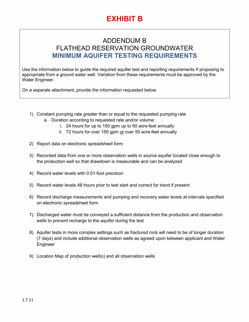
EXHIBIT B
1.7.11
ADDENDUM B
FLATHEAD RESERVATION GROUNDWATER MINIMUM AQUIFER TESTING REQUIREMENTS
Use the information below to guide the required aquifer test and reporting requirements if proposing to appropriate from a ground water well. Variation from these requirements must be approved by the Water Engineer. On a separate attachment, provide the information requested below.
1) Constant pumping rate greater than or equal to the requested pumping rate a. Duration according to requested rate and/or volume:
i. 24 hours for up to 150 gpm up to 50 acre-feet annually ii. 72 hours for over 150 gpm or over 50 acre-feet annually
2) Report data on electronic spreadsheet form
3) Recorded data from one or more observation wells in source aquifer located close enough to
the production well so that drawdown is measurable and can be analyzed
4) Record water levels with 0.01-foot precision
5) Record water levels 48 hours prior to test start and correct for trend if present
6) Record discharge measurements and pumping and recovery water levels at intervals specified on electronic spreadsheet form
7) Discharged water must be conveyed a sufficient distance from the production and observation
wells to prevent recharge to the aquifer during the test
8) Aquifer tests in more complex settings such as fractured rock will need to be of longer duration (7 days) and include additional observation wells as agreed upon between applicant and Water Engineer
9) Location Map of production well(s) and all observation wells