1 Maine GeoArchives Project and the Digital Archives Concept Presented at NAGARA, SAA, CoSA joint...
21
1 Maine GeoArchives Maine GeoArchives Project and the Project and the Digital Archives Digital Archives Concept Concept Presented at NAGARA, SAA, CoSA joint conference, Washington, DC, August 3, 2006 Jim Henderson, Maine State Archivist
-
date post
21-Dec-2015 -
Category
Documents
-
view
218 -
download
0
Transcript of 1 Maine GeoArchives Project and the Digital Archives Concept Presented at NAGARA, SAA, CoSA joint...

1
Maine GeoArchives Project and Maine GeoArchives Project and the Digital Archives Conceptthe Digital Archives Concept
Presented at NAGARA, SAA, CoSA joint conference, Washington, DC, August 3, 2006
Jim Henderson, Maine State Archivist

2
Digital Archives GoalsDigital Archives Goals
Preserve permanently valuable State of Maine official records that are in digital form, either "born digital" or digitized for access, and
Provide continuing digital access to these records.

3
Digital Archives ContextDigital Archives Context
State has spent a billion dollars in the past fifteen years creating systems to produce digital records.
Often to replace "legacy" systems whose records are not accessible: media deterioration or obsolescence, software or O/S obsolescence, inadequate documentation.
Little has been done to protect the long-term and permanent value of these assets.
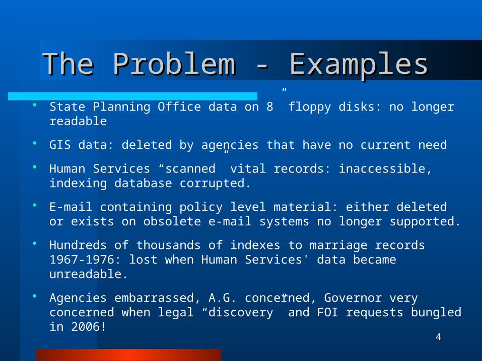
4
The Problem - ExamplesThe Problem - Examples State Planning Office data on 8” floppy disks: no longer readable
GIS data: deleted by agencies that have no current need
Human Services “scanned” vital records: inaccessible, indexing database corrupted.
E-mail containing policy level material: either deleted or exists on obsolete e-mail systems no longer supported.
Hundreds of thousands of indexes to marriage records 1967-1976: lost when Human Services' data became unreadable.
Agencies embarrassed, A.G. concerned, Governor very concerned when legal “discovery” and FOI requests bungled in 2006!

5
Archives Digital ExperienceArchives Digital Experience
1999 Digital Records Management Plan from “Camp Pitt” process and NHPRC
E-mail guidance for State employees since 1997
Scanned/cataloged hundreds of documents for Maine on-line “museums” and learning environments
Mass digitization: 19,000 images from archival microfilm - 2004
Education of Maine IT professionals and other agencies on need to retain selected digital records
GeoArchives GIS preservation project 2005, now institutionalized
Maine Digital Archives Planning - 2005-2006
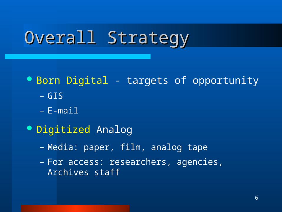
6
Overall StrategyOverall Strategy
Born Digital - targets of opportunity
– GIS
Digitized Analog
– Media: paper, film, analog tape
– For access: researchers, agencies, Archives staff

7
Digital Archives ProcessDigital Archives Process

8
GeoArchives Project Goal, ObjectivesGeoArchives Project Goal, Objectives
Goal Digital system, based on current research and standards,
to preserve and provide access to, State GIS records having permanent value.
Objectives– Immediate reduction in the loss of archival GIS records – A prototype for continuing development and application
for all State and local GIS records.– A model for others to critique, improve, apply

9
Project Scope - LimitedProject Scope - Limited
Preservation– Data (layers, images) in GeoLibrary only
• A large subset of all GIS records in agencies• Vetted for FGDC metadata compliance
– Select Test Data from GeoLibrary• Relatively stable - municipal boundaries• Relatively dynamic - E911 Roads• Orthophoto Imagery from “Fly Overs”
Access– Use existing GeoLibrary– Compare layer status (boundaries, roads) at any historical time– Overlay different layers (boundaries 2005; roads 2010)
10
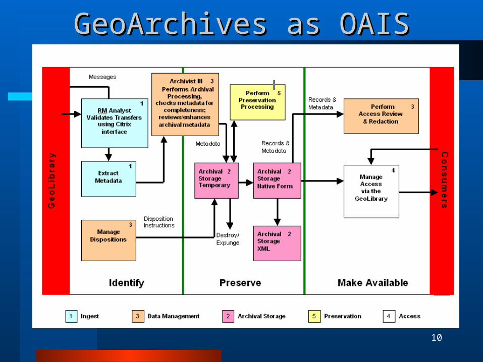
GeoArchives as OAISGeoArchives as OAIS

11
Project ProcessProject Process
Research Project Team - true collaboration User needs - survey Functional Requirements
– for the project– for the outcome
Consultants - multiple Metadata Requirements
– Dublin Core, MARC 21, FGDC– Crosswalks FGDC v. archival standards

12
Project Functional RequirementsProject Functional Requirements
Identify GIS administrative records Set appraisal level - attributes, layers Appraise data layers Determine additional metadata needs Provide for data integrity and security Provide access to archival GIS data Define Archive’s administrative procedures
Functional requirements document:http://www.maine.gov/geoarch/Project%20Proposal%20and%20Documents/Frgeo08.doc
FOR MORE INFO...

13
FGDC Metadata for Appraisal and FGDC Metadata for Appraisal and Archival DescriptionArchival Description Originator [Administrative
records]
Title [Unique Identifier]
Series_Name [Descriptive name]
Abstract [Legal, informational, evidential value; related digital data]
Purpose [Evidential value]
Time_Period_InformationBeginning_Date [Existing archival layer]
Ending_Date [Existing archival layer]
Status Progress [Periodicity of accession]
Maintenance_and_Update_Frequency
Point_of_Contact Contact_Organization_Primary
[Administrative records]
Contact_Address [Administrative records]
Overview_Description
[Legal, informational, evidential value]
Entity_And-Attribute_Overview [Legal, informational, evidential value]
Use_Constraints [Access restrictions]
Source_Information Originator [Scope and content accuracy]
Contribution [Scope and content accuracy]

14
Additional Archival MetadataAdditional Archival Metadata
Creator’s content in FGDC Metadata– Assess completeness for archival description– Enhance as needed
Archive’s content in FGDC Metadata– Citation - Maine State Archives as data owner
– Keywords - Library of Congress Thesaurus
– Contact - MSA phone, address ,etc.
– Process Description - description of accession process
– Metadata Access Constraints - notice “no changed
permitted to archival version”
15
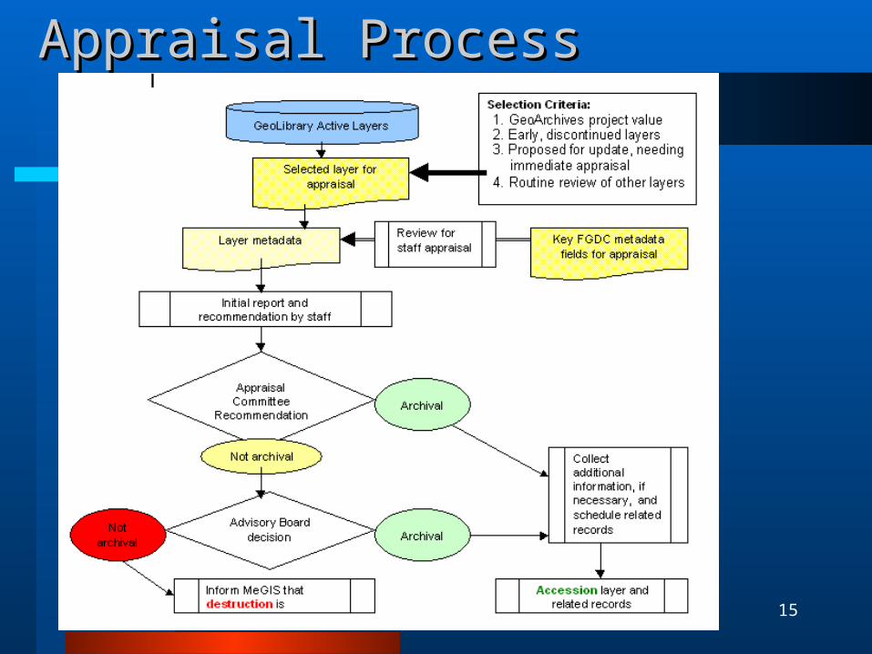
Appraisal ProcessAppraisal Process
16
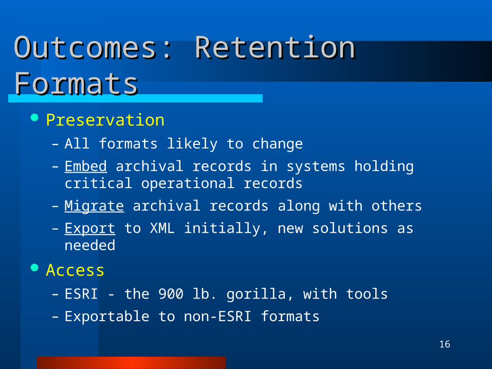
Outcomes: Retention FormatsOutcomes: Retention Formats
Preservation– All formats likely to change
– Embed archival records in systems holding critical operational records
– Migrate archival records along with others
– Export to XML initially, new solutions as needed
Access– ESRI - the 900 lb. gorilla, with tools
– Exportable to non-ESRI formats

17
Manual for Managing the GeoArchivesManual for Managing the GeoArchives
Appraisal Process– Key metadata fields– Decision-making process
Accession Process– Review current metadata– Add archival metadata to change ownership– Administrative Records– Post Accession (error correction)
18
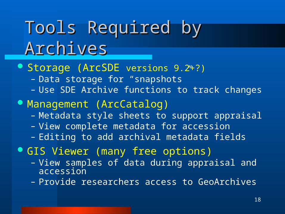
Tools Required by ArchivesTools Required by Archives
Storage (ArcSDE versions 9.2+?)– Data storage for “snapshots”– Use SDE Archive functions to track changes
Management (ArcCatalog)– Metadata style sheets to support appraisal– View complete metadata for accession– Editing to add archival metadata fields
GIS Viewer (many free options)– View samples of data during appraisal and accession– Provide researchers access to GeoArchives

19
Maine GeoArchives: StatusMaine GeoArchives: Status
A model for Digital Archives: design, experience
“Snapshot” layers on Data Catalog
http://megis.maine.gov/catalog/
On-going assessment for “continuous layer history” solution
Manual for Managing the GeoArchives
Receiving update alerts for data layers
Appraisal and accessioning continues
20
The The DevilDevil - Lessons on Details - Lessons on Details
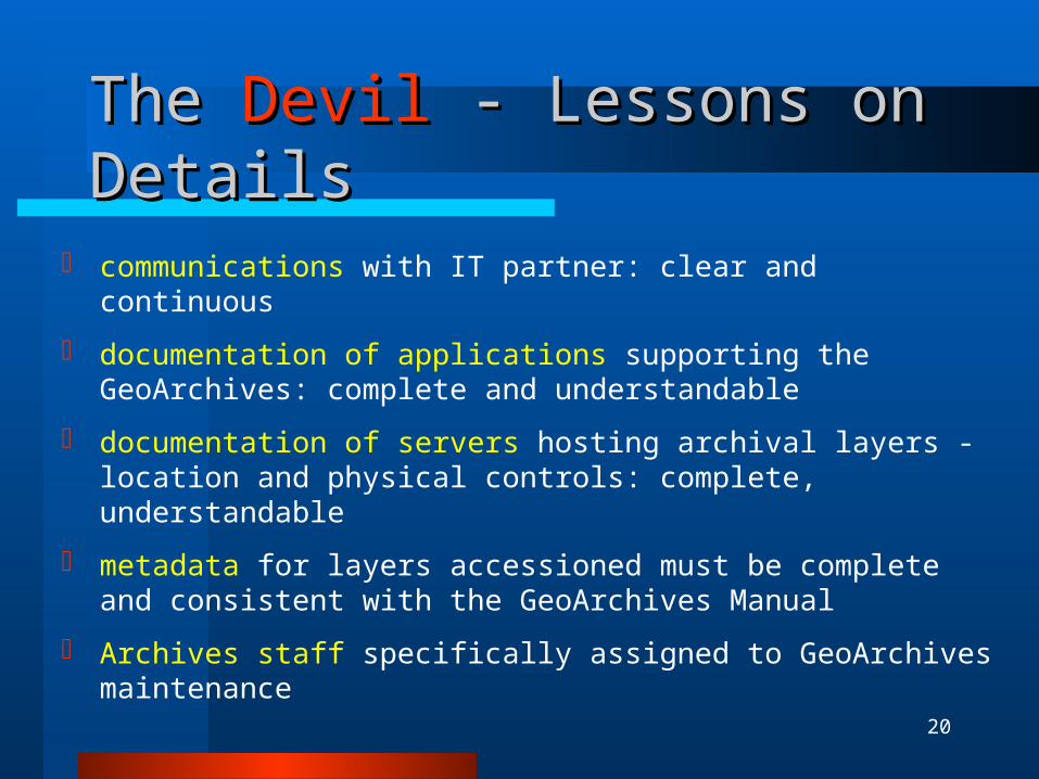
communications with IT partner: clear and continuous
documentation of applications supporting the GeoArchives: complete and understandable
documentation of servers hosting archival layers - location and physical controls: complete, understandable
metadata for layers accessioned must be complete and consistent with the GeoArchives Manual
Archives staff specifically assigned to GeoArchives maintenance

21
Maine GeoArchives Web SiteMaine GeoArchives Web Site Agendas, Minutes Project Documents - raw and refined
– Functional Requirements– Manual for Managing the GeoArchives– Administrative Records Schedule– Consultant reports– Project Final Reports
GeoArchives Web:
http://www.maine.gov/sos/arc/GeoArchives/geoarch.html
FOR MORE INFO...