Pengukuran Kedudukan Unsur Struktur Geologi Dengan Meggunakan Kompas Geologi
Upload
yudhistira-bedduCategory
view
244download
5
Classifications of Eruption Based on Form and Location of
the Vent
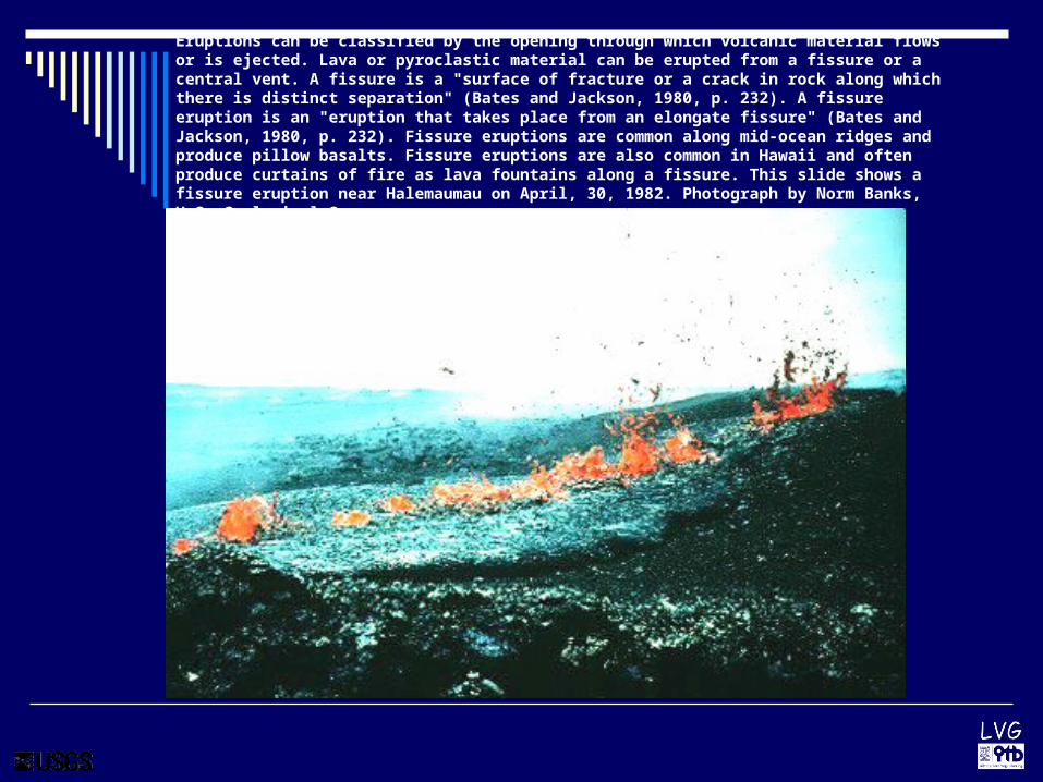
Eruptions can be classified by the opening through which volcanic material flows or is ejected. Lava or pyroclastic material can be erupted from a fissure or a central vent. A fissure is a "surface of fracture or a crack in rock along which there is distinct separation" (Bates and Jackson, 1980, p. 232). A fissure eruption is an "eruption that takes place from an elongate fissure" (Bates and Jackson, 1980, p. 232). Fissure eruptions are common along mid-ocean ridges and produce pillow basalts. Fissure eruptions are also common in Hawaii and often produce curtains of fire as lava fountains along a fissure. This slide shows a fissure eruption near Halemaumau on April, 30, 1982. Photograph by Norm Banks, U.S. Geological Survey.

In contrast, a central vent is the "opening at the Earth's surface of a volcanic conduit of cylindrical or pipelike form" (Bates and Jackson, 1980, p. 102). A central eruption is the "ejection of debris and lava flows from a central point, forming a more or less symmetrical volcano" (Bates and Jackson, 1980, p. 102). The 1991 eruption of Mount Pinatubo and the 1980 explosive eruption of Mount St. Helens, after the lateral blast, are examples of central eruptions. A central eruption continued at Mount St. Helens as a volcanic dome grew within the crater of the volcano. Central eruptions also occur in Hawaii, such as the explosive eruption of 1790 or the 1967-1968 lava lake in Halemaumau.
Characteristics of Water-Related
Eruptions

Characteristics of Water-Related Eruptions
McClelland and others (1989) reported on 388 documented volcanic eruptions from 1975 to 1985. They found four characteristic ways that water interacts with eruptions: submarine eruptions, formation of new islands, subglacial
eruptions, and crater lakes.

Shallow water eruptions are characterized by steam explosions that produce islands made of tephra. In most cases, the islands are eroded by ocean waves. In some cases lava is erupted subaerially and forms a protective cap on the island. Formation of a new Hawaiian island has not occurred in the recent geologic past
Characteristics of Water-Related Eruptions

VEIThe Volcanic Explosivity Index, or VEI, was proposed in 1982 as a way to describe the relative size or magnitude of explosive volcanic eruptions. It is a 0-to-8 index of increasing explosivity. Each increase in number represents an increase around a factor of ten. The VEI uses several factors to assign a number, including volume of erupted pyroclastic material (for example, ashfall, pyroclastic flows, and other ejecta), height of eruption column, duration in hours, and qualitative descriptive terms.

Volcanic interactions with the atmosphere
Ozone depletion promoted by volcanic sulfur aerosols. The sulfate aerosols also promote complex chemical reactions on their surfaces that alter chlorine and nitrogen chemical
species in the stratosphere. This effect, together with increased stratospheric chlorine levels from chlorofluorocarbon (CFC) pollution, generates chlorine monoxide (ClO), which
destroys ozone (O3).

At the same time, part of the fountain was deflected northward across the lava river to form spectacular V-shaped fountains

The Mauna Loa eruption of 1984 fed a major lava flow that advanced toward the city of Hilo. (Photograph provided by National Park Service)

TephraAs tephra falls to the ground with increasing distance from a volcano, the average size of the individual rock particles becomes smaller and thickness of the resulting deposit becomes thinner. Small tephra stays aloft in the eruption cloud for longer periods of time, which allows wind to blow tiny particles farther from an erupting volcano.
Volcanic ash falls to ground and creates darkness, Mount Pinatubo in the Philippines.

TephraTephra is a general term for fragments of volcanic rock and lava regardless of size that are blasted into the air by explosions or carried upward by hot gases in eruption columns or lava fountains. Tephra includes large dense blocks and bombs, and small light rock debris such as scoria, pumice, reticulite, and ash.
Tephra erupted by Mount St. Helens on 18 May 1980 ranging in size from ash (left 2 piles) to lapilli (right 2 piles).

Typical stratigraphic section of 1991 tephra-fall deposits southwest of Mount Pinatubo. Sketch of section located at Sitio (hamlet) Upper Kakilingan, San Marcelino (location KAK, fig. 7), about 13 km south-southwest of the volcano. Eruptive phases are those defined by Wolfe and Hoblitt (this
volume).

LLaharaharLahar is an Indonesian word for a rapidly flowing mixture of rock debris and water that originates on the slopes of a volcano. Lahars are also referred to as volcanic mudflows or debris flows. They form in a variety of ways, chiefly by the rapid melting of snow and ice by pyroclastic flows, intense rainfall on loose volcanic rock deposits, breakout of a lake dammed by volcanic deposits, and as a consequence of debris avalanches
A small lahar triggered by rainfall rushes down the Nima II River near the town of El Palmar in Guatemala. The lahar developed on the slopes of Santiaguito volcano.
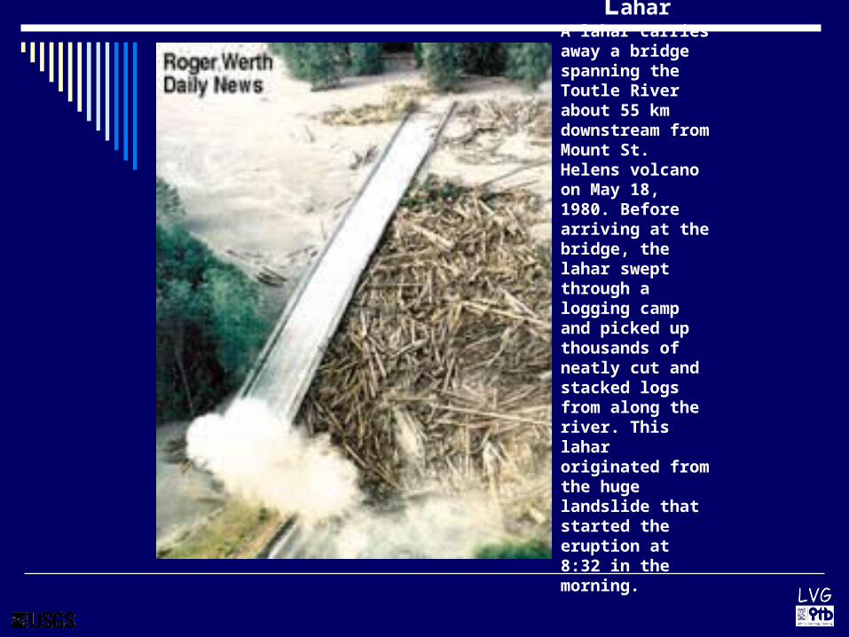
LaharA lahar carries away a bridge spanning the Toutle River about 55 km downstream from Mount St. Helens volcano on May 18, 1980. Before arriving at the bridge, the lahar swept through a logging camp and picked up thousands of neatly cut and stacked logs from along the river. This lahar originated from the huge landslide that started the eruption at 8:32 in the morning.

In the years since the 15 June 1991 eruption of Mount Pinatubo in the Philippines, sediment carried by rain-induced lahars have displaced more than 50,000 people from their homes and covered at least 400 km2 of rich agricultural land. This view of the Abacan River shows sediment deposited on farmland and a nearby community within 2 months of Pinatubo's explosive eruption. Nearly all the post-eruption lahars have been caused by intense rainfall, especially during typhoons and monsoon season, which easily erodes the loose pyroclastic-flow deposits that fill the headwaters of all rivers draining the volcano.

Photograph by C. Newhall on August 30, 1994This lake formed in 1994 behind a blockage created chiefly by lahar deposits in the Pasig-Portrero River about 12 km from Mount Pinatubo in the Philippines, though some secondary pyroclastic flows may have contributed (the river flows right to left). After a moderate rainfall, the lake broke out on the night of 22 September 1994. A sudden surge of water swept downstream, increasing in size as the rushing water eroded sediment from previous lahar deposits. Approximately 25 people were killed by the lake breakout, mostly in a community located about 15 km downstream.
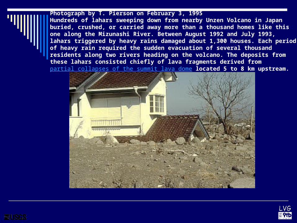
Photograph by T. Pierson on February 3, 1995 Hundreds of lahars sweeping down from nearby Unzen Volcano in Japan buried, crushed, or carried away more than a thousand homes like this one along the Mizunashi River. Between August 1992 and July 1993, lahars triggered by heavy rains damaged about 1,300 houses. Each period of heavy rain required the sudden evacuation of several thousand residents along two rivers heading on the volcano. The deposits from these lahars consisted chiefly of lava fragments derived from partial collapses of the summit lava dome located 5 to 8 km upstream.

Volcanic gasMagma contains dissolved gases that are released into the atmosphere during eruptions. Gases are also released from magma that either remains below ground (for example, as an intrusion) or rises toward the surface. In such cases, gases may escape continuously into the atmosphere from the soil, volcanic vents, fumaroles, and hydrothermal systems. The most common gas released by magma is steam (H2O), followed by CO2
(carbon dioxide), SO2 (sulfur
dioxide), (HCl) hydrogen chloride and other compounds.
Sulfur dioxide and other volcanic gases rise from the Pu`u `O`o vent on Kilauea Volcano, Hawai`i. During periods of sustained eruption from Pu`u `O`o between 1986 and 2000, Kilauea emitted about 2,000 to 1,000 metric tonnes of irritating sulfur dioxide gas (SO2) gas each
day.

Pyroclastic flowA pyroclastic flow is a ground-hugging avalanche of hot ash, pumice, rock fragments, and volcanic gas that rushes down the side of a volcano as fast as 100 km/hour or more. The temperature within a pyroclastic flow may be greater than 500° C, sufficient to burn and carbonize wood. Once deposited, the ash, pumice, and rock fragments may deform (flatten) and weld together because of the intense heat and the weight of the overlying material.
Photograph by C. Newhall on 15 September 1984
Pyroclastic flow sweeps down the side of Mayon Volcano, Philippines

MENANTANG MAUT: Rasa penasaran dan keingintahuan terkadang membuat lupa akan bahaya. melihat letusan Gunung Papandayan dari dekat. Begitu letusan besar terjadi. (Foto: Suara Merdeka/dwi-15)
//www.suaramerdeka.co.id/

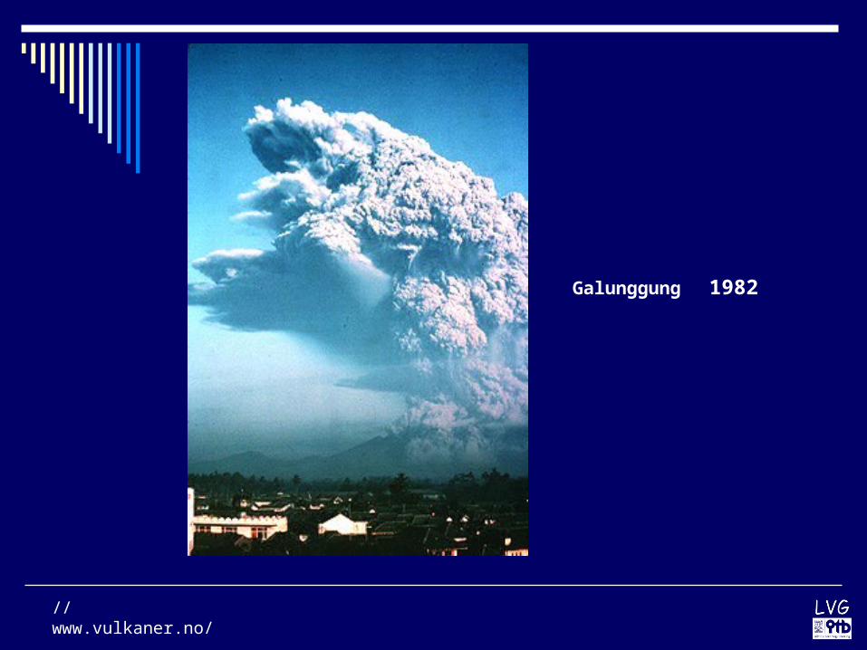
Galunggung is a stratovolcano on the west side of the island of Java. The caldera of Galunggung is open to the southeast. Photo by Jack Lockwood, U.S. Geological Survey, August 17, 1982.
//www.vulkaner.no/
Galunggung 1982

Letusan Galunggung 1982, Tasikmalaya, Jawa Barat
http://volcano.und.nodak.edu/vwdocs/

Gunung Galunggung, 03 Desember 1982
http://volcano.und.nodak.edu/vwdocs/

Kerusakan akibat letusan G. Galunggung 1982
http://volcano.und.nodak.edu/vwdocs/

At Mount Pinatubo in the Philipines, pyroclastic flow deposits were 220 m thick in some valleys but averaged 30 to 50 m thick in others (Wolfe, 1992). Pyroclastic flows have been known to top ridges 1000 m high (Bryant, 1991). The image on the left shows a pyroclastic flow descending Fuego Volcano in Guatemala (photo by W.C. Buell IV, 1974).

Photograph by W.E. Scott on July 1, 1991.
Pyroclastic flows erupted by Mount Pinatubo on June 15, 1991, buried the Marella River valley (SW of Pinatubo) with pumice, ash, and other volcanic rocks to depths of between 50 and 200 m. This eruption was one of the largest in the 20th century, depositing about 5.5 km3 of rock debris over nearly 400 km2. The pyroclastic flows traveled as far as 12 to 16 km from the volcano in all directions. Unlike river valleys, the steep slopes around the volcano were veneered with very thin, discontinuous pyroclastic-flow deposits.

The 1924 explosive eruption of Kilaeua mainly affected the immediate vivinity of Halemaumau crater. (Photograph courtesy of the Bishop Museum)

Mammoth Mountain, a young volcano in eastern California, sits on the southwest rim of Long Valley Caldera. In 1994, scientists detected high concentrations of CO2 gas in the soil on Mammoth Mountain. This invisible gas, seeping from beneath the volcano, is killing trees on the sides of the mountain and can pose a threat to humans. Recent measurements indicate that the total rate of CO2 gas emission at Mammoth Mountain is close to 300 tons per day. In this photo, large areas of dead and dying trees are visible near Horseshoe Lake, on the southeast flank of Mammoth Mountain. (Copyrighted photo courtesy of John D. Rogie.)

Bread-crust blocks are rounded or angular lumps with a smooth, glassy crust broken by deep cracks and fissures, exposing the frothy, vesicular core of the bomb, and reminiscent of a well-baked, crusty loaf of bread. Bread-crust blocks are formed when lumps of viscous, gas-rich lava are ejected from the vent: the outer crust chills quickly to form the glassy crust, but the interior remains hot, and continues to vesiculate, frothing up the interior. As in a decently baked loaf, the internal expansion causes the brittle outer crust to crack. This block was found in the Socompa debris avalanche deposit. It shows that hot magma was present within the volcano when the catastrophic flank failure took place, since the vesiculated brittle block would have broken up during transport. Similar blocks are often found as ejected bombs in vulcanian pyroclastic deposits.

This is an image of a pyroclastic flow deposit from Mount St. Helens, August 1980.

Pumice from Krakatau floating on the ocean

This lapilli was erupted by Pu`u Pua`i (gushing hill) from the summit of Kilauea Volcano in 1959 and fell to the ground about 800 m downwind. See summary of this spectacular eruption.
LapilliRock fragments between 2 and 64 mm (0.08-2.5 in) in diameter that were ejected from a volcano during an explosive eruption are called lapilli. Lapilli (singular: lapillus) means "little stones" in Italian. Lapilli may consist of many different types of tephra, including scoria, pumice, and reticulite.
Rounded tephra particles in this size range are called accretionary lapilli if they consist of tiny ash grains stuck together. Ash sometimes form such rounded particles in an eruption column or cloud, owing to moisture or electrostatic forces.
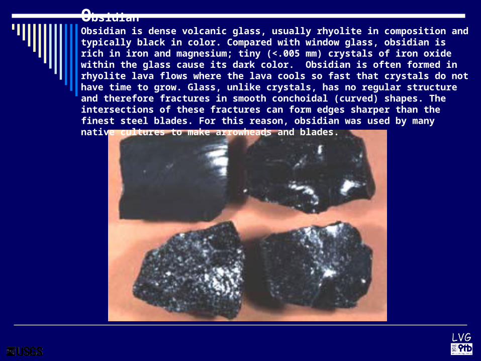
ObsidianObsidian is dense volcanic glass, usually rhyolite in composition and typically black in color. Compared with window glass, obsidian is rich in iron and magnesium; tiny (<.005 mm) crystals of iron oxide within the glass cause its dark color. Obsidian is often formed in rhyolite lava flows where the lava cools so fast that crystals do not have time to grow. Glass, unlike crystals, has no regular structure and therefore fractures in smooth conchoidal (curved) shapes. The intersections of these fractures can form edges sharper than the finest steel blades. For this reason, obsidian was used by many native cultures to make arrowheads and blades.

Vulcano last erupted from 1888 to 1890. The eruption deposited 15 feet (5 m) of pyroclastic material at the summit of Fossa. Bombs about 3 feet (1 m) in diameter fell 0.6 miles (1 km) from the vent.

Pyroklastiske flommer under utbruddet fra den 10.februar til den 17.februar i 1990 ødela store jordbruksområder

TEPHRA
The Puu Oo cone, the main vent for Kilauea from 1983-1986, is made of cinder and spatter from numerous lava fountains. Photograph by J.D. Griggs, U.S.
Geological Survey,

Photo of the "fire hose" flow, a small lava tube pouring into the ocean. Photograph by J.D. Griggs, U.S. Geological Survey, November
THE CURRENT ERUPTION OF KILAUEA VOLCANO

Colima Volcano, Mexico.A stubby andesite lava flow advances 900-1,200 m down the southwest side of Colima Volcano. Lava was first observed in the summit crater on November 20 and began spilling over the crater rim the next day. Colima Volcano is the most historically active volcano in Mexico. For more information about Colima, see the volcanic activity reports provided by the Smithsonian Institution's Global Volcanism Program.
Photograph by Juan Carlos Gavilanes on 3 December 1998; Universidad de Colima
http://volcanoes.usgs.gov/

Volcanic ashIt consists of rock, mineral, and volcanic glass fragments smaller than 2 mm (0.1 inch) in diameter, which is slightly larger than the size of a pinhead. Volcanic ash is not the same as the soft fluffy ash that results from burning wood, leaves, or paper. It is hard, does not dissolve in water, and can be extremely small--ash particles less than 0.025 mm (1/1,000th of an inch) in diameter are common. Ash is extremely abrasive, similar to finely crushed window glass, mildly corrosive, and electrically conductive, especially when wet. Volcanic ash is created during explosive eruptions by the shattering of solid rocks and violent separation of magma (molten rock) into tiny pieces. Explosive eruptions are generated when ground water is heated by magma and abruptly converted to steam and also when magma reaches the surface so that volcanic gases dissolved in the molten rock expand and escape (explode) into the air extremely rapidly. After being blasted into the air by expanding steam and other volcanic gases, the hot ash and gas rise quickly to form a towering eruption column directly above the volcano.

Bubbling mud pot at Kawah Sikidang. Mud temperature 76.7 deg C. Ground temperature next to vent 33.2 deg C

Sulfur gas is condensed in the crater and mined.