1. Exploring unstructured … 2. … SPM (Mud) modelling Waddenzee
48
1. Exploring unstructured … 2. … SPM (Mud) modelling Waddenzee 1. Gerben J. de Boer – Deltares / TU Delft / Building with Nature 2. Thijs van Kessel - Deltares Rijkswaterstaat (VOP slib) research program 2004-2010
Transcript of 1. Exploring unstructured … 2. … SPM (Mud) modelling Waddenzee

1. Exploring unstructured …2. … SPM (Mud) modelling Waddenzee1. Gerben J. de Boer – Deltares / TU Delft / Building with Nature2. Thijs van Kessel - Deltares
Rijkswaterstaat (VOP slib) research program 2004-2010

TU Delft Texel Outer Delta reduced (Elias)
• Effect-chain WaddenSea 2004:
Long term fine sediment balance
Western W’zee, process-based
• 1st model considered
• Edwin Elias, TU Delft,
• meant for sand morphology
• not suitable for mud
? front door
? back door
? window
? window

Deltares classic 3D model (Borsje et al, 2008)
• 2nd model considered 2005
• RWS kuststrook coarsened
• 90% of cells removed &
• increased 2D to 3D 10 layers
• SPM studies < 2000
• insufficient drying/flooding
?
?
?
?
?
?

Rijkswaterstaat kusthoogte gridded Lidar (5m)
DATA: RWS kusthoogte
• Lidar points every year 1996 +
• same procedure as AHN2
• gathered at LLWS
• raw points every O (1m)
• for calibration flooding/drying?

Rijkswaterstaat KuststrookFijn model
RWS kuststrook fine: best !
• 2D, meant for storm surges
• and circulation patterns?
• too heavy for 3D dispersal
• still lack of relevant resolution
• run daily by Rijkswaterstaat
• wadlopen still not possible

Rijkswaterstaat vaklodingen (20m)
DATA
• ship multibeam / singlebeam
• processed into vaklodingen tiles
by RWS every ~ 5 years
• gully pattern never in models
• needed for flooding/drying
• roughness only affects timing

A new start: unstructured Delft3D-FM
We need to start all over again
Different paradigm needed
• Subgrid: drying/flooding at
smaller subgrid, not ready
• Schematized: compartments
e.g. Wang, Van Prooijen
• Unstructured: fine where needed
2D finished, 3D upcoming
triangles on flats
coarse curvi-linear
at sea
elongated curvi-linear in channels
Flexible Mesh

1+2 Curvi-linear: local refinement = global refinement
• Grid was already available• Low quality (not so smooth)• ~ 22,000 cells• 0 hours work
Goal: Compare 5 simulations:1. Classic curvi-linear Delft3D-2dh2. same solved “unstructuredly”

3 Quick grid: domain decomposition with triangle-glue
• Existing grid chopped up > in w’zee refined> at sea coarsened
• similar to domain decomposition
• ~ 25,000 cells• 4 hours work3. new Delft3D-FM quick curvi-
linear patches glued w. triangles

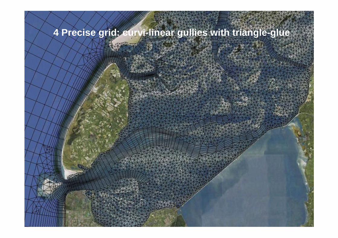
4 Precise grid: curvi-linear gullies with triangle-glue
• Existing grid chopped up > at sea coarsened> gullies fitted (ducktape)> flats filled up (pur)
• ~ 19,000 cells• 4 days work + ongoing
4. precise (no results yet)5. 100% triangles (not started yet)

1+2 Curvi-linear: local refinement means global refinement

3 Quick grid: domain decomposition with triangle-glue
4 Precise grid: curvi-linear gullies with triangle-glue

State indicators to be assessed
How to assess which of the 5 best ?
• Quantitative: general lack of data! (for SPM: Thijs)1. Water levels (Rijkswaterstaat) only along coast
> check tidal response> check wind response
2. Bathymetric changes (RWS bathymetry)3. Net and gross fluxes through Marsdiep
> NIOZ ADCP (not open)4. RWS Lidar map to shown drying flooding at LLWS
> Can we finally go ‘wadlopen’ in our models?5. T + S biweekly samples (MWTL)6. NIOZ jetty: T + S• Remote sensing perhaps: few cm water gives issues
• Qualitative:• What does M2/M4 performance in channels and flats do?
Available as ‘youTube’web-service for Matlab, Python, R, Java:

initial conditions
Results in Harlingen, jan - jun 1998
initial conditions
Delft3D-2dh Delft3D-FM (same grid) Delft3D-FM (new grid)

Results in Schiermonnikoog, jan - jun 1998
Delft3D-2dh Delft3D-FM (same grid) Delft3D-FM (new grid)
Same coarse bathymetry, power of numerical schemes!
Rest to be solved with relevant resolution

Next: tiles > linear bathymetry
• Previous models were finer grid with same coarse depth data• Redo bathymetry use high-resolution bathymetry:
• Classic piecewise flat bed in Delft3D-flow-alikes• New linear conveyance concept in Delft3D-FM
Delft3D-flow alikes
Conveyance concept
100% wet100% dryx % wet 100 % wet

SPM (Mud) Modelling Waddenzee
Thijs van Kessel, Gerben de Boer

Mud balance
C North Sea = 10 mg/LC Wadden Sea = 80 mg/L
Area Wadden = 2573 km2, depth = 2.7 m V = 7 109 m3
W = 0,56 MT; V tide = 3,4 109 m3
Net EXport = Vtide (CWS – CNS) = 0.24 MT/tide = 165 MT/year
However: IMport estimated at 3 MT kg/yearTransport against concentration gradient because of:
• tidal assymetry• settling/scour lag• estuarine circulation• channel-mudflat interaction

‘Old’ model results
• Old model• 2D• mean tide• coarse grid• average wind• single seabed layer with simple erosion formulation
EITHER• SPM levels OK, but strong sediment export
OR• Sediment budget OK, but much too low SPM levels

Model results 2004

Model results 2004
-2891
3839948
180
125
294
-2046
-266
-1821 -1264
-60605
466
1944 1558
58559
500
green = net inputred = gross inputblue = gross output
in kton/year}
-9506
9442
-65
29
-200
-1852
1559-1259
-5635 -3410
-426442
1287
5434 1558
427981
500
green = net inputred = gross inputblue = gross output
in kton/year}

Developments
• 2D 3D• higher resolution, unstructured grid for local detail• longer timescale with real forcing (tide, wind, river discharge)• 2 seabed layers, improved erosion formulation (allowing for
equilibrium bed composition)
‘New’ model results
SPM concentration distributionbed compositiontemporal SPM dynamicsexample difference 2D – 3DMud balance

Model results: 2010 SPM (mg/L)

Model results 2010: mud fraction bed
2004
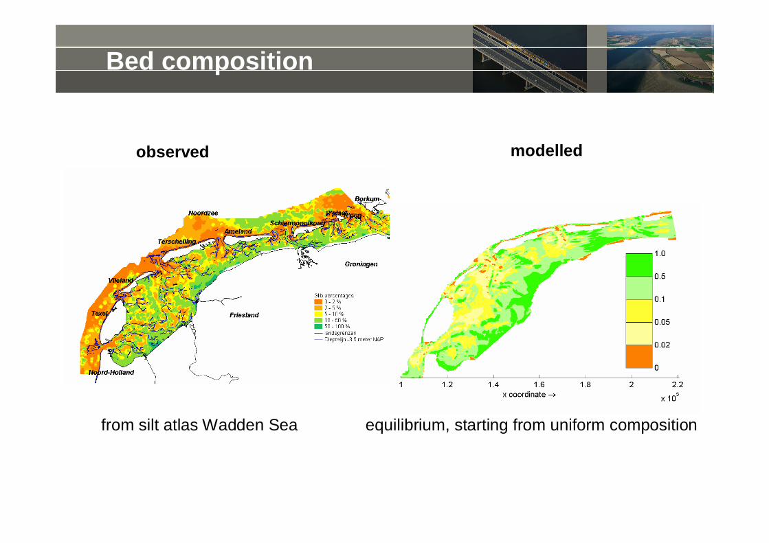
Bed composition
observed modelled
equilibrium, starting from uniform compositionfrom silt atlas Wadden Sea

Results 2010/2004 Marsdiep
Marsdiep noord
0
20
40
60
80
100
120
1-1 31-1 2-3 1-4 1-5 31-5 30-6 30-7 29-8 28-9 28-10 27-11 27-12date
conc
. (m
g/l)
DONARcomputed

Results 2010/2004 Blauwe Slenk Oost
Blauwe Slenk oost
0
50
100
150
200
250
300
1-1 31-1 2-3 1-4 1-5 31-5 30-6 30-7 29-8 28-9 28-10 27-11 27-12
date
conc
. (m
g/l)
DONARcomputed

Comparison 2D – 3D
2D 3D

Comparison 2D – 3D

Water balance 1998 (m3/s)
IN OUT NETMarsdiep 22,941 -24,613 -1,672Eierlandsegat 3,346 -3,502 -155Vliestroom 22,444 -21,585 859Borndiep 9,852 -9,688 165Zoutkamperlaag 7,219 -7,094 125Wadden Sea (east) 3,030 -3,031 -1
loads 634 0 634

Mud balance 1998 (MT/year)
IN OUT NET43.6 -43.4 0.39.7 -9.9 -0.2
38.3 -37.8 0.525.8 -27.0 -1.236.2 -35.7 0.616.4 -16.6 -0.2
0.5 0.0 0.50.0 -0.1 -0.1
3,844.5 0.0 -0.50.0 -3,845.0
MarsdiepEierlandsegatVliestroomBorndiepZoutkamperlaagWadden Sea (east)
loadsstorageerosiondeposition
N.B suspended mass ~1 MT; bottom mass > 100 MT

Conclusions
• Substantial progress during past 6 years (even without unstructured grids)
• Present SPM model shows fine sediment import into Wadden Seanotwithstanding strong concentration gradient with North Sea
• Time scale to reach dynamic equilibrium many years
• SPM model needs to be further calibrated
• More field data required for model calibration, as available data do not at all cover the highly variable SPM dynamics
• But… model already useful for system understanding, sensitivity studies and to optimise field observervation strategy

Problem: lack of data
What we would like to see also in the Wadden Sea…

Desired situation
Towards availability of high resolution temporal and spatial data

Desired situation
?
Existing and future datasets
• TESO ferry• NIOZ jetty• station Balgzand• …

Delft3D-2dh
Delft3D-FM (same)
Uncalibrated results (3D model run in 2D)

Uncalibrated results (3D model run in 2D)
Delft3D-2dh
Delft3D-FM (same)

Harlingen
Delft3D-2dh
Delft3D-FM

The issue: Wadden sea bathymetry resolutions
For SPM models a hydrodynamic schematization is always the baseMaking schematizations is a lot of work (~ months)So people often recycle existing schematizations or do quick-n-dirty:• RWS kuststrook fijn• Dedicated morphology of one tidal basin (e.g. Elias Texel Outer Delta)• An existing wadden sea model (based on kuststrook fijn)Often inappropriate due to lack of relevant resolutionSpecific research questions should govern the schematization• Storm surge (2D) flow circulation (3D)• Morphology (channel migration) mud deposition (flats with small gullies)• In none of the current models wadlopen is possible!HENCE: we want more dedicated resolution:• Exploring unstructured model Delft3D-FM now being developed (only 2D)• Future: subgrid: solve only drying/flooding on underlying high resolution

The hybrid approach for the D-flow grid: FM
triangles on flats
curvi-linear at sea
curvi-linear on channels

Goal
• Repeat hydrodynamics used also by Borsje et al. (2008)• Redo their SPM (not biology) with new grids• Compare unstructured results with classic structured approach• Investigate whether unstructured is the way to proceed

Approach
Resolve hydrodynamics + SPM on 5 grids;1. Classic curvi-linear Delft3D-2dh (Delft3D open source 1-1-2011!)2. new Delft3D-FM on same curvi-linear grid, solved “unstructuredly”3. new Delft3D-FM quick curvi-linear patches glued w. trianglesMaking grids is laborious! Work in progress:4. Delft3D-FM precise patches glued w. triangles (no results yet)5. 100% triangles, not recommended (not started yet)
• Note: Delft3D-WAQ/SED is already unstructured, so work of Thijscan simply be redone.
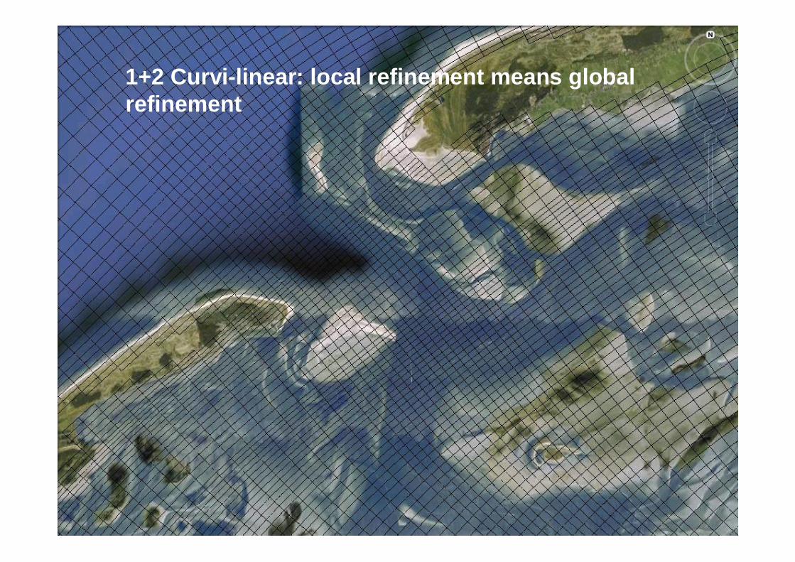
1+2 Curvi-linear: local refinement means global refinement

3 Quick grid: domain decomposition with triangle-glue

4 Precise grid: curvi-linear gullies with triangle-glue