1. EXPERIENCE OF REGIONAL PREDICTION OF …
18
Oil and Gas Exploration: Methods and Application, Monograph Number 72, First Edition. Edited by Said Gaci and Olga Hachay. © 2017 American Geophysical Union. Published 2017 by John Wiley & Sons, Inc. 1 1. EXPERIENCE OF REGIONAL PREDICTION OF HYDROCARBON DEPOSITS PROSPECTING IN THE VICINITY OF URAL OIL AND GAS PROVINCES Vladimir S. Druzhinin, Vjacheslav Osipov, and Nikolay Nachapkin 1 Abstract This chapter is devoted to investigating oil and gas content in the Ural region according to the position of the Earth’s crust deep structure. A significant volume of deep seismic soundings was provided in the Ural region by the Bagenov geophysical expedition, by the Institute of Geophysics (Ural Branch of Russian Academy of sciences), and by the Center of Regional Geophysical Research (GEON) during some decades. We have elaborated a new technology of seismic geomapping, based on new model conceptions about the structure of the upper part of lithosphere. We sup- plement the base of seismic research by the geological data (information about the oil and gas content of the region), the data of super deep bore- holes, and area gravimetric data. That allowed us to construct a geological‐ geophysical fault‐block volume model of the lithosphere (up to 80 km), to provide the tectonic mapping according to these cuts: the surface of ancient crystalloid crust and the main seismic geological surface M. On the basis of the obtained information compared with the data of hydrocarbon deposits location, new depth criteria of forecasting deposits in new regions and objects have been developed. We can assign some examples of positive fore- casting. They are the Kueda region (south of Perm region) and the region of the town Khanti‐Mansyisk. Institute of Geophysics Ural Branch of Russian Academy of Sciences (UB RAS), Ekaterinburg, Russia COPYRIGHTED MATERIAL
Transcript of 1. EXPERIENCE OF REGIONAL PREDICTION OF …

Oil and Gas Exploration: Methods and Application, Monograph Number 72, First Edition. Edited by Said Gaci and Olga Hachay. © 2017 American Geophysical Union. Published 2017 by John Wiley & Sons, Inc.
1
1. EXPERIENCE OF REGIONAL PREDICTION OF HYDROCARBON DEPOSITS PROSPECTING
IN THE VICINITY OF URAL OIL AND GAS PROVINCESVladimir S. Druzhinin, Vjacheslav Osipov, and Nikolay Nachapkin
1
Abstract
This chapter is devoted to investigating oil and gas content in the Ural region according to the position of the Earth’s crust deep structure. A significant volume of deep seismic soundings was provided in the Ural region by the Bagenov geophysical expedition, by the Institute of Geophysics (Ural Branch of Russian Academy of sciences), and by the Center of Regional Geophysical Research (GEON) during some decades. We have elaborated a new technology of seismic geomapping, based on new model conceptions about the structure of the upper part of lithosphere. We supplement the base of seismic research by the geological data (information about the oil and gas content of the region), the data of super deep boreholes, and area gravimetric data. That allowed us to construct a geological‐geophysical fault‐block volume model of the lithosphere (up to 80 km), to provide the tectonic mapping according to these cuts: the surface of ancient crystalloid crust and the main seismic geological surface M. On the basis of the obtained information compared with the data of hydrocarbon deposits location, new depth criteria of forecasting deposits in new regions and objects have been developed. We can assign some examples of positive forecasting. They are the Kueda region (south of Perm region) and the region of the town Khanti‐Mansyisk.
Institute of Geophysics Ural Branch of Russian Academy of Sciences (UB RAS), Ekaterinburg, Russia
0002899007.indd 1 2/1/2017 3:56:07 PM
COPYRIG
HTED M
ATERIAL

2 Oil and Gas Exploration: Methods and Application
1.1. Introduction
In the last decade, interest in the information of Earth’s crust and upper mantle structure has steadily grown. That knowledge has become required for developing deep submerged sediments, which are the main source for refueling the world base of oil and gas of the 21st century, and for prospecting objects in new areas. Success of prospecting new fields of hydrocarbon (HC) deposits inside the territory of oil and gas areas of the Ural region is too low. One of the main reasons for this may be that the peculiarities of the deep structure chosen for detailed exploration are not usually taken into account. That situation is caused by the lack of sufficiently reliable data on the structure of the Earth’s crust, as well as absence of criteria for the prediction of prospective areas. A simplified system of observation in deep seismic sounding oriented on the subhorizontal environment is in conflict with the complex block model of Earth’s crust, established by using the dense continuous profiling systems and the results of deep drilling. First of all, we need to have information about the tectonic model of the upper lithosphere and also about the connection between the structural and tectonic elements of the sedimentary cover, including tectonics of crystalline crust and of deep fluid dynamic zones. That will determine the types of the Earth’s crust as a generation source of hydrocarbons that contributes to their vertical migration into upper layers of the geological environment. The development of depth criteria that determine the formation of large hydrocarbon deposits was introduced in the 1960s. In the beginning it was realized in profile models, and then in area systems for constructing a geological‐geophysical volume model of the Ural’s upper lithosphere and scheme of tectonic districts of the crystal crust. Conclusions about the prospects (or nonprospects) of areas were confirmed by subsequent detailed prospecting operations. The need for such an approach at the stage of regional and regional‐zonal forecast in this chapter is considered an example of research on oil and gas provinces of the Ural region.
1.1.1. Some Information About Oil‐Gas‐Reserves of Ural’s Region and Their Geological Environment
Overviews have been published in the works by Bochkarev and Brechuntsov [2008], Gogonenko et al. [2007], Dontsov and Lukin [2006], Megerja [2009], and Timonin [1998]. On the Ural region territory (48°–70° east latitude, 56°–68° north longitude), there are three large oil gas provinces (OGP). The most important one, by volume of developing hydrocarbon minerals, is western Siberia, followed by the Timan‐Pechora and Volga‐Ural OGPs. The main productive horizons in the western Siberian OGP are located in the Mesozoic interval at the depth 1.2–3.5 km, which is well studied by geologic and geophysical methods, and therefore discovery in the limit of known oil gas regions of large and super large HC
0002899007.indd 2 2/1/2017 3:56:07 PM

Experience of Regional Prediction of Hydrocarbon Deposits Prospecting 3
deposits is unlikely. In the opinion of leading scientist‐oilers, a high capacity can define some negative structures of the near Ural part of the western Siberian plain—for instance, the Ljapinsky depression. As a whole, the resupply of the resource base of HC in the western Siberian OGP consists of the deeper horizons, first from the sub platform sediments of the Triassic‐Devonian age and in the disintegrated part of the basement (before Jurassic base). The research in that direction began in the mid‐1980s, but unfortunately there were not any significant results, only some objects corresponding to small oil deposits. Timan‐Pechora OGP differs by a widely known age interval of oil gas content of sedimentary rocks (from Silurian to Triassic, inclusive) and by a significant role of faults in the HC deposits location. That province is very well studied, except the eastern and southern regions. Namely, these territories are regarded as prospective for HC deposits prospecting. Regional‐zone searches for HC, which have been conducted in these regions, haven’t given any results yet. An actual problem of searching for HC in deeper areas of known productive horizons is encountered in the whole Volga‐Ural OGP, including for Perm and Bashkiria OGP, and on the eastern part of that region into the inner part of near Ural depression and in the western side of the Ural fold system.
The main cause of noneffectiveness of prospecting in the shown direction according to our opinion is that orientation in these works on the sedimentary‐migration theory of HC generation and deposits formation, using that as a base of the existence of oil deposits. An example is the deposit located in the pre‐Jurassic basement of western Siberia. It occurs due to horizontal migration of HC from the productive horizons of sedimentary basins. The next causes are related to ignoring the specificity of the deep structure and mainly vertical migration, which are the basic elements of developing a new paradigm of oil geology [Dmitrievskiy, 2009; Timurziev, 2010; Dmitrievskiy, 2012; Bembel and Megerya, 2006]. At last we see the imperfection of searching works technology, which does not take into account the complicated medium structure and nontraditional character of HC accumulation location.
1.2. Method of Information Analysis for the Regional Prediction
During 2006–2011 in the Institute of Geophysics, the research work of developing a method and creating a volume geologic‐geophysical model of the upper part of the Ural region lithosphere had been provided for the territory with coordinates 54°–68° n. l. and 50°–71° e. l. The main initial data had been of the same type of seismic geological sections of deep seismic sounding (DSS) profiles (geotraverses), developed by using the provided technology of seismic mapping of Earth’s crust [Druzhinin et al., 2013b, 2014a] and gravitational field in Bouguer reduction. A scheme of profile locations combined with the field ∆g is shown in Figure 1.1.
0002899007.indd 3 2/1/2017 3:56:07 PM

mgal
SG-4
SG-4 KHNM
SSYA
SVR
SVRRB–1
GR
UR
KRU
SKV
KV
KVTS
AG–2
VNK
KRT
GR
(RB–
2)
VZ
O
KRL
SVR
4003002001000
0
1 2 3
–30–60 30 60 90
km
TRT
Figure 1.1 Location map of deep seismic sounding (DSS) and method of exchanged waves (MEW) profiles, combined with a map of anomaly gravitational field ∆g.Legend: 1 = administrative borders of RF regions; 2 = Rubin‐1; RB‐2 = Rubin‐2; UR‐ Ural MEW; KRT = Kraton. Profiles of Bagenov geophysical expedition with participation of the Institute of Geophysics UB RAS: SVR = Sverdlovsk; GR = Granit; TRT = Taratash; KRU = Krasnouralsk; HNM = Hanti‐Mansian; SSJA = Northern Sosva‐Jalutorovsk; KRL = Krasnoleninsk; VNK = Vernenildino‐Kazim; VZO = Vizaj‐Orsk. Profile of Spetsgeofizika: KV = Kupjansk‐Vorkuta. Profile of the Institute of Geology Komi Center UB RAS: SKV = Syktyvkar; 3 = Ural super deep borehole.
0002899007.indd 4 2/1/2017 3:56:08 PM

Experience of Regional Prediction of Hydrocarbon Deposits Prospecting 5
In the first step of that method, the seismic section was used for the sublatitude Sverdlovsk intersection of the Ural 1000‐km length, which was developed according to materials of continuous profiling and systems of hodographs of refracted (weak refracted) waves with a length up to 300 km, wide refractions with an interval of registration from 0–20 km to 150–200 km. On the Ural region, we acquired 15 seismic sections of the Earth’s crust with total amount more than 10,000 km. In Figure 1.2a, b we can see as examples sections for the region of the super deep borehole (sublatitude Krasnouralsk and meridional Vizhai‐Orsk).
For more details, the technology of developing the volume geologic‐geophysical models is written in the following papers and monographs: Druzhinin [1978, 1983, 2009], Druzhinin et al. [1976, 2004, 2009, 2010, 2012, 2013a, 2013b, 2014a, 2014b], and Martyshko et al. [2011]. An example is shown in Figure 1.3.
1.3. Depth Criteria by Estimation of Oil Gas Potential of Geological Medium
During the process of profile investigation using DSS, two directions of the regional prediction were defined. The first direction was suggested by Bulin et al. [2000]. It consists of possible control of the known HC deposits region by values of velocity parameters of longitudinal and transversal waves for bottom domains of the Earth’s crust, which were defined by the results of many wave point soundings on the geotraverses of the Center of Regional Geophysical Research (GEON). The main meaning of that analysis was given to the contrasts of the velocities. The difference of the velocities of the longitudinal waves with meanings 0.2–0.4 km/s and the values of the ratio Vp/Vs 0.05–0.2 were taken into account. By the use of more simple systems of observations on large profiles these values of the parameter differences are often on the mistake‐defining level. Furthermore, the structure‐tectonic factor was not considered, because the structural differences were very small on the deposit places and out of it. Therefore, we can recognize that by researching the geotraverses for the examples of large HC deposits, the possibility of using much wave seismicity for regional prospecting (allocation prospective areas with linear dimensions up to 100 km) has been shown. But by using that data, it may be possible to consider places for drilling search‐parametric boreholes, as shown by Bulin et al. [2000]. The second direction is oriented on the structural‐tectonic factor. By the way, the specific peculiarities of the Earth’s crust structure and upper mantle in the region of known HC deposits are transferred onto other objects of the OGP. That direction is based on the results of a profile research with sufficient dense systems of observation, provided by the Bagenov geophysical expedition together with the Institute of Geophysics Ural Branch of the Russian Academy of Science (UB RAS) [Druzhinin, 1983]. The morphological features are supplemented by tectonic features (deep faults, density of dislocations with a break of continuity and their
0002899007.indd 5 2/1/2017 3:56:08 PM

(a)
0155
H, kM
160 165 170 173172SG-4S
10
20
30
40
50
60
0
H, kM
10
20
30
40
50
60
N
(b)
H, km H, km
0
20
40
60
0
20
40
60
150 200 250 SG-4 350 40060°
(c)
H, km H, km
0
10
20
30
40
50
0
10
20
30
40
50
0 10 20 30 40 km
6,5 165SG-4K–M MK K
V = 8,00
ab1
10 11 12 13 14
2
ab
3 4 5 6 7 8 9
85 89 SG-496 100 105
Figure 1.2 Legend: 1–4 = section surfaces of seism geological floors, which were con-structed according to a set of seismic data, including the schematic velocity section: 1‐II (SGE), or of the ancient crystalline basement, 2‐III (SGE), or protocore; 3 = transition mega complex at the bottom of the crust; 4 = the main seism geological section M; 5 = assumed zones of deep faults (a) and deep reflected elements, which take a secant posi-tion to the main structural plan; 6 = the reflected structural elements; 7 = isolines of the volume section, developed mainly according to reflected subcritical waves, km/s; 8 = assumed zones of velocity inversion; 9 = line of the profile together with pickets, their numbers, and projection of the Ural super deep borehole SG‐4; 10 = seismic boundaries in the crust and upper mantle, developed according two types of waves and more; 11 = for a mono type wave field; 12 = block boundaries with different velocity parameters; 13 = value of the longitudinal (in the numerator) and transversal (in the denominator) values, km/s.; 14 = edge velocity according to the wave PM.
0002899007.indd 6 2/1/2017 3:56:08 PM

Experience of Regional Prediction of Hydrocarbon Deposits Prospecting 7
(a)
(c)
H, km80706050403020100
H, km80706050403020100
H, km80706050403020100
3,122,982,922,872,80
2,902,832,73 2,782,20
2,70
3,28
g/sm3
g/sm3
g/sm33,403,363,343,323,30
(b)
Figure 1.3 Density 3‐D model of the northern and central parts of the Ural region: a‐layer K0 − K01; b‐layer K01 − M; c‐layer M‐80 km [Druzhinin et al., 2014a, pp. 66–69].
0002899007.indd 7 2/1/2017 3:56:09 PM

8 Oil and Gas Exploration: Methods and Application
VUGB
KZGB
ZSGB
MBGB
USS
1
2 53
3
0
a b a b1 1 2 3 4
5 6 7 8
100 200 300 400 km
4
4
4
6
0002899007.indd 8 2/1/2017 3:56:10 PM
Experience of Regional Prediction of Hydrocarbon Deposits Prospecting 9
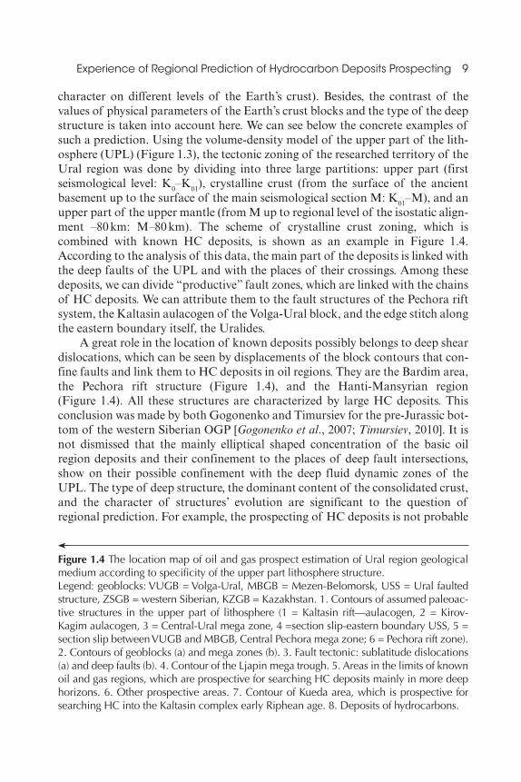
character on different levels of the Earth’s crust). Besides, the contrast of the values of physical parameters of the Earth’s crust blocks and the type of the deep structure is taken into account here. We can see below the concrete examples of such a prediction. Using the volume‐density model of the upper part of the lithosphere (UPL) (Figure 1.3), the tectonic zoning of the researched territory of the Ural region was done by dividing into three large partitions: upper part (first seismological level: K0–K01), crystalline crust (from the surface of the ancient basement up to the surface of the main seismological section M: K01–M), and an upper part of the upper mantle (from M up to regional level of the isostatic alignment –80 km: M–80 km). The scheme of crystalline crust zoning, which is combined with known HC deposits, is shown as an example in Figure 1.4. According to the analysis of this data, the main part of the deposits is linked with the deep faults of the UPL and with the places of their crossings. Among these deposits, we can divide “productive” fault zones, which are linked with the chains of HC deposits. We can attribute them to the fault structures of the Pechora rift system, the Kaltasin aulacogen of the Volga‐Ural block, and the edge stitch along the eastern boundary itself, the Uralides.
A great role in the location of known deposits possibly belongs to deep shear dislocations, which can be seen by displacements of the block contours that confine faults and link them to HC deposits in oil regions. They are the Bardim area, the Pechora rift structure (Figure 1.4), and the Hanti‐Mansyrian region (Figure 1.4). All these structures are characterized by large HC deposits. This conclusion was made by both Gogonenko and Timursiev for the pre‐Jurassic bottom of the western Siberian OGP [Gogonenko et al., 2007; Timursiev, 2010]. It is not dismissed that the mainly elliptical shaped concentration of the basic oil region deposits and their confinement to the places of deep fault intersections, show on their possible confinement with the deep fluid dynamic zones of the UPL. The type of deep structure, the dominant content of the consolidated crust, and the character of structures’ evolution are significant to the question of regional prediction. For example, the prospecting of HC deposits is not probable
Figure 1.4 The location map of oil and gas prospect estimation of Ural region geological medium according to specificity of the upper part lithosphere structure.Legend: geoblocks: VUGB = Volga‐Ural, MBGB = Mezen‐Belomorsk, USS = Ural faulted structure, ZSGB = western Siberian, KZGB = Kazakhstan. 1. Contours of assumed paleoac-tive structures in the upper part of lithosphere (1 = Kaltasin rift—aulacogen, 2 = Kirov‐Kagim aulacogen, 3 = Central‐Ural mega zone, 4 =section slip‐eastern boundary USS, 5 = section slip between VUGB and MBGB, Central Pechora mega zone; 6 = Pechora rift zone). 2. Contours of geoblocks (a) and mega zones (b). 3. Fault tectonic: sublatitude dislocations (a) and deep faults (b). 4. Contour of the Ljapin mega trough. 5. Areas in the limits of known oil and gas regions, which are prospective for searching HC deposits mainly in more deep horizons. 6. Other prospective areas. 7. Contour of Kueda area, which is prospective for searching HC into the Kaltasin complex early Riphean age. 8. Deposits of hydrocarbons.
0002899007.indd 9 2/1/2017 3:56:10 PM
10 Oil and Gas Exploration: Methods and Application
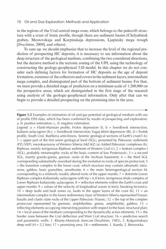
in the regions of the Ural central mega zone, which belongs to the paleorift structure with a crust of femic profile, though there are sediment basins (Chelyabinsk graben, Mostovskaja and Karpinskaja depressions, Ljapinsky mega trough [Druzhinin, 2009], and others).
To sum up, we should emphasize that to increase the level of the regional prediction of prospecting HC deposits, it is necessary to use information about the deep structure of the geological medium, combining the two considered directions, but the decisive method is the tectonic zoning of the UPL using the technology of constructing the geology‐geophysical 3‐D model. In this chapter we do not consider such defining factors for formation of HC deposits as the age of deposit formation, existence of the collectors and covers in the sediment layers, intermediate mega complex, and disintegrated part of the bottom of sediment basins. For that, we must provide a detailed stage of prediction on a minimum scale of 1:200,000 on the prospective areas, which are distinguished in the first stage of the research using analysis of the geologic‐geophysical information. Only after that can we begin to provide a detailed prospecting on the promising sites in the area.
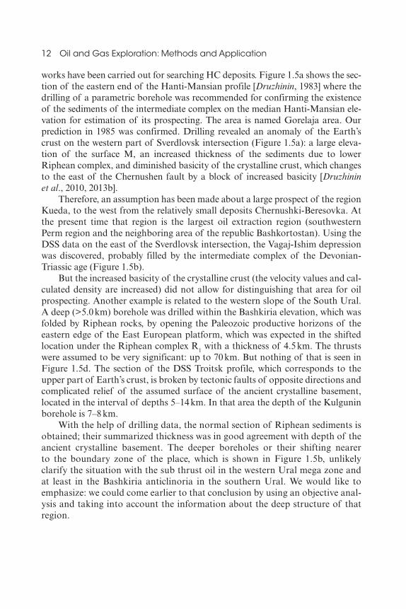
Figure 1.5 Examples of estimation of oil and gas potential of geological medium with use of profile DSS data, which has been confirmed by results of prospecting and exploration: a, b: positive estimation; c, d: negative estimation.Legend: a = Hanti‐Mansian profile, Frolov depression (I), b = Sverdlovsk intersection, Kaltasin avlacogene (II),c = Sverdlovsk intersection, Vagaj‐Ishim depression (III), d = Troitsk profile, South Ural, Bashkiria anticlinoria. Seismic geological sections of Earth’s crust(1‐6): 1 = upper part of the first seism geological level (SGL), presented by Paleozoic sediments (PZ) (VEP); mezokaynozoy of Western Siberia (MZ‐KZ) (a); folded Paleozoic complexes (b); Riphean, mainly terrigenous Riphean sediments of Western Ural (c); 2 = bottom complex I (SGL), probably metamorphic rocks of the basic content of low Proterozoic; 3 = a second SGL, mainly granite‐gneiss, gneissic rocks of the Archean basement; 4 = the third SGL corresponding substantially reworked during the evolution to rocks of species protocrust; 5 = the transition complex in the lower crust, which structure may contain ultramafic intru-sions, gabbro, basic granulites, anorthosite; 6 = the main Seismogeological section M, corresponding to a relatively weakly altered rocks of the upper mantle; 7 = dolomite Lower Riphean complex Kaltasinsky aulacogene with Vp = 6,8 km/s; terrigenous shale complex of Lower Riphean Kaltasinsky aulacogene; 8 = reflective elements within the Earth’s crust and upper mantle; 9 = values of the velocity of longitudinal waves in km/s; breaking tectonics: 10 = deep faults and fault zones (a), faults in the upper layers of the crust (b); 11 = an intermediate complex in the lower sedimentary layer of Western Siberia represented Triassic basalts and clastic‐slate rocks of the Upper Paleozoic‐Triassic; 12 = the top of the complex protocrust represented by gneisses, amphibolites, gneiss, amphibolite, gabbro; 13 = reflecting elements occupying intersecting position with respect to the basic structural plan; 14 = local areas of the medium corresponding to the dynamically active elements; 15 = the border zone between the Ural deflection and West Ural structure; 16 = predictive search and parametric wells: 1. Khanty‐Mansiysk (forecast Druzhinin, 1983), 2. Kulguninskaya deep well (H = 5.2 km); 17 = promising area; 18 = settlements: 1. Kueda, 2. Berezovka.
0002899007.indd 10 2/1/2017 3:56:10 PM

Experience of Regional Prediction of Hydrocarbon Deposits Prospecting 11
1.4. Discussion of the Results
1.4.1. Estimation of Oil Gas Prospecting by Profile Works
As a confirmation of the role of deep factors, in Figure 1.5a, b we have shown the seismological sections for the places of the DSS profiles, on which subsequently, independent from given recommendations, geological and geophysical
(a)
(c)
(d)
1
11 12 13 14 15 16109
H, km
H, km
H, km H, km
H, km
0
050
60 60
50
40
30
20
10
0
60
50
40
30
20
10
0
H, kmH, km
60
50
40
30
20
10
0
50
40
30
20
10
0
60
50
40
30
20
10
0
60
50
40
30
20
10
0
0 500 1000
MZ
1 1500 2 20006,8
3500 4000 4500 5000
III
MZ–KZ68°
53° 54°
68° 69°1
I
II
70°
55° 56° 57°
69° 70°
[ ]100 2 150
0
10
20
10
20
10 20 30 40 km H, km
2 3 4 5 6 7 8
1817
(b)
0002899007.indd 11 2/1/2017 3:56:10 PM
12 Oil and Gas Exploration: Methods and Application
works have been carried out for searching HC deposits. Figure 1.5a shows the section of the eastern end of the Hanti‐Mansian profile [Druzhinin, 1983] where the drilling of a parametric borehole was recommended for confirming the existence of the sediments of the intermediate complex on the median Hanti‐Mansian elevation for estimation of its prospecting. The area is named Gorelaja area. Our prediction in 1985 was confirmed. Drilling revealed an anomaly of the Earth’s crust on the western part of Sverdlovsk intersection (Figure 1.5a): a large elevation of the surface M, an increased thickness of the sediments due to lower Riphean complex, and diminished basicity of the crystalline crust, which changes to the east of the Chernushen fault by a block of increased basicity [Druzhinin et al., 2010, 2013b].
Therefore, an assumption has been made about a large prospect of the region Kueda, to the west from the relatively small deposits Chernushki‐Beresovka. At the present time that region is the largest oil extraction region (southwestern Perm region and the neighboring area of the republic Bashkortostan). Using the DSS data on the east of the Sverdlovsk intersection, the Vagaj‐Ishim depression was discovered, probably filled by the intermediate complex of the Devonian‐Triassic age (Figure 1.5b).
But the increased basicity of the crystalline crust (the velocity values and calculated density are increased) did not allow for distinguishing that area for oil prospecting. Another example is related to the western slope of the South Ural. A deep (>5.0 km) borehole was drilled within the Bashkiria elevation, which was folded by Riphean rocks, by opening the Paleozoic productive horizons of the eastern edge of the East European platform, which was expected in the shifted location under the Riphean complex R1 with a thickness of 4.5 km. The thrusts were assumed to be very significant: up to 70 km. But nothing of that is seen in Figure 1.5d. The section of the DSS Troitsk profile, which corresponds to the upper part of Earth’s crust, is broken by tectonic faults of opposite directions and complicated relief of the assumed surface of the ancient crystalline basement, located in the interval of depths 5–14 km. In that area the depth of the Kulgunin borehole is 7–8 km.
With the help of drilling data, the normal section of Riphean sediments is obtained; their summarized thickness was in good agreement with depth of the ancient crystalline basement. The deeper boreholes or their shifting nearer to the boundary zone of the place, which is shown in Figure 1.5b, unlikely clarify the situation with the sub thrust oil in the western Ural mega zone and at least in the Bashkiria anticlinoria in the southern Ural. We would like to emphasize: we could come earlier to that conclusion by using an objective analysis and taking into account the information about the deep structure of that region.
0002899007.indd 12 2/1/2017 3:56:10 PM
Experience of Regional Prediction of Hydrocarbon Deposits Prospecting 13
1.4.2. Estimation of Oil and Gas Prospecting of Geological Medium of Main Oil and Gas Provinces and Area of the Ural Region on the Basis of Obtained Information and Revealed Depth Criteria
1.4.2.1. Timan and Pechora Oil and Gas Province (northwest part, Figure 1.4), Limited on the East by 62° and on the South by 62° of Northern Latitude
For this area, the perspectives of oil and gas prospecting had been extended due to the western mega block; a chain of prospective places is located along the contact (deep fault) Izma‐Pechora block with the Omra‐Luzkaja rift zone. The promising areas are located on the intersection of longitudinal faults with the sublatitudinal dislocations and diagonal faults. In the limits of the Pechora mega block, a number of areas have been mainly outlined for prospecting deposits in deep horizons. The perspectives of the eastern mega block (Chernishevskiy and Rogovo‐Kosvinskiy) are not finally distinguished. We had to take into account the analysis of the oil‐ and gas‐promising Pechora mega block features, that the activity of dynamic processes, which are linked with the origin of the rift system, were continued in Trias (basalts effusion), the Neokomian reversal of the structural plan from a north‐northwestern to north‐northeastern direction, which led to shear dislocations. Probably the activity of the Pechora mega structure is saved on the current stage, which is a positive moment by the estimation of perceptiveness of that structure.
1.4.2.2. The Eastern Part of the Volga‐Ural Oil and Gas Province of the East European
Platform, (the south‐eastern part, limited on the east by meridian value of 58°, Figure 1.4)
The most promising region, according to information of the deep structure, is the Kueda region—the southwestern part of the Perm territory (Figure 1.6a). It is located in the limits of an assumed deep fluid dynamical zone, which was formed at the intersection of deep diagonal faults and which is probably accompanied by shear dislocations. In geological plane to the Paleozoic sedimentary cover to that region, the articulation of the Kaltasin aulacogen and the Kama‐Carnelian trough is located. In their limits, the lower Riphean dolomites can contain oil, which are located on relatively not large depths of 2.5–2.7 km. Due to a significant fracturing of certain areas, which tend to deep faults, the existence of a fractured reservoir is not excluded. The relatively smaller depth of dolomite strata on the southwestern side of the Perm territory and on the northern side of the Bashkiria Republic can significantly facilitate the prospecting of such type of deposits. The dolomite sediments can also be promising in that region. The promising areas are
0002899007.indd 13 2/1/2017 3:56:10 PM

14 Oil and Gas Exploration: Methods and Application
outlined outside the borders of the contour shown in Figures 1.4 and 1.6, and they can be located in the limits of the considered net of deep orthogonal faults.
1.4.2.3. The Northern Part of the Perm TerritoryThe prospect of the northern part of the Perm territory is not significant,
because according to the scheme of tectonic zoning (Figure 1.4), it is located in
0
1 2 3 4
5 6 7 8a b
1
20 40 60 80 km
Figure 1.6 Scheme of potential oil and gas surveys of low Riphean complexes, located in the southwestern Perm territory (Bardim area).Legend: Blocks of the Earth’s crust: IGB = Izhevsk, NKB = Nizhniy‐Kamskiy, VKB = Votkinskiy, KUB = Kuedinskiy, PRB = Permskiy, BKB = Bimsko‐Kungurskiy, BSHB = Bashkiria, SS = Sarapul‐structure. Boundaries of potential prospecting areas: 1. Kueda; 2. Sarapul‐structure and Izhevsk‐block, disjunctive tectonics; 3. Sublatitude boundary zones; 4. Subvertical faults; 5. Elements of shear tectonics; 6. Border areas; 7. Known oil deposits [Neganov, 2010]; 8. Prospecting areas (1–4) for arranging detailed research of the first stage (a) and next stage (b).
0002899007.indd 14 2/1/2017 3:56:11 PM

Experience of Regional Prediction of Hydrocarbon Deposits Prospecting 15
the lower Proterozoic folded complexes of mafic profile, which are analogous to the karelides of the Baltic shield. The interest of HC processing was shifted to certain areas of the Kazim aulacogen and sublatitude dislocation in the region of the 61st parallel. The region of intersection has to be classified into three large structures of the Ural region: Volga‐Ural, Timan‐Pechora, and the Ural folded system. Besides, the Paleozoic complexes here can be as pre‐Paleozoic oil saturated sediments. The prospects of the top‐folded zone of the western Urals slope are limited, excepting two or three areas, which coincide with “pockets” that are formed by fault‐slip dislocations. That region of the Sabik area is defined as promising according to results of generalization of deep seismic soundings data and constructing of the geological‐geophysical volume model for the Shalja‐Mihailov area [Druzhinin et al., 2004].
1.4.2.4. Results of Parametric Drilling on the East UralAccording to parametric drilling in 2011 in the east Ural, a significant
amount of gas was determined in the productive eastern part of the East European platform carbon horizons, which has here an increasing thickness, compared with other regions of the eastern part of the Pre‐Ural trough. The same situation can be also similar to the north areas. The suggestion about the small promise of the top‐folded zone is contrary to known results about a high promise of that territory. To support the thesis with another example from the south Ural, let us indicate two characteristic features of the western slope of the Ural: first, the large plates, which were created by horizontal movements, are absent or poorly developed—they are mainly shifted structures with small horizontal amplitudes; second, the geological medium of the western Ural mega zone as a compound part of the Ural folded system has a complicated structure and has, especially the eastern part, a mainly metallogenic potential.
1.4.2.5. Oil and Gas Province of the Western (Pre‐Ural) Area (Western Siberia) (Figure 1.4)
The southern segment of the western Pre‐Ural is the most promising; its geological medium contains significant oil and gas potential, indicated by the existence of many super large, large, and middle HC deposits. This promising band, which has been defined and which contains no fewer than 10 areas, coincides with the boundary seam and Hanti‐Mansian and Nadym ancient massif of the western Siberian geo block. The method of prediction was the same, as for the Timan‐Pechora oil and gas province. By defining the prospect areas, we took into account the probable confidents of yet known deposits to probable deep shear dislocations, especially significant in the limits of the Hanti‐Mansian mega block. Some areas are defined behind the limits of the oil regions, but the main part is revealed in these regions and oriented mainly for searching HC deposits in the intermediate complex and in the disintegrated part of the bottom of the sedimentary basin. To the south of the 60th parallel on the continuation of the band, some prospective areas have been revealed. The prospects of the eastern Ural mega zone and the eastern part of
0002899007.indd 15 2/1/2017 3:56:11 PM

16 Oil and Gas Exploration: Methods and Application
the central Ural mega zone (SUMZ) are limited in spite of the existence in the northern part of sufficient thicknesses of sediments of the Mesozoic‐Cenozoic age (more than 1–1.5 km). The high prospect of the Ljapinsky trough, which is assumed without considering the specificity of Earth’s crust structure, was not confirmed by further geological‐geophysical works. It had not been taken into account the conclusions about the small potential of that structure, which had been made by providing DSS, profile Verchnenildino‐Kizim in 1986 and then by constructing the volume geological‐geophysical model UPL for the northwestern part of the eastern Siberian plane [Druzhinin, 2009]. As reciprocally prospect areas, some areas have been defined along the east contact of the SUMZ in the limits of the neighbor strip of elevations of the eastern Ural mega zone (Figure 1.6). Here we do not give information about the areas’ surveys, which are confined to a granite massif of upper Perm age, which is given in Druzhinin et al. [2014].
1.5. Conclusions
The new technology of regional prediction of hydrocarbon fields and the solution of tectonic problems of regional oil and gas geology on the basis of lithosphere upper structure information is offered. We forecasted more than 10 prospective sites for statement of detailed exploration. This technology concerns immersed deposits in known oil areas and focuses on new areas. Positive results of good orientation exploration will lead to a significant increase in the resource base of hydrocarbons in the oil and gas provinces of the Ural region. Research on the creation of geologic‐geophysical models developed at the Institute of Geophysics UB RAS needs to be continued. Research should focus on all territory of the western Siberian platform and Timan‐Pechora OGP, including the Pechora Sea; other areas include earlier Phanerozoic and Paleozoic complexes, and perhaps productive deposits of the western slope of the Urals and regions of granite massifs. It is important to increase reliability and detailed information on deep structures through interpreting results on regional profiles of deep OGP, expanding geophysical methods, and obtaining data on superdeep drilling. For promising areas, it is necessary to perform additional analysis of the obtained information together with geological and geophysical data on the near‐surface structures with participation of experts for each province.
References
Bembel, S., V. Megerja, et al. (2006), Prospecting and exploration of hydrocarbons on the basis of the concept geosoliton degassing of the Earth. Geology of Oil and Gas, 2, 2–29 (in Russian).
Bulin, N., et al. (2000), Prediction of oil petroleum potential according to deep seismic profiles. Regional Geology and Metallogeny, 10, 195–204 (in Russian).
0002899007.indd 16 2/1/2017 3:56:11 PM

Experience of Regional Prediction of Hydrocarbon Deposits Prospecting 17
Bochkarev, V., and A. Brechuntsov (2008), Generalized tectonic models of the west‐Siberian geosynclines. Gornie Vedomosti, 3, 6–23 (in Russian).
Dmitrievskiy, A. (2009), Selected Works, Vol. 2. Fundamental problems of Earth’s sciences. Nauka, Moscow (in Russian).
Dmitrievsky, A., and B. Valyaev (eds.) (2012), Degassing of the Earth and the Genesis of Oil and Gas Fields. Geos, Moscow (in Russian).
Dontsov, V., and A. Lukin (2006), About endogen factors of oil deposits forming into the crystalline basement of Kiulongian depression into the shelf of South Vietnam. DAN, 11,10–18 (in Russian).
Druzhinin, V. (1978), Characteristics of the Ural deep faults according to seismic data. Soviet Geology, 4, 146–154 (in Russian).
Druzhinin, V. (1983), The features of the deep structure of West‐Siberian plate along the Hanti‐Mansian DSS profile. Geology and Geophysics, 4, 39–45, (in Russian).
Druzhinin, V. (2009), Information of Earth’s crust structure is necessary attribute of regional oil geology (according to the example of Ural region). Russian Geology, 6, 65–70 (in Russian).
Druzhinin, V., V. Kolmogorova, et al. (2009), The map of pre‐Yurian matter complexes in the northwestern part of western Siberian plain on the base of the volume model of the Earth’s crust, Russian Geology, 1, 104–112, (in Russian).
Druzhinin, V., P. Martyshko, et al. (2012), Solution of the problems of regional oil geology of the middle segment of the Ural region on the base of volume geological‐geophysical model of the upper part of lithosphere. Geology, Geophysics and Exploration of Oil and Gas Deposits, 1, 32–41 (in Russian).
Druzhinin, V., P. Martyshko, et al. (2013a), The scheme of tectonic zoning of the Ural region on the base of information about the structure of the upper part of lithosphere. Russian Geology, 1, 43–58 (in Russian).
Druzhinin, V., P. Martyshko, et al. (2013b), Regional structural features of Lower Riphean sections in connection with the problem of petroleum resource potential of deeply buried complexes in the southwestern Perm region, Doklady Academia Nauk, 452 (2), 181–184.
Druzhinin, V., P. Martyshko, et al. (2014a), Structure of the Upper Part of the Lithosphere and the Oil Petroleum Potential of the Ural Region. IGF UB RAS, Ekaterinburg, (in Russian).
Druzhinin, V., N. Nachapkin, and V. Osipov (2010), The role of information about the structure of the Earth’s crust for tectonic zoning and estimation of oil prospecting of new regions and new objects. Geology, geophysics and exploration of oil and gas deposits, 11, 10–18 (in Russian).
Druzhinin, V., V. Osipov, and A. Pervushin (2004), About HC searching in the southwestern part of the Sverdlovsk region. Prospecting and Protection of Natural Resources, 2, 29–30 (in Russian).
Druzhinin, V., V. Rakitov, et al. (2014b), Crustal structure in the Polar sector of the Urals folded system (from DSS data). Russian Geology and Geophysics, 55, 390–396.
Druzhinin, V., I. Sobolev, and V. Ribalka (1976), The Link of Tectonics and Magmatism With the Deep Structure of the Middle Ural According to DSS data. Nedra, Moscow (in Russian).
Gogonenko, G., A. Kashin, and A. Timursiev (2007), Horizontal basement shifting of western Siberia, Geology of Oil and Gas, 3, 3–11 (in Russian).
0002899007.indd 17 2/1/2017 3:56:11 PM
18 Oil and Gas Exploration: Methods and Application
Martyshko, P., V. Druzhinin, et al. (2011), Method and results of volume geological‐geophysical model development of the lithosphere upper part of the northern and middle segments of the Ural region. In Dynamics of the Earth’s Physical Fields. IPHE RAS, Moscow, pp. 9–30 (in Russian).
Megerja, V. (2009), Search and Exploration of HC Deposits, Which Are Controlled by Geosoliton Degassing of the Earth. Locus Standy, Moscow (in Russian).
Neganov, V. (2010), Seismological Interpretation of Geophysical Materials on the Middle Urals Region and Prospects of Further Petroleum Investigations. Perm University, Perm (in Russian).
Timonin, N. (1998), Pechora plate: History of geological evolution in the Phanerozoic. Institute of Geology Komi Scientific Center UB RAS, Ekaterinburg (in Russian).
Timursiev, A. (2010). The modern state of practice and methodology of searching oil: From misconception stagnation to new ideology of progress. Geology, Geophysics and Exploration of Oil and Gas Deposits, 11, 20–32 (in Russian).
0002899007.indd 18 2/1/2017 3:56:11 PM