1. EXECUTIVE SUMMARYAs per Rajasthan State Pollution Control Board (RSPCB) vide letter no. CD & SCMG...
25
1. EXECUTIVE SUMMARY Particulars Details Project Name & Location Masonry Stone & Crushing Mining Project (ML No.- 114/95, M L area – 6918.75 M2 (0.6918 hectare) )Near village- Todi Di Puriya, Tehsil- Amer, District- Jaipur, Rajasthan Latitude 27 0 02’04.52” to 27 0 02’05.35” N Longitude 75 0 47’03.70” to 75 0 46’59.82”E Toposheet No. 45M/16 Total Mining area 6918.75 M 2 (0.6918 hectare) Mineable Reserves 371058.17 MT Capacity Production of mine- 157364TPA of Masonry Stone Production Capacity of Crusher-500 TPD named M/s Shree Shyam Associates Life of Mine 4.1 year Ultimate depth of mining 455 mRL Estimated project cost 70 Lac. EMP Cost 0.50 Lac / annum Power Requirement Power facility are available in the village itself but power line is not required at present in the Mining Area. There is also an electric connection to operating the crusher plant. Fuel Requirement 0.5 KLD (HSD) DG Set As per requirement. Highest and Lowest Elevation S. No. Particulars Elevation (mRL) 1. Highest 496 2. Lowest 466 Land use Govt.Waste land Nearest Habitation/ Town The village Todi Di Puriya, nearest population center is about 0.93 km from the ML area. Nearest Airport Airport – Jaipur at a distance of 23 km from the ML area. Nearest Highway NH -11, about 1.5 km in W direction from ML area. SH -19, about 3 km in SSW direction from ML area. Nearest Railway Station Nearest Railway Station is Jaipur railway station at a distance of 13 km from the ML area. Power Supply The village Todi Di Puriya, nearest population center is about 0.93 km from the ML area. Nearest Telephone The village Todi Di Puriya, nearest population center is about 0.93 km from the ML area. Nearest Dispensary and Govt. Hospital The village Todi Di Puriya, nearest population center is about 0.93 km from the ML area. Educational Facility The village Todi Di Puriya, nearest population center is about 0.93 km from the ML area. Water Demand and Supply 4.00 KLD Nearest Tourist Places None within the study area Defense Installations None within the study area Archeological Features None within the study area Ecological Sensitive Zones Nearest Streams/ Rivers/ Water Bodies (from mine boundary) Seismic Zone Seismic zone – II
Transcript of 1. EXECUTIVE SUMMARYAs per Rajasthan State Pollution Control Board (RSPCB) vide letter no. CD & SCMG...

1. EXECUTIVE SUMMARY
Particulars Details
Project Name & Location Masonry Stone & Crushing Mining Project
(ML No.- 114/95, M L area – 6918.75 M2 (0.6918 hectare)
)Near village- Todi Di Puriya, Tehsil- Amer, District- Jaipur,
Rajasthan
Latitude 27002’04.52” to 27002’05.35” N
Longitude 75047’03.70” to 75046’59.82”E
Toposheet No. 45M/16
Total Mining area 6918.75 M2 (0.6918 hectare)
Mineable Reserves 371058.17 MT
Capacity Production of mine- 157364TPA of Masonry Stone
Production Capacity of Crusher-500 TPD named M/s Shree Shyam
Associates
Life of Mine 4.1 year
Ultimate depth of mining 455 mRL
Estimated project cost 70 Lac.
EMP Cost 0.50 Lac / annum
Power Requirement
Power facility are available in the village itself but power line is
not required at present in the Mining Area. There is also an electric
connection to operating the crusher plant.
Fuel Requirement 0.5 KLD (HSD)
DG Set As per requirement.
Highest and Lowest Elevation
S. No. Particulars Elevation (mRL)
1. Highest 496
2. Lowest 466
Land use Govt.Waste land
Nearest Habitation/ Town The village Todi Di Puriya, nearest population center is about
0.93 km from the ML area.
Nearest Airport Airport – Jaipur at a distance of 23 km from the ML area.
Nearest Highway NH -11, about 1.5 km in W direction from ML area.
SH -19, about 3 km in SSW direction from ML area.
Nearest Railway Station Nearest Railway Station is Jaipur railway station at a distance of
13 km from the ML area.
Power Supply The village Todi Di Puriya, nearest population center is about
0.93 km from the ML area.
Nearest Telephone The village Todi Di Puriya, nearest population center is about
0.93 km from the ML area.
Nearest Dispensary and Govt.
Hospital
The village Todi Di Puriya, nearest population center is about
0.93 km from the ML area.
Educational Facility The village Todi Di Puriya, nearest population center is about
0.93 km from the ML area.
Water Demand and Supply 4.00 KLD
Nearest Tourist Places None within the study area
Defense Installations None within the study area
Archeological Features None within the study area
Ecological Sensitive Zones
Nearest Streams/ Rivers/ Water
Bodies (from mine boundary)
Seismic Zone Seismic zone – II

2. INTRODUCTION OF PROJECT /BACKGROUND INFORMATION
Environment Clearance has been already obtained for Masonry Stone Mines M.
L. No. 114/95 over an area 6918.75 M2 (0.6918 hectare) near village – Todi Di
Puriya, Tehsil- Amer, District Jaipur (Raj.) by DEIAA vide EC letter no.
DEIAA/JAIPUR/EC/2016/3614 on dated 14/10/2016 for the production of 90000
TPA.
As per Rajasthan State Pollution Control Board (RSPCB) vide letter no. CD &
SCMG (Gen-03)/RSPCB/1235 to1271, Dated 24.01.2017 we are applying for
Environment Clearance for inclusion of Crusher Plant in EC.
The Modified Mining Scheme for Masonry stone & crusher Plant (M.L. 114/95)
over an area of 6918.75 M2 (0.6918 hectare), Near village – Todi Di Puriya,
Tehsil- Amer, District Jaipur (Raj.), approved by vide letter no. …………………by
SME Jaipur.
The mining lease area (ML Area – 6918.75 M2 (0.6918 hectare) ML No. – 114/95,
Mineral- masonry stone), near village – Todi Di Puriya, Tehsil- Amer & District
– Jaipur, (Rajasthan) was granted in favor of Shri Kaluram Gujar S/o Shri
Panchuram Gujar Village- Jagannathpura, Post – Nangal Purohitan, Tehsil-
Amer, District-Jaipur (Raj.) vide letter no. ME/JAI/CC-3/M.L 114/95R/1409
dated 23/10/1996 for 20 years from the date of registration 01/03/1996.
(01/03/1996 to 28/02/2016).
The lease was transferred Shri. Ghanshyam Singh, S/o Shri Chawand Dan
Singh, R/o – Plot No. 02, Path No.7, New Karni Colony, Murlipura, Jaipur (Raj.),
vide letter no. ME/JAI/CC-3/M.L 114/95R/1 dated 26/08/2002.
The lease period was extended 20 to 30 years by vide order no. ME/JAI/CC-4/M.L
114/95R/281 dated 26.02.2013 for 30 years from the date of registration
01/03/1996. (01/03/1996 to 28/02/2026).
Further the lease was transferred M/s. Shri Shyam Associates, Village – Todi Di
Puriya, Tehsil- Amer & District – Jaipur, (Raj.) by vide letter no. ME/JAI/CC-
3/M.L.114/95/R/178 on dated 29.01.2015 for 6918.75 m2 (0.6918 hectare) area for
Mineral- Masonry Stone, for 30 years from the date of registration 01.03.1996.
(01/03/1996 to 28/02/2026).

Refer Annexure No. II: Copy of Grant Order & Lease Deed
Refer Annexure No. III: Copy of Lease Area map, Demarcation Report
Refer Annexure No. IV: Copy of Khasra Map & Jamabandi
The mining lease area is 6918.75 M2 (0.6918 hectare) covering part of GT sheet
no. 45M/16 near Village – Todi Di Puriya, Tehsil - Amer & District – Jaipur
(Rajasthan).
2.1 Identification of the project and project proponent
Name of the Project : Masonry Stone & Crushing Mining Project
Location : Near Village – Todi Di Puriya,
Tehsil : Amer
District : Jaipur, Rajasthan
Proposed Production of Mine : 157364 TPA of Masonry Stone
Production Capacity of Crusher : 500 TPD named M/s Shree Shyam Associates
Mining Lease Area : 6918.75 M2 (0.6918 hectare) (Govt. waste Land)
Lessee Address
M/s. Shri Shyam Associates, Village – Todi Di Puriya, Tehsil-
Amer & District – Jaipur, (Raj.)
2.2 Brief description of the nature of the project:
It is a captive Mine of Masonry stone & Crusher plant is proposed in the mining
area 6918.75 M2 (0.6918 hectare), ML No. 114/95 (Govt. Waste Land), near
village – Todi Di Puriya, Tehsil - Amer & District – Jaipur, Rajasthan. Mining
is carried out by semi Mechanized Opencast method.
Masonry Stone to be mined out 157364 TPA & Capacity of Crusher 500 TPD.
Working will be systematic by forming proper benches. Mining operation carried
out by drilling in the stone, charging with explosive and blasting the hole. The
blasted material is loaded to dumper after proper sizing with the help of rock
breaker. The blasted material is fed to crusher for further preparation of
aggregates. The masonry stone is exposed in the lease area. The bench height
would not be kept greater than statutory provisions of the prevailing Act i.e. the
width of the benches should be more than the height of the bench, here in this
mining project the height of bench kept is 6m and width more than height.

2.3 Need for the project and its importance to the country and or region:
Due to globalization, the requirement for masonry stone has been on the rise over
the last few years. Mineral Masonry stone uses in various forms such as lumps &
grits. Mining Industry play an important role in economic sector in India. The
important benefits of the project to the state in form of royalty and can be stated
as boost to local and regional economy. The development of mining & Crusher
plant in the area provides direct & indirect employment opportunities, better
infrastructural facilities, communication and socio-economic infrastructure nearby
village.
2.4 Demands-supply gap:
Masonry Stone & Crushing material is used as basic building raw material in
construction of buildings and infrastructure projects, Due to rapid
Industrialization and urbanization demand of masonry stone is increasing,
Demand of stone in its various forms such as lumps & grits.
2.5 Imports vs. indigenous production
Demand of Masonry Stone in the domestic market is high, In the allotted area,
masonry stone is available in abundant quantity and can be excavated
indigenously. It had become a major source of economy in the area.
2.6 Export possibility
Mineral Masonry Stone shall cater the indigenous demand and major consumers
are located in nearby areas. No export will required.
2.7 Domestic/export markets
There is always an increasing demand of masonry stone in domestic market.
2.8 Employment generation (direct or indirect due to the project)
By this mining project of masonry stone in the area, people get employment.
The project directly generates the employment opportunities for the local
people and indirectly for the others. The total manpower requirement for

the proposed mining operation will be around 24 persons directly, Indirect
employment & 15 persons required for crusher staff.
Employment Potential
S.
No.
Designation Qualification Nos.
1 Mining Engineer/
Geologist (part time)
Approved by DMG, Rajasthan
and DGMS, Ajmer region
1
2 Mine Foreman Full time 1
3 Mining Mate-cum-
blaster
Mate’s competency certificate
holder
1
4 Time keeper cum store
keeper
Secondary 1
5 Labours Secondary / Middle school 20
Crusher Staff
S. No Designation Present Qualification
1 Site Manager 1 Graduate
2 Operator 4 Secondary
3 Labores 10
3.0 PROJECT DESCRIPTION
3.1 Type of project including interlinked and interdependent projects:
The proposed project of Masonry stone& Crusher plant in the mining lease area
of 6918.75 M2 (0.6918 hectare) situated at Near village – Todi Di Puriya, Tehsil -
Amer & District – Jaipur, Rajasthan. This project is producing 157364 TPA of
Masonry Stone & Capacity of Crusher 500 TPD.
This Mining project is interlinked with Crushing activity of the mineral , Mining
operation carried out by drilling in the stone, charging with explosive and
blasting the hole. The blasted material is loaded to dumper after proper sizing
with the help of rock breaker. The blasted material is fed to crusher for further
preparation of aggregates.
3.2 Location (Location map & Key plan is attached as Plate no. I & II
respectively).
State : Rajasthan
District : Jaipur
Tehsil : Amer
Near Village : Todi Di Puriya
The entire project area is 6918.75 M2 (0.6918 hectare) (Govt. Waste Land)
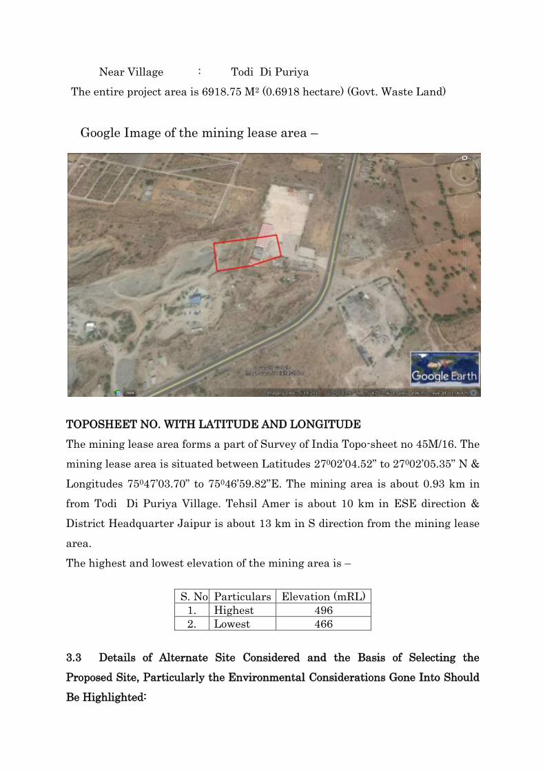
Google Image of the mining lease area –
TOPOSHEET NO. WITH LATITUDE AND LONGITUDE
The mining lease area forms a part of Survey of India Topo-sheet no 45M/16. The
mining lease area is situated between Latitudes 27002’04.52” to 27002’05.35” N &
Longitudes 75047’03.70” to 75046’59.82”E. The mining area is about 0.93 km in
from Todi Di Puriya Village. Tehsil Amer is about 10 km in ESE direction &
District Headquarter Jaipur is about 13 km in S direction from the mining lease
area.
The highest and lowest elevation of the mining area is –
S. No. Particulars Elevation (mRL)
1. Highest 496
2. Lowest 466
3.3 Details of Alternate Site Considered and the Basis of Selecting the
Proposed Site, Particularly the Environmental Considerations Gone Into Should
Be Highlighted:

Mining is site-specific project hence no alternate site is considered and Crusher
Plant situated in lease area.
3.4 Size/ Magnitude of Operation
It is proposed to produce 157364 TPA of Masonry Stone & Capacity of Crusher
500 TPD from the mining area of 6918.75 M2 (0.6918 hectare) by semi
mechanized open cast method of mining.
3.5 Project description with process details:
It is a captive mine project all minerals are feeding in crusher which situated
within lease area. The working in the area will be carried out by semi-
mechanized open cast method. The hydraulic machineries will be deployed time
to time as and when required. Considering the national, state and local holidays
there will be around 300 working days in a year. Proposed working will be
systematic by forming proper benches. Mining is done by drilling in the stone,
charging with explosive and blasting the hole. The blasted material is loaded to
dumper after proper sizing with the help of rock breaker. The blasted material
is loaded to dumper after proper sizing with the help of rock breaker. The
blasted material is fed to crusher for further preparation of aggregates. The
masonry stone is exposed in the lease area. The bench height would not be kept
greater than statutory provisions of the prevailing Act i.e. the width of the
benches should be more than the height of the bench, Here in this mining
project the height of bench kept is 6m and width more than height. The ultimate
pit size of the pit is mentioned below-
S. No. Particular Dimension in Meter
1 Length 70.12
2 Width 33.27
3 Depth 6.0
Blasting:
Drilling & Blasting
(i) Since the area is in the near vicinity of National Highway, drilling and
blasting may cause the damage to the N. H shot hole drilling of 32 mm dia.

Is proposed for fragmenting the rock as per requirement and blasting will
be done after taking permission from Director General of Mines Safety.
(ii) Rocks exposed in the area though it is hard and compact but highly joined
and fractured. It is proposed to use rock breaker to dislodge the exposed
rock.
Storage of Explosive: - The blasting shall be done daily. The explosive shall be
handled by contractor same as per the present practice. Hence, no storage of
explosive is proposed.
Precautions:
The mining is done on the hilly portion and though there is no human settlement
in the bottom of the hill, special precautions will have to be taken for fly rock
problem. All the adequate precautions as per provisions MMR 1961 will be
taken.
Individual bench slope will be 850. In the first five year, about 278 saplings will
be covered plantation along the lease boundary. On the above techno-economic as
well as environmental consideration, the conceptual mining plan has been drawn
keeping 52° ultimate pit slope angle.
Proposed Production & life of Mine
The proposed year wise production plan for next five years is given in table below
Year wise Annual production in Next Five Years
Year X- section Levels Overburden in m3 Run off mine Mineral in Tonne
In Tonne
X- section
area
Infl.
Length
volume Area
In m3
Infl.
Length
volume B.D. Tonnage
1st I P – I P’
2 P – 2 P’
490
490
- - - 582.30
581.23
23.5
21.5
13684.1
12496.4
2.8
2.8
38315.48
34990.05
Total 73305.53
2nd IP – IP’ 482 - - - 398.46 38.5 15340.7 2.8 42953.96
2 P – 2 P’ 484 595.09 29.5 17555.2 2.8 49154.56
Total 92108.52
3rd I P – I P’ 484
478
- - - 436.01
543.08
16.5
22.5
7194.16
12219.3
2.8
2.8
20143.65
34214.04
2 P – 2 P’ 478 476.79 18.5 8820.6 2.8 24697.68
Total 79055.37
4th IP – IP’ 472 - - - 472.02 15.5 7316.31 2.8 20485.67
2 P – 2 P’ 472 502.50 18.5 9296.25 2.8 26029.5
Total 46515.17

5th IP – IP’ 472 - - - 535.79 15.5 8304.75 2.8 23253.29
2 P – 2 P’ 472 541.44 22.5 12182. 2.8 34110.72
Total 157364.0
1
Production & life of Mine
Mineable Reserve =371058.17 MT
Life of Mine = 4.1 year
Source : Approved Modified Scheme of Mining
Equipment & Machineries:
Details of Machineries to be deployed for crushing activity
S. No Machine No’s Make
1 Crusher JAHW 1 Grish Plant / Oil Plant
Flow Chart showing Lease operation:
3.6 Raw material required along with estimated quantity, likely source,
marketing area of final products, mode of transport of raw material and finished
product:
Lease
Crushing
Transportation

No raw material is required during the mining process. The operation involved
excavation of masonry stone fed in crusher Plant for aggregates and then
directly transport it to the end users/ market in form of lumps & grit.
3.7 Resource optimization/ recycling and reuse envisaged in the project, if any,
should be briefly outlined.
In nature, mineral is in finite quantity and once the mineral depleted cannot be
replenished. Working will be done systematically to optimum utilization of
resources
3.8 Availability of water its source, energy/power requirement and source
The total water requirement for the project is estimated 4.0 KLD. Water for
mining operation (dust suppression) and for domestic & drinking purpose will be
supplied from PHED supply & bore well situated nearby village through water
tankers.
S. No. Purpose Total Requirement (KLD)
1 Dust suppression 2.5
2 Drinking & other purposes 1.0
3 Green belt 0.5
Total 4.00
Ground Water Table
Electricity is already available at the site. Fuel (HSD) will be obtained from
authorized public fuel station & about 0.5 KLD H.S.D. will be used in
machineries & Vehicles during mining operation.
55.0 mRL (411 m BGL) WATER TABLE
455.0 mRL (11 m BGL) ULTIMATE DEPTH
496.0 mRL HIGHEST CONTOUR
Proposed working will not intersect Ground
water table.
LOWEST CONTOUR 466.0 mRL

3.9 Quantity of wastes to be generated (liquid and solid) and scheme for their
management /disposal:
During mining operation, some fine rock fragments will be treated as waste dump
and will be stacked separately within the lease boundary and later will be used
for backfilling. The topsoil present in the area will be used for plantation.
Nature of Top soil
Available top soil is loamy found as thin layer on top as capping of 0.5 met.
thickness having more water retention capacity spread over an area of 6918.75
M2. 0 hectare of land sanctioned under mining lease, which required to be
removed from the area to touch the gritty soil having variable thickness of
6918.75 M2. to 1.5 met covering the total lease area. It is proposed to scrap 0.01
met thick soil and talus by using scrapper and stack it separately.
Nature of overburden waste rocks
0.5 meter thickness of the rock is of the nature of morrum to be removed to expose
mineral bed. The rate of generation every year is given in table no. 7.a however
summarized details are as mentioned below in table
Table
Year wise generation of Morrum
Overburden waste
S. No. Year Morrum O.B. waste in m3
1 1st Year 179.5 285.79
2 2nd Year 179.5 276.81
3 3rd Year 179.5 265.55
4 4th Year - 235.60
5 5th Year - 235.60
Total 538.5 1299.35
N.B.-5% of the above mentioned mineral waste will need to be accommodated temporarily
at the common dumping site be sold in the market in due course.
Site of Dumping
The site of dumping is a common site decided by the cluster president and other
members in consultation with district authorities. Since sub grade is not
generated during the period of advancement hence its separate stacking is
neither required nor proposed.

3.10 Schematic representations of the feasibility drawing which give
information of EIA purpose:
4.0 SITE ANALYSIS
4.1 Connectivity
Connectivity Details from Project Site:
S. No. Particulars Details
1. Road
Connectivity
The mining area is about 0.93 km in from Todi Di Puriya
Village. Tehsil Amer is about 10 km in ESE direction &
District Headquarter Jaipur is about 13 km in S direction
from the mining lease area.
2. Nearest
Highway
NH -11, about 1.5 km in W direction from ML area.
SH -19, about 3 km in SSW direction from ML area.
3.
Nearest
Railway
Station
Nearest Railway Station is Jaipur railway station at a
distance of 13 km from the ML area.
4. Nearest
Airport
The nearest civilian airport for regular commercial flights
is at Jaipur the road distance from the mining lease area
Application for
prior
Environmental
Clearance (Form
IM & Pre-
Feasibility Report
Presentation for
EC before DEAC
Environmental
Clearance
Commencement of
mining & Crushing
Operation
Compliance of EC
Condition
Submission of
Compliance
report to concern
authority
Corrective
measures to meet
the norms in EC,
if any

4.2 Land form, land use and land ownership
The mining lease area generally hilly. The highest elevation of the lease area is
496 mRL & lowest elevation of the area is 466 mRL.
4.3 Topography
The mining lease area of 6918.75 M2. hectare falls within Latitudes 27002’04.52”
to 27002’05.35” N & Longitudes 75047’03.70” to 75046’59.82”E. Topographical
(Surface) Plan has been prepared on a scale of 1:500. The mining lease area is
hilly area, highest elevation of the area is 496 mRL & lowest elevation of the
area is 466 mRL. The ultimate depth of mining will be up to 455 mRL. No other
perennial Nallah / water bodies exist in the core area.
4.4 Existing Land use Pattern
The mining lease area is Govt. Waste Land (6918.75 M2. hectare). There is no
village or hutments within the mining lease area. Existing land use pattern is
given as below:
Present Land use pattern (Hects.)
S. No. Land use Category Pre Operational Phase
1 Top Soil Dump --
2 Waste Dump (External) --
3 Excavation (Voids Only) 0.5344
4 Road --
5 Built Up Area --
6 Township Area --
7 Afforestation --
8 Reclamation (Backfilled) --
9 Mineral Storage --
10 Processing (Crushing) --
11 Undisturbed Area 0.1574
Total
6918.75 M2.
(0.6918 hect.)
is around 23 km.
Type of Land Area in Hectares
Govt.Waste Land 6918.75 M2.
Total 6918.75 M2.

4.5 Existing Infrastructure:
Temporary Infrastructure is available at the mine site. Site services as per
Mines Rules 1956 will be developed. First-Aid station with all necessary medical
facilities, Toilets as per the provisions of Mines Rules will be developed.
Regular medical checkup of the mine employees will be carried out as per the
provisions of Mines Rules 1956.
4.6 Soil classification:
Jaipur district is characterized by wide spectrum of landscapes including
hillocks, pediments, undulating fluvial plains, aeolian dune fields, ravines,
palaeo-channels etc. Structural hills (mainly in northern and northeastern parts)
trending NNE-SSW are generally composed of Delhi quartzite. Main peaks
include Jaigarh (648mamsl), Nahargarh (599mamsl), Manoharpura (747mamsl)
and Bichun (656mamsl). Pediments with thin to thick soil cover can be seen
around Dudu, Phagi and Chaksu forming flat gneissic outcrops. Undulating
plains of fluvial/ fluvial-aeolian origin forming landforms of river terraces,
floodplains and buried channels of various drainage systems dominate in the
district. Aeolian sand dunes are found mainly in western parts (Sambhar,
Jobner, Renwal area) which are a few metres to 10m high. Obstacle and shadow
dunes can also be seen in parts of the district in addition to ravine and badland
topography at places. The district area is drained by ephemeral rivers Banganga,
Bandi, Dhund, Mendha, Mashi, Sota and Sabi and their tributaries. Sota and
Sabi rivers in the northern part of district flow northeasterly while
southwesterly flowing Banganga river passes through Shahpura, Bairath and
Jamwa Ramgarh blocks and contribute water to the famous Ramgarh lake from
where it flows easterly to enter Dausa district. Mendha River in northwest
portion of the district merges with famous Sambhar lake whereas Mashi river in
the southwestern part flows easterly.
Soils in the district may be classified as:
Loamy sand to sandy loam
Sandy clay loam
Sandy clay

Wind blown sand
River sand
Source : CGWB Jaipur
4.7 Regional geology & local geology:
a) Regional geology:-
No regional geological study has been carried out during the present study. The
stratigraphy of the region of which Bilaunnchi constitute a part has been worked
out based on the limited traverses and the available literature. The regional
geological concept has been used while studying the local geology, mapping and
correlation of Red ochre ferruginous phyllites, quartzite and other associated
litho units.
The main rock formations found in the area are of older Delhi System of which
quartzite are conspicuous. All the Aravali being softer schist are covered under
Alluvium. The stratigraphic divisions of Delhi rocks in this area are made on the
basis of its litho-logical character of the rock, the sequence given by Dr. Heron
seems to be quite convincing which is given as under:-
Super group Group Lithounits
quaternary Alluvium and Aeolian sand
DE
LH
I
SU
PE
RG
RO
UP
Aja
bgarh
Gro
up
Massive Quartzite
Amphibolites / Amphibolitic Quartzite
Calcareous facies (Dolomite, limestone, marble, amphibolitic
limestone/ marble, etc)
Phyllite/quartz mica schist
Brecciated ferruginous Quartzite
……………………………………..Unconformity…………………………………….
Basement Gneissic Complex
b) Local geology:-
Very thin of alluvial and aeoline sand covers the hard massive quartzite and
ferruginous Brecciated quartzite found at the top of the hillock. The rock
exposure of the area is highly jointed and fractured. Minor folds and faults are
observed all along the joints and fracture zone of the deposit. These minor
structural disturbance created crushing effect o the deposit which cause to

softening of the hard quartzite mainly responsible for the generation of more
dust after grinding. The dust generated is being collected and sold in the market
in form of Bjari.
General Geological Setting of the area seems to be as mentioned below-
Recent to Sub Recent Alluvium or windblown Sand- 00.05 to 6918.75 M2. 0
meter
Hard Massive Quartzite, Ferruginous Brecciated Quartzite- 06918.75 M2. 0 to 30.0
meter
Phyllites- 6918.75 M2. meter to 1.5 meter along the joints and
fractures. Basement not exposed so far but there are indiction of BGC,S. As
mentioned above that the area is highly disturbed geologically.
Composition:- The most common mineralogical constituents of the rocks are
feldspars olivine basalt are olivine. In fine grained texture or glassy mass
prophyritic feldspar seen.
Texture:- Masonry stone is fine to glossy texture with porphyritic
Structure:- Vertical columnar joint structure.
Occurrence:- The Masonry stone occurs chiefly as shallow depth intrusion.
Color:- The color of Masonry Stone is Black and Dark Brown.
Origin:- The origin of the Masonry Stone is magmatic source.
4.8 Climatic details
The semi-arid district receives normal annual rainfall of 527mm (1901-71) while
average annual rainfall for the last 30 years (1977-2006) is 565mm. Annual
average rainfall during the period 2001 to 2010 has been 527mm (Table 3). Over
90% of total annual rainfall is received during monsoon. Total annual potential
evapotranspiration is 1744.7mm. The coefficient of variation is moderate at
32.6% indicating slightly unreliable pattern of rainfall. Though, Jaipur city has
experienced floods in 1981, the district is prone to drought spells as witnessed
during 1984 to 1989 and 1999 to 2002. Table: Annual Rainfall Data (2001-2010)
(mm).
Sr. No. BLOCK 2001 2002 2003 2004 2005 2006 2007 2008 2009 2010 Average
1 AMER 432.00 235.00 679.00 790.00 470.00 354.00 529.00 547.00 277.00 729.00 504.20
2 BASSI 401.00 201.00 647.00 590.00 634.00 293.00 487.00 578.00 344.80 933.00 510.88
3 DUDU 403.95 152.40 409.05 467.40 313.10 311.15 341.90 634.30 258.55 716.30 400.81
4 GOVINDGARH 503.80 214.00 581.00 296.00 306.00 209.00 323.00 424.00 268.00 735.00 385.98
5 JAMWA RAMGARH 373.00 341.00 1066.00 1061.00 980.00 460.00 673.50 1160.00 572.00 1042.00 772.85
6 JHOTWARA 426.80 222.40 511.00 807.00 408.60 335.00 521.00 572.00 306.00 653.00 476.28
7 KOTPUTLI 407.60 273.67 906.73 591.37 916.67 576.00 608.10 928.00 278.00 711.67 619.78
8 PHAGI 429.30 202.00 531.80 525.25 524.20 351.30 568.75 634.70 376.50 869.00 501.28
9 SAMBHAR 519.10 141.50 518.45 501.05 464.85 310.90 367.60 631.20 232.05 800.75 448.75
10 SANGANER 585.00 237.00 552.30 805.00 397.00 407.00 557.30 572.00 275.00 745.00 513.26
11 VIRATNAGAR 628.50 262.00 1065.00 489.50 976.00 465.50 454.00 969.50 344.00 922.00 657.60
Average 464.55 225.63 678.85 629.42 580.95 370.26 493.74 695.52 321.08 805.16 526.52
Source: CGWB Jaipur
4.9 Social Infrastructure
The infrastructure like toilets, first aid stations etc. will be developed at
mine site.
The nearest village is Todi Di Puriya, health & educational facilities (in
the form of sr.sec. schools) are available there.
Medical facilities, Primary Health Centre are there in the area, imparting
services, for advance medical facilities. In each village one health worker
has been appointed by the Govt. to provide primary health facilities.
Village people are availing drinking water facilities generally from the
hand pump, open well and tube well. The water supply is also supplied
through tanker in few villages. During summer scarcity of water has been
noticed.
Communication services like post office and telephones are available in
the nearby village. Some of the villagers are having mobile phones.
An occupational health unit will be organized and the proposed measures
will be adopted:
Pre & Periodical Medical Checkup program for all the workers.
Compulsory medical checkup program and first-aid box with necessary
equipment will be provided.
Training for workers regarding occupational hazards.
Safety equipment i.e. dusts mask, safety shoes, gloves etc.
5.0 PLANNING BRIEF
5.1 Planning concept
This Mining Project is producing 157364TPA of Masonry Stone & Capacity of
Crusher 500 TPD from the mining lease area, situated in Jaipur District of
Rajasthan.
5.2 Population projection
Man power requirement for mining is estimated to be 24 Nos. & 15 persons
required for crusher staff most of the employees will be recruited from
neighboring village depending upon the availability of skilled & unskilled people.
Migration of highly educated and skilled person will take place but it will be on
temporary basis. So there will no permanent migration of people, hence there
will be no population projection.
5.3 Land use Planning:
LAND: STAGE WISE LAND USE AND RECLAMATION AREA (Ha.)
S. No. Land use Category
Pre
Operational
Phase
Operational
Phase
Post
Operational
Phase
1 Top Soil Dump -- -- --
2 Waste Dump (External) -- -- -- --
3 Excavation (Voids Only) 0.5344 0.5115 0.4043*
4 Road -- 0.02 --
5 Built Up Area -- -- --
6 Township Area -- -- --
7 Afforestation -- 0.10 0.2775**
8 Reclamation (Backfilled) -- -- --
9 Mineral Storage -- -- --
10 Processing (Crushing) -- 0.02 0.01
11 Undisturbed Area 0.1574 0.0403 --
Total
6918.75 M2.
(0.6918
hect.)
6918.75
M2. (0.6918
hect.)
6918.75
M2. (0.6918
hect.)
*About 0.4043 hectare area will be used as water reservoir.
**About 0.33 hectare RE will be planted in lease area & out side lease
area (Govt. waste land, Forest land, Govt. School, Panchayat Samiti Etc.)

POST MINING LAND USE OF CORE ZONE WITH ENVIRONMENT
MANAGEMENT
S. No. Description
Land Use (In Ha.)
Plantation Water
Body
Public
Use Crushing Undisturbed Total
1 Top Soil Dump -- -- -- -- -- --
2 External Waste Dump --
-- -- -- --
3
(a) Excavation (Voids) -- 0.4043 -- -- -- 0.4043
(b) Excavation
(backfilled) -- -- -- -- -- --
4 Road -- -- -- -- -- --
5 Built Up Area --
-- -- -- --
6 Township Area -- -- -- -- -- --
7 Afforestation 0.2775 -- -- -- -- 0.2775
8 Mineral Storage -- -- -- -- -- --
9 Processing (Crushing)
0.01 0.01
10 Undisturbed Area -- -- -- -- -- --
Total 0.2775 0.4043 -- 0.01 --
6918.75
M2.
(0.6918
hect.)
5.4 Assessment of infrastructure demand (physical and social).
Temporary offices, rest shelters and stores will be provided in the mining lease
area. Specified first-aid box with all necessary facilities and clean drinking water
will be made available at the project site. Primary Health Centre, medical
facilities. Communication services like post office are made available at the are
also made available in the nearby village.
5.5 Facilities provided:
5.5.1 Infrastructure
Basic facilities available in nearby village and towns such as roads, power
supply, and water supply. Site is well connected with road and other
infrastructure facilities.
5.5.2 Landscaping and green belt development
It is proposed to plant a total no. 278 saplings in the post operational phase.
Year wise plantation is shown on the conceptual plan.

Requirements for Plants for Afforestation and Reclamation
Year
Onward area Waste dump
(outside)
Inside dump
(reclaimed
area)
Top Soil Dumps Total
Area
(Ha.)
No.
of Area
(Ha.)
No.
of
Trees
Area
(Ha.)
No. of
Trees
Area
(Ha.)
No.
of
Trees
Area
(Ha.)
No. of
Trees Trees
Existing -- -- -- -- -- -- -- -- -- --
I 0.02 20 -- -- -- -- -- -- 0.02 20
II 0.02 20 -- -- -- -- -- -- 0.02 20
III 0.02 20 -- -- -- -- -- -- 0.02 20
IV 0.02 20 -- -- -- -- -- -- 0.02 20
V 0.02 20 -- -- -- -- -- -- 0.02 20 VI year
Onwards 0.1775 178 -- -- -- -- -- -- 0.1775 178
Total 0.2775 278 -- -- -- -- -- -- 0.2775 278
Place of proposed plantation: The Plantation will be done at the following
places:-
1. Along the lease boundary.
A number of species will be planted suitable to climate conditions this area
of like Babul, Neem, Khejri, Kaner etc. In addition, forest officials will be
consulted for other suitable species. The afforested area will be encircled by a
boundary of local thorny bushes to protect it from cattle’s and regular
watering thrice/twice a week (except monsoon) and maturing as required will
be done.
Protection of Plants:
Following measures are proposed for protection of plants.
The expected rate survival is assumed at 80%. To improve the survival rate in
the adverse climate condition necessary consultation would be taken from the
Forest department. Proposed plantation area shall be fenced properly for
improving the survival rate. Plantation will be carried out in the lease area in
phased manner.
5.5.3 Health and safety system

During the opencast working, and allied activities, all the precautionary
measures shall be taken into account as per MMR 1961 and MCDR 1988 for
safety and security.
Following Safety & Security measures will be enforced;
Moving front of the lease area shall have temporary fencing.
Permanent fencing will be provided where lease area has reached the
ultimate pit limit.
Mine entrance will have a permanent check post and record shall be
maintained of all persons / vehicles entering the mine area.
Round the clock security arrangement shall be provided to prevent
inadvertent entry of persons.
Mitigation measures will be taken in respect to non - compliance.
Inspection of regular operation of Pollution Control Equipment.
Review of the safety practices being followed and additional safety
measures if necessary.
Identification of the unsafe conditions/ practices preventing in the shops
for elimination of hazard, if any.
Arrangement of training to develop safety awareness among all staffs of
the works.
Preparation of safety codes/ manuals of operations and will be distributed
to workers.
5.5.4 Disaster Management and risk assessment
In spite of following all the precautionary measures and following all safety
rules, regulations and procedures, in mining accidents cannot be ruled out
completely. The applicant will formulate a Disaster Management Plan with the
approval of DGMS. Following are the accidents which can take place in
mechanised opencast mining and measures proposed to be taken.
Fall of human beings or fall of machines from benches/ dumps/haul roads.
Due to drilling / blasting and handling of explosives.
Fire & Explosion in machinery
Emergency situation due to social reason such as public unrest, terrorism
etc.

Preventive Measures:
Creating berm on the side of benches./ haul roads of height greater than or
equal to ½ tyre radius. Minimum height of berm shall be 1.2 m and slope
450. Minimum clearance of 1.5 m will be maintained between outer tyre
and berm.
All provisions of MMR 1961, conditions imposed in permission for Deep
hole drilling and blasting and use of HEMM, and conditions of explosive
license will be followed.
Fire fighting equipment in the machinery/ workshop/ office will be
maintained. Persons will be trained in the use of fire fighting equipment
and mock rehearsal will be conducted.
Training of security personnel.
Procedures as laid down in Disaster Management Plan to be followed.
Training;
Persons will be trained in the following:
Knowledge of Chemicals and use of protective equipment.
Procedures for reporting emergencies.
Location and use of fire fighting equipment
Knowledge of alarm system and siren
Evacuation procedures.
Training in first aid as per Mines Rules 1955
Emergency Equipment & Facilities:
Mobiles.
Fire fighting equipments
Emergency medical supplies
Other protective equipment’s i.e. goggles, helmet, face shield, hand gloves,
safety belts, barricade tape.
First Aid station as per the provisions of Mines Rules 1955.

6. PROPOSED INFRASTRUCTURE
S. No. Particulars Details
1 Mining Lease Area 6918.75 M2.
2 Residential Area Not Applicable
3 Connectivity The mining area is about 0.93 km in from Todi Di
Puriya Village. Tehsil Amer is about 10 km in ESE
direction & District Headquarter Jaipur is about
13 km in S direction from the mining lease area.
NH -11, about 1.5 km in W direction from ML
area.
SH -19, about 3 km in SSW direction from ML
area.
Nearest Railway Station is Jaipur railway station
at a distance of 13 km from the ML area.
The nearest civilian airport for regular
commercial flights is at Jaipur the road
distance from the mining lease area is around
23 km.
4 Green Belt In the post operational phase about 278 saplings
will be planted. Plantation will be done along the
lease boundary.
5 Social
Infrastructure
Physical & Social Infrastructure is provided, and if
necessary, other facilities will be provided by the
Lessee.
6 Water Management 4.00 KLD, Source: PHED supply & bore wells
through water tankers.
7 Sewerage System Domestic waste water will be treated into septic
tanks followed via soak pit.
8 Industrial Waste
Management
No, Industrial waste will be generated from the
project.
9 Solid Waste
Management
The waste will be used in backfilling the mined out
area or dumped on his own land.
10 Power requirement Electricity is already available at the project site.
7. REHABILITATION & RESETTLEMENT PLAN
There is no human settlement within the mining area. No human settlement will
be disturbed due to the mining activity. So, no Rehabilitation and Resettlement
is proposed.

8. PROJECT SCHEDULE
8.1 Proposed schedule and approval for implementation
The proposed project will be continuing operate after getting the Environmental
Clearance from DEAC, Jaipur.
8.2 Project cost estimation
Estimated Project Cost for the proposed project is Rs. 70.00 Lacs.
(A) Capital investment/-
Site Facilities = Rs. 50,000/-
Machinery & Tools = Rs. 26,40,000/-
Crusher = Rs. 30,00,000/-
Financial Assurance = Rs. 2,00,000/-
Social fund & activities = Rs. 40,000/-
EMP Fund = Rs. 50,000/-
Miscellaneous = Rs. 10,20,000/-
Total cost = Rs. 70,00,000/-
(B) Operational cost-
The mineral will be mined out from the mining lease area, the cost of per ton
mining will be approx. Rs. 100/- per ton.
The cost of the crushing of per ton mineral will be approx. Rs. 180/- per ton. So
the total cost of extraction & crushing of the masonry stone will be Rs. 280/-per
ton.
8.3 ECONOMIC VIABILITY
The anticipated cost of mining is Rs. 100/- per ton. Average sale value is assumed
to be Rs. 150-170/- ton of Masonry stone.
The anticipated cost for crushing of mineral is Rs. 180/- per ton. Average sale
value is assumed to be Rs. 400-450/- ton of Masonry stone. Hence the project will
be viable.

9. ANALYSIS OF PROPOSAL
Project will create direct & indirect employment opportunities within the
surrounding region. Unit will use good faith efforts to employ local
people from the nearby villages depending upon the availability of
skilled & un-skilled manpower surrounding the project site.
In the proposed project would require significant workforce of non-
technical and technical persons. Migration of highly education and
skilled experience will result in increase of literacy in the surrounding
villages.
In addition, the proposed project shall enhance the prospects of
employment.
Assessment of the potential socioeconomic benefits during mining
focused primarily on work force requirements, acquisition of
supplies, and the temporary increased demand for services related to
the mining project like food, housing, communications, law enforcement,
medical care, local transportation etc. Due to these, additional revenue
to local suppliers for required products and services related to the
construction and operation phases of the project will generate.
Thus, mining activities will provide numerous new, although temporary,
work opportunities for both skilled and unskilled labor, as well as
contribute significantly to the local economy.
Additional government revenue expected from royalty, taxes, duties and
other fees.
An added benefit to the proposed project will result in considerable
growth of stimulating the industrial and commercial activities in the
state. Small and medium scale industries may be further developed
therefore.
----------*************------------


![Panoramica – Imparare · file:////Ds01/spps/90_Bearbeitung/help/it/lernen/00_home/0000_lernen_ihvz_it.html[24.01.2017 10:08:04] Panoramica – Imparare](https://static.fdocuments.net/doc/165x107/5b9fc52b09d3f2df578b95d6/panoramica-imparare-fileds01spps90bearbeitunghelpitlernen00home0000lernenihvzithtml24012017.jpg)