
09B-SV-02-V1 4D B-SV-2-V1 4D Brochure · PDF file2008 Multi-vintage Simultaneous 4D binning...
16
4D Time-Lapse Seismic
Transcript of 09B-SV-02-V1 4D B-SV-2-V1 4D Brochure · PDF file2008 Multi-vintage Simultaneous 4D binning...
4DTime-Lapse Seismic
09B-SV-02-V1_4D_Brochure.qxd:09B-SV-2-V1_4D_Brochure 13/05/09 16:49 Page 1

4DTime-Lapse Seismic
INTRODUCTION
With maturing basins and ever deeper and more complex frontiers, the
importance of extending the life of and maximizing recovery from
producing fields has never been greater.
Hydrocarbon exploration and development has seen several step-change
technologies during recent decades and time-lapse, or 4D, is a seismic
method whose value is now recognised worldwide. CGGVeritas has been at
the forefront of the evolution of 4D technology and has unrivalled
experience in its practical application.
The basic premise of 4D is a simple one. The method involves the
acquisition, processing and interpretation of repeated seismic surveys over
a producing field with the aim of understanding the changes in the
reservoir over time, particularly its behavior during production. This
understanding has very real budgetary consequences as increasing the
recovery factor of a reservoir, even by a few percent, has significant
revenue implications.
Our experience with 4D began over 20 years ago when the industry was yet
to be wholly convinced of the concept’s benefits. Since that time a
succession of landmark projects have established CGGVeritas as the
company of choice for 4D while highlighting the broadening range of
reservoirs that can benefit from the use of 4D technology.
The ability to monitor the behavior of a reservoir during its production
lifetime now allows engineers to observe changes in the subsurface
beyond the limited windows provided by wells. The field-wide information
provided by seismic is now considered key in optimizing the recovery of
remaining reserves. 4D seismic has evolved from a qualitative tool to
identify producing zones and bypassed oil, to become an integral part of
quantitative reservoir management.
By its nature, 4D is interpretation-driven and requires accurate acquisition
and processing to ensure that the bridge between a static and a dynamic
reservoir model is robustly built. Our understanding of these challenges is
complemented by our unmatched resources to undertake 4D projects.
Experience and expertise is already in place to ensure excellence during
every stage of a project, from planning and design, through acquisition,
processing and onto interpretation.
As we try to understand the workings of a diverse range of reservoirs in
more detail we need a correspondingly diverse and specialized set of
expertise and techniques to resolve them. Whether it relates to a High-
Pressure, High-Temperature (HPHT) reservoir or a shallow heavy oil project,
CGGVeritas has the people, the technology and the experience to
understand a field, whatever its challenges.
CGGVeritas has been involved in every facet of the 4D method's evolution
and this has allowed a unique understanding of the full range of its
potential. We have driven the development of 4D as a technology and have
also been a key innovator in its application. Beyond the Enhanced Oil
Recovery (EOR) benefits, 4D technology is now being deployed in other
arenas where a full knowledge of the reservoir is key, areas such as gas
storage and carbon sequestration.
The commercial success of a field can be determined by the smallest of
margins; 4D makes a significant contribution towards understanding the
dynamic behavior of the reservoir and thus plays a part in maximizing the
return on investment. Improving recovery rates by a few percent, or
extending production for a few years can have a crucial impact on that
margin.
2
CGGVERITAS 4D MILESTONES
1987 4D Progressive pre-stack cross-equalization processing
1999 Seabed 4D - 4C processing
2000 SeisMovie gas storage monitoring
2001 Dedicated marine 4D monitor survey
Coupled 4D inversion
2002 9-Component 4D processing
Geostatistical matching
2003 Real-time onboard marine 4D QC processing
Co-location analysis
4D Pre-stack Depth Migration (PSDM)
Simultaneous 4D binning
2004 Hampson-Russell Pro-4D
2005 SeisMovie heavy oil SAGD monitoring
2006 Neural Network matching
Wavelet Domain matching
4D Anisotropic PSDM (TTI)
OptoWaveTM pure-optical OBC
Comprehensive 4D OBC reservoir feasibility study
2007 Geomechanical inversion
Life-of-Field processing experience
Multi-vintage global 4D inversion
2008 Multi-vintage Simultaneous 4D binning
09B-SV-02-V1_4D_Brochure.qxd:09B-SV-2-V1_4D_Brochure 13/05/09 16:51 Page 2

THE VALUE OF 4D
4D seismic is now a well established technique which is making a valuable
contribution to the production and development of hydrocarbons around
the world. As the technique has matured with the development of expertise
and technology there has been an evolution in its use.
Originally the accuracy of the technique limited it to being a qualitative
indicator of production effects. Even at this stage 4D seismic delivered
tremendous value in terms of interpretation of internal reservoir structure
and the identification of depleted and unswept zones as the Girassol
example illustrates.
Advances in technology, especially 4D processing, have allowed us to
produce more precise 4D seismic differences and transform these into the
context of reservoir engineering. With proper calibration and
petrophysically constrained inversion techniques we are now able to derive
quantitative estimates of changes in reservoir properties such as fluid
saturation and pressure. This is illustrated by the Brage field example.
This evolution in the role of 4D seismic from a qualitative tool to a
powerful quantitative technique represents a significant step-change in the
value of 4D. It also indicates a shift from a purely geophysical
interpretation tool to a reservoir management tool, which can be used to
assess remaining hydrocarbon volumes and optimize the recovery strategy.
1992 Oil Sand Probability0 1
2003 Oil Sand Probability0 1
3
QUALITATIVE 4D BENEFITS
Due to the high production costs of the Girassol field located offshore
Angola in 1500 m of water, Total
drew up a workplan in which
seismic would play a key role in
optimizing their development
strategy and reducing risks.
As a result CGGVeritas acquired and
processed a high-resolution 4D
survey (baseline acquired in 1999,
monitor in 2003). This enabled
Total to detect and interpret
significant dynamic information
related to gas injection and
previously unresolved features
within the turbiditic reservoir. Their
reservoir engineers were able to
draw significant conclusions from
the results to guide the further
development of the field:
> Propagation pathway of injected
gas observed in an unexpected
direction
> Unswept zone identified
> Flow barrier identified
QUANTITATIVE 4D SEISMIC RESERVOIRMONITORING
The Brage Field offshore Norway is a mature field which has been
in production since 1993. StatoilHydro wanted to extend the life
of the field and saw that 4D seismic had an important role to play.
CGGVeritas performed the processing of the 4D data (baseline
acquired in 1992 and monitor in 2003) in 2005. After 4D
processing, a range of imaging algorithms were tested before the
final 4D difference was delivered using anisotropic (TTI) pre-
stack depth migration. An innovative new global 4D inversion
and 4D Bayesian lithology classification was used to transform
the seismic into a reservoir model of oil sand probability.
The combination of accurate spatial imaging and unique
reservoir characterization tools delivered a 4D difference which
enables not only the accurate calculation of remaining oil in
place, but a full understanding of the uncertainty in the results
allowing best- and worst-case scenarios to be explored by the
reservoir engineers.
Time-slice showing 4D signature atreservoir.
Oil-sand probability near top reservoir. The difference in map distribution over time shows theefficiency of the enhanced oil recovery and allows bypassed zones to be identified and theirvolume accurately calculated.
Gas bubblearoundinjector
4D difference
small large
Pathwaytowardsproducer
Shale-proneabandonmentchannelacting asbarrier
Unswept area
09B-SV-02-V1_4D_Brochure.qxd:09B-SV-2-V1_4D_Brochure 13/05/09 16:52 Page 3

4DFeasibility Studies
INTEGRATED FEASIBILITY STUDIES
SURVEY DESIGN
There are two main motivations for conducting a 4D feasibility study.
First, to assess whether the 4D signal generated by production effects in
the reservoir is detectable. Second, to optimize the design of the 4D
survey.
The first part takes the form of a rock physics feasbility analysis where the
effect of different production scenarios on the reservoir and resulting
seismic properties are quantified. Rock physics modeling can also have a
useful role in helping to interpret the observed 4D seismic response.
After confirming that the reservoir will give a suitable response for 4D
seismic monitoring, survey design can begin. This second stage aims to
maximize the strength of the observed 4D signal by optimizing reservoir
illumination and maximizing repeatibility of successive surveys. With the
use of synthetic data from the rock physics modeling, processing
challenges can also be anticipated.
CGGVeritas is able to provide both the breadth of expertise and the
experience necessary to ensure any 4D feasibility study is a powerful and
integrated tool. In order to perform an effective and comprehensive
planning operation, expertise in many areas is required including
acquisition systems, reservoir modeling, petrophysics, data processing and
analysis; CGGVeritas is proud of its history of excellence throughout these
disciplines.
PLANNING AND SIMULATION
Using the feasibility study, CGGVeritas can:
> Quantify a survey’s ability to fulfil its objectives
> Maximize the value of legacy data
> Enable contingency planning
> Design integration with complementary technologies (e.g. VSP, passive
seismic monitoring, Controlled Source EM).
Within the planning, various tools can be used including:
> Flow simulation modeling
> Fluid substitution modeling with calibration to existing well data
> Elastic model generation for all survey vintages
> Synthetic seismic data generation and processing
> 4D sensitivity to varying levels of noise and repeatability errors.
4
SIMULATOR TO SEISMIC
Feasibility studies bring reservoir engineering and geophysics expertise
together. Flow simulation is often the first step in the generation of
synthetic 4D seismic data. It is used to predict reservoir properties
(such as pressure and fluid saturation) at some future point in the
production history of the field. Equivalent predictions can be made for
stress using a geomechnical simulation. Petrophysical relationships are
then used to translate reservoir properties into the elastic attributes
(P- and S-wave velocity and density) required for seismic modeling.
In addition to analyzing the synthetic seismic data as part of a
feasibility study, the comparison of real seismic data to the synthetic
can be used to interpret results and highlight differences which
indicate a need to adjust and update the reservoir model.
Flow simulation within a reservoir model can be used to predict elasticproperties with the help of a petro-elastic model. These are used togenerate synthetic seismic data for simulated 4D surveys (below).Image courtesy of Hot Engineering.
The processing ofsynthetic 4Ddatasets as part ofthe feasibility studycan be used todetermine theimpact of differentacquisitiongeometries andprocessingparameters on the4D reservoirsignature.
09B-SV-02-V1_4D_Brochure.qxd:09B-SV-2-V1_4D_Brochure 13/05/09 16:54 Page 4
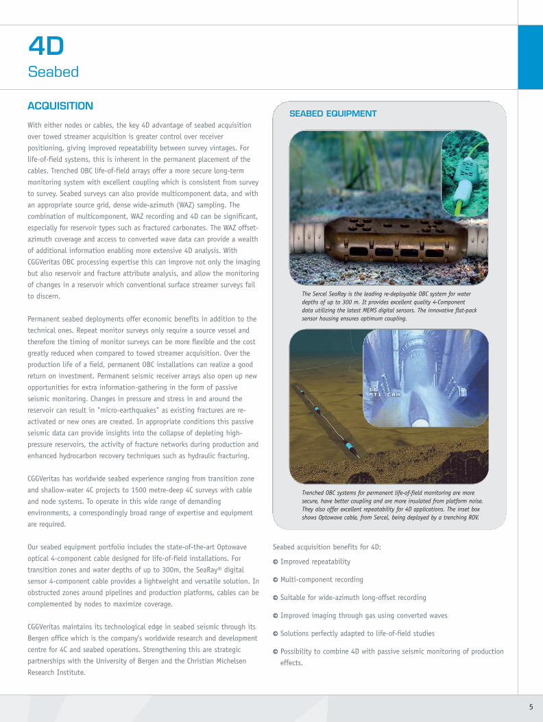
ACQUISITION
With either nodes or cables, the key 4D advantage of seabed acquisition
over towed streamer acquisition is greater control over receiver
positioning, giving improved repeatability between survey vintages. For
life-of-field systems, this is inherent in the permanent placement of the
cables. Trenched OBC life-of-field arrays offer a more secure long-term
monitoring system with excellent coupling which is consistent from survey
to survey. Seabed surveys can also provide multicomponent data, and with
an appropriate source grid, dense wide-azimuth (WAZ) sampling. The
combination of multicomponent, WAZ recording and 4D can be significant,
especially for reservoir types such as fractured carbonates. The WAZ offset-
azimuth coverage and access to converted wave data can provide a wealth
of additional information enabling more extensive 4D analysis. With
CGGVeritas OBC processing expertise this can improve not only the imaging
but also reservoir and fracture attribute analysis, and allow the monitoring
of changes in a reservoir which conventional surface streamer surveys fail
to discern.
Permanent seabed deployments offer economic benefits in addition to the
technical ones. Repeat monitor surveys only require a source vessel and
therefore the timing of monitor surveys can be more flexible and the cost
greatly reduced when compared to towed streamer acquisition. Over the
production life of a field, permanent OBC installations can realize a good
return on investment. Permanent seismic receiver arrays also open up new
opportunities for extra information-gathering in the form of passive
seismic monitoring. Changes in pressure and stress in and around the
reservoir can result in "micro-earthquakes" as existing fractures are re-
activated or new ones are created. In appropriate conditions this passive
seismic data can provide insights into the collapse of depleting high-
pressure reservoirs, the activity of fracture networks during production and
enhanced hydrocarbon recovery techniques such as hydraulic fracturing.
CGGVeritas has worldwide seabed experience ranging from transition zone
and shallow-water 4C projects to 1500 metre-deep 4C surveys with cable
and node systems. To operate in this wide range of demanding
environments, a correspondingly broad range of expertise and equipment
are required.
Our seabed equipment portfolio includes the state-of-the-art Optowave
optical 4-component cable designed for life-of-field installations. For
transition zones and water depths of up to 300m, the SeaRay® digital
sensor 4-component cable provides a lightweight and versatile solution. In
obstructed zones around pipelines and production platforms, cables can be
complemented by nodes to maximize coverage.
CGGVeritas maintains its technological edge in seabed seismic through its
Bergen office which is the company’s worldwide research and development
centre for 4C and seabed operations. Strengthening this are strategic
partnerships with the University of Bergen and the Christian Michelsen
Research Institute.
Seabed acquisition benefits for 4D:
> Improved repeatability
> Multi-component recording
> Suitable for wide-azimuth long-offset recording
> Improved imaging through gas using converted waves
> Solutions perfectly adapted to life-of-field studies
> Possibility to combine 4D with passive seismic monitoring of production
effects.
5
4DSeabed
SEABED EQUIPMENT
Trenched OBC systems for permanent life-of-field monitoring are moresecure, have better coupling and are more insulated from platform noise.They also offer excellent repeatability for 4D applications. The inset boxshows Optowave cable, from Sercel, being deployed by a trenching ROV.
The Sercel SeaRay is the leading re-deployable OBC system for waterdepths of up to 300 m. It provides excellent quality 4-Componentdata utilizing the latest MEMS digital sensors. The innovative flat-packsensor housing ensures optimum coupling.
09B-SV-02-V1_4D_Brochure.qxd:09B-SV-2-V1_4D_Brochure 13/05/09 16:55 Page 5

ACQUISITION
Marine surveys are recorded under dynamic conditions, with every part of
the system being in constant motion. In 4D, these variations from one
vintage to another become important, as differences due to acquisition
may hide the 4D differences in seismic response over time due to changes
in the reservoir. Therefore, at CGGVeritas great care is taken during survey
design and planning to ensure the monitor surveys are shot in as similar a
manner to the baseline survey as possible.
SURVEY PLANNING
The ideal 4D monitor survey is an exact replica of the acquisition of the
baseline survey. This involves repeating source and receiver positions and
matching environmental conditions such as tide state and currents.
For example, in many areas good correlation is observed between streamer
feathering and tidal conditions. So shooting the same line in the same
direction at the same tide state is planned wherever possible. This also
helps to replicate the height of the water-column and therefore the
periodicity of water bottom multiples. Variations in water temperature and
salinity may be seasonal so planning to shoot at the same time of year
may also be desirable.
When the baseline survey suffers from navigation problems due to steering
problems or obstructions it may be undesirable to replicate the survey. In
this case a new optimized navigation pre-plot is required.
CGGVeritas 4D survey planning accounts for:
> Environmental conditions such as tide, currents, weather, time of year
> Optimization of geometry to cope with obstacles and navigation errors.
CURRENT PREDICTION
The effect of currents on streamer geometry can be anticipated during
survey planning. However, more accurate knowledge of currents during the
survey can be a valuable tool in minimizing infill and maximizing 4D
repeatability. CGGVeritas uses sophisticated current models which include
meteorological data and satellite observations to accurately predict
currents, and therefore streamer feathering, several days in advance. This is
augmented by onboard Acoustic Doppler Current Profiling (ADCP) to
measure the actual current ahead of the streamers and calibrate the current
prediction model. This information is used to manage the vessel steering
to address the large-scale effects caused by currents.
STREAMER STEERING
Once the gross positioning has been accounted for by careful planning and
ADCP prediction of feathering, further fine-tuning can be achieved by
steering the streamers dynamically.
In order to make use of the finer positioning accuracy achievable with
steerable birds, it is necessary also to employ fully-braced acoustic
positioning arrays. These provide a more precise knowledge of the streamer
position so that steering devices can maintain the desired streamer
geometry more accurately.
The Sercel Nautilus system combines streamer steering and acoustic
positioning functions into a single device.
4DMarine
6
Quality control of source repeatability during a 4D survey.
Nautilus providesautomatedstreamer steering.Within 14minutes ofactivating thesteering, thespread has beenfully regularized.
WithoutSteering
WithNautilusSteering
Sercel Nautilus® integrated acoustic positioning and streamer control system.
09B-SV-02-V1_4D_Brochure.qxd:09B-SV-2-V1_4D_Brochure 13/05/09 16:55 Page 6
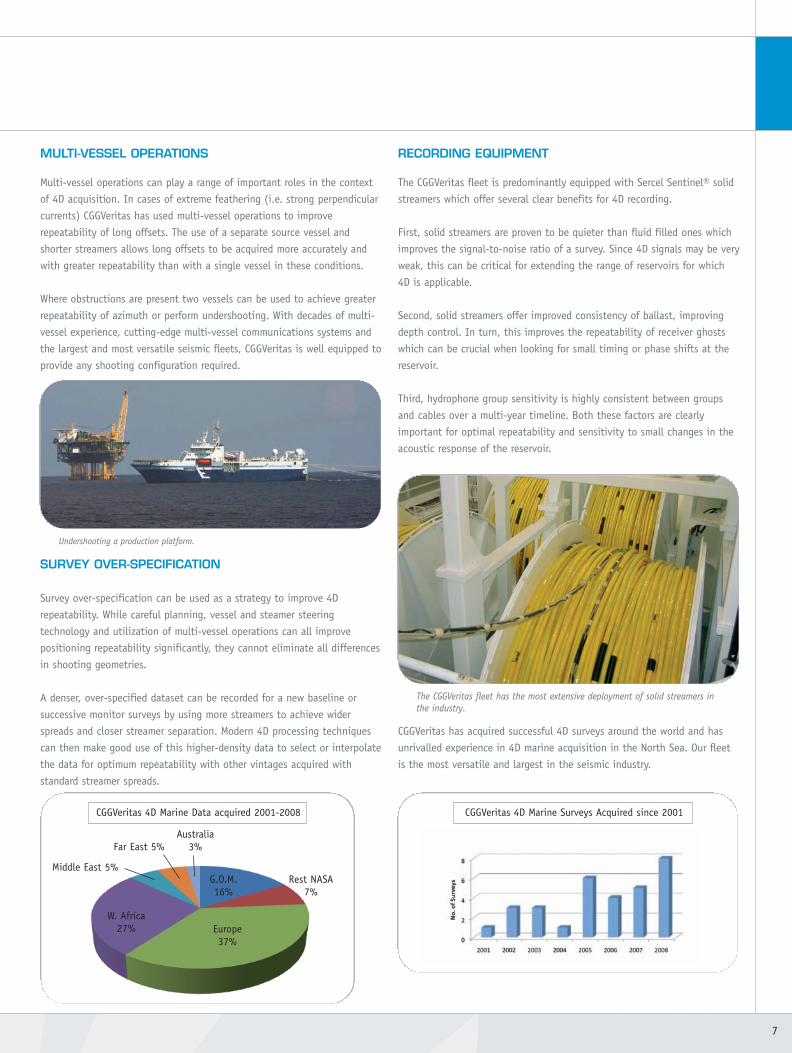
MULTI-VESSEL OPERATIONS
Multi-vessel operations can play a range of important roles in the context
of 4D acquisition. In cases of extreme feathering (i.e. strong perpendicular
currents) CGGVeritas has used multi-vessel operations to improve
repeatability of long offsets. The use of a separate source vessel and
shorter streamers allows long offsets to be acquired more accurately and
with greater repeatability than with a single vessel in these conditions.
Where obstructions are present two vessels can be used to achieve greater
repeatability of azimuth or perform undershooting. With decades of multi-
vessel experience, cutting-edge multi-vessel communications systems and
the largest and most versatile seismic fleets, CGGVeritas is well equipped to
provide any shooting configuration required.
SURVEY OVER-SPECIFICATION
Survey over-specification can be used as a strategy to improve 4D
repeatability. While careful planning, vessel and steamer steering
technology and utilization of multi-vessel operations can all improve
positioning repeatability significantly, they cannot eliminate all differences
in shooting geometries.
A denser, over-specified dataset can be recorded for a new baseline or
successive monitor surveys by using more streamers to achieve wider
spreads and closer streamer separation. Modern 4D processing techniques
can then make good use of this higher-density data to select or interpolate
the data for optimum repeatability with other vintages acquired with
standard streamer spreads.
RECORDING EQUIPMENT
The CGGVeritas fleet is predominantly equipped with Sercel Sentinel® solid
streamers which offer several clear benefits for 4D recording.
First, solid streamers are proven to be quieter than fluid filled ones which
improves the signal-to-noise ratio of a survey. Since 4D signals may be very
weak, this can be critical for extending the range of reservoirs for which
4D is applicable.
Second, solid streamers offer improved consistency of ballast, improving
depth control. In turn, this improves the repeatability of receiver ghosts
which can be crucial when looking for small timing or phase shifts at the
reservoir.
Third, hydrophone group sensitivity is highly consistent between groups
and cables over a multi-year timeline. Both these factors are clearly
important for optimal repeatability and sensitivity to small changes in the
acoustic response of the reservoir.
CGGVeritas has acquired successful 4D surveys around the world and has
unrivalled experience in 4D marine acquisition in the North Sea. Our fleet
is the most versatile and largest in the seismic industry.
7
The CGGVeritas fleet has the most extensive deployment of solid streamers inthe industry.
CGGVeritas 4D Marine Data acquired 2001-2008 CGGVeritas 4D Marine Surveys Acquired since 2001
Far East 5%Australia
3%
G.O.M.16%
Rest NASA7%
Europe37%
Middle East 5%
W. Africa27%
Nautilus providesautomatedstreamer steering.Within 14minutes ofactivating thesteering, thespread has beenfully regularized.
Undershooting a production platform.
09B-SV-02-V1_4D_Brochure.qxd:09B-SV-2-V1_4D_Brochure 13/05/09 16:56 Page 7

ACQUISITION
In the case of onshore 4D projects the challenges are somewhat different
from marine 4D acquisition. Although repeatability of source and receiver
locations are generally easier to achieve, the 4D variations caused by
changes in near-surface conditions can be orders of magnitude higher.
Careful planning of the initial baseline survey and a consideration of the
expected changes in the response of the near-surface, as well as the
reservoir, are essential to assure that a usable 4D signature is obtained.
Positioning accuracy, and therefore repeatability, has been revolutionized
by the use of “stakeless” GPS positioning systems. Not only are actual
coordinates recorded more accurately, but integrated navigation systems
ensure that receivers and sources are deployed as close to the pre-defined
targets as possible. Stakeless surveying can eliminate many of the
navigation errors which previously affected 4D repeatibility.
The move to high-density and wide-azimuth land acquisition geometries,
particularly with single-source single-receiver configurations, has great
benefits for land 4D. The use of point source and point receivers results in
more consistent and repeatable responses and removes unwanted array
effects which create azimuthally-varying attenuation. 4D processing in
particular benefits from:
> More accurate, higher-resolution statics solutions
> More accurate imaging with higher-resolution velocities
> More effective noise attenuation utilizing 3D algorithms.
SEISMOVIE
SeisMovie is a permanent seismic monitoring solution developed by
CGGVeritas in conjunction with Gaz de France and IFP. The system was
initially designed for the monitoring of underground gas storage whereby
gas is stored in natural subsurface reservoirs. These storage reservoirs
require frequent and accurate observation to monitor gas saturation and
the extent of the gas bubble during usage.
To fulfil these criteria a completely autonomous system was designed
utilizing buried receiver arrays and a novel piezoelectric vibrator source.
Using a permanent buried installation ensures excellent 4D repeatability
and coupling. By placing the source and sensors below the weathering
layer, SeisMovie eliminates near-surface variations to further improve 4D
repeatability over extended periods.
The piezoelectric source is well suited for permanent installation and has a
very stable source signature which further contributes to the repeatability
of the system. Several sources can be distributed throughout the survey
area, and using a patented discrete frequency sweep, can operate
simultaneously adding significantly to the data density.
The system is flexible and versatile and can use a variety of receiver
configurations to achieve different monitoring objectives. For areal
coverage over a large target, long arrays or grids of buried geophones can
be installed, whereas to increase vertical sensitivity of the system, arrays
of sensors (2, 3 or 4 component) can be permanently installed in vertical
boreholes to provide VSP-style datasets.
SeisMovie systems routinely achieve a vertical sensitivity of 0.1
milliseconds with a usable signal bandwidth up to 250Hz. This capability
allows monitoring of subtle and rapid reservoir variations which are
impossible for conventional surface-borne 4D surveys.
Benefits:
> Captures subtle reservoir variations
> Enables monitoring of previously unsuitable reservoirs
> Provides continuous monitoring for real-time production decisions
> Highly reliable remote autonomous operation
> Minimal environmental impact
> Minimal surface interference at busy production sites.
4DLand
8
Integrated navigation system display showing exclusion zones for the survey.These in-vehicle systems guide vibrator sources accurately to their shotpoints.
A schematic SeisMovie installation for a SAGDheavy oil production operation. Buried
piezo-electric sources are shown inyellow along with a network of
buried receiver arrays. Theautonomous system works 24hrs a day, recording and pre-processing data on sitebefore transmitting it back tothe office for analysis.
09B-SV-02-V1_4D_Brochure.qxd:09B-SV-2-V1_4D_Brochure 13/05/09 16:56 Page 8

HEAVY OIL SAGD MONITORING
Typical oil and gas reservoirs have a lifespan of many years and evolve
slowly over their productive life. Repeat surveys every few years are
therefore appropriate for 4D seismic monitoring. Heavy oil reservoirs
produced using steam-assisted gravity drainage (SAGD) have a much
shorter life-cycle. The state of the reservoir can vary significantly over the
course of weeks and months so it is important to monitor production
effects on a much more frequent basis.
To have a seismic crew on call to perform weekly or even monthly surveys
is economically unrealistic. Among the other problems faced in this
scenario is the extensive surface infrastructure around the fields which will
interfere with acquisition, both in terms of surface coverage and high
levels of background noise.
The example shown was conducted in 2005 over a heavy oil field. A single
buried source and a grid of 400 receivers monitored a shallow,
unconsolidated tar sand reservoir for a one-month period of steam
injection. Recording was near-continuous, with 240 records acquired per
hour, pre-processed automatically on-site and transferred via an internet
link for analysis. Detailed QC of the continuous seismic record ensures that
anomalies are easily and quickly identified. Over a 30-day period the field
data showed the progressive effects of steam injection, with transit time
variation maps (below) revealing the irregular nature of the steam
propagation into the reservoir and the corresponding effectiveness of the
individual injection wells (denoted by the lines across the maps). Despite
high levels of noise generated by the adjacent steam plant, the results
show good signal content and bandwidth with good correlation to well
data.
9
The image shows a set of lines through a shot gather summation for 24 hrs ofrecorded data after basic pre-processing and NMO correction.The lower power source sweeps several time an hour so that in a 24hr periodenough energy is emitted to produce a coherent stack. The frequency content atthe base of the reservoir is up to 240Hz. A cone of noise centred on the sourcelocation is visible (highlighted in red) at this preliminary processing stage.
Map view of cumulative transit-time variation through a heavy oil reservoir over a 30-day period. The sensitivity of the SeisMovie installation meant that time-shifts of 0.1ms could be reliably detected and production could be monitored in real time. The red lines represent steam injection wells and the white discrepresents the area affected by the noise cone from the source (see above).
0.25
-0.25Day 10 Day 17 Day 28
09B-SV-02-V1_4D_Brochure.qxd:09B-SV-2-V1_4D_Brochure 13/05/09 16:57 Page 9

4DProcessing & Imaging
OVERVIEW
CGGVeritas has been at the forefront of 4D processing since its inception.
Our expertise in this field is recognized throughout the industry with the
result that we not only offer 4D processing and imaging in our open
centers, but also operate specialist 4D dedicated centers for our clients.
Processing time-lapse datasets requires great care and attention to detail
which is why our experience really makes a difference.
The aim of 4D processing is to attenuate the 4D noise caused by changes
in acquisition parameters or environmental conditions, and to emphasize
the 4D signature of the reservoir caused by changes in fluid, pressure and
stress. Over the years, our 4D research group has developed the tools and
techniques to achieve this. Greater expertise and advances in conventional
3D processing have also benefited 4D processing. For example, progress in
statics, multiple attenuation and depth imaging all contribute to improving
the quality of 4D processing results.
4D PROCESSING STRATEGY
CGGVeritas has been pioneering 4D processing since 1987, when it
introduced pre-stack parallel processing. This involves the processing or re-
processing of all the 4D vintages in unison using coupled or simultaneous
4D processes with parameters and models optimized for all of the vintages.
At every stage in the processing sequence 4D QC attributes such as NRMS
are monitored to confirm that the vintages are increasingly more
compatible. An important aspect of this strategy is the application of
relevant pre-stack deterministic corrections instead of relying solely on
post-stack matching. This rigorous approach ensures that the 4D noise will
be more accurately targeted and the 4D reservoir signature will be
preserved.
STATICS
Static differences between vintages occur in both land and marine 4D
surveys. They are caused by changes in the near-surface, weathering layer,
water column or water surface conditions. CGGVeritas has developed a
range of strategies and algorithms for both land and marine 4D surveys.
For marine surveys, application of deterministic GPS-based tidal and wave-
height corrections and statistical 4D corrections for water column statics
greatly reduce the acquisition footprint.
REGULARIZATION
The regularization of 4D datasets uses bin centering and interpolation of
missing data to create either regularly sampled datasets on a common grid,
or map monitor survey data to a base survey grid. CGGVeritas has
developed REVIVE, a Fourier regularization technique using up to 5
dimensions (x, y, offset, azimuth and time) which provides dramatic
increases in the accuracy of the interpolation and benefits 4D processing.
Regularization ensures:
> Co-location of traces between vintages
> Improved matching of azimuths between vintages
> Infill of gaps and better offset distribution for:
10
4D QC
A range of 4D attributes can be used to monitor the progress of 4D
processing. The most commonly used are:
NRMS Normalized RMS amplitude is sensitive to static shifts, phase or
amplitude differences. Low NRMS indicates high repeatability.
Predictability is sensitive to noise and changes in reflectivity, higher
values implying greater repeatability.
In addition complex trace analysis can be used to derive the
instantaneous phase and amplitude components of the 4D differences,
which are useful tools for QC and interpretation.
NRMS repeatability attribute map of 4D difference after 4D binning.The red stripes (indicating low repeatability due to differences in the acquisition)have been minimised. 4D binning uses a set of geometry and 4D QC criteria toselect the most compatible traces. It has recently been extended to performmulti-vintage binning where the global repeatability for all vintages is maximized.
NRMS repeatibility attribute map of 4D difference before 4D binning.
09B-SV-02-V1_4D_Brochure.qxd:09B-SV-2-V1_4D_Brochure 13/05/09 16:58 Page 10
- Improved gather processing such as Radon de-multiple
- Reduced migration artefacts
> Data is optimally conditioned for 4D binning.
4D BINNING
4D binning is an essential step in time-lapse processing which selects the
most compatible data for 4D processing. Traces are selected from all of the
vintages making up the 4D dataset which are best matched in terms of
source, receiver and midpoint position, offset and azimuth. The binning
criteria can be extended to include statistical measurements of 4D data
quality such as cross-correlation, predictability and NRMS.
Simultaneous binning of all vintages ensures:
> The most compatible traces from each acquisition vintage are selected
> Acquisition differences between vintages are minimized
> Systematic errors between vintages are avoided.
DE-STRIPING
Systematic amplitude variations related to the acquisition geometry create
a pattern or acquisition footprint. The footprint within each vintage is
emphasized in 4D difference between them, as shown by the NRMS
attribute map on the facing page.
De-striping techniques are routinely used in conventional 3D processing.
For 4D processing, CGGVeritas utilizes a 4D de-striping technique where data
from all vintages is analyzed for systematic variations with respect to
acquisition attributes, such as sail line, and scalars are calculated to
compensate for them. Geostatistical techniques are also effective at
removing these systematic acquisition-related variations.
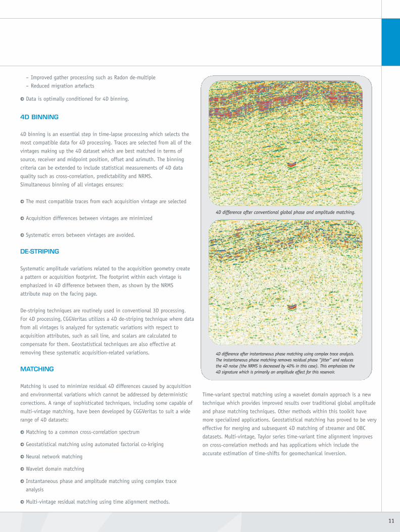
MATCHING
Matching is used to minimize residual 4D differences caused by acquisition
and environmental variations which cannot be addressed by deterministic
corrections. A range of sophisticated techniques, including some capable of
multi-vintage matching, have been developed by CGGVeritas to suit a wide
range of 4D datasets:
> Matching to a common cross-correlation spectrum
> Geostatistical matching using automated factorial co-kriging
> Neural network matching
> Wavelet domain matching
> Instantaneous phase and amplitude matching using complex trace
analysis
> Multi-vintage residual matching using time alignment methods.
Time-variant spectral matching using a wavelet domain approach is a new
technique which provides improved results over traditional global amplitude
and phase matching techniques. Other methods within this toolkit have
more specialized applications. Geostatistical matching has proved to be very
effective for merging and subsequent 4D matching of streamer and OBC
datasets. Multi-vintage, Taylor series time-variant time alignment improves
on cross-correlation methods and has applications which include the
accurate estimation of time-shifts for geomechanical inversion.
11
4D difference after instantaneous phase matching using complex trace analysis.The instantaneous phase matching removes residual phase “jitter” and reducesthe 4D noise (the NRMS is decreased by 40% in this case). This emphasizes the4D signature which is primarily an amplitude effect for this reservoir.
4D difference after conventional global phase and amplitude matching.
09B-SV-02-V1_4D_Brochure.qxd:09B-SV-2-V1_4D_Brochure 13/05/09 16:59 Page 11
4D IMAGING
CGGVeritas is a world leader in seismic imaging and has pioneered the use
of depth imaging, in particular anisotropic pre-stack depth migration (TTI
PSDM), in 4D processing. Depth imaging has a number of clear advantages
which makes it more suited for 4D than time imaging:
> Improved spatial positioning of structure
> Improved focusing for sharper 4D differences
> Comprehensive set of techniques to enable more accurate velocity model
building.
4D LAND & OBC
Land and OBC 4D surveys have additional processing needs and
advantages. These can include multicomponent processing and merging of
streamer and OBC datasets in obstructed fields. With many of these
surveys providing wide-azimuth datasets CGGVeritas can also bring to bear
its unparalleled experience of wide-azimuth processing, including:
> Multi-azimuth, multi-vintage binning
> Tau-px-py noise attenuation and deconvolution
> 3D high-resolution Radon de-multiple
> REVIVE 5D wide-azimuth interpolation
> Elastic modeling and subtraction of the direct arrival
> Azimuthal AVO.
4DProcessing & Imaging
12
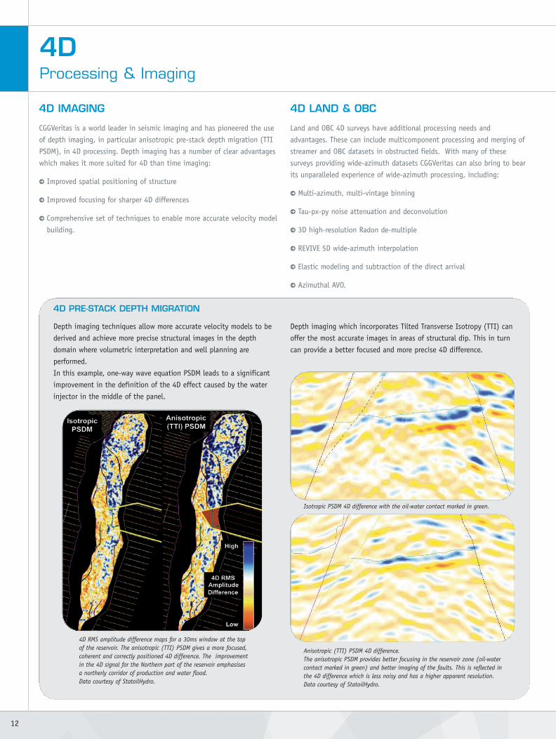
4D RMS amplitude difference maps for a 30ms window at the topof the reservoir. The anisotropic (TTI) PSDM gives a more focused,coherent and correctly positioned 4D difference. The improvementin the 4D signal for the Northern part of the reservoir emphasisesa northerly corridor of production and water flood.Data courtesy of StatoilHydro.
Anisotropic (TTI) PSDM 4D difference.The anisotropic PSDM provides better focusing in the reservoir zone (oil-watercontact marked in green) and better imaging of the faults. This is reflected inthe 4D difference which is less noisy and has a higher apparent resolution.Data courtesy of StatoilHydro.
4D PRE-STACK DEPTH MIGRATION
Depth imaging techniques allow more accurate velocity models to be
derived and achieve more precise structural images in the depth
domain where volumetric interpretation and well planning are
performed.
In this example, one-way wave equation PSDM leads to a significant
improvement in the definition of the 4D effect caused by the water
injector in the middle of the panel.
Depth imaging which incorporates Tilted Transverse Isotropy (TTI) can
offer the most accurate images in areas of structural dip. This in turn
can provide a better focused and more precise 4D difference.
Isotropic PSDM 4D difference with the oil-water contact marked in green.
09B-SV-02-V1_4D_Brochure.qxd:09B-SV-2-V1_4D_Brochure 13/05/09 16:59 Page 12
4D INTERPRETATION
The results of a 4D survey are used rather differently than those of a 2D or 3D
survey. The interpretation is focused on the production & development stages
of a field and is concerned with changes in the reservoir, usually the fluid
content and movement within the structures. By tracking these it is possible
to monitor the flow of hydrocarbons within the reservoirs, gain greater
understanding of the reservoir behavior and optimize its development.
HAMPSON-RUSSELL PRO4D
In addition to providing world-class processing services, CGGVeritas,
through its subsidiary Hampson-Russell, also provides a powerful 4D
characterization package, PRO4D.
Time-lapse projects are becoming increasingly more complex, with multiple
monitor surveys and multiple angle volumes per survey. PRO4D’s advanced
management system helps organize the data so that 4D or multi-attribute
volumes can be viewed, processed or interpreted as easily as if they were a
single 3D volume.
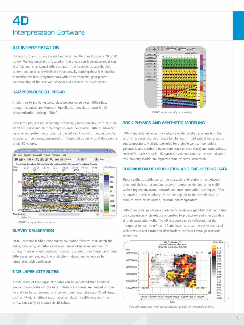
SURVEY CALIBRATION
PRO4D contains leading-edge survey calibration features that match the
phase, frequency, amplitude and event times of baseline and monitor
surveys in areas where production has not occurred. Once these background
differences are removed, the production-induced anomalies can be
interpreted with confidence.
TIME-LAPSE ATTRIBUTES
A wide range of time-lapse attributes can be generated that highlight
production anomalies in the data. Difference volumes are created on-the-
fly and can be co-rendered with conventional data. Standard 4D attributes,
such as NRMS, amplitude ratio, cross-correlation coefficients and time
shifts, can easily be created as 3D cubes.
ROCK PHYSICS AND SYNTHETIC MODELING
PRO4D supports advanced rock physics modeling that assesses how the
seismic response will be affected by changes in fluid saturation, pressure
and temperature. Multiple scenarios for a single well can be rapidly
generated, and synthetic traces (pre-stack or post stack) are automatically
created for each scenario. 3D synthetic volumes can also be created when
rock property models are imported from reservoir simulation.
COMPARISON OF PRODUCTION AND ENGINEERING DATA
These synthetic attributes can be analyzed, and relationships between
them and their corresponding reservoir properties derived using multi-
variate regression, neural network and cross-correlation techniques. After
calibration, these relationships can be applied to the seismic data to
produce maps of saturation, pressure and temperature.
PRO4D contains an advanced volumetric analysis capability that facilitates
the comparison of time-lapse anomalies to production and injection data
at their associated wells. The 4D response can be validated and the
interpretation can be refined. 4D attribute maps can be easily compared
with pressure and saturation distributions estimated through reservoir
simulation.
13
4DInterpretation Software
PRO4D survey calibration window.
PRO4D survey rock physics modeling.
Time-shift delay map which can be used as the basis for volumetric analysis.
09B-SV-02-V1_4D_Brochure.qxd:09B-SV-2-V1_4D_Brochure 13/05/09 17:00 Page 13

Inversion with standard constraints
Oil sand probability
Oil sand probability
1992
2003
0%100%
0%100%
Inversion with asymmetrical 4D constraints
1992
2003
PRE-CONDITIONING
The quality and reliability of the results obtained from seismic inversion for
elastic or reservoir properties can be improved by pre-conditioning the pre-
stack data. This generally includes additional noise attenuation, residual
corrections to flatten events in the gathers and stabilization of the seismic
wavelet (between vintages and offsets). These processes are designed to
reduce the noise and jitter affecting pre-stack events while preserving the
AVO information they contain.
CGGVeritas has developed a pre-conditioning technique specifically to
enhance the AVO information within pre-stack gathers. STAVO is a co-
filtering technique applied to intercepts and gradients after AVO fitting. It
is based on the principle that noise-free reflectors yield a constant relation
between intercept and gradient when convolved with a wavelet.
Changes in attenuation between 4D surveys can be significant sources of
amplitude and phase differences, particularly where gas injection is being
performed. This can be dealt with by a differential Q (4DQ) controlled
calibration. Linear regression is performed using spectral ratios between
two windows simultaneously for the baseline and monitor survey to
produce the 4DQ attribute. This describes the spectral variation relating to
residual absorption between the 4D vintages and is used for the
calibration.
GLOBAL 4D ELASTIC INVERSION
Tracking the movements of fluids due to production gives valuable
information about the depletion of a field, and can indicate areas of
bypassed oil or gas. Changes in fluid saturation and reservoir pressure can
be estimated by applying 4D inversion followed by rock physics inversion.
Traditionally each vintage is inverted independently, but experience shows
that coupling the inversion of the baseline and monitor surveys is
important to reduce the non-uniqueness of the inversion process and
obtain quantitative estimates of changes in impedance.
The CGGVeritas global 4D inversion scheme addresses this by inverting all
data vintages simultaneously. The time evolution of the resulting elastic
attributes are constrained by simple rock physics rules restricting the range
of variations between consecutive surveys.
Coupling the global inversion with 4D Bayesian lithology classification
allows reservoir properties to be derived from the elastic attributes. This
facilitates interpretation and quantifies the uncertainties in the inversion
results, providing a valuable input for reservoir management decisions.
Benefits:
> Optimum global result for all vintages
> Meaningful results constrained by 4D petrophysical models
> Quantitative estimates of reservoir properties.
4DInterpretation & Reservoir
14
CONSTRAINING 4D INVERSION
4D seismic reservoir monitoring has been used on the mature Brage Field in
the Norwegian North Sea to identify unswept zones in the reservoir. Using
data from 1992 and 2003 surveys, global 4D inversion was carried out
initially without any specific 4D constraints (i.e. elastic attributes could
increase or decrease freely within standard limits). The result fits the
seismic data but does not take advantage of the available a priori 4D
knowledge of the reservoir, and is therefore not necessarily consistent with
the production history of the field.
By incorporating available knowledge about the reservoir such as the
production regime and its expected behavior, the intrinsic non-uniqueness
of seismic inversion can be controlled. In this case the reservoir is
undergoing enhanced oil recovery by water injection, so an asymmetrical
4D constraint is used which only allows increases in P-Impedance and
Vp/Vs (representing the displacement of oil by water) and this is limited to
within the reservoir interval.
The results of the global inversion with rock physics constraints provide a
result which fits the production history of the field and the available well
data more accurately. For the 2003 inversion results, the remaining oil is
mapped with a much higher probability which means bypassed zones of the
reservoir can be identified with a much higher certainty.
09B-SV-02-V1_4D_Brochure.qxd:09B-SV-2-V1_4D_Brochure 13/05/09 17:00 Page 14

GEOMECHANICS
In addition to the movement of fluids, changes in pressure and stress in and
around reservoirs is a natural consequence of production. For high-pressure
reservoirs, pressure depletion during production is associated with compaction
within the reservoir causing stretching or extensional stresses in the overbur-
den and underlying formation. This causes variation in velocities and formation
thickness which can be observed as 4D time shifts between successive vin-
tages. Over the Chalk reservoirs of the North Sea these stress changes can even
result in subsidence at the seabed (the Ekofisk field, for example).
Geomechanical modeling can be used to explain and predict these 4D time
shifts, using relationships which relate velocity changes to stress-induced frac-
tional thickness variations for a range of lithologies. These relationships are
used in the inversion of the observed pre-stack, offset-dependent time shifts
for geomechanical properties.
In addition to the obvious compressional effects within the reservoir, exten-
sional stress is experienced above and at the edges of producing reservoirs.
This extensional stress above the reservoir generally makes the largest contri-
bution to the observed time shift.
Compaction of the reservoir generates significant changes in radial stress
around its edges which create a 4D anisotropy signature. CGGVeritas has
extended geomechanical inversion to include the estimation of 4D anisotropy
using offset-dependent 4D time shifts. This provides a unique solution for the
delineation of depleted and compacted zones in the reservoir.
Benefits:
> Improved understanding of 4D response of compacting reservoirs
> Production monitoring in fields with small 4D signatures
> Indication of potential wellbore instability in HPHT fields
> Complements 4D elastic inversion techniques to improve discrimination
of production effects within the reservoir.
15
MONITORING COMPACTING RESERVOIRS
Some fields are characterized by high-pressure regimes which exhibit
significant pressure depletion during production. In the case of the
Elgin field (North Sea Central Graben) a 500bar decrease in pressure
has been observed over the life of the field.
-6ms
+6ms
extension
compression
Elgin Field
4D Time shift
4D Stress
Elgin Field
Strong compressional stress is observed within the reservoir due to production-related compaction (middle). Above and at the edges of the reservoir,extensional stress is observed as the surrounding rocks compensate for thecompaction of the reservoir. This extensional compensation in the overburdencreates the large observed time shifts above the reservoir (top).
4D anisotropy variations can also be observed in the offset dependency of thesetime shifts (bottom). These can be related to changes in the radial stress fieldand can be used to delineate the extent of the producing reservoir (dashed line). 4D changes in vertical stress derived from inversion of 4D time shifts in
the region of the Elgin field complex.
decrease
increase
4D Anisotropy
Producing well
09B-SV-02-V1_4D_Brochure.qxd:09B-SV-2-V1_4D_Brochure 13/05/09 17:01 Page 15
Worldwide HeadquartersTour Maine-Montparnasse
33, Avenue du Maine B.P. 191
75755 Paris Cedex 15 FRANCE
Tel: +33 1 64 47 45 00
Fax: +33 1 64 47 34 31
1, rue Léon Migaux
91341 Massy Cedex FRANCE
Tel: +33 1 64 47 30 00
Fax: +33 1 64 47 39 70
10300 Town Park Drive
Houston, TX 77072 U.S.A.
Tel: +1 832 351 8300
Fax: +1 832 351 8701
Regional OfficesCalgary +1 403 205 6000
Bergen +47 56 11 31 00
London +44 1293 683000
Singapore +65 6723 5500
09B-SV-2-V1cggveritas.com
SeisMovie is a trademark of CGGVeritas.
This document is printed on paper that comes from sustainably managed forests.Chain of custody number: CTBA/06-00743 Printed in France by Caractere
09B-SV-02-V1_4D_Brochure.qxd:09B-SV-2-V1_4D_Brochure 13/05/09 17:01 Page 16


![10 09B AidesFinancieresBBCEffinergie[1]](https://static.fdocuments.net/doc/165x107/55cf96e7550346d0338e9145/10-09b-aidesfinancieresbbceffinergie1.jpg)


