06.10 Hazardous Materials - Port Authority of New York … locations. • Fuel Oil and Gasoline...
36
6.10-1 Chapter 6.10: Hazardous Materials A. INTRODUCTION This chapter examines the potential effects of the proposed alternatives related to contaminated materials, including contaminated soil and groundwater. It assesses the soil and groundwater conditions for those study areas that would be subject to construction activities under the proposed alternatives (i.e., tunnel alignments, rail lines, and facilities). For each site that would be affected by the proposed project, the analysis begins by considering the location, type, and extent of contaminated materials that may be present in the soil or groundwater due to past or present uses on or adjacent to the site. As described below, this assessment was conducted through a review of historic maps, regulatory records, and site visits. The assessment then considers the proposed project’s potential to encounter any potentially contaminated soil and groundwater. This evaluation focuses on construction activities since the construction work for the project would disturb the soil and, in some locations, the groundwater. Construction activities are considered with respect to soil and groundwater conditions to assess any potential risks to public health, safety, and the environment. The last section of the chapter identifies areas requiring further investigation as part of any future Tier II documentation and describes mitigation measures to be employed to avoid potential impacts related to contaminated materials during the construction of the project alternatives and once the project is completed and operational. B. METHODOLOGY Soil and groundwater beneath a site can become contaminated due to past or present uses on the site or adjacent properties. Most of the sites affected by the project are currently or were historically in railroad use. Normal operations at rail yards—including maintenance and routine operations—can over time lead to contamination from spills. On and along rail lines, common contaminants include volatile and semi-volatile organic compounds, heavy metals, polychlorinated biphenyls (PCBs), pesticides, and herbicides. The study areas around the proposed or expanded rail yards may also have been contaminated by past or current uses of neighboring properties, particularly since many of the affected sites are located in largely industrial and manufacturing areas. In addition, some of the sites are built on fill material, which often contains contaminants such as polycyclic aromatic hydrocarbons (PAHs) and heavy metals. Some of the potential common constituents of concern for the sites and adjacent areas are discussed in greater detail below: • Heavy Metals – These include lead, cadmium, chromium, and mercury. These have been widely used in many industries, including printers, foundries, and metal working facilities and are found in paint, ink, petroleum products, and coal ash and cinders. Lead is also a common component of paint on bridges or other steel structures, and can be found in elevated concentrations in soil near roadways as a result of the historic use of leaded gasoline.
Transcript of 06.10 Hazardous Materials - Port Authority of New York … locations. • Fuel Oil and Gasoline...

6.10-1
Chapter 6.10: Hazardous Materials
A. INTRODUCTION This chapter examines the potential effects of the proposed alternatives related to contaminated materials, including contaminated soil and groundwater. It assesses the soil and groundwater conditions for those study areas that would be subject to construction activities under the proposed alternatives (i.e., tunnel alignments, rail lines, and facilities).
For each site that would be affected by the proposed project, the analysis begins by considering the location, type, and extent of contaminated materials that may be present in the soil or groundwater due to past or present uses on or adjacent to the site. As described below, this assessment was conducted through a review of historic maps, regulatory records, and site visits. The assessment then considers the proposed project’s potential to encounter any potentially contaminated soil and groundwater. This evaluation focuses on construction activities since the construction work for the project would disturb the soil and, in some locations, the groundwater. Construction activities are considered with respect to soil and groundwater conditions to assess any potential risks to public health, safety, and the environment. The last section of the chapter identifies areas requiring further investigation as part of any future Tier II documentation and describes mitigation measures to be employed to avoid potential impacts related to contaminated materials during the construction of the project alternatives and once the project is completed and operational.
B. METHODOLOGY Soil and groundwater beneath a site can become contaminated due to past or present uses on the site or adjacent properties. Most of the sites affected by the project are currently or were historically in railroad use. Normal operations at rail yards—including maintenance and routine operations—can over time lead to contamination from spills. On and along rail lines, common contaminants include volatile and semi-volatile organic compounds, heavy metals, polychlorinated biphenyls (PCBs), pesticides, and herbicides. The study areas around the proposed or expanded rail yards may also have been contaminated by past or current uses of neighboring properties, particularly since many of the affected sites are located in largely industrial and manufacturing areas. In addition, some of the sites are built on fill material, which often contains contaminants such as polycyclic aromatic hydrocarbons (PAHs) and heavy metals. Some of the potential common constituents of concern for the sites and adjacent areas are discussed in greater detail below:
• Heavy Metals – These include lead, cadmium, chromium, and mercury. These have been widely used in many industries, including printers, foundries, and metal working facilities and are found in paint, ink, petroleum products, and coal ash and cinders. Lead is also a common component of paint on bridges or other steel structures, and can be found in elevated concentrations in soil near roadways as a result of the historic use of leaded gasoline.

Cross Harbor Freight Program
6.10-2
• Volatile Organic Compounds (VOCs) – These compounds include aromatic compounds such as benzene, toluene, ethylbenzene, and xylene (BTEX), which are found in gasoline and other fuel products, vehicle repair and metal works, as well as many other industries; and chlorinated compounds such as trichloroethylene (TCE) and tetrachloroethylene (PCE), common ingredients in solvents and cleaners sued in metal degreasing, dry cleaners, and other industrial facilities. Groundwater may become contaminated with VOCs and vapors can be released, especially during excavation activities. In addition, some VOCs can be flammable if the vapors are confined.
• Semivolatile Organic Compounds (SVOCs) – These include PAHs which are common constituents of partially combusted coal or petroleum-derived products; coal-derived products such as creosote applied to protect rail ties; and coal and coal ash used as fill.
• Pesticides and Herbicides – These compounds are commonly used to control rodents and/or insects, and treat vegetation in rail yards and along rail lines, particularly between tracks.
• Polychlorinated Biphenyls – PCBs were commonly used as a dielectric fluid in train-mounted or yard transformers and are therefore of special concern at rail yards and train maintenance locations.
• Fuel Oil and Gasoline Storage Tanks – many of the rail yards, businesses, and industries located once located in the project areas contained aboveground storage tanks (ASTs) or underground storage tanks (USTs) containing petroleum products. Some of these tanks may have been removed while other tanks, although no longer in use, may remain buried in place in the project areas. In some locations, spills and leaks associated with such tanks may have occurred. Soils and groundwater in close proximity to fuel oil and gasoline storage tanks may be contaminated due to ongoing or past leaks or spills. Fuel oil and gasoline form off-site sources may have migrated to the project sites, contaminating oil and groundwater on site.
• Asbestos containing materials (ACM) may be located within buildings or on underground steam pipes, or in uncontrolled dump sites.
For each location where construction activities could disturb potentially contaminated materials, a limited preliminary environmental site assessment was conducted. Each environmental site assessment was assessed by a three-part investigation including (1) historical and current land use review, (2) environmental database and records research, and (3) review of the previous Phase II Environmental Site Investigations and other environmental studies conducted at adjacent sites, as applicable. This process was followed to determine the potential presence of contaminated and hazardous materials on, below, or adjacent to a site.
The review of past and current land use began with research to determine the past uses on or within 1,000 feet of each site. Information disclosed in the 2004 Cross Harbor Freight Movement Project Draft Environmental Impact Statement (“2004 DEIS”) was updated. For sites not previously assessed, the research involved examining historic maps (Sanborn real estate atlases and fire insurance maps dating back to late 1800s or early 1900s) for such uses as gasoline stations, electric substations, gasworks, chemical works, and other uses that could have resulted in contamination of underlying soil and groundwater.
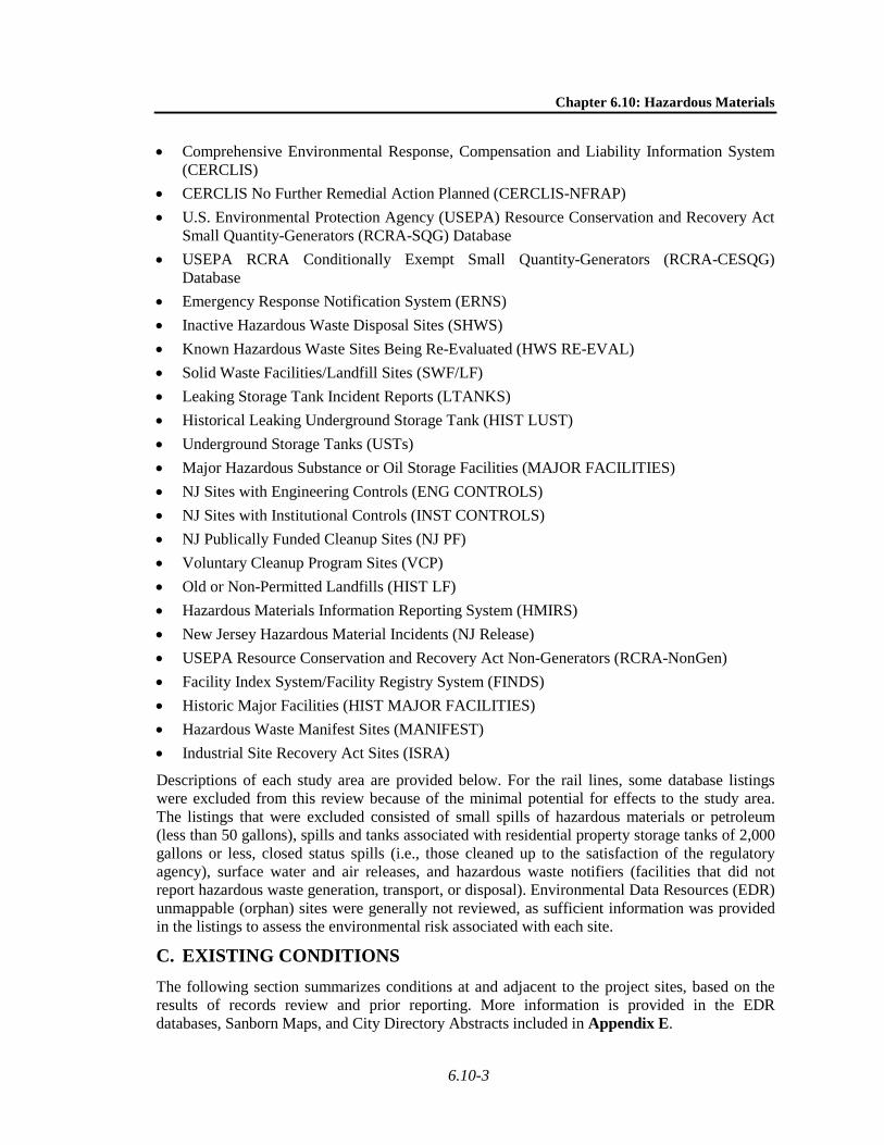
Federal and state database and regulatory records and databases were reviewed—including listings of hazardous materials spills, petroleum storage facilities, and state and federally listed hazardous waste sites—to determine the regulatory status of each site, adjacent properties, and properties within 1,000 feet of a study area. The following federal and state databases were reviewed:
Chapter 6.10: Hazardous Materials
6.10-3
• Comprehensive Environmental Response, Compensation and Liability Information System (CERCLIS)
• CERCLIS No Further Remedial Action Planned (CERCLIS-NFRAP) • U.S. Environmental Protection Agency (USEPA) Resource Conservation and Recovery Act
Small Quantity-Generators (RCRA-SQG) Database • USEPA RCRA Conditionally Exempt Small Quantity-Generators (RCRA-CESQG)
Database • Emergency Response Notification System (ERNS) • Inactive Hazardous Waste Disposal Sites (SHWS) • Known Hazardous Waste Sites Being Re-Evaluated (HWS RE-EVAL) • Solid Waste Facilities/Landfill Sites (SWF/LF) • Leaking Storage Tank Incident Reports (LTANKS) • Historical Leaking Underground Storage Tank (HIST LUST) • Underground Storage Tanks (USTs) • Major Hazardous Substance or Oil Storage Facilities (MAJOR FACILITIES) • NJ Sites with Engineering Controls (ENG CONTROLS) • NJ Sites with Institutional Controls (INST CONTROLS) • NJ Publically Funded Cleanup Sites (NJ PF) • Voluntary Cleanup Program Sites (VCP) • Old or Non-Permitted Landfills (HIST LF) • Hazardous Materials Information Reporting System (HMIRS) • New Jersey Hazardous Material Incidents (NJ Release) • USEPA Resource Conservation and Recovery Act Non-Generators (RCRA-NonGen) • Facility Index System/Facility Registry System (FINDS) • Historic Major Facilities (HIST MAJOR FACILITIES) • Hazardous Waste Manifest Sites (MANIFEST) • Industrial Site Recovery Act Sites (ISRA)
Descriptions of each study area are provided below. For the rail lines, some database listings were excluded from this review because of the minimal potential for effects to the study area. The listings that were excluded consisted of small spills of hazardous materials or petroleum (less than 50 gallons), spills and tanks associated with residential property storage tanks of 2,000 gallons or less, closed status spills (i.e., those cleaned up to the satisfaction of the regulatory agency), surface water and air releases, and hazardous waste notifiers (facilities that did not report hazardous waste generation, transport, or disposal). Environmental Data Resources (EDR) unmappable (orphan) sites were generally not reviewed, as sufficient information was provided in the listings to assess the environmental risk associated with each site.
C. EXISTING CONDITIONS The following section summarizes conditions at and adjacent to the project sites, based on the results of records review and prior reporting. More information is provided in the EDR databases, Sanborn Maps, and City Directory Abstracts included in Appendix E.

Cross Harbor Freight Program
6.10-4
WEST-OF-HUDSON AREA
OAK ISLAND YARD
Site Description and History The Oak Island study area is an approximate 90-acre and irregular-shaped property that generally stretches east to west and is located north of Port Newark-Elizabeth Marine Terminal and Newark Liberty International Airport in an industrial area of the Ironbound section of Newark, New Jersey. This study area is bisected by Route 1 & 9 and the New Jersey Turnpike. The sprawling study area complex includes railroad tracks in the northern portion and undeveloped vacant land on its eastern and western ends. Development in the study area consists of a packaging facility (Mannkraft) in the western portion, a Howard Johnsons’ Hotel and an Avis Rental Car System facility in the central portion with large tracts of airport parking area, and a parcel of vacant land adjacent to the east of the New Jersey Turnpike and north of a large Conway Freight Warehouse.
The car rental facility was constructed sometime in the 1970s, and the packaging facility was constructed in either the late 1950s or early 1960s. In the 1950s and 1960s much of the central portion of the study area appears to have been used for cargo container and/or tractor trailer storage.
Further east is additional rail yard property that was built by the Lehigh Valley Railroad and opened in 1903. It was a joint facility used by the Lehigh Valley and Pennsylvania Railroads. After construction of the Upper Bay Bridge in 1929 vast amounts of landfill were used to raise the yard to accommodate the new grade. It became part of the Consolidated Rail Company (Conrail) in 1976 and, in 1981, Conrail greatly expanded it. It is currently jointly owned by CSX Corporation (CSX) and the Norfolk Southern Corporation (NS) as part of North Jersey Shared Assets, which took over Conrail operations in 1999.
Records Review A review of environmental records for this study area was accomplished by accessing the databases of federal and state regulatory agencies and compiling the site listings contained therein. Several listings were identified for sites that are located within the study area and are discussed below. In summary, three sites, identified in Table 6-10.1, were identified that would require further investigation in any future Tier II documentation.
Table 6.10-1 Sites Requiring Further Investigation in the Oak Island Yard Study Area
Site Address Reason for further investigation Avis Rent a Car
Systems 86 Olympia Drive Due to a listing on various databases as a past generator of
hazardous waste and contamination from leaking USTs. NJ Turnpike Exit
14/Interchange 14 Toll Booth
Due to a listing on various databases as a past generator of contamination from leaking USTs. Current active LUST case, including confirmed soil and groundwater contamination.
Northern Division Maintenance Area
(NJ Turnpike)
Due to a listing on various databases as a past generator of contamination from leaking USTs. Current active LUST case, including confirmed soil and groundwater contamination.
Notes: Please see Appendix E for detailed database listings for these properties.
Due to the LUST and SHWS database listings found within the study area, historic large quantity generation of hazardous waste, and the site listings of adjacent properties on

Chapter 6.10: Hazardous Materials
6.10-5
contamination-related databases, the Oak Island Yard study area requires further investigation in any future Tier II documentation.
GREENVILLE YARD
Site Description and History The Greenville Yard study area extends from the Upper New York Harbor to State Route 169 at the perimeter of the rail tracks between Harbor Drive and a scrap metal facility to the east. The yard currently has four railcar float bridges (only one of which is currently in operation), numerous tracks, a forklift, a gantry crane, several trailers used as storage sheds, office space, and an unpaved parking area. The site is built on fill material and is bulkheaded. A prior report identified areas of concern that included five storage containers with unknown contents, one 550-gallon kerosene tank, and the lift building on the operating float bridge. The lift building is suspected to contain asbestos-containing wall and ceiling boards. A prior report noted suspect PCBs in a large switchboard in the second floor control room and hydraulic oil staining and spillage on all levels of the lift building. The site operator has reportedly received violations relating to improper sludge storage and landfilling on the site.
The site was used as a rail yard beginning in 1904. Structures previously present on the site include a transformer house, manufacturing operations, warehouse operations, transportation buildings, a float bridge and lift house, the Steers contracting engineers maintenance yard, numerous tracks, and a junkyard. The 1912 Sanborn Map depicts the site as the New York Bay R.R. Yards. The 1950 Sanborn Map depicts the former Morris Canal from east to west at the north end of the site, which is identified as a Chrome site. Lehigh Valley R.R. Yard is depicted to the east of the site in the 1950 Sanborn Map. The 1979 Sanborn Map depicts a transformer at the intersection of New Jersey Turnpike Newark Bay Hudson County Extension and Valley Road. The P.S.N. Co. Scrap Iron Yard is depicted to the east of the site and may be a potential source of lead and other metals in soil. The J. Rich Steers Inc. Contracting Engineers Maintenance Yard is depicted adjacent to the east of the site with several gasoline and chemical tanks. Historical Sanborn atlases indicate that the surrounding neighborhood has been primarily commercial and industrial for almost 90 years. Many of the adjacent sites were once part of a larger Greenville Yard. The Tide Water Oil Company tanks and pump house adjacent to the west side of the property were noted on historic maps from 1950 through 1995. Three tanks were shown at the pumping station and 10 tanks of approximately 4 million gallons capacity each were shown further south on the Tide Water Oil property.
Records Review A review of environmental records for the Greenville Yard site was accomplished by accessing the databases of federal and state regulatory agencies and compiling the site listings contained therein. Numerous listings were identified for sites that are located within or near the study area and are discussed below. As summarized in Table 6.10-2, three sites were identified that would require further investigation in any future Tier II documentation.

Cross Harbor Freight Program
6.10-6
Table 6.10-2 Sites Requiring Further Investigation in the Greenville Yard Study Area
Site Address Reason for further investigation Greenville Yards Listed on the NJ Release for alleged illegal dumping of
suspect asbestos containing materials. Listed on other databases for spill of an unknown quantity of oil onto the soil.
Conrail Greenville Yards Jersey City Redevelopment Agency
200 Industrial Drive
Previously listed as a known contaminated site.
MCST 200 Industrial Drive
Listed as active New Jersey State Hazardous Waste Site.
Note: Please see Appendix E for detailed database listings for these properties.
Due to the study area being listed in the NJ Release, FINDS, RCRA, SPILLS, Scrap Metal Processing/Auto Recycling facility and former Known Contaminated Site databases, as well as the extensive site listings within 1,000-feet of the study area’s perimeter, the site requires further investigation in any future Tier II documentation.
PORT NEWARK/PORT ELIZABETH
A screening for this portion of the New Jersey study area was not performed as part of the Tier I EIS as the Truck Float, Truck Ferry, and RORO and LOLO Container Barge Alternatives may utilize berths existing as part of the port facilities. The site would be fully investigated in future Tier II documentation, if required.
EAST-OF-HUDSON STUDY AREAS
RED HOOK
Site Description and History The Red Hook study area is bordered roughly by Atlantic Avenue to the north, Columbia Street and Van Brunt Street to the east and Bowne Street to the south. The site is depicted in Sanborn Maps as manufacturing, industrial, and commercial properties. In the 1886 to 1938 Sanborn Maps, the study area is depicted with warehouses, South Brooklyn Steam Engine Works, a lumber yard, brass foundry, zinc plating and iron works with surrounding areas depicted as manufacturing, garages, and residential. In the 1950 Sanborn Map, the study area is depicted relatively unchanged with the addition of a an engraving and polishing company at 196 Van Brunt Street, a filling station at Van Brunt Street north of Carroll Street and the Brooklyn Batter Tunnel Ventilation Building and Plaza is to the south of the study area. In the 1969 Sanborn Map, a paint manufacturing facility is depicted south of the study area. In the 2003 to 2007 Sanborn Maps, a filling station is depicted on the study area at 20 Imlay Street. Records Review The Red Hook study area is listed in several of the regulatory databases searched including listings in open spills, FINDS and RCRA hazardous waste generator. The open spill appears to be location at 20 Imlay Street, corresponding to the filling station depicted on the Sanborn Maps. The unknown extent of the soil and groundwater contamination on and adjacent to the site requires further investigation. The regulatory database review also revealed site listings within 1,000-feet of the project area’s perimeter including RCRA hazardous waste generators, auto shops, and historic dry cleaners.
Chapter 6.10: Hazardous Materials
6.10-7
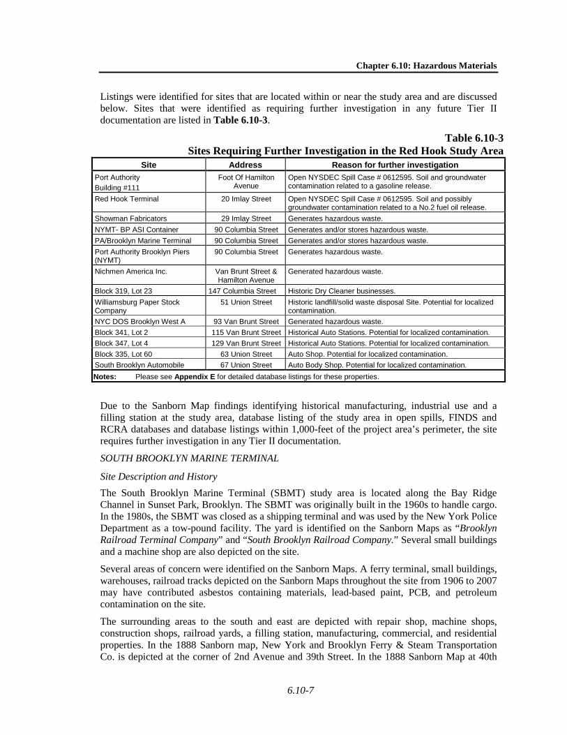
Listings were identified for sites that are located within or near the study area and are discussed below. Sites that were identified as requiring further investigation in any future Tier II documentation are listed in Table 6.10-3.
Table 6.10-3 Sites Requiring Further Investigation in the Red Hook Study Area
Site Address Reason for further investigation Port Authority Building #111
Foot Of Hamilton Avenue
Open NYSDEC Spill Case # 0612595. Soil and groundwater contamination related to a gasoline release.
Red Hook Terminal 20 Imlay Street Open NYSDEC Spill Case # 0612595. Soil and possibly groundwater contamination related to a No.2 fuel oil release.
Showman Fabricators 29 Imlay Street Generates hazardous waste. NYMT- BP ASI Container 90 Columbia Street Generates and/or stores hazardous waste. PA/Brooklyn Marine Terminal 90 Columbia Street Generates and/or stores hazardous waste. Port Authority Brooklyn Piers (NYMT)
90 Columbia Street Generates hazardous waste.
Nichmen America Inc. Van Brunt Street & Hamilton Avenue
Generated hazardous waste.
Block 319, Lot 23 147 Columbia Street Historic Dry Cleaner businesses. Williamsburg Paper Stock Company
51 Union Street Historic landfill/solid waste disposal Site. Potential for localized contamination.
NYC DOS Brooklyn West A 93 Van Brunt Street Generated hazardous waste. Block 341, Lot 2 115 Van Brunt Street Historical Auto Stations. Potential for localized contamination. Block 347, Lot 4 129 Van Brunt Street Historical Auto Stations. Potential for localized contamination. Block 335, Lot 60 63 Union Street Auto Shop. Potential for localized contamination. South Brooklyn Automobile 67 Union Street Auto Body Shop. Potential for localized contamination. Notes: Please see Appendix E for detailed database listings for these properties.
Due to the Sanborn Map findings identifying historical manufacturing, industrial use and a filling station at the study area, database listing of the study area in open spills, FINDS and RCRA databases and database listings within 1,000-feet of the project area’s perimeter, the site requires further investigation in any Tier II documentation.
SOUTH BROOKLYN MARINE TERMINAL
Site Description and History The South Brooklyn Marine Terminal (SBMT) study area is located along the Bay Ridge Channel in Sunset Park, Brooklyn. The SBMT was originally built in the 1960s to handle cargo. In the 1980s, the SBMT was closed as a shipping terminal and was used by the New York Police Department as a tow-pound facility. The yard is identified on the Sanborn Maps as “Brooklyn Railroad Terminal Company” and “South Brooklyn Railroad Company.” Several small buildings and a machine shop are also depicted on the site.
Several areas of concern were identified on the Sanborn Maps. A ferry terminal, small buildings, warehouses, railroad tracks depicted on the Sanborn Maps throughout the site from 1906 to 2007 may have contributed asbestos containing materials, lead-based paint, PCB, and petroleum contamination on the site.
The surrounding areas to the south and east are depicted with repair shop, machine shops, construction shops, railroad yards, a filling station, manufacturing, commercial, and residential properties. In the 1888 Sanborn map, New York and Brooklyn Ferry & Steam Transportation Co. is depicted at the corner of 2nd Avenue and 39th Street. In the 1888 Sanborn Map at 40th

Cross Harbor Freight Program
6.10-8
Street and First Avenue, the W. Johns Manufacturing Company and Phenix Chemical Company are depicted including asbestos factory, crystal shed, sulfuric acid storage and acid chambers. Also in 1888 between 40th and 41st street, numerous large tanks are depicted in what appears to be an oil refinery. The W. Johns Manufacturing Co. is later depicted as “The H. W. Johns-Manville Co. Mfrs of Asbestos Products.” In the 1926 Sanborn map, Bush Terminal Co. is depicted to the southeast of the site. To the southeast of the site, 2nd Avenue is depicted in the 1906 Sanborn Map with 39th Street bordering the site to the south and Gowanus Bay bordering the site to the northwest. The 1951 to 1995 Sanborn Maps depict “NYC Transit System Freight Dept” on the site and “NY City Transit System BMT Division Bus Mechanical Department” with a filling station to the south of the study area at 2nd Avenue and 37th Street. The 2001 Sanborn Map depicts a Costco and parking lot to the south of the study area at 2nd Avenue and 37th Street. The 1965 to 1995 Sanborn Maps depicts the study area as Universal Terminal and Stevedoring Co. with cargo storage, container storage and a small electrical building at 37th Street. A highway department laboratory is depicted on the study area at 31st street in the 1965 map. The NYC Sanitation Garage is depicted on the study area starting with the 1951 Sanborn Map. The 2001 Sanborn Maps depicts the study area as Used Car Sales with container storage and a small electrical building at 37th Street. Several auto repair facilities depicted along the surrounding streets may be sources of gasoline, petroleum and hazardous soil and groundwater contamination. The EDR-City Directory Abstract indicates that trucking companies, manufacturing, laundry facilities have been located in surrounding areas.
Records Review A review of environmental records for the SBMT study area was accomplished by accessing the databases of federal and state regulatory agencies and compiling the site listings contained therein. Listings were identified for sites that are located within or near the study area and are discussed below. Sites that were identified as requiring further investigation in any future Tier II documentation are listed in Table 6.10-4.
Table 6.10-4 Sites Requiring Further Investigation in the SBMT Study Area
Site Address Reason for further investigation International Term Operating Co Inc. 1-39th Street
Terminal Identified as Large Quantity Generator.
Global Auto Body Inc. 41 39th Street Identified as a former Auto Station. Dept Ports Intl Trade & Comm. 39th Street Identified as Large Quantity Generator of PCB oil with notices of violations. RAIL EXTENSION TO SIMS PROPERTY
39th Street And 1st Avenue
Identified in the FINDS database.
Con Edison – Manholes 1st and 2nd Avenues Various
Locations
Identified as Large Quantity Generator of Lead and PCB waste.
Interdynamics, Inc. 80 39th Street Identified in chemical bulk storage tank, RCRA-CESQG, SSTS, FINDS, NY MANIFEST, NY Spills, US AIRS databases.
Notes: Please see Appendix E for detailed database listings for these properties.
Due to the Sanborn Map findings identifying the historical use of the site as a cargo terminal with railroad yard and surrounding areas depicted with asbestos manufacturing, a filling station, auto repair facility, and database listings within 1,000-feet of the study area’s perimeter including spills and UST sites, the site requires further investigation in any Tier II documentation.

Chapter 6.10: Hazardous Materials
6.10-9
51ST STREET YARD
Site Description and History The 51st Street Yard study area consists of approximately 10 acres of railroad property. Based on satellite images from 2008, the study area appears to have six approximately 1,000-foot long locomotive layups that are in use. An approximately 22,000-square foot building is also located in the northeast corner of the study area. The land immediately adjacent to the study area is used for commercial and industrial purposes, although residential housing areas are present within approximately 1,500 to 2,000 feet of the study area. The study area and surrounding areas include urban land which was created by landfilling between four piers that were part of the former Bush Terminal warehouse complex. The remaining pier structures are dilapidated and extend 600 to 800 feet into Gowanus Bay from the existing fill areas. The study area is currently fenced to prevent public access.
Bush Terminal, also known as Industry City, is a large historic complex of piers (mostly defunct), docks, warehouses, factories, and rail sidings on 200 acres of the waterfront in the Sunset Park area of Brooklyn. It was designed as a massive intermodal shipping, warehousing, and manufacturing center and rail-marine terminal and was the first of its kind in New York and the largest of its kind in the world. There had only been one warehouse on the site in 1890, and before that, the land contained an oil refinery belonging to Bush & Denslow Company. Standard Oil bought this refinery in the 1880s and dismantled it, but Bush Terminal continued as a heavy manufacturer through both world wars and up to the present day. Prior to 1974, Bush Terminal was still an active port facility, with vessels that docked between its piers. In 1974, the City of New York Department of Ports and Terminals hired a private company to fill the spaces between Piers 1 through 4 (directly adjacent to the study area) to make space for parking shipping containers. Filling however was halted in 1978 after reports of environmental violations. New York City officials later learned that toxic wastes including oils, oil sludges, and wastewaters had been dumped at the site, making the four piers a Brownfield. In 2006, Mayor Michael Bloomberg and Governor George Pataki announced a $36 million plan to clean up and redevelop the Bush Terminal piers. The plan included a $17.8 million grant from the State of New York which was the largest single grant New York State had ever awarded to clean a Brownfield site.
Records Review A review of environmental records for the 51st Street Yard site was accomplished by accessing the databases of federal and state regulatory agencies and compiling the site listings contained therein. Numerous listings were identified for sites that are located within or near the study area and are discussed below.
As summarized in Table 6.10-5, four sites were identified that would require further investigation in any future Tier II documentation.
Table 6.10-5 Sites Requiring Further Investigation in the 51st Street Yard Study Area
Site Address Reason for further investigation Bush Terminal -- Extensive site listings within 400-feet of the study area’s perimeter. Adjacent sites
include former large quantity hazardous waste generators, closed petroleum bulk storage tanks, reported underground storage tank leaks and spills, a potentially active gasoline spill, buried drums of pesticides found, heavy soil contamination, etc.
Bush Terminal landfill Piers 1-4 -- Database listed as an Environmental Remediation Program (ERP) site. Listed hazardous waste site adjacent.
140 43rd Street 140 43rd Street Listed as open petroleum spill. Cross Harbor Railroad 4302 First Ave. Petroleum Bulk Storage site. Notes: Please see Appendix E for detailed database listings for these properties.

Cross Harbor Freight Program
6.10-10
Due to the known industrial history of Bush Terminal, the study area being located within a NYS Brownfield Opportunity Area, its close proximity to an active ERP and Hazardous Waste Site, and the extensive site listing uncovered in the environmental database search (including numerous findings of soil contamination, diesel and gasoline USTs and spills, and prior CERCLIS action with subsequent removal of hazardous soil from the study area and NYS Open Petroleum Spills), the site requires further investigation in any future Tier II documentation.
65TH STREET YARD
Site Description and History The 65th Street Yard study area is located between 64th and 66th Streets, west of Second Avenue. It forms the terminus of the Long Island Rail Road's (LIRR) Bay Ridge freight line along the Brooklyn waterfront.
When the Bay Ridge Line was built in 1876, the study area was a busy passenger ferry terminal connecting Bay Ridge to lower Manhattan, which was then the heart of New York City. Passenger service ended on the Bay Ridge line in 1924, although this remained a yard for the freight line. The yard was abandoned during the 1980s and 1990s before being renovated and reopened in 1999 as a storage, switching, and intermodal transfer yard.
Four float bridges occupied the shoreline from the turn of the century until the late 1970s/early 1980s. It is likely that metal containing paints, oils, and degreasers associated with the maintenance of train cars and the transfer facility were used extensively on the site since its earliest development. Historical aerial photographs indicate that most structures on the property were demolished by 1992; only the pump house remains today. The neighboring Brooklyn Army Terminal was a former U.S. Army supply base used for the storage and shipment of military supplies from before 1926 to the 1980s. A small incinerator was located at the Brooklyn Army Terminal on its southern boundary with 65th Street Yard, from before 1951 to approximately 1991. Three large oil tanks were historically located on Pier 1A (currently the New York City Police Department Harbor Unit) from approximately the 1920s through the 1990s. Structures labeled as paint, oil, and cask oil storage were shown on the maps east of the oil tanks.
The topography of the study area slopes to the west, toward New York Harbor, with the surrounding topography sloping generally to the north-northwest. The study area is located at approximately 14 feet above mean sea level (amsl).
Records Review A review of environmental records for the 65th Street Yard was accomplished by accessing the databases of federal and state regulatory agencies and compiling the site listings contained therein. Numerous listings were identified for sites that are located within or near the study area and are discussed below. As summarized in Table 6.10-6, nine sites were identified that would require further investigation in any future Tier II documentation.
Due to several businesses in the area being listed in regulatory databases, several USTs present in the study area, and the study area’s close proximity to the Owl’s Head Water Pollution Control Plant (WPCP), the study area would require further investigation as part of any future Tier II documentation.

Chapter 6.10: Hazardous Materials
6.10-11
Table 6.10-6 Sites Requiring Further Investigation in the 65th Street Yard Study Area
Site Address Reason for further investigation Brooklyn Army Terminal -- Elevated concentrations of lead and other heavy metals may be
present in structures and surrounding soil IEH Corporation 140 58th Street Manufactures hazardous chemicals and generates hazardous
waste Vahl, Inc. 6401 2nd Avenue UST on site
57 Phat (sic) 2nd Service Statio
5701 2nd Avenue UST on site
Marino Polishing and Plating
244 59th Street UST on site
Blue Diamond Fuel Oil Group
243 57th Street UST on site
L & S Service Center, Inc. 301 65th Street UST on site Liverpool Industries 162 57th Street Listed in several databases for exceeding regulatory levels for
barium Owls Head Water Pollution
Control Plant -- Potential for localized contamination
Notes: Please see Appendix E for detailed database listings for these properties.
EAST NEW YORK
Site Description and History The East New York Yard study area encompasses a stretch of land approximately 3.1-miles long which follows the LIRR Bay Ridge Branch from East New York Avenue at the northern terminus to Kings Highway at the south-western terminus. The study area is located between Junius Street and Van Sinderen Street from East New York Avenue down to New Lots Avenue. After New Lots Avenue, the study area narrows to 100-feet in width and curves southwest to follow the LIRR Bay Ridge Branch to Kings Highway at the southern terminus.
The land uses closest to the study area are predominantly industrial, manufacturing, utility and transportation facilities. In certain areas commercial facilities (including laundromats, auto-related services, and gas stations) and mixed-use and multi-family residential properties are prevalent. It is likely that the soil and/or groundwater in the study area have been affected by petroleum and/or other contamination due to the numerous auto related facilities, laundromats, gas stations, manufacturing, utility and industrial facilities in the area. Lead paint may be present on the elevated track and other steel structures throughout the study area. Since the painted surfaces of steel structures are presumed to be in poor condition and peeling; and since such structures have been in place for many years, elevated concentrations of lead may be present in soil under these structures.
Structures and property uses within the study area include LIRR layup tracks, the New Lots Avenue, Livonia Avenue, Sutter Avenue and Atlantic Avenue stations for New York City Transit (NYCT) L subway line services, the BM Auto Shop, Mastermade Furniture Corporation, Food Bazaar Supermarket, a paved parking lot and an open unused paved lot, Love Auto Repair and Body Shop, EP Certified Engine Rebuilders, Futon Frame Warehouse, Aliyah’s Gold Exchange and Gershow Recycling Corporation. Several areas with varying amounts of foliage including some areas with mature stands of trees are located north and south of the tracks from Kings Highway to Linden Boulevard, and along the western side of Van Sinderen Avenue and

Cross Harbor Freight Program
6.10-12
the NYCT L subway line tracks. In addition, NYCT Nos. 2, 3, 4, and 5 subway lines run along Livonia Avenue.
The topography of the study area is higher to the north and generally slopes to the south-southeast. The average elevation is approximately 30-feet amsl.
A review of Sanborn Fire Insurance Maps indicates the historic use of the study area and surrounding area as follows:
• Sanborn Fire Insurance Maps show that the study area has been developed with rail tracks since at least 1887. Adjacent and surrounding lots consisted of vacant lots, residential dwellings, churches, a lumberyard, a drain pipe factory, and a brick yard and a lime yard.
• Sanborn Maps from 1907 show the study area further developed with the LIRR freight depot, additional rail tracks, a coal company, and a lumberyard. Adjacent and surrounding properties in 1907 consisted of more residences, an iron works, a hospital, and an ice company.
• Sanborn Maps from 1928 depict another coal company and an ash and garbage station within the study area. Adjacent properties in 1928 include another coal company, more iron works, multiple garages and filling stations with gasoline tanks, and a marble works.
• By 1950, the ash and garbage station and a coal company were gone from the study area; however, a salt warehouse is now shown on site. Surrounding properties in 1950 included laundry, pumping stations, auto wrecking, contractor storage yards, machine shops, more garages with gasoline tanks, a shipping terminal, and furniture storage.
• Sanborn Maps from 1966-1968 show the study area developed with industries including a scrap iron facility, auto junking, electric plating, auto servicing, auto body manufacturing, tire sales and service, and a gasoline filling station.
• From 1980 to 1986 an auto junk yard was operating within the study area and the tire sales business was gone. Filling stations, coal storage, spray painting, scrap metal, auto body, manufacturing and auto junk yards were observed in the study area. In addition, the Metropolitan Bottling Company of New York had a facility south of the tracks in the study area. Brooklyn Union Gas Company is observed north of the tracks within the study area on the 1980 Sanborn Maps.
• In 1991, the filling station was absent from the study area. From 1928 through 2007 multiple garages with gasoline tanks, auto body shops, metal works, and auto repair shops are depicted on the adjacent and surrounding properties.
Records Review A review of environmental records for the East New York Yard study area was accomplished by accessing the databases of federal and state regulatory agencies and compiling the site listings contained therein.
The East New York Yard study area was identified under 10 site listings in the regulatory databases searched. In addition, the regulatory database review revealed extensive site listings within 1,000-feet of the study area’s perimeter. Sites that were identified as requiring further investigation in any future Tier II documentation are listed in Table 6.10-7.

Chapter 6.10: Hazardous Materials
6.10-13
Table 6.10-7 Sites Requiring Further Investigation in the East New York Yard Study Area
Site Address Reason for further investigation 417 Junius Street 417 Junius Street Parking lot listed in various databases as a large quantity
generator of hazardous material. Three NYCT L Subway Line Stations
Livonia Avenue and Van Sinderen Avenue; Livonia Avenue and Junius
Street; and New Lots Avenue and Van Sinderen Avenue
Listed in various databases as generators of large amounts of hazardous lead-containing material.
New York City Transit Authority (NYCTA) Linden Shop
1407 Linden Blvd, 1500 Linden Blvd, and Rockaway Avenue / Linden Blvd
Listed on various databases for small quantity releases of heating oil and generating large quantities of hazardous lead containing material.
663 E 56th Street 663 E 56th Street Known release of diesel fuel from tank overfill. New York City Economic Development Corporation
181 Powell Street Listed in various databases for potential contamination.
Glenmore Plaza 108 Christopher Avenue Listed in various databases as having contaminated soils. Wrought Originals 38 Van Sinderen Avenue Listed in various databases as having contaminated soils. Canarsie Service Station, located at 8424 Ditmas Avenue
8424 Ditmas Avenue Database listed in connection with PCB waste.
Belmont Station Belmont, Williams, Alabama, and Sutter Avenues
Manufactured Gas Plant.
Notes: Please see Appendix E for detailed database listings for these properties.
Due to the Sanborn map findings, indicating the East New York Yard study area as historically containing a coal storage yard, filling stations, scrap metal and auto junk yards; and the extensive site listings uncovered in the environmental database search (including hazardous waste generators, leaking storage tanks, spill sites, PCB waste sites, a dry cleaners, and an MGP site), the site requires further investigation in any future Tier II documentation.
MASPETH YARD
Site Description and History The Maspeth Yard study area contains an approximately 0.86-mile stretch of railroad tracks extending from Maspeth Avenue to the east to the Kosciuszko Bridge to the west and associated area generally extending southwest and south to the Maspeth Creek and Newtown Creek, respectively. The study area contains layup tracks and tracks spanning its northern length, with approximately seven tracks at its widest point, trees and low brush along the tracks, and industrial properties and warehouses to the south.
Within the western end of study area is the vacant 30-acre Phelps Dodge site which is currently inoperable with no structures. Current building and property uses within the remaining portion of the expanded West Maspeth Yard include commercial storefronts and offices, large transfer facilities, the Montauk Branch of the LIRR, auto repair shops, vacant lots, food and beverage distributors, warehouses, and scrap metal processing. Warehouses and other buildings appeared to be in generally poor to good condition. It is likely that these buildings contain asbestos-containing materials and lead based paint.
According to historical Sanborn maps and previous reports, the surrounding areas were occupied by active industrial uses for more than 100 years until manufacturing operations were discontinued in 1983. Historical uses include a sulfuric acid plant, copper refinery, phosphate works, and bulk acid distribution. The Phelps Dodge Refining Corporation occupied the Phelps
Cross Harbor Freight Program
6.10-14
Dodge site within the study area until 1983. The facility was a copper refinery and a production facility for copper sulfate pesticides and copper sulfate pentahydrate. Sanborn maps indicate that buildings and structures at the facility included a copper paste plant, an acid tank with a capacity of 700 tons, two 150,000-gallon fuel storage tanks, transformers, stripping rooms, a Bessemer plant, a smelter operation, and tank rooms. The surrounding area has been in use as industrial, manufacturing or warehouses for the last century. Historic uses at the site include a chemical company, an enameling and stamping company, and various other unidentified manufacturing and warehouse uses.
Records Review A review of environmental records for the Maspeth Yard site was accomplished by accessing the databases of federal and state regulatory agencies and compiling the site listings contained therein. Listings were identified for sites that are located within and near the study area and are discussed below. Sites that were identified as requiring further investigation in any future Tier II documentation are listed in Table 6.10-8.
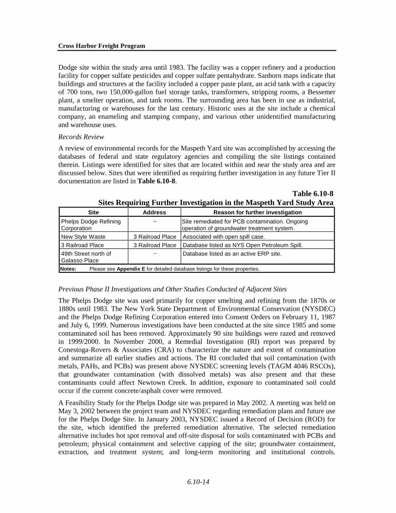
Table 6.10-8 Sites Requiring Further Investigation in the Maspeth Yard Study Area
Site Address Reason for further investigation Phelps Dodge Refining Corporation
-- Site remediated for PCB contamination. Ongoing operation of groundwater treatment system.
New Style Waste 3 Railroad Place Associated with open spill case. 3 Railroad Place 3 Railroad Place Database listed as NYS Open Petroleum Spill. 49th Street north of Galasso Place
-- Database listed as an active ERP site.
Notes: Please see Appendix E for detailed database listings for these properties.
Previous Phase II Investigations and Other Studies Conducted of Adjacent Sites The Phelps Dodge site was used primarily for copper smelting and refining from the 1870s or 1880s until 1983. The New York State Department of Environmental Conservation (NYSDEC) and the Phelps Dodge Refining Corporation entered into Consent Orders on February 11, 1987 and July 6, 1999. Numerous investigations have been conducted at the site since 1985 and some contaminated soil has been removed. Approximately 90 site buildings were razed and removed in 1999/2000. In November 2000, a Remedial Investigation (RI) report was prepared by Conestoga-Rovers & Associates (CRA) to characterize the nature and extent of contamination and summarize all earlier studies and actions. The RI concluded that soil contamination (with metals, PAHs, and PCBs) was present above NYSDEC screening levels (TAGM 4046 RSCOs), that groundwater contamination (with dissolved metals) was also present and that these contaminants could affect Newtown Creek. In addition, exposure to contaminated soil could occur if the current concrete/asphalt cover were removed.
A Feasibility Study for the Phelps Dodge site was prepared in May 2002. A meeting was held on May 3, 2002 between the project team and NYSDEC regarding remediation plans and future use for the Phelps Dodge Site. In January 2003, NYSDEC issued a Record of Decision (ROD) for the site, which identified the preferred remediation alternative. The selected remediation alternative includes hot spot removal and off-site disposal for soils contaminated with PCBs and petroleum; physical containment and selective capping of the site; groundwater containment, extraction, and treatment system; and long-term monitoring and institutional controls.

Chapter 6.10: Hazardous Materials
6.10-15
Remediation activities reportedly began at the site in September 2003. The remediation was anticipated to be completed in 2004, with ongoing groundwater monitoring and treatment.
Due to the Sanborn map findings indicating the former presence of a copper refinery within the study area, part of the study area being located within a NYS Brownfield Opportunity Area, the extensive site listings within 1,000-feet of the study area’s perimeter, including five (5) potentially active LTANKS, the NYS Open Petroleum Spill located at 3 Railroad Place, and an active ERP site adjacent to the study area, the site requires further investigation in any future Tier II documentation.
FRESH POND YARD
Site Description and History Fresh Pond Yard contains numerous tracks running in an east-west direction. Fresh Pond Yard contains the main office of the New York and Atlantic Railroad (NY&A), a small freight railroad, which occupies a doublewide trailer in the center of the yard, a parking lot, and two small storage sheds. Separating the western and eastern portions of Fresh Pond Yard is the NYCT M subway line. The site is nearly devoid of vegetation, except for some brush along the boundaries. Just west of the Fremont Secondary Line bridge overpass along the north side of the yard is a Buckeye Pipeline test line access box and an oil fill for the NY&A office trailer. According to the prior report, several piles of debris and dumped material, including 55-gallon drums of unknown content, were observed throughout the site. Lead paint may be present on the Fremont Secondary Line bridge overpass on the west side of the eastern portion of the yard. Since the painted surfaces of the overpass were in poor condition and peeling, elevated concentrations of lead may be present in soil under this structure. The neighborhood surrounding Fresh Pond Yard is primarily residential. However, a paper products facility and food processing company are located southeast of eastern portion of the yard and warehouses and manufacturing buildings are to the south of the western portion.
The site has been in railroad usage since the late 19th century. Aerial photographs from 1954 indicate that the southern end of the eastern portion was approximately ten tracks across. Aerial photographs from 1966 indicate that warehouses were built over some tracks on the south end of the eastern portion, leaving approximately five tracks still in use. Historical Sanborn atlases indicate the surrounding neighborhood as being primarily residential with some commercial and industrial use to the south and east.
Records Review The study area is listed in the NY Spills, LTANKS and ERNS databases. The three NY Spills database listings for the site are closed. An open LTANKS spill is listed at an auto service facility within the search radius. The ERNS database identified two train derailments and emergency releases of petroleum on the site with no closure date. At least six gasoline stations and auto facilities are listed in the regulatory databases within the search radius.
Phase II Studies Conducted of the Study Area As part of the Final EIS for the Metropolitan Transportation Authority (MTA)/LIRR East Side Access Project, soil sampling was conducted on this site. Six soil borings to 3 feet below grade were advanced and soil samples analyzed. Elevated levels of VOCs (up to 23 ppm total) consisting of trichloroethene and dichloroethene, common chlorinated solvents used in degreasing, were found at one boring location at the eastern portion of the parking lot.

Cross Harbor Freight Program
6.10-16
Due to the database listings on the study area and within 1,000-feet of the study area’s perimeter, prior Phase II findings and observation of an adjacent dry cleaning facility, the site requires further investigation in Tier II.
OAK POINT YARD
Site Description and History The Oak Point Yard study area consists of numerous rail tracks extending from Longwood Avenue to East 142nd Street on the east side of the Bruckner Expressway with several branch lines extending south to Oak Point Avenue. The yard is identified on the Sanborn Maps as “NY New Haven & Hartford Railroad Harlem River Branch” and “NY Westchester & Boston Railroad.” Several sheds and signal towers are also depicted on the site.
Several areas of concern were identified on the Sanborn Maps. Sheds, transformers, signal towers, small buildings, warehouses, tracks, a train station and platforms depicted on the Sanborn Maps throughout the site from 1896 to 2007 may have contributed asbestos containing materials, lead-based paint, PCB and petroleum contamination on the site. The surrounding areas on all sides are depicted with numerous filling stations, auto and truck repair facilities, auto painting, parking lots, manufacturing, commercial and residential properties. A Consolidated Edison substation is depicted to the north of the site. Whitlock Avenue is depicted to the north of the site in the 1915 Sanborn Map and is not depicted in the 1950 Sanborn Map. Bruckner Boulevard is depicted on the 1915 Sanborn Map to the north of Whitlock Avenue and is depicted on the 1950 Sanborn as widened to encompass the area previously shown as Whitlock Avenue. The 1950 Sanborn Map depicts “Consumers Fuel Distribution Corp.” and a coal yard on the study area. The 1950 through 1981 Sanborn Maps depict an area of plasterboard manufacturing buildings, storage silos, lab, boiler house, pump house and six to eight 20,000 gallon underground fuel oil tanks on the study area near the intersection of Oak Point Avenue and Barry Street. The Sanborn Maps depict the study area between Barry Street and Cabot Street north of Oak Point Avenue improved with an alloy foundry, lumber yard, auto wrecker, plastic manufacturing, garage, and repair facility with two 550 gallon underground storage tanks. Numerous filling stations, auto and truck repair facilities, auto painting, parking lots and manufacturing sites depicted along the surrounding streets may be sources of gasoline, petroleum and hazardous soil and groundwater contamination. The EDR-City Directory Abstract indicates that auto repair, salvage and manufacturing facilities have been located in surrounding areas since at least 1965. The elevated steel structure Bruckner Expressway, Leggett Avenue and East 149th Street may have contributed to lead and other heavy metal contamination to the surrounding soils.
Records Review A review of environmental records for the Oak Point Yard study area was accomplished by accessing the databases of federal and state regulatory agencies and compiling the site listings contained therein. Listings were identified for sites that are located within or near the study area and are discussed below. Sites that were identified as requiring further investigation in any future Tier II documentation are listed in Table 6.10-9.
Chapter 6.10: Hazardous Materials
6.10-17
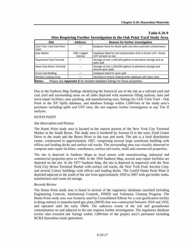
Table 6.10-9 Sites Requiring Further Investigation in the Oak Point Yard Study Area
Site Address Reason for further investigation CSX Train Yard Oak Point Yard
--- Database listed for diesel spills and other potential contamination.
Gas Station 1081 Leggett Avenue
Database listed for soil contamination from a former UST. Active UST present on site.
Stuyvesant Fuel Terminal --- Storage of over 1,000,000 gallons of petroleum storage and an open spill.
Hess Corp Bronx Terminal --- Storage of over 1,000,000 gallons of petroleum storage and several open spills.
Coca Cola Bottling --- Database listed for open spill. Mendon Leasing Corp --- Identified in historic leaking tanks database with open case.
Notes: Please see Appendix E for detailed database listings for these properties.
Due to the Sanborn Map findings identifying the historical use of the site as a railroad yard and coal yard and surrounding areas on all sides depicted with numerous filling stations, auto and truck repair facilities, auto painting, and manufacturing uses, listings for CSX Train Yard – Oak Point in the NY Spills database, and database listings within 1,000-feet of the study area’s perimeter including spills and UST sites, the site requires further investigation in any Tier II analysis.
HUNTS POINT
Site Description and History The Hunts Point study area is located in the eastern portion of the New York City Terminal Market in the South Bronx. The study area is bordered by Avenue D to the west, Food Center Drive to the south and the Bronx River to the east and north. The site is a food distribution center, constructed in approximately 1967, comprising several large warehouse building with offices and loading docks and surface rail tracks. The surrounding area was visually observed to comprise auto repair facilities, warehouses, surface rail tracks, retail and commercial properties.
The site is depicted in Sanborn Maps as local streets with manufacturing, industrial and commercial properties prior to 1969. In the 1950 Sanborn Map, several auto repair facilities are depicted on the site. In the 1977 Sanborn Map, the site is depicted as improved with the New York City Bronx Terminal Market with surface rail tracks, the New York Fruit Auction Corp. and several 2-story buildings with offices and loading docks. The ConEd Hunts Point Plant is depicted adjacent to the south of the site from approximately 1950 to 2007 with gas holder tanks, transformers and waste oil storage.
Records Review The Hunts Point study area is listed in several of the regulatory databases searched including Engineering Controls, Institutional Controls, FINDS and Voluntary Cleanup Program. The Hunts Point study area was formerly used by Consolidated Edison for a coal gasification facility (coking station) or manufactured gas plant (MGP) that was constructed between 1924 and 1932, and operated until the early 1960s. The unknown extent of the soil and groundwater contamination on and adjacent to the site requires further investigation. The regulatory database review also revealed site listings within 1,000-feet of the project area’s perimeter including RCRA hazardous waste generators.

Cross Harbor Freight Program
6.10-18
Listings were identified for sites that are located within or near the study area and are discussed below. Sites that were identified as requiring further investigation in any future Tier II documentation are listed in Table 6.10-10.
Table 6.10-10 Sites Requiring Further Investigation in the SBMT Study Area
Site Address Reason for further investigation Hunts Point 550 Food Center
Drive Identified in Engineering Controls, Institutional Controls, FINDS and Voluntary Cleanup Program databases.
NY Power Auth - Hunts Point Fuel Cell
Coster St & Ryawa Ave
Identified in FINDS and RCRA databases.
Hunts Point Avenue Compressor Station
332 Hunts Point Ave Identified in AIRS database, RCRA Large Quantity Generator.
NYCDEP Hunts Pt - Lafayette & Edgewater
Identified in manifest database.
Con Edison - Hunts Point Works MGP
Between Bronx River, East River, and East Bay Ave
Identified as a former Manufactured Gas Plant.
Notes: Please see Appendix E for detailed database listings for these properties.
Due to the Sanborn Map findings identifying the historical manufacturing and industrial use of the study area, database listing of the study area in Engineering Controls, Institutional Controls, FINDS, Voluntary Cleanup Program, FINDS, RCRA, and AIRS databases and database listings within 1,000-feet of the project area’s perimeter, including the ConEd Hunts Point Plant, the site requires further investigation in any Tier II analysis.
LONG ISLAND
As described in Chapter 4, “Alternatives,” for the purposes of this Tier I EIS, the Long Island Rail-Truck Inter Modal (LITRIM) facility (i.e., the Pilgrim Intermodal Terminal), proposed by New York State Department of Transportation (NYSDOT), and the Brookhaven Rail Terminal serve as illustrative examples for the determination of potential environmental effects resulting from Cross Harbor Freight Program (CHFP) operation in Nassau/Suffolk. These two sites, shown in Chapter 4, “Alternatives” (Figure 4-12), are not the only possible sites for the Long Island Facility, but rather sites that are generally representative of potential environmental effects on Long Island due to the operation of project alternatives.
Pilgrim Intermodal Terminal The Pilgrim Intermodal Terminal study area is located approximately one-mile north of the LIRR right-of-way, about ½-mile east of the Deer Park LIRR station, in the Town of Brentwood, on the Main Line/Ronkonkoma Branch. The study area consists of approximately 105 acres of land on property previously occupied by the Pilgrim State Psychiatric Hospital. Structures within the study area include a former incinerator building and an abandoned wastewater chlorination building. The portion of the Pilgrim State Psychiatric Hospital that abuts the study area to the northeast is occupied by a former power plant. This area included a coal storage yard, land disposal of coal ash, and petroleum bulk storage. The study area is presently vacant, and the majority of the site is disturbed and was formerly used for sanitary recharge beds for the original Pilgrim hospital. Prior uses of the study area by the Pilgrim State Psychiatric Hospital include a sanitary wastewater treatment system, stormwater retention basins (still active), an outdoor solid waste burn pit, an incinerator building, and land disposal of coal ash, medical waste, and general
Chapter 6.10: Hazardous Materials
6.10-19
refuse. Nearby sites include hazardous waste generators, chemical bulk storage sites, and a former spills site. Due to the known history of the study area, particularly the prior uses of the study area by the Pilgrim State Psychiatric Hospital, and the current uses and relative proximity of nearby sites within the Hartland Business Center, the Pilgrim Intermodal Terminal study area would require further investigation if a intermodal yard was to be developed on the site.
Brookhaven Rail Terminal The Suffolk County Department of Public Works, located near the Brookhaven Rail Terminal, is reported to have soil contamination discovered during the removal of a waste oil UST. Interstate 495 is adjacent to the study area and is listed as a hazardous waste generator of lead waste. Lead paint may have been present on structural steel of Interstate 495 and other steel structures throughout the study area. Since the painted surfaces of the steel structures are presumed to have been in poor condition and peeling, elevated concentrations of lead and other heavy metals may be present in soil under these structures.
Due to the presence of railroad tracks on the study area, adjacent sites listed as hazardous waste generators and spill sites, and the area near Interstate 495, the Brookhaven Rail Terminal would require further investigation if an intermodal yard was to be developed on the site.
D. POTENTIAL EFFECTS FROM THE PROJECT ALTERNATIVES The presence of hazardous materials can threaten human health or the environment only when exposure to those materials occurs. The greatest potential for exposure to any constituent of concern would be during construction, especially those activities related to excavation, storage, transport and disposal of potentially contaminated soil. Many of the contaminants tend to be bound to the soil and are not particularly mobile, making airborne dust the main pathway for contaminants to reach nearby residents or construction workers. Contaminated groundwater, if encountered during deep excavation or dewatering, would be an additional potential pathway to exposure, particularly for construction workers in the area. Work in soil, including grading, digging, excavating, mining, and boring, would have the greater potential to encounter contaminated materials. This could include both contaminated soil and contaminated groundwater. In the areas where construction in hard rock would occur, the project might encounter contaminated groundwater seeping through the rock, but the overall potential to encounter contamination in rock is less than in soil.
The existing conditions review of the project study areas identified the possibility of contaminated soil and groundwater at several locations where construction would be required for the project alternatives. This section addresses the potential adverse effects from construction, demolition and rehabilitation activities associated with the Build Alternatives. The section also briefly describes the potential for adverse effects during the operation of the Build Alternatives.
OPERATIONAL EFFECTS
NO ACTION ALTERNATIVE
The No Action Alternative includes some undertakings that are part of the overall CHFP, such as the Greenville Yard Repair and Replacement Project and improvements to 65th Street Yard. A separate set of environmental review processes have been completed for the Greenville Yard project, which included an assessment of potential impacts from hazardous materials.
Cross Harbor Freight Program
6.10-20
Operational activities related to other projects identified as part of the No Action Alternative are not part of the CHFP; however, these activities may affect hazardous materials that may be present in the APEs.
WATERBORNE ALTERNATIVES
Enhanced Railcar Float Alternative The transportation of hazardous materials on freight rail lines is regulated by the U.S. Department of Transportation (USDOT) as outlined in 49 CFR Parts 107, 130, 171-174, and 178-180. These regulations define what constitutes a hazardous material; operating requirements for transporters of hazardous materials, including procedures to follow to protect public and worker health; training methods; and proper packaging, labeling, and manifest procedures. The regulations also contain provisions for emergency response in the event of an accidental spill or release of material.
The operation of the termini and support facilities associated with this alternative and associated equipment would include a variety of fuels, lubricants, and oils. The proper use, storage, and disposal of these materials are covered by numerous applicable city, state, and federal regulations. At termini near the waterfront, additional procedures would be used to ensure that hazardous materials do not contaminate groundwater or surface water.
The waterborne transportation of hazardous materials is regulated by the U.S. Coast Guard (USCG). The USCG regulates the transportation of hazardous materials that are loaded or carried on board a vessel without benefit of containers or labels and received and handled by the vessel without mark or count. Solid hazardous materials cargoes listed in 46 CFR 148.01-7 Table of Permitted Cargoes may be transported in bulk on board vessels if they comply with the regulations in 46 CFR 148.01. A petition for authorization to transport an unlisted cargo or to use alternative procedures must be submitted to the USCG. If there is a spillage or discharge of a reportable quantity (RQ) from a single package or a transport vehicle if not packaged, the U.S. Coast Guard and National Response Center must be contacted upon discovery of the incident.
The waterborne transportation of hazardous waste transporters is also regulated by 40 CFR 260.10. This includes transporting hazardous waste from a generator's site to a facility that can recycle, treat, store, or dispose of the waste. Requirements for transporters include (see also 40 CFR 263) obtaining an EPA Identification number, complying with the manifest system, and responding appropriately to hazardous waste discharges. Waterborne hazardous materials must also be in compliance with the Globally Harmonized System of Classification and Labeling of Chemicals (GHS). The GHS establishes agreed hazard classification and communication provisions with explanatory information on how to apply the system. Waterborne hazardous materials must be in compliance with the New York Code of Rules and Regulations (NYCRR), Title 6, Chapter III, 370-376 Hazardous Waste Management Regulations.
With the implementation of these procedures, no impacts from the operation of this alternative would be expected.
Truck Float Alternative The operation of the termini and support facilities associated with this alternative and associated equipment would include a variety of fuels, lubricants, and oils. The proper use, storage, and disposal of these materials are covered by numerous applicable city, state, and federal regulations. At termini near the waterfront, additional procedures would be used to ensure that hazardous materials do not contaminate groundwater or surface water.

Chapter 6.10: Hazardous Materials
6.10-21
The transportation of hazardous materials by truck is regulated by requirements in the federal hazardous materials transportation law (49 U.S.C. 5101 et seq.). The regulations require representation that a hazardous material is present in a package, container, rail car, aircraft, motor vehicle or vessel. The regulations also cover the manufacture, fabrication, marking, maintenance, reconditioning, repairing or testing of a package or container which is represented, marked, certified or sold for use in the transportation of hazardous materials (49 CFR 171.1(a)).
The transportation of hazardous materials by truck is also regulated by 40 CFR 260.10 and must also be in compliance with the Globally Harmonized System of Classification and Labeling of Chemicals (GHS), as discussed above in the waterborne transportation section. Hazardous materials transported by truck must also be in compliance with USDOT regulatory classification system. On the state level, the New York State Environmental Conservation Law requires that anyone engaged in the transportation of regulated waste generated or disposed of within New York State must possess a valid New York State Part 364 Waste Transporter Permit. Trucked hazardous materials must be in compliance with the New York Code of Rules and Regulations (NYCRR), Title 6, Chapter III, 370-376 Hazardous Waste Management Regulations. Hazardous materials transported by truck in New York City must comply with Section 2702–02 of Title 3 of the Rules of the City of New York. Hazardous materials transported by truck in New Jersey must comply with the New Jersey Bureau of Solid & Hazardous Waste Regulation. This regulation ensures that hazardous waste is collected, transported and disposed of in an environmentally acceptable manner and in a competitive marketplace. The applicable New Jersey regulations are Solid Waste Management Act (N.J.S.A. 13:1E-1 et seq.) and the Solid Waste Utility Control Act (N.J.S.A. 48:3-1 et seq., N.J.S.A. 48:13A-1 et seq., N.J.A.C. 7:26-1 et seq., N.J.A.C. 7:26G-1 et seq., and N.J.A.C. 7:26H-1 et seq.).
With the implementation of these procedures, no impacts from the operation of this alternative would be expected.
Truck Ferry Alternative Potential impacts from the operation of this alternative would be identical to the Truck Float Alternative, discussed above. The operation of the termini and support facilities associated with this alternative and associated equipment would include a variety of fuels, lubricants, and oils. The proper use, storage, and disposal of these materials are covered by numerous applicable city, state, and federal regulations. At termini near the waterfront, additional procedures would be used to ensure that hazardous materials do not contaminate groundwater or surface water. With the implementation of these procedures, no impacts from the operation of this alternative would be expected.
The transportation of hazardous materials by truck is regulated by requirements in the federal hazardous materials transportation law (49 U.S.C. 5101 et seq.). The regulations require representation that a hazardous material is present in a package, container, rail car, aircraft, motor vehicle or vessel. The regulations also cover the manufacture, fabrication, marking, maintenance, reconditioning, repairing or testing of a package or container which is represented, marked, certified or sold for use in the transportation of hazardous materials (49 CFR 171.1(a)).
The transportation of hazardous materials by truck is also regulated by 40 CFR 260.10 and must also be in compliance with the Globally Harmonized System of Classification and Labeling of Chemicals (GHS), as discussed above in the waterborne transportation section. Hazardous materials transported by truck must also be in compliance with USDOT regulatory classification system. On the state level, the New York State Environmental Conservation Law requires that anyone engaged in the transportation of regulated waste generated or disposed of within New

Cross Harbor Freight Program
6.10-22
York State must possess a valid New York State Part 364 Waste Transporter Permit. Trucked hazardous materials must be in compliance with the New York Code of Rules and Regulations (NYCRR), Title 6, Chapter III, 370-376 Hazardous Waste Management Regulations. Hazardous materials transported by truck in New York City must comply with Section 2702–02 of Title 3 of the Rules of the City of New York. Hazardous materials transported by truck in New Jersey must comply with the New Jersey Bureau of Solid & Hazardous Waste Regulation. This regulation ensures that hazardous waste is collected, transported and disposed of in an environmentally acceptable manner and in a competitive marketplace. The applicable New Jersey regulations are Solid Waste Management Act (N.J.S.A. 13:1E-1 et seq.) and the Solid Waste Utility Control Act (N.J.S.A. 48:3-1 et seq., N.J.S.A. 48:13A-1 et seq., N.J.A.C. 7:26-1 et seq., N.J.A.C. 7:26G-1 et seq., and N.J.A.C. 7:26H-1 et seq.).
With the implementation of these procedures, no impacts from the operation of this alternative would be expected.
Lift On-Lift Off (LOLO) Container Barge Alternative Hazardous materials impacts that may result from this alternative are nearly identical to those identified above for the other Waterborne Alternatives. The operation of the termini and support facilities associated with this alternative and associated equipment would include a variety of fuels, lubricants, and oils. The proper use, storage, and disposal of these materials are covered by numerous applicable city, state, and federal regulations. At termini near the waterfront, additional procedures would be used to ensure that hazardous materials do not contaminate groundwater or surface water.
With the implementation of these procedures, no impacts from the operation of this alternative would be expected.
Roll On-Roll Off (RORO) Container Barge Alternative Hazardous materials impacts that may result from this alternative are nearly identical to those identified above for the other Waterborne Alternatives. The operation of the termini and support facilities associated with this alternative and associated equipment would include a variety of fuels, lubricants, and oils. The proper use, storage, and disposal of these materials are covered by numerous applicable city, state, and federal regulations. At termini near the waterfront, additional procedures would be used to ensure that hazardous materials do not contaminate groundwater or surface water.
With the implementation of these procedures, no impacts from the operation of this alternative would be expected.
RAIL TUNNEL ALTERNATIVES
Rail Tunnel Alternative The transportation of hazardous materials on freight rail lines is regulated by USDOT as outlined in 49 CFR Parts 107, 130, 171-174, and 178-180. These regulations define what constitutes a hazardous material; operating requirements for transporters of hazardous materials, including procedures to follow to protect public and worker health; training methods; and proper packaging, labeling, and manifest procedures. The regulations also contain provisions for emergency response in the event of an accidental spill or release of material.
The operation of the support facilities yards associated with this alternative and associated equipment would include a variety of fuels, lubricants, and oils. The proper use, storage, and disposal of these materials are covered by numerous applicable city, state, and federal

Chapter 6.10: Hazardous Materials
6.10-23
regulations. At rail yard locations near the waterfront, additional procedures would be used to ensure that hazardous materials do not contaminate groundwater or surface water.
With the implementation of these procedures, no impacts from the operation of this alternative would be expected.
Rail Tunnel with Shuttle (“Open Technology”) Service Alternative The transportation of hazardous materials on freight rail lines is regulated by USDOT as outlined in 49 CFR Parts 107, 130, 171-174, and 178-180. These regulations define what constitutes a hazardous material; operating requirements for transporters of hazardous materials, including procedures to follow to protect public and worker health; training methods; and proper packaging, labeling, and manifest procedures. The regulations also contain provisions for emergency response in the event of an accidental spill or release of material.
The operation of the support facilities yards associated with this alternative and associated equipment would include a variety of fuels, lubricants, and oils. The proper use, storage, and disposal of these materials are covered by numerous applicable city, state, and federal regulations. At rail yard locations near the waterfront, additional procedures would be used to ensure that hazardous materials do not contaminate groundwater or surface water.
With the implementation of these procedures, no impacts from the operation of this alternative would be expected.
Rail Tunnel with Chunnel Service Alternative The transportation of hazardous materials on freight rail lines is regulated by USDOT as outlined in 49 CFR Parts 107, 130, 171-174, and 178-180. These regulations define what constitutes a hazardous material; operating requirements for transporters of hazardous materials, including procedures to follow to protect public and worker health; training methods; and proper packaging, labeling, and manifest procedures. The regulations also contain provisions for emergency response in the event of an accidental spill or release of material.
The operation of the support facilities yards associated with this alternative and associated equipment would include a variety of fuels, lubricants, and oils. The proper use, storage, and disposal of these materials are covered by numerous applicable city, state, and federal regulations. At rail yard locations near the waterfront, additional procedures would be used to ensure that hazardous materials do not contaminate groundwater or surface water.
With the implementation of these procedures, no impacts from the operation of this alternative would be expected.
Rail Tunnel with Automated Guided Vehicle (AGV) Technology Alternative The transportation of hazardous materials on freight rail lines is regulated by the USDOT as outlined in 49 CFR Parts 107, 130, 171-174, and 178-180. These regulations define what constitutes a hazardous material; operating requirements for transporters of hazardous materials, including procedures to follow to protect public and worker health; training methods; and proper packaging, labeling, and manifest procedures. The regulations also contain provisions for emergency response in the event of an accidental spill or release of material.
The operation of the support facilities yards associated with this alternative and associated equipment would include a variety of fuels, lubricants, and oils. The proper use, storage, and disposal of these materials are covered by numerous applicable city, state, and federal

Cross Harbor Freight Program
6.10-24
regulations. At rail yard locations near the waterfront, additional procedures would be used to ensure that hazardous materials do not contaminate groundwater or surface water.
With the implementation of these procedures, no impacts from the operation of this alternative would be expected.
Rail Tunnel with Truck Access Alternative The transportation of hazardous materials on freight rail lines is regulated by USDOT as outlined in 49 CFR Parts 107, 130, 171-174, and 178-180. These regulations define what constitutes a hazardous material; operating requirements for transporters of hazardous materials, including procedures to follow to protect public and worker health; training methods; and proper packaging, labeling, and manifest procedures. The regulations also contain provisions for emergency response in the event of an accidental spill or release of material.
The operation of the support facilities yards associated with this alternative and associated equipment would include a variety of fuels, lubricants, and oils. The proper use, storage, and disposal of these materials are covered by numerous applicable city, state, and federal regulations. At rail yard locations near the waterfront, additional procedures would be used to ensure that hazardous materials do not contaminate groundwater or surface water.
For the Rail Tunnel with Truck Access Alternative, trucks whose load includes hazardous material should comply with the regulations described above under the Truck Float and Truck Ferry Alternatives, as well as the requirements of the Port Authority of New York and New Jersey (PANYNJ) (in a document titled “Hazardous Materials Transportation Regulations at Tunnel and Bridge Facilities”); trucks will be subject to inspection prior to entering the tunnel to determine whether such entry would be in violation of rules and regulations. Trucks loaded with a hazardous material will not be allowed to enter the tunnel unless the driver exhibits a Bill of Lading or other shipping paper describing such article by the specific name by which it is known in the “List of Hazardous Materials” contained in Part 172 of the USDOT regulations.
With the implementation of these procedures, no impacts from the operation of this alternative would be expected.
CONSTRUCTION EFFECTS
ENHANCED RAILCAR FLOAT ALTERNATIVE
As noted in Chapter 4, “Alternatives,” this alternative would utilize Greenville Yard as the western terminus; either 51st Street Yard, 65th Street Yard, or Oak Point Yard as the main eastern terminus. 65th Street Yard and 51st Street Yard, Oak Point Yard, and Maspeth would be used to transfer carload freight; East New York would be used for storage and sidings and potentially as a filet/toupee facility; and Fresh Pond Yard for classification and switching.
West-of-Hudson Study Area Greenville Yard Study Area
Work at Greenville Yard under this alternative would comprise augmenting the hydraulic lift bridges installed under the No Action Alternative with a third bridge, and associated track work. Any activities requiring excavation of potentially contaminated soil or dewatering, would occur in the middle of an industrial area that would limit potential exposure to any sensitive uses (e.g., residences, schools, hospitals, parks, etc.). A portion of the Greenville Yard study area has been remediated to remove barium, lead, and PAH contamination that was associated with contaminated fill places on the site between 2001 and 2002. While this remediation would be

Chapter 6.10: Hazardous Materials
6.10-25
completed under the No Action Alternative, any work on the site would be conducted in accordance with appropriate NJDEP site restrictions.
East-of-Hudson Study Area 65th Street Yard
Under this alternative, 65th Street Yard would be expanded. Additional environmental due diligence would be required to assess the potential for additional contamination sources. Land disturbance during yard improvements would require the excavation of soils potentially contaminated with metals, petroleum compounds and solvents, and possible dewatering where contaminated groundwater may be encountered.
51st Street Yard This alternative would include the renovation of the existing float bridge with upgrades to float bridges and tracks connecting the bridge to the 51st Street Yard. It is likely that asbestos-containing building materials and lead-based paint would be encountered during renovation.
East New York Yard Construction activity at East New York Yard under this alternative would be associated with minor increases to clearances and upgrading of tracks, and the addition of two rail sidings. This construction is expected to be limited to the current right of way. Site work may result in disturbance to soils potentially contaminated with PAHs, metals, and petroleum constituents. As noted in Chapter 4, “Alternatives,” East New York may also be used as a filet/toupee operation in which case, work would expand beyond the current right-of-way.
Fresh Pond Yard Proposed improvements to the Fresh Pond Yard include 10,000 feet of track and switches in the upper portion of the yard, sidings for merchandise car storage, and a siding for storage of one intermodal train. Site work may result in disturbance to soils potentially contaminated with PAHs, metals, PCBs, solvents, and petroleum constituents.
Oak Point Yard Under the Enhanced Railcar Float Alternative, Oak Point Yard would be constructed to receive and launch railcar floats, with all associated trackwork required to support operations. Site work may result in disturbance to soils potentially contaminated with PAHs, metals, PCBs, solvents, and petroleum constituents.
Maspeth Yard Under this alternative, Maspeth Yard would be used to handle bulk and intermodal freight. Yard construction would include track and switch work, which would require only minimal excavation, and work associated with minor increases to clearances. Buildings likely to contain asbestos-containing building materials and lead-based paint would have to be assessed and removed before building demolition. Deeper excavations for building foundations or pilings would likely encounter subsurface contamination and groundwater.
TRUCK FLOAT ALTERNATIVE
As noted in Chapter 4, this alternative would utilize Port Newark/Port Elizabeth as the western terminus; that site would be investigated further as part of any future Tier II documentation. The eastern terminus of this alternative would comprise either one of the Brooklyn waterfront facilities (SBMT, 51st Street Yard, 65th Street Yard), one of the Bronx waterfront facilities (Oak Point or Hunts Point), or Maspeth.

Cross Harbor Freight Program
6.10-26
East-of-Hudson Study Area South Brooklyn Marine Terminal (SBMT)
Under this alternative, SBMT could serve as a terminus for the truck float system, which would require the construction of vehicle ramps, truck staging/parking areas, utility, gate/office, and maintenance facility. Construction activity at SBMT under this alternative may result in disturbance to soils potentially contaminated with PAHs, metals, and petroleum constituents.
51st Street Yard Study Area As with the SBMT, construction at this facility to accommodate this alternative would include vehicle ramps, truck staging/parking areas, and associated facilities. Additional environmental due diligence would be required to assess the potential for additional contamination sources at this site. It is likely that asbestos-containing building materials and lead-based paint would be encountered during renovation.
65th Street Yard Study Area The infrastructure required to support the Truck Float Alternative at 65th Street would be similar to SMBT and 51st Street. Additional environmental due diligence would be required to assess the potential for additional contamination sources at this site. Land disturbance during yard improvements would require the excavation of soils potentially contaminated with metals, petroleum compounds and solvents, and possible dewatering where contaminated groundwater may be encountered.
Oak Point Yard Study Area Construction elements at this facility to support this alternative would be similar to those identified above. Additional environmental due diligence would be required to assess the potential for additional contamination sources at this site. Site work may result in disturbance to soils potentially contaminated with PAHs, metals, PCBs, solvents, and petroleum constituents.
Hunts Point Study Area Construction elements at this facility to support this alternative would be similar to those identified above. The alternative would move truck trailers or whole trucks on a vessel to and from Hunts Point Yard in the Bronx. Construction activity under this alternative may result in disturbance to soils potentially contaminated with PAHs, metals, and petroleum constituents.
TRUCK FERRY ALTERNATIVE
Potential impacts from the construction of this alternative would be identical to those identified above for the Truck Float Alternative. As noted in Chapter 4, this alternative would utilize Port Newark/Port Elizabeth as the western terminus; that site would be investigated further as part of any future Tier II documentation. The eastern terminus of this alternative would comprise either one of the Brooklyn waterfront facilities (SBMT, 51st Street Yard, 65th Street Yard), one of the Bronx waterfront facilities (Oak Point or Hunts Point), or Maspeth.
East-of-Hudson Study Area South Brooklyn Marine Terminal (SBMT)
Under this alternative, SBMT could serve as a terminus for the truck ferry system, which would require the construction of vehicle ramps, truck staging/parking areas, utility, gate/office, and maintenance facility. Construction activity at SBMT under this alternative may result in disturbance to soils potentially contaminated with PAHs, metals, and petroleum constituents.

Chapter 6.10: Hazardous Materials
6.10-27
51st Street Yard Study Area As with the SBMT, construction at this facility to accommodate this alternative would include vehicle ramps, truck staging/parking areas, and associated facilities. Additional environmental due diligence would be required to assess the potential for additional contamination sources at this site. It is likely that asbestos-containing building materials and lead-based paint would be encountered during renovation.
65th Street Yard Study Area The infrastructure required to support the Truck Ferry Alternatives at 65th Street would be similar to SMBT and 51st Street. Additional environmental due diligence would be required to assess the potential for additional contamination sources at this site. Land disturbance during yard improvements would require the excavation of soils potentially contaminated with metals, petroleum compounds and solvents, and possible dewatering where contaminated groundwater may be encountered.
Oak Point Yard Study Area Construction elements at this facility to support this alternative would be similar to those identified above. Additional environmental due diligence would be required to assess the potential for additional contamination sources at this site. Site work may result in disturbance to soils potentially contaminated with PAHs, metals, PCBs, solvents, and petroleum constituents.
Hunts Point Study Area Construction elements at this facility to support this alternative would be similar to those identified above. The alternative would move truck trailers or whole trucks on a vessel to and from Hunts Point Yard in the Bronx. Construction activity under this alternative may result in disturbance to soils potentially contaminated with PAHs, metals, and petroleum constituents.
LIFT ON-LIFT OFF (LOLO) CONTAINER BARGE ALTERNATIVE
As noted in Chapter 4, this alternative would utilize Greenville Yard or Port Newark/Port Elizabeth as the western terminus and Brooklyn waterfront facilities (SBMT, 51st Street Yard, 65th Street Yard, or Red Hook Container Terminal)
West-of-Hudson Study Area Greenville Yard Study Area
Any activities requiring excavation of potentially contaminated soil or dewatering, would occur in the middle of an industrial area that would limit potential exposure to any sensitive uses (e.g., residences, schools, hospitals, parks, etc.). A portion of the Greenville Yard study area has been remediated to remove barium, lead, and PAH contamination that was associated with contaminated fill places on the site between 2001 and 2002. While this remediation would be completed under the No Action Alternative, any work on the site would be conducted in accordance with appropriate NJDEP site restrictions.
East-of-Hudson Study Area Red Hook
The alternative would include upgrading the existing container float operation. Construction activity under this alternative may result in disturbance to soils potentially contaminated with PAHs, metals, and petroleum constituents.

Cross Harbor Freight Program
6.10-28
South Brooklyn Marine Terminal (SBMT) Construction activity at SBMT under this alternative, which would be similar to what is described above under Greenville Yard, may result in disturbance to soils potentially contaminated with PAHs, metals, and petroleum constituents.
51st Street Yard Construction activity at 51st Street Yard under this alternative would be similar to what is described above under Greenville Yard. Additional environmental due diligence would be required to assess the potential for additional contamination sources at this site. It is likely that asbestos-containing building materials and lead-based paint would be encountered during renovation.
65th Street Yard Study Area Construction activity at 51st Street Yard under this alternative would be similar to what is described above under Greenville Yard. Additional environmental due diligence would be required to assess the potential for additional contamination sources. Land disturbance during yard improvements would require the excavation of soils potentially contaminated with metals, petroleum compounds and solvents, and possible dewatering where contaminated groundwater may be encountered.
Oak Point Yard Construction activity at this facility under this alternative would be similar to what is described above under Greenville Yard. Additional environmental due diligence would be required to assess the potential for additional contamination sources at this site. Site work may result in disturbance to soils potentially contaminated with PAHs, metals, PCBs, solvents, and petroleum constituents.
Hunts Point Construction activity at this facility under this alternative would be similar to what is described above under Greenville Yard. Additional environmental due diligence would be required to assess the potential for additional contamination sources at this site. Construction activity under this alternative may result in disturbance to soils potentially contaminated with PAHs, metals, and petroleum constituents.
ROLL ON-ROLL OFF (RORO) CONTAINER BARGE ALTERNATIVE
As noted in Chapter 4, this alternative would utilize Port Newark/Port Elizabeth as the western terminus and Brooklyn waterfront facilities (SBMT, 51st Street Yard, 65th Street Yard, or Red Hook Container Terminal).
West-of-Hudson Study Area Greenville Yard Study Area
Any activities requiring excavation of potentially contaminated soil or dewatering, would occur in the middle of an industrial area that would limit potential exposure to any sensitive uses (e.g., residences, schools, hospitals, parks, etc.). A portion of the Greenville Yard study area has been remediated to remove barium, lead, and PAH contamination that was associated with contaminated fill places on the site between 2001 and 2002. While this remediation would be completed under the No Action Alternative, any work on the site would be conducted in accordance with appropriate NJDEP site restrictions.
Chapter 6.10: Hazardous Materials
6.10-29
East-of-Hudson Red Hook
The alternative would include upgrading the existing container float operation. Construction activity under this alternative may result in disturbance to soils potentially contaminated with PAHs, metals, and petroleum constituents.
South Brooklyn Marine Terminal (SBMT) Construction activity at SBMT under this alternative, which would be similar to what is described above under Greenville Yard, may result in disturbance to soils potentially contaminated with PAHs, metals, and petroleum constituents.
51st Street Yard Construction activity at 51st Street Yard under this alternative would be similar to what is described above under Greenville Yard. Additional environmental due diligence would be required to assess the potential for additional contamination sources at this site. It is likely that asbestos-containing building materials and lead-based paint would be encountered during renovation.
65th Street Yard Study Area Construction activity at 51st Street Yard under this alternative would be similar to what is described above under Greenville Yard. Additional environmental due diligence would be required to assess the potential for additional contamination sources. Land disturbance during yard improvements would require the excavation of soils potentially contaminated with metals, petroleum compounds and solvents, and possible dewatering where contaminated groundwater may be encountered.
Oak Point Yard Construction activity at this facility under this alternative would be similar to what is described above under Greenville Yard. Additional environmental due diligence would be required to assess the potential for additional contamination sources at this site. Site work may result in disturbance to soils potentially contaminated with PAHs, metals, PCBs, solvents, and petroleum constituents.
Hunts Point Construction activity at this facility under this alternative would be similar to what is described above under Greenville Yard. Additional environmental due diligence would be required to assess the potential for additional contamination sources at this site. Construction activity under this alternative may result in disturbance to soils potentially contaminated with PAHs, metals, and petroleum constituents.
RAIL TUNNEL ALTERNATIVE
All Rail Tunnel Alternatives considered in this Tier I EIS assume a double track tunnel, with double stack clearance. The tunnel would mostly follow the alignment investigated in the 2004 DEIS with small changes. The portal in New Jersey would be located to the south of the Greenville Yard, close to the end of Polar Way. From there, the alignment would follow a segment of Port Jersey Railway to the west and merge into Greenville Branch. The portal in Brooklyn would be located at approximately 10th Avenue along the Bay Ridge Branch right-of-way.
The tunnel alignment would require substantial excavation and dewatering. Dewatering would be required for areas below the groundwater table, which is approximately 20 feet below grade

Cross Harbor Freight Program
6.10-30
in this area. Both contaminated groundwater and soil (including ballast) may be encountered. Contaminants of concern include metals, PAHs, PCBs, pesticides and herbicides, and petroleum.
West-of-Hudson Oak Island Yard
As discussed above in Section C, “Existing Conditions,” the contaminants of concern present in the study area include gasoline-related contaminants including benzene, toluene, ethylbenzene, and xylene; PAHs, solvents, and metals. In addition, the potential use of historic fill material in this area may have also resulted in the presence of metals and PAHs in soil. Any acquisition of land for yard expansion would require additional environmental due diligence to assess the potential for additional contamination sources. Construction would likely require the excavation of potentially contaminated soil and possible dewatering; the removal of known or unknown underground storage tanks; and potential groundwater remediation from historic spills. Asbestos-containing materials, lead-based paint, PCB caulk and universal waste are likely to be encountered in buildings planned for demolition. Assessment and abatement would be required prior to demolition or renovation. Contamination could have resulted from past study area use and possible illegal dumping at the study area. These activities would occur in an area where aerial photographs have shown significant land disturbance that would limit potential exposure to any sensitive uses (e.g., residences, schools, hospitals, parks, etc.).
Greenville Yard As discussed above, the western tunnel portal would be constructed in the vicinity of Greenville Yard. Any activities requiring excavation of potentially contaminated soil or dewatering, would occur in the middle of an industrial area that would limit potential exposure to any sensitive uses (e.g., residences, schools, hospitals, parks, etc.). A portion of the Greenville Yard study area has been remediated to remove barium, lead, and PAH contamination that was associated with contaminated fill places on the site between 2001 and 2002. Any work on the site would be conducted in accordance with appropriate NJDEP site restrictions.
East-of-Hudson East New York
Construction activity at East New York Yard under this alternative would be associated with increases to clearances and upgrading of tracks, and the addition of rail sidings. As noted in Chapter 4, “Alternatives,” East New York may also be used as a filet/toupee operation in which case, work would expand beyond the current right-of-way. Additional environmental due diligence would be required to assess the potential for additional contamination sources at this site. Site work may result in disturbance to soils potentially contaminated with PAHs, metals, and petroleum constituents.
Fresh Pond Yard Study Area Additional environmental due diligence would be required to assess the potential for additional contamination sources at this site. Site work may result in disturbance to soils potentially contaminated with PAHs, metals, PCBs, solvents, and petroleum constituents.
Maspeth Yard Study Area Under the Rail Tunnel Alternatives, Maspeth Yard would need to be expanded to handle both bulk and intermodal freight. The yard would be built on the land between the existing West Maspeth Yard and the 37-acre underutilized former Phelps Dodge site. It would serve as a main location in New York City for the transfer of intermodal freight. Yard construction, which would require minimal excavation, would include trackwork and switches for both intermodal and merchandise transloading operations. Buildings likely to contain asbestos-containing building

Chapter 6.10: Hazardous Materials
6.10-31
materials and lead-based paint would have to be assessed and removed before building demolition. A full Phase I investigation (in accordance with ASTM E1527-13) should be conducted of each individual property prior to acquisition. Deeper excavations for building foundations or pilings would likely encounter subsurface contamination and groundwater. Surface soils at the Phelps Dodge site are known to be contaminated with PCBs, PAHs, and metals and subsurface soils may be similarly contaminated; however the site has been extensively investigated and remediated. The use of the Phelps Dodge site as a rail yard would be compatible with NYSDEC's anticipated approach for remediating the site. Construction at the Phelps Dodge site would not impede the remedial operations at that site and the tracks and any ancillary facilities would be designed to ensure the integrity of the low permeability surface cap was maintained throughout the construction process.
RAIL TUNNEL WITH SHUTTLE (“OPEN TECHNOLOGY”) SERVICE ALTERNATIVE
As described in Chapter 4, the western terminus for the Rail Tunnel with Shuttle Service Alternative would be constructed outside of the Port District; therefore that terminus is not discussed below. In the east-of-Hudson region, this alternative would utilize Maspeth Yard for the transfer of intermodal freight and as an eastern terminus for the shuttle service.
East-of-Hudson Maspeth Yard Study Area
In addition to handling carload and intermodal freight, Maspeth Yard under this alternative would also include a truck loading terminal, which would include cranes, container storage area, trailer/chassis parking area, tractor staging area, and truck parking/staging areas. The yard would also include truck driveways, ramps, office, and other service facilities. Additional environmental due diligence would be required to assess the potential for additional contamination sources at this site. Buildings likely to contain asbestos-containing building materials and lead-based paint would have to be assessed and removed before building demolition. A full Phase I investigation (in accordance with ASTM E1527-13) should be conducted of each individual property prior to acquisition. Deeper excavations for building foundations or pilings would likely encounter subsurface contamination and groundwater. Surface soils at the Phelps Dodge site are known to be contaminated with PCBs, PAHs, and metals and subsurface soils may be similarly contaminated; however the site has been extensively investigated and remediated. The use of the Phelps Dodge site as a rail yard would be compatible with NYSDEC's anticipated approach for remediating the site. Construction at the Phelps Dodge site would not impede the remedial operations at that site and the tracks and any ancillary facilities would be designed to ensure the integrity of the low permeability surface cap was maintained throughout the construction process.
RAIL TUNNEL WITH CHUNNEL ALTERNATIVE
The Rail Tunnel with Chunnel Service Alternative is nearly identical to the Rail Tunnel Alternative in its infrastructure requirements, except that it would utilize Oak Island Yard as the western terminus and East New York the eastern terminus for the chunnel service.
West-of-Hudson Oak Island Yard
In addition to the yard construction in the Rail Tunnel Alternatives, an independent truck loading terminal would be constructed at this yard. The terminal would also include truck driveways, ramps, platforms, staging areas, office space, and other service facilities. As discussed above in Section C, “Existing Conditions,” the contaminants of concern present in the study area include

Cross Harbor Freight Program
6.10-32
gasoline-related contaminants including benzene, toluene, ethylbenzene, and xylene; PAHs, solvents, and metals. In addition, the potential use of historic fill material in this area may have also resulted in the presence of metals and PAHs in soil. Under this alternative, Oak Island Yard would also be expanded to the south by approximately 30 acres. This acquisition would require additional environmental due diligence to assess the potential for additional contamination sources. Construction would likely require the excavation of potentially contaminated soil and possible dewatering; the removal of known or unknown underground storage tanks; and potential groundwater remediation from historic spills. Asbestos-containing materials, lead-based paint, PCB caulk and universal waste are likely to be encountered in buildings planned for demolition. Assessment and abatement would be required prior to demolition or renovation. Contamination could have resulted from past study area use and possible illegal dumping at the study area. These activities would occur in an area where aerial photographs have shown significant land disturbance that would limit potential exposure to any sensitive uses (e.g., residences, schools, hospitals, parks, etc.).
East-of-Hudson East New York Yard Study Area
In addition to the mainline improvements in the Rail Tunnel Alternatives, an independent truck loading terminal would be constructed between New Lots Avenue and Pitkin Avenue. The terminal would also include truck driveways, ramps, platforms, staging areas, office, and other service facilities. Additional environmental due diligence would be required to assess the potential for additional contamination sources at this site. Site work may result in disturbance to soils potentially contaminated with PAHs, metals, and petroleum constituents.
RAIL TUNNEL WITH AUTOMATED GUIDED VEHICLE (AGV) TECHNOLOGY ALTERNATIVE
The Rail Tunnel with AGV Technology Alternative is nearly identical to the Rail Tunnel Alternative in its infrastructure requirements, except that the Rail Tunnel with AGV Technology Alternative would utilize Greenville Yard as the western terminus for the alternative (as a tunnel portal and as an AGV operating area) and new facility at East New York Yard as the eastern terminus.
West-of-Hudson Greenville Yard Study Area
In additional to the yard construction in the Rail Tunnel Alternatives, an independent AGV loading terminal would be constructed at this yard, which would include a container storage area, an AGV staging area, and an AGV queuing area. The AGV queuing area would have a direct and easy access to the tunnel portal. The terminal would also include crane, truck driveways, ramps, truck staging areas, office space, and other service facilities. Any activities requiring excavation of potentially contaminated soil or dewatering, would occur in the middle of an industrial area that would limit potential exposure to any sensitive uses (e.g., residences, schools, hospitals, parks, etc.). A portion of the Greenville Yard study area has been remediated to remove barium, lead, and PAH contamination that was associated with contaminated fill places on the site between 2001 and 2002. Any work on the site would be conducted in accordance with appropriate NJDEP site restrictions.

Chapter 6.10: Hazardous Materials
6.10-33
East-of-Hudson East New York Yard Study Area
In addition to the mainline improvements in the Rail Tunnel Alternatives, an independent AGV loading terminal would be constructed between New Lots Avenue and Pitkin Avenue, which would include a container storage area, an AGV staging area, and an AGV queuing area. The AGV queuing area would have a direct and easy access to the rail tracks. The terminal would also include truck driveways, ramps, platforms, staging areas, office, and other service facilities. Additional environmental due diligence would be required to assess the potential for additional contamination sources at this site. Site work may result in disturbance to soils potentially contaminated with PAHs, metals, and petroleum constituents.
RAIL TUNNEL WITH TRUCK ACCESS ALTERNATIVE
The Rail Tunnel with Truck Access Alternative is nearly identical to the Rail Tunnel Alternative in its infrastructure requirements, except that under this alternative, the tunnel could be designed with pavement to allow rubber-tired vehicles to run through the tunnel during periods when trains are not present. The Rail Tunnel with Truck Access Alternative would utilize largely the same termini as the Rail Tunnel with AGV Technology Alternative; therefore, the same potential impacts as described above under the Rail Tunnel with AGV Technology Alternative apply.
E. TIER II ANALYSIS AND POTENTIAL MITIGATION MEASURES POTENTIAL INVESTIGATIONS DURING TIER II ANALYSIS
During any future Tier II studies, after the design of the chosen alternatives progresses beyond the high level definition presented in this Tier I EIS, additional studies would be undertaken in areas identified that require further investigation. These additional studies would be likely to include subsurface site investigations, which would be designed to characterize the nature and extent of contaminated materials at all construction areas.
PHASE I ENVIRONMENTAL SITE ASSESSMENT
A Phase I Environmental Site Assessment (ESA) would be performed for each site in accordance with the latest American Society for Testing and Materials (ASTM) Standard Practices (ASTM E-1527-13). The Phase I ESA should include the following scope items:
• Documenting the physical characteristics of the study area through a review of available topographic, geologic, wetland, flood plain, groundwater data and site observations;
• Researching the study area history through a review of reasonably ascertainable standard sources such as land deeds, fire insurance maps, city directories, aerial photographs, prior reports and interviews;
• Interviewing site managers and occupants of the study area to the extent feasible to obtain information regarding the current and past uses and physical characteristics of the study area;
• Documenting current study conditions via a reconnaissance, to document the presence or absence of hazardous substances/petroleum products in tanks (above and below ground), drums, and containers; the generation, treatment, storage, or disposal of hazardous, regulated, or medical wastes; the presence of electrical equipment that utilizes oils which potentially contain PCBs; the presence of pools of liquid, stained soil or pavement, stressed vegetation, pits, ponds, lagoons, wells, floor drains, drains that discharge to subsurface,
Cross Harbor Freight Program
6.10-34
former septic tanks, and drywells; and, the suspected presence of suspect asbestos-containing materials and lead-based paint;
• Determining the usage of adjoining and nearby properties to identify the likelihood for environmental conditions (if present and/or suspected) and concerns to migrate on to the site;
• Evaluating information contained within federal and state environmental databases and other local environmental records, within specific search distances; and
• Preparation of a written Phase I ESA report describing the findings of the ESA including the identification of recognized environmental conditions (RECs) and an opinion on their potential impact to the study area.
PHASE II ENVIRONMENTAL SITE INVESTIGATION
Phase II Environmental Site Investigations (Phase II ESIs) would be conducted for areas of concern identified during the Phase I ESA above to delineate the nature and extent of contamination. These investigations would generally include testing of soil and groundwater for a range of chemical constituents. Soil borings would be advanced to the approximate depth of construction where excavation is required. Soil samples may be taken at a series of depths to determine the extent of any contamination. While the chemical analysis of the soil samples would vary depending upon the potential contaminants of concern, it would be expected that testing for metals, volatile and semi-volatile organic compounds, PCBs, and pesticides would occur at most locations. Groundwater testing would also generally be performed if construction were to extend below the water table and/or require dewatering (e.g., Maspeth Yard). Methodologies and procedures would follow the respective state environmental regulatory agency for a given study area (e.g., NYSDEC or New Jersey Department of Environmental Protection [NJDEP] guidance). Analytical results would be compared to the respective state soil and groundwater standards and guidance values, as applicable.
In locations where contamination is identified either in the soil or groundwater, additional testing may be performed to further delineate the extent of contamination. The sampling plan would be submitted to the NYSDEC or NJDEP, for review and approval, as applicable prior to implementation.
POTENTIAL PREVENTATIVE MEASURES AND MITIGATION
Preventative measures would be used to avoid the possibility of adverse impacts from any contamination discovered in the areas of concern. As discussed below, standard remediation measures exist for all of the substances likely to be encountered. By implementing such measures, significant adverse impacts would be avoided or mitigated.
Construction of new railroad-related facilities constructed as part of the project would comply with all applicable regulations regarding handling and disposal of contaminated materials, to avoid creating new contamination at any of the study areas. Any asbestos or contaminated materials found in structures to be demolished would be removed prior to demolition, according to all applicable federal, state, and local regulations. Since federal, state, and local regulations restrict the pumping of contaminated groundwater to surface water bodies or sewers, the project specifications for dewatering would include testing (and, if necessary, treatment) to ensure that regulatory levels are not exceeded.
Discharges from these facilities would meet all applicable discharge permit limits in accordance with regulatory requirements.

Chapter 6.10: Hazardous Materials
6.10-35
At existing contaminated sites, any ongoing remediation and monitoring would continue to be required by NYSDEC and NJDEP post-construction to ensure that no unacceptable exposures to workers or the community would occur. Due to the potential environmental impacts during construction at all the study areas, further investigation is recommended. The further investigation would include Phase I Environmental Site Assessments, Phase II Environmental Site Investigations, and remediation of contaminated materials.
HEALTH AND SAFETY PLAN
Health and Safety Plans (HASPs) approved by NYSDEC or NJDEP, as applicable, would be developed for the various construction activities associated with the project to reduce the potential for worker or public contact with wither soil or groundwater contamination. This plan would address the potential exposure pathways and other safety concerns associated with a variety of construction methods such as a tunnel-boring machine in rock or workers digging in shallow soil at track level. Each HASP would address both the known contamination issues (e.g., the need for air monitoring if excavating in known solvent contaminated soil) as well as contingency items (e.g., if unknown tanks are drums are encountered). The HASP would be developed in accordance with U.S. Occupational Health and Safety Administration (OSHA) regulations and guidelines.
The HASP would be the primary measure used to safeguard construction workers and nearby residents during construction work. This document would describe in detail all air, soil, and water sampling and monitoring that would take place during construction work, planned response to monitoring data, personal protective equipment (PPE) to be used by workers in various parts of the excavation, dust and vapor control measures and emergency procedures including route to the nearest hospital. These procedures would include requirements to notify appropriate regulatory agencies as well as procedures to quickly and safely address the various issues. The HASP would also generally include routine monitoring of both air and soil/rock (in place and/or as spoils).
The provisions of the HASP would be mandatory for the contractors and subcontractors engaged in any construction activities that have the potential to expose their personnel to the existing soils or groundwater on the site. In addition, all on-site personnel would be required to follow all applicable local, state, and OSHA construction codes and regulations.
MEASURES DURING OR PRIOR TO CONSTRUCTION
Once contaminated soil or rock is identified, a contaminated materials handling plan approved by NYSDEC or NJDEP would be developed to safely remove the contaminated soil or rock generally during, but potentially prior to, construction. This plan would include a HASP as well as procedures for stockpiling, testing, loading, transporting, and disposing of the material in accordance with all applicable regulations. If contaminated soil or rock is to be bored through, additional procedures would be developed to properly separate contaminated material from non-contaminated material.
Potentially contaminated soils would be excavated and stockpiled until they could be tested and, if necessary, removed for off-site disposal at an appropriate facility. Although this is more costly than the disposal of non-contaminated soil or rock, it is generally a rapid and relatively straightforward process. Depending on the quantities and locations of contaminated soils, other mitigation technologies may be used, such as soil vapor extraction for VOCs and capping for metal contamination. Capping would involve reusing soil on-site and covering it with at least 2 feet of clean soil or other appropriate cap (e.g., paving). During construction, unusual

Cross Harbor Freight Program
6.10-36
conditions—such as odors or discoloration of the soil—that may indicate unexpected contamination would be monitored. Contaminated materials encountered during construction would be handled, stored, and disposed of in accordance with all applicable federal, state, and local regulations.
DEWATERING
In some areas, construction would require dewatering and contaminated groundwater may be encountered. If the groundwater exceeded the local sewer use limitations, the water would be treated (by readily available technologies) prior to its disposal to sewer systems. An appropriate testing program where groundwater is known or suspected to be contaminated would be developed as part of the project’s dewatering permit(s), which would be sought from the appropriate regulatory agencies. Treatment would be to the levels specified in local sewer ordinances for sewer discharges or applicable water quality regulations for discharges to waterbodies and wetlands.
DEMOLITION OF STRUCTURES
At locations where construction requires demolition or renovation of lift bridges or other structures, a comprehensive asbestos, lead-based paint, PCB and universal waste survey of each structure would be conducted in the safe and accessible areas that include the sampling of all suspect materials to determine the presence or absence of these hazardous materials. Based on the findings of the survey, asbestos, lead-based paint, universal waste and/or PCBs would be removed in accordance with all local, state, and federal regulations.