0-LAND USE: UNDERGROUND RESOURCES AND MASTER PLAN · PDF file0-LAND_USE: UNDERGROUND RESOURCES...
14
0-LAND_USE: UNDERGROUND RESOURCES AND MASTER PLAN IN HELSINKI ILKKA VÄHÄAHO City of Helsinki, Real Estate Department, Geotechnical Division, P.O. Box 2202, FI-00099, Finland. E-mail: [email protected] Underground resources play an extremely important and central role in the development of the city structure of Helsinki and the adjoining areas, helping to create a more unified and eco-efficient structure. Underground planning enhances the overall economy efficiency of facilities located underground and boosts the safety of these facilities and their use. Since the 1960s, the City of Helsinki has been adept at widely utilizing the opportunities for underground construction. More than 400 premises and over 200 km of technical maintenance tunnels have already been built underground. Demand for underground space in the central city area has grown rapidly since the turn of the 21st century and at the same time the need to control construction work has increased substantially. The main focus of this paper is on sustainability issues related to urban underground space use, including contribution to an environmentally sustainable and aesthetically acceptable landscape, anticipated structural longevity, and maintaining the opportunity for urban development by future generations. The Underground Master Plan of Helsinki reserves designated space for public and private utilities in various underground areas of bedrock over the long term. The Master Plan also provides the framework for managing and controlling the city’s underground construction work, and allows suitable locations to be allocated for underground facilities. When selecting future underground resources, the survey for the Helsinki Underground Master Plan took into account their accessibility; the present and planned ground-level uses of these areas; traffic connections; land ownership; and possible recreational, landscape and environmental protection values. As an end result the Underground Master Plan is both purpose and rock-resource driven. Keywords: Land use planning, underground resources, master plan, sustainability, urban development, 3D cadastral system 1 Introduction Finland has 336 independent municipalities as of 2012. Helsinki, the capital, is clearly the biggest city in Finland by population with 600,000 inhabitants and a population density of 2,789 inhabitants per km 2 . However, the surface area of Helsinki is only 215 km 2 whereas the average size of the municipalities is 585 km 2 . Helsinki spreads across a number of bays and peninsulas, and encompasses a number of islands. The inner city area occupies a southern peninsula. The population density in certain parts of the inner city area is high at some 16,500 inhabitants per km 2 . The Greater Helsinki area is the world's northernmost urban area among those with a population of over one million, and the city is the northernmost capital of an EU member state. Altogether, 1.3 million people - or approximately one in four Finns - live in the area. Helsinki is located in southern Finland on the coast of the Baltic Sea and has a humid continental climate. Owing to the mitigating influence of the Gulf Stream, temperatures in winter are much higher than its far northern location might suggest with an average in January and February of around −5 °C (23 °F). Due to its latitude, days last some six hours
Transcript of 0-LAND USE: UNDERGROUND RESOURCES AND MASTER PLAN · PDF file0-LAND_USE: UNDERGROUND RESOURCES...

0-LAND_USE: UNDERGROUND RESOURCES AND
MASTER PLAN IN HELSINKI
ILKKA VÄHÄAHO
City of Helsinki, Real Estate Department, Geotechnical Division, P.O. Box 2202, FI-00099, Finland.
E-mail: [email protected]
Underground resources play an extremely important and central role in the development of the city structure of Helsinki and the adjoining areas, helping to create a more unified and eco-efficient structure. Underground planning enhances the overall economy efficiency of facilities located underground and boosts the safety of these facilities and their use.
Since the 1960s, the City of Helsinki has been adept at widely utilizing the opportunities for underground construction. More than 400 premises and over 200 km of technical maintenance tunnels have already been built underground. Demand for underground space in the central city area has grown rapidly since the turn of the 21st century and at the same time the need to control construction work has increased substantially. The main focus of this paper is on sustainability issues related to urban underground space use, including contribution to an environmentally sustainable and aesthetically acceptable landscape, anticipated structural longevity, and maintaining the opportunity for urban development by future generations.
The Underground Master Plan of Helsinki reserves designated space for public and private utilities in various underground areas of bedrock over the long term. The Master Plan also provides the framework for managing and controlling the city’s underground construction work, and allows suitable locations to be allocated for underground facilities.
When selecting future underground resources, the survey for the Helsinki Underground Master Plan took into account their accessibility; the present and planned ground-level uses of these areas; traffic connections; land ownership; and possible recreational, landscape and environmental protection values. As an end result the Underground Master Plan is both purpose and rock-resource driven. Keywords: Land use planning, underground resources, master plan, sustainability, urban development, 3D cadastral system
1 Introduction Finland has 336 independent municipalities as of 2012. Helsinki, the capital, is clearly the biggest city in Finland by population with 600,000 inhabitants and a population density of 2,789 inhabitants per km2. However, the surface area of Helsinki is only 215 km2 whereas the average size of the municipalities is 585 km2. Helsinki spreads across a number of bays and peninsulas, and encompasses a number of islands. The inner city area occupies a southern peninsula. The population density in certain parts of the inner city area is high at some 16,500 inhabitants per km2.
The Greater Helsinki area is the world's northernmost urban area among those with a population of over one million, and the city is the northernmost capital of an EU member state. Altogether, 1.3 million people - or approximately one in four Finns - live in the area.
Helsinki is located in southern Finland on the coast of the Baltic Sea and has a humid continental climate. Owing to the mitigating influence of the Gulf Stream, temperatures in winter are much higher than its far northern location might suggest with an average in January and February of around −5 °C (23 °F). Due to its latitude, days last some six hours
around the winter solstice and up to nineteen hours around the summer solstice. The average maximum temperature from June to August is around 19 to 21 °C (66 to 70 °F).
Helsinki’s landscape is quite flat - the highest natural point is only 60 meters above sea level. One third of Helsinki´s ground is clay with an average thickness of three meters and shear strength of around 10 kPa. The average depth of soil material upon bedrock is seven meters, but varies from 0 to almost 70 meters. Bedrock quality is ideal for tunneling and for building underground spaces. The average price of underground space is only EUR 100/m3 (including excavation, rock reinforcement, grouting and underdrainage). To date, only the drill and blast method has been used for rock excavations - the use of a Tunnel Boring Machine has not been competitive in Helsinki so far. 2 Key Considerations for the Use of Underground Space in Helsinki Currently, there are 10,000,000 m3 underground spaces (parking, sports, oil and coal storages, the metro, etc.), more than 400 premises, 220 km technical tunnels, 24 km raw water tunnels and 60 km utility tunnels ‘all in one’ (district heating and cooling, electrical and telecommunications cables, and water). The fundamental idea of district cooling is to use local resources that otherwise would be wasted [Helsinki Energy, 2012]. Some unique examples of the use of underground spaces are shown in Figures 1 and 2.
Fig. 1. Temppeliaukio Church Built into Solid Rock. (Photo: Pertsaboy).

Fig.2. Underground Swimming Pool in Itäkeskus which can accommodate 1,000 visitors at a time and can be converted into an emergency shelter for 3,800 people if necessary. (Photo: Erkki Makkonen).
It is perhaps easier to comprehend these statistics by comparing Helsinki´s surface area and the total area of underground spaces that are in use. On average, under each 100 m2 of surface area there is 1 m2 of underground space. Consequently, there are still many underground resources for future needs existing within the whole city area.
In Finland, property owners must include civil defense shelters in buildings of at least 600 m2. Today, however, it is more common to have an underground defense shelter that serves some other purpose during ‘normal times’. In reality, such spaces are now designed to meet the needs of ‘normal times’ with ‘just’ strengthening for ‘exceptional times’. This enables property owners to transform the swimming pool, for example, into a defense shelter quickly and economically should the need arise. The underground swimming pool in Itäkeskus (Fig. 2) has facilities on two floors and can accommodate some 1,000 visitors at a time. The hall has about 400,000 visitors a year. Quarried out of solid rock, the hall can be converted into an emergency shelter for 3,800 people if necessary.
Finns are used to having lots of green areas around them - even in urban areas. This is also a good reason for using underground as a resource for those functions that do not need to be on the surface. The unofficial motto of the Finnish Tunnelling Association is “Always examine the underground alternative”. Among other reasons, safety is also a major aspect for using underground instead of building infrastructures near the surface. Although earthquakes are not a major threat in Finland, underground solutions would mitigate their effects even more. Hanamura (2011) studied the effects of a natural disaster which took place in Japan in March 2011 and discovered that the earthquake caused little if any structural damage to the metro tunnels. Moreover, the tsunami swept away almost everything on the ground but caused only minor damage in tunnels.
As the city’s structure becomes more dense, more and more facilities suited for different purposes are being placed underground. There is also a growing demand to connect underground premises to each other to form coherent and interrelated complexes. Further, the safety of the functions and operations of the facilities has become a major factor.
The growth in underground construction and planning, and the demand to coordinate different projects have led to a requirement to prepare an Underground Master Plan for Helsinki. Having legal status, the plan also reinforces the systematic nature and quality of underground construction and the exchange of information related to it. The Underground Master Plan is a general plan that allows the control of the locations and space allocations of
new, large significant underground rock facilities and traffic tunnels, and their interconnections [Helsinki City, 2009]. The plan will also safeguard already existing spaces since there are, for example, certain minimum distances for any future plans or constructions regarding these spaces.
Efforts have been made to alleviate the great demand for central city area underground spaces by allocating new rock resource areas suited for underground construction outside this area. Changing the purpose of rock facilities that have already been built is difficult, which further emphasizes the importance of underground master planning. The Helsinki Underground Master Plan is administrated by the Helsinki City Planning Department. The City Real Estate Department’s Geotechnical Division qualified the areas and elevation levels in Helsinki that are suitable for the construction of large, hall-like spaces.
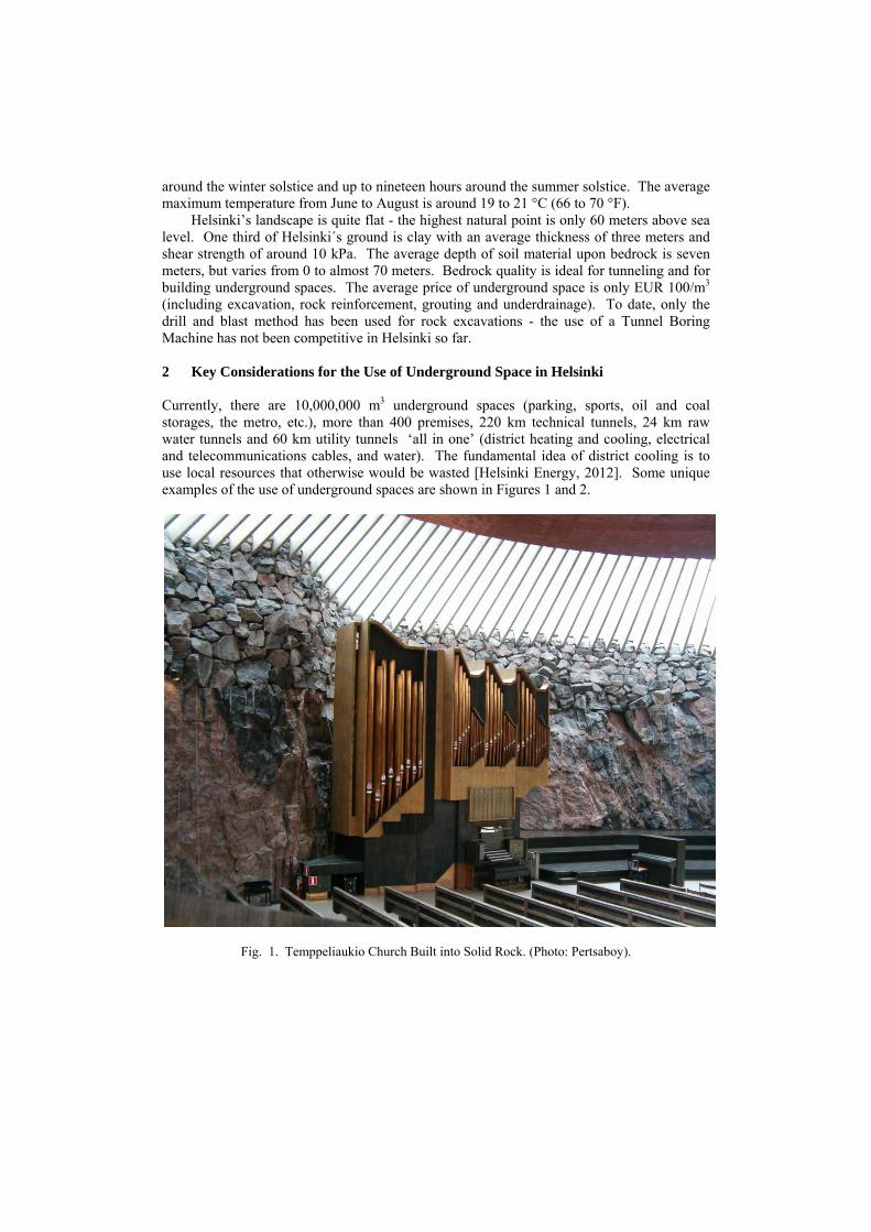
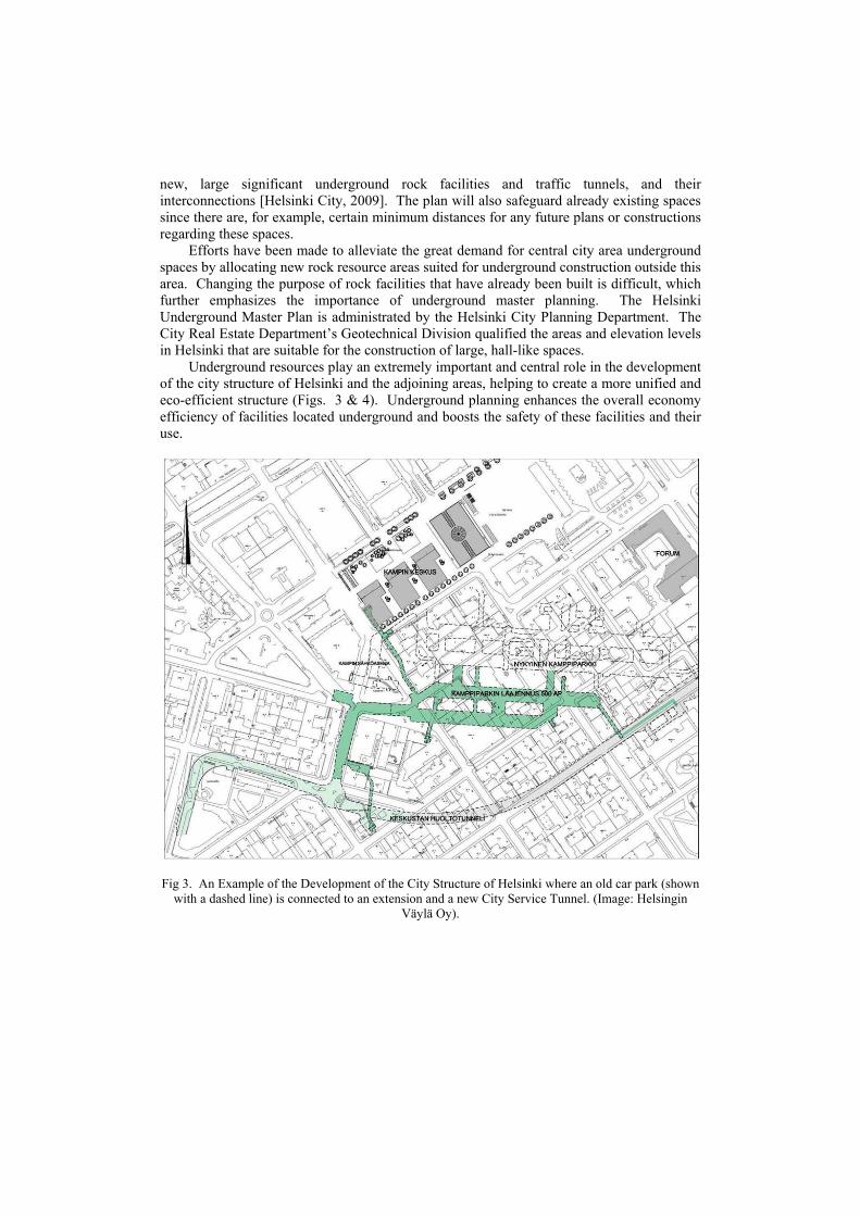
Underground resources play an extremely important and central role in the development of the city structure of Helsinki and the adjoining areas, helping to create a more unified and eco-efficient structure (Figs. 3 & 4). Underground planning enhances the overall economy efficiency of facilities located underground and boosts the safety of these facilities and their use.
Fig 3. An Example of the Development of the City Structure of Helsinki where an old car park (shown
with a dashed line) is connected to an extension and a new City Service Tunnel. (Image: Helsingin Väylä Oy).
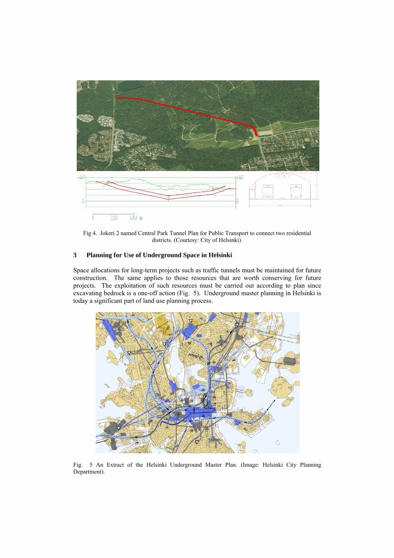
Fig 4. Jokeri 2 named Central Park Tunnel Plan for Public Transport to connect two residential districts. (Courtesy: City of Helsinki).
3 Planning for Use of Underground Space in Helsinki Space allocations for long-term projects such as traffic tunnels must be maintained for future construction. The same applies to those resources that are worth conserving for future projects. The exploitation of such resources must be carried out according to plan since excavating bedrock is a one-off action (Fig. 5). Underground master planning in Helsinki is today a significant part of land use planning process.
Fig. 5 An Extract of the Helsinki Underground Master Plan. (Image: Helsinki City Planning Department).
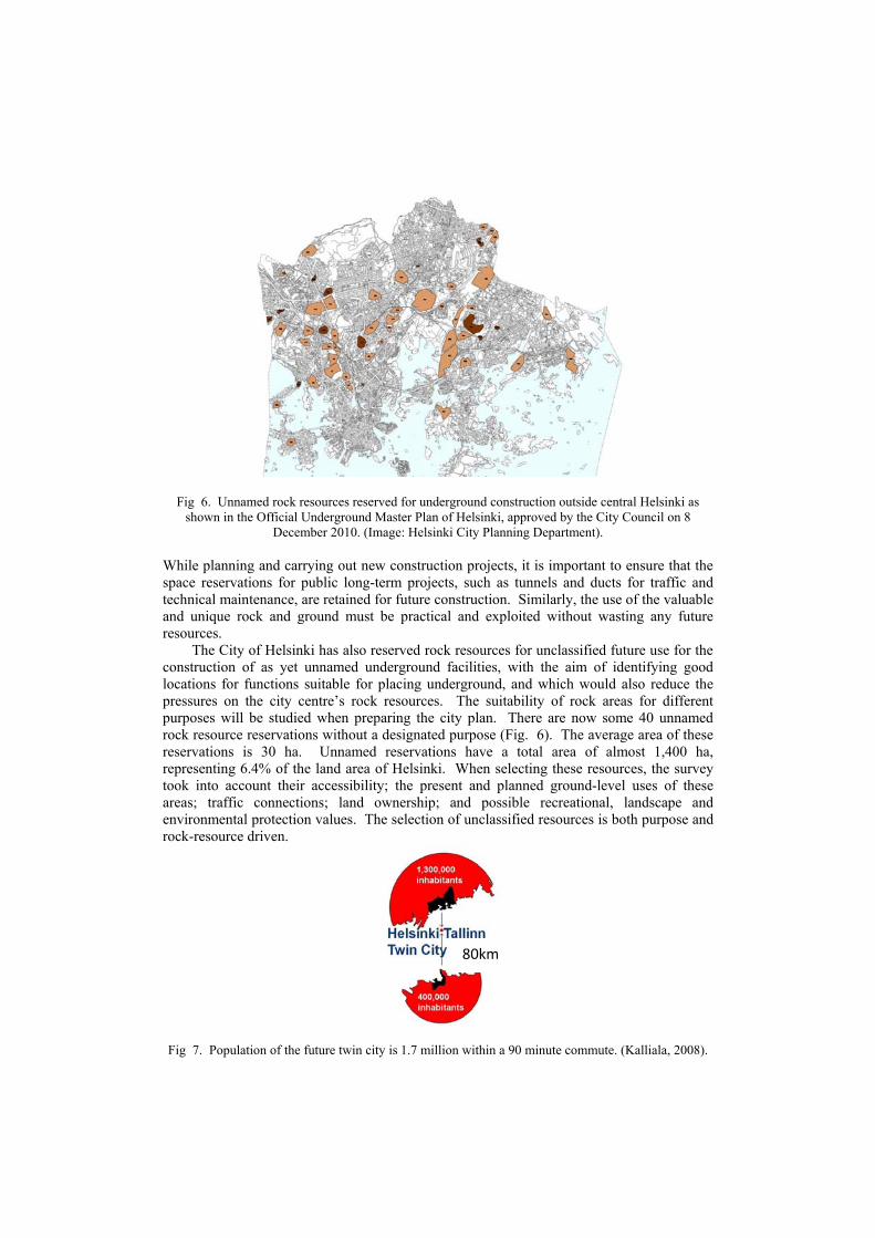
Fig 6. Unnamed rock resources reserved for underground construction outside central Helsinki as shown in the Official Underground Master Plan of Helsinki, approved by the City Council on 8
December 2010. (Image: Helsinki City Planning Department). While planning and carrying out new construction projects, it is important to ensure that the space reservations for public long-term projects, such as tunnels and ducts for traffic and technical maintenance, are retained for future construction. Similarly, the use of the valuable and unique rock and ground must be practical and exploited without wasting any future resources.
The City of Helsinki has also reserved rock resources for unclassified future use for the construction of as yet unnamed underground facilities, with the aim of identifying good locations for functions suitable for placing underground, and which would also reduce the pressures on the city centre’s rock resources. The suitability of rock areas for different purposes will be studied when preparing the city plan. There are now some 40 unnamed rock resource reservations without a designated purpose (Fig. 6). The average area of these reservations is 30 ha. Unnamed reservations have a total area of almost 1,400 ha, representing 6.4% of the land area of Helsinki. When selecting these resources, the survey took into account their accessibility; the present and planned ground-level uses of these areas; traffic connections; land ownership; and possible recreational, landscape and environmental protection values. The selection of unclassified resources is both purpose and rock-resource driven.
Fig 7. Population of the future twin city is 1.7 million within a 90 minute commute. (Kalliala, 2008).
80km

‘Greater Helsinki Vision 2050’ was the name of an International Ideas Competition (www.greaterhelsinkivision.fi/). The winner of the competition also proposed a new, fixed connection between Helsinki and Tallinn by an 80-kilometer subsea tunnel, which would generate huge potential for the capitals of Finland and Estonia to become a real twin city Helsinki-Tallinn (www.euregio-heltal.org/). According to the Twin-City Scenario (www.euregio-heltal.org/httransplan/questionnaire/scenario-2-twin-city/), “By 2030, the twin city will be formed as a closely integrated joint labor area”. The differences in the quality of social services in Helsinki and Tallinn will diminish significantly. ‘Talsinki’ (the new name of the twin city) will become a considerable development centre in northern Europe capable of competing with Stockholm and Copenhagen. Talsinki will stand as a candidate for organizing the next Olympic Games. The construction of the tunnel between the capitals will seem as a logical step for further integration of city space and the surrounding regions. Kalliala (2008) made his master’s thesis on a 21st Century Pragmatic Utopia, in which he envisages future living in the northern metropolitan twin city (Fig. 7).
Vanjoki (2012), an individual multi-contributor and former member of Nokia Group’s Executive Board, suggests that if the Guggenheim museum comes to Helsinki it will have to be built underground. Would the solution presented in Fig. 8 then be a model for the disputed museum venture? The State of Finland will, in turn, participate in the architectural competition of the venture should the museum be build of wood - an interesting challenge. Furthermore, the general opinion has to be favorable for the new museum.
Fig. 8. Underground vision from Mexico City - an ‘Earth-Scraper’ - in the case where space is needed
yet heritage does not allow skyscrapers. (Mail Online News, 2011).

4 Geotechnical Engineering for Underground Space Development in Helsinki An initial survey examined the areas and elevation levels in Helsinki which are suitable for the construction of large, hall-like spaces. A model based on rock surface data was used applying a standard-sized measurement cave (width 50 m, length 150 m, height 12 m). The model of the bedrock is based on base map data for exposed rock and land surface elevations; point data were obtained using drill machine borings (Fig. 9). The survey also took into account local weakness zones and rock resources that have already been put to use.
In general, it can be said that the bedrock in Helsinki is not far below the ground surface, and that there are plenty of reasonable and safe locations suitable for the construction of underground facilities. Outside the city centre, the survey found 55 rock areas that are sufficient in size to accommodate large underground facilities near major traffic arteries. In many areas, future underground projects can make use of entrances to existing underground facilities, which have been marked with triangles on the Master Plan map. It is worth mentioning that thermal energy from bedrock is also a noticeable resource.
Underground facilities for municipal and other technical services (such as energy, water supply and telecommunications) are, by nature, large-scale closed networks. These facilities comprise a number of different functions together with the utility tunnels connecting them. Utility tunnels are located at such a depth that space reservations for them do not have a significant effect on other underground facilities (Figs. 10 & 11).
The City of Helsinki has more than 200 km of technical maintenance tunnels, 60 km of which are utility tunnels used by a number of operators. Utility tunnels have been built since 1977 and house transmission lines and pipes for district heating, district cooling, electricity and water supply systems, as well as a large number of different cable links.
Fig. 9. An Extract of the Rock Surface Model. (Image: City of Helsinki Real Estate Department).
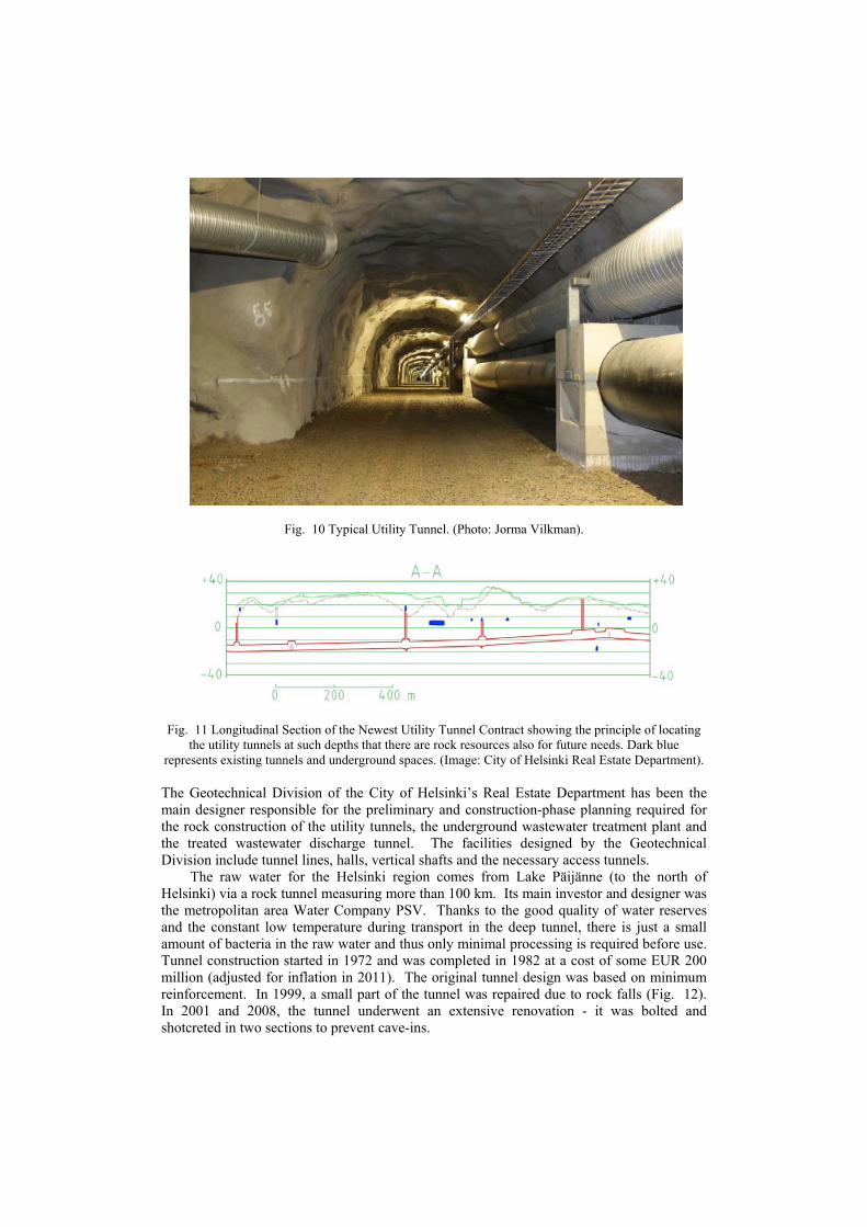
Fig. 10 Typical Utility Tunnel. (Photo: Jorma Vilkman).
Fig. 11 Longitudinal Section of the Newest Utility Tunnel Contract showing the principle of locating
the utility tunnels at such depths that there are rock resources also for future needs. Dark blue represents existing tunnels and underground spaces. (Image: City of Helsinki Real Estate Department). The Geotechnical Division of the City of Helsinki’s Real Estate Department has been the main designer responsible for the preliminary and construction-phase planning required for the rock construction of the utility tunnels, the underground wastewater treatment plant and the treated wastewater discharge tunnel. The facilities designed by the Geotechnical Division include tunnel lines, halls, vertical shafts and the necessary access tunnels.
The raw water for the Helsinki region comes from Lake Päijänne (to the north of Helsinki) via a rock tunnel measuring more than 100 km. Its main investor and designer was the metropolitan area Water Company PSV. Thanks to the good quality of water reserves and the constant low temperature during transport in the deep tunnel, there is just a small amount of bacteria in the raw water and thus only minimal processing is required before use. Tunnel construction started in 1972 and was completed in 1982 at a cost of some EUR 200 million (adjusted for inflation in 2011). The original tunnel design was based on minimum reinforcement. In 1999, a small part of the tunnel was repaired due to rock falls (Fig. 12). In 2001 and 2008, the tunnel underwent an extensive renovation - it was bolted and shotcreted in two sections to prevent cave-ins.

Fig 12. Tunnel from Lake Päijänne was repaired for the first time in 1999. (Photo: Photo Mannelin).
Wastewater treatment is carried out centrally at the Viikinmäki underground wastewater treatment plant (Figs. 13 & 14). The wastewater arrives at the plant via an extensive tunnel network. The treated wastewater is then discharged into the sea via a rock tunnel whose discharge outlet is some eight kilometers off the coast. The tunnels in the treatment plant have a capacity of more than 1,000,000 m3.
Fig. 13 An aerial view of the Viikinmäki wastewater treatment plant. (Image: City of Helsinki Real Estate Department).

Fig 14. Longitudinal section of the Viikinmäki wastewater treatment plant. (Image: City of Helsinki Real Estate Department).
The Viikinmäki wastewater treatment plant is the central plant for treating wastewater from six towns and cities. It is less than 10 km from the centre of Helsinki. The plant treats 280,000 m3 of wastewater from about 750,000 inhabitants daily. Completed at a cost of approximately EUR 180 million, the plant began operating in 1994. It replaced more than 10 smaller treatment plants, all above ground, thus allowing these sites to be zoned for more valuable uses. The construction of the underground plant took place simultaneously with the construction of ground-level infrastructures and residential buildings. The Viikinmäki residential area with 3,500 inhabitants is above the tunnels. There are also plenty of zoned ground-level areas for future residential blocks and the possible expansion of the underground wastewater treatment plant in the same Viikimäki hill area.
Technical services and utility tunnels in Helsinki are reliable and optimized large-scale networks in bedrock which have several advantages, such as:
• there is a reliable energy supply via the network with multiple links (allowing alternative routes as necessary);
• the optimization of energy generation with major transmission networks, i.e. power needs, is met by generating energy using the cheapest source at any one time;
• costs are shared between several users; • land is released for other construction purposes; • the city’s appearance and image are improved as the number of overhead lines can
be reduced; • construction work carried out on underground pipes and lines has significantly
fewer disadvantages than similar work carried out at the street level; • blast stones resulting from the construction of the tunnels can be utilized; • pipes and lines in tunnels require less maintenance - they are easier to maintain than
pipes and lines buried under streets, and the tunnel routes are shorter than those of conventional solutions;
• any breakages in pipes, lines and cables do not pose a great danger to the public; and
• tunnels are a safer option against vandalism.
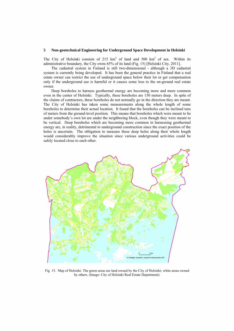
5 Non-geotechnical Engineering for Underground Space Development in Helsinki The City of Helsinki consists of 215 km2 of land and 500 km2 of sea. Within its administrative boundary, the City owns 65% of its land (Fig. 15) [Helsinki City, 2011].
The cadastral system in Finland is still two-dimensional - although a 3D cadastral system is currently being developed. It has been the general practice in Finland that a real estate owner can restrict the use of underground space below their lot or get compensation only if the underground use is harmful or it causes some loss to the on-ground real estate owner.
Deep boreholes to harness geothermal energy are becoming more and more common even in the center of Helsinki. Typically, these boreholes are 150 meters deep. In spite of the claims of contractors, these boreholes do not normally go in the direction they are meant. The City of Helsinki has taken some measurements along the whole length of some boreholes to determine their actual location. It found that the boreholes can be inclined tens of meters from the ground-level position. This means that boreholes which were meant to be under somebody’s own lot are under the neighboring block, even though they were meant to be vertical. Deep boreholes which are becoming more common in harnessing geothermal energy are, in reality, detrimental to underground construction since the exact position of the holes is uncertain. The obligation to measure these deep holes along their whole length would considerably improve the situation since various underground activities could be safely located close to each other.
Fig 15. Map of Helsinki. The green areas are land owned by the City of Helsinki; white areas owned
by others. (Image: City of Helsinki Real Estate Department).
6 Further Information Further information and international examples of the use of underground is given by the International Tunnelling and Underground Space Association at: http://www.ita-aites.org/index.php?id=102.
Detailed and accurate online geographic information about the Helsinki City region by various maps, aerial photography, plans and real estate data can be found at: http://ptp.hel.fi/index_en.html.
Technical services and large-scale utility tunnel networks in bedrock are described in more detail at: www.geotechnics.fi > CaseBank.
The Finnish Geotechnical Society SGY maintains the website www.sgy.fi/ for professionals who actively participate in ground engineering. News in English about the Helsinki – Tallinn Rail Tunnel can be found at: www.getunderground.fi/web/page.aspx?refid=62.
Finnish experts belong to the highest international level in the field of hard rock engineering. The Finnish Tunnelling Association MTR-FTA is a trailblazer that represents Finland in the International Tunnelling and Underground Space Association (ITA). The website for MTR-FTA in English is at: http://www.getunderground.fi/web/page.aspx?refid=113. 7 Conclusion The Underground Master Plan for Helsinki shows both existing and future underground spaces and tunnels, as well as existing vital access links to the underground. It also includes rock resources reserved for the construction of as yet unnamed underground facilities, with the aim of identifying good locations for functions suitable for locating underground, and which would also reduce the pressures on the city centre’s rock resources. The suitability of rock areas for different purposes will be studied when preparing the city plan. Thanks to the systematic planning process and good experiences among its citizens, underground developing has not led to a depreciation of the property on the ground. An initial survey examined the areas and elevation levels in Helsinki which are suited for the construction of large, hall-like facilities. A model based on rock surface data was used applying a standard-sized measurement cave. The model of the bedrock is based on base map data for exposed rock and land surface elevations; point data were obtained using drill machine borings. The survey also took into account local weakness zones and rock resources that have already been put to use. In general, it can be said that the bedrock in Helsinki is not far below the ground surface, and that there are plenty of locations suitable for the construction of underground facilities. Outside the city centre, the survey found 55 rock areas that are of sufficient size to accommodate large underground spaces near major traffic arteries. In many areas, future underground projects can make use of entrances to existing underground tunnels. When selecting underground resources, the survey also took into account their accessibility; the present and planned ground-level uses of these areas; traffic connections; land ownership; and possible recreational, landscape and environmental protection values.
The means of land acquisition in Helsinki is briefly the following: the primary goal of the City is to acquire the (greenfield) land needed for zoning by voluntary transactions (purchases or land switches) before the zoning begins. Thus, the value increase of the zoning is fully usable for the implementation of the town plan, i.e. building streets, parks, communal service properties such as schools and playgrounds, etc. Owning the land also gives the City the power to decide on the implementation timetable (without having to negotiate with land owners). Finnish legislation allows the City to expropriate the land if voluntary negotiations fail; however, Helsinki has been reluctant to use this option. Especially when rezoning private land, the city also negotiates ‘zoning agreements’ with the land owners involved.
These agreements stipulate how much of the public rezoning implementation costs are to be paid by the land owner. The payment is linked to the land value increase generated by the new town plan (additional and/or more valuable building rights). The land owner pays his/her share in form of land and/or money. The payment is due within a few months after the town plan has been approved and is valid.
There are several benefits of locating technical networks in bedrock: there is a reliable energy supply via a network with multiple links (allowing alternative routes as necessary); the optimization of energy generation with major transmission networks, i.e. power needs, are met by generating energy using the cheapest source at any one time; expenses are shared by several users; land is released for other construction purposes; the city’s appearance and image are improved as the number of overhead lines can be reduced; construction work carried out on underground pipes and lines has significantly fewer disadvantages than similar work carried out at street level; blast stones and also construction aggregates (sand, gravel, crushed stones) resulting from excavating the tunnels can be utilized; pipes and lines in tunnels require less maintenance - they are easier to maintain than pipes and lines buried under streets; tunnel routes are shorter than those of conventional solutions; any breakages in pipes, lines and cables do not pose a great danger to the public; and tunnels are a safer option against vandalism.
The author envisages two needs in Finland to ensure the economic long-term use of underground space. The first is a well prepared 3D cadastral system that would help administer the use of separate underground spaces at different levels, and would also enable investors to obtain loans for their underground real estates. The other is a demand to measure every single hole that is made in bedrock along its whole length. This would allow the various actors and underground spaces to exist safely together without placing too big tolerances on each other. References Hanamura T., 2011, East Japan Earthquake and Tsunami and Underground Structures, Oral
Presentation, Open Session in World Tunnel Congress 2011, 24 May 2011, Helsinki. Helsinki City, 2009, The Helsinki Underground Master Plan, Brochure, Helsinki City Planning
Department, www.hel2.fi/ksv/julkaisut/esitteet/esite_2009-8_en.pdf Helsinki City, 2011, Annual Report 2010 of the Helsinki City Real Estate Department (in Finnish and
in Swedish). Helsinki Energy, 2012, Production of District Cooling, www.helen.fi/energy/kj_tuotanto.html Kalliala M., 2008, Talsinki Island, A 21st Century Pragmatic Utopia, Master´s Thesis in Architecture,
Helsinki University of Technology. Mail Online News, 2011, Introducing the earth-scraper, 12 October, www.dailymail.co.uk/news/article-
2048395/Earth-scraper-Architects-design-65-storey-building-300-metres-ground.html Vähäaho I., 2011a Keynote lecture (Helsinki Experience with Master Planning for Use of Underground
Space), Proceedings of the Joint HKIE-HKIP Conference on Planning and Development of Underground Space, The Hong Kong Institution of Engineers & The Hong Kong Institute of Planners, 23-24 September 2011, Hong Kong, pp. 1-9
Vähäaho I., 2011b, Workshop on “Use of Underground Space in Hong Kong” for the Hong Kong Government’s engineers and city planners, 26 September 2011, Hong Kong
Vanjoki A., 2012, STT-Lehtikuva (Finland's leading news- and picture agency), News in Finnish 29
April 2012, www.hs.fi/kotimaa/Vanjoki+louhisi+Guggenheimin+maan+alle/a1305558837220