Թեզիսների Խմբագիրներ Մարկուս Ֆիեբիգ · the site contains Middle...
59
Transcript of Թեզիսների Խմբագիրներ Մարկուս Ֆիեբիգ · the site contains Middle...


2
Ծրագիր և Թեզիսների ժողովածու
Խմբագիրներ
Մարկուս Ֆիեբիգ
Խաչատուր Մելիքսեթյան
Բորիս Գասպարյան
Դմիտրի Առաքելյան

3
NATIONAL ACADEMY OF SCIENCES OF THE REPUBLIC OF ARMENIA
IGS - INSTITUTE OF GEOLOGICAL SCIENCES
IAE - INSTITUTE OF ARCHAEOLOGY AND ETHNOGRAPHY
INQUA - SACCOM COMMISSION ON STRATIGRAPHY AND CHRONOLOGY
INQUA - ASQUA ASIAN QUATERNARY STRATIGRAPHY
INQUA – SEQS SECTION ON EUROPEAN QUATERNARY STRATIGRAPHY
WORKSHOP 3 – 10 SEPTEMBER 2016, ARMENIA
Bridging Europe and Asia: Quaternary stratigraphy and Paleolithic human occupation
in Armenia and Southern Georgia
Program and Abstracts Volume
Editors
Markus Fiebig
Khachatur Meliksetian
Boris Gasparyan
Dmitri Arakelyan
Yerevan, Armenia – 2016

4
EXCURSION PROGRAM
4th of September, 9.00 Yerevan-Alaverdi- Sanahin-Haghpat- Alaverdi (Neghots)
(accommodation in hotels in Alaverdi and at the base camp of IGS near Neghots)
(Responsible person: Dr. Kh. Meliksetian, IGS)
Fig 1. Route map of 4th
of September field
trip
Fig. 2. Aragats stratovolcano, 4090 m. a.s.l. last central
vent and flank activity ~500 Ka
Fig 3. 10th
century AD Armenian monastic
complex in Haghpat, Lori province, Armenia.
Fig. 4. 230 m high cliff ~ 3 km ENE of
Alaverdi, showing a sequence of columnar-
tiered pahoehoe sheet flows.

5
1. Aragats stratovolcano. Short stop at the foothills of Quaternary Aragats volcano. Aragats
(4090m) is one the largest volcanoes in the entire region of post collisional volcanism. It has
produced big number of central vent (inc. Plinian VEI>4) and monogenetic type flank eruptions. The
youngest activity of Aragats is dated to ~500 Ka.
2. Visits to historical sites in Lori region of Armenia, around Alaverdi. Cathedrals and
monasteries planned to visit are located on the plateaus along the valley with a picturesque
landscape formed by the Debed River, which cross cuts major Early Pleistocene Plateau basalts and
provides nice overview of the regional geology of the area.
a. Sanahin. Armenian monastery of 10th century, UNESCO World Heritage Site, is famous by
unique architectural forms and a number of khachkars (cross-stones).
b. Haghpat is a 10th century Armenian monastic complex in Haghpat, Armenia, another
UNESCO World Heritage Site.
3. Plateau basalts in Canyon of Debed River. Late Pliocene-Early Pleistocene plateau basalts
outcrops are located near Alaverdi. These fissure-fed, rapidly erupted fluid lavas filled pre-existing
river valleys over tens of kilometers in the South Caucasus region, including the Kars–Erzurum Plateau
(northeastern Turkey), the Javakheti Plateau (Georgia–Armenia), and the Lori Plateau (northern
Armenia). Because its main geological features are remarkably like those of many continental flood
basalt (CFB) provinces, it is considered as true, albeit small, CFB province, regardless of the tectonic
setting (continental collision). It is the smallest and youngest CFB in the world (Sheth et al., 2015).
Many regional Paleolithic sites are found on the top of plateau basalts, Karakach, Dmanisi, Kurtan,
Bagratashen-1.

6
5th of September, Alaverdi (Neghots) – Haghtanak-3 – Dmanisi (Georgia) – Alaverdi (Neghots)
(Responsible persons: B. Gasparyan, IAE NAS, Armenia, Prof. D. Lordkipanidze, Georgian National
Museum).
Fig. 5. Route map of 5th
of September field trip
Fig 6. Hakhtanak-3 open air site longitudal section
1. Haghtanak-3. Hagtanak-3 is a multiperiod open-air archaeological site, which contains
Iron-Age cemetery, Chalcolithic settlement and Paleolithic habitation phases from Upper to Lower.
The most significant ones are the finds of the pebble tools in the lowermost strata, which may signify
hominid presence in the Debed river valley during the early Pleistocene. (Egeland et al. 2011).

7
2. Dmanisi. Dmanisi in South Georgia is an early hominine site, fossils are dating back at 1.8
million years and are now believed to be a subspecies of Homo erectus. (Lordkipanidze et al. 2013).
Fig 7. The Lower Paleolithic site of Dmanisi is situated beneath the ruins of the medieval town of
Dmanisi (source of photos: www.dmanisi.ge)
6th of September, Alaverdi (Neghots) – Odzun-Kurtan-Karakhach – Alaverdi (Neghots)
(Responsible person: Dr. Trifonov, Geological Institute RAS, Russian Federation, E. Belyaeva, Institute
for the History of Material Culture, RAS, Russian Federation)
Fig 8. Route map of 6th
of September field trip.
8
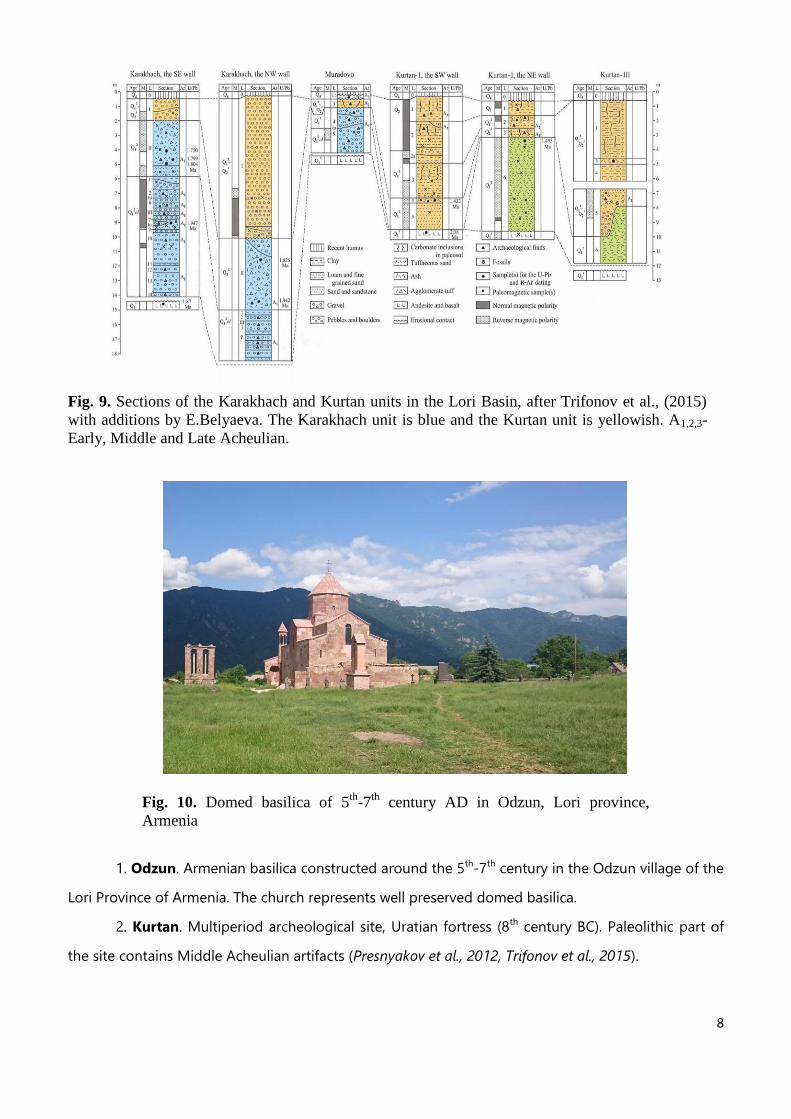
Fig. 9. Sections of the Karakhach and Kurtan units in the Lori Basin, after Trifonov et al., (2015)
with additions by E.Belyaeva. The Karakhach unit is blue and the Kurtan unit is yellowish. A1,2,3-
Early, Middle and Late Acheulian.
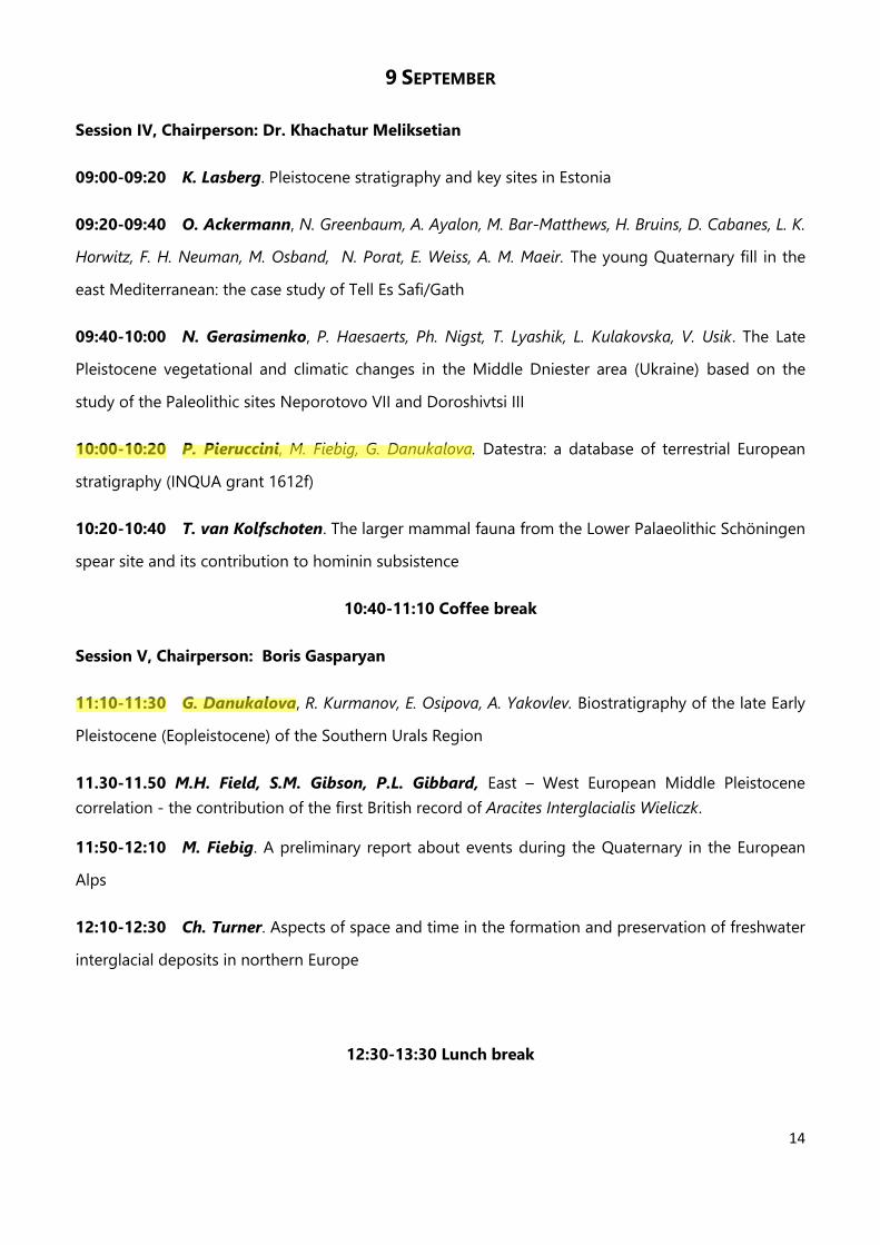
Fig. 10. Domed basilica of 5th
-7th
century AD in Odzun, Lori province,
Armenia
1. Odzun. Armenian basilica constructed around the 5th-7th century in the Odzun village of the
Lori Province of Armenia. The church represents well preserved domed basilica.
2. Kurtan. Multiperiod archeological site, Uratian fortress (8th century BC). Paleolithic part of
the site contains Middle Acheulian artifacts (Presnyakov et al., 2012, Trifonov et al., 2015).

9
3. Karakhach. Early Paleolithic site. The course-grained pyroclastic unit of Karakhach was
deposited during the Olduvai subchron (not earlier than 1.9-1.85 Ma) and the earliest Calabrian. The
region was occupied by the earliest hominines producing lithic industries of the Early Acheulian
aspect. (Presnyakov et al., 2012, Trifonov et al., 2015)
7th of September, Alaverdi (Neghots) – Sevkar-Sevan-Nor Geghi-1 – Yerevan
(accommodation in a hotel)
(Responsible persons: Dr. A. Karakhanyan, Dr. L. Sahakyan, IGS NAS Armenia, D.S.Adler, University of
Connecticut, USA)
Fig. 11. Route map of 7th
of September
field trip
Fig 12. Lake Sevan with volcanoes of Gegham
highland in the background (upper picture).
Sevanаvank monastery (9th
century AD) on
Sevan peninsula (lower picture)
1. Sevkar. Well dated stratigraphic succession of unaltered loess deposits, paleosols, colluvial
slope deposits, and volcanic ashes. The chronology of formation of loess-paleosol sequences with
volcanic ash corresponds to Late-Pleistocene-Holocene. (Wolf et al., 2016).

10
2. Lake Sevan and Sevanavank monastery. Sevan Lake is the largest lake in Armenia and the
entire Caucasus Region. It is one of the largest freshwater high-altitude lakes in the world. Altitude of
the lake is 1900 m. The geology of the lake and its surroundings represent an interesting combination
of Quaternary and Holocene tectonics and volcanism. Sevanavank is a 9th century monastic complex
located on a peninsula at the northwestern shore of Lake Sevan.
3. Nor Geghi-1. Paleolithic site that marks the Lower to Middle Paleolithic transition
(~400,000 to 200,000 years BC). The site contains dated sections of lava flows, volcanic ash and
paleosols with tools (Adler et al., 2014).
Fig. 12 . A: Cross-section of a loess ridge belonging to the BL-profile section (The BL-profile is
situated 2.5 km from the Sevkar profile in a northern direction.). B: Representative image of the
loess-influenced landscape nearby Sevkar village. Note the dispersed outcrops of volcanic rocks and
the blackish soils that have developed within loess covering the depth contours. C: Photo of the
Sevkar profile section on a road-embankment with layers inclined towards NE (right side). (after
Wolf et al., 2016).
Fig. 13. Representative stratigraphic section at Nor Geghi-1 site

11
CONFERENCE PROGRAM
8-9 SEPTEMBER, ROUND HALL OF PRESIDIUM OF THE NATIONAL ACADEMY OF SCIENCES
OF REPUBLIC OF ARMENIA
8 SEPTEMBER
09:00-09:20 Introduction and Welcome address by
Director of IGS, Dr. Sci. Arkady Karakhanyan
Director of IAE Dr. Sci. Pavel Avetissyan
President of SEQS Prof. Dr. Markus Fiebig
Session I, Chairperson: Prof. Markus Fiebig
09:20-09:40 V. Trifonov, H. Ҫelik, D.V. Ozherelyev, A.N. Simakova, D.M. Bachmanov, Ya. Trikhunkov,
P. Frolov, A. Tesakov. The Pliocene-Quaternary evolution of the Euphrates valley in the northern
surrounding of the Arabian Plate
09:40-10:00 D. Wolf, Ch. Richter, R. Zech, Y. Trigui, L. Sahakyan, Kh. Meliksetian, Ph. Baumgart, A.
Fülling, D. Faust. Middle and Upper Pleistocene environmental conditions in NE Armenia based on
bio-proxy records from loess strata
10:00-10:20 E. Belyaeva. The Acheulian industrial sequence in the early-middle Pleistocene
volcanogenic deposits of NW Armenia
10:20-10:40 E. Shalaeva, V. Trifonov, V. Lebedev, A. Avagyan, L. Sahakyan, A. Simakova, A.
Kolesnichenko, P. Frolov, A. Tesakov, D. Arakelyan, D. Bachmanov, E. Belyaeva, V. Lyubin. Quaternary
geology and origin of the Shirak basin, NW Armenia
10:40-11:00 B. Gasparian, S. Nahapetyan, V. Ollivier, D. Arakelyan, A. Petrosyan. Landscape
dynamics and Paleolithic occupation in Aparan Depression (Armenia)
11:00-11:30 Coffee break

12
Session II, Chairperson Dr. Sci. Vladimir Trifonov
11:30-11:50 A. Malinsky-Buller, Ph.J. Glauberman, E.J. Beverly, J. Sherriff, K.N. Wilkinson, E. Frahm,
S. Nahapetyan, S. Karapetyan, B. Gasparian, D.S. Adler. Alapars 1 - a new Middle/Upper Pleistocene
paleoenvironmental and prehistoric record from the Hrazdan-Kotayk Plateau
11:50-12:10 Ch.P. Egeland, B. Gasparian, C. Fadem, D. Arakelyan, S. Nahapetyan. The geological
context of Paleolithic occupations along the Debed River valley of northeastern Armenia
12:10-12:30 A.A. Bruch, I. Gabrielyan, I. Shatilova. The Dmanisi landscape – paleobotanical
evidences for the reconstruction of early human environments in the Southern Caucasus
12:30-12:50 D.S. Adler. K.N. Wilkinson, S. Blockley, E. Frahm, D. Mark, C. Mallol, S. Nahapetyan, E.
Beverly, B. Gasparyan. Nor Geghi 1: Its Middle Pleistocene geological context and relevance to
Palaeolithic archaeology in the Southern Caucasus
13:00-14:00 Lunch break
14:00-15:30 POSTER SESSION, Chairperson Dr. Sci. Guzel Danukalova
A.K. Otcherednoy, L.B. Vishnyatsky, N.E. Zaretskaya, E.V. Voskresenskaya, K.N. Stepanova, A.V.
Larionova, P.E. Nekhoroshev. Stratigraphy And Radiocarbon Chronology Of Three Late Middle
Paleolithic Sites In The Russian Plain
A. Simakova. Palynological characteristics of the Ani formation in the Shirak basin, NW Armenia
A. Nadachowski, G. Lipecki, M. Baca, J. Wilczyński. Impact of climate and humans on range dynamics
of woolly mammoth (Mammuthus primigenius) in Europe during MIS 2
L. Popova, I. Zagorodniuk. Ranges of ground squirrel species and geographical barriers in the
Pleistocene of the Circum-Black Sea area
V. Astakhov. The glaciated Urals: barrier or bridge?
S. Parfitt, T. King, L. Yepiskoposyan, J.Murray and L. Asryan. Pleistocene Environments and Early
Humans in the Lesser Caucasus: New Small Mammal Data from Azokh Cave.
Ph. Glauberman, B. Gasparyan, K.N. Wilkinson, E. Frahm, S. Nahapetyan, D. Arakelyan, Y. Raczynski-
Henk, H. Haydosyan, D.S. Adler. Barozh 12: Stratified Middle Palaeolithic occupations in an upper
Pleistocene flood plain setting at the edge of the Ararat Depression, Armenia
15:30-16:00 Coffee break

13
Session III, Chairpesron։ Dr. Pierluigi Pieruccini
16:00-16:20 O. Korsakova, Ya. Yelovicheva, A. Molodkov, V. Kolka. Middle Pleistocene marine
deposits on the Kola Peninsula (NW Russia)
16:20-16:40 J.P. Lefort, G. Danukalova, F.Eynaud, J.L. Monnier. Onshore and offshore evidences for
four abrupt warming episodes during MIS 6 at the westernmost tip of continental Europe: their
astronomical origin
16:40-17:00 N. Zaretskaya. The MIS3 in the European northeast: chronology and events
17.00 – 18.00 SEQS Business meeting
20:00 Conference dinner in Yerevan city
Guzel
Выделение
14
9 SEPTEMBER
Session IV, Chairperson: Dr. Khachatur Meliksetian
09:00-09:20 K. Lasberg. Pleistocene stratigraphy and key sites in Estonia
09:20-09:40 O. Ackermann, N. Greenbaum, A. Ayalon, M. Bar-Matthews, H. Bruins, D. Cabanes, L. K.
Horwitz, F. H. Neuman, M. Osband, N. Porat, E. Weiss, A. M. Maeir. The young Quaternary fill in the
east Mediterranean: the case study of Tell Es Safi/Gath
09:40-10:00 N. Gerasimenko, P. Haesaerts, Ph. Nigst, T. Lyashik, L. Kulakovska, V. Usik. The Late
Pleistocene vegetational and climatic changes in the Middle Dniester area (Ukraine) based on the
study of the Paleolithic sites Neporotovo VII and Doroshivtsi III
10:00-10:20 P. Pieruccini, M. Fiebig, G. Danukalova. Datestra: a database of terrestrial European
stratigraphy (INQUA grant 1612f)
10:20-10:40 T. van Kolfschoten. The larger mammal fauna from the Lower Palaeolithic Schöningen
spear site and its contribution to hominin subsistence
10:40-11:10 Coffee break
Session V, Chairperson: Boris Gasparyan
11:10-11:30 G. Danukalova, R. Kurmanov, E. Osipova, A. Yakovlev. Biostratigraphy of the late Early
Pleistocene (Eopleistocene) of the Southern Urals Region
11.30-11.50 M.H. Field, S.M. Gibson, P.L. Gibbard, East – West European Middle Pleistocene
correlation - the contribution of the first British record of Aracites Interglacialis Wieliczk.
11:50-12:10 M. Fiebig. A preliminary report about events during the Quaternary in the European
Alps
12:10-12:30 Ch. Turner. Aspects of space and time in the formation and preservation of freshwater
interglacial deposits in northern Europe
12:30-13:30 Lunch break
Guzel
Выделение
Guzel
Выделение

15
Session VI, Chairperson: Prof. Charles Turner
13:30-13:50 T. Gaudenyi. Stratigraphical units of the Pleistocene temperate stage fluvial deposits
of Serbia
13:50-14:10 A. Zastrozhnov, G. Danukalova, S. Semiletkin. Quaternary key-sites and horizon
stratotypes of the European part of Russia: basic principles of an electronic database
14:10-14:30 M. Coltorti. Radiometric dating in continental areas: uncertainties emerging from an
integrated approach
14.30-15.00 Coffee Break
Session VII, Chairperson Prof. Daniel Adler
15:00-15:20 G. Danukalova, A. Zastrozhnov. Characteristic of the Apsheronian (Early Pleistocene)
deposits of the Lower Volga area (Astrakhan arch)
15:20-15:40 T. Sahra, A. Stefano, A. Fabrizio, C. Mauro, D. Beatrice, De R. Federico, F. Manfred, G.
Fabienne, K. Pascal, L. Katrin, M. Paolo, P. Pierluigi, P. Vincenzo. Crosschecking of stratigraphic data
(crosstrat): a SEQS project to test the stratigraphic setting of continental deposits in Sardinia and the
reliability of radiometric dating
15:40-16:00 P. Pieruccini, A. Bertini, M. Coltorti, D. Magri, E. Martinetto, M. Palombo, C. Ravazzi.
Datestra, a database of terrestrial European stratigraphy (INQUA grant 1612f): the example of
selected sites from Italy
16:00-16:20 T. Sapelko, S. Kulakov. Pleistocene-Holocene pollen chronology in the Caucasus
Region
16:20-16:40 Ya. Trikhunkov, E. Zelenin, E. Novenko, A. Kolesnichenko, E. Shalaeva, P. Frolov, A.
Revunova. The Late Quaternary river terraces and archeological sites as indicator of modern tectonic
deformations of the Western Caucasus
16:40-17:40 Final discussion and concluding remarks
Guzel
Выделение
Guzel
Выделение

16
Abstracts
THE PLIOCENE-QUATERNARY EVOLUTION OF THE EUPHRATES VALLEY IN THE NORTHERN
SURROUNDING OF THE ARABIAN PLATE
V.G. Trifonov1, H. Ҫelik2, D.V. Ozherelyev3, A.N. Simakova4, D.M. Bachmanov5, Ya.I.
Trikhunkov6, P.D. Frolov7, A.S. Tesakov8
1Geological Institute, Russian Academy of Sciences (RAS), 7 Pyzhevsky, Moscow 119017, Russia, [email protected]
2 Firat University, Elazig, Turkey, [email protected]
3 Institute of archaeology, RAS, 19 Dmitriya Ul’yanova str., Moscow 117036, Russia, [email protected]
4 Geological Institute, RAS, Moscow, Russia, [email protected]
5 Geological Institute, RAS, Moscow, Russia, [email protected]
6 Geological Institute, RAS, Moscow, Russia, [email protected]
7 Geological Institute, RAS, Moscow, Russia, [email protected]
8 Geological Institute, RAS, Moscow, Russia, [email protected]
Paleogeography of the Euphrates River valley changes due to sinistral movements on the
East-Anatolian Fault Zone (EAFZ) and the Taurus Ridge rise by movements on the South Taurus
Thrust. Evidence of these changes is based on studies of the Pliocene–Quaternary deposits of the
Euphrates River basin to the north and the south of the Taurus Ridge and the Late Cenozoic
deformation. Combination of methods was used to date the Pliocene–Quaternary deposits. They were
geological and geomorphological correlation of sections, determination of remanent magnetic
polarity, paleontological and archaeological finds, palynological analysis, and K-Ar dating of volcanic
rocks. To the north of the Taurus Ridge, the Late Miocene tectonic depressions were filled by lakes
connected by migrated channels. The waters found flow at the Early Pliocene to the south via the
graben-like trough of the recent Sultan-Suyu River valley and farther to the Göksu River. The flow was
interrupted because of some desiccation and rise of the Taurus Ridge, recommenced in the end
Gelasian – early Calabrian and was interrupted again. At the end of Calabrian (~0.8–0.9 Ma), the
Euphrates waters broke via the Taurus Ridge along the recent valley and the former upstream
bottoms of the Euphrates and its tributaries became the upper terrace. After this, the Taurus Ridge
raised more than to 330 m. The lower terraces were formed because of the regional uplift. The uplift
was more intense to the north of the Taurus Ridge, than to the south of it. The new-formed Euphrates
valley was offset on the EAFZ at 12 km that gives the average slip rate 13–15 mm/year. The Early
Paleolithic stone industries were found in the Lower Pleistocene deposits. They are picks, pick-like
tools, one-sided and double-sided choppers. The oldest artefacts were found in the layers that
deposited before the Olduvai subchron, i.e., ~2 Ma. These finds mark a way of migration of the oldest
hominine from Arabia to Caucasus and possibly to the other Eurasia.

17
MIDDLE AND UPPER PLEISTOCENE ENVIRONMENTAL CONDITIONS IN NE ARMENIA BASED
ON BIO-PROXY RECORDS FROM LOESS STRATA
Daniel Wolf1, Christiane Richter2, Roland Zech3, Yesmine Trigui1, Lilit Sahakyan4, Khachatur
Meliksetian4, Philipp Baumgart1, Alexander Fülling5, Dominik Faust1
1 Institute of Geography, TU Dresden; Helmholtzstr. 10, 01062 Dresden, Germany;
2 Institute of Geology, TU Bergakademie Freiberg; Bernhard-v.-Cotta-Straße 2, 09599 Freiberg;
3 University of Bern; Hallerstrasse 12, 3012 Bern;
4 Institute of Geology, Academy of Science of Armenia; Baghramyan ave.24a, 0019 Yerevan, Armenia;
5 Institute of Geography, Humboldt-Universität zu Berlin; Unter den Linden 6, 10099 Berlin, Germany;
In NE-Armenia, loess-palaeosol sequences with a thickness of more than 20 m provide
valuable information on Middle and Upper Pleistocene climate changes. The succession of
unweathered loess deposits and paleosols corresponds well to the series of the last three glacial-
interglacial cycles, although numerical dating is still challenging regarding the high content of
volcanic material. Beside pedogenetic features and indications of erosion and relocation that allow
the reconstruction of landscape dynamics, different bio-proxies enable us to assess
palaeoenvironmental and palaeoclimatic conditions on a high level of detail.
In the presentation, first results of terrestrial mollusc analyses shall be discussed, together with
information from lipid biomarkers and black carbon of vegetation fire residues. In the first instance,
different proxies seem to indicate divergent environmental conditions for specific periods. To pursue
these discrepancies will be a major part of future research.
Since the project is still in an early stage, main research questions, possible solution
approaches, and methodological difficulties will be discussed.

18
THE ACHEULIAN INDUSTRIAL SEQUENCE
IN THE EARLY-MIDDLE PLEISTOCENE VOLCANOGENIC DEPOSITS OF NW ARMENIA
Elena V. Belyaeva
Institute for the History of Material Culture, Dvortsovaya nab. 18 St-Petersburg Russia, [email protected]
The Early Paleolithic of Armenia and the entire Caucasus is dominated by Acheulian, i.e.
industries with large-sized tools, especially handaxes (bifaces). Ten years ago, only Late Acheulian
industries (second half of the Middle Pleistocene) were known there. Acheulian sites newly discovered
in the Lori intermountain depression, NW Armenia first revealed a longer industrial sequence. The
Acheulian bearing deposits of Lori occur on the basalts flowing from Javakheti Ridge around 2.0-1.8
Myr. Like in the rest of Armenia, in Lori most typical Late Acheulian handaxes were collected in
surface localities resulted from intense erosion of the Late and partly Middle Pleistocene sediments. A
single stratified but undated assemblage is Dashtadem 3. The handaxes fashioned mainly by partial
bifacial treatment of large flakes and accompanying products of the Levallois flaking were made of
local hyalodacite. Late Acheulian sites of other parts of Armenia (Satani-Dar, Jraber, Hatis, Nor Geghi
etc.) yielded similar industries but made mostly of obsidian. The age of the regional Late Aheulian
was estimated only in Nor Geghi (Ar 40r- Ar 39 dates 350-325 Kyr). The older Acheulian of Lori was
found in the foothills of Javakheti Ridge (Muradovo, Karakhach) and the Basum Ridge (Kurtan I). In
Muradovo under redeposited layers 1-2 with the Late Acheulian analogous to that of Dashtadem 3
there is a paleosol (layer 3) with the Middle Acheulian (?) non-Levallois industry. The lower layers 4-9
are proluvial with typical Early Acheulian artifacts (crude handaxes, picks, choppers) made mainly of
slab-like pieces of rhyodacite. The hyalodacitic industry of the layer 3 is similar to that of Kurtan I
where local rhyolite and basalt were used. Paleomagnetic and faunal data of Kurtan I suggest the
interval 0.5-1.0 Myr. The oldest industry of Muradovo is similar to another Early Acheulian industry
from the proluvial unit of the Karakhach quarry. This unit with normal magnetic polarity is covered
with the 4-9 m tephra with reverse polarity and six SIMS U-Pb dates around 1.95-1.75 Myr. Hence,
the Early Acheulian industries of Karakhach and, probably, Muradovo existed in NW Armenia during
the Olduvai subchron at the same time as the Oldovan industry of the nearby Dmanisi site (Southern
Georgia).

19
QUATERNARY GEOLOGY AND ORIGIN OF THE SHIRAK BASIN, NW ARMENIA
E.A. Shalaeva1, V.G. Trifonov2, V.A. Lebedev3, A.V. Avagyan4, L.H. Sahakyan5, A.N. Simakova6,
A.A. Kolesnichenko7, P.D. Frolov8, A.S. Tesakov9, D.G. Arakelyan10, D.M. Bachmanov11, E.V.
Belyaeva12, V.P. Lyubin12
1 Geological Institute of the Russian Academy of Sciences (RAS), 7 Pyzhevsky, Moscow 119017, Russia, [email protected]
2 Geological Institute of the RAS, Moscow, Russia, [email protected]
3 Institute of Geology of Ore Deposits, Petrography, Mineralogy and Geochemistry of the RAS, 35 Staromonetny,
Moscow 119017, Russia, [email protected]
4 Institute of Geological Sciences of the National Academy of Sciences of Republic of Armenia, 24a Marshal
Baghramyan Ave., Yerevan 0019, Armenia, [email protected]
5 Institute of Geological Sciences of the National Academy of Sciences of Republic of Armenia, Yerevan, Armenia,
6 Geological Institute of the RAS, Moscow, Russia, [email protected]
7 Geological Institute of the RAS, Moscow, Russia, [email protected]
8 Geological Institute of the RAS, Moscow, Russia, [email protected]
9 Geological Institute of the RAS, Moscow, Russia, [email protected]
10
Institute of Geological Sciences of the National Academy of Sciences of Republic of Armenia, Yerevan, Armenia,
11
Geological Institute of the RAS, Moscow, Russia, [email protected]
12
Institute of History of Material Culture of the RAS, 18 Dvortsovaya Naberezhnaya, St. Petersburg 191186, Russia,
The Shirak Basin developed since the Upper Pliocene till the early Middle Pleistocene and was
drawn in total uplift of the Lesser Caucasus later. Basaltic trachiandesites poured into the southern
part of the basin in Pliocene from the Kars-Digor Highland in the west. A thick lacustrine formation
was accumulated in the more northern part of the basin in the Late Pliocene and perhaps the early
Gelasian, according to the Yu.V. Sayadyan data. In the late Gelasian (2.3–2.0 Ma), basaltic
trachiandesites penetrated into the northern Shirak Basin from the Javakheti Highland. More than
150-meter thick terrigenous deposits were accumulated in the basin in the Calabrian and early
Middle Pleistocene. They are differentiated to the Karakhach, Ani and Arapi units. The 20-meter thick
Karakhach unit consists of sand-pebble alluvium in the upper part and mostly fine-grained deposits
lower that were formed by stagnant, partly lake waters. The Ani and Arapi units represent
sedimentary cycles. Each cycle begins by lacustrine clays, silts and diatomite and finishes mainly by
alluvial sands, gravels and pebbles. The Karakhach unit covers the northern margin of the basin. The
Ani unit is incised at 50–70 m into the Karakhach unit surface to the north and has the highest
thickness (up to 150 m) in the northern part of the basin. The Arapi unit (up to 75 m) is incised at 50–
80 m into the Ani unit surface to the north and covers central and southern parts of the basin,
spreading to the south farther than the Ani unit. This demonstrates the successive uplift of the
northern Shirak Basin and migration of the lacustrine sedimentation area to the south. The unit ages
were determines by combined using of the data on remanent magnetic polarity of the deposits, finds
of stone industry of the earliest Paleolithic in the Karakhach unit, faunas of mollusks in the Ani and
Arapi units and small mammals in the Arapi unit as well as results of the spore-pollen analysis and K-
Ar dating of tuffs and lavas. The age of the Karakhach unit corresponds to the late Olduvai
paleomagnetic subchron and the early Calabrian. The Ani unit is dated to the late Calabrian and the
earliest Middle Pleistocene (~1.25–0.75 Ma) and the Arapi unit is dated to early Middle Pleistocene
(0.7+0.05 Ma). The Shirak Basin is bounded to the north by the Kaps flexure-fault zone, and to the
east by the flexure-fault zone of the Trans-Caucasus transverse uplift. The Javakheti Ridge volcanic
chain is situated in the northern continuation of the uplift and the Mets-Sharailer (Calabrian?) and
Aragats (~1–0.4 Ma) volcanoes mark its southern continuation. These zones of deformation do not
correspond to the Late Cenozoic faults caused by collision. At the same time, volcanic eruptions
occurred in the basin surroundings during whole epoch of its subsidence. Synchronism of these
processes can justify genetic links of the basin subsidence and the mantle motion and transformation
manifested by volcanism.

20
LANDSCAPE DYNAMICS AND PALEOLITHIC OCCUPATION IN APARAN DEPRESSION
(ARMENIA)
Boris Gasparian 1, Samvel Nahapetyan2, Vincent Ollivier3, Dmitri Arakelyan4, Artur Petrosyan1
1Institute of Archaeology and Ethnography, National Academy of Sciences of the Republic of Armenia, Armenia
2Faculty of Geography, Yerevan State University, Armenia
3CNRS / Collиge de France PrOCauLAC UMR 7192, Paris, France
4Institute of Geological Sciences, National Academy of Sciences of the Republic of Armenia, Armenia
Study of lacustral sediments and reconstruction of paleolake environments in Aparan
Depression in parallel with rich Paleolithic record of the area is allowing to conclude that Middle
Paleolithic hominin occupation was mainly organized around the shores of the Pleistocene lakes. It
was functioning based of combination of rich life supporting resources and obsidian raw-materials in
strong connection with volcanism, glaciations and tectonic shifts. At the beginning of Holocene,
when the lakes disappeared, local populations changed their lifeways, occupying mainly caves and
rock-shelters in the Kasakh River gorge. In parallel with hunting, fishing started to play an important
role in the economy of the Early Holocene population of the Aparan Depression.

21
ALAPARS 1 - A NEW MIDDLE/UPPER PLEISTOCENE PALEOENVIRONMENTAL AND
PREHISTORIC RECORD FROM THE HRAZDAN-KOTAYK PLATEAU
Ariel Malinsky-Buller1; Phil, J. Glauberman2; Emily J. Beverly3; Jenni Sherriff4; Keith
N.Wilkinson4; Ellery Frahm5; Samvel Nahapetyan6; Sergey Karapetyan7; Boris Gasparyan8;
Daniel, S. Adler1
1Department of Anthropology, Old World Archaeology Program, University of Connecticut, USA
2Middle East Technical University, Ankara, TR
3Georgia State University, Atlanta, Georgia, USA
4University of Winchester, UK
5University of Minnesota, Minneapolis, MN, USA
6Department of Cartography and Geomorphology, Yerevan State University, Armenia.
7Institute of Geological Sciences, National Academy of Sciences, Armenia
8Institute of Archaeology and Ethnography, National Academy of Sciences, Armenia
The open-air Middle Paleolithic site of Alapars 1is situated ca. 25 km from Yerevan in the
foothills of the Gutansar volcano and immediately adjacent to a rhyolitic – obsidian dome.
Excavations in 2015-16 revealed a sequence of Middle Paleolithic hominin occupations within a ca. 5
meter-thick sedimentological and pedological record. The depositional history comprises a complex
succession of fluvial gravels in which composite paleosols have formed. The presence of Middle
Paleolithic hominins is indicated by low densities of obsidian artifacts made predominantly from local
sources. Ongoing sedimentological, mineralogical, isotopic, and geochemical analyses together with
dating by optically stimulated luminescence and tephra correlation will enable the investigation of
changes in the local environment and the effects of global glacial-interglacial dynamics. Therefore,
the results of the Alapars 1 excavations will juxtapose detailed environmental reconstructions with
fine-tuned examinations of Middle Paleolithic land-use patterns in relation to these changing
environments. The results will also add to the growing corpus of Middle Paleolithic sites dating to the
Late Middle Pleistocene and Upper Pleistocene in the Armenian Highlands.

22
THE GEOLOGICAL CONTEXT OF PALEOLITHIC OCCUPATIONS ALONG THE DEBED RIVER VALLEY
OF NORTHEASTERN ARMENIA
Charles P. Egeland1, Boris Gasparian2, Cynthia Fadem3, Dmitri Arakelyan4, Samvel Nahapetyan5
1Department of Anthropology, University of North Carolina at Greensboro, 426 Graham Building, Greensboro, 27402,
USA, [email protected]
2Institute of Archaeology and Ethnography, National Academy of Sciences of the Republic of Armenia, Charents Str.
15, Yerevan, 0025, Armenia
3Department of Geology, Earlham College, 801 National Road West, Richmond, Indiana, 47374, USA
4Institute of Geological Sciences, National Academy of Sciences of the Republic of Armenia, 24A M. Baghramyan Ave.,
Yerevan, 0019, Armenia
5Faculty of Geography, Yerevan State University, 1 Alex Manoogian, Yerevan, 0025, Armenia
Armenia and southern Georgia are home to a rich record of Paleolithic occupation. The
potential contribution of this region to broader discussions of Paleolithic adaptations, save for a
handful of very notable exceptions, remains largely unfulfilled because many key archaeological
assemblages lack critical contextual information. What is more, the relatively small sample of sites
where such contextual data are available is heavily biased towards caves and rockshelters. Here, we
present archaeological and geological data from several open-air Paleolithic sites situated within
Quaternary terraces of northern Armenia’s Debed River. The encasing sediments are largely of aeolian
or fluvial origin, and sedimentation rates were variable enough to permit the formation of soils.
Artifacts recovered along the Debed span the Lower through Upper Paleolithic, and several of the
sites preserve stratified, in-situ occupations. Importantly, the area’s geology lends itself to a variety of
chronometric dating techniques. Together, these data have the potential to add significantly to the
region’s Paleolithic and paleoenvironmental records.

23
BAROZH 12: STRATIFIED MIDDLE PALAEOLITHIC OCCUPATIONS IN AN UPPER PLEISTOCENE
FLOOD PLAIN SETTING AT THE EDGE OF THE ARARAT DEPRESSION, ARMENIA
Phil Glauberman1, Boris Gasparyan2, Keith Wilkinson3, Ellery Frahm4, Samvel Nahapetyan5,
Dmitri Arakelyan6, Yannick Raczynski-Henk7, Hayk Haydosyan2, Daniel Adler 8
1 Middle East Technical University, Ankara, Turkey, [email protected];
2Institute of Archaeology and Ethnography, National Academy of Sciences of the Republic of Armenia, Yerevam,
Armenia;
3Winchester University, Winchester, UK;
4University of Minnesota, Minneapolis MN, USA;
5Yerevan State University, Yerevan, Armenia;
6Institute of Geosciences, National Academy of Sciences of the Republic of Armenia, Yerevan, Armenia;
7University of Leiden, Leiden, The Netherlands;
8University of Connecticut, Storrs CT, USA
Discovered in 2009, the Middle Palaeolithic (MP) site of Barozh 12 is situated south of the
town of Talin at the northern edge of the Ararat Depression. Thousands of MP obsidian artifacts were
found scattered at high densities over a 6000 m2 surface on an uplifted plateau at the southern foot
hills of the Arteni volcanic complex. The plateau is presently bounded by two ephemeral stream
valleys, which are thought to have incised following occupation at the site in the Late Pleistocene.
Fine-grained alluvial and aeolian deposits, which are also Late Pleistocene in age, rest on the plateau
and overlie the ~ 600 kya Yerevan-Leninakan tuff. Excavations in 2014 at a high point on the plateau
surface with the greatest surface artifact density exposed 1m of deposits composed of five
stratigraphic units. From bottom to top, the lower-most unit is weathered tuff followed by a fining
upward sequence of floodplain sandy silt to silt/clays, in which there is evidence for incipient
pedogenesis. The palaeosol is in turn unconformably overlain by a gravel deposit that marks a
(probably brief) change to higher depositional energy. All units yielded variable yet high densities of
MP artifacts, many of which are encrusted with carbonates. One test trench in a shallow gully running
through the middle of the plateau exposed a fluvial gravel deposit, likely pene-contemporaneous
with the floodplain deposits observed in the adjacent trenches 40 m to the east. Preliminary optically
stimulated luminescence (OSL) analyses of multi-grain feldspars suggest maximum ages of 80-60 kya
at the bottom of the sequence and ~ 25 kya just under the uppermost gravel bed deposits. The
upper gravel bed contains obsidian artifacts, as does the thin plow soil above it. We presently
consider deflation to have concentrated gravel particles towards the top of the sequence, and the
youngest OSL date likely describes the timing of re-exposure of sediments as a consequence of
processes associated with the mass movement deposition of the upper gravel bed. Obsidian artifact
sourcing using portable X-ray fluorescence indicates that although the majority of raw materials were
obtained from local Arteni sources (1 – 2 km), tools were transported to the site over linear distances
of ~ 40 – 190 km from sources in the Armenian Volcanic Highlands and Eastern Anatolia. While
micromorphological, paleo-environmental, and further refined OSL dating results are pending, we
presently conclude that during MIS 4 – 3, MP hominins frequently re-occupied this site, likely due to
its optimal location in a floodplain setting at an ecotone between the Ararat Depression, the
obsidian-rich Arteni volcanic complex, and the Mt. Aragats range further to the northeast.

24
NOR GEGHI 1: ITS MIDDLE PLEISTOCENE GEOLOGICAL CONTEXT AND RELEVANCE TO
PALAEOLITHIC ARCHAEOLOGY IN THE SOUTHERN CAUCASUS
Daniel S. Adler1, Keith Wilkinson2, Simon Blockley3, Ellery Frahm4, Darren Mark5, Carolina
Mallol6, Samvel Nahapetyan7, Emily Beverly8, Boris Gasparyan9
1 University of Connecticut, Department of Anthropology, 354 Mansfield Road, Unit 1176, Storrs, CT 06269, USA.
2 University of Winchester, Department of Archaeology, Winchester, SO22 4NR, UK.
3 Department of Geography, Royal Holloway, University of London, Egham, Surrey, TW20 0EX, UK.
4 Departments of Anthropology, University of Minnesota, Humphrey Center #395, 301 19th Ave South, Minneapolis,
MN 55455, USA
5 NERC Argon Isotope Facility, Scottish Universities Environmental Research Centre, Scottish Enterprise and
Technology Park, Rankine Avenue, East Kilbride, G75 0QF, UK.
6Departamento de Prehistoria, Antropología e Historia Antigua, Universidad de La Laguna, Tenerife, Spain.
7Department of Cartography and Geomorphology, Yerevan State University, Alek. Manukyan 1, 375049 Yerevan,
Armenia.
8Georgia State University, Atlanta, Georgia, USA
9Institute of Archaeology and Ethnology, National Academy of Sciences of the Republic of Armenia, Charents 15,
375019 Yerevan, Armenia.
The Hrazdan River in central Armenia is the sole drainage of Lake Sevan and links that feature
with the Araxes River on the present Turkish-Armenian border. Investigation of the central 25-km
stretch of the valley by two related projects, the Hrazdan Gorge Palaeolithic Project (HGPP) and
Pleistocene Archaeology, Geochronology and Environment of the Southern Caucasus (PAGES), has
revealed a complex history of Pleistocene basin infilling and channel incision, both of which are
consequent on regional tectonism. These depositional changes have profound implications not only
for the nature and location of Lower and Middle Palaeolithic hominin activity but also for the
taphonomy of the resulting sites. Rhyolitic volcanism in the western Gegham Range to the east of the
Hrazdan valley is thought to have been active around 700 ka and produced obsidian outcrops close
the surface. This together with obsidian forming as a secondary product in pyroclastic flows provided
raw material resources for Palaeolithic populations.
Geomorphological mapping and outline geochronological studies carried out by the HGPP
and PAGES suggest that between 550 and 193 ka at least seven basaltic lavas were erupted from the
western Gegham volcanoes, all of which flowed into the Hrazdan valley. The basalts sandwich fluvial
and lacustrine strata at various locations along the valley, thereby preserving Middle Pleistocene
landscapes. Subsequent downcutting since 193 ka has exposed the sedimentary stack in the valley
sides, enabling both the discovery of Nor Geghi 1 (NG1), a Lower–Middle Palaeolithic site, and the
investigation of palaeoenvironmental archives. Data collected from these localities suggest that
hominin activity took place during warm phases of the Middle Pleistocene (e.g. MIS 11 and 9e at
NG1), during which time the Hrazdan was a meandering river with an extensive floodplain. Upper
Pleistocene hominin activity during MIS 3 occurred in cooler climates (e.g., Lusakert-1 Cave), and by
this time the Hrazdan River was confined within its present gorge.
Nor Geghi 1 (NG1) is an open-air site located within the Hrazdan valley north of Yerevan.
Between 2008 and 2016, several thousand obsidian artifacts were excavated from alluvial sediments

25
deposited on the floodplain of the paleo-Hrazdan between 440 and 308 ka based on 40Ar/39Ar
dating of an underlying (Basalt 7, 440 ka), an overlying (Basalt 1, 200ka) lava flow, and sanidine grains
from cryptotephra (Unit 1, 308 ka). The sediments result from a complex process of alluviation, lake
formation and landscape stability represented by at least four palaeosols. The youngest palaeosol
(Units 2–4) dates to MIS 9e and overprints much of the sedimentary stratigraphy across the ~100
meter-long exposure. The parent material in which this palaeosol formed, and in which the majority
of the archaeological material is found, varies in composition and age from one end of the exposure
to another, with the southern end of the site representing an earlier occupation (perhaps MIS 11) and
the northern end a later occupation (MIS 9e). Archaeological materials conform to this geological
hypothesis, with earlier bifacial and core-on-flake technologies dominant in the south, and a younger,
derived technology of Levallois and hierarchical cores, flakes, and blades to the north. All artifacts are
produced on obsidian, the sources of which range from Gutansar (2–8 km NE), Hatis (12 km E-SE),
Pokr Arteni (70 km W), Tsaghkunyats (30 km N), and Pokr Sevkar (120 km SE).
These artifacts document the variable behaviors and technological evolution of the site’s
occupants between perhaps MIS 11 and MIS 9e at the latest, and chart the local transition from the
Lower Palaeolithic (bifaces) to the early Middle Palaeolithic (prepared cores) (Adler et al. 2014).This
was a period of profound biological and behavioral change that witnessed the evolution of Homo
sapiens in Africa and the Neanderthals in Eurasia as well as the transition from the Early Stone
Age/Lower Palaeolithic to the Middle Stone Age/Middle Palaeolithic. This latter change can be
broadly characterized by the gradual replacement of large cutting tools and bifaces by points, flakes
and blades produced through a variety of hierarchical core strategies. Within the Southern Caucasus,
a pivotal geographic region between Africa and Eurasia, relatively little is known about the
archaeological record of this period. Data from NG1 indicate that it is among the oldest Eurasian
transitional industries with bifacial and Levallois technology recovered from a secure archaeological
context. At NG1, the evolution from bifacial to Levallois technology is consistent with the hypothesis
that developments in the technological realm of hominins resulted from deep-rooted evolutionary
processes based on a common technological ancestry.
26
THE DMANISI LANDSCAPE – PALEOBOTANICAL EVIDENCES FOR THE RECONSTRUCTION OF
EARLY HUMAN ENVIRONMENTS IN THE SOUTHERN CAUCASUS
Angela A. Bruch1, Ivan Gabrielyan2, Ira Shatilova3
1 ROCEEH Research Centre, Senckenberg Research Institute, Frankfurt/Main, Germany, [email protected]
2 Armenian National Academy of Sciences, Institute of Botany, Yerevan, Armenia
3 Georgian National Museum, Tbilisi, Georgia
To understand the Early Pleistocene local environments in Southern Caucasus as prerequisites
for the first appearance of humans in this area, plant fossils serve as a base for quantitative
vegetation and climate reconstructions. By comparing short-term vegetation changes at different
climatic events and in different regions, it is possible to understand the mechanisms of climatic
influence on the local vegetation, to “translate” the global climatic signal to the local setting, even to
phases without a plant fossil record. Especially in the Southern Caucasus with its strong relief, it is
crucial to understand altitudinal and spatial differentiation of vegetation units and their shifts with
climate change.
High-resolution pollen data from the Southern Armenian Highlands provide a detailed
reconstruction of vegetation successions from open to forested biomes during different climatic
cycles. Fossil plant macro floras show species compositions with strong relations to Euxinian and
Hycanian forests occurring today at the coasts of the Black Sea and Caspian Sea, respectively, which
must have been expanded considerably during warmer and more humid periods of the Early
Pleistocene. On the other hand, western Georgian lowland data document a permanent forest cover
throughout the Early Pleistocene.
Based on those results it is possible to spatially and temporally extrapolate the distribution of
forests and mosaic landscapes in Southern Caucasus for different climatic phases during Early
Pleistocene in order to better understand the dynamics of the Dmanisi landscape.

27
STRATIGRAPHY AND RADIOCARBON CHRONOLOGY OF THREE LATE MIDDLE PALEOLITHIC
SITES IN THE RUSSIAN PLAIN
A.K. Otcherednoy1, L.B. Vishnyatsky1, N.E. Zaretskaya2, E.V. Voskresenskaya3, K.N. Stepanova1,
A.V. Larionova1, P.E. Nekhoroshev1
1 Institute for the History of Material Culture, Russian Academy of Sciences; Dvortsovaya nab. 18, St. Petersburg,
191186, Russia
2 Geological Institute, Russian Academy of Sciences; Pyzhevsky per. 7, Moscow, 119017, Russia
3 Institute of Geography, Russian Academy of Sciences; Staromonetnyi per. 29, Moscow, 119017, Russia
The paper presents newly obtained data on the age of three important open-air Middle
Paleolithic (LMP) sites in the central and southern parts of the Russian Plain. The sites in question are
Khotylevo I and Betovo in the Upper Desna basin (Bryansk oblast) and Sukhaya Mechetka
(Stalingradskaya) in the Middle Volga basin (Volgograd). Khotylevo I and Betovo were discovered and
excavated by F.M. Zavernyaev and L.M. Tarasov in the 1960s and 1970s, respectively. Sukhaya
Mechetka was excavated by S.N. Zamyatnin in the early 1950s. Sukhaya Mechetka and Betovo were
identified as single-layer sites with cultural remains occurring either in situ (Sukhaya Mechetka) or
partly in situ (Betovo), while the MP contexts uncovered in several widely spaced areas of Khotylevo I
were thought to have been redeposited (Zamyatnin, 1961, Tarasov, 1977, Zavernyaev, 1978).
A new field project initiated by our team in 2009 was aimed first of all at the study of the
depositional history of these sites and clarification of the stratigraphic and chronological position of
their artifact-bearing strata. The new excavations and close examination of carefully prepared
stratigraphic profiles have shown that contrary to the traditional views both Khotylevo I and Betovo
are multilevel sites with cultural layers occurring in different conditions (from almost in situ to
completely redeposited). Of special interest are series of AMS and conventional radiocarbon dates
obtained on charcoal, bone and humus samples taken directly from cultural horizons of the three
sites and from old faunal collection of Betovo. The results of radiocarbon dating confirm our previous
conclusion (based mainly on palaeomagnetic, lithological and stratigraphic evidence) that the
deposits enclosing the MP assemblages should be dated to the first half and the middle part of OIS 3
(Ocherednoi et al. 2014). Thirteen dates obtained by now for 8 different MP contexts at Khotylevo I
(charcoal and humus samples) range from 25150 ± 350 (GIN-15287) to 49780 ± 3710 (CURL-17368).
The dozen of dates (all on bone) available for the MP layers of Betovo are between 23960 ± 140
(CURL-143879) and 32170 ± 380 (CURL-143885). In addition, a date of 39500 ± 800 (GIN-15198а)
was obtained on a humus sample selected from the 10th lithological layer of our 2015 trench at
Sukhaya Mechetka, which presumably corresponds to the cultural layer of this site.
The newly obtained chronological evidence and archaeological materials from Khotylevo I,
Betovo and Sukhaya Mechetka have a number of interesting implications for our understanding of
the Middle/Upper Paleolithic interface in East Europe.
The reported research was supported by the Russian Foundation for Basic Research (RFBR),
project № 14-06-00139а.
Zavernyaev, F.M., 1978. Khotylevskoe paleoliticheskoe mestonahozhdenie. Leningrad: Nauka
(in Russian).
Zamyatnin S.N., 1961. Stalingradskaya paleoliticheskaya stojanka // Kratkie soobshcheniya
Instituta arkheologii, vol. 82, p. 5-37 (in Russian).
Ocherednoi A., Salnaya N., Voskresenskaya E., Vishnyatsky L. 2014. New geoarchaeological
studies at the Middle Paleolithic sites of Khotylevo I and Betovo (Bryansk oblast, Russia): some
preliminary results // Quaternary International, vol. 236–237, p. 250–260.
Ocherednoi A., Vishnyatsky L., Voskresenskaya E., Nehoroshev P. 2014. News from the north-
east fringe of Neanderthal Europe: recent work at Khotylevo 1 (Bryansk Oblast, Russia). Antiquity, vol.
341 (Project gallery: http://journal.antiquity.ac.uk/projgall/ocherednoi341)
Tarasov L.M., 1977. Must’erskaya stoyanka Betovo i ee prirodnoe okrujenie // Paleoekologia
drevnego cheloveka. Moscow: Nauka, p. 18-31 (in Russian).

28
PALYNOLOGICAL CHARACTERISTICS OF THE ANI FORMATION IN THE SHIRAK BASIN,
NW ARMENIA
A.N. Simakova
Geological Institute of the Russian Academy of Sciences, 7 Pyzhevsky, Moscow 119017, Russia, [email protected]
The Vokhchi (N4º48.845'; E43º44.547') and Haykavan (N40º48.845'; E43º44.547') Pleistocene
sections were palynologically studied in the Shirak Basin, NW Armenia. The both sections are formed
of diatomic clays and silts, capped by fluvial sands and gravels and overlain by the Leninakan tuffs
(0.7-0.6 Ma). The sediments belong to the Ani Fm (Sayadyan, 2009) and are dated in the interval ca.
1.25 to 0.7 Ma (Trifonov et al., 2016). In the Vokhji, four pollen complexes (PC) were established. The
lower part of the section is characterized by PC1- 43–46 m and PC2 - 34–43 m. The pollen spectra of
PC1 contain up to 70% of herbaceous vegetation as Chenopodiaceae, Placemen, and Asteraceae. The
arboreal group is presented by Pinus, Picea, Tsuga canadensis and by sporadic pollen of Pterocarya
and Betula. This indicates predominant forest-steppe landscapes under relatively cool and arid
climate. PC2 demonstrates the increase of Chenopodiaceae, Asteraceae, Ephedra. The coniferous trees
are diverse, represented by Taxodium, Podocarpus, Tsuga canadensis, Tsuga sieboldii, Tsuga aculeate,
Tsuga diversifolia, Abies alba, Picea, and Pinus. Broad-leaved species are represented by Acer,
Castenea, Carya, Juglandaceae, Moraceae, Carpinus, Fagaceae, Tilia, Ulmus, Liquidambar, Myrica, and
Quercus. The spectrum indicates forest-steppe and steppe vegetation under warm climate. In the
upper part of the Vokhji section, the PC3 - 9–13 m and PC4 - 8–9 m are defined. PC3 shows the
increase of pollen of pines and disappearance of Carya, Pterocarya, and Liquidambar. Deciduous trees
are presented by Castenea, Betula, Ulmus, and Quercus. The amount of Chenopodiaceae and Ephedra
decreases. It was the expansion of coniferous forests. The climate becomes more humid and cool. The
pollen spectra of PC4 are characterized by the significant increase in herbs like Chenopodiaceae and
Asteraceae, and indicates the aridization. In Haykawan, the lower part of the section yielded a
spectrum with nonarboreal pollen (Chenopodiaceae, Poaceae, Asteraceae) amounting to 54%.
Arboreal group (42%) is represented by Tsuga canadensis, Tsuga sieboldii, Pinus, Picea, Abies, with
sporadic occurrence of Cedrus, Tilia, and Betula. This spectrum indicates widespread forest-steppe
landscapes under cool conditions. Upstairs, the herbaceous pollen increases with Chenopodiaceae up
to 55%, Asteraceae up to 15%, and Ephedra up to 7%. The amount of pines decreases. The conifers
are represented by Taxodium, Podocarpus, Tsuga canadensis, Tsuga diversifolia, Pinus. The broad-
leaved arboreal group includes Salix, Alnus, Ilex, Acer, Carpinus, Tilia, Liquidambar, and Quercus. The
obtained results point to forest-steppe and steppe landscapes. The reconstructed sequence of
vegetation and climatic events includes stages of forest-steppe (cool and wet), forest-steppe and
steppe (warm and dry); pine and spruce-hemlock forests (cool and wet); and steppe (cool and dry).
The significant amount of exotic pollen in spectra, as Tsuga, Podocarpus, Cedrus, Abies alba, Taxus,
Liquidambar, Altingia, Castenea, Carya), indicates the antiquity of the lake deposits of Vokhji and
Haykavan sections compatible with the Late Early and Early Middle Pleistocene. The obtained data are
similar with pollen assemblages of the Marmashen section of the Ani Fm [Zaikina et al., 1969] and the
Late Gurian to Early Chaudian of Georgia and the Caspian Region [Filippova, 1997; Shatilova et al.,
2011].
29
IMPACT OF CLIMATE AND HUMANS ON RANGE DYNAMICS OF WOOLLY MAMMOTH
(Mammuthus primigenius) IN EUROPE DURING MIS 2
Adam Nadachowski1, Grzegorz Lipecki1, Mateusz Baca2, Jarosław Wilczyński1
1Institute of Systematics and Evolution of Animals Polish Academy of Sciences, Sławkowska 17, 31-016 Kraków,
Poland;
2Center for Precolumbian Studies, University of Warsaw, Krakowskie Przedmieście 26/28, 00-927 Warszawa, Poland
The woolly mammoth (Mammuthus primigenius), a mammal well adapted to the cold and arid
steppe-tundra environment, has been widespread in almost whole Europe during the Late
Pleistocene (Kahlke, 2015). However, its distribution changed due to population fluctuations,
expansions and reductions of ranges as well as clade replacements (Palkopoulou et al., 2013). During
MIS 2 (defined here as GS-3, GI-2 and GS-2) these processes seemed to have been highly dynamic
(Nadachowski et al., 2011; Ukkonen et al., 2011). Mammoths played significant role in the lifetime of
Gravettian hunter-gatherer communities (Soffer, 1985; Musil, 2010; Wojtal and Wilczyński, 2015). Here
we discuss the influence of climatic-environmental change and humans on the population size and
distribution of mammoths. The analyses of over 250 radiocarbon dates from this period obtained
directly from mammoth material, as well as dated fossil assemblages with mammoth remains,
confirmed important changes of mammoth’s range during MIS 2 (between ~27.5 and ~ 14.7 cal ka
BP). After an increase of population size in Europe at the end of MIS 3, associated with the emergence
of the Gravettian, the population of woolly mammoth in Europe gradually decreased. During GS-3 the
continuous range was fragmented, resulting in disappearance of Mammuthus from ~ 21 and ~ 19cal
ka BP, even in most parts of the North European Plain. Mammoths returned to Eastern, Central and
North-Western Europe for the next 3-4 millennia and played an important role in the livetime of
Epigravettian societies occupied Eastern Europe. Mammoths became extinct in Europe ~ 14cal ka BP,
except for the so-called core areas e.g. in the far north-east of Europe (Stuart, 2005) where they
survived until the beginning of the Holocene.

30
RANGES OF GROUND SQUIRREL SPECIES AND GEOGRAPHICAL BARRIERS IN THE PLEISTOCENE
OF THE CIRCUM-BLACK SEA AREA
L.V. Popova1, I.V. Zagorodniuk2
1National Taras Shevchenko University of Kyiv, Institute of Geology. E-mail: [email protected]
2National Museum of Natural History of NAS of Ukraine; Kyiv. E-mail: [email protected]
Biology and behavior of the ground squirrels (Spermophilus) make this group an eminently
suitable for the study of relations between their expansion or speciation and changes of geographical
barriers (bridges and isthmuses that appeared due to marine regressions; dynamics of landscape
zones, changes of river channels).
Here we proposed a model describing dynamics of species ranges in Spermophilus. The
model is actualistic; consequently, the more ancient time slices are considered, the more uncertainty
in the model increases. Besides, the range dynamics of big ground squirrels (Colobotis) is a separate
layer of events that is not considered here.
Ranges of allopatric Spermophilus species border each other by two main types. Roughly
submeridional range boundaries correspond to geographical barriers, mostly, great rivers; they are
stable. Roughly subparallel boundaries between species fluctuate (a case of climatically controlled
competitive exclusion). Breaks through both ‘subparallel’ and ‘submeridional’ limits are criteria of
landscape transformations and can resulted in forming of new taxa.
Examples of ‘subparallel’ events are: repetitive climatically driven oscillations of range
boundary between S. pygmaeus and S. suslicus, the Holocene invasion of S. pygmaeus musicoides to
the Northern Caucasus (Ermakov et al., 2006), and of S. citellus in the Precarpathian area (Gromov et
al., 1965). Appearance of the Late Pleistocene extinct species S. severskensis and its West-European
ecological analog, S. citelloides somewhat differ (an invasion in an ‘empty’ ecological niche).
‘Submeridional’ events (overcoming barriers) are the appearance of the Late Pleistocene - Middle
Holocene isolate of S. pygmaeus on the Dnieper Right Bank; the Dnieper crossing, which resulted in S.
odessanus appearance; an expansion of the eastern branch of S. pygmaeus in the Trans-Volga areas.
The cause of such events might be river channel changes and marine regressions.
In addition, a number of earlier palaeozoogeographical events are expected to be revealed in
the Bosporus area and the Caucasus. The latter area is now inhabited by S. xanthoprymnus and S.
pygmaeus; the first is the most archaic among recent Spermophilus, and the second demonstrates the
highest speed of the expansion. Together with location of the earliest S. pygmaeus findings, this
implies the Caucasian origin not only for this species, but also for the whole East-European clade of
ground squirrels. Another clade is expected to populate Europe through the Bosporus.

31
THE GLACIATED URALS: BARRIER OR BRIDGE?
Valery Astakhov1,2
1St. Petersburg University, Institute of Earth Sciences, Universitetskaya 7/9, St. Petersburg, Russia, e-mail:
2All-Russia Geological Research Institute (VSEGEI), Sredny Pr. 74, St. Petersburg, Russia, e-mail: [email protected]
The longitudinal chain of the Uralian Mountains is commonly considered an obstacle for
correlating Quaternary events in northern Eurasia. This seems especially true for the high and steep
glaciated Urals above 60°N. The reasons are obvious: I) the patchy or non-existent Quaternary mantle
and II) the absence of broad-leaved trees in the historically monotonous arboreal flora east of the
Urals forbidding correlations of European and Siberian pollen diagrams. However, certain features of
Uralian sedimentary formations and landforms not found in the adjacent plains proved instrumental
for unraveling the Late Quaternary glacial history.
The Urals have mostly been viewed in literature as a major ice dispersal centre based on the
Uralian composition of erratics found on the adjacent plains. However, thick Middle Pleistocene ice
was long ago inferred from exotic stones scattered on flat summits over 1000 m high in the Polar
Urals and 450 to 600 m on 63°N. Such ice spread from the Arctic shelf to overpower all local sources.
Modern data on the Late Pleistocene glaciation further elucidate the barrier role of the range.
Boulder trains, mapped glacial features, OSL, 14C and 10Be cosmogenic exposure dates indicate a
very limited size of alpine and piedmont glaciers, especially for the eastern leeward slope of the
range. There were only tadpole-shaped alpine glaciers which partly coalesced on the western
piedmont at 64-65°N. In general, the glacier barrier role is governed by the height of the mountain
range and thickness of ancient glacial ice.
On the other hand, the mapped pattern of glacial and periglacial features gives clues for
assessing I) ice thickness, II) relationships of transit inland ice with local alpine glaciers, iii) relative age
of ice advances of the European slope versus Siberian slope of the range.
E.g. trimlines of alpine glacial troughs and altitudes of the contemporaneous cryoplanation
terraces indicate that valleys of the Polar Urals 70-80 ka ago were flooded by arctic ice ca 200 m thick
only along the 67-th parallel and ca 600 m thick on the northern face of the range close to 69ºN. East
of the Polar Urals there are large subdued morainic arcs which were traditionally ascribed to the Late
Pleistocene mountain glaciation. However, the modern mapping efforts did not find any counterparts
of the large eastern moraines on the humid western slope where they normally should have been
even larger. This important asymmetry excludes the I) Uralian origin and II) Late Pleistocene age of
the eastern moraines. The only feasible alternative: they must have been left by trans-Uralian ice
streams derived from a thick European ice sheet retreating to the north-west in the late Middle
Pleistocene.
Thus, the barrier role of the Urals in glacial history is supplemented by its role as an indicator
of the pattern, thickness and age relationships of Pleistocene ice masses bridging the European and
Siberian glacial histories.

32
MIDDLE PLEISTOCENE MARINE DEPOSITS ON THE KOLA PENINSULA (NW RUSSIA)
O.P.Korsakova1, Ya.K. Yelovicheva2, A.N. Molodkov3, V.V. Kolka1
1Geological Institute of Kola Science Centre, Russian Academy of Sciences, 14Fersman str., Apatity, Russian, e-mail:
2Belarusian State University, 4 Nezavisimosti Ave., Minsk, Belarus;
3Institute of Geology at Tallinn University of Technology,5Ehitajate tee, Tallinn, Estonia
An extraordinary locality is situated in the southern Kola Peninsula on the right bank of the
lower Varzuga River, providing the reasonable evidence of Middle Pleistocene marine deposits. The
Pleistocene strata are exposed at natural outcrop for 2 km along abrupt slope of the river valley
where the fluvial erosion and slumping have dissected a remnant elongated hill with 53 m asl on the
top of Middle Pleistocene marine deposits, about 8-10 m thick, compose here the basal part of the
sediment succession. New investigations have been undertaken here to supply the evidence for the
Middle Pleistocene event in the Kola Region; lithology and structure field study, elemental
composition of the sediments determinations, ESR dating, and new interpretation of palynological
data have been carried out.
The basal part of the Varzuga section is represented in superposition by consolidated clay,
loam, sandy loam with subfossil mollusc shells, and small lenses of coarse-grained sand, and pebbles
(Unit 1). The ESR-age of the deposits was determined at about 316-319 ka; age determinations was
carried out by A.N. Molodkov at the Research Laboratory for Quaternary Geochronology, Tallinn
University of Technology. Glacial diamicton and glacio-fluvial sands (Unit 2), the middle Pleistocene in
age, overlay the marine sediment with sharply contact. The upper part of the sequence consists of
Late Pleistocene marine sediment, glacial diamicton and glacio-fluvial sand, and late Glacial-Holocene
lacustrine deposits.
100 samples of marine (Unit 1) and lowermost glacial (Unit 2) deposits were palynologically
reinvestigated by Ya. K. Yelovicheva. On the base of close-up microstratigraphy, 19 pollen assemblage
zones (PAZ) were identified. Obtained palynological data suggest the palynostratigraphy and
corresponding plant maсrosuccession on adjacent land, shown as the series - MIS 10: PAZ 1 (Pinus) →
MIS 9: PAZ 2 (Pin+Picea) → PAZ 3 (Pin+Abies) → PAZ 4 (Spore + Pic + Pin + Betula + Alnus) → PAZ 5
(Pin + Spore) → PAZ 6 (Pin + Bet + Aln + Carpinus + Spore) → PAZ 7 (Pin + Aln + Tsuga) →PAZ 8 (Pin
+ Pic + Spore) → PAZ 9 (Pin + Spore + Be. + Aln) → PAZ 10 (Pin + Pic + Tsuga + Spore + Osm) → PAZ
11 (Pin + Bet + Aln + Quercus + Cor + Spore)→ PAZ 12 (Pin + Bet + Aln + Q + U + Carp + Cor +
Ligustrum + Spore + Osm)→ MIS 8: PAZ 13 (Pic + Pin + Larix + Ab + Aln + Cor + Osm)→ PAZ 14 (Pin
+ Bet + Aln + Pic + L + Ab)→ MIS 7: PAZ 15 (Pic + Pin + Aln + Bet + Q + Cor + L + Ab)→ PAZ 16 (Pin
+ Pic + Bet + Aln + Q + Tilia + U + Carp + Cor + Carya + Juglans + Osm + L + Ab)→ PAZ 17 (Pin +
Ab + Pic + Spore)→PAZ 18 (Pin + Pic + Ab + Bet + Aln + T + Cor + Jug)→ MIS 6: PAZ 19 (NAP + Pin +
Pic + Bet). The pollen and spore assemblages, characterized by advanced quantity of Bet. seс. Albae,
with contemporaneous involvement of mesophilous and thermophilous components, indicate 5
Middle Pleistocene optimum warm stages (PAZ 4, PAZ 6, PAZ 11-12, PAZ 15-16, and PAZ 18).

33
ONSHORE AND OFFSHORE EVIDENCES FOR FOUR ABRUPT WARMING EPISODES DURING MIS
6 AT THE WESTERNMOST TIP OF CONTINENTAL EUROPE: THEIR ASTRONOMICAL ORIGIN.
J.P. Lefort 1, G.A. Danukalova 2, F.Eynaud 3 and J.L.Monnier 1
1 Université de Rennes 1, Campus de Beaulieu, Laboratoire d'Archéosciences (bât. 24-25), 74205 CS, 35042 Rennes
cedex, France
2 Institute of Geology, Ufimian Scientific Centre, Russian Academy of Sciences, 450077, Ufa, K. Marx, Str. 16/2; Kazan
Federal University, Russia
3 UMR 5805 EPOC, University of Bordeaux, Allée Goeffroy St Hilaire, F-33615, Pessac, France
E-mail addresses: [email protected] (J.P. Lefort), [email protected] (G. Danukalova), [email protected]
bordeaux1.fr (F. Eynaud), [email protected] (J.L.Monnier).
Study of the total shell production typical of the Pupilla tundra association in two onshore
sites of western Europe (Nantois in Brittany and Villiers-Adam in the Paris Basin) evidences for the
first time four brief and abrupt “warming” and humid episodes called USW (a), USW (b), USW(C) and
USW (d) during the Upper Saalian loess deposition. Comparison with charcoal and rodents remnants
sampled in La Cotte de Saint Brolade (Jersey Island) confirms the existence of these warmer events.
Correlations with the deep marine deposits of the same age sampled in the Celtic Sea (MD03-2692
core) show that the offshore sediments were characterized by the prevalence of the polar planktonic
foraminifera Neogloboquadrina pachyderma during these “warming” phases. Conversely, during the
cooler onshore periods characterized by the absence or by a low shell production, the offshore fauna
was affected by a decreasing concentration of this arctic taxa, suggesting, thus, a relative “warming”
of the superficial water. The glaciation and deglaciation processes, responsible for the sea-level
readjustments explain these apparent faunal discrepancies and evidence why there was no
simultaneity in the offshore and offshore development of the “warm” biological markers. The offshore
contemporaneous presence of laminae deposited during the melting of icebergs drifting away from
the British ice-sheet shows that the warming events extended at the regional scale. Comparisons with
the variation of the general sea level recorded at the same time confirm that the four warming events
also existed at a global scale. The existence of simultaneous astronomic pulses resulting from solar
insolation or of orbital precession demonstrate that the climatic improvements had an astronomical
origin. The duration of each climatic improvement (which lasted around 5 ± 2 kilo-years), and the
time separating these climatic improvements (which were ranging between 6 and 13 kilo-years) may
suggest, at a first glance, that they were controlled by random orbital phenomena. The different
wavelengths and the phase offset which characterize the precession and the insolation parameters
during the Upper Saalian explain this apparent random behavior. The time which separates the
discovered USW (b) from the USW (d) climatic improvements is very close to the larger value of the
precession cycle known to be of 23 Ka. The two maximum biologic productions recorded in Villiers-
Adam illustrate almost perfectly the notion of precessions cycle. In total, our data show that the
maxima in the precessions can be responsible for little warming episodes when they are
contemporaneous with a minimum insolation during a glacial episode.

34
THE MIS3 IN THE EUROPEAN NORTHEAST: CHRONOLOGY AND EVENTS
Nataliya Zaretskaya
Geological Institute of RAS; Pyzhevsky per., 7, Moscow, 11017, Russia; [email protected]
The territory of the European Northeast was affected by glaciations in the Late Quaternary,
mostly remaining free of ice cover. Various reconstructions of the LGM history of this area had been
performed (Lysa et al., 2011; Larsen et al., 2013 etc.), although a long time preceding the last
glaciation (MIS 3) had a lack of data until recently. The lack of chronological information leaded to a
very simplified scheme of chronostratigraphic division of the MIS 3 in this area: 3 or 4 cold episodes
and 2 or 3 warm ones. We provided the chronological and palaeoenvironmental reconstructions of
the Middle Weichselian of the North Dvina (ND) River basin, based upon the extensive radiocarbon
and parallel 230Th/U dating of organic matter from the studied sections within river valleys,
comparing with OSL dating results of mineral horizons.
The following sections had been studied or revisited within the ND basin (from the upper
reaches downstream): Kur’jador, Oz’jag III, Don, Niobdino, Storozhevsk, Sol’vychegodsk and Baika are
located within the Vychegda valley – the main right tributary of the North Dvina and Tolokonka is
located within the ND river 100 km lower the Vychegda mouth. The sections Kur’jador, Baika and
Tolokonka had been studied earlier (Guslitser, Duriagina, 1983; Andreicheva, 2009; Sydorchuk et al.,
2001; Lysa et al., 2011; 2014 etc.). For comparison, we used the data from Pechora basin (Lavrov,
Potapenko, 2005).
During the whole Middle Weichselian, fluvial sedimentary environments prevailed within the
ND river basin, and a series of 2 river terraces had been formed. The older (Middle Valdai) terrace has
a height of 15 m above the normal water level; its base can contain the Eemian or even Middle
Pleistocene deposits; several episodes of palaeoenvironmental changes are expressed in the
outcrops, marked by succession of organic layers (peat, loamy peat – oxbow lake deposits, buried
soil) and sands or silts (various facies of alluvium). Organic layers are sometimes disturbed by ice-
wedges that mark the climate cooling after their accumulation. The age of organic horizons exposed
in these terraces vary from 44 to 30 14C ka BP.
The younger terrace started to form before the LGM, and finished in the Late Glacial; its height
is 6-7 m above the normal water level, and often it does not exceed the height of modern Holocene
floodplain. It is composed of river bed alluvium, often disturbed by ice-wedges. The terrace outcrops
in their bottom parts contain loamy laminated horizons with organic-bearing layers (peat, loamy peat,
detrital matter), dated back at 28.5 – 24.5 14C ka BP.
Summarizing the sedimentary and chronological data for the ND basin between 50 and 25 ka,
we identified 8 episodes of organic-bearing deposits accumulation which could indicate the
interstadial conditions, correlated with GI 13 to 4 events of the INTIMATE scale (Rasmussen et al.,
2014), representing a sequence of many short-term palaeoenvironmental oscillations.

35
THE LATE QUATERNARY RIVER TERRACES AND ARCHEOLOGICAL SITES AS INDICATOR OF
MODERN TECTONIC DEFORMATIONS OF THE WESTERN CAUCASUS
Yaroslav I. Trikhunkov1, Egor A. Zelenin1, Elena Y. Novenko2, Alexey A. Kolesnichenko1, Eugenia
A. Shalaeva1, Pavel D. Frolov1, Anna V. Revunova3
1 Geological Institute, Russian Academy of Sciences, Moscow, Russia
2 Moscow State University, Geography department, Moscow, Russia
3 Moscow State Pedagogical University, Geography department, Moscow, Russia
New data on modern folded deformations of the anticlinal and synclinal depressions, which
prevail in peripheral Sochi Region of the Western Caucasus, were obtained. Very similar anticlinal
ridges Alek, Galitsinsky, Akhun, Nikolaevsky are uplifting in the main Caucasus direction (NW – SE)
and are crossed by narrow antecedent river valleys. These ridges stand out contrasting to synclinal
depressions, where fluviatile accumulation prevails. At the intersection of the Mzymta River and the
Galitsinsky anticlinal ridge a narrow Akhshtyr canyon with steep 150 meters high slopes is being
formed. Downstream in the adjacent Akhshtyr synclinal depression the valley is expanding, and the
floodplain and several levels of terraces are being formed. The most presentative in this place are the
first and second terraces with the height of 20 – 30 and 50 – 60 m correspondingly. The age of these
terraces was estimated by UI dating of their marine analogs, by Rostovtsev et al. (1999), and by our
geodesic correlation of them with the river terraces in Akhshtyr depression. Also we have data on
pollen analysis which have confirmed the mentioned above data. The age of the first terrace was
defined as 33,6 ± 0,57 – 35,1 ± 1,2 ka and the second – 118 ± 3,5 – 124 ± 3,5 ka (Eemian interglacial,
Late Karangat marine terrace) correspondingly. The field research and analysis of the elevations by
ASTER GDEM allowed us to trace both terraces in the southern structural slope of the Galitsinsky
ridge above the canyon, adjacent to the Akhshtyr depression, at the heights of 70 and 110 m
correspondingly. Alluvial deposits in outcrops of lower terrace (elongated pebbles, which look like
modern alluvium of the Mzymta) were traced on the surface of the slope. Thereby, described
fragments of the Mzymta terraces were uplifted above the level of the corresponding terraces in the
synclinal depression as they are located on the slope of the actively uplifting anticlinal Galitsinsky
ridge.
The axial zone of the ridge hosts the famous Paleolithic site of the Akhshtyr cave. Its infilling
deposits span the time interval from 250 ka to Recent and consists from two sections: alluvial and
cave colluvial. The age of upper layer of alluvial section was defined by S. Nesmeyanov as 210 – 150
ka. According to the archeological data, in time of 124 ka and later that habitat was used by Homo
neanderthalensis and later Homo sapiens. Last settlement of the cave is related to the period of 40 ka.
In all that period the cave was much closer to the river level and provided a direct access to water. At
present the cave is located directly under the steep wall of the Akhshtyr canyon on the shelf of 98 –
103 m high erosion terrace (a fragment of the second terrace).
Considering the age and the modern height of the terraces we can evaluate relative uplift
velocity of the Galitsinsky Ridge as 1 – 0,7 mm per year, and the minimum evaluation of the folding
deformation of 50 – 60 m during the last 70 ka. The active uplift of the folded structures of the main
Caucasus direction indicates domination of lateral contraction with SW – NE direction.

36
PLEISTOCENESTRATIGRAPHY AND KEY SITES IN ESTONIA
Katrin Lasberg
University of Tartu, Department of Geology; Ravila 14a, 50411 Tartu, Estonia; [email protected]
The Pleistocene stratigraphy of Estonia is based on ~70 sites and sections, in combination
with chronological, bio- andlithostratigraphical data. Overall, five till beds are distinguished in
superposition, and in buried bedrock valleys occasionally isolated by interglacial deposits or
interstadial beds. Sedimentary record of Early Pleistocene and older Quaternary ages is not found
from Estonia, probably because of great erosion by subsequent glaciations, also the Middle
Pleistocene sequence is incomplete (Kalm et al. 2011).
The oldest sediment in stratigraphical position in Estonia is interpreted as Elsterian till, lying
below Holsteinian interglacial sediments and described in drill core sections in some buried valleys of
central and southern Estonia (Puiestee, Saadjärv, Sudiste, Mägiste). There are two known sites of
Holsteinian interglacial deposits in Estonia (Karuküla and Kõrveküla), both continental deposits
described in drill-core sections from SE Estonia with detailed palynological and carpological analyses.
Two Saalian tills are distinguished in buried valleys in Estonia and also possible interstadial deposits
between them are found at few places in southern Estonia (Prangli, Keskküla, Valguta) (Kalm et al.
2011).
Both marine (Prangli and Kihnu Island) and continental (Rõngu, Kitse) Eemian interglacial
deposits are found in Estonia and pollen assemblages indicate that the entire Eemian vegetation cycle
is present in the sediments (Liivrand, 1991). Chronological data from different sites suggest that
Estonia was ice-free through Early and Middle Weichselian. However, in that case there is an open
question how to interpret the second till from the surface (previously thought to be Early
Weichselian), widely distributed in central and southern Estonia and located directly on Eemian
interglacial deposits. Palynological and geochronometric investigations have also revealed number of
places (Savala, Tõravere, Valguta, Peedu, Arumetsa, Vääna-Jõesuu, Pehka, Voka) with Middle
Weichselian terrestrial interstadial deposits (Kalm et al., 2011). The beginning of Late Weichselian has
not been directly dated. However, chronological data suggests that the last Scandinavian Ice Sheet
reached to the northern Estonia not before 21 OSL ka and by the time of 13.3 cal. 14Cka BP Estonia
was deglaciated (Lasberg et al., 2013).

37
THE YOUNG QUATERNARY FILL IN THE EAST MEDITERRANEAN: THE CASE
STUDY OF TELL ES SAFI/GATH
Oren Ackermann1, 2, Noam Greenbaum3, Avner Ayalon4, Mira Bar-Matthews4, Hendrik Bruins5,
Dan Cabanes6, Liora Kolska Horwitz7, Frank H. Neuman8, Mechael Osband9, Naomi Porat7,
Ehud Weiss1 and Aren M. Maeir1
1The Martin (Szusz) Department of Land of Israel Studies and Archaeology, Bar-Ilan University, Israel,
2Land of Israel Studies, Ashkelon Academic College, Israel
3Department of Geography and Environmental Studies and Department of Natural Resources and Environmental
Management, University of Haifa, Israel
4Geological Survey of Israel, Jerusalem, Israel
5The Jacob Blaustein Institute for Desert Research, Department of Man in the Desert, Ben Gurion University of the
Negev, Israel
6Department of Prehistory, Ancient History and Archaeology, University of Barcelona, Spain
7National Natural History Collections, Faculty of Life Sciences, The Hebrew University, Jerusalem, Israel
8Forschungsstelle für Paläobotanik am Institut für Geologie und Paläontologie Westfälische, Wilhelms-Universität
Münster, Heisenbergstrasse 248149 Münster, Germany
9The Zinman Institute of Archaeology, University of Haifa, Israel
The topic of “younger fill” as revealed by Vita-Finzi (1969) has been under discussion for
several decades. Deciphering whether the origin of this fill is natural or anthropogenic is a major
challenge. The current research presents a concept in which environmental records were examined in
conjunction with long and continued human history.
The research area is the biblical archaeological site of Tell es-Safi/Gath, in central Israel. The
study examines two main geomorphic units: a 2nd order valley at the footslope of the site and an
anthropogenic siege trench on a slope. The sedimentary history of the 2nd order valley shows two
primary phases of fill. The first occurred during the Chalcolithic period and Early Bronze Age (~4200-
3050 BCE), at a low sedimentation rate of ~0.06 cm/yr. This was followed by stable conditions and soil
formation. Renewed sedimentary fill occurred during the Iron Age and up to the Early Arab period
(~800 BCE-800 CE), at a general low sedimentation rate of 0.06-0.08 cm/yr. Results of the study
indicate that natural geomorphic processes were the major factors in shaping the landscape most of
the time.
Anthropogenic activity was expressed by extremely high sedimentation rates, in localized sites
and for a limited time, in two locations only. One location is the anthropogenic siege trench where
sedimentation rates exceeded ~0.53 cm/yr (7-8 fold the natural rate) shortly after the destruction of
the site by Hazael, king of Aram Damascus (ca. late 9th century BCE), and during the Byzantine
period, with a sedimentation rate of ~0.79 cm/yr (11-12 fold the natural rate). The other location is
the 2nd order valley where a sedimentation rate of ~0.17 cm/yr (2-3 fold the natural rate) was
expressed shortly after the destruction of the site. These results, combined with C isotopic values and
a relatively high amount of phytoliths, show that the source of the sediment material is related to the
destruction of the site by Hazael.
This research reveals how the combined study of human history at an archaeological site and
assessment of sedimentation rates through high resolution OSL dating, C isotopic composition
testing and phytolith characterization, enables the distinction between natural and anthropogenic
causes of sedimentation.

38
THE LATE PLEISTOCENE VEGETATIONAL AND CLIMATIC CHANGES IN THE MIDDLE DNIESTER
AREA (UKRAINE) BASED ON THE STUDY OF THE PALEOLITHIC SITES NEPOROTOVO VII AND
DOROSHIVTSI III
N. Gerasimenko1, P. Haesaerts2, Ph. Nigst3, T. Lyashik4, L. Kulakovska5, V. Usik6
1 Taras Shevchenko National University of Kyiv, 64, Volodymyrska str., Kyiv, Ukraine, [email protected];
2 Royal Institute of Earth Sciences of Belgium, 29, Vautier str., Brussels, Belgium, [email protected];
3 Nigst Ph., University of Cambridge, Downing str., Cambridge, UK, [email protected];
4 Taras Shevchenko National University of Kyiv, 64, Volodymyrska str., Kyiv, Ukraine, [email protected];
5 Institute of Archaeology of the Ukrainian Academy of Sciences, 12, Heroiv Stalingrads str., Kyiv, Ukraine,
6 Institute of Archaeology of the Ukrainian Academy of Sciences, 12, Heroiv Stalingrads str., Kyiv, Ukraine,
Pollen data from two Paleolithic sites on the River Dniester (Chernivtsi Region) provides a new
comprehensive record of Late Pleniglacial environmental changes. At Doroshivtsi III (the 2nd terrace,
26 m above the river), six cultural layers were attributed to the Gravettian, and at Neporotovo VII (50-
55 m above the river), three cultural layers were related to the Middle Paleolithic (Kulakovska et al.,
2012, 2014; Haesaerts et al., 2014). The oldest of them is found below a loess dated at >120 ka. The
pedo- and chronostratigraphy of the sites has been established by P. Haesaerts. Important
chronological and palaeoenvironmental information (grain-size variations and trace elements) from
the Doroshivtsi III has been presented by Schulte et al., (2014), Klasen et al., (2015). Our pollen data
corresponds well with palaeoclimatic signals derived from lithopedology. The new data further
contribute to the previous vegetation reconstructions based on sites located in different landforms
near the Dniester (Bolikhovskaya 1995). Short-period vegetational changes during the Late
Pleniglacial are demonstrated for the first time.
The beginning of the last interglacial is recorded at Neporotovo VII at the base of a Luvisol
(birch-spruce forest with few hazel and oak). The spread of oak forest with a hazel understory marks a
mesocratic stage of the interglacial. The rare occurrence of Carpinus pollen indicates that hornbeam
forest (typical for the next interglacial stage) did not form a complete cover on the high terraces, as
was a case on the lower landforms (Bolikhovskaya, 1995). Boreal spruce-pine forest re-appeared at
the end of the interglacial.
The first early glacial stadial was marked by an increase in herbs and sedges, though conifers
still existed under cold, but relatively wet, climate. The first early glacial interstadial is recorded in a
grey forest soil which was formed under mixed forest (pine, spruce, birch, oak, hornbeam and lime).
Patches of steppe also occurred. The climate was cooler and drier than during the interglacial. The
second early glacial stadial (in a loess-like bed) was marked by much harsher climate than the first
stadial. The predominance of arctic lycopods and infrequent occurrence of trees indicates tundra-like
vegetation. The second early glacial interstadial (in a chernozem) had a drier and cooler climate than
the first (steppe dominated, but pine-birch forest with a few hazel occurred). The cultural layer 3 (in
the chernozem) yields Levallois industry of the Molodova type. The early pleniglacial is represented
by the next loess unit, which contains the cultural layer 2 and is overlain by the palaeosol dated to
MIS 3. At this time, steppe herbal variety diminished, but patches of coniferous (and few deciduous)
trees still existed.
At Doroshivtsi III, alternation of incipient palaeosols, pedosediments and non-soil deposits
represents the most complete section of the Late Pleniglacial on the Dniester. At its bottom (below
cultural layer 6; 22,300±100 BP), pollen indicate tundra-steppe with sedges, herbs, arctic lycopods,
Botrychium borealis, shrub Betula and Alnaster fruticosus. During formation of cultural layer 6, a few
trees appeared in the valley (Pinus sylvestris, P. cembra, Picea, Alnus, Salix, Larix and Betula sect.

39
Albae), and their number increased when the overlying soil was forming. This appearance of
subperiglacial (and then boreal) forest-steppe indicates a marked climatic improvement. During
formation of cultural layer 5, only small refugia of Picea were left, and the overlying gley loams were
accumulated again under periglacial tundra-steppe. It was the coldest (though relatively wet) period.
The gley with cultural layer 4 (20,976±76 BP) was formed under periglacial forest-tundra, quite
different to dry periglacial tundra-steppe of cultural layer 3 (20,740±80; 20,504±83 BP). During
formation of cultural layer 2 within the incipient soil, the increase in boreal trees indicated a wetter
and warmer climate of subperiglacial forest-tundra-steppe. The incipient soil with cultural layer 1
corresponds to a further increase in tree population and a decrease in arctic plants. Forest and
meadow existed under a north-boreal climate, whereas the overlying loess was deposited in a cold
and dry steppe. Thus, multiple environmental fluctuations occurred in the Dniester valley even
through the LGM.
The middle part of Doroshіvtsi III consists of three pedocomplexes separated by thin loesses.
During loess formation, periglacial and subperiglacial steppe existed, and during phases of
pedogenesis (interstadials), forest-steppe spread. Boreal trees prevailed (Pinus sylvestris, P. cembra,
Picea, Larix, Juniperus, Salix, Alnus, Betula, Malaceae, Rhamnaceae and Hippophaë), but a few broad-
leaved taxa (Ulmus, Acer campestre, Corylus and Euonymus) occurred. The presence of the latter
through the Upper Pleniglacial has been proved in the eastern Pannonian Plain (Willis et al., 2000).
Evidently, in the Carpathian foreland, there existed a few refugia for broad-leaved trees which started
to produce pollen during the warmer phases that followed the LGM. During cold phases, pollen
production stopped. The period of loess accumulation which preceded the Late Glacial was very dry
and rather cold (a periglacial tundra-steppe with arctic plants and only few Pinus and Juniper).

40
DATESTRA: A DATABASE OF TERRESTRIAL EUROPEAN STRATIGRAPHY (INQUA grant 1612F)
Pierluigi Pieruccini1, Markus Fiebig2, Guzel Danukalova3
1 Department of Physical, Earth and Environmental Sciences, University of Siena, Via Laterina 8 53100 Siena, Italy;
2 Department of Civil Engineering & Natural Hazards Institute of Applied Geology University of Natural Resources
and Life Sciences Peter-Jordan-Str. 70; A-1190 Wien, Austria [email protected];
3 Laboratory of the Cenozoic Geology, Institution of Russian Academy of Sciences Institute of geology of the Ufimian
scientific centre, K.Marx str., 16/2, 450077, Ufa, Russia; [email protected]
SEQS for the 2016-2019 Intercongress period received a grant by INQUA as International
Focus Group (IFG) for the assessment of a Database of Terrestrial European Stratigraphy (DATESTRA).
This is seen as a European Geographic Stratigraphical Database containing basic information of key-
sites of the Terrestrial Quaternary Stratigraphy of Europe. The definition, structuring and sharing of
information by easy-to-use platforms of a Geographic Stratigraphic Database is a unique tool to
provide a geographic based summary of the main knowledge about the significance of the Terrestrial
Quaternary that can be compiled, shared and updated easily and at low costs.
DATESTRA will provide a common and shared geographic Database available as a common
base for all the Quaternary scientists who want to have a concise overview of the main stratigraphical
subdivisions across Europe and summarizes the main sites of Europe trying to bypass their
fragmentary nature. In order to set the regional names and subdivisions avoiding as much as possible
the problems due to local terminology, DATESTRA will focus on the main Quaternary stages as
assessed by IGSC (Early-, Middle-, Upper Pleistocene and Holocene). The Database will be shared and
made available to all the Quaternary audience on web-GIS application based such as Story Maps by
ESRI© or open platform as Google Earth ©.
This presentation is devoted to the launch of the IFC’s activities with the introduction of a
prototype of the database and its visualization together with the first release of regional examples of
the tables and charts related to DATESTRA and the discussion about concepts and contents.
Moreover, the presentation will also serve to involve as many people as possible from different
regions of Europe in the data collection, discussion and future presentation.

41
THE LARGER MAMMAL FAUNA FROM THE LOWER PALAEOLITHIC SCHÖNINGEN SPEAR SITE
AND ITS CONTRIBUTION TO HOMININ SUBSISTENCE
Thijs van Kolfschoten1
1 Faculty of Archaeology, Leiden University, Einsteinweg 2, 2333 CC Leiden, The Netherlands; E-mail address:
The locality Schöningen (Germany) is an important source of knowledge about Lower
Palaeolithic hominin subsistence. The locality includes a series of sites dated to the Late Middle
Pleistocene with a Holsteinian (MIS 11) and Reinsdorf Interglacial (MIS 9) age. One of the youngest
sites is Schö 13 II-4, the Spear Horizon site also known as the Horse Butchery site. The organic
remains excavated here are exceptionally well preserved as they were embedded in anaerobic,
waterlogged sediments in an area where the groundwater is rich in calcium carbonate. The fossil
assemblage is ideal for the study of patterns in hominin interference with the mammalian species
encountered at the site.
The vertebrate record is extensive and very diverse. The fossil larger carnivore guild of the
Spear Horizon faunal assemblage includes saber-toothed cat, fox and wolf. Herbivores are
represented by an elephant species, two equid species, two rhinoceros species, two cervid species
and two large bovid species.
Evidence of hominin interference presents itself as either marks on skeletal remains related to
the use of bones as knapping tools or hammers, or as marks that indicate butchering activities, such
as skinning, dismembering, defleshing, filleting and marrow extraction. The humerus of the saber-
toothed cat clearly shows that the bone has been used as a knapping tool. The fossil remains of the
other larger carnivores do not show any signs of hominin interference or exploitation. This also
applies to the limited number of elephant and rhinoceros remains found at the site. The large horse
Equus mosbachensis dominates the larger mammal record and played a major role in hominin
subsistence. Marks on the horse bones indicate that a large number of carcasses have been
butchered. Traces on the fossil remains of both red deer (Cervus elaphus) and the large bovids also
indicate exploitation by Lower Palaeolithic hominins.

42
BIOSTRATIGRAPHY OF THE LATE EARLY PLEISTOCENE (EOPLEISTOCENE) OF THE SOUTHERN
URALS REGION
Guzel Danukalova1,2,3, Ravil Kurmanov1, Eujenia Osipova1 and Anatoly Yakovlev1,4
1Institute of Geology of the Ufimian Scientific Centre, Russian Academy of Sciences, 16/2, K. Marx St., 450077, Ufa,
Russia ([email protected]; [email protected]; [email protected]; [email protected]);
2Kazan Federal University, 18, Kremlevskaya St., 420008, Kazan, Russia;
3A.P. Karpinsky Russian Geological Research Institute (VSEGEI), 74, Sredny prospect, 199106, St. Petersburg, Russia;
4Bashkir State University, 32,Zaki Validi St., 450074, Ufa, Russia
A summary of published and unpublished data on the stratigraphy of the late Early
Pleistocene (= Eopleistocene of the Russian Stratigraphical Chart) of the Southern Urals region is
presented in this paper. The Eopleistocene sediments are distributed in limited areas largely occurring
on the high left and right sides of the Belaya River. Their incompleteness is determined by erosion
due to repeated ascending tectonic movements, increased water flows during warm periods, and
lowering of the base level in response to regressions of the Quaternary Caspian basins. Eopleistocene
is divided into two links, which comprise three superhorizons and 7 horizons: lower link – Dema
Superhorizon (Tyulyan, Raevka horizons), Davlekanovo Superhorizon (Udryak, Khlebodarovka
horizons), upper link – Karmasan Superhorizon (Dombarovka, Blagovar horizons), as well as
Oktyabrsky horizon.
Early Eopleistocene (1.8–1.2 Ma ago). Fluvial sediments accumulated during this epoch rest
with the erosional surface upon Akchagylian and, even, Permian sequences and are observable on
altitudes of 100 to 160 m in watershed areas south and north of the present-day Belaya River valley.
The Tyulyan and Udryak time was marked by the formation of soils in flat areas and on watersheds.
The erosion activity became relatively less intense in the Raevka and Khlebodarovka time, when
sediments accumulated in floodplains and small freshwater basins, while slopes and watersheds were
covered by eluvium and taluses.
The southern Fore-Ural region was occupied in the Tyulan and Udrak time by forest-free
herbaceous-steppe landscapes. Small- and broad-leaved forests grew in limited areas, including river
valleys. Small mammals included numerous Mimomys intermedius (Newton), Clethrionomys
hintonianus, Prolagurus ternopolitanus, Allophaiomys cf. pliocaenicus (the Odessa faunal assemblage).
Ostracods were represented by typical freshwater species. Freshwater basins were populated by
gastropods, thick-walled ornamented unionids, and Corbicula fluminalis); terrestrial molluscs included
Succinea oblonga, Vallonia costata, and Vertigo cf. substriata. The moluscan assemblage was
transitional between the Pliocene and recent faunas.
During the Raevka and Khlebodarovka epochs, the climate was cold. Single spectra are
composed of dominant herbaceous pollen: herbs, Chenopodiaceae, Poaceae, and Artemisia. Arboreal
pollen is represented by Betula, Alnus, Pinus, and Picea, and single broad-leaved forms. The
landscapes were dominated by open areas with limited forests (Raevka time). The Khlebodarovka
time is reflected in the alternating prevalence of herbaceous and arboreal pollen.

43
Rare finds indicate that freshwater basins were populated by molluscs. The ostracod
assemblage indicates the accumulation of sediments in terrestrial basins under cold climatic
conditions.
Late Eopleistocene (1.2–0.78 Ma ago). The initial Late Eopleistocene (Dombarovka time) was
marked by a further incision of the hydrohraphic network. Sediments of that time are represented by
gravel, pebble gravel, and sands. The Blagovar time was characterized by wide development of
freshwater basins, which accumulated lacustrine sediments subsequently overlain by slope facies. The
plains were marked by the formation of soil.
The palyniological spectra of the initial Late Eopleistocene (Dombarovo time) are represented
by arboreal (49.7%), herbaceous (36.35%), and sporiferous (5.17%) plants. The southern part of the
region was characterized by the development of forest-steppe (small pine and pine-deciduous
forests) and steppe landscapes, while its northern areas were covered by coniferous-deciduous
forests with broad-leaved trees at that time. The vegetation is classed as forest-steppe vegetation
with an insignificant admixture of coniferous-deciduous forest plants. The climate was warm and dry.
Terrestrial molluscs and rare freshwater ostracods are known from these deposits.
The second half of the Late Eopeistocene was characterized by intense slope processes with
accumulation of eluvial-talus sediments.
The pollen spectra of the Blagovar time consist of arboreal (82%) and herbaceous (38%)
forms. Sporiferous plants (Polypodiaceae) constitute 6.3%. The dominant landscapes were forest-
steppes. The faunal communities included diverse terrestrial forms and single species of freshwater
molluscs. Of these species, Vallonia tenuilabris, Pupilla muscorum, and Succinea oblonga tolerate
relatively cold habitat conditions well.
The upper layers of the Upper Eopleistocene section are eroded; therefore, complete
successions are rare. The South Urals was a low-mountainous region at that time, being surrounded
by a high differentiated plain. The Ufa Plateau was represented by a flat low plain and the Zilair
Plateau, by a high mountainous plain. Valleys and depressions accumulated weathering products and
drainage was hampered. The present-day Sakmara-Belaya Uplift was occupied by a watershed with
rivers flowing north- and southward from the latter.
The continental sediments, which were deposited at that time, occur now on high watersheds
in contrast with Neopleistocene and Oktyabrsky Horizon fluvial facies observable in over deepened
river valleys or in lower parts of terraces located above the floodplain. The high hypsometric position
of Upper Pleistocene terrestrial sediments is most likely explained by the intense tectonic ascending
movements and incision of the hydrographic network during the Oktyabr’sky time, when tectonic
activity was maximal in the region for the entire Quaternary period and involved both mountainous
and adjacent platform areas.
In the terminal Eopleistocene (Oktyabrsky time), the hydrographic network was strongly over
deepened: fluvial sediments of that time occur now in deeply incised river valleys 10–40 m below
their present-day level (Ik River valley). The climate was likely temperate (similar to the present-day
one). The mammal fauna similar to the Tiraspol faunal assemblage included Archidiskodon trogonterii,
Elasmotherium sibiricum, Panthera sp., and Megaloceros sp.

44
EAST – WEST EUROPEAN MIDDLE PLEISTOCENE CORRELATION - THE CONTRIBUTION OF THE
FIRST BRITISH RECORD OF ARACITES INTERGLACIALIS WIELICZK.
Field, M.H.1, Gibson, S.M.2 & Gibbard, P.L.2
1 Faculty of Archaeology, Leiden University,
van Steenisgebouw, Einsteinweg 2, Leiden 2333CC, The Netherlands
2 Quaternary Palaeoenvironments Group, Department of Geography, University of Cambridge, Downing Place,
Cambridge, United Kingdom. CB2 3EN.
Reported here is the first record of the extinct Aracites interglacialis Wieliczk. (probably in the
family Araceae) from the British Pleistocene at Gilson in the English Midlands.
The palynological assemblages from the Aracites interglacialis seed bearing sediments at
Gilson support a correlation with the those from the Hoxnian stratotype at Hoxne, England (Middle
Pleistocene). The data indicate correlation with the middle and latter part of the Hoxnian
(=Holsteinian) Stage. Like at Hoxne, the organic sediments at Gilson occur in a small depression
(probably a kettle hole) on Anglian (=Elsterian) cold Stage outwash sands and gravels showing that
they were probably deposited immediately after this glaciation.
Velichkevich, Mamakowa & Stuchlik (2004) state that Aracites interglacialis “is characteristic
only of the Mazovian interglacial and is abundant in fossil floras in Poland, Belarus and Russia”.
Using the presence of Aracites interglacialis as a biostratigraphic marker would allow the
correlation of the British Hoxnian Stage with the Belarussian Alexandrian Stage, Polish Mazovian
Stage and the Russian Likhvinian Stage.
Velichkevich, F.Yu., Mamakova, K. & Stuchlik, L. 2004. Revision of some Mazovian interglacial
macrofossil floras of Poland. Acta Palaeobotanica. 44(1), 93-104.

45
A PRELIMINARY REPORT ABOUT EVENTS DURING THE QUATERNARY IN THE EUROPEAN ALPS
Markus Fiebig
University of Natural Resouces and Life Sciences, Institute of Applied Geology, Peter Jordan-Str 70, A-1190 Vienna,
Austria, [email protected]
Event stratigraphy is defined by the Subcommission of Quaternary Stratigraphy
(http://quaternary.stratigraphy.org) as “the study of short-lived events (instant to thousands of
years)”. Such “sub-Milankovitch events” may be preserved in a variety of environmental settings and
thus offer important potential tools for high to very high resolution cross-correlation.
A first review of events during the Quaternary in the European Alps reveals that there is a high
correlation potential for all kind of supra-regional, climatically induced glacial and fluvial events. The
problem for most events is the dating accuracy. For example most terrace accumulations in the
Alpine Foreland may have been deposited within the short time span of a few thousands of years. But
because of the lack of reliable dating they are considered to be equivalents of Marine Isotope Stages
(MIS) or even full glacial periods (from interglacial to interglacial). So an obvious lack of dating
prevents in most cases the application of a high resolution event stratigraphy to the
morphostratigraphic system of the European Alps.
On the other hand, for example mass movements are very distinct and virtually instant events
but do not need necessarily a supra-regional cause. Local high precipitation events may induce such
events and do not allow wider correlations of these locally significant events. Probably the same is
true for earth quake induced mass movements which happen in restricted regions and do not occur
for example in a whole mountain range like the European Alps.
Still some tectonic movements could have happened mountain range wide and influenced
rivers supra-regionally. In the Alpine Foreland for example some, probably instant river caption events
may have happened in relation to glacio-isostatic rebound effects. Other examples of Quaternary
events, e.g. traces of volcanic events etc. will be examined.
For the first approach a list of all relevant kind of Quaternary events in the Alpine area is
compiled. In a second step the accuracy, the regional extents and the correlation potential is
examined. Finally a story of the most significant events of the Quaternary in the area of the European
Alps is developed.

46
ASPECTS OF SPACE AND TIME IN THE FORMATION AND PRESERVATION OF FRESHWATER
INTERGLACIAL DEPOSITS IN NORTHERN EUROPE
Charles Turner
Quaternary Environments Group, Department of Geography, University of Cambridge. [email protected]
The Quaternary isotopic record from ocean floor cores, developed in the 1960's and 1970's
suggested the occurrence of a greater number of temperate (interglacial) intervals within both the
Middle and Early Pleistocene than had hitherto been recognized in continental stratigraphic schemes
- even in northern Europe where such schemes were believed to be well developed. Although there is
now a broad consensus about correlation of marine and continental Quaternary stratigraphies, there
are still some regions, notably Germany, where the issue is still hotly debated.
At the core of this debate how and where must be the matter of how and where freshwater
interglacial deposits - which form the essential marker horizons - were deposited and are preserved
in the geological record. I stress the primacy of direct stratigraphical evidence, often backed up by
biostratigraphy, over various isotopic and other absolute dating methods, which may be reliable, but
may also be contradictory.
In northern Europe by far the greatest number of interglacial deposits are found in basins
intimately related to the dissolution of ice sheets from an immediately preceding glacial stage, i.e.
kettle holes and tunnel valleys. In this way the Holsteinian Interglacial Stage was clearly recognized as
succeeding the Elsterian Glacial Stage and likewise the Eemian succeeding the Saalian. In Eastern
Europe similarly the complex Muchkapian Interglacial (= Ferdinandowian) clearly succeeds the Early
Middle Pleistocene Don glaciation. These interglacial deposits survive because deglaciation left
behind ample accommodation space for their deposition and preservation.
The marine record suggests that between the Holsteinian and the Eemian two further
temperate intervals occurred. However, because the intervening cold stages left little record of
extensive glaciation, the kind of accommodation space that could have produced a record of these
temperate intervals is completely lacking, leaving certain stratigraphers convinced either that they did
not exist or that they were too short or weak to count as any significant warm interval.
This paper reviews the stratigraphic situations in which nevertheless evidence for these poorly
represented interglacial stages is to be found, from river terrace systems, volcanic maars, sinkholes
and even more complex sites, such as that at Schöningen in Northern Germany.

47
STRATIGRAPHICAL UNITS OF THE PLEISTOCENE TEMPERATE STAGE FLUVIAL DEPOSITS OF
SERBIA
Tivadar Gaudenyi
Geographical Institute “Jovan Cvijić” of Serbian Academy of Science and Arts; Djure Jakšića 9, 11000 Belgrade, Serbia;
e-mail address: [email protected]
Clastic deposits of the warm/temperate stage (equivalent to interglacials) fluvial phase of
sedimentation have significant distribution in the areas of the Serbian part of the Pannonian basin,
especially in the riparian area of the Danube and Sava. These sediments in some cases overlain by
younger Pleistocene or Holocene deposits, and their thickness varies from 20-30 meters in the
peripheral parts, to more than 100 meters in the depressions of Vojvodina’s part of the Pannonian
Basin.
The most detailed geological survey finished in the 1970-ies and the existing concepts and
data data needed a stratigraphical revision. The investigations and correlations due to international
standards resulted that the East Alpine morphostratigraphical model of Penck and Brückner and the
Eopleistocene stratigraphical unit of Gromov for Serbian straigraphical scale cannot be applied.
According to the available data and material the following units in the case of temperate stage fluvial
Quaternary deposits can be distinguished:
The Middle-(?) and Lower Paludina beds considered the oldest Quaternary fluvial deposits
formed when the entire lake system of the Paludina- or Slavonian Lake evolved into the river network
system. Their ages are equivalent to the older part of Early Pleistocene.
The Pleistocene Corbicula beds, which in the geological literature mention as Corbicula
fluminalis beds (slojevi sa Corbicula fluminalis) and Makiš deposits (Makiški slojevi) represents the
fluvial deposits with and assemblage of the Pleistocene Corbicula guide fossil corresponds to the
younger part of Early Pleistocene and Middle Pleistocene temperate/warm stages.
The Vivparus boeckhi Horizon recognized as a subunit of the older Pleistocene Corbicula
beds, their age corresponds to the younger part of Early Pleistocene.
The last interglacial (Late Pleistocene) cannot be distinguish according to its lithological or
paleontological content.
The Holocene fluvial deposits in many cases clearly identified according to the Corbicula
fluminea and/or Dressiena polymorpha shells in their paleontological record.

48
QUATERNARY KEY-SITES AND HORIZON STRATOTYPES OF THE EUROPEAN PART OF RUSSIA:
BASIC PRINCIPLES OF AN ELECTRONIC DATABASE
Andrey Zastrozhnov1, Guzel Danukalova 1,2,3, Sergey Semiletkin1
1A.P. Karpinsky Russian Geological Research Institute (VSEGEI), 74, Sredny prospect, 199106, St. Petersburg, Russia
2Institute of Geology of the Ufimian Scientific Centre, Russian Academy of Sciences, 16/2, K. Marx St., 450077, Ufa,
Russia ([email protected]);
3Kazan Federal University, 18, Kremlevskaya St., 420008, Kazan, Russia
In the frame of the process of the creating of a Terrestrial European Geological Database
(DATESTRA) we would like to present an example of unique Russian Database of the stratigraphical
stratons for all systems developed by Russian Geological Research Institute and will give its basic
principles in relation with DATESTRA. Process of the Database creation can include several stages
which will permit to get better result. They are listed below:
1. Developing of the Methodological aspects of the Project. The most important point is
development of a Dictionary of the terms, which will be used at the very beginning, because key-
terms will be used for search a site. Next important point is developing a structure of the Database.
Third point is creation of a prototype of the Database on the local territory; it can be for example
southern part of the European part of Russia. Forth point is selection of the cartographic base for the
Database – topographic map or geological map. Map showing distribution of Quaternary deposits
together with relief features is preferable for such database because aim of DATESTRA is to show
Quaternary key-sites.
2. Process of the collecting data from the different areas. When structure of Database and
main terms are identified Regional team members and Conveners which represent areas included in
the Project will fill and correct forms for the Database.
3. Loading all data to the Database includes operations on design and structuring of the
Website.
It must be possible to develop this Database with time when new additional information will
be available.
Next information can be added to the “Electronic Dictionary of the Quaternary Key Sites”: 1.
Passport of the Key Site; 2. Description of the Key Site; 3. List of references. Their explanation is given
below:
1. Passport of the Site contains next information:
1.1. Name of the Key Site.
1.2. Administrative Location of the Key Site (country, province, region, city, village).
1.3. Geographical Location of the Key Site (for example: 5 km SW from the railway station Ufa,
it is possible to reach by car).
1.4. Name of the Author (s) who described this outcrop for the first time (for example:
Yakhemovich V.L., 1975, p. 23).

49
1.5. List of references related to this site (in the chronological order; name, year, pages).
1.6. Year when this site was added to the Database.
2. Description of the Key Site contains next information:
2.1. Information about Key Site. Location and its coordinates. Coordinates must be shown like
this: 511525 N, 424010 E. Examples: 1) Site 1 – outcrop in the Peschanyi Ravine near the village
Gorelka in 8 km N from the Baichurovo railway station, Voronezh region, 511525 N, 424010 E; 2)
Site 2 – section of the borehole 16 near village Monino (interval 381.7-218.2 m), Moscow region;
555010 N, 381851 E. Each description must have a schemaric map of the site location at scale
1:50 000 or 1:100 000).
2.2. General lithological description: name of the rocks and their lithological facies (1-5 key-
terms must be used).
2.3. Total thickness of deposits (in meters).
2.4. Palaeontological characteristic. Characteristic includes species names for each straton with
author names and year of the first description and references. Ecological characteristic – marine,
freshwater, terrestrial etc. If palaeontological remains are absent we should indicate: “Organic remains
are not known» or «Palaeontological remains were not studied”.
2.5. Information about stratigraphical intervals recognized in this site: System, Division, Stage,
Substage, Horizon, Biostratigraphical Zones must be shown. Example: 1) Carboniferous Lower,
Turneian stage, Lower Substage. Zones: Protocanites-Gattendorfia (Ammonoidea). Gumerovo horizon.
Provincial zones: Richterina latior – Pseudoleperditia tuberculifera (Ostracoda), Patrognathus crassus
(Conodonts).
2.6. Palaeomagnetic information.
2.7. Isotopic data (name of methods).
3. Photographs of the key-site.
4. Reference list.
Examples of similar databases are shown at the VSEGEI website http://www.geomem.ru/
(Unique geological objects of Russia. Geological monuments of nature);
http://stratdic.vsegei.ru/Default.aspx (Electronic Dictionary of stratigraphic divisions of Russia used for
mapping (inner website of VSEGEI)
We believe that DATESTRA Project will create a common base for all the Quaternary scientists
who want to have a concise overview of the main litho-stratigraphical characteristics of the
subdivisions across the boundaries of Europe.

50
RADIOMETRIC DATING IN CONTINENTAL AREAS: UNCERTAINTIES EMERGING FROM AN
INTEGRATED APPROACH
Mauro Coltorti
Dipartimento di Scienze Fisiche, della Terra e dell’ambiente, Università di Siena, Via di Laterina, 8;
In the last decades the chronology of the Quaternary deposits, received an outstanding
implementation due to the systematic application of radiometric dating frequently coupled with
paleomagnetic investigations. However, the results are frequently taken by most of the users critically
despite the fact that the methods were improved and dating of the past have been changed,
sometimes in a considerable way, suggesting that further improvement will come in the future.
Unfortunately in the Middle and Early Pleistocene, there are very few ways to ascertain if the
radiometric dates are correct. In fact, when more than a method has been applied sometimes very
different results have been obtained. This cast doubts to the reliability of many results and it is well
known that uncertainties could come from different sources. Moreover, usually a succession is
investigated without any attempt to check its position within the succession of regional unconformity
bounded stratigraphic units, and if the investigations carried out using a litho-, pedo-, morpho-, bio-
stratigraphic approach confirm or not the radiometric dates. A series of key deposits in different
regions of Italy such as among others, Isernia and Guado San Nicola (Molise), Val Giumentina and
Sulmona (Abruzzo), Ceprano and Fontana Ranuccio (Latium) and different deposits in Sardinia are
examined. They have been dated with different radiometric methods but a critical approach using the
available knowledge of the regional stratigraphic setting suggests that the older dates, especially that
made using 40Ar/39Ar or K-Ar are not reliable. These are key deposits and the inferred younger
chronological setting would have important consequences for the evolution of fauna, human cultures
and dispersal in Italy and the rest of Europe. Some examples are also reported from key European
deposits.

51
CHARACTERISTIC OF THE APSHERONIAN (EARLY PLEISTOCENE) DEPOSITS OF THE LOWER
VOLGA AREA (ASTRAKHAN ARCH)
Guzel Danukalova1,2,3, Andrey Zastrozhnov1
1A.P. Karpinsky Russian Geological Research Institute (VSEGEI), 74, Sredny prospect, 199106, St. Petersburg, Russia
2Institute of Geology of the Ufimian Scientific Centre, Russian Academy of Sciences, 16/2, K. Marx St., 450077, Ufa,
Russia ([email protected]);
3Kazan Federal University, 18, Kremlevskaya St., 420008, Kazan, Russia
Eopleistocene (late Early Pleistocene) is represented mainly by marine formations of the
Apsheron horizon, which is divided into three subhorizons on the base of fauna of molluscs,
ostracods and spore and pollen complexes.
Marine deposits are common throughout the Fore-Caspian Depression and in the Eastern
Fore-Caucasia (thickness is up to 400 m). Thickness is up to 2,000 m in the compensation troughs
(Zastrozhnov et al., 2009; Lavrishchev et al., 2011a, b). On the Astrakhan arch Apsheron Horizon
occurs without visible traces of erosion above the Akchagyl deposits and is wide distributed.
Apsheron deposits can be reached be drilling at depths ranging from 36 m to 251.4 m. Its average
thickness is about 250 m.
Marine deposits of the Lower Apsheron (Novokazanka Subhorizon) (thickness is up to 170 m)
are characterized by brackish water mollusc fauna with Dreissena dominance and depleted
assemblage of brackish water and marine ostracods. At this time, land was dominated by vegetation
represented by coniferous-deciduous forests. Species correspond to the r-Matuyama orthozone.
Zone of normal polarity in the subhorizon foot may belong to the top of the Olduvai subzone. A zone
with normal polarity (probably Giles microzone) was also recorded in the roof (Zastrozhnov et al.,
2009). On the Astrakhan arch Lower Subhorizon was established only in the borehole 515, where it is
constituted by gray micaceous sandy clays with layer of gray micaceous aleurite and with iron oxides
at its base. Above there are layers and lenses of dark gray fine-grained sand (thickness is up to 5-7
m). Sediments contain poorly represented macrofauna complex: Dreissena carinatocurvata and
Micromelania sp. were met in borehole 515 (interval 314-324 m). Thickness is 61 m.
Marine Middle Apsheron deposits (Tsubuk and Seroglazovka Subhorizons) (to 130 m) are the
most widespread. In the lower part (thickness is up to 90 m), they contain a rich faunal assemblage of
the Apsheron transgression maximum: numerous brackish water molluscs, marine and brackish water
ostracods. Spore-pollen spectra here have the forest-steppe composition. A depleted assemblage of
brackish water and freshwater molluscs and ostracods, spore and pollen complexes of steppe type
are registered in the overlying deposits (thickness is up to 100 m). A normal polarity zone, the
potential Jaramillo analogue, was registered in the roof (Zastrozhnov et al., 2009). On the Astrakhan
arch Lower Subhorizon is underlined by Lower Subhorizone or by Middle Akchagylian with erosional
boundary was. The section is represented by gray silty micaceous calcareous clay. Interlayers of gray
thin-grained sand and aleurite (thickness 10-15 cm) exist in clay. Brackish water molluscs

52
Parapscheronia raricostata, P. eurydesma, Pseudocatillus bakuanus, Ps. dubius, Monodacna minor etc.
(interval 146-462 m, borehole 123) indicate the age of the deposits and attribute them to the
maximal Apsheron transgression. Middle Apsheron ostracods complex is represented by species of
Caspiolla, Caspiocypris, Cypris, Cryptocyprideis, Leptocythere, Loxoconcha genera. Rich complex of
marine, brackish- and freshwater Apsheronian diatoms was found in these deposits. According to
palynological data deposits are characterized by mixed complexes with equal amount of boreal and
aboreal pollen and sporophytes. Deposits are characterized by reverse polarity and correlated with
orthozone Matuyama with episode Jaramillo at their upper boundary (borehole123). Thickness of the
deposits is from 169 m (borehole123 515) to 319 m (borehole123 123).
Assemblage of brackish water, marine ostracods and molluscs, spore-pollen complexes of
semi-desert type characterize the Upper Apsheronian marine deposits (Zamiany Subhorizon)
(thickness is 100 m). A normal polarity zone, the Kamikatsura microzone analogue (850 Ka), was
registered (Zastrozhnov et al., 2009). On the Astrakhan arch the Upper Subhorizone is widespread
and is underlying by Middle Subhorizone with gradual transition. Subhorizon is represented by
marine gray thin-layered clay with sandy interlayers and rare brackishwater molluscs Monodacna
sjoegreni, M. laevigata, M. cf. minor, Pseudocatillus isseli, P. bacuanus, Apsheronia propinqua, Dreissena
carinatocurvata, D. bacuana, D. cf. eichwaldi, Hyrcania cf. intermedia and brackish and freshwater
ostracods (borehole 123), Caspiolla acronasuta, Mediocytherideis apatoica, Leptocythera martha,
Cyprideis torosa etc. Total thickness of Upper Subhorizon ranges between 32 m (borehole 123) to 82
m (borehole 515).
Maximum thickness of unstratified marine Apsheron sediments reaches 750 m.

53
CROSSCHECKING OF STRATIGRAPHIC DATA (CROSSTRAT): A SEQS PROJECT TO TEST THE
STRATIGRAPHIC SETTING OF CONTINENTAL DEPOSITS IN SARDINIA AND THE RELIABILITY OF
RADIOMETRIC DATING
Talamo Sahra1, Andreucci Stefano2, Antonioli Fabrizio3, Coltorti Mauro4, Demarchi Beatrice5, De
Rita Federico6, Frechen Manfred7, Godefroid Fabienne8, Kindler Pascal8, Lasberg Katrin9,
Montagna Paolo10, Pieruccini Pierluigi4, Pascucci Vincenzo11
1 Max Planck Institute for Evolutionary Anthropology, Department of Human Evolution, Deutscher Platz 6, Leipzig-
Germany, [email protected]
2Dipartimento di Scienze della Terra, Università di Cagliari, Via Trentino, 51, 09127 - Cagliari, Italy,
3ENEA, Via Anguillarese 301, 00060 S.Maria di Galeria, Roma, Italy, [email protected]
4Dipartimento di Scienze Fisiche, della Terra e dell’ambiente, Università di Siena, Via di Laterina, 8,
[email protected], [email protected]
5Bioarch, Biology S Block, University of York, York, United Kingdom, [email protected]
6Dipartimento di Biologia Ambientale - Botanica, Università di Roma La Sapienza - Piazzale Aldo Moro 5, Roma
7Leibniz Institute for Applied Geosciences, Stilleweg 2, Hannover, Germany, [email protected]
8Department de Geologie e Paleontologie, Rue de Maraichers, Geneve, Switzerland, [email protected]
9Department of Geology, University of Tartu, Ravila 14a, Tartu, Estonia, katrin.lasberg@ut
10
Istituto di Scienze Marine, Centro Nazionale delle Ricerche, Via Gobetti 101, Bologna,
Italy,[email protected]
11
Dipartimento di Architettura, Design e Urbanistica, Piazza Duomo 6, Alghero, Italy, [email protected]
The coastal and continental deposits of Sardinia, especially that cropping out along the
coastal cliffs, have been recently investigated with different methodological approaches and
techniques. Sardinia is considered by many authors a stable area where it would be possible to search
for the sea level reached during the last Interglacial and the early Holocene. However, the conclusions
reached by different groups are not unanimous, due to not only different interpretation of the
stratigraphic position, sedimentary facies, and existence of unconformities, but most relevant due to
the chronological settings. In fact different chronological methods were applied (OSL, 14C, U/Th,
Isoleucine racemisation, etc.) reaching different conclusions that have deep consequences for the
entire Mediterranean Region. These discrepancy results are also important for the reliability of the
various methods that are applied worldwide. The fact that the deposits contains materials that can be
dated with different radiometric methods and the fact that the various methods gave different results
stimulated the creation of a joint group made by the people that worked in the same succession in
the past. The goal of the research is to taste again the results of the radiometric dating after a jointed
stratigraphic work that shall take into consideration the various disciplines (litho-, morpho-, pedo-,
bio-, climato-, chronostratigraphy). This presentation shall be devoted to illustrate the state of the art
of techniques applicable in Sardinian deposits and the work that shall be done in the coming months.

54
DATESTRA, A DATABASE OF TERRESTRIAL EUROPEAN STRATIGRAPHY (INQUA GRANT 1612F):
THE EXAMPLE OF SELECTED SITES FROM ITALY
P. Pieruccini1, A. Bertini2, M. Coltorti1, D. Magri3, E. Martinetto4, M. Palombo5, C Ravazzi6
1 Department of Physical, Earth and Environmental Sciences, University of Siena,, Italy; [email protected];
2Department of Earth Sciences, University of Firenze, Italy
3Department of Environmental Biology, University of Rome La Sapienza, [email protected]
4Department of Earth Sciences, Torino, Italy [email protected]
5 Department of Earth Sciences University of Rome La Sapienza [email protected]
6 CNR-IDPA, Milano Italy [email protected];
SEQS for the 2016-2019 Intercongress period received a grant by INQUA as International
Focus Group (IFG) for the assessment of a Database of Terrestrial European Stratigraphy (DATESTRA).
This is an European Geographic Stratigraphical Database containing basic information of key-sites of
the Terrestrial Quaternary Stratigraphy of Europe. The definition, structuring and sharing of
information by easy-to-use platforms of a Geographic Stratigraphic Database is a unique tool to
provide a geographic based summary of the main knowledge about the significance of the Terrestrial
Quaternary that can be compiled, shared and updated easily and at low costs.
In Italy there is, possibly one of the most complete records of the Quaternary terrestrial
stratigraphic record but not continuous due to the complex interactions between long- and short-
term tectonics activity and climatic-environmental changes. The discontinuities are related to
erosional and/or angular unconformities and the development of palaeosols and/or pedocomplexes.
Some of the “old fashioned” Italian informal Quaternary subdivisions are based on biochronology
although used with lithostratigraphical meaning.
Here we present some examples of the key Quaternary Terrestrial sites of Italy following the
Quaternary stages as assessed by IGSC focusing on the boundaries. The sites are selected on the base
of their importance due to: absolute ages, magnetostratigraphy, pedostratigraphy, lithostratigraphy,
biostratigraphy, morphostratigraphy. Each georeferenced site also contains a table with basic
associated attributes about the stratigraphical setting, including references for further information.
Among the main sites:
Plio-Pleistocene: Upper Valdarno, Ascensione Mt. Tiber Basin, Barga Castelnuovo Basin
Early-Middle Pleistocene: Sulmona Basin, Ponte Galeria, Montepoggiolo, Fontana Ranuccio,
Sant’Arcangelo Basin
Middle-Upper Pleistocene: Taranto, Barisciano, Azzano Decimo,
Upper Pleistocene-Holocene: Tagliamento and Brenta Megafans, Lago Grande di Monticchio,
Valle di Castiglione.

55
PLEISTOCENE-HOLOCENE POLLEN CHRONOLOGY IN THE CAUCASUS REGION
Sapelko T.1, Kulakov S.2
1Institute of Limnology RAS, 9. Sevastyanova st., St,Petersburg, Russia; [email protected];
2Institute for the History of Material Culture RAS, St.Petersburg, Russia
In the last years, we obtain new pollen data supplemented by the archeological data (Kulakov,
2000), the radiocarbon age (Kulakov, Kulkova, 2011), mineralogical and geochemical characteristics
(Kulkova et al., 2009) that characterize the stratigraphy of the Pleistocene and Holocene in the
Caucasus. We have new pollen data from the archeological sites of Akhshtyrskaya cave (185 m above
sea level) in the Western Caucasus. Pollen data were obtained for periods ranging from 300 000 years
ago to the present time. We reconstructed the vegetation and climate conditions during the Middle,
Late Pleistocene and Holocene periods. Reconstruction of vegetation carried out mainly by the pollen
changes of trees species, as well as by the presence of pollen broadleaf species Quercus, Carpinus,
Ulmus. Cooling and climate aridity characterized by decrease in pollen broadleaf species and increase
in pine pollen.
All results were compared with the pollen data from archeological site of Mezmaiskaya Cave
(1310 m above sea level) in the Northwestern Caucasus (Golovanova et al., 2010; 2014).
However, reconstruction paleoenvironmental changes solely from the samples collected from
archaeological sites does not always produce correct results and needs to be validated by additionally
applying results of the studies of “natural archives” such are lake, peat or marine sediments,
preferably obtained in the vicinity of the archaeological site (Sapelko, 2008). Therefore, all the results
were compared with pollen data from the organic deposits in the Dziguta River (120 m above sea
level), south-east of Sukhumi (western Caucasus). In the Dziguta site pollen data by N.A. Gei were
obtained for periods ranging from 50,000 years ago to the present time (Arslanov et al., 2007).
The investigations were support by RFFI, grant 15-56-40010

56
PLEISTOCENE ENVIRONMENTS AND EARLY HUMANS IN THE LESSER CAUCASUS: NEW SMALL
MAMMAL DATA FROM AZOKH CAVE
Simon Parfitt1, Tania King2, Levon Yepiskoposyan3, John Murray4, Lena Asyran5,6,7
1University College London, Institute of Archaeology, London, UK;
2Blandford Town Museum, Blandford, Dorset, UK;
3Institute of Molecular Biology, National Academy of Science, Yerevan, Armenia;
4Earth & Ocean Sciences, School of Natural Sciences, National University of Ireland, Galway, Ireland;
5Àrea de Prehistòria, Universitat Rovira i Virgili (URV), Tarragona, Spain;
6IPHES, Institut Català de Paleoecologia Humana i Evolució Social, Tarragona, Spain;
7Artsakh State University, Stepanakert, Nagorno-Karabakh
The Caucasus is a key region for investigating human evolution, migration and behaviour.
Located at an important dispersal route between Africa, the Levant and Eurasia, recent discoveries
indicate hominins occupied this region over a period of nearly two million years. The environmental
context of later (Acheulean and Mousterian) human occupations is poorly understood however,
largely due to the lack of well-dated archaeological sequences which may be linked to a local and
regional palaeoclimatic records.
Renewed excavations at Azokh Cave, located about 225 km south-east of Yerevan in the
Lesser Caucasus, is addressing this issue with a multidisciplinary project aimed at understanding the
paleontological, environmental and ecological context of Palaeolithic human occupation at the site.
The new phase of excavation at Azokh 1 has investigated a long stratigraphic sequence, spanning
more than 300, 000 years from the Middle Pleistocene to the Holocene, with evidence of occupation
by at least three species of hominin (Homo heidelbergensis, H. neanderthalensis and H. sapiens).
This poster includes an introduction to the site and summarizes the environmental context of
the human occupation using evidence from rodents, lagomorphs and insectivores, the remains of
which are ubiquitous in the archaeological horizons. In general, the small mammals indicate open
and arid conditions consistent with dry steppe and even semi-desert conditions; rodents that prefer
mesic woodland are also present, but in low numbers. Evidence for changing conditions (primarily
relating to aridity) is consistent with the radiometric dates indicating that the faunal remains
accumulated over several marine isotope stages.
The excavation and study of further well-dated and stratified archaeological sites in the Lesser
Caucasus is required to establish whether human occupation was continuous and sustained in refugia
during periods of climatic stress, or more sporadic when favourable conditions allowed human
populations to migrate through a Transcaucasian corridor.
References
Fernández-Jalvo, Y., King, T., Yepiskoposyan, L., & Andrews, P. (Eds.). 2016. Azokh Cave and the
Transcaucasian Corridor. Vertebrate Paleobiology and Paleoanthropology Series. Springer, Dordrecht.
Huseinov, M.M. 1985. The Early Palaeolithic of Azerbaijan (Kuruchai Culture and Stages of its
Development). Elm, Baku [in Russian].
Markova, A.K. 1982. Small mammals from the Paleolithic site in Azykh Cave.
Paleontologcheskii Sbornik 19, 14-28 [in Russian].
Parfitt, S.A. 2016. Rodents, lagomorphs and insectivores from Azokh Cave. In Fernández-Jalvo
et al., p163–176.

57
Alphabetical (by country) list of participants
1. Arkady Karakhanyan Armenia Institute of Geological Sciences,
National Academy of Sciences, Armenia
2. Pavel Avetissyan Armenia Institute of Archaeology and
Ethnography, National Academy of
Sciences, Armenia.
3. Khachatur Meliksetian Armenia Institute of Geological Sciences,
National Academy of Sciences, Armenia
4. Boris Gasparyan Armenia Institute of Archaeology and
Ethnography, National Academy of
Sciences, Armenia.
5. Ara Avagyan Armenia Institute of Geological Sciences,
National Academy of Sciences, Armenia
6. Lilit Sahakyan Armenia Institute of Geological Sciences,
National Academy of Sciences, Armenia
7. Dmitry Arakelyan Armenia Institute of Geological Sciences,
National Academy of Sciences, Armenia
8. Yuri Sayadyan Armenia Institute of Geological Sciences,
National Academy of Sciences, Armenia
sayad[email protected]
9. Hayk Melik-Adamyan Armenia Institute of Geological Sciences,
National Academy of Sciences, Armenia
10. Araks Shahinyan Armenia Institute of Geological Sciences,
National Academy of Sciences, Armenia
11. Markus Fiebig Austria University of Natural Resouces and Life
Sciences, Institute of Applied Geology.
12. Katrin Lasberg Estonia University of Tartu, Institute of Ecology
and Earth Sciences.
13. Jean Pierre Lefort France University of Rennes 1, Archeosciences. [email protected]
14. Angela Bruch Germany Senckenberg Research Institute. [email protected]
15. Daniel Wolf Germany Institute of Geography, TU Dresden. [email protected]
16. Heinrich Thiemeyer Germany Physical Geography, Geoscience and
Geography, Goethe-Universität Frankfurt
17. Oren Ackermann Israel The Institute of Archaeology The Martin
(Szusz) Department of Land of Israel
Studies and Archaeology.
18. Ariel Malinsky Buller Israel University of Connecticut Anthropology. [email protected]
19. Umberto Salvetti Italy Sapienza University of Rome, Earth
Sciences.
20. Maria Rita Palombo Italy Sapienza University of Rome, Earth Sciences. [email protected]
21. Pierluigi Pieruccini Italy Università di Siena, Via Laterina 8, 53100
– Siena.
22. Mauro Coltorti Italy University of Siena, Physics, Earth and
Environmental Science.

58
23. Thijs van Kolfschoten Netherlands Faculty of Archaeology, Leiden
University, Einsteinweg 2.
24. Michael Field Netherlands Leiden University Archaeology. [email protected]
25. Adam Nadachowski Poland Institute of Systematics and Evolution of
Animals Polish Academy of Sciences.
26. Olga Korsakova Russian
Federation
Geological Institute of Kola Science
Centre.
27. Nataliya Zaretskaya Russian
Federation
Geological Institute of RAS. [email protected]
28. Valery Astakhov Russian
Federation
St. Petersburg University, Institute of
Earth Sciences.
29. Vladimir Trifonov Russian
Federation
Geological Institute, Russian Academy
of Sciences (RAS).
30. Aleksandra Simakova Russian
Federation
Geological Institute of the Russian
Academy of Sciences.
31. Evgeniya Shalaeva Russian
Federation
Geological Institute of the Russian
Academy of Sciences (RAS).
32. Elena Belyayeva Russian
Federation
Institute for the History of Material
Culture.
33. Andrey Zastrozhnov Russian
Federation
A.P. Karpinsky Russian Geological
Research Institute (VSEGEI).
34. Guzel Danukalova Russian
Federation
Institute of Geology of the Ufimian.
Scientific Centre, Russian Academy of
Sciences.
35. Tivadar Gaudenyi Serbia Geographical Institute “Jovan Cvijić” of
Serbian Academy of Science and Arts.
36. Phil Glauberman Turkey Middle East Technical University,
Ankara.
37. Natalia Gerasimenko Ukraine Taras Shevchenko National University of
Kyiv, Geography Faculty. [email protected]
38. Lilia Popova Ukraine National Taras Shevchenko University of
Kyiv, Institute of Geology.
39. Charles Turner United
Kingdom
Quaternary Environments Group,
University of Cambridge.
40. Jennifer Sherriff United
Kingdom
University of Winchester, Department of
Archaeology.
41. Simon Parfitt United
Kingdom
Natural History Museum, Earth Sciences. [email protected]
42. Charles Egeland United
States of
America
Department of Anthropology, University
of North Carolina at Greensboro.
43. Daniel Adler United
States of
America
University of Connecticut Anthropology. [email protected]