
Shaping the Future of ...
64
Masterplan: Supplementary Planning Document Merchant’s www.bolton.gov.uk/merchantsquarter Shaping the Future of Bolton
Transcript of Shaping the Future of ...
Mas
terp
lan:
Sup
ple
men
tary
Pla
nnin
gD
ocum
ent
Mer
chan
t’s
www.bolton.gov.uk/merchantsquarterShaping the Future of Bolton

Bolton CouncilStrategic DevelopmentTown HallBoltonBL1 1RUwww.bolton.gov.uk
Director of Development and RegenerationKeith Davies
© Bolton Council, July 2009
SummaryThis document is a Supplementary Planning Document (SPD). It provides further details to policies in the adoptedUnitary Development Plan (UDP), April 2005, which is the primary source of guidance on planning issues. The SPDis not part of the Statutory Development Plan. However, it forms part of the Local Development Framework and assuch will be an important consideration in determining planning applications.
The document is intended to support pre-application discussions about development proposals for the Merchant’sQuarter area of Bolton town centre, although it is designed for use throughout the development control process.Applicants are advised to contact the Council to discuss their proposals as early as possible. This SPD should alsobe read in conjunction with additional adopted guidance depending upon the nature and location of the application.
Timetable for consultation and adoption:SPD approved for consultation and interim planning control use 7July 2008Public consultation 18 August – 26 September 2008SPD adopted 23 February 2008SPD published July 2009
Monitoring and ReviewThe Council will monitor the significant effects of the SPD. The Council is required to produce Annual MonitoringReports to assess the implementation of the Local Development Scheme and the extent to which policies in localdevelopment documents are being achieved. The SPD will be included in this process.
The test of the effectiveness of the masterplan will be whether the objective of the comprehensive regeneration ofthe Merchant’s Quarter area is achieved in accordance with the Council’s aspirations. The Council’s StrategicDevelopment Unit will monitor all the stages in the development process including any developer selection,obtaining planning permission, construction of the approved development and occupation of the completed units.This information will be fed into the Annual Monitoring Report. If there is evidence that the SPD is failing to meet theobjective, it will be reviewed.

Contents
01 BackgroundIntroduction and location 5Purpose of the SPD 6Vision for the future 6Compulsory Purchase powers 7Transport and Parking Assessment Supplement 7
02 Policy ContextNational Planning Policy 9Statement of Community Involvement 10Regional Economic Strategy 10Regional Spatial Strategy 10Bolton Unitary Development Plan 13Bolton: Our Vision 2007 – 2017 (Community Strategy) 17Bolton Town Centre Action Framework 17Building Bolton 17Sustainable Development 17Breightmet Street Development Brief 18Coming to Bolton – Town Centre Transport Strategy 18Public Realm Implementation Framework 18
03 AnalysisSite analysis 21Landscape character 21Historical analysis 21Character areas 23Morphology, building line, continuity and enclosure 23Scale, massing and roofline 25Building Quality: Local distinctiveness 27Building Quality: Structural condition 27Use mix 27Movement 29Public realm 30
© Bolton Council. Published in July 2009. No part of this document may be reproduced in part or wholly, by any means, withoutthe prior permission of the publishers in writing. Contact The Communications and Marketing Agency, 2nd Floor,The Wellsprings, Bolton BL1 1US for further information.
04 MasterplanMasterplan and policies 33Opportunities and constraints 33Masterplan concept 33Option development 34Masterplan vision diagram 36Transport, Accessibility, Parking and Movement Framework 39Vehicular access and egress 39Parking 40Major highway improvements 41Streets, spaces and linkages 41Cycle access and parking 42Public squares 44Urban Design: Frontage 46Use mix 47Urban Design: Scale and massing 49Advertisements 50Archaeology 50Wireless environment and telecommunications 50Public Realm Implementation Framework 51Planning obligations 54Public realm development 55Lighting 59CCTV 59Comprehensive development 60Phasing 60Demolition 61
Appendix 1: List of relevant documents and weblinks 62
Appendix 2: List of tables and figures 63
Contacts 64
www.bolton.gov.uk

4
Merchant’s Quarter Masterplan
Figure 1: Merchant’s Quarter boundary anddevelopment areas
Boundary
Development areas

5
The SPD is split into four sections. Part One of the SPDfocuses on the purpose of the document. Part Two setsout the location, and the Council’s initial aspirations forMerchant’s Quarter and includes details of the relevantplanning polices and other guidance. Part Threeincludes a number of sections forming research andanalysis of the existing characteristics of the area andPart Four sets out the vision, masterplan and principles.
Introduction and locationBolton’s Town Centre Action Framework sets out theplanned regeneration of Bolton town centre comprisinga number of distinctive ‘Areas of Change’, subsequentlycharacterised in the SPD Building Bolton. These zoneswithin the town centre are being brought forward invarious phases of major planned redevelopment thattogether are of regional importance. Merchant’s Quarterhas a direct relationship with the Trinity Interchange,Knowledge Campus and Cultural Quarter which cometogether as the Bolton Innovation Zone. Merchant’sQuarter also has a complementary relationship with theother areas including Church Wharf and Central Streetwhich are advanced in their major development and theneighbouring commercial districts of St Peter’s to thenorth and the Civic and Retail Core to the north west.
As set out in this SPD, the Council is seekingcomprehensive redevelopment of Merchant’s Quarter inthe south east of Bolton town centre. Building Boltondescribes the historical ‘Ring of Fire’ referring to partof a distinctive industrial mix of uses which originallysurrounded the town centre. The Masterplan area isdefined by St Peter’s Way to the east, Lower BridgemanStreet to the south, Bradshawgate to the west and to
the north by the Bolton to Blackburn railway line. Thearea covered by the Masterplan is shown in Figure 1which includes the immediate highway affected byredevelopment and identifies the core developmentareas which broadly are anticipated to be subject toredevelopment proposals.
The area is in close proximity to major transport linksincluding Bolton railway station with regular servicesfrom/to all Manchester stations, including ManchesterAirport to the South and Preston, Blackpool andservices on to the Lake District and Scotland to thenorth. To the east lies the A666 with direct links tothe M61 and M60 providing easy access to and fromManchester, Liverpool and Leeds together withonward routes.
The area presents an exciting development opportunityfor a commercial led mixed-use redevelopment thatwill have a positive and significant regeneration andeconomic impact on Bolton town centre, the maincentre for shopping, business and civic affairs in theborough. The town centre, is also the most importantcentre for arts, entertainment, urban leisure and culturalactivities and is thus a focus for the wider community.Merchant’s Quarter is of strategic importance insupporting the sustained growth of Bolton as a majorregional centre.
Merchant’s Quarter is an important gateway site forvisitors to the town centre and a high standard of designwill be required. The area will be a challenging one todevelop in terms of design, access and the need tobalance different land uses fitting around the prevailing
character and identified street pattern.
As such it is an exemplar for the Bolton’s keybrand values:
‘Open’ – (friendly / welcoming)This reflects the openness of the people, thespaciousness of the town and the green spacesthat surround it. Bolton is, and should aim to be,friendly, welcoming and inclusive.
‘Colourful’ –(characterful/distinctiveness/interesting)Bolton has a distinctive history and heritage, aswell as many famous characters associated withthe town. We should work to maintain andenhance this.
‘Sound’ – (decent / reliable / trustworthy)Bolton has an underlying sense of quality anddependability, Bolton is somewhere that peoplecan depend on.
This Masterplan seeks to support the values throughreference to planning guidance and other data aboutthe site context, and the Council’s aspirationsfor the site.
Merchant’s Quarter Masterplan
01 Background

6
Merchant’s Quarter Masterplan
Background
Purpose of the SPDThis Masterplan has been prepared to provide astrategic framework for the redevelopment of the area.Once approved it will be used by the Council forplanning control purposes. It sets out in more detail theobjectives of the Council for the form and content ofdevelopment proposals for the site. It provides anoverview on issues such as opportunities for vehicularaccess and egress, car parking, urban design principles,preferred activity, public realm and open spacerequirements and issues of local distinctiveness,perception and image.
Merchant’s Quarter reflects characteristics of much ofthe edge of the town centre which is environmentallypoor, has poor connections to the core area and hassignificant brownfield opportunity sites and buildings,some having architectural merit. The area offers amajor opportunity for private sector led investment todevelop a distinctive town centre neighbourhood tobring added value to the centre, economically, sociallyand environmentally.
A major part of the site is identified within the UDP asa protected employment site (Figure 2) and whilstMerchant’s Quarter is home to a mix of engineering,design and media based companies, there areredundant and derelict buildings, tired streets andspaces which contribute to poor perceptions of imageand increase opportunities for anti-social behaviour.The Council recognises the regeneration potential of thearea, enhanced by a gateway location, good accessand potential linkages with the core town centre.Building Bolton acknowledges the part the character
of the area has to play in its regeneration with a strongand distinctive street grid providing rectangular plots formills and some characteristic buildings.
In the 2007 Bolton Town Centre Development andRegeneration Position Statement, Jones Lang LaSallebenchmarked Bolton’s office market alongside otherregional locations and in particular the out of town officemarket in Bolton and identified the need for highspecification space easily accessible by car. The reportwent on to identify opportunities for growth in highervalue service sectors with the provision of Grade Acommercial office space with appropriate levelsof parking.
Bolton town centre has since strengthened its Grade Aoffer and it is anticipated that together with ChurchWharf, Merchant’s Quarter will contribute to a supply ofaround 1million sq ft in line with growth projections overthe next 10-15 years. Merchant’s Quarter is the primesite for the development of an urban business quarterthat is able to deliver premium office space within aquality environment that has sustainable heritage andcharacter values. Charles Topham Group have taken alead in developing this concept within a first phase30,000 sq ft Grade A office space at No.1 MerchantsPlace and No.2 has planning permission for a further80,000 sq ft. Merchant’s Place has achieved highstandards of heritage preservation with the sensitiveconversion of the former Newhey and Blackburn’s mills.In response to the Council’s aspirations and theemerging development at Merchant’s Place, CharlesTopham Group and the Council jointly commissioned acore piece of work by Planit EDC that has formed the
basis of the research, analysis and masterplandevelopment within this SPD. The majority of thediagrams are taken from the work by Planit EDC.
A vision for the futureMerchant’s Quarter has significant potential in the longerterm, maximising an important part of Bolton’s heritageand developing a major centre for business. TheCouncil’s aspirations for the planned futureredevelopment of the entire area will seek to create acommercial urban business quarter with the potential toattract around 500,000 sq ft Grade A office spacetogether with a range of complementary uses setaround new and refurbished streets, squares andspaces.
The image, perception, security and sense of placewithin Merchant’s Quarter will be complemented byuses designed to broaden the range of activity withoutprejudicing the business focus, to bring vitality to thearea outside of normal business hours. This will includehotels, restaurants, bars and niche retail to serve thoseworking in Merchant’s Quarter as well as attractingfootfall from other parts of the town centre andincreasing dwell time by visitors, making Merchant’sQuarter a destination in its own right. The sensitiveinsertion of residential accommodation on the peripheryof Merchant’s Quarter and within the wide town centrewill add to increased activity within the area.

7
Merchant’s Quarter Masterplan
Background
A masterplan will entail the sensitive redevelopment ofthe existing buildings in the area, utilising the existingbuildings where possible and where appropriate. Otherparts of the urban blocks will be opened up to providenew urban spaces which will be a focus for vibrantactivity associated with the surrounding commercialdevelopment. This will be reinforced by the introductionof green spaces and street trees to soften the urbangrain and facilitate the creation of quality spaces togetherwith the conservation and enhancement of biodiversity inthe area.
Vehicular access to Merchant’s Quarter will besubstantially enhanced by the Council’s proposals for anew slip road from the existing A666 junction withBradford Street leading to Breightmet Street, the locationfor one of three new multi-storey car parks in the towncentre to be constructed in partnership with NCP,contributing to the infrastructure necessary to supportthe growth of office space and supporting a diverse localeconomy. A movement strategy and additional parkingfacilities within the quarter itself together with adequatepedestrian zones and a pedestrian link over the railwayline to Institute Street will create an accessibleenvironment which is easy to navigate whether onfoot, bicycle or in a car.
Some premises are derelict, empty or about tobe vacated, such as much of Saville Mill and theformer BMW showroom and Copyplan site frontingBradshawgate. The UDP acknowledges that the heavyindustrial and employment uses that currently occupy themajority of buildings within Merchant’s Quarter are no
longer appropriate for this town centre location. Thesebusinesses will continue to contribute to the economy ofthe borough through the jobs and services they provide.Developers and landowners will be encouraged torelocate businesses to more appropriate sites elsewherewithin Bolton. Businesses affected in this way cancontact Business Bolton to discuss options and supportin the relocation of their company.
Compulsory Purchase powersMerchant’s Quarter will be challenging to develop inorder to deliver the necessary critical mass of uses andactivity that will support the required economic, socialand environmental improvements. The Council ownssome land within Merchant’s Quarter and to ensure thatregeneration can be addressed in a comprehensive wayin accordance with the aspirations and objectives of thisSPD, the Council will give due consideration to the useof its Compulsory Purchase Order (CPO) powers, ifnecessary, to acquire outstanding land interests asrequired to facilitate the comprehensive redevelopmentand regeneration of Merchant’s Quarter. The Council willneed to be satisfied that there is a compelling case inthe public interest as a key part of that consideration.For further information, see page 60 with regard toimplementation and phasing of development.
Transport and Parking Assessment SupplementA detailed Transport and Parking Assessment hasbeen commissioned by the Council to supplement theaccess, movement and parking recommendationscontained within this SPD. This assessment willsupplement the SPD by firstly setting out a detailedanalysis of the movement strategy and highway
implications of the regeneration of the area includingtraffic generation, junction capacity and detailing anynecessary highway improvements. Secondly, theassessment will set out an analysis of the likely parkingrequirements and the preferred location for this parkingprovision including an assessment of likely multi-storeycar park demand, supply and phasing.
The remainder of this document analyses the existingcharacter of the area and within the policy context, setsout the proposed masterplan.

Figure 2: Unitary Development Plan 2005 Extract
Business Use
Multi Storey Car Park Allocation
8
Merchant’s Quarter Masterplan
Background
9
Merchant’s Quarter Masterplan
02 Policy Context
National Planning PolicyThe Planning and Compulsory Purchase Act 2004("The 2004 Act") identifies that the Development Planincludes both the Regional Spatial Strategy andDevelopment Plan Documents (DPDs) adopted by theCouncil. As a transitional arrangement it is possible tosave existing policies contained within UnitaryDevelopment Plans, Structure Plans and Local Plans fora period of time. This is initially three years from the dateof adoption or the date the act came into effectwhichever is the later.
After this period individual authorities can apply toextend the life of any policy provided that it does notconflict with any policy in another Development Plandocument, including the Regional Spatial Strategy forthe North West (NWRSS). In addition to the UDP thereare a series of other national, regional and localdocuments that are also material considerations in thedetermination of planning applications and the formationof plans and strategies. In relation to the Masterplanthese are discussed briefly under the following sections.National Guidance National planning policy in the form ofPlanning Policy Statements (PPS), Planning PolicyGuidance Notes (PPG), Circulars and other policystatements are material planning considerations.
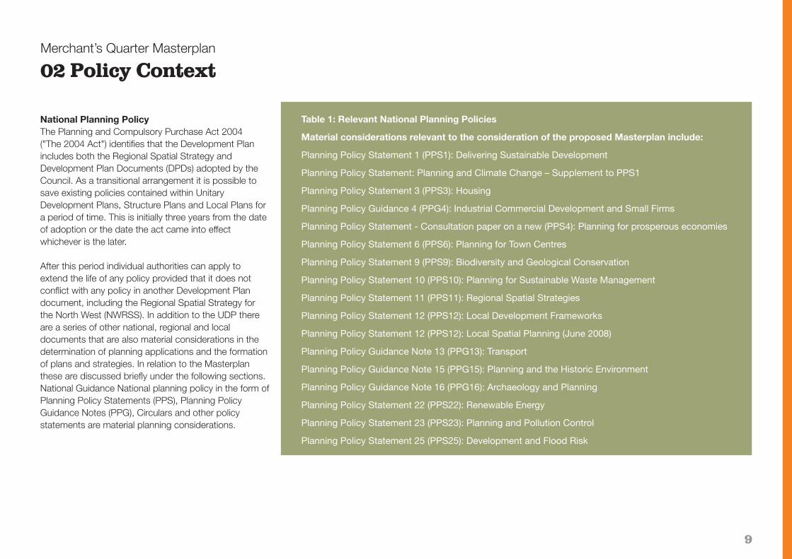
Table 1: Relevant National Planning Policies
Material considerations relevant to the consideration of the proposed Masterplan include:
Planning Policy Statement 1 (PPS1): Delivering Sustainable Development
Planning Policy Statement: Planning and Climate Change – Supplement to PPS1
Planning Policy Statement 3 (PPS3): Housing
Planning Policy Guidance 4 (PPG4): Industrial Commercial Development and Small Firms
Planning Policy Statement - Consultation paper on a new (PPS4): Planning for prosperous economies
Planning Policy Statement 6 (PPS6): Planning for Town Centres
Planning Policy Statement 9 (PPS9): Biodiversity and Geological Conservation
Planning Policy Statement 10 (PPS10): Planning for Sustainable Waste Management
Planning Policy Statement 11 (PPS11): Regional Spatial Strategies
Planning Policy Statement 12 (PPS12): Local Development Frameworks
Planning Policy Statement 12 (PPS12): Local Spatial Planning (June 2008)
Planning Policy Guidance Note 13 (PPG13): Transport
Planning Policy Guidance Note 15 (PPG15): Planning and the Historic Environment
Planning Policy Guidance Note 16 (PPG16): Archaeology and Planning
Planning Policy Statement 22 (PPS22): Renewable Energy
Planning Policy Statement 23 (PPS23): Planning and Pollution Control
Planning Policy Statement 25 (PPS25): Development and Flood Risk

10
Merchant’s Quarter Masterplan
Policy Context
Statement of Community InvolvementBolton Council has prepared and adopted a Statement ofCommunity Involvement (SCI) in accordance with therequirements as set out in the Town and Country Planning(Local Development) (England) Regulations 2004 andGovernment guidance in PPS1; PPS12; Creating LocalDevelopment Frameworks: A Companion guide to PPS12;and Development Plans Examination – A Guide to theProcess of Assessing the Soundness of Statements ofCommunity Involvement.
The SCI sets out the Council’s policy for involving thecommunity in the preparation and revision of all LocalDevelopment Documents, and in development controldecisions within its local area. The SCI provides a basisto inform, consult and involve the wider community inthe LDF process and a significant emphasis has beenplaced on targeting groups that have not traditionallybeen engaged in the planning process such as youngpeople, ethnic minorities and disabled people.
SPD’s whether providing detailed guidance in the formof area specific proposals, including masterplans anddevelopment briefs, or topic based, are not subject toindependent examination and will not form part of thestatutory development plan, however they are a materialconsideration in the planning process. The SCI identifiesthat the production of draft SPD will involve a 6 weekconsultation period taking in a variety of consultationmethods as identified in Appendix 1 and 2 of the SCI.
After the 6 week consultation period has elapsed theCouncil will then consider any representations made,and respond appropriately, indicating whether the SPD
needs to be amended. Once the relevant changeshave been made the Council will then adopt and publishthe SPD.
Regional Economic StrategyThe Regional Economic Strategy (RES) provides aregional framework for economic development, skillsand regeneration in a bid to ensure that activity in theregion is more clearly focused. It identifies five priorityareas – business; skills and employment; regeneration;infrastructure; and quality of life – sets out key aims andobjectives for each, and highlights the activities that theNWDA believes will promote the change necessary totransform the North West economy.
Regional Spatial StrategyThe North West of England Plan Regional SpatialStrategy to 2021 (NWRSS) was adopted and publishedin September 2008 replacing RPG13 (2003) and as aresult of the 2004 Act forms part of the statutorydevelopment plan including ‘saved’ UDP policies andDevelopment Plan Documents as they are adopted andmust be given due consideration when assessingplanning documents such as this SPD.
NWRSS Policy DP1: Spatial Principles – sets out theprinciples which underpin RSS and which have guidedthe principles of this SPD, particularly with regard tosustainable economic development; making the bestuse of resources; and managing travel demand.
Policy DP3: Promote Sustainable EconomicDevelopment – sets out the principles to strengthenregional economic performance and enable the sub
regions, including the Manchester City Region toachieve their potential as well as seeking to addressdisadvantage within specific groups.
Policy DP4: Make the Best Use of ExistingResources – identifies priority to sustainable locationsfor development and a sequential approach todevelopment generally, together with the appropriateuse and reuse of resources. This masterplan promotesthe reuse and conversion of buildings within a previouslydeveloped, centrally located, highly sustainable site andthe Council’s own guidance within the SustainableDesign and Construction SPD sets the Council’sapproach out in more detail.
Policy DP5: Manage Travel Demand – identifies theneed to reduce travel, especially by car such that majorgrowth should be located in urban areas. The Council’saspirations for Merchant’s Quarter are reflective of thispolicy in seeking to make full use of the macro strategicnetworks and public transport and micro improvementsin particular for cyclists and town centre residents,particularly with the creation of a new pedestrian streetand footbridge.
Policy RDF1: Spatial Priorities – is described as the‘cornerstone of the RSS’ and supports the sequentialemphasis of priorities for growth and development within theregion stating that development in Bolton should be of anappropriate scale and accessible location. The developmentof the vision for Merchant’s Quarter has been informed bystudies into the phased growth in the quality of Bolton towncentre’s office accommodation which are sensitive to thepositioning of Bolton within the Manchester City Region.

11
The NWRSS supports the economic programme in theRegional Economic Strategy. Policies W1 and W2 statethat plans and strategies should promote opportunitiesfor economic development with growth opportunities inthe Manchester City Region including financial andprofessional services, media, creative and culturalindustries, ICT, digital and communications. Bolton towncentre is acknowledged as being of regional importancefor economic development and Merchant’s Quartertherefore has the potential to make a significantcontribution to the growth of the regional, sub-regionaland local economies.
Policy W3 – Supply of Employment Land – requiresadequate provision for the supply of B1, B2 and B8 landand seeks to establish a supply of employment landwhich is to be identified in detailed plans, strategies,and proposals. It states that office development should,as far as possible, be focused on regional centres andtown/city centres like Bolton as set out in Policy RDF1consistent with the sequential approach in PPS6.Merchant’s Quarter will therefore contribute to thissupply in accordance with the policy.
To inform the Council’s Local Development Frameworkand Economic Strategies, an Employment Land Studywas completed by Ove Arup & Partners Ltd with KeppieMassie and published in September 2008. The studytakes stock of the existing situation, creates a pictureof future requirements and identifies a new portfolio ofsites. The work is in line with the Guidance Note“Employment Land Reviews” (ODPM 2004). The Studycovers the period up to 2021, with indicative informationto 2026, in line with the NWRSS.
Merchant’s Quarter Masterplan
Policy Context
Policies W5 and W6 support retail and tourismdevelopment in Bolton. Whilst not the primary objectivefor Merchant’s Quarter, small scale retail uses willcomplement the employment generation and creativebusinesses that will be attracted to the area and theprotection of heritage will support the wider tourismoffer of Bolton.
Policy L1 - Health, Sport, Recreation, Cultural andEducation Services Provision, seeks to ensure thatmajor development and regeneration schemes makeappropriate provision for all members of the community.The complementary nature of the planned majordevelopment in Bolton town centre, and its centrallocation with excellent public transport access, ensuresthat all necessary aspects of a sustainable communityare being met including a new Health Research andLeisure Centre; improvements to Queen’s Park; a newCultural Quarter; family-orientated leisure and residentialdevelopments; the co-location of Bolton CommunityCollege and Sixth Form within the University anchoredKnowledge Campus and emerging proposals forprimary school provision.
Policy EM1 aims to identify the region’s assets in orderthat they can be protected, enhanced and managed.The policy identifies the importance of landscape;natural environment; the historic environment; and trees,woodlands and forests; when putting together plansand strategies. The primarily urban development ofMerchant’s Quarter, nonetheless provides manyopportunities for improved biodiversity and protection ofthe natural and physical environment. The Masterplanhas been prepared with this in mind and provides
opportunities for enhanced public realm and softlandscaping, tree planting and management togetherwith the protection and of important buildings andprotected species.
Policy EM2 – Remediating Contaminated Land,encourages the adoption of sustainable remediationtechnologies. In Merchant’s Quarter, the past industrialactivity has left a legacy of contamination, the successfulremediation of which is key to improving the image ofBolton town centre and the region. Developers will berequired to ensure that land is remediated to thesatisfaction of the Council and Environment Agency.
Policy EM3 - Green Infrastructure, aims to deliverwider spatial outcomes that incorporate environmentaland socio-economic benefits through enhanced greeninfrastructure. Section 5 of the SPD sets out theapproach to improved public realm and landscapingincluding the development of green infrastructure withinthe area and along the important corridor to the A666.
Policy EM5 -- Integrated Water Management, aims to ensure that strategies have due regard to the delivery ofthe EU Water Framework Directive including river basis,water company asset plans, flood catchment and floodrisk appraisals. Work is underway on the Strategic FloodRisk Assessment for Bolton town centre and the Environment Agency were consulted in the preparationof this SPD. The River Croal follows a culverted routealong the eastern boundary of the area and developerswill be required to ensure that proposals do not impacton the integrity of this culvert. The Council’s SustainableDesign and Construction SPD, detailed below sets out

12
the mitigation requirements for sustainable developmentproposals.
Section 8 of the NWRSS sets out the Transport Objectives. Policies RT1 – RT4 aim to make the best use of existing infrastructure, manage travel demands,develop a public transport framework and manage thehighway network. Strategies should focus on improvingjourney times reliability in the M61 nationally importanttransport corridor; enhancing the accessibility of gateways and interchanges; locate major developmentclose to good public transport; reduce car travel; makebest use of road space; incorporate maximum parkingstandards; reduce overcrowding on public transport; andimprove road safety.
Merchant’s Quarter is positioned between a strategicgateway to Bolton town centre adjacent to the A666junction leading to the M61 corridor and the site of theproposed Transport Interchange. Plans for the TransportInterchange include the relocation of the bus station to asurface car park site adjacent to the railway station andthe development of an integrated public transport serviceconnected to the Town Centre Gyratory System andwider bus network. A free Metroshuttle bus operates onthe gyratory and serves the Bradshawgate frontage toMerchant’s Quarter with plans to expand the service tothe planned multi-storey car park on Breightmet Street.
The area is therefore very well positioned to play a keyrole in improving this gateway. The proposed Transport and Parking Assessment Supplement will complement the Town Centre Transport Strategy and
Merchant’s Quarter Masterplan
Policy Context
Section Four of this SPD by detailing any furthermeasures necessary to ensure that the capacity of thetransport network is safeguarded whilst incorporatingsustainable parking standards.
Policy RT9 - Walking and Cycling promotes the development of an integrated network of continuous, attractive and safe routes for walking and cycling. Theadopted Public Realm Implementation Framework aimsto promote a pedestrian friendly town centre throughthe improvement of public realm on existing streets andthe development of new routes and spaces. The Transport Strategy identifies cycle routes across thetown centre with highway improvements dedicated tosafe cycle lanes. In Merchant’s Quarter, as well as amajor programme of public realm improvements, thereare proposals for a new pedestrianised route linkingthree new public spaces over an important new footbridge to connect the area to the core town centreand cycling facilities will be an essential part of new development proposals.
In November 2008, the Government published its proposals for the Sub-National Review seeking to establish Regional Leaders Boards like 4NW in each ofthe regions of England. Legislation would be required togive bodies like 4NW and the NWDA joint responsibilityfor producing RS2010, the region's single regional strategy, which ultimately will replace both the RES andNWRSS. A Principles and Issues Paper was launchedfor full public consultation for 12 weeks from 3rdFebruary 2009.

13
Policy DescriptionN1 Nature conservationN5 Landscape featuresN7 Trees, woodland and hedgerowsN9 Species protectionEM1 Environmental ManagementEM2 Incompatible usesEM3 PollutionEM4 Contaminated landEM5 Derelict land and buildingsEM6 Energy conservationEM7 Renewable energyEM10 Surface water runoffEM11 Flood protectionD1 Design and the built environmentD2 DesignD3 LandscapingD4 AdvertisementsD5 Public artD6 TelecommunicationsD14 ArchaeologyD15 Archaeology reportO1 Open space and recreationO4 Open space in new developmentsO7 Public rights of wayA1 AccessibilityA3 Travel plansA4 Developer contributionsA5 Roads, paths, surfacing and car parkingA6 Car parking standardsA7 Cycle parking
Bolton Unitary Development PlanThis Masterplan will expand on policies set out in theBolton Unitary Development Plan (UDP) adopted in April2005. This takes into account the latest regional and national guidance. The most relevant UDP policies arelisted in Table 1 although policies not included on the list may be still relevant to individual applications.
Merchant’s Quarter Masterplan
Policy Context
Table 2: Relevant Unitary Development Plan Policies
Policy DescriptionA8 Major development (access)A9 Access for people with disabilitiesA10 Traffic management and calmingA16 PedestriansA17 CyclistsA18 Strategic Route NetworkA19 Road Schemes/ImprovementsA20 Transport measuresA21 Planning obligationsH1 HousingH3 Determining housing applicationsH4 Affordable housingH5 Housing densityE1 Employment and the economyE2 Office, industrial and warehouse allocationsE3 Siting of offices and industrial developmentE5 Protection/regeneration of existing
employment areasE6 Improvement of existing industrial areas
and premisesT8 TourismS1 Retail and leisureS3 Retail on unallocated sites within centresS7 Hot food takeaways and restaurantsS8 LeisureTC1 Town centresTC2 Town centre livingTC6 Expansion, conversion or redevelopment of
commercial areasTC7 Multi-storey car parksTC10 In-town car parking

14
Further details of these policies can be found in theadopted UDP which is available on the Council’s website at www.bolton.gov.uk. Alternatively, copies ofthe policies are available for viewing at Bolton Town Hall.
The focus for the regeneration of Merchant’s Quarter willbe Class B1 office space. Policies E2, E5, TC6 and TC7are relevant to specific areas of Merchant’s Quarter asshown on Figure 2. In particular the area bounded byBreightmet Street, Bradshawgate, Bridgeman Place andRiver Street is identified in the UDP for office, industrialand warehousing uses.
Policy E2 states:“The Council will permit office, industrial andwarehouse (B1, B2, and B8) development on theallocated sites as shown on the Proposals Mapand the Town Centre Inset Map.”
The reasoned justification to Policy E2 goes on to advise that allocations developed for B1, B2 and B8uses under this policy will then be subject to protectionunder Policy E5 which sets out criteria against which alternative proposals should be assessed. Such proposals will be permitted providing the benefits outweigh any disadvantages.
Policy TC6 states:“The Council will permit the expansion, conversionor redevelopment of the sites and premises for theuses identified below, as shown on the Town Centre Inset Map: (i) 45E Shiffnall Street 4.2ha (Primarily Use Classes B1, B2, B8)”
The reasoned justification for TC6 explains that Boltontown centre has established commercial areas which theCouncil see as a valuable asset and which add to itsoverall vitality and viability. It is the preferred location forbusiness development with prime communication linksand a high standard of environment. The continuation ofsuch uses and their development in the town centre willbe encouraged and promoted. Merchant’s Quarter offers an opportunity for redevelopment and re-use andalso benefits from close proximity to higher educationand accessibility by all modes of transport.
Appendix 5 of the UDP refers to 42E Shiffnall Street andstates that many of the buildings and in particular theroad network are inappropriate in terms of providing amodern commercial industrial environment. Redevelopment and/or reuse of buildings should aim toimprove the situation.Policy TC7 protects that part of thesite for multi-storey car parking, in particular MCP2Breightmet Street. TC7 identifies exceptions including alternative provision or where it can be proven that thereis no need for the facility. Since adoption of the UDP inApril 2005 the Council has adopted and published a CarParking Strategy and Transport Strategy for the towncentre which identifies a more focused proposal forBreightmet Street. This is further identified in the adopted Breightmet Street Development Brief and in 2008 the
Council confirmed its partnership arrangements withNCP to deliver three new multi-storey car parks includingTC7. The full extent of this area is therefore no longer required for car parking being confined in the easternmost portion of the allocation.
The Council’s aspirations are for a mix of complementaryuses within Merchant’s Quarter both within and outsidethe core area defined by Policies TC6, E2 and E5. It isanticipated that these uses will include retail, leisure(restaurants, bars, cafes) hotel and additional car parkingfacilities. The UDP policies support a mixture of useswithin the town centre. UDP Policy TC2 supports towncentre living and outside the core area, proposals forresidential development will be considered on their meritsagainst the relevant policies. It is anticipated that suchproposals will form part of a mixed use scheme.
Within the core area protected by Policies TC6, E2 andE5, residential development will only be considered as anancillary and minor element within a mixed use proposalthat delivers the necessary employment and other complementary uses and in any case such proposals will be rigorously tested against the criteria set out in Policy E5 and Policy MU5 below. It is anticipated that development proposals will fully support and contributeto the requirements of the Council’s adopted PublicRealm Implementation Framework (PRIF) as set out inthe Town Centre Planning Obligations Policy, (see pages54 and 55).
Merchant’s Quarter Masterplan
Policy Context

15
Merchant’s Quarter Masterplan
Policy Context
Development proposals will need to ensure that the biodiversity within and around Merchant’s Quarter issafeguarded and enhanced in accordance with PPS9,RSS Policy EM1 and the UDP and in particular will berequired to submit landscape assessments, tree surveysand wildlife or biodiversity impact assessments whereknown assets, landscape features or protected speciesare affected. Proposals for demolition of buildings willneed to be supported by surveys for bats.
Developers and applicants should refer to the PlanningValidation Checklist available on the Council’s website or by contacting Planning Control for full details of thesupporting information required for any planning applications to be registered and determined.
Further guidance is provided by Planning Control PolicyNotes. Those that are most relevant to Merchant’s Quarter are listed in table 2.
Table 3: Relevant Planning Control Policy Notes
PCPN Description4 Shop fronts6 Display of signs and adverts7 Trees: protection and planting in
new development9 Location of restaurants, cafés, public
houses, bars and hot food takeaways in urban areas
10 Planning out crime17 Nature conservation18 Provision for cyclists21 Highways considerations22 Public art25 Telecommunications26 Affordable housing27 Housing developments

16
Merchant’s Quarter Masterplan
Policy Context
Figure 3 Bolton Town Centre Character Areas

17
Merchant’s Quarter Masterplan
Policy Context
Bolton: Our Vision 2007-2017 (Community Strategy)Bolton’s Community Strategy identifies six prioritythemes within the two key aims of narrowing the gap between the most and least well off and ensuring economic prosperity. A thriving Merchant’s Quarter willdeliver a major contribution to the economic prosperityof Bolton by providing a significant number of jobs withina sustainable, regenerated environment. Located withinthe town centre, these jobs will be accessible to a widerange of people. An improved environment will contribute to a reduction in crime and opportunities forcrime within cleaner streets and better open spaces.Merchant’s Quarter has the potential to become a destination and neighbourhood in its own right deliveringsignificant community benefits.
Bolton Town Centre Action Framework 2005-2008(TCAF)In 2005 the Council set a context for decision makingand action that describes the background to and issuesthat surround the town centre and the use of its facilitiesand opportunities. The TCAF sets out some of the keyactions to be taken and future aspirations. Its purpose isto guide the development of proposals and programmesthat will affect the town centre and ensure that changesto the town centre help to contribute towards the endproduct and Community Strategy themes. Many of thestrategies envisaged by TCAF such as the PositionStatement and image and profile, now captured in theBolton brand, have since either been published or arecurrently being researched. Some are summarised further below.
The TCAF adopts an area-based approach to the planning of development that sets the context of Boltontown centre through its distinctive character and useareas, within the periphery as well as the inner core thushelping address the loss of status that many of theseareas have suffered in relation to the civic core. It identifies the distinctive pattern of streets and buildings within Merchant’s Quarter (formerly ‘Bridgeman Place’) Area of Change and the positivetransport links. Acknowledging the contribution of themanufacturing industry to the local economy, it notesthat much of Bolton’s educational institutions were originally developed to serve it. The transformation ofthe area towards a mixture of uses focused on office together with redevelopment of the Westbrook site tothe south is anticipated.
Building BoltonThe Council has adopted a Supplementary PlanningDocument, ‘Building Bolton’ which provides designguidance for new development in the town centre basedon the principle of enhancing local distinctiveness inBolton’s townscape. This has identified a consistent pattern of damaged townscape the ‘shatter zone’ peripheral to the main civic and retail core. This zonehas generally suffered from urban clearance in recentdecades, yet retains characteristic patterns of buildings,topography and public spaces which deserve to beprotected from further redevelopment pressures. The Council encourages redevelopment in these areaswhich respects and responds to its context. BuildingBolton has been updated to reflect this Masterplan SPDwhich contains references to the design principles.
This document provides a detailed character appraisalof the area and sets out detailed guidance on the designof any new development. This has been reflected in themaster planning process and the latter sections of thisdocument.
Sustainable DevelopmentDevelopers should refer to the new Government document, “Securing the Future – UK Government Sustainable Development Strategy”. This aims to placesustainable development at the heart of the land useplanning system and at the core of new planning guidance. The Council has adopted a SupplementaryPlanning Document on Sustainable Design and Construction which provides advice and guidance oncarbon and renewable energy, biodiversity, sustainabledrainage and water use, material and constructionwaste, and waste management and recycling.
The regeneration of Merchant’s Quarter presents an opportunity for comprehensive development to includeproposals that will benefit the whole area, such as greenenergy generation or waste management. Individual development proposals will be expected to fully embrace this SPD and the guidance in PPS1, PPS10and PPS22, RSS and the UDP.
In particular NWRSS Policy EM11 sets out guidance on Waste Management Principles and applications for planning permission will be required to include proposals for waste minimisation as part of their submission in accordance with the Sustainable Designand Construction SPD. The core area of Merchant’sQuarter is unlikely to present opportunities for
18
Merchant’s Quarter Masterplan
Policy Context
centralised recycling facilities or amenity sites because of the requirements to develop the sites to back of footway and maximise the enclosure and investment opportunities. However, the Breightmet Street North site, due to its shape and planned use for access andparking, may present opportunities for centralised recycling facilities which should be explored as part ofany proposals for the development of the area.
Breightmet Street Development BriefThe Breightmet Street Development Brief sets out guidance to inform the development of that part of Merchant’s Quarter, mainly occupied by a surface levelcar park in Council ownership and located betweenBreightmet Street and the Bolton to Blackburn railway.The existing car park was built on the site of a formerrailway coal yard. The site also includes a modern privately owned office building, Tymark House, constructed in 1995. To the east is an area of openspace with dense tree cover which separates the sitefrom St. Peter’s Way. A car repair garage is located tothe west of the site.
The development brief proposes a 600 space multi-storey car park on the eastern portion of the site.In addition to the car park the development brief advisesthat the site has the potential to accommodatecommercial office development together with associatedancillary uses including cafés, bars and restaurants. Thebrief also acknowledges the proposals within PRIF for apedestrian bridge over the railway line connecting toInstitute Street and the town centre core.
The development is intended to complement and support the broader regeneration of Merchant’s Quarter.This document has been the subject of consultation andis a statement of Council policy, the key elements ofwhich are included within and superceded by this SPD.
Coming to Bolton - Town Centre Transport StrategyThe Town Centre Transport Strategy (TCTS) aims to provide an efficient, sustainable transport system, whichwill offer a realistic choice of transport modes to andwithin Bolton town centre and thus enhance the vitalityand viability of the town centre.
The Council commissioned Peter Brett Associates to undertake a study into patterns of car parking in thetown and how arrangements to meet the ongoing demand for car parking will be affected as town centredevelopments take place. This recommended the reduction of the amount of land taken by surface levelcar parking and identified edge of centre sites includingBreightmet Street for multi-storey car parks.
The site lies adjacent to the outer highway box and is located adjacent to the inner core. A number of keycomponents of this impact upon the Masterplan area.These include:� Reduction of traffic from the inner core.� Creation of a bus circulation route (also used
for servicing).� Increased pedestrianisation within the inner core.� Proposals for car parks adjacent to the inner core in
order to remove traffic.
Specific proposals which will impact upon the Masterplanarea include: � A multi-storey car park on Breightmet Street - now
to be delivered though the Council’s partner NCP.� A new access road from the St Peter’s Way Slip Road
linking to River Street providing access to the Breightmet Street Car Park.
� Alterations to the junction of Trinity Street / LowerBridgeman Place / Bridgeman Place to be fundedfrom the Transport Infrastructure Fund (TIF) with estimated costs of £3.1m. These works have been completed.
Public Realm Implementation Framework 2007-2012In June 2007, the Council adopted a town centre Public Realm Implementation Framework (PRIF). TheFramework is divided into three parts:
Stage 1: Public Realm StrategyThe Public Realm Strategy provides a framework visionbased on an overview of the public realm issues in thetown centre. It sets out a rationale and structure for thefuture public realm which can be used as a basis for theidentification of environmental improvement projects, andas the context for all town centre activities and initiativeswhich relate to the public realm.
Stage 2: Public Realm Design BaselineThe Public Realm Design Baseline provides clear design guidance to those implementing public realm improvements. It sets out design principles on a town-wide scale and categorises the streets and spacesas set out in the Public Realm Strategy.

19
Merchant’s Quarter Masterplan
Policy ContextIt goes on to set out recommended surfacing materials,furnishings, planting and lighting, therefore enabling theCouncil to ensure consistency of design and quality inthe creation of the public realm.
Stage 3: Public Realm Implementation FrameworkThe PRIF formalises the link between Stage 1 and Stage2 and identifies the key feasibility issues for each project.The PRIF provides detailed guidance on the public realmimprovements that will be required as part ofdevelopment proposals, to enhance the regeneration ofMerchant’s Quarter.
Other DocumentsIn addition to the PRIF, the following documents havealso influenced the Masterplan process:� Economic Development Strategy for Bolton� Bolton Town Centre Planning Obligations� Bolton Crime & Disorder Strategy� Bolton Local Transport Plan� Bolton Housing Strategy� Bolton Cultural Strategy� Bolton Tourism Action Plan� Environmental Strategy� Bolton Borough Public Art Strategy

20
Within this section, the existing characteristics of Merchant’s Quarter are analysed in detail forming abaseline and context for the development of the masterplan in Part Four.
Site analysisFigure 4 indicates an urban design analysis of the site.The key points to be derived from this can be summarised as follows:
� Frontages - Positive frontages, strong grain, key barriers along north, east and southern edges.
� Levels - There are variations in levels across the site.
� Access - Main access and egress points are from Haulgh Bridge, Lower Bridgeman Street, and Bridgeman Place. Secondary access and egress points are from Bradshawgate.
� Movement / Permeability - Characterised by a gridof north-south and east-west routes. No connectionsacross railway to the north and dual carriageway to the east.
� Nodes (road junctions) - Structural weaknesses to Bradshawgate / Breightmet Street junction.
� Visual Amenity / Environment - Green space alongeastern edge currently under used.
� Views - Landmarks both within and outside the site are visible along key roads. Landmark buildings and chimney stack.
Merchant’s Quarter Masterplan
03 Analysis
Figure 4 Urban Design Analysis

21
Merchant’s Quarter Masterplan
Analysis
Landscape characterFrom the 2006 aerial photograph at Figure 5 the urbanindustrial character with a strong street grid is very clear.The River Croal originally formed a natural landscapefeature to the east of the area but was culverted in the1960's to facilitate the A666 St Peter’s Way. A maturegreen buffer flows along the eastern edge of Bolton towncentre sloping down to the highway in an embankmentin close proximity to the former line of the Croal.
This linear green corridor contains a number of trees,some of which provide an amenity value, particularly onthe northern part of the open space. The embankmentprovides a green foil, framing views into, and through theQuarter, from west to east. There are pockets of greenspace to the north, around St Peter’s Church, and to thesouth, adjacent to the River Croal as it emerges from theculvert south of Bradford Street. In parts, however, thegreen space requires improved maintenance.
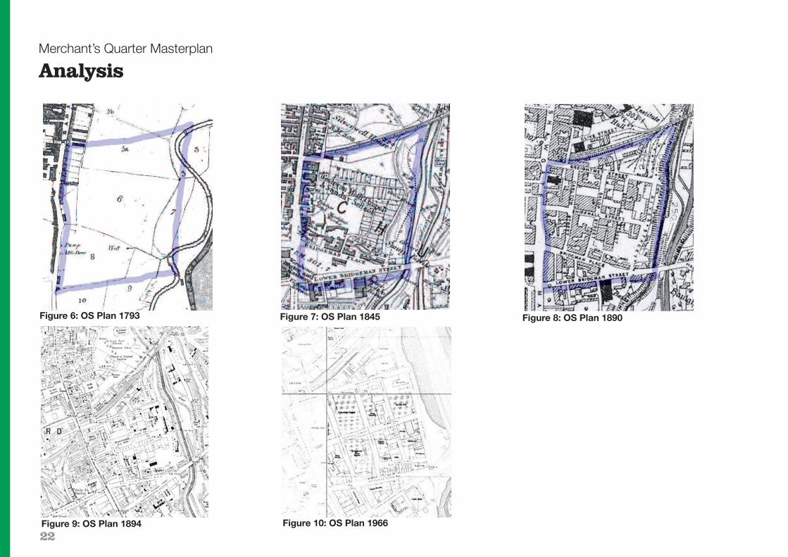
Historical analysisEarly maps show how the area developed in the firstdecades of the 19th Century, initially in response to local demand for agricultural produce. Industry soon replaced intensive farming, benefiting from the rail andcanal links and a well planned street grid, an industrialequivalent of the town planning around Victoria Square.Some of the largest mills in the country were constructedin Bolton throughout the industrial revolution.
The Masterplan area developed rapidly in the firstdecades of the 19th Century, with the remaining warehouses being built largely between 1847 and 1910.
The street grid allowed subdivision of the site into rectangular plots suitable for a range of industrial uses.They accommodated a mix of uses including a brewery,transport depot and various foundries and textile mills.Many of the buildings around Shiffnall Street and RiverStreet originally housed associated cotton mill businesses. Each use had a characteristic building plan,
Figure 5 Aerial Photograph 2006
and this variety remains an important visual attribute ofthe area.
The street names reflect the local landowning interests of the Bridgeman family, Earls of Bradford, whose longinvolvement with Bolton included the development of the early railway system.
22
Merchant’s Quarter Masterplan
Analysis
Figure 6: OS Plan 1793 Figure 7: OS Plan 1845 Figure 8: OS Plan 1890
Figure 9: OS Plan 1894 Figure 10: OS Plan 1966
23
Merchant’s Quarter Masterplan
Analysis
Character areasBuilding Bolton contains a detailed analysis and character appraisal of Merchant’s Quarter, part of the industrial ‘Ring of Fire’ which originally surrounded thetown centre. The appraisal acknowledges the logicalstreet pattern, use of materials, identifies weaknesses including gap sites and explains the significance of theindustrial architecture.
In terms of architecture it concludes that generally building elevations are sparingly detailed; mostly regularbays of segmental arched windows, though officefrontages are often elaborated with stone dressings.Solid building corners make the most of the multiplestreet intersections and the regular bay rhythm of milland warehouse frontages are often articulated with shallow vertical window bay recesses, breaking up thelong horizontals and emphasising the structural grid.
Distinctiveness arises out of the regular ordering of functional elements - doors, window openings, loadingbays - enlivened with ironwork, stone dressings to officedoorways and cast iron rainwater goods. Materials aretypical of late 19th / early 20th century industrial design -red engineering brick, with tough iron furnishings. Stonedressings occur - both ashlar detailing, and rusticatedstone plinths. Windows are important here: large, set inshallow reveals, with slim metal or wood glazing bars.
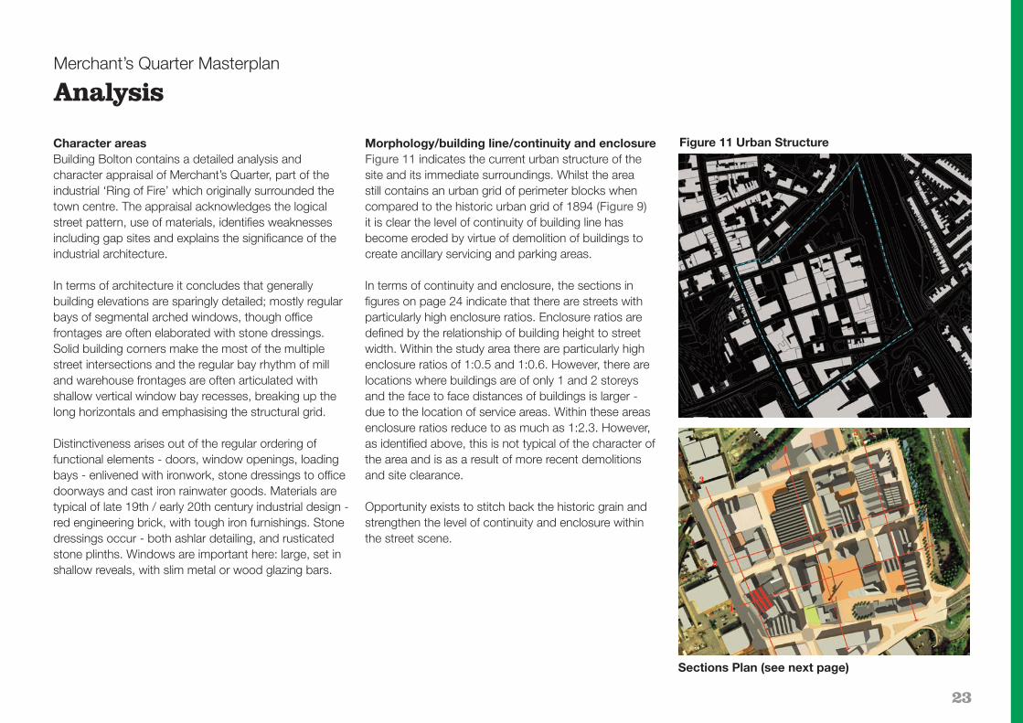
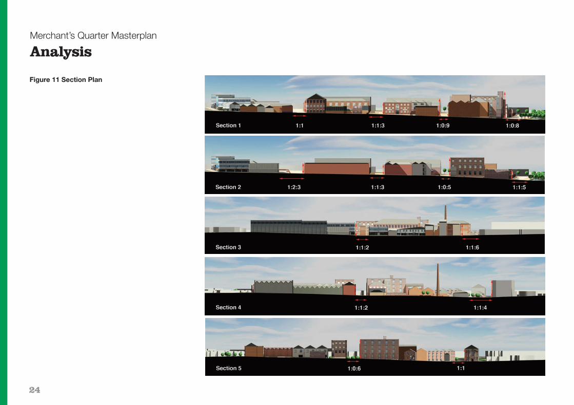
Morphology/building line/continuity and enclosureFigure 11 indicates the current urban structure of thesite and its immediate surroundings. Whilst the area still contains an urban grid of perimeter blocks when compared to the historic urban grid of 1894 (Figure 9)it is clear the level of continuity of building line has become eroded by virtue of demolition of buildings tocreate ancillary servicing and parking areas.
In terms of continuity and enclosure, the sections infigures on page 24 indicate that there are streets withparticularly high enclosure ratios. Enclosure ratios aredefined by the relationship of building height to streetwidth. Within the study area there are particularly highenclosure ratios of 1:0.5 and 1:0.6. However, there arelocations where buildings are of only 1 and 2 storeysand the face to face distances of buildings is larger -due to the location of service areas. Within these areasenclosure ratios reduce to as much as 1:2.3. However,as identified above, this is not typical of the character ofthe area and is as a result of more recent demolitionsand site clearance.
Opportunity exists to stitch back the historic grain andstrengthen the level of continuity and enclosure withinthe street scene.
Figure 11 Urban Structure
Sections Plan (see next page)
24
Merchant’s Quarter Masterplan
Analysis
Figure 11 Section Plan

25
Merchant’s Quarter Masterplan
Analysis
Scale, massing and rooflineFigures 12 and 13 indicate a range of heights across the site ranging from single to six storeys including thatproposed for Merchants Place No.2 on River Street.Many of the blocks contain small changes/variations inscale, resulting in a variety of roof forms across the site,including flat roofs, hips and ridges and the interplay andrelationships between these buildings form a strongcharacteristic of the Quarter. Some of the more modernadditions facing Bradshawgate contain flat roofs and result in a monotonous roof-line.
Clearly the scale and massing of buildings throughoutthe Quarter has developed organically over time withoutthe application of urban design principles. Opportunityexists through building replacement to apply an urbandesign approach to scale and massing in order to framevistas and define a hierarchy of streets and spaces.
Figure 12: Axonometric aerial photograph overlay
Figure 13: Scale and massing plan

26
Figure 14: Building Quality (source: Building Bolton)
Merchant’s Quarter Masterplan
Analysis
Buildings of high value interms of their contributionto local distinctiveness. This may includearchitectural, cultural,historic or archaeologicalvalue. These buildings willcharacterise a particulararea, or the whole towncentre, and will provideprecedents for adjacentredevelopment in terms ofscale, materials andmassing.
Building types characteristicof the area in terms of use,scale or materials choice,but with lesser architecturalor symbolic value.
27
Merchant’s Quarter Masterplan
Analysis
Building Quality: Local distinctivenessFigure 14 indicates a Character Area Appraisal, utilisingthe methodology established within Building Bolton. Theappraisal has been updated as part of the developmentof this SPD. Whilst there are no specific listed buildings,or conservation areas within the study boundary thereare some buildings of high value in terms of their contribution to local distinctiveness. These buildingscharacterise the area and provide some precedents foradjacent redevelopment in terms of scale, materials and massing.
Whilst it is the Council’s preference to see these buildings retained or incorporated in part or in full wherepossible as part of any proposed development, thestructural condition and economic viability of doing so,together with the quality or nature of the proposed development will be factors that the Council will consideras part of any proposals for partial or full demolition.
Figure 14 also identifies a number of buildings, including the chimney, within the site that are of lesserimportance and value in terms of their contribution tolocal distinctiveness but are characteristic of the area interms of use, scale or materials. It is likely that thesebuildings will not be suitable in terms of accommodatingthe scale and use mix envisaged under the masterplanvision, nor will they be appropriate in terms of urban design, and therefore, there removal will not adverselyimpact on the character of the study area providing proposals contain appropriate proposals for replacement. Developer proposals should neverthelessseek to retain such buildings in the first instance and include an assessment of the existing buildings with
regard to structural condition and economic viability tojustify their demolition.
The remaining buildings and structures are of negligiblevalue or importance in terms of their contribution to thecharacter of the area and should be demolished to enable development proposals for buildings whose architecture and urban design are of an appropriatescale and high quality, in accordance with the Masterplan.
Building Quality: Structural conditionThe Council has carried out structural condition surveyson the buildings of high value together with the buildingsforming the Saville Mill complex though excluding Merchant’s Place No.1 and the proposed Merchant’sPlace No.2 (former Blackburn’s Mill) which has full planning permission for part conversion. Due to the ageof the high value buildings, significant costs in their retention, conversion and re-use have been identified inall cases and some buildings are in a very poor structuralcondition with the potential for major costs in bringingthe buildings up to modern Building Regulations standards should they be retained.
In particular, the surveys identify major problems withBridgeman Place Works, Globe Mill and the rear part of111/113 Bradshawgate. Developers would be requiredto carry out further detailed survey work. It is likely thatthe majority of the Saville Mill complex will need to bedemolished because of its poor, and in some parts dangerous, condition.
Use MixFigure 15 indicates existing building and land uses within Merchant’s Quarter with the core buildings predominantly used for various industrial, warehouse andbusiness uses including car workshops, foundry, plasticmanufacturing, window manufacturing and a plumbingmerchant. There are concentrations of secondary retailand car showrooms facing Bradshawgate and somesmaller scale retail warehouse units and cafés within the core area. Grade A office space is provided at Merchant’s Place No.1 and some office uses exist in thecore area. There is limited use mix within the buildingsthemselves although some examples of offices within industry, however these uses are generally ancillary tothe overall use of the site.
Merchant’s Quarter currently has no night-time ‘destinations’ with the exception of the surface carparks. Some of the buildings are empty and in a poorstate of repair, whilst others like parts of the Saville Millcomplex are derelict and have a significant detrimentalimpact on the visual appearance of the area. Given thatthe majority of uses within the area cease operationsafter 6pm, this has resulted in the area feeling empty anduninviting during the evenings and after dark, or evenduring quiet parts of the day or when the weather is dull. This significantly impacts on the feel of the area,and has resulted in a perceived lack of safety and security and criminal activity. This historically, togetherwith its ready accessibility and close proximity to thetown centre, has made the area attractive for anti-socialbehaviour. The historical activities associated with crimeand anti-social behaviour has further exacerbated theuncongenial nature of the area during the evening and

28
prohibited the economic regeneration of the area. Theanti-social and criminal behaviour is subject to targetedaction by the BSafe Partnership, which is successfullydelivering very significant reductions in criminal activity.
Figure 16 indicates the high proportion of land within Merchant’s Quarter which is attributed to parking and servicing.
Figure 15: Building Uses Figure 16: Land Uses
Merchant’s Quarter Masterplan
Analysis
Industrial

29
Merchant’s Quarter Masterplan
Analysis
MovementFigures 17 and 18 indicate the existing pedestrian andvehicle movement through the Masterplan area. Figure17 illustrates that there is a one-way entrance point intothe site from Ash Street into Carlton Street, via LowerBridgeman Place and from Lower Bridgeman Place intoRiver Street. There is a separate one way exit loop ontoLower Bridgeman Place from Salop Street. There is aone way exit from River Street onto St Peters Way(A666), heading north.
There are currently two access and egress points ontoBradshawgate. A two way access exists onto ShiffnallStreet and an exit only from Breightmet Street. This wasintroduced by the Council due to a weak, shallow railwaytunnel under the road and adjacent building.
Vehicles currently use the area as a rat-run to by-passthe lights at the junction of Bridgeman Place and Bradshawgate, particularly if they wish to head north on the A666.
In terms of pedestrian movement, the main pedestrianflows within the area occur between the surface car park on Breightmet Street and the town centre alongBreightmet Street. There is also a pedestrian routethrough to Church Bank which provides a quicker access to Churchgate and ultimately Church Wharf.Although the lack of natural surveillance over this route,make it a less attractive proposition for pedestrians.
Figure 17: Vehicular Movement Routes Figure 18: Pedestrian Movement Routes

30
Public realmFigure 19 indicates the distribution of public realm,streets and spaces within the wider locality of the towncentre. The diagram indicates that the site forms a voidwithin a wider public realm / open space network. Thereare a number of pedestrianised streets and squares tothe north west of the site focused on Victoria and NelsonSquare, and Newport Street and Le Mans Crescent.
There is also a significant area of landscaped openspace around St Peters Church, immediately to thenorth of the site.
The Council’s adopted Public Realm ImplementationFramework (PRIF) includes a detailed assessment of thepublic realm baseline, quality and opportunities withinMerchant’s Quarter.
Figure 19: Public Realm Distribution
Merchant’s Quarter Masterplan
Analysis

31
Merchant’s Quarter Masterplan
Analysis
Figure 20 Opportunities and Constraints

32
Figure 21 Statutory Services
Merchant’s Quarter Masterplan
Analysis

33
Merchant’s Quarter Masterplan
04 Masterplan
Masterplan and policiesThis final section sets out the future and proposed regeneration of Merchant’s Quarter, expanding on thebackground and planning policy, especially RSS andUDP Policies and SPD, in Part Two and the baselineanalysis in Part Three. The masterplan comprises aseries of guidelines and illustrative plans, the intendedweight to be attached to each being explained in therelevant text. Within the masterplan section, keyprinciples are identified within green boxes as policiesthat expand on those within the RSS and the UDP.
Opportunities and constraintsBased upon the foregoing detailed analysis, Figures 20and 21 describe the key constraints and opportunitiesfor the SPD area. These include:
Constraints� Historic grid / street pattern – This positive constraint
provides the primary characteristic of the Merchant’sQuarter and allows visual and physical permeability. Unless enhancing this structure, new development should not normally remove elements of the existing street grid.
� Buildings of high value to local distinctiveness are also a positive constraint. There are a number of buildings which although not listed, are of a high value in terms of local distinctiveness and therefore should be retained as part of any future development opportunities subject to structural condition and economic viability.
� The structural condition and economic viability of building retention will be a constraint on the conversion of high value buildings and structures.
� The green embankment to the east of the area contains a number of trees. Any development within this zone should be supported by a full tree survey and the area should be subject to a woodland management plan to maintain the integrity of the area whilst safeguarding the safety of pedestrians using footpaths in the vicinity and the visual appearance of the area.
� The existing services / utilities within the area and in particular under the highways and footways, provide a restriction to the design of the public realm, particularly in terms of providing street planting, on-street parking and street furniture.
� The culverted River Croal within the embankment between River Street and the A666 will impact upon any development on this part of the site and development proposals will need to safeguard the structural integrity of the culvert in consultation with the Environment Agency.
Opportunities� The primary opportunity is to regenerate the area
with high quality office space complemented by a range of uses, including the potential to create a hubfor creative businesses, that will add to the activity and diversity in the area.
� New buildings are set on the back of footway to provide continuity and enclosure to the streets and spaces and will reinforce the existing perimeter blocks. This will enhance the street grid and maximise use of key views such as that of St Peter’s Church along Saville Street.
� Opening parts of the urban blocks up to provide new urban spaces, based around key pedestrian footfalls.
� Extending Saville Street and creating a new landmarkpedestrian bridge link across the railway to Institute Street connecting the area to an east/west route across the heart of the town centre.
� Opening up accessibility to the green embankment toprovide useable pocket green spaces and managing the planting and soft landscaping.
� The provision of additional parking facilities within the area around its periphery to the north and east including multi-storey car parking will complement theTown Centre Transport Strategy and provide sufficientprivate contract parking spaces to serve the level of office development proposed within Merchant’s Quarter, together with public parking spaces.
� A new landmark building to the southeast of River Street would help define the south east gateway to the town centre.
� The provision of pedestrianised zones and pedestrianpriority zones within the area, particularly along key pedestrian desire lines help to create a walkable and pedestrian friendly environment.
Masterplan conceptThe existing high quality buildings identified within theanalysis, the historic street pattern and the green space, provide the building blocks for developing the exciting concept and vision for Merchant’s Quarter. Thevision is based on strengthening character and local distinctiveness by re-establishing the area’s connectionwith its historical development.

34
Merchant’s Quarter Masterplan
Masterplan
Taking the urban block as the framework for the area,the existing high quality buildings are converted to appropriate uses, primarily commercial office space - asdefined by the masterplan. New high quality building additions further define the blocks to provide continuityand enclosure along key streets and connections.
However, in order to provide the space for the buildingsto function effectively in terms of parking and servicing,as well as active gathering, the blocks contain voids.These voids are filled with public squares, private andpublic courtyards, servicing and parking areas. Their location within the grid is defined by the masterplan and influenced by the requirement to create hubs, destinations, footfall and connectivity. These public andprivate areas are connected through a series of atriawhich reveal the activities to passers-by.
The vision is for a truly mixed-use area, with activeground floor uses, offices, creative businesses, a hoteland some residential where appropriate, thus creating avibrancy throughout the day and night.
The integration of old and new buildings base their character on historical cues from retained and former buildings.
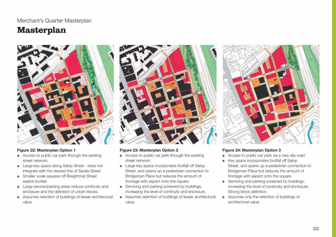
The Masterplan: Option DevelopmentFigures 22 to 24 indicate the Masterplan options which were explored for Merchant’s Quarter. The mainvariations relate to the location of the key space, accessinto the site and the level of building retention.
In terms of the buildings to be retained and removed,Figure 22 and 23 identify the retention of buildings oflesser architectural value, but which are characteristic ofthe area. There are a number of buildings that fall withinthis category that are not worthy of retention, nor wouldthey be suitable for accommodating the types of uses promoted within the vision. Over a 10-15 year programme some of the buildings would be removed -as identified in Figure 24 - subject to a more detailedbuilding assessment.
In relation to the distribution of squares and spaces,whilst all options include Carlton Street and SavilleStreet, the preferred option for the central square capitalises on the footfall of Saville Street and maximises the amount of frontage with aspect onto the square, as identified within Figure 24.
Options for the movement strategy are explained onpage 38 in more detail. However, Figures 22 and 23
indicate options for accessing the site through the existing street network. Figure 24 illustrates the preferred slip road access off St Peter's Way, to themulti-storey car park at Breightmet Street as envisagedin the Transport Strategy. Further design work has resulted in the revised route for the slip road which connects directly into Breightmet Street rather thanShiffnall Street (Figure 26).
Option 3 is the preferred masterplan solution which has been further developed into the main masterplan diagram shown at Figure 25. This masterplan indicateshow the Council would prefer to see the regeneration of Merchant’s Quarter brought forward and illustratesthe key principles contained within this SPD such asprotection of the street grid; creation of public spaces;buildings that should be retained; urban design principles; public realm treatment; location for parking;and movement strategy. The masterplan is not, however, a definitive plan of the precise way each blockshould be brought forward for development as this willdepend on further detailed analysis, investigation anddesign that will be influenced by architects, ground conditions, building conditions and economic viability.
35
Merchant’s Quarter Masterplan
Masterplan
Figure 23: Masterplan Option 2� Access to public car park through the existing
street network.� Large key space incorporates footfall off Salop
Street, and opens up a pedestrian connection to Bridgeman Place but reduces the amount of frontage with aspect onto the square.
� Servicing and parking screened by buildings, increasing the level of continuity and enclosure.
� Assumes retention of buildings of lesser architecturalvalue.
Figure 24: Masterplan Option 3� Access to public car park via a new slip road� Key space incorporates footfall off Salop
Street, and opens up a pedestrian connection to Bridgeman Place but reduces the amount of frontage with aspect onto the square.
� Servicing and parking screened by buildings, increasing the level of continuity and enclosure.Strong block definition.
� Assumes only the retention of buildings of architectural value.
Figure 22: Masterplan Option 1� Access to public car park through the existing
street network.� Large key space along Salop Street - does not
integrate with the desired line of Saville Street.� Smaller scale squares off Breightmet Street
exploit footfall.� Large service/parking areas reduce continuity and
enclosure and the definition of urban blocks.� Assumes retention of buildings of lesser architectural
value.

36
Merchant’s Quarter Masterplan
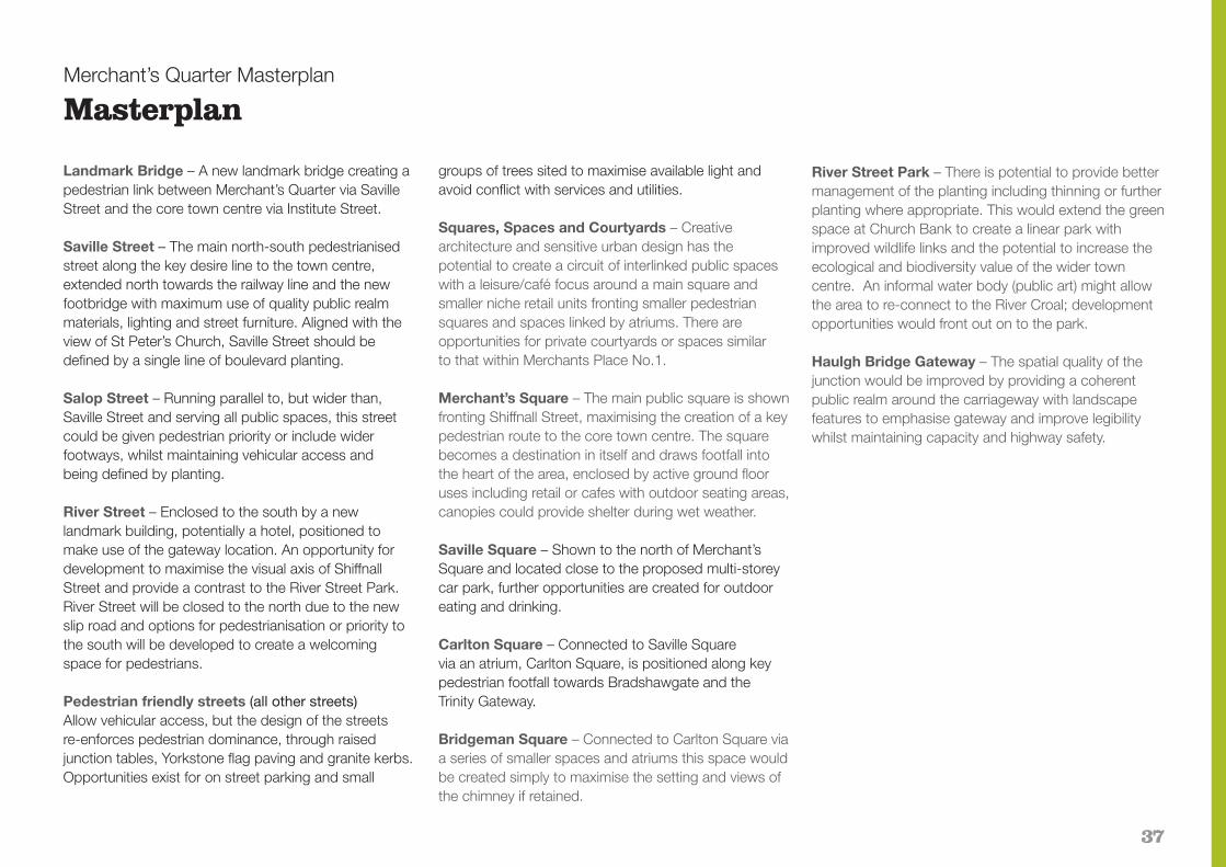
MasterplanFigure 25 Illustrative Masterplan Vision Diagram
37
Merchant’s Quarter Masterplan
Masterplan
Landmark Bridge – A new landmark bridge creating apedestrian link between Merchant’s Quarter via SavilleStreet and the core town centre via Institute Street.
Saville Street – The main north-south pedestrianisedstreet along the key desire line to the town centre,extended north towards the railway line and the newfootbridge with maximum use of quality public realmmaterials, lighting and street furniture. Aligned with theview of St Peter’s Church, Saville Street should bedefined by a single line of boulevard planting.
Salop Street – Running parallel to, but wider than,Saville Street and serving all public spaces, this streetcould be given pedestrian priority or include widerfootways, whilst maintaining vehicular access and being defined by planting.
River Street – Enclosed to the south by a newlandmark building, potentially a hotel, positioned to make use of the gateway location. An opportunity fordevelopment to maximise the visual axis of ShiffnallStreet and provide a contrast to the River Street Park.River Street will be closed to the north due to the newslip road and options for pedestrianisation or priority tothe south will be developed to create a welcoming space for pedestrians.
Pedestrian friendly streets (all other streets)Allow vehicular access, but the design of the streets re-enforces pedestrian dominance, through raisedjunction tables, Yorkstone flag paving and granite kerbs.Opportunities exist for on street parking and small
groups of trees sited to maximise available light andavoid conflict with services and utilities.
Squares, Spaces and Courtyards – Creativearchitecture and sensitive urban design has the potential to create a circuit of interlinked public spaceswith a leisure/café focus around a main square andsmaller niche retail units fronting smaller pedestriansquares and spaces linked by atriums. There areopportunities for private courtyards or spaces similar to that within Merchants Place No.1.
Merchant’s Square – The main public square is shownfronting Shiffnall Street, maximising the creation of a keypedestrian route to the core town centre. The squarebecomes a destination in itself and draws footfall into the heart of the area, enclosed by active ground flooruses including retail or cafes with outdoor seating areas,canopies could provide shelter during wet weather.
Saville Square – Shown to the north of Merchant’sSquare and located close to the proposed multi-storeycar park, further opportunities are created for outdooreating and drinking.
Carlton Square – Connected to Saville Square via an atrium, Carlton Square, is positioned along keypedestrian footfall towards Bradshawgate and the Trinity Gateway.
Bridgeman Square – Connected to Carlton Square viaa series of smaller spaces and atriums this space wouldbe created simply to maximise the setting and views ofthe chimney if retained.
River Street Park – There is potential to provide bettermanagement of the planting including thinning or furtherplanting where appropriate. This would extend the greenspace at Church Bank to create a linear park withimproved wildlife links and the potential to increase theecological and biodiversity value of the wider towncentre. An informal water body (public art) might allowthe area to re-connect to the River Croal; developmentopportunities would front out on to the park.
Haulgh Bridge Gateway – The spatial quality of thejunction would be improved by providing a coherentpublic realm around the carriageway with landscapefeatures to emphasise gateway and improve legibilitywhilst maintaining capacity and highway safety.

38
Merchant’s Quarter Masterplan
Masterplan
Figure 26 Movement FrameworkPolicy MQ1 Merchant’s Quarter MasterplanThe Council will permit development proposals that preserve or enhance the character orappearance of Merchant’s Quarter in accordancewith the Masterplan SPD and policies listedelsewhere in this section.
They should:(i) Retain and re-use those buildings identified in
the Building Quality Audit at Figure 14 in accordance with the advice in paragraphs 3.16 – 3.22;
(ii) Be of appropriate height, size, design, materials, roofscape and plot dimensions;
(iii) Retain materials, features, trees and open spaces that contribute to the character or appearance of Merchant’s Quarter;
(iv) Utilise appropriate materials for the surfacing and lighting of highways, footpaths and public squares together with appropriate street furniture;
(v) Not adversely affect important views into and across Merchant’s Quarter including the view of St Peter’s Church along Saville Street.

39
Merchant’s Quarter Masterplan
Masterplan
Transport, Accessibility, Parking and Movement FrameworkAs detailed previously, a Transport and Parking Assessment will supplement this section of the SPD andprovide further detail on access, parking and highwayimprovements. The following design objectives weretaken into account when formulating the movement framework:� Efficient access to and from the town centre network
including the provision of a slip road access off St Peter's Way to provide direct vehicular access to the proposed location for car parking off Breightmet Street and in accordance with the Council's overall Transport Strategy for the town centre;
� Parking demands for Merchant’s Quarter and surplusprovision for wider public parking;
� Potential multi-storey car parking options and an extension to the route of the town centre metroshuttle bus service;
� Restricting future pressure from individual developers to providing inefficient, piecemeal parking arrangements;
� Provide a legible arrival journey into Merchant’s Quarter;
� Adopt the Public Realm Implementation Framework approach in supporting a pedestrian friendly environment and providing pedestrian only zones along the whole length of Saville Street, and a small length to the south of River Street together with improved public realm throughout with street trees and furniture;
� Provide streets that can accommodate on street parking bays; and
� Appropriate consideration of recent new developments, planning permissions and planning applications.
Vehicular access and egressFigure 26 sets out the planned movement and parkingstrategy for Merchant’s Quarter. The strategy will be refined in accordance with the outcome of the TransportAssessment and Parking Supplement.
The primary access to Merchant’s Quarter will be northbound from the A666 via the planned slip road setout within the Transport Strategy, Coming to Bolton. This will lead vehicles from the Outer Highway Box directly into the planned parking zone for Merchant’sQuarter north of Breightmet Street. Southbound vehicleswill leave the A666 at the same junction and travel intothe area via Lower Bridgeman Street, Ash Street andCarlton Street. A third entry to Merchant’s Quarter ismaintained from Bradshawgate onto Shiffnall Street.
On leaving the major parking zones on BreightmetStreet, the primary exit for vehicles will be via SalopStreet to the Outer Highway Box via Bridgeman Place allowing access north or southbound onto the A666.Vehicles heading west will be able to access the OuterHighway Box at the Trinity Street junction via eitherBreightmet Street or Shiffnall Street and Bradshawgate.
The Council with GMPTE/GMPTA support introduced a free metroshuttle bus service to the town centre in2008. This service follows the one-way Gyratory Systemaround the town centre core area and along
Bradshawgate. The Council aims to expand the servicewith the support of key town centre stakeholders including developers, to serve the new multi-storey car parks within the town centre and will therefore investigate options for this service to include Merchant’sQuarter. The Transport Assessment and Parking Supplement will identify further options for this proposed extension.
Pedestrianisation of Saville Street is proposed includingthe provision of a new extended section of Saville Streetto maintain the grid structure and facilitate a direct routeto the planned footbridge over the railway. This pedestrianisation also aids the setting of planned newpublic squares in Merchant’s Quarter and would providea safer cycle route.
The proposed slip road results in River Street beingclosed to through traffic at its northern junction withBreightmet Street. Vehicular access is maintained viaShiffnall Street to those blocks west of River Street andthe planned hotel and parking provision east of RiverStreet. Pedestrianisation of River Street south of ShiffnallStreet is intended to facilitate an improved environmentfor pedestrians and setting for Merchant’s Place and theplanned hotel. Access and egress options for GlebeStreet onto the existing A666 slip road will be assessedas developments in that phase are proposed. GlebeStreet is currently shown one-way east on Figure 26.

40
Merchant’s Quarter Masterplan
Masterplan
ParkingThe parking strategy will be refined in accordance with the outcome of the Transport Assessment andParking Supplement.
‘Coming to Bolton’ aims to provide an efficient, sustainable transport system, which offers a realisticchoice of transport modes. Merchant’s Quarter has thepotential to deliver in the region of 500,000 sq ft of officeaccommodation and a further 100,000 sq ft of mixeduses. It is located in a highly sustainable location withinfive minutes walk of the proposed Transport Interchangeand is thus well served by a choice of modes oftransport. Nevertheless, in order to attract the calibreand critical mass of occupiers to make Merchant’sQuarter a destination for Grade A office users, as well asmaintain the parking supply for the wider town centre, an appropriate balance must be achieved between parkingsupply, demand and sustainable modes of transport, including walking and cycling.
The Council’s vision for town centre parking, is to reducethe number and scale of surface parking which is inefficient and generally poorer quality, whilst maintainingthe existing supply of parking places and making full useof sustainable modes of transport to cater for additionaldemand. Proposals for improvements to lighting, CCTVand Variable Messaging Systems, together with six multi-storey car parks are identified in ‘Coming to Bolton’and form the basis of the first phase being provided byNCP in partnership with the Council.
Breightmet Street is one such location identified for a new multi-storey car park and currently plays an important part, comprising approximately 300 spaces
which primarily serve the wider town centre with the newmulti-storey envisaged to be in the region of 600spaces, thus including an allowance for increaseddemand in Merchant’s Quarter.
More recent information confirms that typical parking demand from office occupiers is as low as 1 space per 8 sq m although typically 1 space per 20/25 sq m whilstthe maximum parking standards for urban areas in RSSand UDP Policy A6 is 1 space per 35 sq m. The Councilis also seeking to rationalise parking onto fewer sites inthe town centre. It is therefore anticipated that demand for parking from new office development alone in Merchant’s Quarter could be as high as 2000 spaces,well in excess of the 1400 spaces maximum that policies allow.
It is therefore anticipated that in the fullness of time aslow density industry and warehouse uses are replaced in Merchant’s Quarter by higher density office accommodation, further car parking provision will be required above and beyond the 600 spaces within theplanned Breightmet Street MSCP. Whilst the excellentlinks to the emerging Transport Interchange and theplanned multi-storey parking in the Trinity Gateway willabsorb some of this demand, additional multi-storey carparking will be required to serve Merchant’s Quarter.
Providing car parking on-site as part of a development isoften costly and results in dead frontages with visuallypoor louvres to facilitate natural ventilation and additionalinefficient trip generation which in Merchant’s Quarterwould conflict with the planned Movement Frameworkand proposed public realm improvements. The Council’spreferred location for such additional parking provision is
therefore on the periphery of the area with the northernand eastern edges of Merchant’s Quarter providing thebest access whilst freeing up the core areas for development opportunities and active frontages. Thesetwo locations are also predominantly existing surface carparks at present and thus the phased introduction ofhigher density, multi-storey car parking to suit demand ismore easily achieved.
The Breightmet Street Car Park is the primary preferred location for parking provision and offers potential for significant parking capacity together with ‘wrap around’commercial development to the new Saville Streetfrontage and where vehicular access permits, theBreightmet Street frontage also. It is intended that this sitewill be the first to be developed for multi-storey car parkingwithin Merchant’s Quarter.
The River Street Car Park adjacent to the planned hotel,which currently provides approximately 80 spaces, is thesecondary preferred location for multi-storey parking andthe Council will seek to use planning conditions to controlthe phasing of any development of multi-storey carparking such that it does not conflict with the preferredprimary location on Breightmet Street. River Street isrestricted in width such that an active frontage isprohibited. The pedestrianisation of River Street, activefrontage generated by Merchant’s Place and the plannedhotel will mitigate for this loss of active frontage. It isintended that multi-storey car parking will only bedeveloped on this site where options for multi-storey carparking on Breightmet Street Car Park have beenexhausted to the Council’s satisfaction in accordance withthe Transport and Parking Assessment.

41
Merchant’s Quarter Masterplan
Masterplan
The provision of surface, undercroft, ground floor ormulti-storey car parking elsewhere within Merchant’sQuarter will be resisted by the Council.
The access and movement strategy together with publicrealm improvements will support the parking strategy byproviding additional short-stay on-street parking withinthe inner road system.
United Utilities have adopted policies to keep clean water out of the public sewer, reducing foul flood risk,pollution at storm sewer overflows and carbon footprintand development proposals should be prepared in consultation with United Utilities particularly where anysurface parking is proposed.
Major Highway ImprovementsThe southern section of Merchant’s Quarter includes atriangular piece of land bounded by busy one-way highway movements on Lower Bridgeman Street,Bridgeman Place and Ash Street together with the major two-way junction at Trinity Street/ManchesterRoad where the B6536 radial route crosses the OuterHighway Box.
The Council will continue to investigate options, throughthe Transport and Parking Assessment, for reworking thehighway around Lower Bridgeman Street/BridgemanPlace/Ash Street/Manchester Road to facilitate improvedvehicular circulation and access. One option would involve closure of Lower Bridgeman Street to throughtraffic, creating improved pedestrian access and linkagesto the Westbrook area of the Bolton Innovation Zone tothe south. The capacity of the highway network and
junctions, together with access by larger vehicles andbuses would however need to be maintained and majorimprovements and potential road widening would be required along Bridgeman Place and at the junction withTrinity Street/Manchester Road.
It is anticipated that highway improvements will be necessary to maintain traffic flow and safeguard junctioncapacity as development proposals are implemented and trip generation increases. These works will be attributable as development costs to proposals for thewhole of Merchant’s Quarter on a pro-rata basis as eachdevelopment proposal will benefit from the highway improvements. It is likely that this will form an additionalrequirement under Section 106 powers or the emergingrequirements of the Community Infrastructure Levy in addition to any public realm contributions necessary. TheCouncil will identify the necessary highway improvementsand investigate options for the funding, pooling of moniesand phasing of highway improvements as part of theTransport and Parking Assessment Supplement.
Streets, spaces and linkagesFigure 27 indicates the proposed distribution of streetsand spaces within Merchant’s Quarter and their connection to the wider open space network. The proposals include:� New public destination spaces located along key
north/south and east/west linkages.� Appropriate management of landscaping adjacent to
River Street providing an extension of the green space at Church Wharf and enabling informal recreational access to be considered.
� A new ‘landmark’ pedestrian footbridge link will be
provided over the Bolton to Blackburn Railway to the north of the site linking Breightmet Street and an extended Saville Street with Clive Street and Institute Street connecting to wider east-west pedestrian movement corridor.
� Pedestrian only north/south connections along Saville Street and River Street (south) providing direct linkages between the Haulgh Bridge Gateway and the town centre via the new pedestrian footbridge.
� Public realm improvements to include pedestrian friendly, traffic-calmed streets throughout Merchant’s Quarter and improved cycle routes.
The Council Highway Authority will take a lead role in the introduction of the proposed movement frameworkas part of work implemented during the construction ofthe new A666 slip-road and the Breightmet Street multi-storey car park. The Council wishes to protect thismovement of traffic through one and two-way systemswithin Merchant’s Quarter together with the proposedpedestrianisation of Saville Street (as extended) and River Street (in part).
Policy MQ2A expands on UDP Policies A5 and A19 in particular by requiring development proposals to connect appropriately into the revised movement framework, including the new pedestrianised streets.Policy MQ2B expands on UDP Policies A5 and A6 inprotecting the planned parking provision for Merchant’sQuarter on strategic sites.
A new pedestrian footbridge will be provided. The linkmust be located centrally at the end of an extended Saville Street in response to the Merchant’s Quarter grid,

42
Merchant’s Quarter Masterplan
Masterplan
so that the public realm is navigable and to take the mostdirect route. The approach to the new link along Saville Street will frame an important view of the tower of St Peter’sChurch and symbolise the link across to the St Peter’s areaand core town centre.
The highways design should reflect the aspirations to create traditional street forms with distinct carriageways and footways. As the existing industrial uses are relocatedaway from the area, carriageways could be narrowed andcorner radii tightened to meet minimum standards as outlined in the Manual for Streets. The layout could, whereconsidered appropriate and safe, incorporate the following:� Two way traffic in streets;� No priority to all internal junctions;� On street parking; and� Dedicated loading bays
The funding and implementation of public realm works iscovered separately within the Improvement Plan of theCouncil’s adopted PRIF.
Cycle access and parkingMerchant’s Quarter is a relatively level site and the publicrealm improvements and Movement Framework, includingSaville Street and the footbridge in particular, will supportimprovements to safe cycle access within the area andpromote the use of cycling as an alternative mode oftransport to the private car. The Council is developing a cycle network across the borough and the town centre which will serve the core development areas including Merchant’s Quarter. In accordance with the UDP, minimalcycle parking will be a requirement of new developments and travel plans will need to take account of the requirementsof cyclists including shower and changing facilities.
Figure 27 Streets and spaces

43
Merchant’s Quarter Masterplan
Masterplan
Policy MQ2B ParkingThe Council will safeguard the Breightmet Street Car Park and River Street Car Park (north) sites indicatedon Figure 26 for the parking of cars and will permit development proposals for multi-storey car parking onthose sites subject to the following criteria:
(i) Multi-storey car parking will only be permitted on the River Street Car Park (north) site where the applicant has demonstrated that there is insufficient (existing) capacity on Breightmet Street Car Park to meet the proposed additional demand; and
(ii) Planning Conditions will be used to prevent the construction of multi-storey car parking on River Street until such time as proposals for Breightmet Street Car Park have been finalised.
The Council will not permit car parking proposals on sites elsewhere within Merchant’s Quarter unless the applicant has demonstrated that the existing and planned car parking provision in Merchant’s Quarter, thewider town centre and alternative modes of transport are insufficient to meet the proposed additional demand; or the parking provision is for a particular category that is not sufficiently met elsewhere (eg. disabled parking) and in any case such parking shall not exceed the maximum standards contained withinRSS and UDP Policy A6.
Policy MQ2A Movement FrameworkThe Council will safeguard the movement framework and layout of streets indicated on Figure 26 and in assessing development proposals will permit development proposals that would not prejudice the movementframework having taken into account provision for pedestrians, cyclists, road design, servicing, parking and public transport.

44
Merchant’s Quarter Masterplan
Masterplan
Public SquaresThe Council seeks the provision of a minimum three newpublic spaces and has identified their preferred locationwithin the masterplan. Each of these important spaceswill act as a focal point for the surrounding developmentand should contain an historic reference to inspire thecharacter and materials within the space. They are illustrated in Figure 25 and comprise the following areas(and suggested historic references) totalling approximately 4500 sq m.
� Carlton Square (Former Omnibus and Tram Depot site) – 1200 sq m
� Saville Square (Saville Mill [Cotton], Shakespeare Foundry) – 1600 sq m
� Merchant’s Square (Bridgeman Place Machine Works,Blackburn's Printers, Typesetting Works) – 1700 sq m
The most significant of these spaces is Merchant’sSquare. Given that the planned area for Merchant’sSquare falls within a single landownership, when takenwith recent improvements to River Street, this area couldform the first major transformational change within Merchant’s Quarter - providing a catalyst for further regeneration.
The size, purpose, function and location of these squaresis informed by the analysis in Part Three and thissupports their status as preferred option, in particular theproximity to the pedestrianisation of Saville Street and thelayout of important buildings at Carlton Square. TheCouncil does, however, recognise the nature of thedevelopment process, land assembly and the long termobjectives of Merchant’s Quarter. Through the application
of Policy MQ3 to development proposals, the Council acknowledges the status of the preferred location for thepublic squares including their minimum size and numberwhilst allowing flexibility for the public squares to bebrought forward on alternative sites providing they canbe justified in Urban Design terms as guided by UDPPolicy D2 and D3. This also allows other development tobe brought forward on the preferred public square sitesproviding their delivery elsewhere within Merchant’sQuarter is safeguarded.
Developers will clearly need to take account of the provision of public spaces when bringing forward proposals for any of the eight blocks within the core area and when proposing development on land that iscurrently identified for public space will need to include in their proposals, details of the delivery of that publicspace elsewhere within Merchant’s Quarter.
The public squares will need to be designed and landscaped to fully accord with the PRIF and UDP Policies D2 and D3. Public art is encouraged within the squares in accordance with UDP Policy D5. Thesesquares should be well lit, with lighting included as an integral part of the design and layout of the space.
The creation of public squares within the developmentwill create foci for activity and they should be designedto encourage their use through both formal and informalseating areas. It will be important that uses adjacent tothese squares facilitate and enhance the activity andtherefore should include ancillary café style uses whichshould spill out onto the public space.
Policy MQ3 Public SquaresThe Council will permit the development of three public spaces comprising a minimum 0.45 hectaresas indicated on Figure 27. The Council will not permit development proposals on any of the eight development plots within the core area (as defined by UDP Policy TC6) which prejudice the delivery ofany the following:(i) Public squares totalling a minimum 0.45
hectares within the core area;(ii) A minimum three public squares on any site
within the core area;(iii) Each public squares must be greater than
1000sq m in area.

45
Merchant’s Quarter Masterplan
Masterplan
Figure 28: Active and Semi-Active Frontages
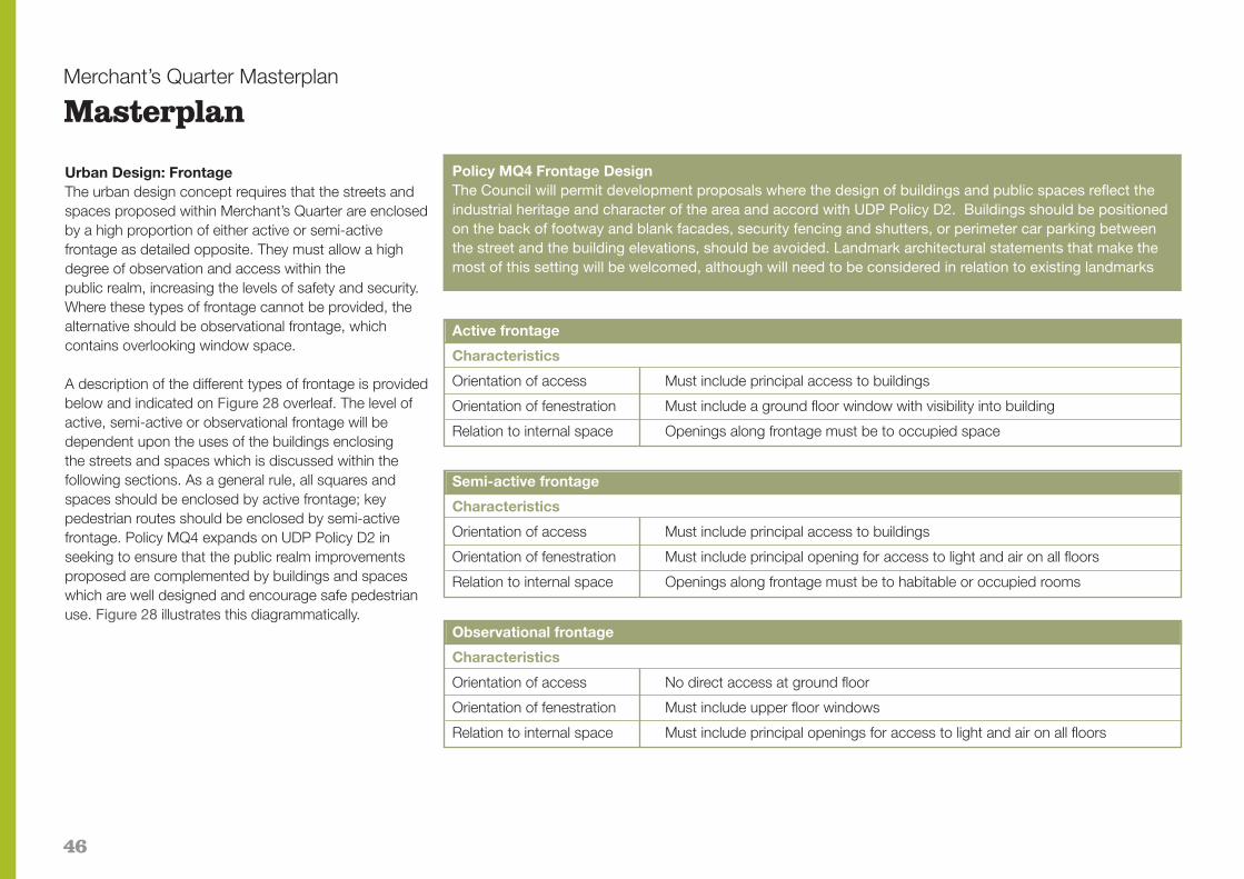
46
Merchant’s Quarter Masterplan
Masterplan
Urban Design: FrontageThe urban design concept requires that the streets andspaces proposed within Merchant’s Quarter are enclosedby a high proportion of either active or semi-activefrontage as detailed opposite. They must allow a highdegree of observation and access within the public realm, increasing the levels of safety and security.Where these types of frontage cannot be provided, thealternative should be observational frontage, which contains overlooking window space.
A description of the different types of frontage is providedbelow and indicated on Figure 28 overleaf. The level ofactive, semi-active or observational frontage will be dependent upon the uses of the buildings enclosing the streets and spaces which is discussed within the following sections. As a general rule, all squares andspaces should be enclosed by active frontage; keypedestrian routes should be enclosed by semi-activefrontage. Policy MQ4 expands on UDP Policy D2 in seeking to ensure that the public realm improvementsproposed are complemented by buildings and spaceswhich are well designed and encourage safe pedestrianuse. Figure 28 illustrates this diagrammatically.
Policy MQ4 Frontage DesignThe Council will permit development proposals where the design of buildings and public spaces reflect the industrial heritage and character of the area and accord with UDP Policy D2. Buildings should be positionedon the back of footway and blank facades, security fencing and shutters, or perimeter car parking between the street and the building elevations, should be avoided. Landmark architectural statements that make themost of this setting will be welcomed, although will need to be considered in relation to existing landmarks
Active frontage
Characteristics
Orientation of access Must include principal access to buildings
Orientation of fenestration Must include a ground floor window with visibility into building
Relation to internal space Openings along frontage must be to occupied space
Semi-active frontage
Characteristics
Orientation of access Must include principal access to buildings
Orientation of fenestration Must include principal opening for access to light and air on all floors
Relation to internal space Openings along frontage must be to habitable or occupied rooms
Observational frontage
Characteristics
Orientation of access No direct access at ground floor
Orientation of fenestration Must include upper floor windows
Relation to internal space Must include principal openings for access to light and air on all floors

47
Merchant’s Quarter Masterplan
Masterplan
Use mixBolton is emerging as a leading regional centre andthrough the Bolton Brand values is promoting a vibrantand distinctive town centre to be proud of which appealsto and is popular with all.
The Community Strategy describes ““……aa ggrreeaatt ppllaaccee ttoo ggrrooww uupp,, lliivvee,, lleeaarrnn,, wwoorrkk,, ddoo bbuussiinneessss aanndd vviissiitt;; ssoo tthhaatt tthhee ppootteennttiiaall ooff eeaacchh ppeerrssoonn,,eeaacchh ccoommmmuunniittyy aanndd tthhee bboorroouugghh aass aa wwhhoollee ccaann bbee rreeaalliisseedd..””
In terms of the overall vision, the area could re-invent itself to create a bohemian character, within a truly mixeduse quarter and a hub of creative businesses.
Whilst heavily underpinned by the provision of high quality office facilities with access to parking, as well astown centre facilities; the overall objective would be toretain skilled people trained and qualified at the University, offering incubator space and access to sharedfacilities, gallery and exhibition/studio space, creative industries, niche/quirky retailing and a range of occupiersthat are looking for centrally located, yet affordable accommodation, focused around squares and spacesand mixed with cafés, bars and restaurants.
Upper floors of these active hub areas and less activeareas could also include a large amount of B1 office,mixed with convenience shops and leisure uses, such asgymnasiums. Supporting the use mix within Merchant’sQuarter would be a necessary level of residential accommodation to create a critical mass within theQuarter, and ensure activity and vibrancy into the
evening. The Quarter could access an important niche byproviding affordable apartments which are not typicallyavailable elsewhere in the town.
Active and evening uses should be focused around key streets and spaces; buildings along key spacesshould also provide a mix of uses between ground andupper floors.
Policy MQ5 Permitted UsesWith regard to development proposals within thecore area protected by UDP Policy E5 the Councilwill
Policy MQ5 Permitted usesWith regard to development proposals within the core area protected by UDP Policy the council will permitClass B1 office led proposals. Other development proposals including those comprising single or a mix ofancillary uses such as those listed in Paragraph 4.49 above will be assessed against UDP Policy E5 and thefollowing criteria, and providing that the benefits of the proposals outweigh any disadvantages, will be permitted:
(i) ancillary uses include Class A1 retail; Class A2 office; Class A3 restaurant/café; Class A4 bar; Class A5 take away; Class C1 hotel; Class C2 residential institution; Class D1 non-residential institution and Class D2 assembly and leisure uses;
(ii) ancillary uses listed at (i) will normally be limited to the ground floor at key road junctions and facing public squares or open spaces created as part of the development and will not normally utilise all the ground floor accommodation except that part of Merchant’s Quarter fronting Bradshawgate;
(iii) multi-storey car parking will be permitted where it accords with the relevant UDP policies, town centre transport strategy, this SPD and the Transport and Assessment Supplement;
(iv) Class C3 residential development will not be permitted unless it covers less than 15% of the total GIA of any development proposal for the whole of a Development Area (as defined by Figure 1), fronts onto either Bradshawgate or a public square, and where at least two other uses (one of which must be Class B1 office space) are included in the proposal. Such proposals will be rigorously tested against the primary criteria set out in Policy E5.

48
Merchant’s Quarter Masterplan
Masterplan
The Council will permit development proposals for carparking, hotel (Class C1) or other landmark office (ClassB1) building on land between River Street, the A666 andthe new slip road.
The Council has reserved land to the north of BreightmetStreet for a multi-storey car park under UDP Policy TC7.The Breightmet Street MSCP will complement the objectives for the industrial area comprising a high qualityfrontage, ideally to the back of pavement, with buildingentrances off the street frontage. Although more functional, the railway elevation also needs to project aclear visual identity and logic through the massing ofbuildings, particularly in the area of the proposed footbridge which should be treated as a gateway to Merchant’s Quarter as well as the site.
Frontages to the car park should maintain visual interestthrough the provision and location of openings andpedestrian entrances. Solid facades should be avoided.A commercial development opportunity to complementuses within Merchant’s Quarter is appropriate on thewestern façade adjoining the pedestrian link which willalso act as a screen to the car park and provide adequate surveillance. Entrances and stairwells shouldform interesting features to the car park and be well litand welcoming. The use of lightweight materials such asglazing will be actively encouraged.
Policy MQ6 UDP Allocation TC7On that part of land within Merchant’s Quarter to the north of Breightmet Street no longer required for multi-storey car parking including that part of the land allocated under UDP Policy TC7 the Council will permit development proposals for uses complementary to the broad objectives of Merchant’s Quarter providing such proposals accord with the other relevant UDP policies.

49
Figure 29 Scale and massing
Merchant’s Quarter Masterplan
Masterplan
Urban Design: Scale and massingThe Masterplan adopts an urban design approach toscale and massing, as identified in Figure 29, which reflects the importance of the street grid. New buildingsshould respect the general height of existing buildingswith increases in scale to define key entrances, gatewaysand vistas. Sensitive additions to existing buildings, including the roof, will be considered. In addition emphasis has been given to:� The River Street gateway at the junction of River
Street and Bridgeman Place;� The River Street/park entrance;� The Salop Street entrance;� The new Saville Street entrance to the primary
pedestrian route;� Creating varying building scales along the Saville
Street route;� The extended Saville Street, leading to the footbridge;� The Breightmet Street entrance;� The Salop Street entrance;� Shiffnall Street.
Policy MQ7 Street GridThe Council will permit development proposals that respect, enhance and reinforce the existing grid of streets. Development proposals that have a detrimental impact on the grid will only be permitted where there is an overriding justification or benefit that would outweigh any disadvantages and would not otherwise arise as a result of any other development proposal.
6
50
Merchant’s Quarter Masterplan
Masterplan
Figure 29 indicates the range of building heights that willnormally be considered appropriate. However, that is notto say that a uniform height across a block will be acceptable. It is broadly considered that building heightsup to 6 storeys will be acceptable. However, it may bepossible to incorporate elements that are higher than indicated to act as visual foci and this will need to bedemonstrated on a case by case basis taking full consideration of the advice contained within this SPD,Building Bolton and the UDP. Building heights for individual blocks are unlikely to be uniform and shouldvary to break up the massing of individual blocks.Developers should make full use of the Council’s in-house urban design and conservation expertise in thedevelopment stages of proposals and will be encouragedto present their proposals at pre-application planningstage to the Northwest Design Review Panel. Guidanceon Tall Buildings has been prepared by CABE and English Heritage and should be referred to in the preparation of buildings that are taller than those proposed in Figure 29.
Policy MQ8 Building HeightsThe Council will permit building heights that are in accordance with the those illustrated on Figure 29. The Council will permit building heights that vary from those on Figure 29 where a development proposal can be fully justified taking into account the objectives of Merchant’s Quarter and UDP Policy D2.
AdvertisementsA proliferation of advertisements within Merchant’s Quarter, including free-standing, projecting and wallmounted signage, must be avoided. Illuminated signage
should be avoided unless this can be shown to enhancethe character of the area. Development proposals should consider the likely tenant requirements for advertisements in their conception. This will be particularly important where the sensitive conversion ofbuildings restricts the opportunity for advertisements that compliment the architecture of the building and especially where a range of complimentary uses are proposed rather than a single office user. Developersshould seek the advice of the Local Planning Authority at pre-application stage and refer to UDP Policy D4 and PCPN6.
ArchaeologyMerchant’s Quarter includes three sites with potential forarchaeological interest (although no parts are ScheduledAncient Monuments). Saville Mill, Globe Works and the Carlton Street Depot are listed on the Sites andMonuments record. In consultation with the GreaterManchester Archaeological Unit (GMAU), developmentproposals will need to consider archaeological issuesand agree with the Local Planning Authority any mitigation that is found to be appropriate. Consultationwith GMAU should be instigated as early as possible atpre-application stages to avoid delay in thedetermination of a submitted application due to the needto carry out pre-determination archaeological evaluation. Development proposals will be required to conductinvestigations into archaeological value of a site in accordance with UDP Policies D14 and D15.
Wireless environment and telecommunicationsThe use of wi-fi and broadband technology to facilitatean enhanced business environment promoting
Merchant’s Quarter as Bolton’s first complete wireless internet hotspot will be encouraged. Such a network couldspan the entire area, giving workers internet access viatheir laptop or mobile phone allowing people to sendemails, make cheap phone calls, surf the internet, dobusiness and even play games online, wherever they are.Comprehensive development should seek to investigateemerging technology as part of proposals, including new“mesh” technology to transfer users automatically frombase station to base station as they walk by, allowinguninterrupted web use. Base stations may be required tocover the area with users charged a small monthly fee.
There are many conventional internet hotspots around thecountry, covering almost all the major hotels and hundreds of coffee shops. However, they require users to log in every time. Emerging technology allows users tolog in only once.
Wireless technology such as this has major appeal to bigfinancial institutions with the ability to access boardroomscreating a corporate requirement. Wi-fi technology supports mobile phones that instead of connecting to amobile phone network, log onto a wireless hotspot andsend calls over the internet.
Comprehensive development will need to consider atelecommunications strategy to ensure that standard mobile phone usage and the potential for wireless technology are fully catered for at a strategic level. Appropriate locations for telecommunications equipmentshould be identified in consultation with operators and inaccordance with national guidance and UDP Policy D6and PCPN25.
51
Merchant’s Quarter Masterplan
Masterplan — Public Realm Strategy & Planning Obligations
Public Realm Implementation FrameworkThe success of the town centre as a place for pedestrians to move through and gather depends agreat deal on how safe and comfortable they feel. Forexample, public spaces will not be attractive for pedestrians to linger if the vehicle traffic is too heavy or too close.
The Council’s adopted Public Realm ImplementationFramework (PRIF) acknowledges the Transport Strategyand seeks as a matter of priority, to adjust the balance infavour of the pedestrian making the whole town centre apedestrian friendly environment. In Part 1 of the PRIF, the Strategy acknowledges the tight urban grain in Merchant’s Quarter and historic buildings, setting out thekey linkages, permeability and potential for high qualitypedestrian connections and public space. The PRIF promotes a no nonsense public realm approach with ahard, uniform urban character and making full use of thestreet width without allowing traffic to dominate.
The section on Strategic Routes acknowledges the importance of the west/east route from Bolton Market toInstitute Street and states: ‘Some new critical links andan extension to the east are proposed which wouldcomplete [the] route of strategic importance, generatingfoot traffic and connecting hitherto separate areas.’ Itgoes on to refer to the proposed railway footbridge aswell as identifying a longer term goal to bridge over theA666 to residential areas outside the town centre. Theroute between Merchant’s Quarter and Church Wharf isalso identified for improvements.
Merchant’s Quarter is described as having ‘the worstlighting in Bolton’ which contributes to negative perceptions of the area. The Lighting Strategyrecognises the importance of both functional andarchitectural lighting and in particular states thatreplacing the low pressure sodium (SOX) lamps isessential for Merchant’s Quarter to create a saferenvironment and match that of other areas in the towncentre. The chimneys on Globe Works and Salop Streetare identified for architectural lighting because of theirmerit and position on key routes.
In Chapter 7, the PRIF provides a detailed assessmentof Merchant’s Quarter and the proposed public realmmap is replicated at Figure 30. Developers should referto this section of the PRIF direct however, the importantkey elements it identifies are:
� Grid Structure - Merchant’s Quarter has the most clearly distinct urban form in the town centre.
� Streets - Public realm design must maintain the integrity of the street grid as a matter of priority.
� Tree Planting - Tree planting only within open space/squares and key streets.
� Car park and Merchant’s Square - Acknowledging the proposed MSCP and slip road together with the benefits of creating a new public space next to the new footbridge(s).
� Salop Square - A bold public realm statement within the street grid is proposed.
� Saville Street Footbridge - Supporting the Council’s aspiration for the creation of a new pedestrian footbridge link over the railway.
� St Peters Way Footbridge - Supports the Town Centre Transport Strategy aspiration for footway link across the A666 .
� Extensions of the grid - Proposes that the grid is extended to the North and East to give a hard edge to River Street in particular.
� Bridgeman Place/Lower Bridgeman StreetReduction in carriageway widths with improved crossing points.
� Yards, passageways and alleys - Make pedestrian connections using these smaller private spaces.

52
Merchant’s Quarter Masterplan
Masterplan — Public Realm Strategy & Planning Obligations
Figure 30 Public Realm Implementation Framework – Merchant’s Quarter 1 Pedestrian path
2 Footbridge
3 Existing and proposed urban blocks, potential extent
4 Green space
5 Trees
6 Public square
7 Street/road with carriageway and footways vehicular priority
8 Strategically importantpedestrian crossings
1
2
3 4
567
8

53
Merchant’s Quarter Masterplan
Masterplan — Public Realm Strategy & Planning Obligations
Figure 31 Public Realm Implementation Framework – Merchant’s Quarter Street Type

54
Merchant’s Quarter Masterplan
Masterplan — Public Realm Strategy & Planning Obligations
Part 2 of the PRIF comprises the Design Baseline settingout clear detailed guidelines on the materials, road andjunction design, furniture, lighting and planting to be usedin the town centre. The proposals are not prescriptiveand rather make recommendations for the many aspects of public realm design sufficient to set a qualitybenchmark for implementation teams. It is intended thatsuch teams will interpret the recommendations providingthis is done comprehensively and strategically to maintain consistency and quality.
Typically, the PRIF promotes a traditional street for Merchant’s Quarter as shown at Figure 31 above, withasphalt carriageway and a combination of large Yorkstone flags and granite kerbs. Developers shouldrefer to the PRIF itself for further detailed guidance onpublic realm design including furniture, lighting planningtogether with detailed costs. In order to achieve themajor transformation of the area and attract the necessary investment to Merchant’s Quarter, PRIF anticipates public realm costs in excess of £16million.
Policy MQ9 Public RealmThe Council will permit development proposals that include or fund the design and provision of good public realm - the strategy, baseline standard, and preferred proposals for which are contained within the Council’s adopted Public Realm Implementation Framework.
Planning Obligations (Including Section 106 Legal Agreements)Following adoption of the PRIF, the Council’s approach totown centre planning obligations has been set out withinBolton Town Centre Planning Obligations which has beenadopted by the Council as an Interim Statement of Policyprior to its formal consideration as part of the Local Development Framework.
The Council is seeking thorough this policy, contributionsfrom development proposals towards the costs of delivering the public realm framework within Bolton towncentre, which those development proposals will benefitfrom. Developers have the option to either implement that part of the PRIF which directly affects their scheme,or contribute an equivalent sum of money to enable theCouncil to pool resources and deliver strategic sections of public realm which could not otherwise be delivered ina piecemeal fashion. Table 3 on page 55 illustrates howthe funding would be divided between the DevelopmentAreas, should the development proposals come forwardin the manner and scale suggested in the masterplan.
The developer delivered option involves the developeragreeing the extent of the scheme with the Local Planning Authority and Strategic Development Unit, usually during pre-application discussions and submittinga detailed scheme as part of the planning application setting out materials, planting, lighting, furniture, etc. Thedeveloper then implements the proposal which is securedby planning condition, as part of the development worksand usually under a separate Section 278 HighwayAgreement with the Council funded by the Developer.
This process also ensures the works are carried out tothe Council’s adoptable highway standards, although in certain cases a minor street or space may become privately maintained whilst remaining open to the public. The commuted sum option involves the developer paying for the public realm works in a commuted sum secured via a Section 106 legal agreement negotiated with the Council at the pre-application stages. The Council will then pool thatresource to enable the delivery of strategic public realmworks in Merchant’s Quarter.
In both scenarios, the extent of the public realm scheme,or the level of contribution, are initially set by theamounts within Bolton Town Centre Planning Obligations. These amounts will need to be programmedinto a developer’s financial appraisal for the site and any subsequent negotiations with regard to reducedcontributions where the scheme viability is affected as a result, will need to be discussed at pre-applicationstages and/or submitted as part of the planning application.
Given that the costs contained within the PRIF, illustratedat Table 3, are likely to be in excess of amounts generated by the planning obligation process alone, theCouncil will seek to fully investigate options for grantfunding to match these contributions to the costs of thehigh quality public realm identified.

55
Merchant’s Quarter Masterplan
Masterplan — Public Realm Strategy & Planning Obligations
Table 4 Illustrative Public Realm Costs
Merchant's Quarter Development Area Area (sqm) Storeys* Total GIA (sqm) PRIF Contribution
Public Realm Implementation Framework £16,000,000
Breightmet St N/Bradshawgate 829 4 3316 £190,151.24
Breightmet St N 10121 5 50605 £2,901,870.83
Shiffnall St N/Bradshawgate 5769 5 28845 £1,654,074.98
Shiffnall St N/Carlton St 5230 5 26150 £1,499,534.08
Shiffnall St N/Salop St 4168 5 20840 £1,195,039.78
Saville Mill Complex 4812 5 24060 £1,379,686.04
Shiffnall St S/Bradshawgate 5024 5 25120 £1,440,470.22
Bridgeman Place Works 4926 5 24630 £1,412,371.87
Shiffnall St S/Salop St 4909 5 24545 £1,407,497.67
Commerce House 1855 6 11130 £638,233.82
Bradshawgate/Ash Street 2927 7 20489 £1,174,912.19
Globe Works 3215 6 19290 £1,106,157.26
53785 279020 £16,000,000.00
* Based on a massing average from Figure 29
Public Realm DevelopmentThe remainder of this section seeks to develop the publicrealm strategy for Merchant’s Quarter in light of the workby Planit EDC on the masterplan concept completed following the adoption of the PRIF. Developers will be expected to show compliance with this section whensubmitting public realm proposals in accordance withPolicy MQ9.
Streets provide a strong and consistent industrial character which should be enhanced through good public realm design. On street parking and servicing isproposed within Merchant’s Quarter, not only to encourage passing trade, but also to resolve the demands short stay parking and servicing.
By integrating the parking into the design of the carriageway the visual impact of parked vehicles areminimised. Further, the presence of parked vehicleswithin the street scene increases the level of activity andobservation, and thus improves safety and security.
Street planting is proposed to build on the green character particularly dominant to the east of RiverStreet, historically the banks of the River Croal. Sympathetic tree planting would serve to provide a distinctive character to the streets, acting as a foil to theindustrial heritage and would also serve to define keypedestrian routes through the study area.
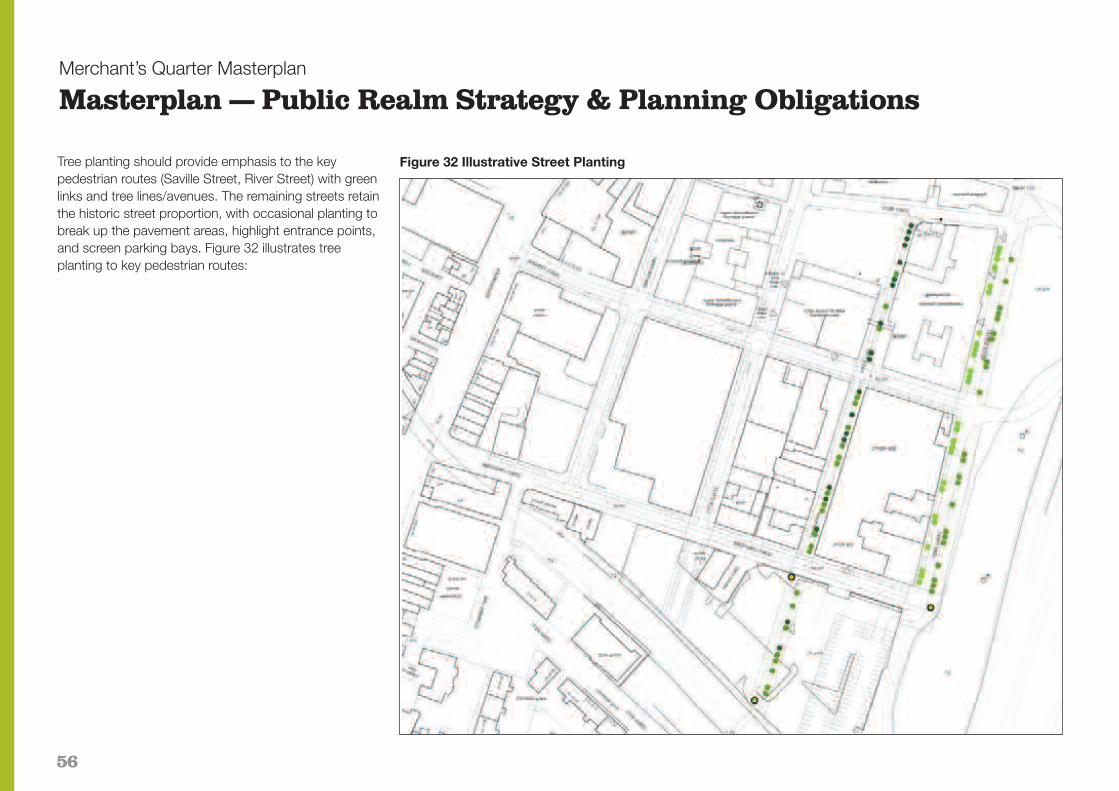
56
Merchant’s Quarter Masterplan
Masterplan — Public Realm Strategy & Planning Obligations
Tree planting should provide emphasis to the key pedestrian routes (Saville Street, River Street) with greenlinks and tree lines/avenues. The remaining streets retainthe historic street proportion, with occasional planting tobreak up the pavement areas, highlight entrance points,and screen parking bays. Figure 32 illustrates treeplanting to key pedestrian routes:
Figure 32 Illustrative Street Planting

57
Merchant’s Quarter Masterplan
Masterplan — Public Realm Strategy & Planning Obligations
The PRIF recognises the significant service issues withtree planting around the existing utilities. This can be resolved through a reduction of road width to allow fortree planting within a widened footpath. Trees should sitwithin a tree trench with root barrier to adjacent existingservices. Developers will need to consider and submitdetailed method statements with planning applications.
Appropriate species include:� Medium sized semi-mature avenue trees that tolerate
shade and urban conditions;
� Narrow columnar trees with crown spread 3-4m proposed where planted close to kerb line;
� Trees with pyramidal crown to pedestrianised Saville Street.
'Green Streets' should be created comprising tree planting where possible thus providing a green canopyand a personal 'scale' to the street. These would havethe benefit of improving legibility within the locality bydefining pedestrian through routes, thus establishing hierarchy. The trees should follow simple/straight kerb lines.
Linking Streets would contain dispersed tree plantingcombined with parking and servicing spaces togetherwith new street lighting columns contained within the tree line. Lighting levels could be increased throughwall/building mounted lighting to create safe walkingroutes. The provision of seating in line with the street provides opportunity for informal gathering and further animates the edges.
Street trees elsewhere within the quarter are inappropriate bearing in mind existing constraints (such as services) and the character of the area.
Junctions should include a continuous pavement linewhich has the perception of running across the roadway, thus having the impact of slowing vehiclespeeds and increasing pedestrian safety. Opportunityexists to introduce corner planting in the form of landmark trees, which could be located without compromising highway safety. This will provide maximum pedestrian benefit in terms of quality andspace whilst still allowing buildings to be accessed andserviced. The tightening up of vehicular movementspace would dramatically reduce vehicle speed and increase the safety and quality of environment forpedestrians.
Figure 33 River Street and Saville Street Section
Figure 34 Salop Street and Shiffnall Street Section

58
Figure 35 Saville Street (North) Section
Merchant’s Quarter Masterplan
Masterplan — Public Realm Strategy & Planning Obligations
Figure 36 Salop Street and Shiffnall Street Section

59
Merchant’s Quarter Masterplan
Masterplan — Public Realm Strategy & Planning Obligations
Figure 37 Junction Table Design LightingLighting proposals within Merchant’s Quarter will be designed to fulfil the following objectives and BritishStandards:� To create a sense of security and safety for
pedestrians from service vehicles and to deter antisocial behaviour;
� To create a sense of cohesion and identity within Merchant’s Quarter;
� The lighting equipment should be carefully selected to integrate with the hard and soft landscape and its surrounding buildings.
The Merchant’s Quarter lighting scheme will be designedin accordance with the following British Standards:(i) BS5489 Part 9:1996 - Code of practice for lighting
for urban centres and public amenity areas;(ii) B55489 Part 3:1996 - Code of practice for lighting for
subsidiary roads and associated pedestrian areas;(iii) The Chartered Institute of Building Services Engineers
(CIBSE) LG6; and(iv) The Institution of Lighting Engineers (ILE): Guidance
Notes for the reduction of light pollution 1994.
Illumination on vertical surfaces will be promoted to improve people’s recognition and create a greater senseof security and safety for the public. Different lampcolours will be also be used to guide people through thelandscaped areas and create visual interest.
The lighting levels within the development, measured atground floor level, shall be an average of 25 LUX inpedestrian areas and 15 LUX in vehicular areas.
To minimise light pollution high quality light fittings thatuse asymmetric optics, light refracting screens and Fresnel lenses are proposed. All lamps will be metalhalide optics which are ideal for urban settings as theydraw out the natural colours in materials and are low energy.
CCTVAn integrated strategy for dealing with security includingCCTV coverage will need to be considered as part of thecomprehensive approach to regeneration of Merchant’sQuarter. The area has suffered from anti-social behaviourin the past and a co-ordinated investment in the creationof a secure, well managed and maintained environmentwill contribute to improved perceptions and a feeling ofsafety and wellbeing for those working and visiting thearea, thus reducing the fear of crime and opportunitiesfor criminal behaviours. Such facilities must complementthe wider Town Centre CCTV strategies and objectives,including secure parking and the proposed CCTV Control Centre and consider detailed constraints such asthe location of trees within the streets and spaces, whilstavoiding clutter and safeguarding the architecture andcharacter of the area.

60
Merchant’s Quarter Masterplan
Masterplan — Implementation and Phasing
Comprehensive developmentThis SPD has identified the following broad objectives forthe delivery of Merchant’s Quarter:� Comprehensive economic regeneration through the
provision of an office led urban business quarter;� A range of complementary uses with a ‘24 hour’
economy that will generate activity and create a destination to support the vitality and viability of the wider town centre;
� High quality public realm improvements comprising road design; surfacing; landscaping; lighting; furniture and public spaces;
� A co-ordinated transport, movement and parking strategy including new slip road; public multi-storey car park; and pedestrian linkages; and
� Protection of important heritage assets including the street grid, architectural characteristics and buildings of merit.
In order to deliver the scale and quality anticipated by this SPD, a critical mass of development will be required.Small scale, piecemeal developments will not generatesufficient returns to support the level of investmentneeded to transform Merchant’s Quarter into a successful urban business quarter and therefore will not be supported by the Council.
For the purpose of this section, ‘Development Areas’ arethose parts of Merchant’s Quarter currently comprisingbuildings, surface car parking or private open spacewholly enclosed by all or a combination of the following: (i) existing and proposed streetgrid; (ii) railway line; (iii)green space east of River Street. Figure 1 indicates theproposed Development Areas.
Proposals for comprehensive regeneration by a single developer or developer consortium of a whole Development Area; more than one Development Area; or the whole Merchant’s Quarter area, will generate sufficient critical mass to support the necessary infrastructure, including public realm improvements, that small scale or piecemeal development could not. Piecemeal development including partial development of a Development Area or subdivision, would thereforeprejudice the ability for comprehensive schemes to generate that critical mass.
It is critical to the movement framework and character ofthe area that a co-ordinated approach to car parking isachieved. With the exception of planned multi-storey carparking, the Council will not normally support individualdevelopment proposals that include on-site car parking(undercroft or surface). Development proposals will berequired to make best use of the on-street and multi-storeycar parking proposed within Merchant’s Quarter.
As a minimum requirement, planning applications should include the proposals for a whole DevelopmentArea irrespective of planned phasing of development. For example Merchants Place was submitted in a single application, although it has been implemented in twophases. This ensures that development achieves the design objectives set out within the masterplan and prevents piecemeal development on one part of a Development Area prejudicing the remainder of that plot or the objectives of Merchant’s Quarter as a whole.
Policy MQ10 Comprehensive DevelopmentThe Council will permit development proposals for one or more whole Development Areas as indicated on Figure 1 that are in accordance with the UDP and this SPD. Piecemeal development proposals for part of a Development Area will not be permitted where they prejudice the comprehensive regeneration of Merchant’s Quarter.
Policy MQ11 ParkingThe Council will permit development proposals which rely on and utilise planned multi-storey car parking on Breightmet Street or on other approved parking locations within Merchant’s Quarter for their respective parking allocation. Development proposals which include on-site car parking will only be permitted where it can be shown that there is insufficient provision of spaces elsewhere within Merchant’s Quarter to meet the anticipated demand.
PhasingWith Merchants Place No.1 completed and No. 2 due to commence, the first phase of Merchant’s Quarter iswell underway and the adjacent sites to the west, northand east form the logical next stage in that phase of development. Key infrastructure projects including theBreightmet Street multi-storey car park, slip road andfootbridge, together with some public realm improvements are due to commence in the followingphase and will complement the subsequent phased development of Merchant’s Quarter which is expected to broadly move from east to west across the area.

61
Merchant’s Quarter Masterplan
Masterplan — Implementation and Phasing
DemolitionThe grid pattern of streets and industrial architectureform a critical part of the character of Merchant’s Quarter. This SPD builds on the advice within BuildingBolton and identifies those high value buildings which it is anticipated will be retained and converted into commercial office space within the Section on BuildingQuality (Figure 14). There are no listed buildings withinMerchant’s Quarter and where conversion is appropriate,significant internal demolition may still be justified.However, sensitive conversion with retention of keyhistoric features, such as has been implemented withinthe Merchant’s Place development, will be encouragedas part of development proposals.
Planning permission is not required for the demolition ofbuildings within Merchant’s Quarter. Nevertheless, demolition of those buildings of high value as identified in Figure 14, will be a material consideration in the determination of planning applications which require theirdemolition to facilitate redevelopment. Such planning applications will be expected to fully consider the localdistinctiveness, architectural or historic value of buildingsand must be supported by a detailed assessment andjustification. The poor structural condition and/or economic viability of a project due to the high cost of retaining and converting the whole or part of such a building or structure may be factors which justify demolition.
Whole scale, unrestrained demolition and clearance ofdevelopment plots containing important buildings or features could damage the character of the area,
however the considered demolition of those buildingswhich fail to enhance the area or have a negative visual impact, such as the Saville Mill complex, will besupported where such proposals can be shown to be attracting further investment to the area. Proposals would be justified for example, in circumstances where a derelict, low value building was sited next to a complete phase of development awaiting occupation.
Development proposals that include demolition will need to consider the impact on protected species and archaeology and include supporting information and justification to comply with the relevant policies and guidance.
Demolition which cannot be justified may result in inappropriate development contrary to UDP Policy D2and will not be supported unless complying with PolicyMQ12 below:
Policy MQ12 DemolitionThe Council will permit development proposals that require the whole or partial demolition of those high value buildings within Merchant’s Quarter identified within Figure 14 providing that all reasonable efforts have been made to find sympathetic, appropriate, viable uses, and have failed; and its redevelopment would produce substantial benefits for the area which would decisively outweigh the loss of the building and where agreements are made to secure the approved redevelopment scheme is carried out within a specified timescale.
62
Merchant’s Quarter Masterplan
Appendix 1
List of relevant documents and weblinks
Business Boltonwww.businessbolton.org
Community Strategywww.boltonvision.org.uk
Unitary Development Planwww.bolton.gov.uk/planning
Local Development Framework: Local Development Scheme
Statement of Community Involvement
Town Centre Action Frameworkwww.bolton.gov.uk/tcaf
Development and Regeneration Position Statementwww.businessbolton.org/hot
Coming to Bolton: Town Centre Transport Strategywww.bolton.gov.uk/tcts
Town Centre Parking Strategywww.bolton.gov.uk/tcts
Public Realm Implementation Frameworkwww.bolton.gov.uk/publicrealm
Building Bolton SPDwww.bolton.gov.uk/buildingboltonSustainable Design and Construction SPDwww.bolton.gov.uk/sdcspd
Breightmet Street Development Briefwww.bolton.gov.uk/breightmetstreet
Bolton Town Centre Planning Obligations 2008 – 2013
Making Design Policy Work: How to Deliver Good Design through your Local DevelopmentFrameworkwww.cabe.org.uk
Protecting Design Quality in Planning (CABE)
Design at a Glance: A Quick Reference Wall Chart to National Design Guidance (CABE)
Historic Towns and Cities in England’s Northwest www.nwda.co.uk/publications/infrastructure
Green Infrastructure Guide for the North Westwww.greeninfrastructurenw.co.uk/resources
North West Best Practice Design Guidewww.nwra.gov.uk/documents
Sustainability Checklist (4NW)www.sdchecklist-northwest.org.uk
Surface Water and Highway Drainage (United Utilities)www.unitedutilities.com
Conservation Principles (English Heritage)www.english-heritage.org.uk
Guidance on Tall Buildings(CABE/English Heritage)
63
List of TablesTable 1 Relevant National Planning Policies 9Table 2 Relevant Unitary Development Plan Policies 13Table 3 Relevant Planning Control Policy Notes 15Table 4 Illustrative Public Realm Costs 55
List of FiguresFigure 1 Merchant’s Quarter Boundary and Development Areas 4Figure 2 Unitary Development Plan 2005 Extract 8Figure 3 Bolton Town Centre Character Areas 16Figure 4 Urban Design Analysis 19Figure 5 Aerial Photograph 2006 20Figure 6 OS Plan 1793 22Figure 7 OS Plan 1845 22Figure 8 OS Plan 1890 22Figure 9 OS Plan 1894 22Figure 10 OS Plan 1966 22Figure 11 Urban Structure and Sections 23-24Figure 12 Axonometric Aerial Photograph Overlay 25Figure 13 Scale and Massing Plan 25
Merchant’s Quarter Masterplan
Appendix 2
Figure 14 Building Quality 26Figure 15 Building Uses 28Figure 16 Land Uses 28Figure 17 Vehicular Movement Routes 29Figure 18 Pedestrian Movement Routes 29Figure 19 Public Realm Distribution 30Figure 20 Opportunities and Constraints 31Figure 21 Statutory Services 32Figure 22 Masterplan Option 1 35Figure 23 Masterplan Option 2 35Figure 24 Masterplan Option 3 35Figure 25 Illustrative Masterplan Vision Diagrams 36Figure 26 Movement Framework 38Figure 27 Streets and Spaces 42Figure 28 Active and Semi-Active Frontages 45Figure 29 Scale and Massing 49Figure 30 Public Realm Implementation Framework 52Figure 31 Public Realm Implementation Framework – Street Type 53Figure 32 Illustrative Street Planting 56Figure 33 River Street and Saville Street Section 57Figure 34 Salop Street and Shiffnall Street Section 57Figure 35 Saville Street (North) Section 58Figure 36 Shiffnall Street 58 Figure 37 Junction Table Design 59

For further information, contact:Keith DaviesDirector of Development and RegenerationTel: 01204 334002email: [email protected]
Phil GreenDevelopment ManagerTel: 01204 336036email: [email protected]
AcknowledgementsThanks to Planit who provided the images andevidence based information www.planit-ie.com
Large print, interpretation, text only and audio formats of this document can be arranged on request. Please call 01204 334117 or email communications&[email protected]
As part of Bolton’s commitment to a sustainable future, this document is printed (using vegetable based inks) on paper sourced from sustainable forests www.bolton.gov.uk