- B : G – A D EARNING C EGREE EOGRAPHICAL NFORMATION ...
6
1 KÖBBEN - BLOK: GIMA – A DISTANCE LEARNING MSC DEGREE IN GEOGRAPHICAL INFORMATION MANAGEMENT ... GIMA – A DISTANCE LEARNING MSC DEGREE IN GEOGRAPHICAL INFORMATION MANAGEMENT AND APPLICATIONS Köbben, Barend 1 Blok , Connie 2 International Institute for Geo-information Sciences and Earth Observation, ITC (The Netherlands), [email protected] 1 , [email protected] 2 Abstract: The International Institute for Geo-information Science and Earth Observation (ITC) and three Dutch uni- versities (Technical University of Delft, Wageningen University and Utrecht University) have joined forces to organise an MSc degree in Geographical Information Management and Applications, called GIMA. This is a four year, half-time programme, offered as distance learning, with only a few short periods of traditional classroom learning. The course is targeted at Dutch bachelors, foreign bachelors and mid-career professionals. Teaching had to be made interactive by us- ing various ICT-means, such as the Blackboard digital learning environment on the web, video and audio-conferencing, et cetera, with a strong emphasis on maintaining regular communication between participants and teachers and among participants. This paper will introduce the GIMA course setup, discuss the challenges and solutions in educating geo- information sciences using distance-learning tools and will discuss the experiences from it’s the first two years. DISTANCE EDUCATION AT ITC The International Institute for Geo-information Science and Earth Observation (ITC), based in Enschede (the Nether- lands), has over 50 years of experience in the field of training in a wide range of disciplines related to Geoinformatics. At the ITC, knowledge of geoinformation management is amply available, and continually being developed and extended. By means of education, research and consulting, ITC contributes to capacity building in the developing world. ITC’s core mission is to transfer knowledge by providing training and education to less developed countries. ITC is facing the challenge of keeping its educational materials up-to-date and providing high-level education using mod- ern technology. Distance learning, broadly defined as ‘a method of studying in which lectures are broadcast or conducted by correspondence, without the student needing to attend a school or college’, offers the potential to provide flexible and effective means to professionals at any place of the globe. Distance education can have many forms, see eg. [1]. If ITC wants to remain competitive and customer-oriented in its training effort it has to keep up with this development and pro- vide interesting, high-quality, demand-driven distance learning courses to its students. Two additional forces push ITC towards distance learning formats. Firstly, coming to Enschede to follow regular degree courses involves a stay of several months to several years in the Netherlands, away from your working environment and usually separated from your families. Many students would rather take short diploma courses or (series of) shorter degree courses in which the stay abroad is limited to a few months. Secondly, because science develops at a ever faster pace, the depreciation rate of knowledge acquired by ITC students increases considerably. Therefore it becomes more and more important to keep updating the knowledge of ITC alumni who have completed an ITC course but who have to keep up with technology in order to provide sustainable development. Using open learning tools and distance education, ITC could provide an efficient and flexible educational environment to keep its alumni updated. In this way, knowledge is provided at those moments that it is needed for problems at hand in organisations. By avoiding depreciation of knowledge, effectiveness of ITC education would increase. Another important aspect is that the impact of courses on the graduates’ working organisation is often limited. Many graduates do not succeed in implementing what they have learnt, because the organisation and their colleagues have not changed with them. When graduates would carry out course assignments in their own working environment, the organisation can grow gradually along with the student. All this has led to an active interest at ITC in the application of distance education techniques. In order for ITC to suc- cessfully enter this field of education, new to ITC, an appropriate framework for the implementation and activation of distance learning is required. Following first experiments with a small three-week elective module [2], the vision is that ITC’s education will move towards a modular, hybrid course programme, a combination of traditional and distance learn-
Transcript of - B : G – A D EARNING C EGREE EOGRAPHICAL NFORMATION ...

1
KÖBBEN - BLOK: GIMA – A DISTANCE LEARNING MSC DEGREE IN GEOGRAPHICAL INFORMATION MANAGEMENT ...
GIMA – A DISTANCE LEARNING MSC DEGREE IN GEOGRAPHICAL INFORMATION MANAGEMENT AND
APPLICATIONS
Köbben, Barend1
Blok , Connie2
International Institute for Geo-information Sciences and Earth Observation, ITC (The Netherlands),[email protected] 1, [email protected] 2
Abstract: The International Institute for Geo-information Science and Earth Observation (ITC) and three Dutch uni-versities (Technical University of Delft, Wageningen University and Utrecht University) have joined forces to organise an MSc degree in Geographical Information Management and Applications, called GIMA. This is a four year, half-time programme, offered as distance learning, with only a few short periods of traditional classroom learning. The course is targeted at Dutch bachelors, foreign bachelors and mid-career professionals. Teaching had to be made interactive by us-ing various ICT-means, such as the Blackboard digital learning environment on the web, video and audio-conferencing, et cetera, with a strong emphasis on maintaining regular communication between participants and teachers and among participants. This paper will introduce the GIMA course setup, discuss the challenges and solutions in educating geo-information sciences using distance-learning tools and will discuss the experiences from it’s the first two years.
DISTANCE EDUCATION AT ITC
The International Institute for Geo-information Science and Earth Observation (ITC), based in Enschede (the Nether-lands), has over 50 years of experience in the field of training in a wide range of disciplines related to Geoinformatics. At the ITC, knowledge of geoinformation management is amply available, and continually being developed and extended. By means of education, research and consulting, ITC contributes to capacity building in the developing world. ITC’s core mission is to transfer knowledge by providing training and education to less developed countries.
ITC is facing the challenge of keeping its educational materials up-to-date and providing high-level education using mod-ern technology. Distance learning, broadly defined as ‘a method of studying in which lectures are broadcast or conducted by correspondence, without the student needing to attend a school or college’, offers the potential to provide flexible and effective means to professionals at any place of the globe. Distance education can have many forms, see eg. [1]. If ITC wants to remain competitive and customer-oriented in its training effort it has to keep up with this development and pro-vide interesting, high-quality, demand-driven distance learning courses to its students.
Two additional forces push ITC towards distance learning formats. Firstly, coming to Enschede to follow regular degree courses involves a stay of several months to several years in the Netherlands, away from your working environment and usually separated from your families. Many students would rather take short diploma courses or (series of) shorter degree courses in which the stay abroad is limited to a few months. Secondly, because science develops at a ever faster pace, the depreciation rate of knowledge acquired by ITC students increases considerably. Therefore it becomes more and more important to keep updating the knowledge of ITC alumni who have completed an ITC course but who have to keep up with technology in order to provide sustainable development. Using open learning tools and distance education, ITC could provide an efficient and flexible educational environment to keep its alumni updated. In this way, knowledge is provided at those moments that it is needed for problems at hand in organisations. By avoiding depreciation of knowledge, effectiveness of ITC education would increase. Another important aspect is that the impact of courses on the graduates’ working organisation is often limited. Many graduates do not succeed in implementing what they have learnt, because the organisation and their colleagues have not changed with them. When graduates would carry out course assignments in their own working environment, the organisation can grow gradually along with the student.
All this has led to an active interest at ITC in the application of distance education techniques. In order for ITC to suc-cessfully enter this field of education, new to ITC, an appropriate framework for the implementation and activation of distance learning is required. Following first experiments with a small three-week elective module [2], the vision is that ITC’s education will move towards a modular, hybrid course programme, a combination of traditional and distance learn-

2
KÖBBEN - BLOK: GIMA – A DISTANCE LEARNING MSC DEGREE IN GEOGRAPHICAL INFORMATION MANAGEMENT ...
ing tools. One of the ongoing projects is to implement the introductory GIS and Remote Sensing modules that most de-gree programmes start with, plus five popular short courses, in a distance learning form. They will be set up for part-time studying, in a combination of self study and extensive online support. Successful completion of such a course would lead to exemption for the corresponding module in the degree courses. Starting with the 2005-2006 study year, MSc students meeting certain requirements can do most of their thesis period in their own country, with supervision provided at a dis-tance. This can be done 5 months full-time or part-time, with a maximum duration of 1 year.
Next to all these ITC-specific efforts, the GIMA course was thought to be an excellent occasion for serious efforts in distance learning in a co-operative setting.
WHY GIMA?
With the growing role of geo-information in many sectors of society, employers all over Europe are in need of all-round geo-information application specialists and managers of geo-information, and increasingly also in need of these people on an academic level. Aspects of geo-information sciences are offered by various academic institutes in the Netherlands, but only as relatively small parts of other programmes in their course curricula (e.g. Geography, Agricultural Sciences, Engineering), and management aspects are usually not emphasized. ITC offers programmes in Geoinformatics and Geo-information Management at levels ranging from Diploma, Professional Masters, MSc to PhD-level [3], but due to its financing model, these courses are primarily attracting participants from less developed countries. To fulfill the need for managers and application specialists in the Netherlands and in other than less developed countries, three Dutch universi-ties (the Technical University Delft, Utrecht University and Wageningen University and Research Center) and ITC started to offer GIMA: a primarily distance learning MSc course in Geographical Information Management and Applications. The target group consists of Dutch and foreign holders of at least a bachelors degree in more or less related (relevant) field of science and mid-career professionals. Basic knowledge of (and experience in) geo-information, together with pro-ficiency in English are admission requirements. Since 2003, the programme attracted 63% bachelors/masters from higher vocational training/colleges and 37% from universities. The proportions of foreign and Dutch participants are respectively 21 and 79%; 84% consists of professionals, the remaining 16% are students. This variation, shown in figure 1, is a chal-lenge, but interaction between participants with different experience and backgrounds is also considered stimulating and beneficial.
Figure 1: Variation in background of GIMA students
WHAT IS GIMA?
Aims and distinguishing features
The aims of the GIMA course are: • providing specialised knowledge, skills and insights in all aspects of geo-information; • prepare the students for a professional career as an all-round manager of geo-information, a specialist in geo-
information applications and/or a researcher in the field of geo-information.
To these ends, the participants are equipped with up-to-date knowledge of geo-information technologies, their scientific development and fields of application. They also acquire skills in geo-data handling processes, gain insights in the role of geo-data within and between organisations and learn to manage geo-information departments, units and projects.

3
KÖBBEN - BLOK: GIMA – A DISTANCE LEARNING MSC DEGREE IN GEOGRAPHICAL INFORMATION MANAGEMENT ...
There are a number of distinguishing features characterizing the programme. It is a ‘blended’ learning programme, con-sisting of distance learning from the home countries of the participants for most of the time, with short periods of class-room learning during the introduction and at the start and the end of each of the six programme modules. The class room periods are sequentially given in Enschede, Utrecht, Wageningen and Delft, the places where the cooperating institutes are located. Hence, foreign participants have to travel several times to the Netherlands. The programme is flexible in the sense that full time participation for two years is offered (since 2004), but half time participation in a the four years programme, is also possible since 2003. This is attractive for mid-career professionals, etc. who want (or need) to maintain their job. It is possible to follow one or more single modules. In that case, a certificate will be issued upon successful completion.
Distance education requires the use of ICT means for interactive teaching and as didactical tools. For GIMA this in-cludes: • The electronic learning environment ‘Blackboard’ on the Web [4] • E-mail contacts • Internet telephoning • Online presentations using web cams • Video/audio conferencing • Participation in chat sessions
Distance education also requires a high degree of self-learning, but the philosophy in GIMA is to promote cooperative learning in groups as well. Case studies and projects for small groups are included to stimulate team building and to benefit from different experience and backgrounds. Even when working on individual tasks, participants are supposed to try to solve problems encountered in the group before teachers are contacted. This is meant to stimulate contacts among students and to prevent that some participants become technically or socially stuck. If it works well, it also saves staff time. Since Blackboard is used as medium to pose questions, staff is able to monitor the solutions proposed and can, if necessary, give hints, decide to interfere or help.
Programme management and organization
A number of bodies are involved in management and organization of the course: • A Programme Board: is responsible for the overall management, financial affairs and policies; • A Programme Director and Programme Coordinator: appointed to take care of all daily affairs; • A Coordinator for each of the nine programme components (see below); • An Educational committee, containing an equal number of staff and student representatives to discuss educa-
tional matters; • An Admissions and an Examinations Committees: having more specialized responsibilities.
Each of the participating institutes is represented in the Programme Board and in the Educational, Admission and Exami-nation Commissions. The aim is to divide costs and benefits of programme execution equally among the partners. The four institutes are jointly involved in providing education: in each single module, at least two different institutes are involved. Plenary meetings of Board members and all the staff involved in the execution of the Programme (about 30 teachers) are organized at least once per year; more frequent meetings are held among the staff involved in a particular module.
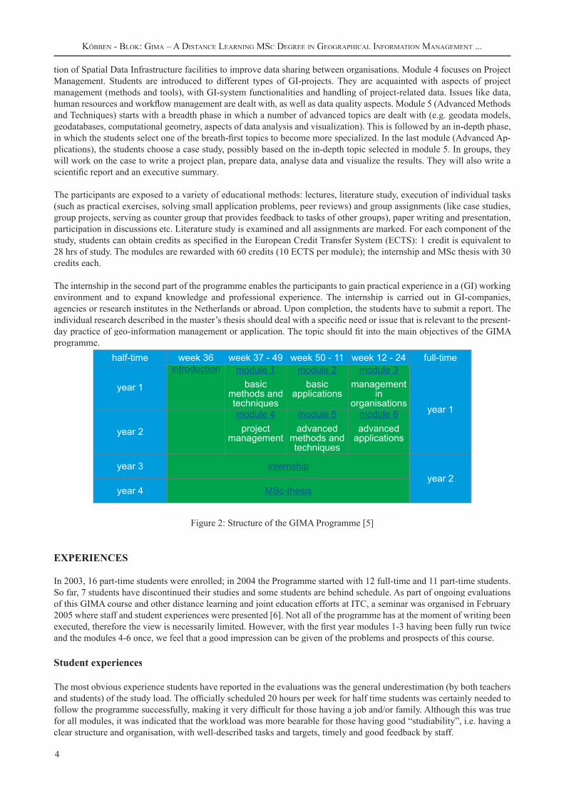
Structure of the programme
After an introduction (of 4 days), the first part of the programme contains six modules of thirteen weeks each (see figure 2). Each module starts with a class room introduction of three days, followed by a distance learning period that ends with two days of module examinations and presentations of case studies or project results. In total, there are four classroom periods per year for modules 1-6, hosted by one of the participating institutes. The second part of the programme contains an internship of 6 months full-time or 12 months half-time, and a Master’s thesis (also lasting a minimum of 6-12 months for full//half-time participants respectively).
Module 1 (Basic methods and techniques) is meant to bring the students at a common basic level of knowledge of data acquisition, storage, manipulation/analysis and visualization. In module 2 (Basic Applications) the students are first intro-duced to different types of GI (Geo-Information)-projects and data sets needed for those projects. Issues like data quality, project planning and data handling are dealt with. Next, the students select a case and work group wise on the selected project. In module 3 (Management in Organisations), students are acquainted with different types of organisations dealing with GI and with their roles. They are also introduced to management and information management methods and tools, and learn to write a management strategy (or business plan) for a specific GI-organisation. The plan focuses on incorpora-
4
KÖBBEN - BLOK: GIMA – A DISTANCE LEARNING MSC DEGREE IN GEOGRAPHICAL INFORMATION MANAGEMENT ...
tion of Spatial Data Infrastructure facilities to improve data sharing between organisations. Module 4 focuses on Project Management. Students are introduced to different types of GI-projects. They are acquainted with aspects of project management (methods and tools), with GI-system functionalities and handling of project-related data. Issues like data, human resources and workflow management are dealt with, as well as data quality aspects. Module 5 (Advanced Methods and Techniques) starts with a breadth phase in which a number of advanced topics are dealt with (e.g. geodata models, geodatabases, computational geometry, aspects of data analysis and visualization). This is followed by an in-depth phase, in which the students select one of the breath-first topics to become more specialized. In the last module (Advanced Ap-plications), the students choose a case study, possibly based on the in-depth topic selected in module 5. In groups, they will work on the case to write a project plan, prepare data, analyse data and visualize the results. They will also write a scientific report and an executive summary.
The participants are exposed to a variety of educational methods: lectures, literature study, execution of individual tasks (such as practical exercises, solving small application problems, peer reviews) and group assignments (like case studies, group projects, serving as counter group that provides feedback to tasks of other groups), paper writing and presentation, participation in discussions etc. Literature study is examined and all assignments are marked. For each component of the study, students can obtain credits as specified in the European Credit Transfer System (ECTS): 1 credit is equivalent to 28 hrs of study. The modules are rewarded with 60 credits (10 ECTS per module); the internship and MSc thesis with 30 credits each.
The internship in the second part of the programme enables the participants to gain practical experience in a (GI) working environment and to expand knowledge and professional experience. The internship is carried out in GI-companies, agencies or research institutes in the Netherlands or abroad. Upon completion, the students have to submit a report. The individual research described in the master’s thesis should deal with a specific need or issue that is relevant to the present-day practice of geo-information management or application. The topic should fit into the main objectives of the GIMA programme.
half-time week 36 week 37 - 49 week 50 - 11 week 12 - 24 full-time
year 1
introduction module 1basic
methods and techniques
module 2basic
applications
module 3management
in organisations
year 1
year 2
module 4project
management
module 5advanced
methods and techniques
module 6advanced
applications
year 3 internshipyear 2
year 4 MSc-thesis
Figure 2: Structure of the GIMA Programme [5]
EXPERIENCES
In 2003, 16 part-time students were enrolled; in 2004 the Programme started with 12 full-time and 11 part-time students. So far, 7 students have discontinued their studies and some students are behind schedule. As part of ongoing evaluations of this GIMA course and other distance learning and joint education efforts at ITC, a seminar was organised in February 2005 where staff and student experiences were presented [6]. Not all of the programme has at the moment of writing been executed, therefore the view is necessarily limited. However, with the first year modules 1-3 having been fully run twice and the modules 4-6 once, we feel that a good impression can be given of the problems and prospects of this course.
Student experiences
The most obvious experience students have reported in the evaluations was the general underestimation (by both teachers and students) of the study load. The officially scheduled 20 hours per week for half time students was certainly needed to follow the programme successfully, making it very difficult for those having a job and/or family. Although this was true for all modules, it was indicated that the workload was more bearable for those having good “studiability”, i.e. having a clear structure and organisation, with well-described tasks and targets, timely and good feedback by staff.

5
KÖBBEN - BLOK: GIMA – A DISTANCE LEARNING MSC DEGREE IN GEOGRAPHICAL INFORMATION MANAGEMENT ...
Full-time students find it often difficult to work on two modules (e.g. modules 1 and 4) in the same period. The fact that tasks often have to be submitted for both modules at (about) the same date, and that exams are scheduled closely after each other causes constant pressure.
In general, students are positive about the distance learning tools offered. The standard tools in Blackboard, things such as the on-line materials, email feedback, discussion boards and digital dropboxes, were deemed useful and easy to use, but it was noted that their effectiveness was depending mainly on the actual use that students, and staff, make of them: online feedback requires staff to react promptly, otherwise it turns into a time-consuming and frustrating exercise. Additional tools have been used in some modules, sometimes introduced by staff, such as presentations via webcam in module 3, sometimes as initiatives of a particular student group, such as internet voice conferencing in module 6. Another positive point is the wide range of geoinformatics methods and techniques the students get exposed to, ranging from geostatistical calculation methods to building websites for data dissemination (figure 3).
Figure 3: Screenshot of website made by module 2 group 5 (spatial impact of Enschede fireworks disaster).
Staff experiences
Of the 30 or so staff from the four participating institutes that have contributed to GIMA, for most this was their first experience with distance– and blended–learning techniques. Furthermore some staff did not have experience with mixed student groups from various countries (this was less the case for staff from Wageningen University and especially from ITC). The programme has posed some interesting challenges: In general, keeping track of what students and fellow staff are doing turned out to be one of the major issues. One has to regularly communicate to students and there is a need for a steady stream of reports, results, and other feedback, and even then it is difficult to keep up with their progress and avoid losing track of individuals.
Some of the more clearly defined problems were centred around the practical parts of the programme. Not surprisingly, having students do practical tasks using GIS software elsewhere is quite different from having them do that in a computer cluster within your teaching organisation. In the latter case, the teacher has full control over the soft- and hardware avail-

6
KÖBBEN - BLOK: GIMA – A DISTANCE LEARNING MSC DEGREE IN GEOGRAPHICAL INFORMATION MANAGEMENT ...
able. This is not the case in the GIMA course. Although all students did receive the same ESRI ArcGIS software, some will run this at home on relatively simple computers, while others might have access to much more resources in their workplace. Furthermore, the students have received a limited functionality ArcView evaluation license, which also did turn out to be impossible to update. Because most staff use the full ArcInfo version, planned exercises sometimes turned out to impossible to achieve for the students. A more structural problem is the difficulty to offer technical help and solu-tions on–line. In a classroom situation the students can show his or her attempts, giving staff the chance to observe and where necessary jump in and correct mistakes or technical glitches. In a distance–learning situation, firstly the students find it much harder to explain the problem, secondly the teacher cannot easily offer feedback; all this leads to extensive email or discussion board sessions, with questions and suggestions for solutions going back and forth. Added to this was the fact that many exercises were done not by individual students, but in groups of two or three. One can understand that the feedback process took considerable amounts of time and sometimes led to frustration on both sides.
All in all, much staff time was needed to run the GIMA course, possibly more than was expected beforehand for a dis-tance-learning course with only very limited contact hours. Results of the evaluations are used to improve the programme. An official, external evaluation will be conducted in 2007.
REFERENCES
1. Tam, S.W. (1998): Developing Countries and the Future of Distance and Open Learning in the Twenty-first Century. e-JIST, Electronic Journal of Instructional Science and Technology, 3 (1998) 1, pp. 22-28. <http://www.usq.edu.au/electpub/e-jist/>2. Köbben, B.J. (2002): Distance education at ITC: developing a Webcartography module using Blackboard and the Web. In: Proceedings of Third European GIS Education Seminar. Girona (Spain): Universitat de Girona, pp. 8-12.3. ITC Education website: http://www.itc.nl/education/ (Last access date: May 30, 2005)/ (Last access date: May 30, 2005)/4. ITC Blackboard site: http://bb.itc.nl (Last access date: May 30, 2005)5. GIMA website: http://www.msc-gima.nl/ (Last access date: May 30, 2005)/ (Last access date: May 30, 2005)/6. Augustijn, E-W., Eelderink, L.: Distance education and blended learning in the MSc course GIMA.On: http://intranet.itc.nl/education/education%20seminar%20series/documents/augustijn9feb05_000.pdf(Last accessed May 30, 2005).